
Map which Don Francisco Antonio Marín del Valle,...
17
Map which Don Francisco Antonio Marín del Valle, Governor and Captain General of this kingdom of New Mexico, ordered drawn 1758 1: Santo Domingo Pueblo 1760 Quote: (1760) This pueblo of Keres Indians is six leagues north of Sandia upriver. There are no settlers here. The mission priest is a Franciscan friar. It comprise 67 families, with 424 persons. Four leagues before we reached this pueblo, we passed opposite another called San Felipe, which is on the other bank of the river. And on this other side they arranged a nice arbor and under it a fine lunch, for in few places would a better one be made. The mission priest of San Felipe prepared it at his own expense. and after it was over and we had proceeded a quarter of a league, the aforesaid governor of the kingdom came out to meet us in his two-seated chaise, and from there we traveled together to Santo Domingo. He dined there and returned to his capital, but he left the chaise at my disposal. Having made my visitation and confirmations, I left for Santa Fe on the twenty-fourth of May, now leaving the river and traveling toward the east. I reached the house of El Alamo, six leagues from Santo Domingo. It is large, with an upper story and many corridors. There the governor had left everything for the midday meal ready. Here the captain of the peaceful Apaches Indians came to call on me. This man is esteemed in the kingdom because of his old loyalty. He warns of the coming of Comanches, and in war he and his men are a safe ally. But they have not been able to persuade him to become a Christian. I begged and exhorted him. He excused himself on the ground that he was now too old to learn how to recite the catechism. I endeavored to facilitate matters for him. I got nowhere. Everyone desieres his conversion because he displays good qualities, and they hope that the same thing may happen to him as to another captain who was unwilling while he was in good health but who asked for baptism when he was on the point of death, which would be going to see the Great 9 8 10 7 6 5 3 2 4 1 11 National Park Service, Washington, D.C. - Terms of Use
Transcript of Map which Don Francisco Antonio Marín del Valle,...

Map which Don Francisco Antonio Marín del Valle,Governor and Captain General of this kingdom of NewMexico, ordered drawn1758
1: Santo Domingo Pueblo
1760
Quote: (1760) This pueblo of Keres Indians is six leagues north of Sandia upriver. There are no settlers here.The mission priest is a Franciscan friar. It comprise 67 families, with 424 persons.
Four leagues before we reached this pueblo, we passed opposite another called San Felipe, which is on theother bank of the river. And on this other side they arranged a nice arbor and under it a fine lunch, for in fewplaces would a better one be made. The mission priest of San Felipe prepared it at his own expense. and afterit was over and we had proceeded a quarter of a league, the aforesaid governor of the kingdom came out tomeet us in his two-seated chaise, and from there we traveled together to Santo Domingo. He dined there andreturned to his capital, but he left the chaise at my disposal.
Having made my visitation and confirmations, I left for Santa Fe on the twenty-fourth of May, now leaving theriver and traveling toward the east. I reached the house of El Alamo, six leagues from Santo Domingo. It islarge, with an upper story and many corridors. There the governor had left everything for the midday mealready.
Here the captain of the peaceful Apaches Indians came to call on me. This man is esteemed in the kingdombecause of his old loyalty. He warns of the coming of Comanches, and in war he and his men are a safe ally.But they have not been able to persuade him to become a Christian. I begged and exhorted him. He excusedhimself on the ground that he was now too old to learn how to recite the catechism. I endeavored to facilitatematters for him. I got nowhere. Everyone desieres his conversion because he displays good qualities, and theyhope that the same thing may happen to him as to another captain who was unwilling while he was in goodhealth but who asked for baptism when he was on the point of death, which would be going to see the Great
9
8
10 7
6
5
3
24
111National Park Service, Washington, D.C. - Terms of Use

Captain, for so they call God. And as soon as he received holy baptism, he died. [Tamarón y Romeral, Pedro]
Overview: Santo Domingo Pueblo
In the seventeenth century, Santo Domingo, a Keres pueblo, boasted the best convent in New Mexico and wasthe repository of the Franciscans' archives. It remains an important pueblo in New Mexico. [Long DistanceTrails Group--Santa Fe, National Park Service, New Mexico State Office, Bureau of Land Management]
Images:
Bridge across the Rio Grande at Santo Domingo Pueblo
2: Cochiti
1760
Quote: (1760) This pueblo of Keres Indians is about fourteen leagues south southwest of San Ildefonso....
They received me in a large house belonging to a settler opposite the pueblo on the east side of the river. Iwanted to cross to the other side in a canoe, but they made difficulties. And there the people had brought thegenizaros across. [Tamarón y Romeral, Pedro]
Overview: Cochiti Pueblo
Cochiti has remained an important pueblo throughout the colonial, Mexican, and U.S. periods.
This small Keresan pueblo has occupied the same site on the west bank of the Río Grande since 1250 A.D. Thefirst European visitor was Fray Agustín Rodriguez in 1581. The Mission of San Buenaventura was built between1625 and 1630 and was burned during the Pueblo Revolt.
When the reconquest began, the Cochiti people fled to a mountain stronghold named Cieneguilla. After deVargas conquered Cieneguilla most of the Indians returned to
Cochiti to help construct a new mission; it is still standing. The Camino Real ran close to Cochiti Pueblo andpassed through an ancient pueblo likely of Cochiti heritage. [Long Distance Trails Group--Santa Fe, NationalPark Service, New Mexico State Office, Bureau of Land Management]
Images:
Standing portrait of two unidentified Cochitiwomen in Native American dress
San Buenaventura Mission Church, Cochiti Pueblo. Dance of the Ayosh-tyu-cotz at Cochiti Pueblo

3: Santa Fee
1760
Quote: (1770) Here I received a petition which I shall relate because of its unusual nature. A woman fifteenyears of age, who had already been married for five years, presented herself, asking for the annulment of hermarriage because she had been married at the age of ten. Then the husband, who was a soldier of thepresidio, appeared. The fact that the marriage had taken place when she was ten years old was verified, butthere was also proof that she immediately conceived and bore a son, and then another, and that she wasalready pregnant with the first child at the age of eleven. For this reason her petition was not valid, and thecouple was ordered to continue in the state of matrimony. [Tamarón y Romeral, Pedro]
Overview: Santa Fé
Santa Fe was for centuries the end of the Camino Real, and has almost always been the seat of government inNew Mexico. Most of the original town was built between 1610-1612, and centered around the plaza. Thebarrio of Analco, across the Río de Santa Fé from the plaza, was one of the main genízaro settlements of NewMexico from its founding at least until the late eighteenth century
The Casas Reales, or the Palace of the Governors, was built in 1610 when Santa Fé was established. Peopletook refuge in it during the Indian siege of August 1680. Subsequently, this seat of government was occupiedby the Pueblo rebels, again by the Spanish, by the Mexican Provincial governors, by U.S. General Kearny, theConfederate Army, and a string of American Territorial governors. [Long Distance Trails Group--Santa Fe,National Park Service, New Mexico State Office, Bureau of Land Management]
Quote: Every calculation based on experience elsewhere fails in New Mexico...--Lew Wallace, Governor of Territorial New Mexico, 1878-1881
Images:
House in Santa Fe San Miguel church, the oldest in America
Links: Santa Fe- Official Visitor Site -- http://santafe.org/Palace of the Governors: Museum of New Mexico -- http://www.palaceofthegovernors.org/
4: Pecos
1760
Quote: (1760) Here the failure of the Indians to confess except at the point of death is more noticable,because they do not know the Spanish language and the missionaries do not know those of the Indians. theyhave one or two interpreters in each pueblo, with whose aid the missionaries mangage to confess them, whenthey are in danger of dying. And although they recite some of the Christian doctrine in Spanish, since they donot understand the language, they might as well not known it.
This point saddened and upset me more in that kingdom than any other, and I felt scruples about confirmingadults. I remonstrated vehemently with the Father Custos and the missionaries, who tried to excusethemselves by claiming that they could not learn those languages. In my writs of visitation I ordered them tolearn them, and I repeatedly urged them to apply themselves to this and to formulate catecishms and guide toconfession, of which I would pay the printing costs. I asked the Father Custos to give me a report about this in

writing, and he gave me the one contained in a paragraph of a letter dated November 7, 1761, which reads asfollows:
Father Fray Tomas Murciano has worked hard on the formulation of an aid to confession in the nativelanguage, but so far he has had no success because the interpreters have confused him so greatly by thevariety of terms in which they express things that he assured me that he had found no road to follow. And Itold him to write it all down and learn it, and then to try to observe with great care the ordinary manner ofspeaking among them, and that in this way he would succeed. Nevertheless, in many pueblos this year it didcome about that a number of people made their confessions, and I am in no way relaxing my efforts in thisregard, and for my part, I am doing all I can. Perhaps it may be God's will that there be success. [Tamarón yRomeral, Pedro]
Overview: Pecos Pueblo
Thanks to its propitious location at the nexus between the Rio Grande pueblos and the buffalo-rich plainstribes, for centuries the Towa-speaking Pecos controlled trade, and became one of the richest and mostpowerful pueblos. Early Spanish explorers quickly ran into conflicts with the pueblo's powerful leaders. Disease,particularly smallpox, ultimately decimated the population- mostly adults, as many children had beenvaccinated- in the early 19th century. A few survivors resettled with the Jemez (possibly in 1838), bringingtheir important fetishes, societies, and patron saints.
Today, the National Park Service manages the mission and the Pueblo ruins as a national historic site. Visitorscan tour the ruins and learn more about Pueblo and mission life in the visitor center.
The ruins of Cicúique are still to be seen at the site where Alvarado visited it, close by the modern town ofPecos. This is one of the most historic spots in the Southwest, for in every era since it was first seen byAlvarado as the guest of Bigotes, it has occupied a distinctive position in all the major developments of theregion. It was the gateway for Pueblo Indians when they went buffalo hunting on the Plains; a two-way passfor barter and war between Pueblos and Plains tribes; a portal through the mountains for Spanish explorers,traders, and buffalo hunters; for the St. Louis caravan traders with Santa Fe; for pioneer Anglo-Americansettlers; for Spanish and Saxon Indian fighters; for Civil War armies; and for a transcontinental railroadpassing through the Southwest.[bimsplit] Herbert E. Bolton, Coronado, Knight of Pueblos and Plains,1949 [Bolton, Herbert Eugene]
27 April 1968:
Quote: A: ... I do not have any story about Comanches attacking the Zia Pueblo.
Q: But all three of the other [Apache, Navajo and Ute] did?
A: Yes, especially what we heard about Pecos Indians. When the Pecos are still at their, living at Pecos theComanches used to make war on them and there is a story about them in the Zia Pueblo.
Q: About the Pecos?
A: About Pecos, yes.
Q: Is it, the way that we hear it is that one of the reason Pecos was abandoned was because of theComanches, is this, does this fit the Zia story?
A: Ues, they have something a story something like that. That the Pecos warriors or the Pecos Indians couldno olnger protect themselves form Comanches and they had to abandon that village. And as you know as thestory goes on part of them join the Northenrn Indians and part of them join the Jemez.
Q: On their way from Pecos to Jemez, did they stop off at Zia for any length of time?
A: I think they did ask permission that the story tells us that they first came down to Santo Domingo but forsome reason they were refused, they were not welcome there. And then they went to other pueblos then toZia and of course zia I guess at that time was with many peopl at that time the Zia felt like they shouldn'tallow any more Indians to that territory into that country there because their land become so small so theywent on up on to Jemez. They even say that they offer many of their sacred things like masks of differentkinds and other things what they use in their ceremonial doings.
Q: The Zia's turned it down?
A: The Zia's would offer, but I don't believe that they took any of their things from the Pecos.
Q: Did any of the Pecos people ever come to live at Zia after?
A: No.
Q: So Jemez is the only place where they lived?
A: Yes, Jemez is the only place where the Pecos, we know the Pecos Indians lived in Jemez only.
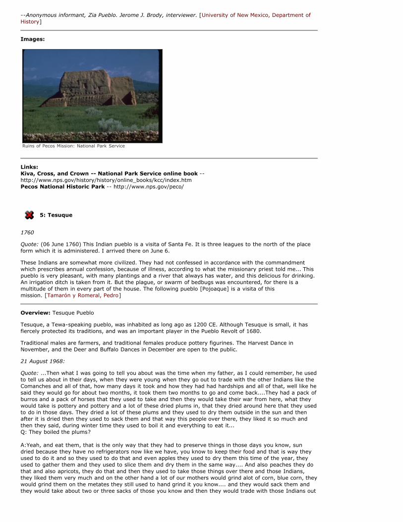
--Anonymous informant, Zia Pueblo. Jerome J. Brody, interviewer. [University of New Mexico, Department ofHistory]
Images:
Ruins of Pecos Mission: National Park Service
Links: Kiva, Cross, and Crown -- National Park Service online book --http://www.nps.gov/history/history/online_books/kcc/index.htmPecos National Historic Park -- http://www.nps.gov/peco/
5: Tesuque
1760
Quote: (06 June 1760) This Indian pueblo is a visita of Santa Fe. It is three leagues to the north of the placeform which it is administered. I arrived there on June 6.
These Indians are somewhat more civilized. They had not confessed in accordance with the commandmentwhich prescribes annual confession, because of illness, according to what the missionary priest told me... Thispueblo is very pleasant, with many plantings and a river that always has water, and this delicious for drinking.An irrigation ditch is taken from it. But the plague, or swarm of bedbugs was encountered, for there is amultitude of them in every part of the house. The following pueblo [Pojoaque] is a visita of thismission. [Tamarón y Romeral, Pedro]
Overview: Tesuque Pueblo
Tesuque, a Tewa-speaking pueblo, was inhabited as long ago as 1200 CE. Although Tesuque is small, it hasfiercely protected its traditions, and was an important player in the Pueblo Revolt of 1680.
Traditional males are farmers, and traditional females produce pottery figurines. The Harvest Dance inNovember, and the Deer and Buffalo Dances in December are open to the public.
21 August 1968:
Quote: ...Then what I was going to tell you about was the time when my father, as I could remember, he usedto tell us about in their days, when they were young when they go out to trade with the other Indians like theComanches and all of that, how many days it took and how they had had hardships and all of that, well like hesaid they would go for about two months, it took them two months to go and come back....They had a pack ofburros and a pack of horses that they used to take and then they would take their war from here, what theywould take is pottery and pottery and a lot of these dried plums in, that they dried around here that they usedto do in those days. They dried a lot of these plums and they used to dry them outside in the sun and thenafter it is dried then they used to sack them and that way this people over there, they liked it so much andthen they said, during winter time they used to boil it and everything to eat it... Q: They boiled the plums?
A:Yeah, and eat them, that is the only way that they had to preserve things in those days you know, sundried because they have no refrigerators now like we have, you know to keep their food and that is way theyused to do it and so they used to do that and even apples they used to dry them this time of the year, theyused to gather them and they used to slice them and dry them in the same way.... And also peaches they dothat and also apricots, they do that and then they used to take those things over there and those Indians,they liked them very much and on the other hand a lot of our mothers would grind alot of corn, blue corn, theywould grind them on the metates they still used to hand grind it you know.... and they would sack them andthey would take about two or three sacks of those you know and then they would trade with those Indians out

there, even bread, that they baked in the oven, and what they used to do was, they used to make them realcrispy, that is what they said, they used to make them real crispy because that is the kind that those Indianslike and they used to take them and when they get over there, they used to...they know that they are comingand they used to go in a bunch, see they would invite those San Ildefonso and Santa Clara so many wouldcome here and join them and together they used to travel.
Q: In a bunch, the Comanches, and who else did they trade with now? Did they trade with the Navajo at all? A: No, they never did trade with the Navajos. I think the Navajos were their enemies and... Q: And the Apaches too? A: Yeah, the Apaches too, and they were almost their enemies but I think those Comanches and those Utes... Q: They traded with the Utes?
A: Yes, they traded with the Utes, yeah, with them too and then when they get over there, they know thatthey are coming and those people would get excited and they used to go in bunches and they would say,tewas are coming, tewas are coming, tewas they used to call them.... Tewas are coming and then you oughtto see the kids, how they used to run, get excited and then there, they would welcome also, then pretty soona lot of them would come around, boy, they would trade their wares, like they did a lot of beadwork you seeand moccasins and beaded moccasins and them sometimes they would offer you just a plain buckskin youknow and then shawls that they made their own and also chaps, and then some feathers, warbonnets and allthose things.
That's how they used to trade and so much they that is the way that they used to trade and so they wouldprice their things whatever they had and they would price them and that is how they trade, even trade, andthen not only that but they used to go, maybe after they come back them bring a whole bunch of things likethat and then at the same time, well they in certain months they used to go out and hunt buffalos and theyused to use certain men, they were experts. ...And they used to use spears.... and I guess once in a whilethey would use bow and arrows and you know but usually they used spears, that is how they were driving on ahorse and then they would spear the back of the buffalon on the side you know and they tried to get as closeas they can you know, that way they hit them right in the right place.
...I guess they used to have war with these Navajos I guess, that they were the ones that used to comearound like the raiders I guess, and we could see them and that is really true you know.... something like thatand they used to go along in different towns like that you see and they even came around the Pueblo... thePueblos. Q: Did they every come around this Pueblo? The Navajos, they raided here at Tesuque? A: Yeah, they did... and that is how, then when in those days the Indians always used to gather together andthey wernt to war and that is how it happened and the last war that they had with the Navajos was in Jemez,and that was the last time they attacked us....
Q: And I would also like to know too, where your people came from in the beginning and so forth, I mean didthey come down... A: I think that they say that we came mostly from Puye...Puye people. You see maybe we are sort of dividedamong those people you see... so much of it has living here into little pueblo you know, groups I think that iswhy we came from there, otherwise we wouldn't know where else we would come because in those dayspeople were so small, and then you know, you can imagine how small their houses were, those houses weresmall too, cause the rooms were small too...--Mr. & Mrs. Manuel Vigil; interviewer M. Husband. [University of New Mexico, Department of History]
Images:
Tesuque Pueblo 1973
Links: Indian Pueblo Cultural Center: Tesuque Pueblo -- http://www.indianpueblo.org/19pueblos/tesuque.html

6: Santa Cruz de la Cañada
1760
Quote: (1760) The villa of Santa Cruz de la Cañada is two leagues from san Juan to the east. ...The followingmissionary parish priests presented themselves here: Fray Juan Jose de Toledo of the pueblo of Santo Tomasde Abiquiu, 50 years old, who has served in those missions for a long time; and his mission is ten leaguesnorth northwest of La Canada, upstream and on the other side of the river. And the mission parish priest ofthe pueblo of Santa Clara, which is two leagues from La Canada but is on the other side of the river. I desiredto go there. They did not permit it because of the height of the river and the poor condition of the canoe. Thegenizaros of Abiquiu, Santa Clara, and Ojo Caliente were confirmed at La Canada. ... In the Abiquiu books Ifound a guide to confession and catechism in the Tewa and Spanish languages, upon which I admonished thefathers, bu they replied they did not agree with it and that it was useless. [Tamarón y Romeral, Pedro]
Overview: Santa Cruz de la Cañada
The Santa Cruz River valley was the site of over thirty prehistoric settlements, and at the time of Oñate'sentrada, was still populated with Tewa-speaking Puebloans, as he noted by calling it "La Cañada de losTeguas." A few Hispanic settlers moved into the valley they called "La Cañada," but fled to Santa Fe during theRevolt of 1680.
After the Reconquest, the Spanish found that Tano-speaking Puebloans from San Lazaro and San Cristobalhad populated this valley, and Governor de Vargas began a campaign to resettle them around Chimayo,prompting a second revolt, in 1696. Vargas crushed the rebellion, and the remaining Puebloans fled to Hopi,becoming the Hopi-Tewa.
Vargas then resettled the valley with Spanish settlers, and designated a villa-- one of only three in colonialNew Mexico-- La Villa Nueva de Santa Cruz de Españoles Mexicanos del Rey Nuestro Señor Don CarlosSegundo (The New Villa of Santa Cruz of Mexican Spaniards under the King Our Lord Carlos II).
In 1779, Governor de Anza required the settlers to cluster their homes around a plaza for security, and theplaza still partially exists today. By 1790, over 7000 Spanish residents filled the valley.
Santa Cruz de la Cañada has been at the heart of other conflicts, including an 1847 battle between the rebelswho killed Governor Bent and troops under Colonel Sterling Price.
The church remains today as a fine example of colonial architecture, boasting stunning examples of 17th and18th century folk art.
Images:
Links: Office of the State Historian: Santa Cruz de la Cañada --http://www.newmexicohistory.org/filedetails_docs.php?fileID=504
7: Trampas
1760
Quote: (1760) Afterwards we reached the Truchas pass, which is already in the sierra. ...
At about eleven oclock in the morning, when we were enduring great heat, we encountered a beautiful littlespring of spouting water, from which we drank. It was like snow water and very thin. A midday stop was madeat the site of Trampas, where there are some settlers. License to build a church was left for them. this license

was also drawn up to provide that the church should be inside their walled tenement and that it should bethirty varas long including the transept. [Tamarón y Romeral, Pedro]
Overview: Las Trampas
First settled in 1751 by 12 Spanish families from Santa Fe, Las Trampas flourished despite Commanche andApache raids. The village, a Spanish-American agricultural community, preserves significant elements of its18th-century heritage in appearance and culture.
The San José de Gracia church dates from between 1760-1766, and was once used by Los HermanosPenitentes, a flagellant order.
8: Picuris
1760
Quote: (1760) A Franciscan missionary resides in this Indian pueblo, the patron saint of which is San Lorenzo.And before reaching it, one crosses a valley they call Chimay, which is traversed by a river. These peoplecame out to receive me. They have good irrigated lands.
... The two rivers of Santa Barbara and Picuris were crossed by bridges. they are very rapid and were carryinga great deal of water.
...The Indians in this pueblo do not confess except when they are dying, and even the interpreters are thesame. Here I labored all I could with the inerpreters so that they might inspire the others to contrition. As aresult one interepreter and a few others confessed, and the father missionary was charged to carry this workforward. [Tamarón y Romeral, Pedro]
Overview: Picuris Pueblo
The Picuris, Tiwa-speaking puebloans, have occupied this site since around CE 850. Castaño de Sosa was thefirst European to describe it, in 1583. The Picuris earned heavy punishment from the Spanish for their role inthe Pueblo Revolt, and after the Reconquest, the pueblo was abandoned, and the Picuris took refuge with thePlains tribes. Picuris was resettled in the early 1700s, and the San Lorenzo de Picurís mission was built. Today,Picuris has over 300 members, and visitors can learn more about their culture at the Picuris visitor center andmuseum.
26 November 1968:
Quote: I don't know what Indians they [Rael's grandparents] used to trade with, they used to bring a lot ofthings to trade. And then they used to do the same thing, they used to take, they used to take buffalo meatyou know, they used, all of these, they used to have a lot of buffalo meat and they used to trade that andbecause they used to do quite a bit of farming, they used to raise quite a bit of corn. That was what they usedto raise more and they used to take corn, they used to go down west and east or south, but anyway theyused to go out and...
Q: So they were trading both with the southern pueblos and with the plains people? A: Yeah, yeah! And the Apaches used to live quite a bit around. Q: Well the Picuris and the Apaches used to get along very well? A: Oh yeah! Q: Now, which Apaches were they, these were the Jicarilla? A: Yeah, the Jicarilla. And I understand they even came clear back in here you know, yeah. They do haveshrines here on the reservation, they come and, still come and visit.... But I do remember that they used tohave a lot of stories about the fighting with [the Arapahoes]. The last time that they got the scouts, you knowall the tribes have scouts. Like Picuris used to have scouts that went north, way far.East the same way, andthey said that this was the tribe I finished telling you about, the Arapahoes. There were three and they gotthem, the Picuris catch them. And they scalped them, they scalped them and I remember seeing those scalpswhen I was a little boy. And they used to have a certain celebration you know, they used to have some doingsyou know, every year at the same time..... They used to send scouts you see, to watch, and then go back andgive the report and the rest of the band would proceed. A: And then they caught these three? they were scouts? Q: They were scouts. So they didn't go back...--Alfredo Rael, Governor of Picuris Pueblo. Interviewer: Lonnie C Pippin. [University of New Mexico,Department of History]
Links: Picuris Pueblo official website -- http://www.picurispueblo.netNew Mexico Tourism: Picuris -- http://www.newmexico.org/native_america/pueblos/picuris.php

9: Apaches
1760
Quote: The titular patron of this Indian pueblo is San Jerónimo. To reach it we traveled through pine forestsand mountains until we descended to the spacious and beautiful valley they call the valley of Taos. In thisvalley we kept finding encampments of peaceful infidel Apache Indians, who have sought the protection of theSpaniards so that they may defend them from the Comanches. Then we came to a river called Trampas, whichcarries enough water. The midday halt was made at the large house of a wealthy Taos Indian, very civilizedand well-to-do. The said house is well walled in, with arms and towers for defense. [Tamarón y Romeral,Pedro]
Overview: Jicarilla Apache
The Jicarilla occupied much of the area of New Mexico north and east of Santa Fe, as well as a portion ofsouthern Colorado. As is the case with other tribal home territories, especially those relying on a hunting andgathering economy, traditional lands were also used by other tribes who shared a similar lifestyle. In historictimes, the traditional lands of the Jicarilla described here were also used by various bands of Utes, as well asby other tribes who passed through the area. Increasing pressures from non- Indian settlers from the east andthe movement of tribal groups from the Rocky Mountain area brought incursions of additional tribal groupsinto the area, such as the Comanche.
The Jicarilla practiced a mixed economy, but still relied primarily on hunting and gathering. With the tribalhomeland in close proximity to the Great Plains, the Jicarilla hunted the buffalo and were in contact with otherGreat Plains tribes who passed through the mountain passes to trade and hunt. Agriculture complemented theJicarilla hunting practices, and when the Spanish arrived in the area, the Jicarilla were described as living inflat - roofed houses or rancherías. [Long Distance Trails Group--Santa Fe, National Park Service, New MexicoState Office, Bureau of Land Management]
03 June 1970:
Quote: If I speak English I stumble too much on my words. We Apaches are an unknown people with afragmented history. Some parts are all right....
Long ago there were no stores. We lived off the land. We had shoes and clothes. We were not cold. Even thenno one was hungry. It was the whiteman who shut off our food supply. They cut off our supply by destroying--they cut trees. We lived by the trees, we used it for clothing, coloring, and medicine. In the spring food isplentiful. We begin to go with the sun. We go in its direction toward the seasons, like towards there is nosnow. We move around where the weather is best with our horses.
We move where the buffalos are. We kill it for shelter, our home, our bedding. Its meat is dried. Every part ofthe buffalo is put to good use. Nothing is thrown away. We depended on the buffalo. This is how we lived. Ourenemies (mostly Plains Indians but others too) fought with us. They shot us and we shot back. Or enemieswere scared of us. They gained up on us. We got the best of them. We had arrows that they were scared of.Back in our country we put a type of fat on the arrows. When this arrow is shot the receiver of the arrow diesfrom the swelling. They were afraid of us. They would gather up many parties of Indians and wait around forus. They never got us. They couldn't get us. We got the best of them. We lived like men with many powers,that is why. We lived with nature as our guide. The birds would call from a certain direction and we wouldmove in that direction. During the winter we moved into the tall woods. Our food was there but we had to lookfor it. The deer were in the woods for us, just as the birds we there if we should need them for food. I twasmade that way for us and we did not forget it. This is how we lived. During the times when food becomesscarce we will know (our children and grandchildren because we told them) how to survive. Our children willlearn to read and write but they will still know how to survive. There are many things to eat. It growseverywhere. it's like it is growing into your mouth, it used to be. The people are their own enemies. Somepeople aren't people. Some people aren't even very smart. They steal cattle, that is why we acquired enemies.They stole horses from us in turn. We continued to be enemies because of it. They would seek us out to fightwith us. They ganged up on us and we hid up in the mountains. They never killed us all. They would tell on uson the Army troops and with them they sided. They wanted to get us out into the plains and kill us off easily,but it didn't happen that way.
They gathered us. Our grandfathers prayed for us. From the "Gobierno" (Government --Washington DC) camesome officials. They became friends or they signed a treaty. They gathered us and send us down to the land ofthe Mescaleros. They said we were too much trouble, caused too much trouble, where we lived. We wentdown to Mescalero. We went down there where the people understood us. This is what the whitemen thought.They put us together about 1880. We were not quite used to the ways of the Mescaleros nor were we able tocompletely understand each other, language-wise. The language was similar but not similar enough. We weredown there for about 5 years. Our people got tired. Some men went to Gobierno. We were living with theMescaleros like children. Children play together all right for a while, but they soon begin to fight. This is how itwas. It was for reasons like these that we were unable to get along.
We soon separated with permission from the U.S Government but with children as "collateral" (for the price ofseparation our children were at stake). We came back to the area around Navajo River (Dulce). The

government helped us coming back. It was they who moved us down there. When we could not get along theybrought us back.
The men and the children had to go to school. They were to learn and help lead us. today we live by it, thechildren learned well. Many of them finished school and went on to good paying jobs. Many of them work likewhitemen. The whitemen are always on our backs for learning their ways. We don't depend on paper andbooks for our way of living. We use our heads to learn things. We use our heads to store the knowledge of thepast. The whiteman has short memories. They always need books to remind them but even then they neverremember it all....
We didn't keep records on paper....We counted the seasons. We knew what was happening. Even today mostof us still live by it. We still know it in older people. It isn't written anywhere except in our heads. We aren'tlike the whiteman. He has to mark it down somewhere in order to remember. We think and use our heads.Everything has a name, medicine, birds, everything. We knew all of them. We know their characteristics. Ifthey are dangerous we warn each other from it. There are always those who do not listen. If we tell themthere is a branch sticking out and they should be careful, they will run into it anyway causing them to go blind,but they have to learn from their mistakes.--Cevero Caramillo, age 77, Jicarilla Apache. Veronica Velarde, interviewer. Translated from JicarillaApache. [University of New Mexico, Department of History]
Quote: A: At night we used to go to the Bear dances. We were allowed to stay home and go to school fromthere. We went to school only in the morning. We went to school in our Bear dance attire since we weredancing at night. We went to school with ribbons in our hair. The white lady didn't say anything to us about it.
Q: Did you say you went to school from home [in La Jara]?
A: Yes. It was a day school.
Q: What sort of clothes did you wear? Were you giving clothes?
A: We dressed as Apache children. We wore long dresses with socks like these.
Q: Where did you get it?
A: From wherever possible. The school was very poor. We read old books.
Q: What did you read about?
A: I'm not sure. We wrote with black stones. We wrote our names. Virginia was always writing her name.Juanita was also writing her name. She told us she already knew and understood English. We didn't believeher. During Christmas we would go up into the hills and stand by the cliffs and sing. The whitelady said Godwas listening to us. She would be proud of us and give us presents. She said the presents were for God. Shesaid the presents were from God. We would sing even louder then. When we finished singing we would rundown the hill. Christmas she would give us dolls and boxes and little toys that looked like chickens. She gaveus toys. We would go home and return after New Years. I wondered what she meant by New Years. Some ofthose who understood thought they were better than we were. We used to eat lunch at school.
Q: Were there many Apaches going to this school?
A: Many Apaches were going to school there.
Q: Did they like it better?
A: Many people lived around there. There were many Apaches then. All ages went to school. The little childrenplayed separately....
Q: Did you go to school in Dulce first?
A: Yes, for about three or four years. I asked my father if he would put me in school there. I asked my motherto ask my father for me. He then took me over there. Norman stayed in Dulce, no, he was in [San Ildefonso],where his father was....He went to school among the puebols. He learned very well. The school ended. All thechildren got sick. Many Apaches died. They died from measles I think... This killed them. My family was notaffected. We moved far away into the canyon. We fled from the disease. Two years later we returned to schoolbut they told us there were hardly any children left to go to school besides the teachers were not getting paidenough. The school ended. Our people talked with them but could not get it back. The school ended. I neverwent back to school again. I didn't like it in Dulce. Later in 1914 I went back to school, I don't know what for.My sister died from me. She was going to school with me. I went to school for only a year after that. Theywanted me to come back to school. My father didn't want me to go any more.--Juanita Monarco, Jicarilla Apache, talks about her school days. [University of New Mexico, Department ofHistory]
Images:

Jicarilla Apache woman, boy and men seated inside a tepee, 1898
Links: Jicarilla Apache Nation -- http://jicarillaonline.com
10: Aviquiu
1754
Quote: (1754) The pueblo of Abiquiú was located at a place known as La Puente on a mesa on the south bankof the Chama, three miles southeast of the present town of Abiqwu. It was called Abechiu by the Indians,meaning the hooting of an owl. The Spanish town was founded prior to 1747. In the month of August of thatyear, it was attacked by the Yutas and the place was abandoned; a number of Spanish settlers were killed. Itwas re-settled not long afterward but the Indian attacks were so frequent that it was again abandoned. Thisarchive shows that it was re-occupied in 1754. In the latter part of the eighteenth century the pueblocontained 851 inhabitants and in 1794 it was inhabited in part by Genizaros, mostly from Hopi, whom theSpaniards had bought. In 1808, Abiquiú had about 2,000, only 122 of which, however, were Indians, theothers being Spaniards or of mixed blood. [Twitchell, Ralph Emerson]
Overview: Abiquiu
Today's village is built upon the prehistoric pueblo of Avéshu, abandoned in the 16th century for Santa Claraand Ohkay Owingue (San Juan). By 1744, the twenty families living in the area founded Santa Rosa de Limade Abiquiú just south of the present village, but had to be abandoned within a few years due to Ute andComanche raiding.
In an effort to resettle, Governor Tomás Vélez Capuchín awarded a land grant to thirty-four genízaro(Christianized Indians and mestizo) families, probably from around Santa Fe or Santa Cruz de la Cañada. Hecalled it San Tomas de Abiquiú, but the residents continued to honor Santa Rose de Lima.
After Governor de Anza made peace with the Comanche, Abiquiú became one of the larger villages in NewMexico, and enjoyed a short heyday as the last bastion of civilization for travelers on the Old Spanish Trail toCalifornia.
Today, Abiquiu is probably most known for being home to artist Georgia O'Keeffe, who lived at nearby GhostRanch from 1949 until her death in 1986.
Quote: My only regret about dying is not being able to see this beautiful country anymore, unless the Indiansare right and my spirit will walk here long after I am gone...--Georgia O'Keeffe
Images:

Adobe houses in a village
Links: Abiquiu Community Portal -- http://www.digitalabiquiu.comPueblo de Abiquiú ? A Genízaro Community -- http://www.newmexicohistory.org/filedetails_docs.php?fileID=507
11: Xemes
1760
Quote: (1760) The titular patron of this pueblo of Indians who speak the Pecos language is San Diego. It isthree leagues north of Sia. It has a Franciscan missionary parish priest. There are 109 families, with 373persons. The difficulties with regard to confession and catechism continue. [Tamarón y Romeral, Pedro]
Overview: Jemez Pueblo
Jemez (from Ha'mish or Hae'mish, the Keresan name of the pueblo- Bandelier). A village on the north bank ofthe Jemez River, about 20 miles northwest of Bernalillo, New Mexico.
According to tradition the Jemez had their origin in the North, at a lagoon called Uabunatota (apparentlyidentical with the shipapulima and Cibobe of other pueblo tribes), whence they slowly drifted into the valleys ofthe upper tributaries of the Rio Jemez-- the Guadalupe and San Diego-- where they resided in a number ofvillages, and finally into the sandy valley of the Jemez proper, which they now occupy, their habitat beingbounded on the south by the range of the west division of the Rio Grande Keresan tribes-- the Sia and SantaAna.
Castañeda, the chronicler of Coronado's experience of 1541, speaks of 7 pueblos of the Jemez tribe in additionto 3 others in the province of Aguas Calientes, identified by Simpson with the Jemez Hot Springs region.
Espejo in 1583 also mentions that 7 villages were occupied by the Jemez, while in 1598 Oñate heard of 11 butsaw only 8.
...the Jemez were induced to abandon their pueblos one by one, until about the year 1622 they becameconsolidated into the two settlements of Gyusiwa and probably Astialakwa, mainly through the efforts of FrayMartin de Arvide. These pueblos are supposed to have been the seats of the missions of San Diego and SanJoseph, respectively, and both contained chapels probably from 1618.
Astialakwa was permanently abandoned prior to the Pueblo Revolt of 1680, but in the meantime anotherpueblo (probably Potoqua) seems to have been established, which became the mission of San Juan de losJemez.
About the middle of the 17th century the Jemez conspired with the Navajo against the Spaniards, but theoutbreak plotted was repressed by the hanging of 29 of the Jemez....
When Vargas came in 1692 the Jemez were found on the mesa in a large pueblo, but they were induced todescend and to promise the Spaniards their support.
The Jemez, however, failed to keep their word, but waged war during 1693 and 1694 against their Keresanneighbors on account of their fidelity to the Spaniards....In July 1694, he [Vargas] again went to Jemez with120 Spaniards and some allies from Santa Ana and Sia. The mesa was stormed, and after a desparateengagement, in with 84 natives were killed, the pueblo was captured. In the month following, Vargas (afterdestroying this village, another on a mesa some distance below, and one built by their Santo Domingo allies 3leagues north) returned to Santa Fe with 361 prisoners and a large quanity of stores.
From this time on, the only then existing pueblo of the Jemez reoccupied was San Diego, or Gyusiwa, which

was inhabited until 1696, when the second revolt occurred, the Indians killing their missionary and againfleeing to the mesas... but in June of the year mentioned they were repulsed by a small detachment ofSpaniards...
The defeated Jemez this time fled to the Navaho country, where they remained several years, finally returningto their former home and constructing the present village, called by them Walatoa, "Village of the Bear."
In 1728, 108 of the inhabitants died of pestilence. In 1782 Jemez was made a visita of the mission ofSia. [Hodge, Frederick Webb]
07 October 1971:
Quote: During the expansion of the American frontier the Indian was always in the way... they moved him outof the way, transported him away from his natural home ground... and on the way they made him forced himto forget his culture, he lost his language and his culture and what little he had left he practiced it, maybewherever he was moved to... and so they don't have all of what they had originally and just about everyIndian nation had a conflict with the American government one way or another, everybody had it. they lost, allof them lost a good bit of their land except the pueblos.
We never had any conflict with the American government because we were first under the care of the Spanishgovernment and then the Mexican government and then after the Mexican American War the GuadalupeHidalgo Treaty made it possible or kept the American government from doing what they did to other Indiantribes.
See, Guadalupe Hidalgo Treaty granted that we lived as we always have. The American Government does notinterfere with us... and because of our relationship with the Spanish for so long since 1600.. more or less, let'ssay, peacefully.... although there were some problems before 1680... after the revolt or after 1692 and verypossibly, let's say, 1700... there was relatively peace and little more understanding between the pueblos andthe Spanish... which again led to the pueblo peoples' displeasure of the Navajos or Apaches.... or even theKiowa and Comanche because those were nomadic Indian who raided the pueblos who the pueblos were thenforced to be in alliance with the Spanish. Therefore, the Spanish begin to live with the pueblos very closely asfar as the, getting equal voting rights... and everything about the pueblos and the Spanish was equal... a billwas passed at one time denying Indians to buy liquor but that bill said, but not the pueblo Indians that liveamong us, because they were equal to the Spanish.
And we were not considered Indians until 1912... pueblos because we had lived with the Spanish people calledthat, Barbarios... barbarians... and we were, pueblos, Indios de los Pueblos... Indians of the Towns. Therefore,you know our living styles were closer together... in fact it is proved that these two groups developed... youknow, this is what we have today, native food, what most people call "mexican food," which is a combinationof pueblo and Spanish.
....What we say also is that we benefitted by Spain losing some of their early battles you know, in Europe...because during all the English Spanish wars, you know they were so, all their attention was there and theymore or less neglected the colonies out here and that was our good luck because we almost converted theSpanish colonies to the pueblo life.
But this is the system that we both have you know when Mexico took over... you know... New Mexico life Iguess you can call it... and Mexico took over after the Spanish government was unable to do much in thisarea... and Mexican government took over and they didn't do any more than take administrative control.. andthings were status quo and I don't think they have brought about any improvements and I don't think thatthey took anything away either.
But these are things that was in favor of the pueblos the fact that Spain was involved in their wars inEurope,..and we were able to , you know, adjust our lives to live with the Spanish.--Joe Sando, Jemez. Margaret Szasz, interviewer. [University of New Mexico, Department of History]
Images:
Ruins of the Jemez Church of San Diego at Gyusiwa

Links: Office of State Historian: N Scott Momaday on Jemez --http://www.newmexicohistory.org/filedetails_docs.php?fileID=1608
About this Map
Map which Don Francisco Antonio Marín del Valle, Governor and Captain General of this kingdom ofNew Mexico, ordered drawn : 1758
Bernardo de Miera y Pacheco was perhaps the most prolific and important cartographer of New Spain. He isthe only map maker who warrants an individual chapter in Wheat's monumental and comprehensive, six-volume Mapping the Transpacific West. He was born in Burgos, Spain, 1713, emigrated to the Americas, andsettled El Paso in 1743. He served in five military campaigns including the late 1740s attempt by Fra JuanMenchero to resettle the Navajo near Mount Taylor, west of Albuquerque. Miera's later maps bear a strikingresemblance to Menchero's map prepared about that time.
In 1749, Miera prepared a map of the Rio Grande from El Paso to its confluence with the Rio Conchos. In 1754,Miera moved to Santa Fe, where Governor Marin del Valle commissioned him to prepare a new map of NewMexico requested by the viceroy in Mexico City. That map, dated 1758 became one of the most widely knownfrom the Spanish colonial period. in 1756, Miera was appointed Alcalde Mayor of Galisteo and Pecos.
Atlas Citation: [Eidenbach, Peter]
Map Credits: National Park Service, Washington, D.C.
TIMELINE: LA TIERRA ADENTRO
1696
Don Pedro Rodriguez Cubero becomes governor after De Vargas' term expires.
1699
The Keres who had fled from the pueblos of Cieneguilla, Santo Domingo and Cochiti after the reconquest builta new pueblo on a stream called Cubero. This vast plain in that vicinity is also known as the Cubero Plain andwas doubtles so named because of the visit of Cubero at this time; the pueblo was known as San Jose de laLaguna, later Laguna Pueblo.
1700-1701
Hopis from surrounding villages destroy Aguatuvi, a Christianized pueblo.
"In the last days or the year 1700, or in the beginning of 1701, the Moquis of the other pueblos fell upon theunsuspecting village at night. The men were mostly killed, stifled in their estufas, it is said; the women andchildren were dragged into captivity and the houses were burnt...since that time Ahua-Tuyba has belonged tothe class of ruined historic pueblos." (Bandelier)
1703
De Vargas returns, Cubero flees.
1704
De Vargas dies of a sudden illness & is buried in Santa Fe parish church. Don Juan Paez Hurtado becomesinterim governor.
1705 Don Francisco Cuervo y Valdez becomes governor, appointed by the viceroy Don Francisco Fernandez dela Cueva Enriquez, Duke of Alburquerque.
1706
Juan de Ulibarri crossed Colorado as far as the Arkansas Valley into Kiowa County.
Governor Cuervo founds San Francisco de Alburquerque with 30 familes, resettles Santa Maria de Galisteo(formerly Santa Cruz de Galisteo) with 14 Tanos families from Tesuque, moves some Tehua families toPojoaque, resettles Villa de La Cañada with 29 families.
Cuervo is ordered to rename Alburquerque to San Felipe de Alburquerque in honor of King Felipe V.

1707
Cuervo is replaced as governor by Don José Chacon Medina Salazar y Villaseñor, Marqués de la Penula, until1712.
Governor Chacon rebuilt the chapel at San Miguel, which had been sacked in the 1680 uprising
1712-1715
Governor Chacon is replaced by Don Juan Ignacio Flores Mogollon, who is later indicted of malfeasance while inoffice, but has by that point disappeared. War with the Navajos, discontent among the pueblos. The Utes &Taos at war.
1715
Captain Félix Martinez appointed by the viceroy to governor, puts Mogollon in jail for two years.
1716
Gov. Martinez brings war against the Moquis, writes on Inscription Rock (El Morro) August 26, 1716.
1717
Martinez unwillingly replaced by Captain Antonio Valverde y Cosio, must be compelled to leave for Mexico City.
1719
Governor Antonio Valverde y Cosio leads a fairly bloody campaign against the Comanches; explores Coloradoas far as the Platte River, and explores Kansas. Learns of French/ Pawnee/ Jumano conflict with the Apaches.Ordered by the viceory to establish a presidio in Quartelejo (Cuartelejo) currently Beaver Creek, Scott County,KS to prevent the French from trading with Comanches.
1720
Pedro de Villasu explored Colorado and Nebraska.
1722
Don Juan Domingo de Bustamante sworn in as governor (acts until 1731). A convention of religious andsecular leaders investigates causes of lack of settlements between Alburquerque - Chihuahua, and cites bothpoverty, and persistent attacks by local tribes; the report recommends starting a presidio at with Socorro 50soldiers and 200 settlers.
1723
An investigation by the Viceroy reveals illegal trade in New Mexico with the French, in violation of the King'sorder prohibiting trade with French from Louisiana. Gov. Bustamante mandates trade with Plains tribes only inTaos or Pecos.
1727
French take Cuartelejo (in Kansas, see above).
1730
Bishop of Durango Benito Crespo makes a visita to New Mexico.
1731
Governor Bustamante is tried on charges of illegal trade (trading with the French) found guilty, and made topay the costs of his trial. Charges brought by Padre José Antonio Guerrero against the governor that the theIndians were forced to work without pay.
Fray Juan Miguel Menchero comes to New Mexico as visitador.
Gervasio Cruzat y Góngora succeeds Bustamante. He founds a mission among the Jicarilla and serves until1736.
1736
Don Enrique de Olavide y Micheleña takes over as governor, serves until 1739.
1737
Bishop of Durango Martin de Elizacochea makes a visita and carves his name on Inscription Rock.
1739
Don Gaspar Domingo de Mendoza becomes governor and serves until 1743.

Some Frenchmen come from Louisiana and settle in a place called Cañada near Isleta; Louis Marie Colons shotfor his crimes, Jean d'Alay becomes a barber in Santa Fe, and marries a New Mexican woman. Tomé foundedby 30 settlers.
1742
After the Rebellion of 1680, Sandia having been burned by the Spaniards, the inhabitants fled to the Hopicountry where they built the village of Payupki. In 1742, during the rule of Codallos y Rabal, these refugeeswere brought back by the frayles Deglado and Pino. Fray Juan Menchero, affirmed that had had been engagedfor six years in missionary work with the Indians and had converted more than three hundred and fifty ofthem, all of whom he had brought from the Hopi province for the purpose of establishing a pueblo at the placecalled Sandia. When the new pueblo was established six years later, it was given the name of Nuestra Señorade Dolores de San Antonio de Sandia.
1743
Don Joaquin Codallos y Rabal becomes governor, serves until 1747, Colonel Francisco de la Rocha appointedbut declines to serve, Rabal continues until 1749.
1746
Don José de Escandón explores and settles Rio Grande with seven detachments of soldiers, establishes towns.
Father Juan M. Menchero founds a short-lived settlement of 400- 500 Navajo, at Cebolleta (date is also listedas 1749).
"All went well for a brief time, but in the spring of 1750 there was trouble, which Lieutenant-GovernorBernardo Antonio de Bustamante, with the vice-custodio, Padre Manuel de San Juan Nepomuceno de Trigo,went to investigate. Then the real state of affairs became apparent. Padre Menchero had been liberal with hisgifts, and still more so with promises of more; hence his success in bringing Navajós to Cebolleta. But theysaid they had not received half the gifts promised, and their present padres-- against whom they had nocomplaint-- were too poor to make any gifts at all." (Bancroft)
1747
Fr. Menchero travels New Mexico as visitador; on his tour he turns west from Jornada del Muerto, as far as theGila, then north to Acoma. Don Bernardo Miera y Pacheco serves with Menchero. Thirty-three Frenchmencome to Rio de Jicarilla & sell firearms to the Comanches.
1749
Nuesta Señora de Santa Ana de Camargo (modern Camargo, Tamaulipas, west of McAllen, TX) founded at theconfluence of Rio San Juan & Rio Grande.
Don Tomás Velez Cachupin takes over as governor, serves until 1754.
Miera y Pacheco maps area around El Paso, down to La Junta del Rios.
1751
Governor Cachupin battles against the Comanches, gets a commendation from the Viceroy.
1755
Villa of Laredo founded.
1757
Don Bernardo Miera y Pacheco would accompany Gov Marín on his official tour of inspection and, at thegovernor's expense, he would map the entire province. From late June until December 1, 1757, they were inthe field. By the end of April 1758, Miera's elaborate map was ready.
1759
Presidio built at Junta de los Rios ( Texas).
1760
Governor Cachupin retires, mired in opposition by the Franciscans.
Don Francisco Antonio Marin del Valle succeeds him.
Bishop Tamarón of Durango makes a visita, and laments the state of affairs at the Pueblo missions,particularly that the priests could not speak the native languages and the Puebloans could not speak enoughSpanish to understand the doctrinal teachings.
Del Valle succeeded late in the year by Don Manuel Portillo Urrisola who governed until 1762.
1762

Governor Urrisola replaced by Cachupin again.
Cachupin makes search for mines into the Gunnison area of Colorado.
1765
Manuel de Rivera explored along what is now the Old Spanish Trail as far north as Delta, Colorado.
1767
Captain Pedro Fermín de Mendinueta, knight of Santiago succeeds Cachupin as governor. He asks for apresidio in Taos, and establishes a presidio at Robledo, consisting of 30 soldiers from Santa Fe.
1768-1776
Father Francisco Tomás Garcés explored Arizona, California, and the areas surrounding the Gila and Coloradorivers, While exploring the western Grand Canyon, he met the Hopi people and the Havasupai people . From1768 to 1776, Father Garces explored with Juan Bautista de Anza and alone with native guides.
1775
Juan Bautista de Anza and Francisco Tomás Garcés explored a route from the presido of Tubac, Arizona, wherede Anza was commander, overland to California. De Anza aalso founded the cities of Los Angeles, SanFrancisco, and San Jose.
1776 -1777
Fathers Silvestre Velez de Escalante and Francisco Domínguez along with 12 other men, form an expedition toattempt a route to Monterey from Santa Fe. They travel into Colorado, discover and name the Dolores River,north to Rangeley CO, then west into Utah, across the Wasatch Mountains through Spanish Fork Canyon, andto Utah Lake. That winter they traveled south as far as Cedar City before returning to Santa Fe, crossing theColorado River en route. They were the first Europeans in what is now Utah.
Visit Atlas of Historic NM Maps online at atlas.nmhum.org.
Website and Contents Copyright ©2008 - 2009 New Mexico Humanities Council. All rights reserved.


![Queen’s Gambit - Keres Defence (Baltic Defence) 1.d4 d5 2 ... [Keres Defence-1] Queen’s Gambit - Keres Defence (Baltic Defence) 1.d4 d5 2.c4 Bf5 10) 2.c4 Bf5 20) 2.c4 Bf5 3.Nf3WARNING✕Site](https://static.fdocuments.us/doc/165x107/5a788d417f8b9a7b698cab99/queens-gambit-keres-defence-baltic-defence-1d4-d5-2-keres-defence-1.jpg)
