Map Reading 101 - UConn CLEARclear.uconn.edu/lua/publications/basic/2012springMapReading101... ·...
40
5/4/12 Land Use Academy 1 Map Reading 101: Using and Reading Maps and Plans A Key Skill for Land Use Commissioners Paula Stahl, LLA, ASLA, AICP Land Use Educator Green Valley Institute
Transcript of Map Reading 101 - UConn CLEARclear.uconn.edu/lua/publications/basic/2012springMapReading101... ·...

5/4/12
Land Use Academy 1
Map Reading 101: Using and Reading Maps and Plans
A Key Skill for Land Use Commissioners
Paula Stahl, LLA, ASLA, AICP
Land Use Educator Green Valley Institute

5/4/12
Land Use Academy 2
How most of us react to maps and reports...
As the map is rolled out at
the P&Z meeting...
Wonder what those lines
mean?
Where is
this ?
I m hungry.
Oh, geeze I ll never get
home in time for the game
Goals of this Workshop
! " the sources of maps and plans
! " how maps and plans are used
! " fundamental elements of maps and plans
! " how to evaluate maps and plans
To Understand:

5/4/12
Land Use Academy 3
Maps, Plans...What s the Difference?
! " Maps show physical features of the natural or built environment at established scale and orientation.
! " Plans are engineered drawings made to scale showing existing physical features of a site and proposed changes to accommodate development.
What is the purpose of this Map or Plan?
! " Town Planning
! " Regulatory
! " Wetland Impacts (IWW)
! " Subdivision (Planning)
! " Site Plan (Zoning)
Maps, Plans...What s the Difference?
5/4/12
Land Use Academy 4
Go from the general to the specific
Maps, Plans...ways they are used
Maps are 2-dimensional representations of complex landscapes…
A Map is not the Territory… -Alford Korzybski
…at one point in time!

5/4/12
Land Use Academy 5
Key Elements of Maps
! " Identifiers
! " Legends
! " Scale
North Arrow For orientation purposes
Key Elements of Maps

5/4/12
Land Use Academy 6
Title Creation & Revision
Dates Source
Cartography Road Mapville, CT
XYZ GROUP/ ABC ASSOCIATES
500 Longitude Boulevard Mapville, Connecticut 06001 860-555-5555
Title Block Information on who/what/when etc
Key Elements of Maps
Legends Provide a guide to the symbols used
Key Elements of Maps

5/4/12
Land Use Academy 7
Scale Shows relative size of objects
Key Elements of Maps
35 20 !
Scale Shows relative size of objects Graphical Scale Written Scale
1:12,000 (ratio)
1 = 1,000 (equivalent)
Graphic scales are the most reliable!
Beware of Xerox Distortion
Key Elements of Maps
5/4/12
Land Use Academy 8
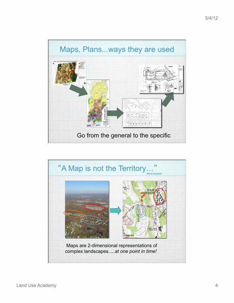
Measuring Distances
! " Rulers and Scales
Engineering Scale 1 = 10
1 = 20 1 = 30 1 = 40 1 = 50 1 = 60
1/8 = 1 1/4 = 1 1/2 = 1 3/4 = 1 1 = 1
Architects Scale
Map Scale Meaning
10 1 inch = 10 ft
20 1 inch = 20 ft
30 1 inch = 30 ft
40 1 inch = 40 ft
50 1 inch = 50 ft
60 1 inch = 60 ft
Measuring Distances ! " Engineering Scales 40 ft 240 ft 400 ft

5/4/12
Land Use Academy 9
But, can be used at other scales
Scale Meaning Adjustment
80 1 = 80 ft Use 40 scale and multiply by 2
100 1 = 100 ft Use 10 scale and add a zero
200 1 = 200 ft Use 20 scale and add a zero
2000 1 = 2000 ft Use 20 scale and add 2 zeros
Measuring Distances
Engineering Scales 400 X 2 = 800 ft X 2
Plan Scale Meaning
10 1 inch = 10 ft
20 1 inch = 20 ft
30 1 inch = 30 ft
40 1 inch = 40 ft
50 1 inch = 50 ft
60 1 inch = 60 ft
PLAN SCALE = 40
1 =40
Measuring Distances

5/4/12
Land Use Academy 10
1 =40
Measuring Distances
Distance ?
55
Factoid: What is an acre? 200
200
True acre 9% larger = 43,560 sq. ft. (R-1)
Builder s acre = 40,000 sq. ft (R-40)

5/4/12
Land Use Academy 11
Wonder what those lines
mean?
Map Reading Skills
Maps
Many maps are in the form of topographical maps aka topo
Interpreting a 3D world in 2D

5/4/12
Land Use Academy 12
Topography
Contour Interval is the difference between lines, USGS topo has 10 ft contours and site plans 2 ft contours
Index Contours are the lines labeled with an elevation
Contours: an imaginary line that connects points of equal elevation
Contours always connect, but not always within the map boundaries...
Topography
This could be the edge of a
presented map

5/4/12
Land Use Academy 13
Cross-sections are sometimes used to represent 3-D objects in 2 dimensions.
Topography
Cross-sections are sometimes used to represent 3-D objects in 2 dimensions.
Topography
Vertical scale sometimes exaggerated to better show change

5/4/12
Land Use Academy 14
every 5th contour is an index contour shown in bold
contours far apart show a gentle slope
contours close together show a steep slope
a series of concentric contours ending in a small closed circle or oval shows a local hilltop
contours at a stream form a V that always points uphill
contours very close together show a cliff
a spot elevation is a point of known elevation used as a pt of reference for surveys.
a benchmark (BM): point of known position & elevation used as a pt of reference for surveys.
green areas show forest cover; white areas denote fields
a contour interval is the vertical distance b/w contours. 10 on topos; 2-5 on site plans
contour lines of a ridge are in a U that always points downhill
Plan Reading - Tips
Water flows downhill...

5/4/12
Land Use Academy 15
Slope direction is calculated perpendicular to the contour lines.
Because … it is the steepest slope.
Topography
Water flows downhill...
Slope Change of elevation between two points, over a given distance…
Slope
Distance
Elev
atio
n

5/4/12
Land Use Academy 16
Slope
Percent Slope =
10 ft 20 ft
Change in Elevation Distance
X 100
(10 / 20 ) X 100 = 50% slope
Why is Slope Important? If too Steep:
- potential erosion
- soil stability
- safety
10 ft
20 ft

5/4/12
Land Use Academy 17
Why is Slope Important? If too flat:
- storm water may not drain
- may flood
0 ft
20 ft
Your turn!
Find or calculate the following: - What s missing? - Highest elevation - Elevation of Pt. A - The distance between Pts A & B - The change in elevation between A & B - The percent slope between A & B -" Which is higher C or D? -" Which direction would water flow from C? D? -" Where would that water leave the map edge?

5/4/12
Land Use Academy 18
Answers 1."-What s missing?
North Arrow, Legend, Source
2."-highest elevation
582 ft
3."-elevation of Pt. A 570 ft
4."-the distance between Pts A & B
1,000 ft
5."-the change in elevation between A & B
100 ft [B is 470] 6."- the percent slope between A & B
10% 100/1000 = .1
7."Which is higher C or D?
C [C is 510] 8."Which direction would water flow from C? D?
9."Where would that water leave the map edge?
As the map is rolled out at the P&Z meeting ...
Hmm. What are they doing?

5/4/12
Land Use Academy 19
Evaluating the Project
Site Development •" Land Clearing •" Grading •" Roads •" Structures
Management Plans •" Erosion & Sedimentation •" Stormwater
Land Clearing

5/4/12
Land Use Academy 20
Land Clearing
Limit of Construction Activity
Grading

5/4/12
Land Use Academy 21
Grading
Grading

5/4/12
Land Use Academy 22
Grading
Existing Contour Lines
More level when contours are farther apart
Grading
Existing Contour Lines
Proposed Contours

5/4/12
Land Use Academy 23
•" Type
•" Size
•" Location
Structures
•" Septic Systems
•" Wells
•" Roof leaders
•" Footing drains
Other Structures

5/4/12
Land Use Academy 24
Other Structures
Maps, Plans… What s the Difference?
! " Maps show physical features of the natural or built environment at established scale and orientation
! " Plans are engineered drawings, made to scale, showing existing physical features of a site and proposed changes to accommodate development.

5/4/12
Land Use Academy 25
Types of Plans
! " Survey – the site before proposed intervention
! " Layout – the proposed locations of added features
! " Grading & Drainage – changes to topography
! " Utilities – location/connection to systems
! " Demolition Plan – what s being torn down
! " Planting Plan – what plants where
! " Details – drawings of specific features at a large scale
! " Erosion and Sediment Control Plan – protection of the site and any wetlands during construction
TAKE IT APART & START ASKING
QUESTIONS
03/12/05
Plan Reading who? what? where? when?
Are they qualified?
What s the project name?
Where is it?
Where s north?
What s the scale?
Type of Map?
Who made the map? What s it all Mean?
When drawn?

5/4/12
Land Use Academy 26
Find the roads
Plan Reading – take it apart
and the sidewalks and centerline of road right-of-way
03/12/05
Plan Reading – take it apart
Property Line Stream
03/12/05

5/4/12
Land Use Academy 27
Plan Reading – take it apart
03/12/05
Plan Reading – take it apart
Topography
602+2
03/12/05

5/4/12
Land Use Academy 28
Plan Reading – take it apart
Topography
03/12/05
Plan Reading – take it apart
100-Yr Flood
03/12/05

5/4/12
Land Use Academy 29
Plan Reading – take it apart
Vegetation & Stonewalls
03/12/05
Plan Reading – take it apart
Utilities
03/12/05

5/4/12
Land Use Academy 30
03/12/05
Plan Reading
HP LP
– put it back together
Plan Reading – Who & Why
Zoning Commission: •" Establish zoning regulations •" Review site plans for adherence
Planning Commission: •" Plan of Conservation & Development •" Establish Subdivision regulations •" Review plans for subdivisions
Inland/Wetland Commission: •" Review site plans and subdivisions to determine
impact to wetlands

5/4/12
Land Use Academy 31
Plan Reading –
Why are you looking at these plans? There is a proposal to change this site
What s your role as a commissioner? To make sure this proposal meets the requirements set out by your commission's regulations
What s your goal? To ask as many questions as it takes
03/12/05
03/12/05
Plan Reading – Proposal
Is this a copy? Is that really the scale?

5/4/12
Land Use Academy 32
03/12/05
take it apart Plan Reading
03/12/05
take it apart Plan Reading

5/4/12
Land Use Academy 33
Plan Reading focus in
Plan Reading What s the lot size? Regulations: 1 ac.
Lot is 1.34 ac.
ask questions ……

5/4/12
Land Use Academy 34
Is that enough frontage? Regulations: 100 min.
122
40
Double Frontage
Plan Reading
Is the building within setbacks? Regulations: 40 front 10 side
27
46
131
Plan Reading

5/4/12
Land Use Academy 35
How many parking spaces?
9
4 5
8 8
2
Regulations: 41 + 2
34 + 2
Plan Reading
Where s the limit of wetland review?
Did Inland / Wetland Commission approve?
Plan Reading

5/4/12
Land Use Academy 36
What s the distance from the intersection? Regulations: 75
62
108
Plan Reading
Where s the dumpster?
Is it screened? Can it be accessed easily?
Plan Reading
5/4/12
Land Use Academy 37
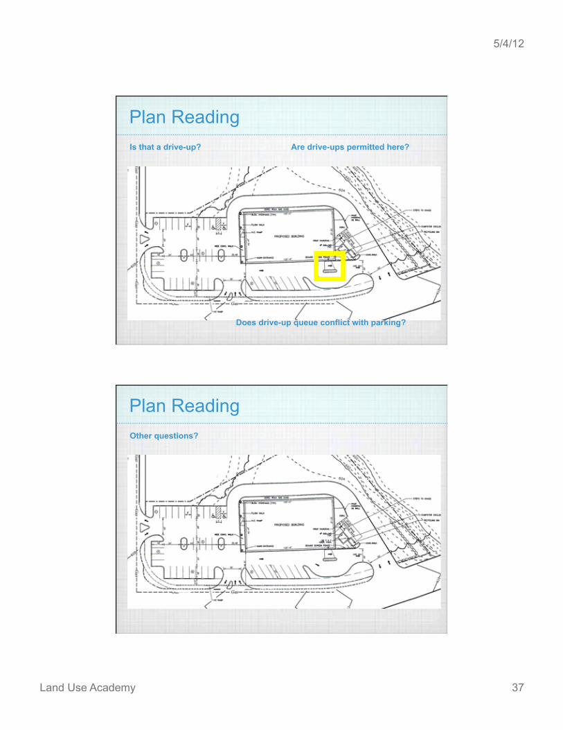
Is that a drive-up?
Does drive-up queue conflict with parking?
Are drive-ups permitted here?
Plan Reading
Other questions?
Plan Reading

5/4/12
Land Use Academy 38
Plan Reading – Another Proposal
Subdivision The division of a tract or parcel of land into three or more parts or lots for the purpose, whether
immediate or future, of sale or building development expressly excluding development for municipal, conservation or agricultural purposes
Plan Reading – Another Proposal
It s Your Turn Again !
5/4/12
Land Use Academy 39
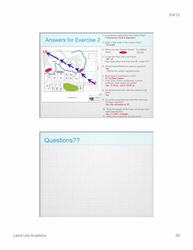
Answers for Exercise 2
LP
HP
1. Is anything missing from the Layout Plan? Professional Seal & Signature 2. What s the scale of the Layout Plan? 100 scale 3. Where are the steeper slopes? the flattest
area? 4. Locate the High and Low Points HP LP
How does water flow from the HP to the LP?
5. Would Inland/Wetlands need to approve? Yes Outline the upland regulated area. 6. What type of subdivision is this? R-1/2 Open Space 7. If an Open Space subdivision, is there
sufficient open space set aside? Yes 8.18 ac. out of 15.65 ac. 8. Do all proposed lots meet the minimum lot
size? Yes 9. Do all the proposed lots meet the minimum
frontage required? Yes, the narrowest is 78 10. Does the length of this new cul-de-sac road
meet regulations? Yes, it s 920 in length 11. What other questions do you have?
Questions??

5/4/12
Land Use Academy 40
Key Concepts: ! " Know the purpose of your map or plan
! " Remember: The map is not the territory. Verify with field walks, if necessary.
! " Always look for the significant map elements: north arrow, title blocks, legends, etc.
! " Always ask: what is the scale of this map? Is it appropriate for the purpose?
! " Try to visualize topography…use tricks when necessary.
! " The maps and plans are YOURS! Draw on them, make notes, anything that will help you formulate questions and understand the proposal.
! " If in doubt, ASK! If still in doubt, ask again!
The next time the map is rolled out at the P&Z
meeting...
What s the frontage?
Is that enough for
a sight line?
I think they re actually
reading my maps!
How steep is that
slope ?