UC Santa Cruz Tesla at Freedom SCIPP UC Santa Cruz UC Santa Cruz Tesla at Freedom E.S.
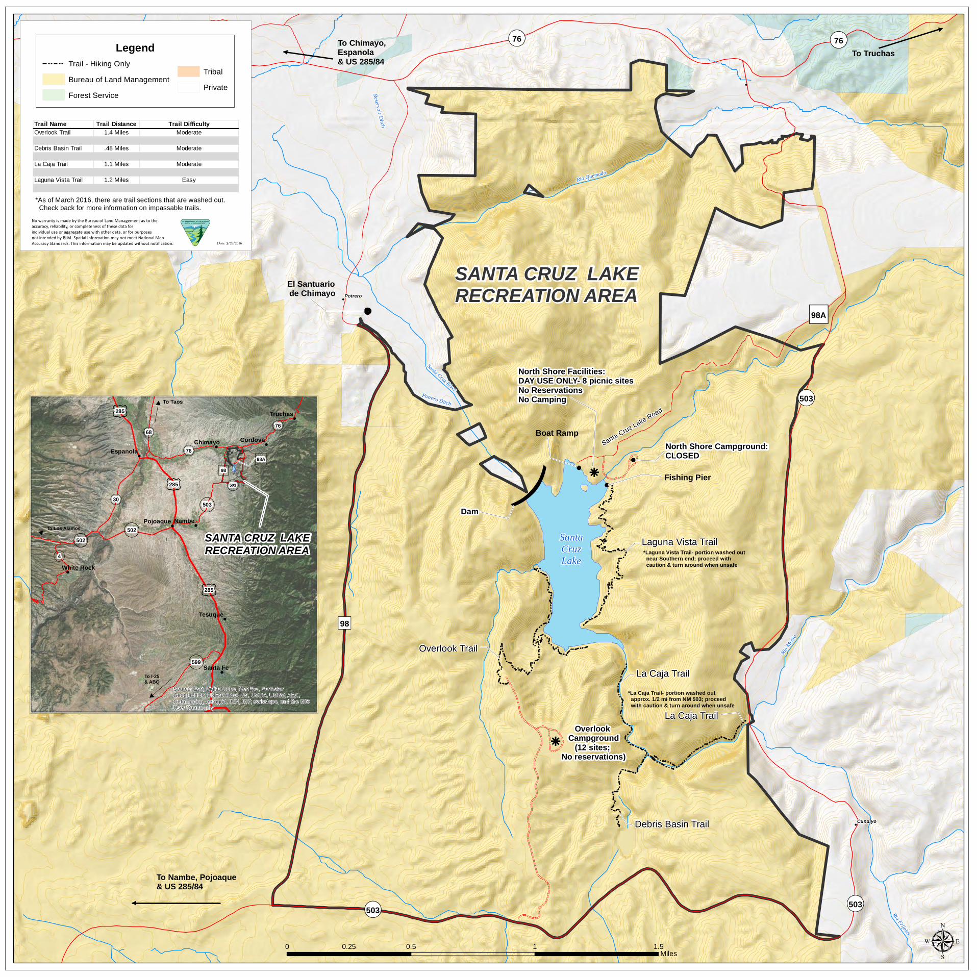
)SantaCruzLake
¬«503
¬«503
")98
Santa Cruz Lake Road
Overlook Trail
Debris Basin Trail
La Caja Trail
La Caja Trail
Laguna Vista Trail
")98A
*Laguna Vista Trail- portion washed out near Southern end; proceed with caution & turn around when unsafe
SANTA CRUZ LAKE RECREATION AREA
¬«503
¬« 76 ¬« 76
Cundiyo
Potrero
!
!
!
!
Santa Cruz River
Rio Quemado
Rio Medi
o
Reservoir Ditch
Potrero Ditch
Rio Frijoles
Arroyo d
e los E
ncinos
µ0 0.5 1 1.50.25Miles
No warranty is made by the Bureau of Land Management as to theaccuracy, reliability, or completeness of these data forindividual use or aggregate use with other data, or for purposesnot intended by BLM. Spatial information may not meet National MapAccuracy Standards. This information may be updated without notification. Date: 3/28/2016
LegendTribalPrivate
Bureau of Land ManagementForest Service
Trail - Hiking Only
Trail Name Trail Distance Trail DifficultyOverlook Trail 1.4 Miles Moderate
Debris Basin Trail .48 Miles Moderate
La Caja Trail 1.1 Miles Moderate
Laguna Vista Trail 1.2 Miles Easy
*As of March 2016, there are trail sections that are washed out. Check back for more information on impassable trails.
*La Caja Trail- portion washed out approx. 1/2 mi from NM 503; proceed with caution & turn around when unsafe
To Chimayo, Espanola& US 285/84
To Nambe, Pojoaque & US 285/84
To Truchas
!
!
Fishing Pier
Boat Ramp
!
North Shore Campground:CLOSED
k
North Shore Facilities: DAY USE ONLY- 8 picnic sitesNo ReservationsNo Camping
Dam
k
Overlook Campground
(12 sites; No reservations)
El Santuario de Chimayo
!
!
!
!
!!
!!
!
)98
(503
(503
(76
(76)98A
(502
(30
(4(502
¢285
(68
(599
¢285
¢285
To Los Alamos
To Taos
To I-25 & ABQ
SANTA CRUZ LAKERECREATION AREA
Nambe
CordovaChimayo
Truchas
Tesuque
Santa Fe
Pojoaque
Espanola
White Rock
Source: Esri, DigitalGlobe, GeoEye, EarthstarGeographics, CNES/Airbus DS, USDA, USGS, AEX,Getmapping, Aerogrid, IGN, IGP, swisstopo, and the GISUser Community