Map 1: North Berwick to Canty Bay - SCAPE · from the eastern end of Milsey Bay, North Berwick to...
50
42
Transcript of Map 1: North Berwick to Canty Bay - SCAPE · from the eastern end of Milsey Bay, North Berwick to...

42

Map 1: North Berwick to Canty Bay
This map section begins within the town of North Berwick and extends as far as the hamlet
of Canty Bay. Within North Berwick, much of the hinterland is developed, with housing and
roads and a promenade lying behind the coast edge. A golf course extends along the coast
from the eastern end of Milsey Bay, North Berwick to Horseshoe Point. In this area the
coastline is generally low lying. From Horseshoe Point, the coastline remains low, with hilly
ground now rising behind the coast edge. The coast edge throughout this area has been
classified as stable. Fourteen sites were identified within this area, all of which had been
recorded previously. Included here are the scheduled remains of St. Andrew's Church (EL65)
and several sites of apparent prehistoric date which are known only from past records: no
longer visible on the ground (EL75, EL76).
43
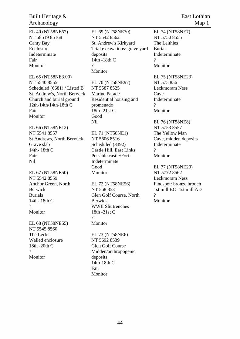
EL 40 (NT58NE57)NT 58519 85168Canty BayEnclosureIndeterminateFairMonitor
EL 65 (NT58NE3.00)NT 5540 8555Scheduled (6681) / Listed B St. Andrew's, North BerwickChurch and burial ground12th-14th/14th-18th CFairMonitor
EL 66 (NT58NE12)NT 5541 8557St Andrews, North BerwickGrave slab14th- 18th CFairNil
EL 67 (NT58NE50)NT 5542 8559Anchor Green, NorthBerwickBurials14th- 18th C?Monitor
EL 68 (NT58NE55)NT 5545 8560The LecksWalled enclosure18th -20th C?Monitor
EL 69 (NT58NE70)NT 5542 8562St. Andrew's KirkyardTrial excavations: grave yarddeposits14th -18th C?Monitor
EL 70 (NT58NE97)NT 5587 8525Marine ParadeResidential housing andpromenade18th- 21st CGoodNil
EL 71 (NT58NE1)NT 5606 8516Scheduled (3392)Castle Hill, East LinksPossible castle/FortIndeterminateGoodMonitor
EL 72 (NT58NE56)NT 568 853Glen Golf Course, NorthBerwickWWII Slit trenches18th -21st C?Monitor
EL 73 (NT58NE6)NT 5692 8539Glen Golf CourseMidden/anthropogenicdeposits14th-18th CFairMonitor
EL 74 (NT58NE7)NT 5750 8555The LeithiesBurialIndeterminate?Monitor
EL 75 (NT58NE23)NT 575 856Leckmoram NessCaveIndeterminate?Monitor
EL 76 (NT58NE8)NT 5753 8557The Yellow ManCave, midden depositsIndeterminate?Monitor
EL 77 (NT58NE20)NT 5772 8562Leckmoram NessFindspot: bronze brooch1st mill BC- 1st mill AD?Monitor
Built Heritage & East LothianArchaeology Map 1
44

Scale: 1:25,000Survey Date: Feb 2006
Crow
n cop
yrigh
t. All r
ights r
eserve
d. Hi
storic
Scotl
and L
icenc
e No.
1000
1750
9 [20
06]
c
Map 1East LothianBuilt Heritage &
Archaeology
Protected Ancient Monument orarea of Designated Wreck
Monument formally proposed byHistoric Scotland for scheduling orwreck for designation
Listed Historic Building
Undesignated wreck
Known ancient monument
Site found by this survey
Site complex
Built
Herita
ge &
Arch
aeolog
y
End of SurveyMap 2
EL40
EL71
EL70
EL65EL66EL67EL68EL69
EL74
EL72
EL75
EL73
EL77EL76
1 23
4
5 6 78 9 10 11
12131415
45

1. The SistersNT 5555 85450.8 kmRock PlatformCoast edge <5mDrift ?The foreshore in this section is characterisedby rock platform with some cobble andshingle cover. The hinterland is covered bydevelopment associated with the town ofNorth Berwick.
2. Milsey BayNT 5635 85191.0 kmMainly SandCoast edge <5mDriftThis section comprises Milsey Bay. Theforeshore is covered with sand for the mostpart. Occasional rocks protrude and rockplatform ocupies the central part of the bay.The hinterland is occupied by developmentassociated with North Berwick and a golfcourse. It is likely that much landscaping hastaken place on the golf course.
3. The LeithiesNT 5750 85592.3 kmRock PlatformCoast edge mostly >5mBlown SandThe coast here is characterised by rockplatform, which has some intermittent cobblecover, particularly in coves. The hinterland isoccupied by a golf course. It is likely thatmuch landscaping has taken place on the golfcourse.
Hinterland Geology & East LothianCoastal Geomorphology Map 1
46

Scale: 1:25,000Survey Date: Feb 2006
Crow
n cop
yrigh
t. All r
ights r
eserve
d. Hi
storic
Scotl
and L
icenc
e No.
1000
1750
9 [20
06]
c
Map 1East Lothian
Coastal GeomorphologyHinterland Geology &
Drift
Raised beach etc.
Glacial sand/gravel
Alluvium
Blown sand
Drift on visible rock
Hinte
rland
Rock platform
Mainly sand
Mainly alluvial/marine mud
Marsh
Fores
hore Low edge <5m
Cliff >5m
Man made barrier
Shingle/storm bank
Human disturbance
Modif
iers
1
2
3
1 23
4
5 6 78 9 10 11
12131415
47

1. Milsey BayNT 5600 85271.9 kmStableThe coast edge in this section is protected bysea walling associated with North Berwickroads and promenades. It is thereforedesignated as stable
2. Rugged KnowesNT 5685 85430.7 kmErodingThere is some limited erosion of the edge inthis area, which comprises steeply slopinghigh grassy slopes. The erosion appearshowever to derive from slippage of theoverlying turf and may not be caused bycoastal processes.
3. Leckmoram NessNT 5780 85601.7 kmStableThe coast edge in this section is generallystable and grassed over. Some erosion wasobserved on the edge however this is limitedin scale.
Erosion Class East LothianMap 1
48

Scale: 1:25,000Survey Date: Feb 2006
Crow
n cop
yrigh
t. All r
ights r
eserve
d. Hi
storic
Scotl
and L
icenc
e No.
1000
1750
9 [20
06]
c
Map 1Erosion Class
1
2
3
Definitely Eroding
Accreting or Stable
Definitely Accreting
Accreting and Eroding
Eroding or Stable
Stable
Land below 10mNo access
Erosi
on Cl
ass
East Lothian
1 23
4
5 6 78 9 10 11
12131415
49

50
Map 2: Canty Bay to Scoughall
This map section extends between the coastal hamlet of Canty Bay and Scoughall Farm.
From Canty bay to Auldhame there are high coastal cliffs. After a lower-lying section around
Auldhame, the coast edge again rises around Seacliff. Much of the coast edge is stable. The
exception is a section extending eastwards from Car Rocks. This is composed of soft
sandstone rock which is being eroded by wave action. Beyond Canty Bay, there is no modern
coastal settlement in this area; the hinterland comprises of arable and grazing land. A total of
thirty-one sites are identified here, of which seven were recorded for the first time by this
survey. The most spectacular site, Tantallon Castle (EL41), stands in an elevated position on
the cliff edge. It is a Property In Care and is open to visitors. The new sites recorded in this
area include two probable undeveloped landing places/harbours (EL61, EL64), a track
(EL42) and a navigation marker (EL46). One section, comprising of the beach beneath
Tantallon Castle, was not investigated by this survey because access was considered
hazardous.
51

EL 38 (NT58NE59)NT 5930 8525Gin Head, TantallonFormer NavalScientific ResearchEstablishment18th- 21st CGoodNil
EL 39 (NT58NE58)NT 59058 852310Gin HeadWWII Structure:Radar Station18th- 21st CGoodSurvey
EL 41 (NT58NE5.00)NT 5958 8502Sch (90295)/Listed ATantallonCastle & Dovecot14th-18th CFairMonitor
EL 42NT 59729 84703Oxroad BayTrackIndeterminateFairSurvey
EL 43NT 6029 8483The GeganHarbour18th- 21st CGoodNil
EL 44(NT68SW1/17)NT 6023 8462Scheduled (5605)Auldhame/ SeacliffLaird's House andmiddens14th- 18th CPoorSurvey
EL 45 (NT68SW7)NT 6045 8488St. Baldred's CaveCaveIndeterminatePoorSurvey
EL 46NT 6095 8516Great CarNavigation Marker18th- 21st CGoodMonitor
EL 47NT 61080 84365Car RocksPossible structuralremainsIndeterminateFairMonitor
EL 58 (NT68SW5)NT 61505 83633Scheduled (8744)Seacliff TowerTower house14th- 18th CPoorSurvey
EL 59 (seeNT68SW37)NT 6155 8357Scoughall RocksCoastal defence: seawall18th -21st CFairNil
EL 60NT 6155 8357Scoughall RocksBoundary wall18th -21st CPoorNil
EL 61NT 61568 83536Scoughall FarmPossibleslipway/harbourIndeterminateGoodNil
EL 62NT 61697 83408ScoughallCoastal defencesre-using WWIIanti-tank blocks18th- 21st CFairNil
EL 64NT 61011 84468AuldhamePossibleslipway/harbourIndeterminateFairNil
EL 78 (NT58NE130)NT 5864 8515Canty BayVillage18th- 21st CGoodNil
EL 79 (NT58NE60)NT 593 851CastletownField boundaryIndeterminateFairNil
EL 80 (NT58NE131)NT 5949 8516CastletonLanding placeIndeterminate?Monitor
EL 81 (NT58NE48)NT 5945 8509CastletonHarbourIndeterminatePoorMonitor
EL 82(NT58NE8001)NT 5973 8523TantallonShipwreck18th -21st C?Survey"
EL 83 (NT58SE70)NT 597 848Oxroad BayRock cut ditchIndeterminate?Monitor
EL 84 (NT58SE71)NT 599 848Oxroad BayCaveIndeterminateFairMonitor
EL 85 (NT68SW65)NT 6015 8478SeacliffDitchIndeterminate?Monitor
EL 86 (NT68SW3)NT 6030 8483The GeganStructural remainsand midden1st mill BC - 1st millADFair-poorMonitor
EL 87 (NT68SW30)NT 6016 8473AuldhamePossible promontoryfortIndeterminate?Monitor"
EL 88 (NT68SW8)NT 6123 8428Scheduled (8741)SeacliffMidden and cistburials1st mill BC- 1st millAD?Monitor
EL 89 (NT68SW12)NT 615 838ScoughallPossible site ofchapelIndeterminate?Monitor
EL 90(NT68SW8001)NT 618 844Scoughall RocksShipwreck18th -21st C?Survey
EL 91(NT68SW8019/8025)NT 62 84Scoughall RoadsShipwrecks18th -21st C?Survey
EL 92 (NT68SW8003etc)NT 617 835The Scoughall RocksShipwrecks18th -21st C?Survey
EL 165(NT68SW8015 etc)NT 610 845Car RocksShipwrecks18th- 21st C?Survey
Built Heritage & East LothianArchaeology Map 2
52

Map 2Built Heritage &Archaeology
Protected Ancient Monument orarea of Designated Wreck
Monument formally proposed byHistoric Scotland for scheduling orwreck for designation
Listed Historic Building
Undesignated wreck
Known ancient monument
Site found by this survey
Site complex
Built
Herita
ge &
Arch
aeolog
yScale: 1:25,000
Survey Date: Feb 2006
Crow
n cop
yrigh
t. All r
ights r
eserve
d. Hi
storic
Scotl
and L
icenc
e No.
1000
1750
9 [20
06]
c
Map 1
Map 3
EL39
EL42
EL58EL44
EL59,EL60,EL61
EL41
EL88
EL43EL83 EL47
EL92
EL80
EL46
EL87
EL62
EL82 EL64EL86
EL91
EL79
EL78
EL84
EL90
EL81
EL38
EL45EL165
EL85
EL89
East Lothian
1 23
4
5 6 78 9 10 11
12131415
53
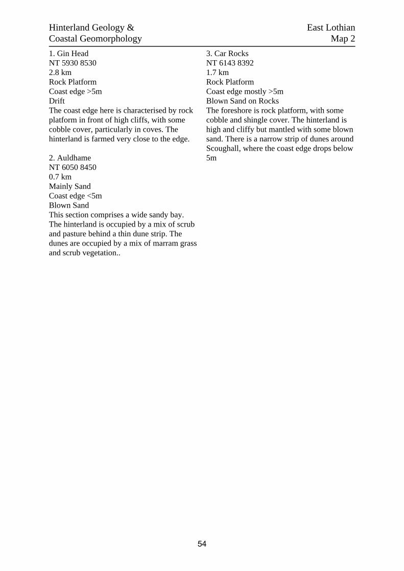
1. Gin HeadNT 5930 85302.8 kmRock PlatformCoast edge >5mDriftThe coast edge here is characterised by rockplatform in front of high cliffs, with somecobble cover, particularly in coves. Thehinterland is farmed very close to the edge.
2. AuldhameNT 6050 84500.7 kmMainly SandCoast edge <5mBlown SandThis section comprises a wide sandy bay.The hinterland is occupied by a mix of scruband pasture behind a thin dune strip. Thedunes are occupied by a mix of marram grassand scrub vegetation..
3. Car RocksNT 6143 83921.7 kmRock PlatformCoast edge mostly >5mBlown Sand on RocksThe foreshore is rock platform, with somecobble and shingle cover. The hinterland ishigh and cliffy but mantled with some blownsand. There is a narrow strip of dunes aroundScoughall, where the coast edge drops below5m
Hinterland Geology & East LothianCoastal Geomorphology Map 2
54

Scale: 1:25,000Survey Date: Feb 2006
Crow
n cop
yrigh
t. All r
ights r
eserve
d. Hi
storic
Scotl
and L
icenc
e No.
1000
1750
9 [20
06]
c
Map 2Coastal GeomorphologyHinterland Geology &
Drift
Raised beach etc.
Glacial sand/gravel
Alluvium
Blown sand
Drift on visible rock
Hinte
rland
Rock platform
Mainly sand
Mainly alluvial/marine mud
Marsh
Fores
hore Low edge <5m
Cliff >5m
Man made barrier
Shingle/storm bank
Human disturbance
Modif
iers
1
2
3
East Lothian
1 23
4
5 6 78 9 10 11
12131415
55

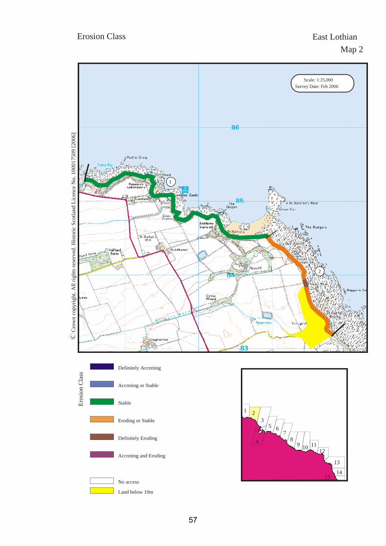
1. Gin HeadNT 6000 84803.5 kmStableThe coast edge in this section is for the mostpart very high vertical, or steeply sloping,cliffs, except to the east of Auldhame. Noerosion was observed.
2. Chapel BraeNT 6142 84001.7 kmEroding or StableThe coast edge in this section comprisesvertical stone cliff faces overlain by softersediments, which are grassed over. It appearsto be mostly stable, however the cliff facesshow signs of scouring by wave action.There is one area in particular, at NT 6146683904 (pic 95) where localised erosion hasrecently resulted in collapse of the cliff facetogether with overlying deposits.
The remains of a possible sea wall (see siteEL59) to the south of Chapel Brae lie now infront of the coast edge, indicating that thecoast is retreating in this area.
Erosion Class East LothianMap 2
56
Scale: 1:25,000Survey Date: Feb 2006
Crow
n cop
yrigh
t. All r
ights r
eserve
d. Hi
storic
Scotl
and L
icenc
e No.
1000
1750
9 [20
06]
c
Map 2Erosion Class
1
2
Definitely Eroding
Accreting or Stable
Definitely Accreting
Accreting and Eroding
Eroding or Stable
Stable
Land below 10mNo access
Erosi
on Cl
ass
East Lothian
1 23
4
5 6 78 9 10 11
12131415
57

58

Map 3: Scoughall to Links Wood
This map section extends from Scoughall Farm to Links Wood. Throughout this section the
coast edge is generally low lying and composed of sand dunes. Much of this section has been
classified as accreting and eroding, with deposits being removed from the foreshore and
deposited behind the coast edge. Within this dynamic system, the effects of erosion are not
uniform and some areas, such as around Peffer Burn, are more severely affected than others.
The Links Wood tree plantation, established in the 18th C, extends to the coast edge through
much of the south side of the headland of St. Baldred’s Cradle. In this area the degree of
erosion can be gauged from the many exposed tree roots and trees now situated within the
intertidal zone. A total of twenty-three sites are recorded here, of which one was found by
this survey. Many of the sites in this area represent WWII defences, these include trenches
(EL10), anti-tank blocks (EL1) and a pill-box (EL9). A probable prehistoric cairn (EL11) and
a possible fish trap (EL37) were also noted.
59

EL 1 (NT68SW44)NT 63303 81263Links WoodWWII anti-tank blocks &road block18th-21st CFairSurvey
EL 2 (NT68SW43)NT 63074 81342Bathan's StrandWWII anti-tank blocksand earthworks18th-21st CFairSurvey
EL 3 (see NT68SW42)NT 62048 82363Peffer Burn / LochhousesLinksWWII defences:anti-tank blocks18th-21st CFairSurvey
EL 4 (NT68SW39)NT 62014 82872Peffer Burn / ScoughallLinksWWII defences: pill-box18th-21st CFair/PoorSurvey
EL 5 (see NT68SW63)NT 62024 82922Peffer Sand/ ScoughallLinksWall, land boundary18th-21st CPoorNil
EL 6NT 62035 82566Peffer SandsEx-situ structuralremains: possibly WWII18th-21st CPoorNil
EL 7 (NT68SW62)NT 6280 8160Ravensheugh SandsWWII anti-tank blocks &structure18th-21st CPoorMonitor
EL 8 (NT68SW45)NT 63530 81222Whitberry PointWWII trenches &possible structuralremains18th-21st CPoorSurvey
EL 9 (NT68SW45)NT 63543 81254Bathan's Strand/St.Baldred's CradleStructural remains:possible WWII18th-21st CFair/PoorSurvey
EL 10 (NT68SW45/22)NT 63560 81259Bathan's Strand/St.Baldred's CradleWWII defences: trenches18th-21st CFairSurvey
EL 11 (NT68SW4/4.1)NT 6371 8125St. Baldred's CradleCairn3rd-1st mill BCFairMonitor
EL 12 (NT68SW61)NT 6380 8130St. Baldred's CradleViewing seat18th-21st CGoodNil
EL 13NT 63647 81166Links WoodWWII anti-tank blocks18th-21st CPoorNil
EL 14 (NT68SW46)NT 63567 80862Links WoodWWII Structure: pill box18th-21st CGoodSurvey
EL 15 (NT68SW49)NT 63455 80825Links WoodWWII anti-tank blocksand road block18th-21st CGoodSurvey
EL 37 (NT68SW47)NT 63602 80795Tyne SandsPossible Fish TrapIndeterminateFairSurvey
EL 63 (NT68SW38)NT 61704 83325ScoughallWWII anti-tank blocks18th -21st CFairNil
EL 93 (NT68SW8006)NT 6205 8263Scoughall LinksShipwreck18th -21st C?Survey
EL 94 (NT68SW8020etc)NT 622 825Peffer SandsShipwrecks18th -21st C?Survey
EL 95 (NT68SW41)NT 626 818Ravensheugh SandsWalls18th- 21st C?Nil
EL 96 (NT68SW42)NT 6260 8180Ravensheugh SandsWWII defences: trenches18th- 21st CFairNil
EL 98 (NT68SW59)NT 6305 8151Bathan's StrandIndeterminateIndeterminate??
EL 99 (NT68SW57)NT 6355 8080Tyningham, Links WoodFindspot: arrowhead3rd- 1st Mill BC??
EL 100 (NT68SW48)NT 635 806Tyne SandsTrack18th- 21st CFairNil
EL 101 (NT68SW60)NT 6345 8078Tyne SandsSea defenceIndeterminate?Monitor
EL 102 (NT67NW78)NT 635 797Sandy HirstWWII defences: trenches18th -21st C?Survey
Built Heritage & East LothianArchaeology Map 3
60

Scale: 1:25,000Survey Date: Feb 2006
Crow
n cop
yrigh
t. All r
ights r
eserve
d. Hi
storic
Scotl
and L
icenc
e No.
1000
1750
9 [20
06]
c
Map 3Built Heritage &Archaeology
Protected Ancient Monument orarea of Designated Wreck
Monument formally proposed byHistoric Scotland for scheduling orwreck for designation
Listed Historic Building
Undesignated wreck
Known ancient monument
Site found by this survey
Site complex
Built
Herita
ge &
Arch
aeolog
yMap 2
Map 4
EL63
EL15EL14, EL37, EL99
EL95, EL96 EL9, EL10
EL100
EL3
EL98
EL101
EL94
EL13EL1
EL6EL93
EL2
EL11
EL5
EL12
EL4
EL7
EL8
East Lothian
1 23
4
5 6 78 9 10 11
12131415
61

1. ScoughallNT 6187 83120.4 kmRock PlatformCoast edge <5mBlown SandThe foreshore is rock platform, with somecobble and shingle cover. There is a narrowstrip of dunes around Scoughall.
2. Ravensheugh SandsNT 6261 81802.4 kmMostly SandCoast edge <5mBlown SandA long sandy foreshore with a dune strip atthe coast edge. The dunes reach over 5m inheight away from the edge and are coveredby marram grass.
3. St. Baldred’s CradleNT 6363 81121.4 kmRock PlatformCoast edge <5mBlown SandThe foreshore around St. baldred’s Cradle isrocky, with some cobble cover. Thehinterland is blown sand, occupied bywoodland for the most part. The peninsula ofSt. Baldred’s Cradle is covered by roughgrass.
Hinterland Geology & East LothianCoastal Geomorphology Map 3
62

Scale: 1:25,000Survey Date: Feb 2006
Crow
n cop
yrigh
t. All r
ights r
eserve
d. Hi
storic
Scotl
and L
icenc
e No.
1000
1750
9 [20
06]
c
Map 3Coastal GeomorphologyHinterland Geology &
Drift
Raised beach etc.
Glacial sand/gravel
Alluvium
Blown sand
Drift on visible rock
Hinte
rland
Rock platform
Mainly sand
Mainly alluvial/marine mud
Marsh
Fores
hore Low edge <5m
Cliff >5m
Man made barrier
Shingle/storm bank
Human disturbance
Modif
iers
1
2
3
East Lothian
1 23
4
5 6 78 9 10 11
12131415
63
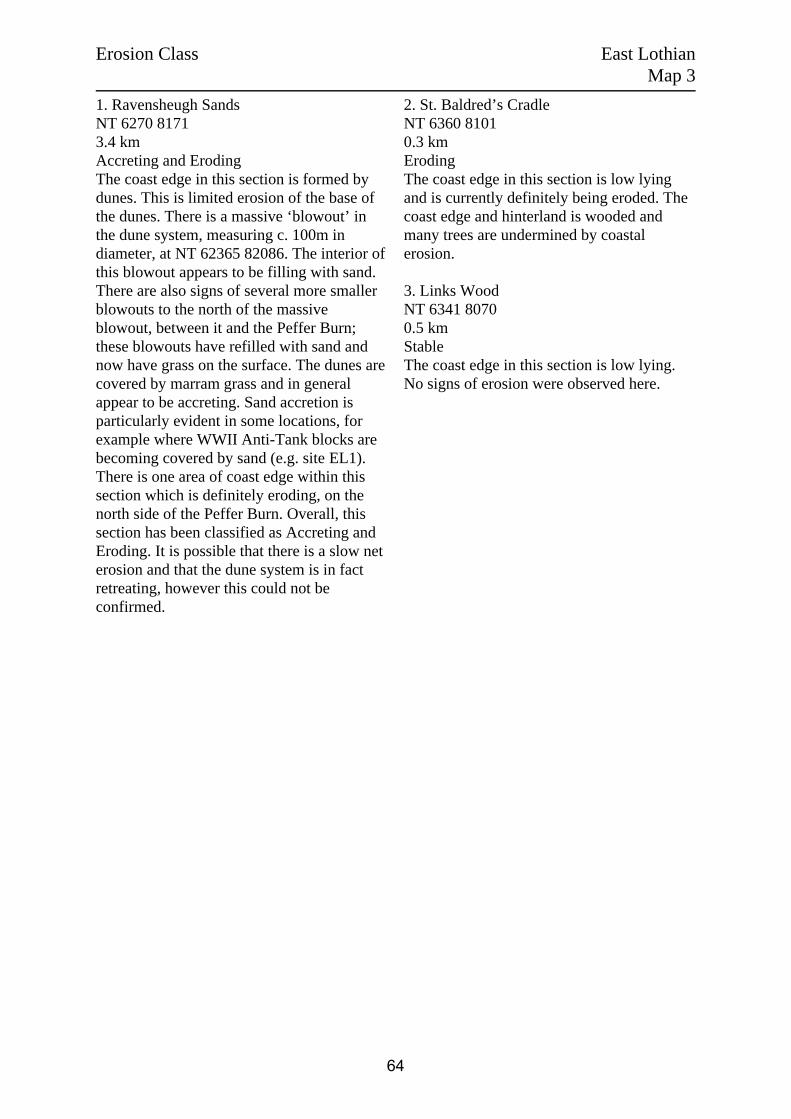
1. Ravensheugh SandsNT 6270 81713.4 kmAccreting and ErodingThe coast edge in this section is formed bydunes. This is limited erosion of the base ofthe dunes. There is a massive ‘blowout’ inthe dune system, measuring c. 100m indiameter, at NT 62365 82086. The interior ofthis blowout appears to be filling with sand.There are also signs of several more smallerblowouts to the north of the massiveblowout, between it and the Peffer Burn;these blowouts have refilled with sand andnow have grass on the surface. The dunes arecovered by marram grass and in generalappear to be accreting. Sand accretion is particularly evident in some locations, forexample where WWII Anti-Tank blocks arebecoming covered by sand (e.g. site EL1).There is one area of coast edge within thissection which is definitely eroding, on thenorth side of the Peffer Burn. Overall, thissection has been classified as Accreting andEroding. It is possible that there is a slow neterosion and that the dune system is in factretreating, however this could not beconfirmed.
2. St. Baldred’s CradleNT 6360 81010.3 kmErodingThe coast edge in this section is low lyingand is currently definitely being eroded. Thecoast edge and hinterland is wooded andmany trees are undermined by coastalerosion.
3. Links WoodNT 6341 80700.5 kmStableThe coast edge in this section is low lying.No signs of erosion were observed here.
Erosion Class East LothianMap 3
64

Scale: 1:25,000Survey Date: Feb 2006
Crow
n cop
yrigh
t. All r
ights r
eserve
d. Hi
storic
Scotl
and L
icenc
e No.
1000
1750
9 [20
06]
c
Map 3Erosion Class
1
3
2
Definitely Eroding
Accreting or Stable
Definitely Accreting
Accreting and Eroding
Eroding or Stable
Stable
Land below 10mNo access
Erosi
on Cl
ass
East Lothian
1 23
4
5 6 78 9 10 11
12131415
65

66

Map 4: Links Wood to Belhaven Bay
This map section extends around the Tyne Estuary and runs on into Belhaven Bay. The coast
edge here is low lying and composed for the most part of soft sandy sediments. Much of the
coast edge within the Tyne Estuary is protected by a substantial embankment (EL16) or by
sea walls. Salt marsh fills the area between Sandy Hirst and Fir Links Wood and this appears
to be gradually accreting. There are also areas of salt marsh on the coast edge to the north of
Hedderwick Hill Plantation. The land to the immediate north east of Hedderwick Hill
Plantation (marked as ‘John Muir Country park’ on the OS 1:25, 000) is low lying and
situated behind a dune system. It is likely that this area was once in the intertidal zone but
that has gradually become dry land. Within this section, the coastline has been classified as
mainly stable or accreting, but there are also pockets of localised severe erosion present.
Nineteen sites are recorded within this section, of six are newly identified by this survey.
Several of the new sites are probably associated with WWII defences (EL18, EL21). A
substantial wall, identified within the intertidal zone (EL36) may represent a fish trap, or
possibly a failed embankment. Past records indicate the existence of a major prehistoric site
in the area to the west of Hedderwick Burn (EL106). While no remains are currently visible
here, comparison with the 1996 GUARD survey indicates that the coast edge is eroding
particularly rapidly in this area.
67

EL 16 (NT67NW79)NT 6149 7859Buist's EmbankmentEmbankment and dyke18th-21st CGoodMonitor
EL 17 (NT67NW70)NT 62770 78439HedderwickWWII defences: anti-tankblocks18th-21st CGoodSurvey
EL 18NT 63017 78496Hedderwick SandsStructural remains:indeterminateIndeterminateFair/poorMonitor
EL 19 (NT67NW74)NT 640 795Hedderwick SandsWWII defences: anti-glidertraps18th-21st CFairSurvey
EL 20NT 64027 78824Hedderwick BurnFootbridge18th-21st CFairNil
EL 21NT 64156 80024Tyne SandsWWII Structure: indeterminate18th-21st CPoorSurvey
EL 35NT 63524 79967Sandy HirstStructural remains, wallingIndeterminatePoorNil
EL 36NT 634 793Tyne EstuaryFish trapIndeterminateFairSurvey
EL 103NT68SW8002Number cancelled in NMRS
EL 104 (NT68SW8011/8030)NT 63 80Tyne SandsShipwrecks18th -21st C?Survey
EL 105 (NT67NW8001)NT 63 70Tyninghame SandsShipwreck18th -21st C?Survey
EL 106 (NT67NW10)NT 638 788HedderwickCist and artefacts1st mill BC-1st mill ADPoorMonitor
EL 107 (NT67NW8002 etc)NT 64 79Tyningham SandsShipwrecks18th -21st C?Survey
EL 108 (NT67NW11)NT 64 79The Targets, DunbarBurialIndeterminate?Monitor
EL 109 (NT67NW75)NT 642 794Hedderwick Hill PlantationWWII defences: anti-tankblocks & structures18th-21st C?Monitor
EL 110 (NT67NW143)NT 643 799John Muir Country ParkHuman remainsIndeterminate?Monitor
EL 111 (NT68SW8007/8033)NT 64 80River TyneShipwrecks18th -21st C?Survey
EL 112 (NT67NE8048)NT 65 79Belhaven BayShipwreck18th -21st C?Survey
Built Heritage & East LothianArchaeology Map 4
68

Scale: 1:25,000Survey Date: Feb 2006
Crow
n cop
yrigh
t. All r
ights r
eserve
d. Hi
storic
Scotl
and L
icenc
e No.
1000
1750
9 [20
06]
c
Map 4Built Heritage &Archaeology
Protected Ancient Monument orarea of Designated Wreck
Monument formally proposed byHistoric Scotland for scheduling orwreck for designation
Listed Historic Building
Undesignated wreck
Known ancient monument
Site found by this survey
Site complex
Built
Herita
ge &
Arch
aeolog
y
Map 3
Map 5
EL111EL21
EL103
EL106
EL104
EL102
EL35
EL36
EL20
EL107EL108
EL112
EL17 EL18
EL109
EL16EL19
EL110
EL105
East Lothian
1 23
4
5 6 78 9 10 11
12131415
69

1. Tyne EstuaryNT 6263 78729.1 kmMostly SandCoast edge mostly <5mBlown SandThe foreshore in this area comprises sand,together with some sediment possiblyderived from the river Tyne. There is saltmarsh on the west side, by Mosshouse Pointand on the southern side of Sandy Hirst. Thecoast edge is defended by Buist’sEmbankment for much of the section. Thehinterland is mostly blown sand, occupied bya mix of woodland and farmed land.
Hinterland Geology & East LothianCoastal Geomorphology Map 4
70

Scale: 1:25,000Survey Date: Feb 2006
Crow
n cop
yrigh
t. All r
ights r
eserve
d. Hi
storic
Scotl
and L
icenc
e No.
1000
1750
9 [20
06]
c
Map 4Coastal GeomorphologyHinterland Geology &
Drift
Raised beach etc.
Glacial sand/gravel
Alluvium
Blown sand
Drift on visible rock
Hinte
rland
Rock platform
Mainly sand
Mainly alluvial/marine mud
Marsh
Fores
hore Low edge <5m
Cliff >5m
Man made barrier
Shingle/storm bank
Human disturbance
Modif
iers
1
East Lothian
1 23
4
5 6 78 9 10 11
12131415
71

1. Sandy Hirst NT 6350 80031.5 kmAccreting or StableThe coast edge within this section, the northside of the Sandy Hirst promontory of land islow lying. The upper foreshore isshingle/cobble and comprises a minor stormbeach. There does not appear to be anyencroachment of this material onto thehinterland and no signs of erosion wereobserved at the coast edge.
2. Little Binning WoodNT 6325 80150.4 kmDefinitely AccretingThis area of coast is formed by salt marsh,which is accreting. This coast edge hasadvanced past the line recorded on the OS1:25 000 map to fill much of the area to thesouth of Sandy Hirst. Several uprightwooden posts are visible, possibly WWIIGlider Traps, which have become engulfedby the salt marsh (see Site EL 19). It ispossible that the accumulation of sediment inthis area has been affected by the presence ofthe remains of a large fish trap or barrier nearby in the inter - tidal zone (see SiteEL36)
3. Mosshouse PointNT 6268 78652.8 kmStableThe coast edge here is low lying but stable.Much of the edge on the south side of thesection is formed by Buist’s Embankment, aman-made barrier (see site EL16).
4. Hedderwick HillNT 6364 78720.9 kmDefinitely ErodingThe coast edge rises to just over 5m high inthe section and is actively eroding. Freshexposures of material are visible throughout
this section. The remains of a tree, recentlyfallen over the edge, was observed in theintertidal zone at NT 63799 78790 (see pic17).
5. Hedderwick SandsNT 6414 79330.6 kmStableThe coast edge here is low lying. Woodlandlies in the hinterland. No erosion wasobserved during the survey.
6. Hedderwick Hill PlantationNT 6450 79500.3 kmDefinitely AccretingThe coast edge in this section comprises saltmarsh, which appears to be accreting.
7. Tyne SandsNT 6442 79820.6 kmStableThe coast edge in this section is grassed overand appears stable.
8. John Muir Country ParkNT 6415 80050.3 kmDefinitely ErodingThis section comprises the north west tip of apiece of land which juts out into the mouth ofthe Tyne Estuary. The coast edge here issubject to active erosion.
9. John Muir Country ParkNT 6494 79521.7 kmAccreting or StableThe coast edge in this section is generallystable. The hinterland comprises a dunesystem which is covered by marram grass.The grass appears to be thriving and istrapping blown sand.
Erosion Class East LothianMap 4
72

Scale: 1:25,000Survey Date: Feb 2006
Crow
n cop
yrigh
t. All r
ights r
eserve
d. Hi
storic
Scotl
and L
icenc
e No.
1000
1750
9 [20
06]
c
Map 4Erosion Class
1
3
5
7
4
6
8
9
Definitely Eroding
Accreting or Stable
Definitely Accreting
Accreting and Eroding
Eroding or Stable
Stable
Land below 10mNo access
Erosi
on Cl
ass
East Lothian
2
1 23
4
5 6 78 9 10 11
12131415
73

74

Map 5: Belhaven Bay to Dunbar
This map section includes Belhaven Bay and the town of Dunbar, which lies to its eastern
side. Much of this area has been developed and the coast edge is protected by sea walls and
defences from Long Craigs to Dunbar Golf Course at Deer Park. The coastline here is
classified as mainly stable, but there are localised areas of severe erosion along the edges of
Winterfield Golf Club, on the east side of Belhaven Bay. In these areas, sea defences, some
made from ex-situ WWII anti-tank blocks (EL23), have been erected in an effort to lessen the
impact of the waves. Thirty-four sites are recorded here; seven of which are new entries
identified by this survey. The new sites include wartime remains (EL26), a sea wall (EL28)
and a mound seen on AP's (EL167) but no longer in evidence on the ground. Within Dunbar,
the historic remains include Dunbar Castle (EL123), Lamer Island Battery (EL127) and the
harbours (EL124, EL129). Major discoveries have been made in recent years as a result of
pre-development archaeology: foremost among these is the site at Castle Park (EL164),
where excavation revealed remains ranging from an Iron Age fort to an Anglian timber hall,
with burials and medieval defences.
75

EL 22NT 6618 7888Belhaven BayFootbridge18th-21st CFairMonitor
EL 23NT 66296 78904Winterfield Golf CourseCoastal defences re-using WWII anti-tankblocks18th-21st CFairNil
EL 24 (see NT67NE161)NT 66230 79191Winterfield Golf Course? WWII structure18th-21st CPoorNil
EL 25NT 66225 79194Winterfield Golf CourseStructural remains: indeterminateIndeterminatePoorMonitor
EL 26 (NT67NE162)NT 66305 79256Winterfield Golf CourseWWII Structure: indeterminate18th-21st CPoorSurvey
EL 27 (NT67NE505/506)NT 66350 79250Winterfield Golf CourseCoastal defences re-using WWII anti-tankblocks18th-21st CFairNil
EL 28NT 66613 79188Winterfield MainsCoastal defences: sea wall18th-21st CPoorNil
EL 29NT 67104 79333WinterfieldMoundIndeterminateGoodMonitor
EL 113 (NT67NE159)NT 657 785Belhaven BaySea defence18th -21st CFairNil
EL 114 (NT67NE16)NT 6776 7796ListedLochendHouses, gate piers, cottages, garden, steading18th- 21st C?Monitor
EL 115 (NT67NE8037)NT 66 79Belhaven BayShipwreck18th -21st C?Survey
EL 116 (NT67NE1)NT 6631 7899Belhaven BayLong cist burials1st mill BC- 1st mill AD?Monitor
Built Heritage & East LothianArchaeology Map 5
76

EL 117 (NT67NE94)NT 668 791Winterfield Golf CourseLong cist burials1st mill BC- 1st mill AD?Monitor
EL 118 (NT67NE163)NT 669 793Winterfield Golf CourseWWII trenches & structure18th-21st C?Monitor
EL 119 (NT67NE242)NT 6759 7923Dunbar Swimming PoolSwimming pool18th -21st CGoodNil
EL 120 (NT67NE272)NT 677 792DunbarFindspot: gold pinIndeterminate?Monitor
EL 121 (NT67NE147)NT 6799 7932Victoria HarbourHarbour18th -21st CGoodNil
EL 122 (NT67NE503)NT 679 793Dunbar HarbourVaults, possible ice house18th- 21st CGoodMonitor
EL 123 (NT67NE8)NT 6782 7930Scheduled (766)Dunbar CastleCastleVariousPoorMonitor
EL 124 (NT67NE164)NT 678 793Dunbar HarbourWall18th- 21st CFairNil
EL 125 (NT67NE504)NT 6791 7926Victoria Harbour, DunbarWatching briefN/A?Nil
EL 126 (NT67NE404)NT 6825 7866East Links Road, Dunbar3, Clyde Villas18th- 21st CGoodNil
EL 127 (NT67NE53)NT 6811 7934Listed BLamer IslandBattery18th- 21st CFairMonitor
EL 128 (NT67NE8047)NT 682 794Siker Rocks, DunbarShipwreck18th -21st C?Survey
Built Heritage & East LothianArchaeology Map 5
77
EL 129 (NT67NE18)NT 6814 7922Listed BDunbar, Old HarbourHarbour14th- 18th CGoodMonitor
EL 130 (NT67NE177)NT 6810 7918Dunbar, Old HarbourSite of boat building yard18th- 21st CFairNil
EL 131 (NT67NE287)NT 6811 7913Dunbar, Old HarbourBarometer monument18th- 21st CFair/PoorNil
EL 132 (NT67NE500)NT 683 788 DunbarWallIndeterminate?N/AEL 133 (NT67NE275)NT 6874 7853DunbarEast Promenade18th- 21st CGoodNil
EL 134 (NT67NE2)NT 6873 7850Kirkhill BraesLong cist cemetery1st mill BC- 1st mill AD?Monitor
EL 135 (NT67NE186)NT 6882 7842Dunbar Golf CourseTrial Excavation1st mill BC- 1st mill ADGoodMonitor
EL 164 (NT67NE141.00 etc.)NT 6779 7922Scheduled (5960)Castle Park, DunbarTimber hall, burials etc.VariousFairMonitor
EL 166NT 6585 7850Winterfield MainsStructureIndeterminate?Nil
EL 167NT 6645 7927Winterfield Golf CourseMoundIndeterminate?Monitor
Built Heritage & East LothianArchaeology Map 5
78

Scale: 1:25,000Survey Date: Feb 2006
Crow
n cop
yrigh
t. All r
ights r
eserve
d. Hi
storic
Scotl
and L
icenc
e No.
1000
1750
9 [20
06]
c
Map 5Built Heritage &Archaeology
Protected Ancient Monument orarea of Designated Wreck
Monument formally proposed byHistoric Scotland for scheduling orwreck for designation
Listed Historic Building
Undesignated wreck
Known ancient monument
Site found by this survey
Site complex
Built
Herita
ge &
Arch
aeolog
y
Map 4
Map 6
EL128
EL164
EL118
EL125
EL113
EL28EL117
EL116EL167
EL133EL115
EL129
EL22
EL29
EL135
EL114EL166
EL130, EL131
EL120
EL126
EL23
EL24, EL25 EL132
EL121EL122EL123EL124
EL127
EL27
EL119
EL134
EL26
East Lothian
1 23
4
5 6 78 9 10 11
12131415
79

1. Belhaven BayNT 6550 78601.8 kmMostly SandCoast edge <5mDriftThe foreshore in Belhaven Bay is sandy. Thecoast edge is low lying; it is protected to thesouth by a wall. The hinterland is salt marshin the south west corner, elsewhere it isoccupied by development associated with acaravan park.
2. DunbarNT 6700 79404.4 kmRock PlatformCoast edge mostly >5mDriftThe foreshore around Dunbar is rockplatform. The edge is for the most partprotected by armouring. Erosion on the eastside of Belhaven Bay has exposed depositswhich may represent raised beach. Thehinterland is occupied by developmentassociated with the town of Dunbar, and agolf course. There are signs of landscapingon the golf course, particularly associatedwith the construction of features such as tees,greens and bunkers - dumped soil wasobserved in section on the east side ofBelhaven Bay.
Hinterland Geology & East LothianCoastal Geomorphology Map 5
80

Scale: 1:25,000Survey Date: Feb 2006
Crow
n cop
yrigh
t. All r
ights r
eserve
d. Hi
storic
Scotl
and L
icenc
e No.
1000
1750
9 [20
06]
c
Map 5Coastal GeomorphologyHinterland Geology &
Drift
Raised beach etc.
Glacial sand/gravel
Alluvium
Blown sand
Drift on visible rock
Hinte
rland
Rock platform
Mainly sand
Mainly alluvial/marine mud
Marsh
Fores
hore Low edge <5m
Cliff >5m
Man made barrier
Shingle/storm bank
Human disturbance
Modif
iers
1
2
East Lothian
1 23
4
5 6 78 9 10 11
12131415
81

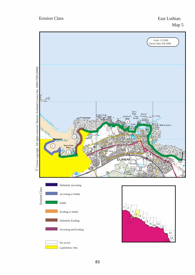
1. Belhaven Bay (west)NT 6531 78751.1 kmAccreting or StableThis section comprises the west side ofBelhaven bay. The coast edge here is lowlying and formed by salt marsh. No erosionwas observed. It appears, from a comparisonof the coast edge as presented by the OS 1:25000 and the coast edge visible at the time ofthe survey, that this section may be accreting.
2. Belhaven Bay (south)NT 6600 78540.4 kmStableThe coast edge on the south part of BelhavenBay is formed by a substantial wall. Noerosion was observed here.
3. Belhaven Bay (east)NT 6630 78951.0 kmDefinitely ErodingThis section comprises the east side ofBelhaven Bay. The edge rises here to avertical face. There has been some attempt toarmour the edge using WWII Anti-Tankblocks and gabion walling however it isapparent that this armouring is degraded andnow fragile (see Site EL23). In other places,where there is no armouring, fresh erosionfaces are visible. Old ?beach deposits areexposed here.
4. DunbarNT 6730 79303.7 kmStableThe coast edge here comprises high grassycliffs. The tops of the cliffs is generallydefended by concrete roads and promenadesby the town of Dunbar and is stable. The bayat St Margaret’s is stable and armoured byreused WWII Anti-Tank Blocks (see SiteEL27)
Erosion Class East LothianMap 5
82
Scale: 1:25,000Survey Date: Feb 2006
Crow
n cop
yrigh
t. All r
ights r
eserve
d. Hi
storic
Scotl
and L
icenc
e No.
1000
1750
9 [20
06]
c
Map 5Erosion Class
1
3
2
4
Definitely Eroding
Accreting or Stable
Definitely Accreting
Accreting and Eroding
Eroding or Stable
Stable
Land below 10mNo access
Erosi
on Cl
ass
East Lothian
1 23
4
5 6 78 9 10 11
12131415
83

84

Map 6: Dunbar to Barns Ness
This map section extends from the east side of Dunbar to the Barns Ness Promontory. The
majority of this coastline lies within Dunbar Golf Course and is well maintained, with
armouring and sea walls in evidence throughout. The coast edge here is low-lying but rocky
with reefs in the intertidal zone. There is a sandy beach at Cat Craig, to the west side of Barns
Ness. The vegetation levels within the area covered by the golf course are kept low but on
Barns Ness there are higher maritime grasses which are likely to impede site visibility. A
total of thirteen sites were noted here, of which two represent new entries identified by this
survey. One of the new sites is a probable landing place/slipway (EL32) at Mill Stone Neuk.
The second is a harbour and tie-up post (EL31) which stands in front of a row of former
cottages, known as 'The Vaults' (EL30). Previous records detail cist burials (EL141); these
are no longer in evidence. A 19th C lime kiln at Cat Craig is almost complete but in a poor
structural condition: it bears a dangerous building notice and is no longer accessible.
85

EL 30 (NT77NW36)NT 7019 7820Listed BDunbar Golf Course, TheVaultsStructure18th-21st CGoodMonitor
EL 31NT 70208 78219Dunbar Golf LinksHarbour with tie-up post18th-21st CGoodMonitor
EL 32NT 70558 78167Dunbar Golf LinksSlipwayIndeterminateFairNil
EL 33 (NT77NW33)NT 71499 77260Scheduled (5675) /Listed B CatcraigLime kilns, quarry18th-21st CFairMonitor
EL 34 (NT77NW62)NT 7077 7750Mid LinksStructural Remains18th-21st CFairMonitor
EL 136 (NT67NE17.09)NT 6964 7810Broxmouth ParkFoot bridge18th- 21st CGoodNil
EL 137 (NT77NW28)NT 700 782The VaultsCists1st mill BC- 1st mill AD?Monitor
EL 138 (NT77NW8012)NT 70 78Vault PointShipwreck18th -21st C?Survey
EL 139 (NT77NW8003)NT 706 781Mill Stone NeukShipwreck18th -21st C?Survey
EL 140 (NT77NW42)NT 707 780White SandsMill stone quarry18th- 21st CGoodNil
EL 141 (NT77NW4)NT 7066 7766Dunbar Golf CourseCists3rd- 1st mill BC?Monitor
EL 142 (NT77NW62)NT 7077 7750Mid LinksStructure: former house18th- 21st CFairNil
EL 143 (NT77NW90)NT 7095 7729White SandsEvaluation & watching briefN/A?Monitor
EL 144 (NT77NW8018)NT 72 77 Barns NessShipwreck18th -21st C?Survey
Built Heritage & East LothianArchaeology Map 6
86

Scale: 1:25,000Survey Date: Feb 2006
Crow
n cop
yrigh
t. All r
ights r
eserve
d. Hi
storic
Scotl
and L
icenc
e No.
1000
1750
9 [20
06]
c
Map 6Built Heritage &Archaeology
Protected Ancient Monument orarea of Designated Wreck
Monument formally proposed byHistoric Scotland for scheduling orwreck for designation
Listed Historic Building
Undesignated wreck
Known ancient monument
Site found by this survey
Site complex
Built
Herita
ge &
Arch
aeolog
y
Map 5
Map 7EL33
EL136
EL32
EL144
EL139
EL34, EL142
EL140
EL137
EL138
EL143
EL141
EL30, EL31
East Lothian
1 23
4
5 6 78 9 10 11
12131415
87

1. BroxburnNT 7000 78302.4 kmRock PlatformCoast edge <5mDriftThe foreshore in this section is rockplatform, which has much cobble cover onthe upper foreshore, against the coast edge. Astorm beach appears to be developing at NT70704 77945 - a 40m long cobble bank up to2m high. A golf course occupies thehinterland, and there appears to have beensome disturbance of the hinterland and of thecoast edge associated with this. The edge hasbeen armoured by a combination of dumpedsoil and rubble, railway sleepers driven invertically to the coast edge, and some gabionwalling, particularly on the banks of a smallstream.
2. CatcraigNT 7135 77231.8 kmMostly SandCoast edge <5mBlown SandThe foreshore in this area is mostly sand,with a stretch of rock platform in the centre.The coast edge is low, with a thin strip ofdunes behind. The dunes are covered withmarram grass.
Hinterland Geology & East LothianCoastal Geomorphology Map 6
88

Scale: 1:25,000Survey Date: Feb 2006
Crow
n cop
yrigh
t. All r
ights r
eserve
d. Hi
storic
Scotl
and L
icenc
e No.
1000
1750
9 [20
06]
c
Map 6Coastal GeomorphologyHinterland Geology &
Drift
Raised beach etc.
Glacial sand/gravel
Alluvium
Blown sand
Drift on visible rock
Hinte
rland
Rock platform
Mainly sand
Mainly alluvial/marine mud
Marsh
Fores
hore Low edge <5m
Cliff >5m
Man made barrier
Shingle/storm bank
Human disturbance
Modif
iers
1
2
East Lothian
1 23
4
5 6 78 9 10 11
12131415
89

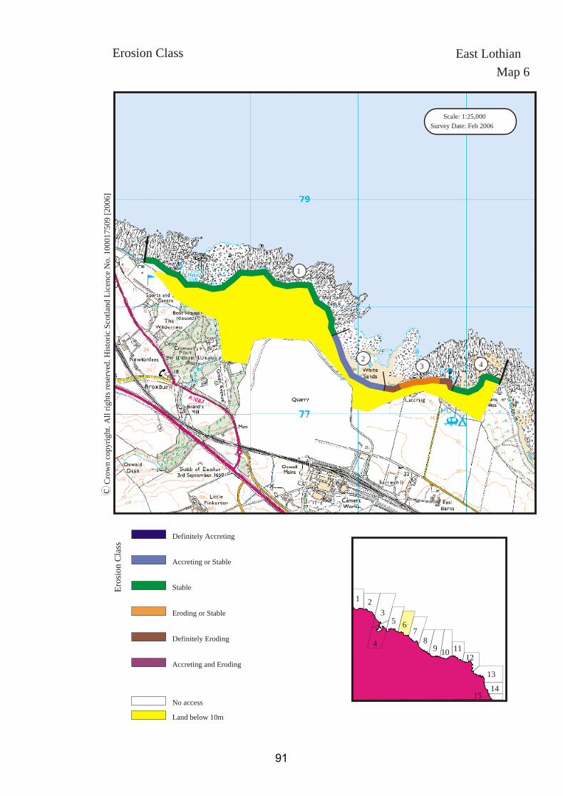
1. Lawrie’s DenNT 7000 78302.1 kmStableThe coast edge in this section is low lyingand the hinterland is occupied by a golfcourse. The coast edge is entirely armouredin front of this golf course by a combinationof gabion walling (at the Brox Burn), oldrailway sleepers set vertically into theground, and dumping of soil and rubble,presumably deriving from work on the golfcourse.
2. White SandsNT 7100 77320.8 kmAccreting or StableLow lying coast edge. Marram grass at theedge, which appears to be trapping sand. Nosigns of erosion.
3. CatcraigNT 7160 77300.7 kmEroding or StableThe coast edge within this section variesfrom low lying to low rocky cliffs. there aremany small erosion faces visible at the edgeas well as the two larger stretches marked onthe map. The hinterland has been disturbedby previous quarrying and dumping ofquarry waste.
4. Barns NessNT 7215 77330.6 kmStableThe coast edge in this section is low lyingbut appears to be stable. No signs of erosionnoted during survey.
Erosion Class East LothianMap 6
90
Scale: 1:25,000Survey Date: Feb 2006
Crow
n cop
yrigh
t. All r
ights r
eserve
d. Hi
storic
Scotl
and L
icenc
e No.
1000
1750
9 [20
06]
c
Map 6Erosion Class
1
32 4
Definitely Eroding
Accreting or Stable
Definitely Accreting
Accreting and Eroding
Eroding or Stable
Stable
Land below 10mNo access
Erosi
on Cl
ass
East Lothian
1 23
4
5 6 78 9 10 11
12131415
91