Managing Invasive Non-Native Species in Scotland’s Water ... · “Managing Invasive-Non-Native...
31
Managing Invasive Non-Native Species in Scotland’s Water Environment: A summary of local actions
Transcript of Managing Invasive Non-Native Species in Scotland’s Water ... · “Managing Invasive-Non-Native...
Managing Invasive Non-Native Species in Scotland’s Water Environment: A summary of local actions

2
This short summary document is intended to support the supplementary plan “Managing Invasive-Non-Native Species in Scotland‟s Water Environment” and outlines the local actions which are currently being taken forward in the Scotland and Solway Tweed River Basin Districts (RBDs). It also highlights the types of data collected by those public bodies and partner organisations which have responsibilities for the management of INNS and how these are used in classifying waters in Scotland. The summary is intended to present a “live” account of local action across both RBDs, with the intention that it will be updated annually by SEPA. In future, it will also include maps and tables1 showing those water bodies which are currently failing to achieve “good ecological status” and those at risk of failing to meet the “no deterioration” objective. Table 1 identifies the actions in Scotland currently taking place with regards to assessment and monitoring of individual species and describes how these are used in classification of WFD water bodies. Table 2 describes a list of local preventative, control and eradication actions at the RBMP AAG level, focussing on individual water bodies.
1 Classification and risk assessment data for 2012 were not available for inclusion at the time
of publication but this document will be updated to include this information once the data are made available.
3
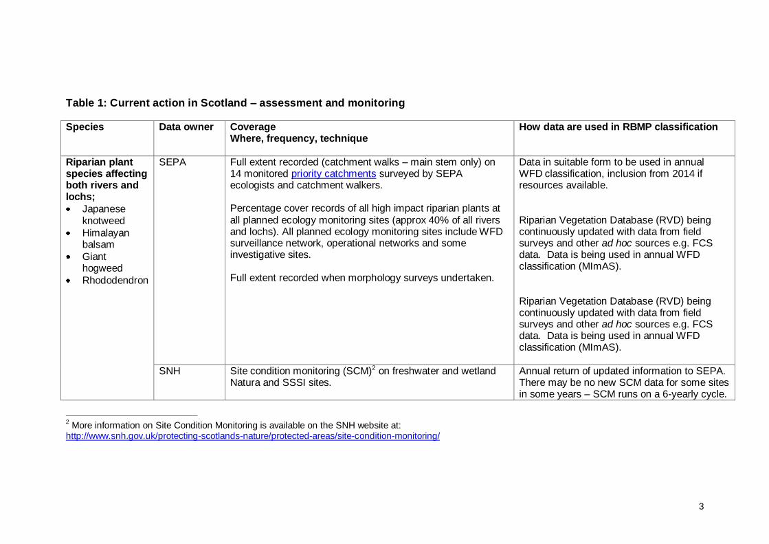
Table 1: Current action in Scotland – assessment and monitoring Species Data owner Coverage
Where, frequency, technique
How data are used in RBMP classification
Riparian plant species affecting both rivers and lochs;
Japanese knotweed
Himalayan balsam
Giant hogweed
Rhododendron
SEPA Full extent recorded (catchment walks – main stem only) on 14 monitored priority catchments surveyed by SEPA ecologists and catchment walkers. Percentage cover records of all high impact riparian plants at all planned ecology monitoring sites (approx 40% of all rivers and lochs). All planned ecology monitoring sites include WFD surveillance network, operational networks and some investigative sites. Full extent recorded when morphology surveys undertaken.
Data in suitable form to be used in annual WFD classification, inclusion from 2014 if resources available. Riparian Vegetation Database (RVD) being continuously updated with data from field surveys and other ad hoc sources e.g. FCS data. Data is being used in annual WFD classification (MImAS). Riparian Vegetation Database (RVD) being continuously updated with data from field surveys and other ad hoc sources e.g. FCS data. Data is being used in annual WFD classification (MImAS).
SNH Site condition monitoring (SCM)2 on freshwater and wetland Natura and SSSI sites.
Annual return of updated information to SEPA. There may be no new SCM data for some sites in some years – SCM runs on a 6-yearly cycle.
2 More information on Site Condition Monitoring is available on the SNH website at:
http://www.snh.gov.uk/protecting-scotlands-nature/protected-areas/site-condition-monitoring/
4
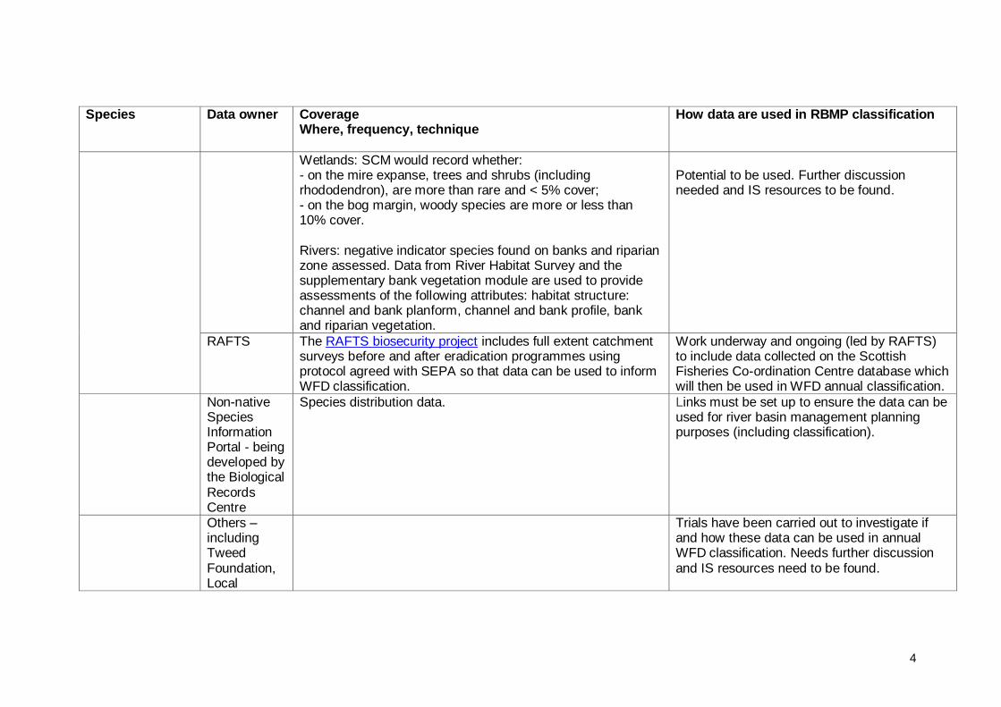
Species Data owner Coverage Where, frequency, technique
How data are used in RBMP classification
Wetlands: SCM would record whether: - on the mire expanse, trees and shrubs (including rhododendron), are more than rare and < 5% cover; - on the bog margin, woody species are more or less than 10% cover. Rivers: negative indicator species found on banks and riparian zone assessed. Data from River Habitat Survey and the supplementary bank vegetation module are used to provide assessments of the following attributes: habitat structure: channel and bank planform, channel and bank profile, bank and riparian vegetation.
Potential to be used. Further discussion needed and IS resources to be found.
RAFTS The RAFTS biosecurity project includes full extent catchment surveys before and after eradication programmes using protocol agreed with SEPA so that data can be used to inform WFD classification.
Work underway and ongoing (led by RAFTS) to include data collected on the Scottish Fisheries Co-ordination Centre database which will then be used in WFD annual classification.
Non-native Species Information Portal - being developed by the Biological Records Centre
Species distribution data. Links must be set up to ensure the data can be used for river basin management planning purposes (including classification).
Others – including Tweed Foundation, Local
Trials have been carried out to investigate if and how these data can be used in annual WFD classification. Needs further discussion and IS resources need to be found.
5
Species Data owner Coverage Where, frequency, technique
How data are used in RBMP classification
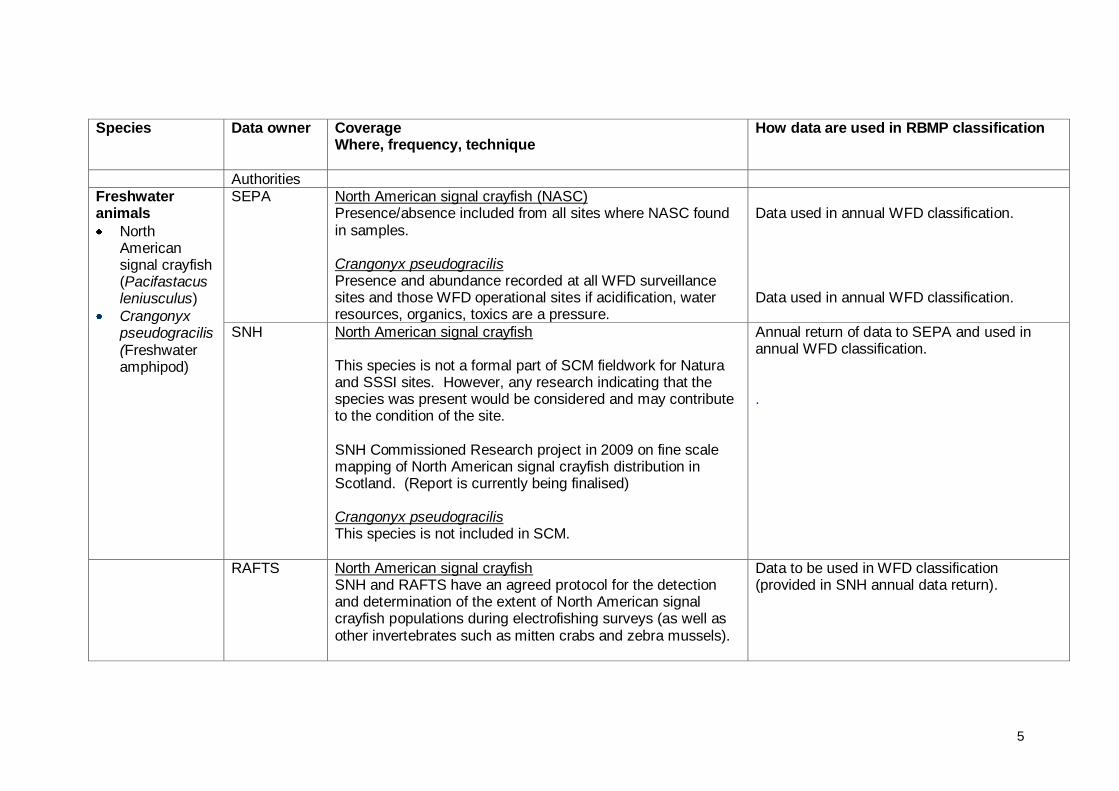
Authorities Freshwater animals
North American signal crayfish (Pacifastacus leniusculus)
Crangonyx pseudogracilis (Freshwater amphipod)
SEPA North American signal crayfish (NASC) Presence/absence included from all sites where NASC found in samples. Crangonyx pseudogracilis Presence and abundance recorded at all WFD surveillance sites and those WFD operational sites if acidification, water resources, organics, toxics are a pressure.
Data used in annual WFD classification. Data used in annual WFD classification.
SNH North American signal crayfish This species is not a formal part of SCM fieldwork for Natura and SSSI sites. However, any research indicating that the species was present would be considered and may contribute to the condition of the site. SNH Commissioned Research project in 2009 on fine scale mapping of North American signal crayfish distribution in Scotland. (Report is currently being finalised) Crangonyx pseudogracilis This species is not included in SCM.
Annual return of data to SEPA and used in annual WFD classification. .
RAFTS North American signal crayfish SNH and RAFTS have an agreed protocol for the detection and determination of the extent of North American signal crayfish populations during electrofishing surveys (as well as other invertebrates such as mitten crabs and zebra mussels).
Data to be used in WFD classification (provided in SNH annual data return).
6
Species Data owner Coverage Where, frequency, technique
How data are used in RBMP classification
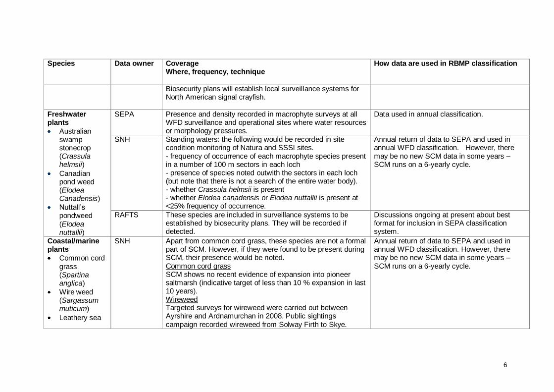
Biosecurity plans will establish local surveillance systems for North American signal crayfish.
Freshwater plants
Australian swamp stonecrop (Crassula helmsii)
Canadian pond weed (Elodea Canadensis)
Nuttall‟s pondweed (Elodea nuttallii)
SEPA Presence and density recorded in macrophyte surveys at all WFD surveillance and operational sites where water resources or morphology pressures.
Data used in annual classification.
SNH Standing waters: the following would be recorded in site condition monitoring of Natura and SSSI sites. - frequency of occurrence of each macrophyte species present in a number of 100 m sectors in each loch - presence of species noted outwith the sectors in each loch (but note that there is not a search of the entire water body). - whether Crassula helmsii is present - whether Elodea canadensis or Elodea nuttallii is present at <25% frequency of occurrence.
Annual return of data to SEPA and used in annual WFD classification. However, there may be no new SCM data in some years – SCM runs on a 6-yearly cycle.
RAFTS These species are included in surveillance systems to be established by biosecurity plans. They will be recorded if detected.
Discussions ongoing at present about best format for inclusion in SEPA classification system.
Coastal/marine plants
Common cord grass (Spartina anglica)
Wire weed (Sargassum muticum)
Leathery sea
SNH Apart from common cord grass, these species are not a formal part of SCM. However, if they were found to be present during SCM, their presence would be noted. Common cord grass SCM shows no recent evidence of expansion into pioneer saltmarsh (indicative target of less than 10 % expansion in last 10 years). Wireweed Targeted surveys for wireweed were carried out between Ayrshire and Ardnamurchan in 2008. Public sightings campaign recorded wireweed from Solway Firth to Skye.
Annual return of data to SEPA and used in annual WFD classification. However, there may be no new SCM data in some years – SCM runs on a 6-yearly cycle.
7
Species Data owner Coverage Where, frequency, technique
How data are used in RBMP classification
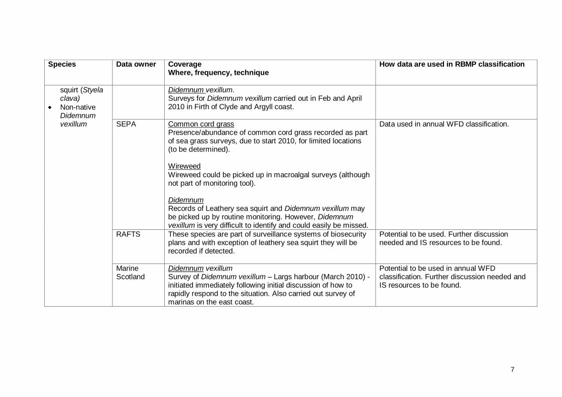
squirt (Styela clava)
Non-native Didemnum vexillum
Didemnum vexillum. Surveys for Didemnum vexillum carried out in Feb and April 2010 in Firth of Clyde and Argyll coast.
SEPA Common cord grass Presence/abundance of common cord grass recorded as part of sea grass surveys, due to start 2010, for limited locations (to be determined). Wireweed Wireweed could be picked up in macroalgal surveys (although not part of monitoring tool). Didemnum Records of Leathery sea squirt and Didemnum vexillum may be picked up by routine monitoring. However, Didemnum vexillum is very difficult to identify and could easily be missed.
Data used in annual WFD classification.
RAFTS These species are part of surveillance systems of biosecurity plans and with exception of leathery sea squirt they will be recorded if detected.
Potential to be used. Further discussion needed and IS resources to be found.
Marine Scotland
Didemnum vexillum Survey of Didemnum vexillum – Largs harbour (March 2010) - initiated immediately following initial discussion of how to rapidly respond to the situation. Also carried out survey of marinas on the east coast.
Potential to be used in annual WFD classification. Further discussion needed and IS resources to be found.
8
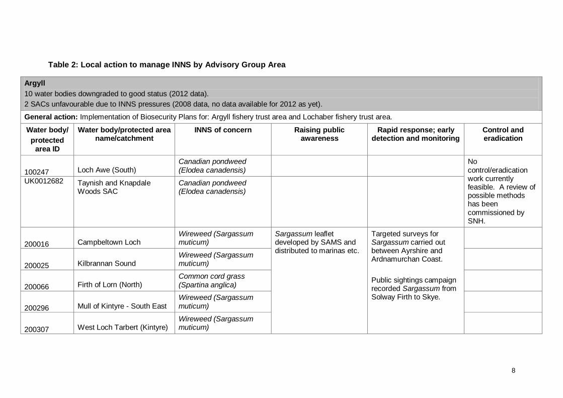
Table 2: Local action to manage INNS by Advisory Group Area
Argyll
10 water bodies downgraded to good status (2012 data).
2 SACs unfavourable due to INNS pressures (2008 data, no data available for 2012 as yet).
General action: Implementation of Biosecurity Plans for: Argyll fishery trust area and Lochaber fishery trust area.
Water body/
protected area ID
Water body/protected area name/catchment
INNS of concern Raising public awareness
Rapid response; early detection and monitoring
Control and eradication
100247 Loch Awe (South) Canadian pondweed (Elodea canadensis)
No control/eradication work currently feasible. A review of possible methods has been commissioned by SNH.
UK0012682 Taynish and Knapdale Woods SAC
Canadian pondweed (Elodea canadensis)
200016 Campbeltown Loch Wireweed (Sargassum muticum)
Sargassum leaflet developed by SAMS and distributed to marinas etc.
Targeted surveys for Sargassum carried out between Ayrshire and Ardnamurchan Coast.
Public sightings campaign recorded Sargassum from Solway Firth to Skye.
200025 Kilbrannan Sound Wireweed (Sargassum muticum)
200066 Firth of Lorn (North) Common cord grass (Spartina anglica)
200296 Mull of Kintyre - South East Wireweed (Sargassum muticum)
200307 West Loch Tarbert (Kintyre) Wireweed (Sargassum muticum)

9
200312 Machrihanish Wireweed (Sargassum muticum)
UK0030209 Loch Moidart and Loch Shiel Woods SAC
Rhododendron Control/eradication work is ongoing on part of the site, and work is underway to develop a plan for control/eradication on the remainder of the site.
Argyll coastal water bodies Didemnum vexillum Surveys for Didemnum vexillum carried out in Feb and April 2010. No Didemnum found.
Awe catchment, including focused project on Eredine area (south west), River Lochy, River Aline, River Leven, Polloch River, Strontian River,
Riparian INNS; Rhododendron, Japanese knotweed and Himalayan balsam
Argyll Fisheries Trust leading on control and eradication programmes with others (including Forestry Commission). Forestry Commission Scotland is leading a rhododendron control, demonstration project in Argyll & Bute, working with partners.
10
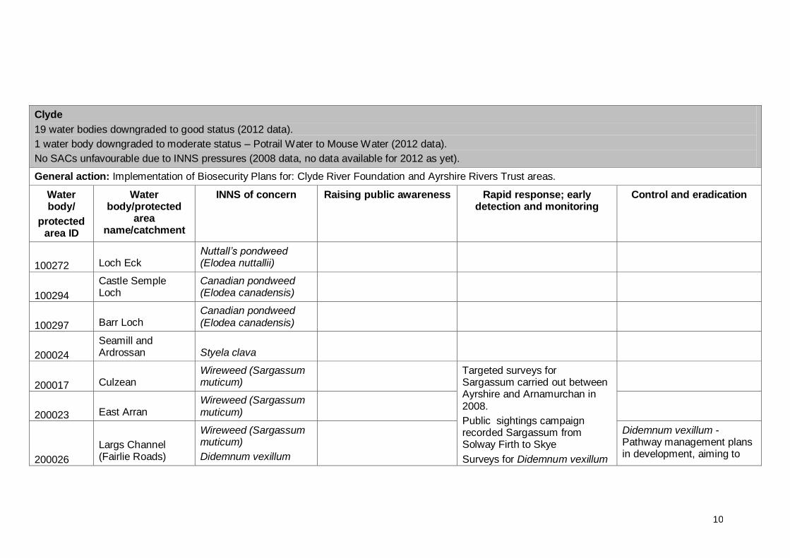
Clyde
19 water bodies downgraded to good status (2012 data).
1 water body downgraded to moderate status – Potrail Water to Mouse Water (2012 data).
No SACs unfavourable due to INNS pressures (2008 data, no data available for 2012 as yet).
General action: Implementation of Biosecurity Plans for: Clyde River Foundation and Ayrshire Rivers Trust areas.
Water body/
protected area ID
Water body/protected
area name/catchment
INNS of concern Raising public awareness Rapid response; early detection and monitoring
Control and eradication
100272 Loch Eck Nuttall’s pondweed (Elodea nuttallii)
100294
Castle Semple Loch
Canadian pondweed (Elodea canadensis)
100297 Barr Loch Canadian pondweed (Elodea canadensis)
200024
Seamill and Ardrossan Styela clava
200017 Culzean Wireweed (Sargassum muticum)
Targeted surveys for Sargassum carried out between Ayrshire and Arnamurchan in 2008.
Public sightings campaign recorded Sargassum from Solway Firth to Skye
Surveys for Didemnum vexillum
200023 East Arran Wireweed (Sargassum muticum)
200026
Largs Channel (Fairlie Roads)
Wireweed (Sargassum muticum)
Didemnum vexillum
Didemnum vexillum - Pathway management plans in development, aiming to
11
carried out in Feb and April 2010 in Firth of Clyde.
Survey of Didemnum vexillum in Yacht Haven (March 2010). Clean up operation in Largs to remove unwanted submerged items (March 2010)
Eradication programme considered.
reduce further spread.
200027 Sound of Bute Wireweed (Sargassum muticum)
200028
Firth of Clyde Inner - Cumbraes
Wireweed (Sargassum muticum)
200036
Firth of Clyde Inner - Dunoon and Wemyss Bay
Wireweed (Sargassum muticum)
Didemnum ssp Surveys for Didemnum vexillum carried out in Feb and April 2010 in Firth of Clyde.
Survey of Didemnum vexillum in Largs Harbour (March 2010).
Rivers Irvine, Ayr, Girvan, Stinchar, Doon and Garnock.
Riparian INNS Ayrshire Rivers Trust leading on projects.
Clyde River Foundation survey work to identify INNS.
12
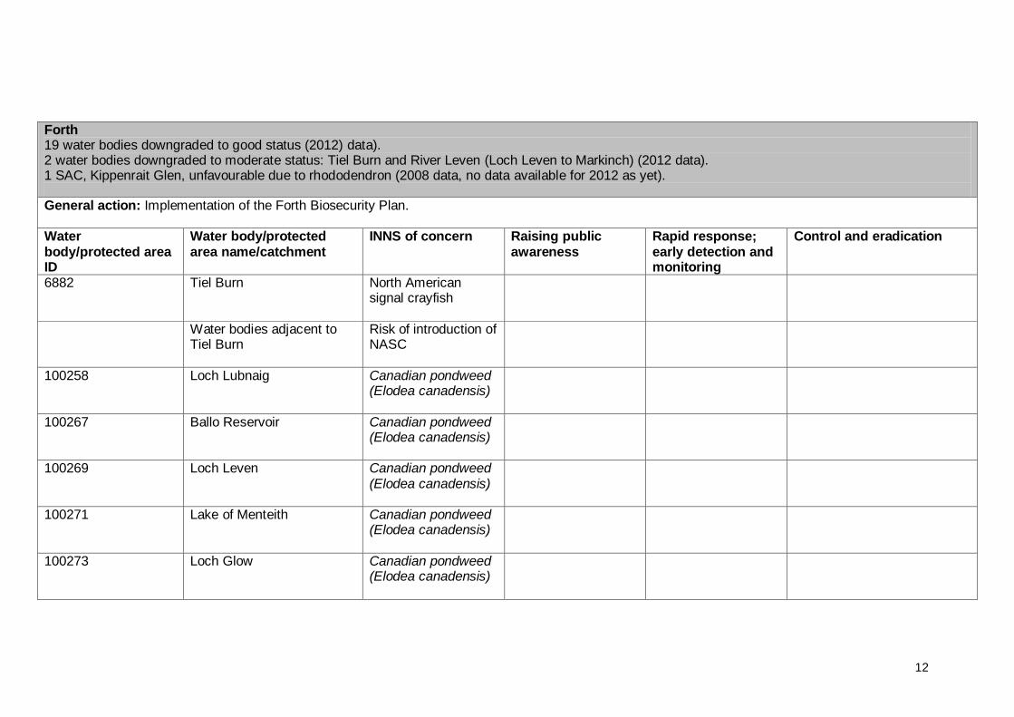
Forth 19 water bodies downgraded to good status (2012) data). 2 water bodies downgraded to moderate status: Tiel Burn and River Leven (Loch Leven to Markinch) (2012 data). 1 SAC, Kippenrait Glen, unfavourable due to rhododendron (2008 data, no data available for 2012 as yet).
General action: Implementation of the Forth Biosecurity Plan. Water body/protected area ID
Water body/protected area name/catchment
INNS of concern Raising public awareness
Rapid response; early detection and monitoring
Control and eradication
6882 Tiel Burn North American signal crayfish
Water bodies adjacent to Tiel Burn
Risk of introduction of NASC
100258 Loch Lubnaig Canadian pondweed (Elodea canadensis)
100267 Ballo Reservoir Canadian pondweed (Elodea canadensis)
100269 Loch Leven Canadian pondweed (Elodea canadensis)
100271 Lake of Menteith Canadian pondweed (Elodea canadensis)
100273 Loch Glow Canadian pondweed (Elodea canadensis)

13
100276 Gartmorn Dam Canadian pondweed (Elodea canadensis)
100278 Loch Fitty Canadian pondweed (Elodea canadensis)
100291 Threipmuir Reservoir Canadian pondweed (Elodea canadensis)
100302 Gladhouse Reservoir Canadian pondweed (Elodea canadensis)
UK0030177 Kippenrait Glen SAC Rhododendron A plan covering multiple land ownerships is required to address a number of exotic species, and rhododendron in particular. FCS is lead agency.
River Allan from Greenloaning to confluence with River Forth, Endrick Water and Blane Waters, River Forth, River Teith, River Devon
Riparian INNS Local authority and SNH control and eradication projects; details not yet confirmed.
14
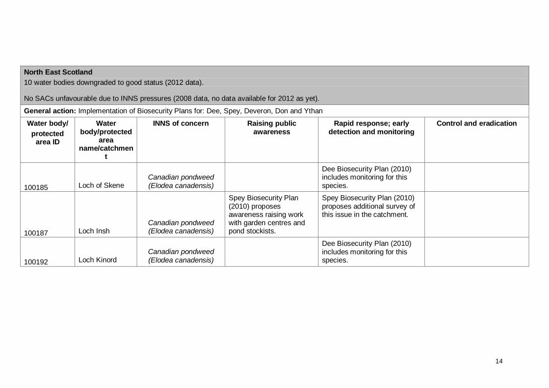
North East Scotland
10 water bodies downgraded to good status (2012 data).
No SACs unfavourable due to INNS pressures (2008 data, no data available for 2012 as yet).
General action: Implementation of Biosecurity Plans for: Dee, Spey, Deveron, Don and Ythan
Water body/
protected area ID
Water body/protected
area name/catchmen
t
INNS of concern Raising public awareness
Rapid response; early detection and monitoring
Control and eradication
100185 Loch of Skene Canadian pondweed (Elodea canadensis)
Dee Biosecurity Plan (2010) includes monitoring for this species.
100187 Loch Insh Canadian pondweed (Elodea canadensis)
Spey Biosecurity Plan (2010) proposes awareness raising work with garden centres and pond stockists.
Spey Biosecurity Plan (2010) proposes additional survey of this issue in the catchment.
100192 Loch Kinord Canadian pondweed (Elodea canadensis)
Dee Biosecurity Plan (2010) includes monitoring for this species.

15
Deveron District upper River Bervie Riparian INNS
Deveron Biosecurity Plan (2009) contains measures on awareness raising for riparian INNS.
Deveron Biosecurity Plan (2009) contains measures on rapid response for riparian INNS.
Deveron district led by Deveron, Bogie and Isla Trust with project to control Himalayan balsam, Japanese knotweed and Giant Hogweed Project also controls mink. Includes funding by Leader, Aberdeenshire and Moray
Councils and SNH.
Esk Rivers and Fisheries Trust.

16
North Highland
5 water bodies downgraded to good status (2012 data).
1 water body downgraded to moderate status: Geddes Burn (2012 data).
1 SAC, unfavourable due to pressures including INNS (2008 data, no data available for 2012 as yet).
General action: Implementation of Biosecurity Plans for: Cromarty Firth, Kyle of Sutherland, West Sutherland, Ness and Beauly
Water body/
protected area ID
Water body/protected
area name/catchment
INNS of concern Raising public awareness
Rapid response; early detection and monitoring
Control and eradication
20308 Geddes Burn North American signal crayfish
Fishery Board have a programme of baited traps primarily in the lower burn which are regularly checked. Trapping effort 2009 and 2010.
Water bodies adjacent to Geddes Burn
Risk of introduction of NASC
Fishery Board have a programme of baited traps in main stem of river Nairn which are regularly checked. Trapping effort 2009 and 2010.
100107 Loch Eye Canadian pondweed (Elodea canadensis)
100139 Loch Ussie Canadian pondweed (Elodea canadensis)
200442
Outer Cromarty Firth
Common cord grass (Spartina anglica)

17
200443
Inner Cromarty Firth
Common cord grass (Spartina anglica)
RSPB run an eradication programme centred on Nigg and Udale Bays National Nature Reserve but there is an issue with colonisation outwith their ownership, particularly in Dingwall Bay.
Urquhart Bay Wood SAC,
INNS include Japanese knotweed and Himalayan balsam
Expected to be in unfavourable/ favourable recovering by 2015 but only if management of INNS continues. Control of INNS has been ongoing for the last three years with SNH funding this work. Work and funding ended on 30 January 2011.
Rosskeen Burn, Ussie Burn, Balnagowan Burn, Sgitheach, Allt Graad, Alness, Peffery, Orrin catchment, Conon
Riparian INNS; Himalayan balsam, Japanese knotweed, possibly giant hogweed.
Control and eradication projects led by Cromarty Firth Fisheries Trust.
Fisheries Trust has biohazard reports that contain all species affected.
18
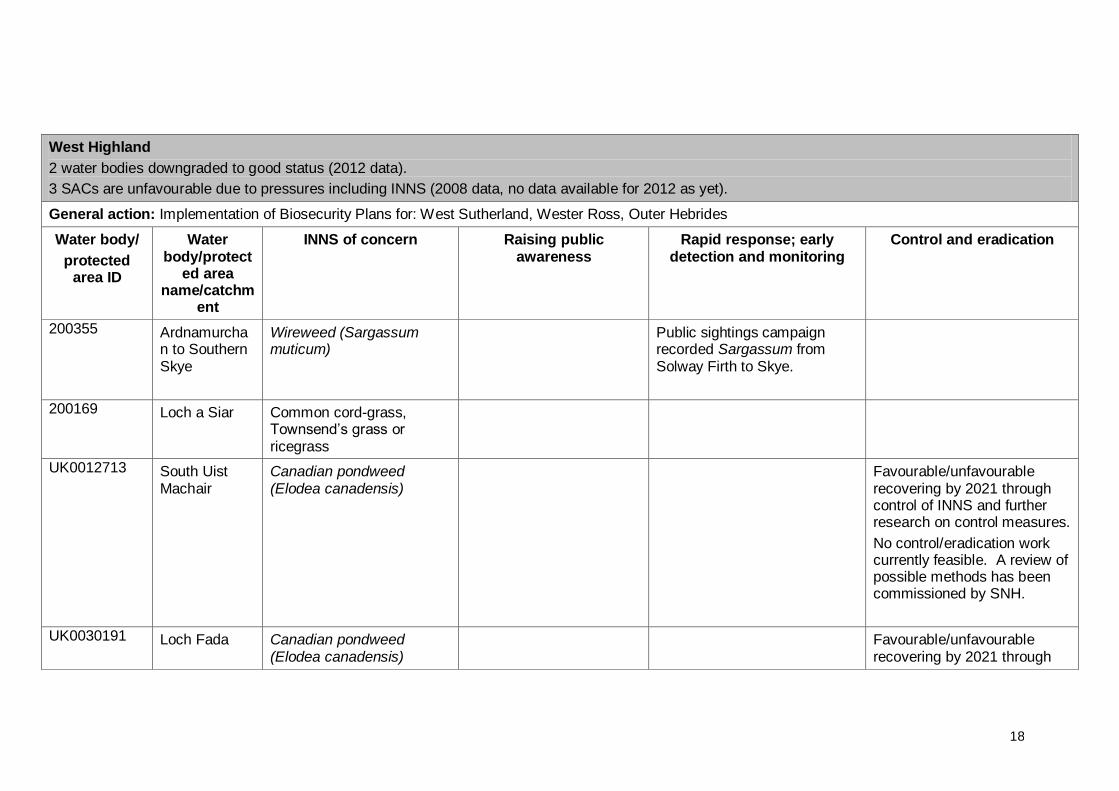
West Highland
2 water bodies downgraded to good status (2012 data).
3 SACs are unfavourable due to pressures including INNS (2008 data, no data available for 2012 as yet).
General action: Implementation of Biosecurity Plans for: West Sutherland, Wester Ross, Outer Hebrides
Water body/
protected area ID
Water body/protect
ed area name/catchm
ent
INNS of concern Raising public awareness
Rapid response; early detection and monitoring
Control and eradication
200355 Ardnamurchan to Southern Skye
Wireweed (Sargassum muticum)
Public sightings campaign recorded Sargassum from Solway Firth to Skye.
200169 Loch a Siar Common cord-grass, Townsend‟s grass or ricegrass
UK0012713 South Uist Machair
Canadian pondweed (Elodea canadensis)
Favourable/unfavourable recovering by 2021 through control of INNS and further research on control measures.
No control/eradication work currently feasible. A review of possible methods has been commissioned by SNH.
UK0030191 Loch Fada Canadian pondweed (Elodea canadensis)
Favourable/unfavourable recovering by 2021 through

19
control of INNS and further research on control measures.
No control/eradication work currently feasible. A review of possible methods has been commissioned by SNH.
UK0019804 North Uist Machair
Nuttall’s pondweed (Elodea nuttallii)
Favourable/unfavourable recovering by 2027 through control of INNS.
No control/eradication work currently feasible. A review of possible methods has been commissioned by SNH.
20
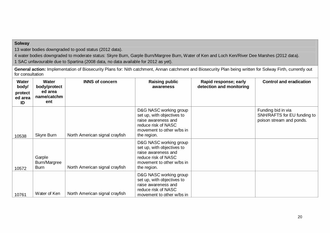
Solway
13 water bodies downgraded to good status (2012 data).
4 water bodies downgraded to moderate status: Skyre Burn, Garple Burn/Margree Burn, Water of Ken and Loch Ken/River Dee Marshes (2012 data).
1 SAC unfavourable due to Spartina (2008 data, no data available for 2012 as yet).
General action: Implementation of Biosecurity Plans for: Nith catchment, Annan catchment and Biosecurity Plan being written for Solway Firth, currently out for consultation
Water body/
protected area
ID
Water body/protect
ed area name/catchm
ent
INNS of concern Raising public awareness
Rapid response; early detection and monitoring
Control and eradication
10538 Skyre Burn North American signal crayfish
D&G NASC working group set up, with objectives to raise awareness and reduce risk of NASC movement to other w/bs in the region.
Funding bid in via SNH/RAFTS for EU funding to poison stream and ponds.
10572
Garple Burn/Margree Burn North American signal crayfish
D&G NASC working group set up, with objectives to raise awareness and reduce risk of NASC movement to other w/bs in the region.
10761 Water of Ken North American signal crayfish
D&G NASC working group set up, with objectives to raise awareness and reduce risk of NASC movement to other w/bs in

21
the region.
100326
Loch Ken/River Dee Marshes North American signal crayfish
D&G NASC working group set up, with objectives to raise awareness and reduce risk of NASC movement to other w/bs in the region.
During 2009, GFT managed a five month research project to increase the understanding of the Loch Ken crayfish population and to investigate possible control trapping of crayfish in Loch Ken
Water bodies adjacent to Skyre Burn, Garple Burn/Margree Burn, Water of Ken and Loch Ken/River Dee Marshes – risk of introduction of NASC
D&G NASC working group set up, with objectives to raise awareness and reduce risk of NASC movement to other w/bs in the region
100326
Loch Ken/River Dee Marshes
Nuttall’s pondweed (Elodea nuttallii)
100330 Milton Loch Canadian pondweed (Elodea canadensis)
100333
Woodhall Loch
Canadian pondweed (Elodea canadensis)
100334 Loch Kindar Canadian pondweed (Elodea canadensis)
100338 Mochrum Australian swamp stonecrop An SNH eradication project
was undertaken but now
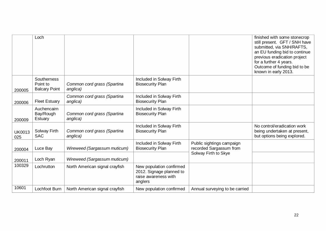
22
Loch finished with some stonecrop still present. GFT / SNH have submitted, via SNH/RAFTS, an EU funding bid to continue previous eradication project for a further 4 years. Outcome of funding bid to be known in early 2013.
200005
Southerness Point to Balcary Point
Common cord grass (Spartina anglica)
Included in Solway Firth Biosecurity Plan
200006 Fleet Estuary Common cord grass (Spartina anglica)
Included in Solway Firth Biosecurity Plan
200009
Auchencairn Bay/Rough Estuary
Common cord grass (Spartina anglica)
Included in Solway Firth Biosecurity Plan
UK0013025
Solway Firth SAC
Common cord grass (Spartina anglica)
Included in Solway Firth Biosecurity Plan
No control/eradication work being undertaken at present, but options being explored.
200004 Luce Bay Wireweed (Sargassum muticum) Included in Solway Firth Biosecurity Plan
Public sightings campaign recorded Sargassum from Solway Firth to Skye
200011 Loch Ryan Wireweed (Sargassum muticum)
100329 Lochrutton North American signal crayfish New population confirmed 2012. Signage planned to raise awareness with anglers
10601 Lochfoot Burn North American signal crayfish New population confirmed Annual surveying to be carried
23
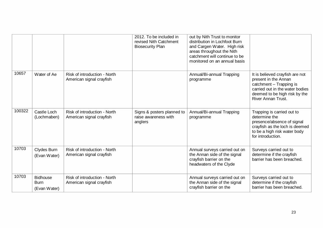
2012. To be included in revised Nith Catchment Biosecurity Plan
out by Nith Trust to monitor distribution in Lochfoot Burn and Cargen Water. High risk areas throughout the Nith catchment will continue to be monitored on an annual basis
10657
Water of Ae
Risk of introduction - North American signal crayfish
Annual/Bi-annual Trapping programme
It is believed crayfish are not present in the Annan catchment – Trapping is carried out in the water bodies deemed to be high risk by the River Annan Trust.
100322 Castle Loch (Lochmaben)
Risk of introduction - North American signal crayfish
Signs & posters planned to raise awareness with anglers
Annual/Bi-annual Trapping programme
Trapping is carried out to determine the presence/absence of signal crayfish as the loch is deemed to be a high risk water body for introduction.
10703 Clydes Burn
(Evan Water)
Risk of introduction - North American signal crayfish
Annual surveys carried out on the Annan side of the signal crayfish barrier on the headwaters of the Clyde
Surveys carried out to determine if the crayfish barrier has been breached.
10703 Bidhouse Burn
(Evan Water)
Risk of introduction - North American signal crayfish
Annual surveys carried out on the Annan side of the signal crayfish barrier on the
Surveys carried out to determine if the crayfish barrier has been breached.
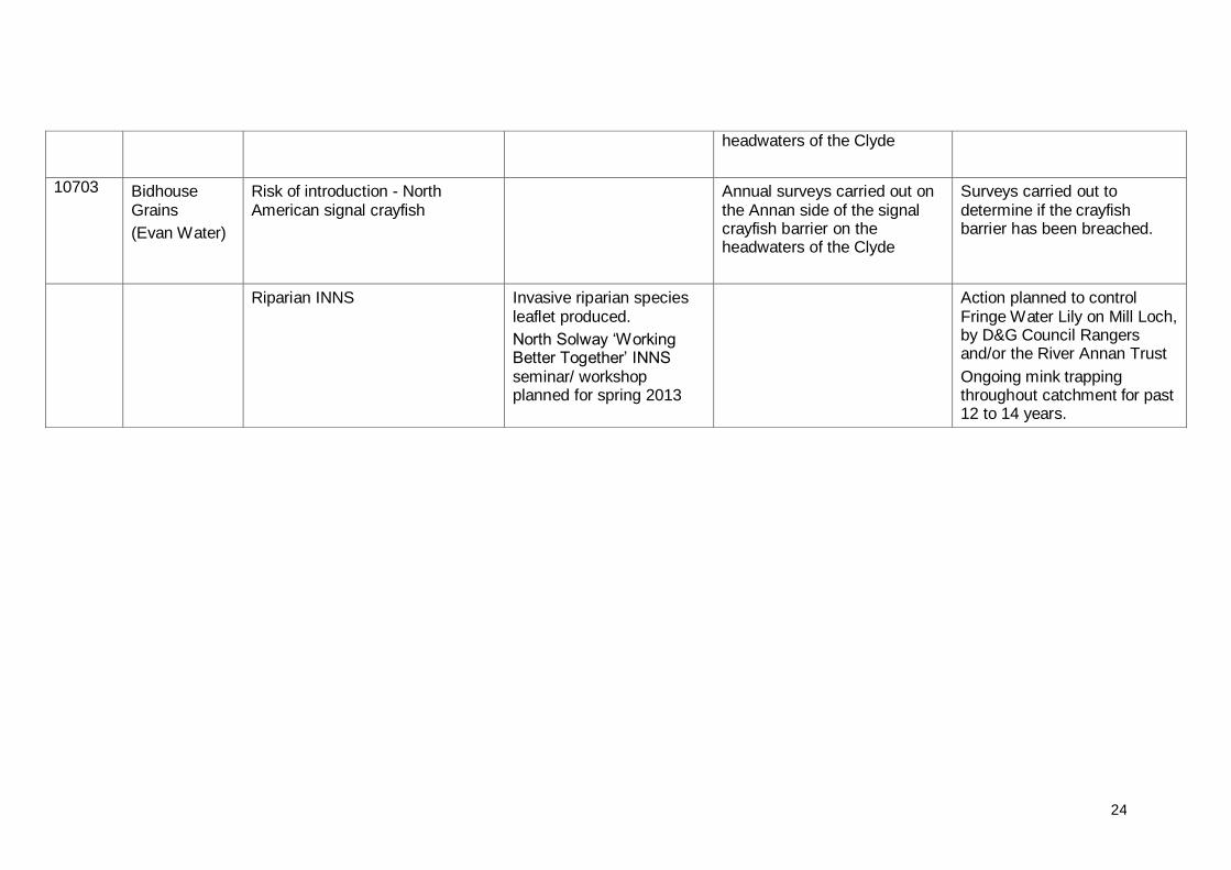
24
headwaters of the Clyde
10703 Bidhouse Grains
(Evan Water)
Risk of introduction - North American signal crayfish
Annual surveys carried out on the Annan side of the signal crayfish barrier on the headwaters of the Clyde
Surveys carried out to determine if the crayfish barrier has been breached.
Riparian INNS Invasive riparian species leaflet produced.
North Solway „Working Better Together‟ INNS seminar/ workshop planned for spring 2013
Action planned to control Fringe Water Lily on Mill Loch, by D&G Council Rangers and/or the River Annan Trust
Ongoing mink trapping throughout catchment for past 12 to 14 years.
25
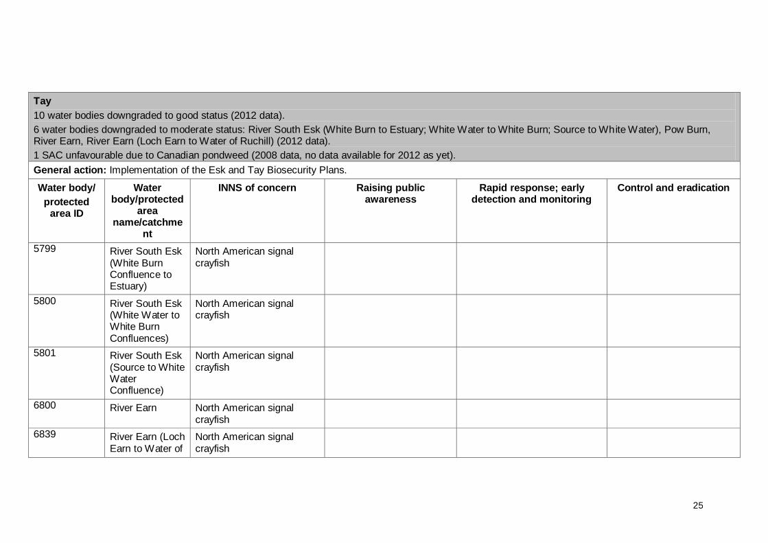
Tay
10 water bodies downgraded to good status (2012 data).
6 water bodies downgraded to moderate status: River South Esk (White Burn to Estuary; White Water to White Burn; Source to White Water), Pow Burn, River Earn, River Earn (Loch Earn to Water of Ruchill) (2012 data).
1 SAC unfavourable due to Canadian pondweed (2008 data, no data available for 2012 as yet).
General action: Implementation of the Esk and Tay Biosecurity Plans.
Water body/
protected area ID
Water body/protected
area name/catchme
nt
INNS of concern Raising public awareness
Rapid response; early detection and monitoring
Control and eradication
5799 River South Esk (White Burn Confluence to Estuary)
North American signal crayfish
5800 River South Esk (White Water to White Burn Confluences)
North American signal crayfish
5801 River South Esk (Source to White Water Confluence)
North American signal crayfish
6800 River Earn North American signal crayfish
6839 River Earn (Loch Earn to Water of
North American signal crayfish

26
Ruchill confluence)
Water bodies adjacent to River South Esk (White Burn to Estuary; White Water to White Burn; source to White Water), River Earn, River Earn (Loch Earn to Water of Ruchill)
Risk of introduction of NASC.
6499 River Tay (R Tummel to R Isla Confluences)
Australian swamp stonecrop
6499 River Tay (R Tummel to R Isla Confluences)
Australian swamp stonecrop
100225 Loch of Lintrathen
Canadian pondweed (Elodea canadensis)
No control/eradication work currently feasible. A review of possible methods has been commissioned by SNH.
100233 Loch Tay Canadian pondweed (Elodea canadensis)
100234 Loch of Drumellie
Canadian pondweed (Elodea canadensis)
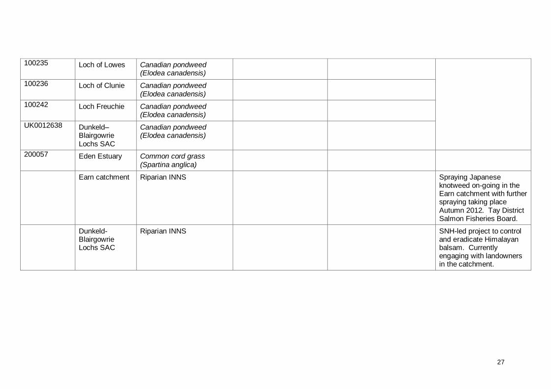
27
100235 Loch of Lowes Canadian pondweed (Elodea canadensis)
100236 Loch of Clunie Canadian pondweed (Elodea canadensis)
100242 Loch Freuchie Canadian pondweed (Elodea canadensis)
UK0012638 Dunkeld–Blairgowrie Lochs SAC
Canadian pondweed (Elodea canadensis)
200057 Eden Estuary Common cord grass (Spartina anglica)
Earn catchment Riparian INNS Spraying Japanese knotweed on-going in the Earn catchment with further spraying taking place Autumn 2012. Tay District Salmon Fisheries Board.
Dunkeld-Blairgowrie Lochs SAC
Riparian INNS SNH-led project to control and eradicate Himalayan balsam. Currently engaging with landowners in the catchment.
28
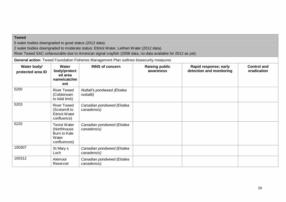
Tweed
5 water bodies downgraded to good status (2012 data).
2 water bodies downgraded to moderate status: Ettrick Water, Leithen Water (2012 data).
River Tweed SAC unfavourable due to American signal crayfish (2008 data, no data available for 2012 as yet).
General action: Tweed Foundation Fisheries Management Plan outlines biosecurity measures
Water body/
protected area ID
Water body/protect
ed area name/catchm
ent
INNS of concern Raising public awareness
Rapid response; early detection and monitoring
Control and eradication
5200 River Tweed (Coldstream to tidal limit)
Nuttall’s pondweed (Elodea nuttallii)
5203 River Tweed (Scotsmill to Ettrick Water confluence)
Canadian pondweed (Elodea canadensis)
5220 Teviot Water (Northhouse Burn to Kale Water confluences)
Canadian pondweed (Elodea canadensis)
100307 St Mary s Loch
Canadian pondweed (Elodea canadensis)
100312 Alemoor Reservoir
Canadian pondweed (Elodea canadensis)
29
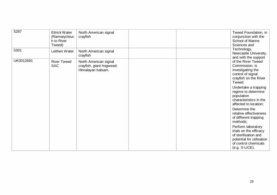
5287 Ettrick Water (Ramseycleuch to River Tweed)
North American signal crayfish
Tweed Foundation, in conjunction with the School of Marine Sciences and Technology, Newcastle University, and with the support of the River Tweed Commission, is investigating the control of signal crayfish on the River Tweed:
Undertake a trapping regime to determine population characteristics in the affected to location;
Determine the relative effectiveness of different trapping methods;
Perform laboratory trials on the efficacy of sterilisation and potential for utilisation of control chemicals (e.g. S-LICE).
5301 Leithen Water North American signal crayfish
UK0012691 River Tweed SAC
North American signal crayfish, giant hogweed; Himalayan balsam.

30
“Un-wanted” posters for 8 different alien invasive species.
Entire Tweed catchment
Riparian INNS
Control and eradication projects.
31
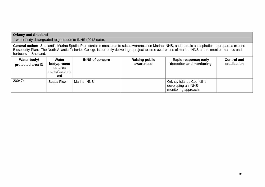
Orkney and Shetland
1 water body downgraded to good due to INNS (2012 data).
General action: Shetland‟s Marine Spatial Plan contains measures to raise awareness on Marine INNS, and there is an aspiration to prepare a marine Biosecurity Plan. The North Atlantic Fisheries College is currently delivering a project to raise awareness of marine INNS and to monitor marinas and harbours in Shetland.
Water body/
protected area ID
Water body/protect
ed area name/catchm
ent
INNS of concern Raising public awareness
Rapid response; early detection and monitoring
Control and eradication
200474 Scapa Flow Marine INNS
Orkney Islands Council is developing an INNS monitoring approach.