MANAGEMENT OF MINERAL RESOURCES OF KARST FIELDS, CASE STUDY OF COUNTY OF DUBROVNIK-NERETVA
14
CROATIAN GEOLOGICAL SURVEY HRVATSKI GEOLOŠKI INSTITUT www.hgi-cgs.hr MANAGEMENT OF MINERAL RESOURCES OF MANAGEMENT OF MINERAL RESOURCES OF KARST FIELDS, CASE STUDY OF COUNTY KARST FIELDS, CASE STUDY OF COUNTY OF DUBROVNIK-NERETVA OF DUBROVNIK-NERETVA Sustainability Sustainability of the Karst Environment - Dinaric Karst and other Karst Regions of the Karst Environment - Dinaric Karst and other Karst Regions 2009 2009 Željko Dedić (1) Slobodan Miko (1) Ozren Hasan (1) (1) (1) Croatian Croatian G eological eological S urvey urvey; Sachsova 2, Zagreb Sachsova 2, Zagreb 10000, Croatia 10000, Croatia
-
Upload
fulton-larson -
Category
Documents
-
view
20 -
download
0
description
MANAGEMENT OF MINERAL RESOURCES OF KARST FIELDS, CASE STUDY OF COUNTY OF DUBROVNIK-NERETVA. Željko Dedić (1) Slobodan Miko (1) Ozren Hasan (1). Croatian G eological S urvey ; Sachsova 2, Zagreb 10000, Croatia. - PowerPoint PPT Presentation
Transcript of MANAGEMENT OF MINERAL RESOURCES OF KARST FIELDS, CASE STUDY OF COUNTY OF DUBROVNIK-NERETVA
CROATIAN GEOLOGICAL SURVEYHRVATSKI GEOLOŠKI INSTITUT
www.hgi-cgs.hr
MANAGEMENT OF MINERAL RESOURCES OF MANAGEMENT OF MINERAL RESOURCES OF KARST FIELDS, CASE STUDY OF COUNTY OF KARST FIELDS, CASE STUDY OF COUNTY OF
DUBROVNIK-NERETVADUBROVNIK-NERETVA
SustainabilitySustainability of the Karst Environment - Dinaric Karst and other Karst Regionsof the Karst Environment - Dinaric Karst and other Karst Regions 2009 2009
Željko Dedić(1) Slobodan Miko(1) Ozren Hasan(1)
(1)(1) Croatian Croatian GGeological eological SSurveyurvey;; Sachsova 2, Zagreb 10000, Sachsova 2, Zagreb 10000, CroatiaCroatia

Geology of CroatiaGeology of Croatia
A D R I A T I C S E A
B o u n d a ry b e tw e e n C a r b o n a te a n d N o n -c a rb o n a te te rr a in s
• >50% carbonate rock
(limestone and dolomite mainly of the Mesozoic Adriatic Carbonate Platform)
• 40 % thick unconsolidated Quarternary sedimentary deposits
• <5% eruptive and metamorphic rocks
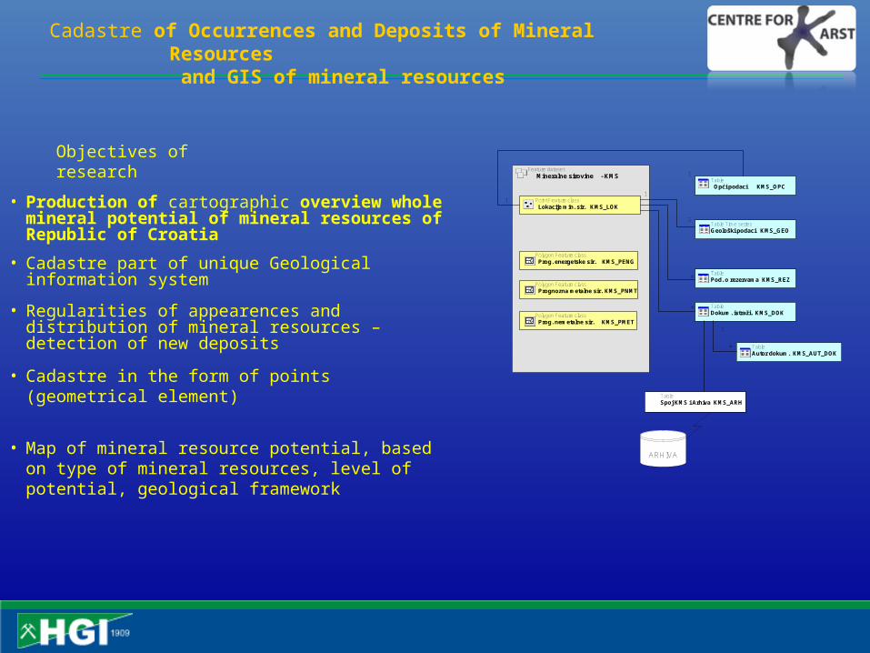
Cadastre of Occurrences and Deposits of Mineral Resources and GIS of mineral resources
Feature dataset
Mineralne sirovine - KMS
Polygon Feature class Prog. energetske sir. KMS_PENG
Polygon Feature class Prognozna metalne sir. KMS_PNMT
Polygon Feature class Prog. nemetalne sir. KMS_PMET
ARHIVA
Table Time seriesGeološki podaci KMS_GEO
TableDokum. istraži. KMS_DOK
Table Opći podaci KMS_OPC
*
Point Feature class Lokacije min. sir. KMS_LOK
1
TablePod. o rezervama KMS_REZ*
1
11
TableAutor dokum. KMS_AUT_DOK
*
1
TableSpoj KMS i Arhiva KMS_ARH
• Regularities of appearences and distribution of mineral resources – detection of new deposits
Objectives of research
• Cadastre part of unique Geological information system
• Cadastre in the form of points (geometrical element)
• Map of mineral resource potential, based on type of mineral resources, level of potential, geological framework
• Production of cartographic overview whole mineral potential of mineral resources of Republic of Croatia
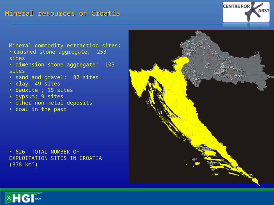
Mineral resources of CroatiaMineral resources of Croatia
Mineral commodity ectraction sites:• crushed stone aggregate; 253 sites• dimension stone aggregate; 103 sites• sand and gravel; 82 sites• clay; 49 sites• bauxite ; 15 sites• gypsum; 9 sites• other non metal deposits• coal in the past
• 626 TOTAL NUMBER OF EXPLOITATION SITES IN CROATIA (378 km²)

• 73 deposits and occurrences of mineral resources• 14 type of mineral resources
• exploitation in 10 quarries of crushed stone aggregates and dimensional stone quarrying at 6 exploitation sites
• exploatation of marine salt, peloids, sands from Neretva river delta
Mineral resources of Dubrovačko-neretvanska countyMineral resources of Dubrovačko-neretvanska county
Mapping geological potential
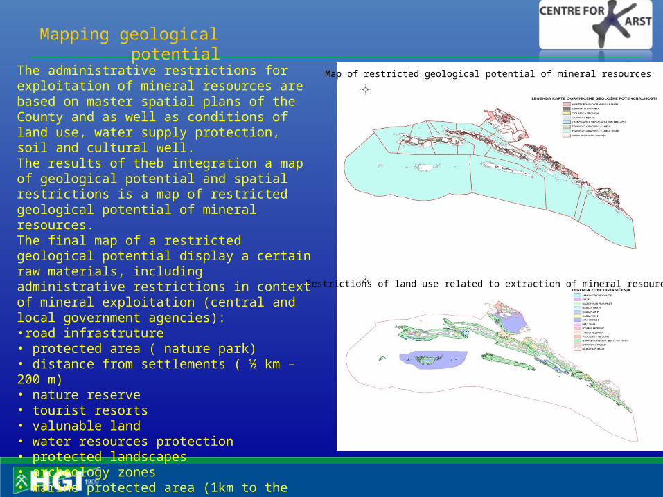
Restrictions of land use related to extraction of mineral resources
Map of restricted geological potential of mineral resourcesThe administrative restrictions for exploitation of mineral resources are based on master spatial plans of the County and as well as conditions of land use, water supply protection, soil and cultural well.The results of theb integration a map of geological potential and spatial restrictions is a map of restricted geological potential of mineral resources.The final map of a restricted geological potential display a certain raw materials, including administrative restrictions in context of mineral exploitation (central and local government agencies):•road infrastruture• protected area ( nature park)• distance from settlements ( ½ km – 200 m)• nature reserve• tourist resorts• valunable land• water resources protection• protected landscapes• archeology zones• marine protected area (1km to the land; 300m to the sea-ZOP)
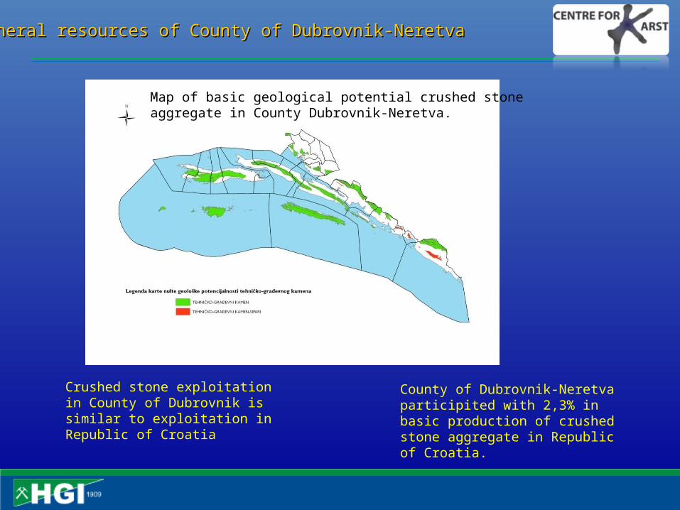
Mineral resources of County of Dubrovnik-NeretvaMineral resources of County of Dubrovnik-Neretva
Crushed stone exploitation in County of Dubrovnik is similar to exploitation in Republic of Croatia
County of Dubrovnik-Neretva participited with 2,3% in basic production of crushed stone aggregate in Republic of Croatia.
Map of basic geological potential crushed stone aggregate in County Dubrovnik-Neretva.

0
5
10
15
20
25
30
35
40
45
Bla
to
Dubro
vačk
oprim
orje
Dubro
vnik
Janjin
a
Konavl
e
Korč
ula
Mlje
t
Ore
bić
Plo
če
Sm
okv
ica
Sto
n
Trp
anj
Vela
Luka
Zabablje
Km
2
TEHNIČKO-GRAĐEVNI KAMEN TEHNIČKO-GRAĐEVNI KAMEN - SIPARI
The largest restricted geological potential of crushed stone aggregates is connected to areas of coast of Dubrovnik, Konavle, Korčula and Orebić
Mineral resources of County of Dubrovnik-NeretvaMineral resources of County of Dubrovnik-Neretva
Area restricted geological potential of crushed stone aggregates per units of local –self goverment per units of local –self goverment ( in km2).
Map of restricted geological potential crushed stone aggregate in County Dubrovnik-Neretva.

Mineral resources of County of Dubrovnik-NeretvaMineral resources of County of Dubrovnik-Neretva
Map of restricted geological potential dimensional stone aggregate in County Dubrovnik-Neretva, in MPA zone
At County of Dubrovnik-Neretva area of geological potential for dimensional stone aggregate amount 562 km², but implementing MPA-a, 239 km² or 43% geological potential zone , cannot be used for investigestion and exploitation. According to authors of strategy of managment of mineral resources of Republic of Croatia (Krasić et al.,2008), restriction gave to mining activities implementation of MPA-a are results inherited weaknesses in the field of activity as well as unknown opurtunities designed and used of enviroment.

udio proizvodnje u RH
Istarska županija35,7%
Splitsko dalmatinska županija
40,4%
Šibensko-kninska županija0,7%
Zadarska županija6,3%
Zagrebačka županija0,5%
Dubrovačko nertvanska županija
16,4%
Production of dimensional stone aggregates in 4 county in Croatia.Production of dimensional stone aggregates in 4 county in Croatia.County Dubrovnik-Neretva with 16% in total value (2005).County Dubrovnik-Neretva with 16% in total value (2005).
Mineral resources of County of Dubrovnik-NeretvaMineral resources of County of Dubrovnik-Neretva
The largest reduced geological potential of dimensional stone aggregates is connected for areas of coast of Dubrovnik, Konavle, Korčula and Orebić, almost 65% of geological potentialof dimensional aggregate stone.
0
10
20
30
40
50
60
Bla
to
Dub
rova
čko
prim
orje
Dub
rovn
ik
Janj
ina
Kon
avle
Kor
čula
Kul
a N
orin
ska
Lum
bard
a
Met
kovi
ć
Ore
bić
Plo
če
Poj
ezer
je
Sto
n
Trp
anj
Vel
a Lu
ka
Zab
ablje
Žup
a du
brov
ačka
Km
2
ARHITEKTONSKO-GRAĐEVNI KAMEN
With strategy of managment of mineral resources of Republic of Croatia within MPA-a recommend admission of mining activities of mineral resources in function of recovery and useful design abundand mining objects. Consenquently proposal which changes will be requested, extraordinary status of same areas for exploatation dimensional stone aggregate within MPA-a, like in case of island Brač. We need initiative from local self-goverment, county department, county economic council, professional group owner of quarries, Croatia economic council county Dubrovnik, Ministry of economy, Labour and Entrepreneurship, Department of mining.
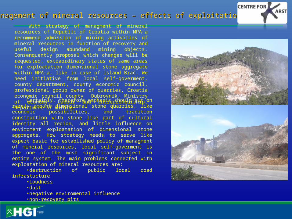
Management of mineral resources – effects of exploitation Management of mineral resources – effects of exploitation
Certainly, therefore emphasis should put on rarely amount dimensional stone quarries, like economic possibilities, and tradition construction with stone like part of cultural identity all region, and little influence on enviroment exploatation of dimensional stone aggregate. How strategy needs to serve like expert basic for established policy of managment of mineral resources, local self-goverment is the one of the most significant subject in entire system. The main problems connected with exploatation of mineral resources are:
•destruction of public local road infrastucture•loudness•dust•negative enviromental influence•non-recovery pits
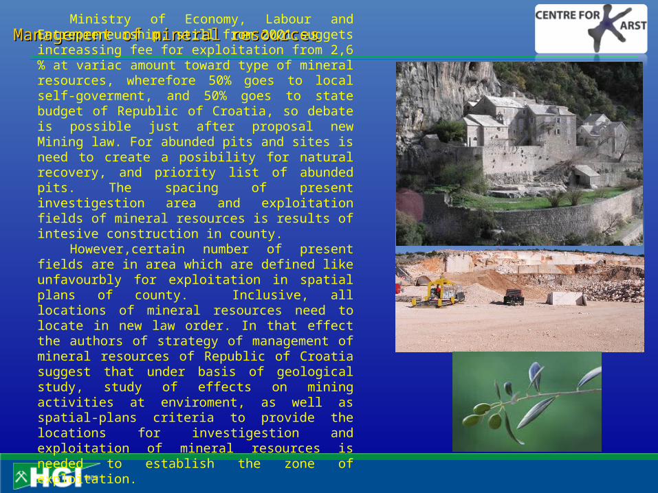
Management of mineral resources Management of mineral resources Ministry of Economy, Labour and
Entrepreneurship, still from 2001.suggets increassing fee for exploitation from 2,6 % at variac amount toward type of mineral resources, wherefore 50% goes to local self-goverment, and 50% goes to state budget of Republic of Croatia, so debate is possible just after proposal new Mining law. For abunded pits and sites is need to create a posibility for natural recovery, and priority list of abunded pits. The spacing of present investigestion area and exploitation fields of mineral resources is results of intesive construction in county.
However,certain number of present fields are in area which are defined like unfavourbly for exploitation in spatial plans of county. Inclusive, all locations of mineral resources need to locate in new law order. In that effect the authors of strategy of management of mineral resources of Republic of Croatia suggest that under basis of geological study, study of effects on mining activities at enviroment, as well as spatial-plans criteria to provide the locations for investigestion and exploitation of mineral resources is needed to establish the zone of exploitation.
Management of mineral resources
SARMa - Sustainable Aggregates Resource Managementhttp://www.sarmaproject.eu/
Project summaryAggregates (crushed stone, sand and gravel) are crucial for infrastructure and construction. SEE countries are rich in aggregates, but supply is not coordinated within or across the area. Challenges are illegal and damaging quarries, unreclaimed sites, limited recycling and community opposition. Fulfilling demand requires efficient and sustainable supply chain (planning, extraction, transport, use and recycling), and socio-eco friendly quarrying, to preclude opposition to extraction, supply bottlenecks, and restricted growth. Main objectives of the project are to develop common approach to sustainable aggregate resource management (SARM) and sustainable supply mix (SSM) planning, at three scales, to ensure efficient and secure supply in SEE. Specific objectives include capacity building, information infrastructure creation, and planning for a Regional Centre on SARM and SSM. Local, site-level activities will focus on environmentally friendly extraction through best practices, reducing illegal quarrying, and recycling to reducing use of primary aggregates. Region/national activities will create a SARM framework for effective management, and define SSM, as well as recommend how to integrate SSM into planning and legislation. Transnational activities focus on harmonization of relevant policies and legislation across SEE, information transfer, and creation of an Aggregates Intelligence System. The project builds the foundation for a Regional Centre on sustainable aggregates management and supply. Main outputs will include capacity building materials: printed materials (manuals) on (1) local level aggregate operation improvements, (2) regional, national and transnational policy, legislation, management and supply mix, (3) C & D waste management, tools, methods (e.g. life cycle analysis); and regional, national and transnational events. Results will include use of best practices, adoption of SARM and SSM, harmonized policies, and ongoing collaboration among partners.

Thank Thank youyou ! !
Thank Thank youyou ! !
Fold in Eocene depositsFold in Eocene depositsA proposed protected geological A proposed protected geological sitesiteKapelj spring, MosećKapelj spring, Moseć
Fold in Eocene depositsFold in Eocene depositsA proposed protected geological A proposed protected geological sitesiteKapelj spring, MosećKapelj spring, Moseć