Management Guidelines For Forestry and Resource-Based … · Management Guidelines For Forestry and...
45
Management Guidelines For Forestry and Resource-Based Tourism TECHNICAL SERIES
Transcript of Management Guidelines For Forestry and Resource-Based … · Management Guidelines For Forestry and...

Management GuidelinesFor Forestry andResource-Based Tourism
TECHNICAL SERIES
Management Guidelines For Forestry and Resource-Based Tourism
Version 1.0
July, 2001.
Tourism Guidelines Working Group
Cette publication technique n’est disponible qu’en anglais.

© 2001 Queen's Printer for Ontario
Printed in Canada
Single copies of this publication are available at no cost from:
Natural Resources Information Centre
300 Water Street
P.O. Box 7000
Peterborough, ON
K9J 8M5
Current publications of the Ontario Ministry of NaturalResources, and price lists are also available from this office.
Telephone inquiries about ministry programs and services should be directed to the Natural ResourcesInformation Centre:
PeterboroughGeneral Inquiry 1-800-667-1940
Renseignements en francais 1-800-667-1840
FAX 1-705-755-1677
Email [email protected]
Other government publications are available fromPublications Ontario, Main Floor, 880 Bay St., Toronto,ON. For mail orders write Publications Ontario, 50Grosvenor St., Toronto, Ontario M7A 1N8
This publication should be cited as:
Forest Management Branch, Management Guidelines forForestry and Resource-based Tourism. Ont. Min. Nat.Res., Queen's Printer for Ontario, Toronto, ON. xxxp.

Acknowledgements
Management Guidelines for Forestry and Resource-based Tourism were prepared during 1998 -2001. A working groupwas established to assist the Ministry of Natural Resources with the preparation of these Guidelines.
The Tourism Guideline Working Group was comprised of:
Jim Antler – Northern Ontario Tourist Outfitters, North BayDave Barker – Ministry of Natural Resources, Field Services Division, GeraldtonHeather Barns – Ministry of Natural Resources, Field Services Division, Sauilt Ste MarieSergio Buonocore – Ministry of Tourism, Culture and Recreation, Thunder BayPaul Glassford - Ministry of Natural Resources , Land Use Coordination, Sault Ste MarieRick Groves – Tembec, TimminsJim Grayston - Northern Ontario Tourist Outfitters , North BayStephen Harvey – Ministry of Natural Resources, Forests Division , Sault Ste. MarieBruce Hyer – Northern Ontario Tourist Outfitters, Thunder BayPaul Jewiss – Abitibi Consolidated, Fort FrancesMike Maxfield – Bowater, Thunder BayBetty McGie – Northern Ontario Tourist Outfitters, WawaJohn McLaren – Mackenzie Forest Products, Sioux LookoutGerry Webber – Ministry of Tourism, Culture and Recreation, SudburyKaren Wianecki - Ministry of Natural Resources, Forests Division Toronto
Many other people in the tourist and forest industries and government provided assistance in the development of theseGuidelines. Special thanks goes out to those who took time from their daily jobs to show off "their part" of the forestincluding, Joe Johnson MNR Parry Sound, Larry Rosebrugh Algonquin Forestry Authority, Marg Watson SudburyAviation, Shane Looby Shooting Star Camps, Harry Pearce Domtar, Darren Tegal Domtar, Mark Jones Cochrane Air,Gord King Norbord Industries, Roy Bennett Kenda Wilderness Lodge, Dick Harlock Gogama Air Outfitters, RogerMulligan Goodbush Forestry Services.
The assistance and input of the Provincial Forest Technical Committee is also gratefully acknowledged.
Thanks to Nancy Houle and Richard Raper of MNR’s Forest Management Planning Section and Jim Steele MNRScience and Information Branch for their patience and assistance.
Management Guidel ines for Forestry and Resource-Based Tour ism
I

Table of Contents
1.0 INTRODUCTION 1
1.1 Background........................................................................................................................................1
1.2 Legislative Framework........................................................................................................................21.2.1 Application of the guidelines ..............................................................................................................21.2.2 Guideline Development Process ..........................................................................................................3
1.3 The Resource-Based Tourism Industry ................................................................................................31.3.1 Resource-based Tourism Industry Resource Values ..............................................................................31.3.2 A New Approach To Protecting Resource-Based Tourism Values ..........................................................41.3.3 Resource-based Tourism Industry - Remote, Semi-Remote & Drive-In ..................................................51.3.4 Forest Management Activities Affecting The Resource-based Tourism Industry ....................................5
2.0 ADVICE TO PRACTITIONERS 6
2.1 Introduction ......................................................................................................................................62.1.1 Environmental Considerations ............................................................................................................62.1.2 Specific Environmental Considerations................................................................................................62.1.3 Contacts And Communications ............................................................................................................72.1.4 Specific Communications Considerations ............................................................................................8
2.2 Consideration For Other Stakeholders ................................................................................................8
2.3 Issue Resolution ................................................................................................................................8
2.4 Science And Economic Research ........................................................................................................8
2.5 Time And Space ................................................................................................................................9
2.6 Visibility Analysis Methods ................................................................................................................9
2.7 Other Considerations ..........................................................................................................................9
2.8 Forest Management Planning – Timetable ........................................................................................10
3.0 TOOLS AND TECHNIQUES 12
3.1 Introduction ....................................................................................................................................12
3.2 Information......................................................................................................................................12
Management Guidel ines for Forestry and Resource-Based Tour ism – TABLE OF CONTENTS
II

3.3 Access Management ........................................................................................................................12
Physical - Tools And Techniques ........................................................................................................133.3.1 Natural abandonment ......................................................................................................................133.3.2 Water crossing removal ....................................................................................................................143.3.3 Physical Removal of Roadbed............................................................................................................163.3.4 Physical impediments3.3.5 Winter Access for Forest Operations ................................................................................................17
Regulatory - Tools And Techniqes ......................................................................................................173.3.6 Signs Restricting Use........................................................................................................................173.3,7 Road Use Permits ............................................................................................................................183.3.8 Gates ..............................................................................................................................................19
3.4 Maintenance of Remoteness ..............................................................................................................19
3.5 Visual Aesthetics/Views ....................................................................................................................193.5.1 "Buffers" and No Harvest Reserves ....................................................................................................203.5.2 Modifying Harvest Patterns To Avoid The "Manufactured Look" ........................................................213.5.3 Partial harvest ................................................................................................................................213.5.4 Early Green-Up ................................................................................................................................213.6.5 Trails or portages ............................................................................................................................22
3.6 Noise Control ..................................................................................................................................22
3.7 Planning ..........................................................................................................................................23
4.0 EVALUATION OF THE EFFECTIVENESS OF THE GUIDELINES 24
Appendix 1 ......................................................................................................................................................25
Tourism And Forestry Industry Memorandum Of Understanding ........................................................................25
Appendix 2 ......................................................................................................................................................31
Map Of Forest Management Units ....................................................................................................................31
Appendix 3 ......................................................................................................................................................33
Mapping Tourism Values ..................................................................................................................................33
Management Guidel ines for Forestry and Resource-Based Tour ism – TABLE OF CONTENTS
III

Executive Summary
Management Guidelines for Forestry and Resource-based Tourism are to be used in the development of forest manage-ment plans for those portions of the forest used for forestry and resource-based tourism. The Guidelines may also beuseful during the development of Resource Stewardship Agreements. Those features of the forest used by the touristindustry are described in the Guidelines in general terms. Measures which may be taken to assist with specific identifi-cation of resource-based tourism values are outlined. The resource-based tourism industry itself is divided into threetypes: drive in, semi-remote and remote. One of the most challenging aspects of managing the interface betweenremote tourism and forestry is the planning of roads and their use. The forest industry requires roads to harvest, renewand, maintain the forest, while segments of the tourist industry need some areas which are "functionally roadless." Theneed to provide the resource-based tourism industry with a "reasonably similar level of remoteness" is recognised in theTourism and Forestry Industry Memorandum of Understanding approved by the Ontario government in 2001. Allresource based tourism business depends in part on a visually forested landscape and a forest that is free from unwantedor disturbing noise. Forest management planners must consider the needs of the tourist industry when developingplans; however, they must also consider a wide range of environmental needs. Both tourism and environmental needsvary by forest type and site. A further challenge for forest management planners is the need to consider the interests ofother stakeholders such as anglers and hunters. The decision to apply a specific technique to protect a tourism value isnot a simple decision.
When the desired degree of remoteness in the forest is determined and other needs of the resource-based tourismindustry established, the task of selecting a specific forestry tool or technique to address the needs of the resource-basedtourism industry follows. Management Guidelines for Forestry and Resource-based Tourism describes a range of practices, tools and, techniques that should be considered when developing forest management prescriptions to protectresource-based tourism values. The information provided is based on operational experience. New and creative tech-niques, which may evolve over time, are encouraged as long as they do not contravene existing legislation. In practice, acombination of techniques usually produces the intended result (e.g. sign erected and culvert removed.) The informationis organised under the headings: Access Management, Visual Aesthetics/Views, Noise Control and, Planning.
These Guidelines are intended for use by both forest management planners and owners/operators of resource-basedtourism businesses. To ensure that readers are able to make best use of these Guidelines extra effort has been taken toexplain how these Guidelines may be used in conjunction with the forest management plan development process. Anumber of "Tips" are contained in the Guidelines. "Tips" are not presented as "direction;" rather, the team which pre-pared the Guidelines felt there was merit to provide information to the user which might be used in any number ofways to assist with managing the forestry/tourism interface.
To ensure the continued effectiveness of forest management plans forest management guidelines should be evaluated.Resource-based tourism values and the methods used to protect these values are most often determined through discus-sions and negotiations between the resource-based tourism industry and forest management planner. Tourism valuesare quite different than other values that are the subject of forest management planning guidelines. Those features ofthe forest important to the tourist industry are not readily inventoried and are not supported by strong science. In factmany of the values used by the tourist industry are business specific; that is to say what may be important to onetourism business may be of relatively little importance to another. The means, then, of determining the effectiveness ofthese Guidelines must consider the effectiveness and efficiency of negotiations with the understanding that neitherparty to these negotiations may be entirely happy with the negotiated outcome but at the least they have what theyrequire to pursue their business interest.
Management Guidel ines for Forestry and Resource-Based Tour ism – EXECUTIVE SUMMARY
IV

Management Guidel ines for Forestry and Resource-Based Tour ism – INTRODUCTION
1
1.0 INTRODUCTION
These Guidelines are intended to assist with planningforestry operations in those parts of Ontario’s forestbeing used for both forestry and tourism. The"Guidelines" will be of interest to members of forestmanagement planning teams who must prepare forestmanagement plans every five years; they will also be ofinterest to the tourist industry. The tourist industrymay find the useful information in the Guidelineswhen participating in forest management planning;opportunities to participate in planning are providedthrough the forest management planning process and,through the newly created opportunity to negotiateResource Stewardship Agreements.
Information in this Guide:
1. Introduces the reader to forest management planning.
2. Defines the general planning needs of the touristand forest industries.
3. Provides practical advice for those involved in planning forestry operations in areas used by thetourist industry.
4. Describes various tools and techniques for protecting resource-based tourism values.
5. Discusses the evaluation of the Guidelines’ effectiveness.
These Guidelines are one source of expert informa-tion. Readers are encouraged to use other sources ofinformation, especially that which can come from theindividual experience of those negotiating ResourceStewardship Agreements and developing forest man-agement plans.
1.1 BackgroundPublic forests in Ontario are managed to produce avariety of benefits. The goal of forest management isto ensure the long-term health of forest ecosystems forthe benefit of local and global environments, whileenabling present and future generations to meet theirsocial and material needs.
All forestry operations occurring within Ontario’s pub-lic forests are directed by a forest management plan.The forest management plan must provide for the sustainability of the forest and have regard to the plantlife, animal life, water, soil, air, social and economicvalues. Forest management plans are produced foreach forest management unit in Ontario; there aremore than 50 management units. Each forest manage-ment plan must consider the needs of a diverse rangeof forest users including those of the resource-basedtourism industry. The process for developing the plansprovides various opportunities for public involvement.
Those responsible for preparing forest managementplans must consult a wide range of planning manualsand guidelines including these ManagementGuidelines for Forestry and Resource-based Tourism.Timber Management Guidelines for the Protection ofTourism Values were first produced and distributed in1987. Much has changed since that time including:
• A new legislative framework: the Crown ForestSustainability Act (CFSA) 1994,
• A new land use strategy: Ontario’s Living Legacy(1999)
• Ontario’s Forest Accord: which enabled the creation ofan extensive parks and protected areas system whilealso considering the needs of the forest industry.
• A Resource-based Tourism Policy (1997) which pro-motes and encourages the development of Ontario’sresource-based tourism industry in an ecologicallyand economically sustainable manner,
• The Tourism and Forestry Industry Memorandum ofUnderstanding (2001) which sets out a process fornegotiating local resource stewardship agreements.
These changes and other business and technology-related changes have resulted in a different approachto forest management on the ground. One of the sig-nificant changes in the approach to forest managementplanning has been the willingness of both theresource-based tourism and forest industries to searchfor ways to address each others’ needs while workingin the same forest.
These guidelines summarise those managementoptions and practices to be considered when develop-ing operational prescriptions in forest managementplans intended to address resource-based tourisminterests or values. The guidelines can serve as a com-mon set of information for both the tourist and forestindustries as they work together to formulate plans forworking in the same forest.
Nothing in these guidelines shall prejudice or affect inany way the treaty and aboriginal rights of aboriginalpeople in Ontario.
1.2 Legislative frameworkForest management on crown land is the responsibilityof the Minister of Natural Resources through theCFSA. The Class Environmental Assessment for TimberManagement on Crown Lands in Ontario was approvedin1994. Both of these pieces of legislation govern howforest management takes place on Crown land. TheCFSA provides for the sustainability of crown forestsand in accordance with that objective, to managecrown forests to meet social, economic and environ-mental needs of present and future generations.
Under the CFSA there are four manuals, which fur-ther explain how forest management is to take place.One of these is the Forest Management PlanningManual (FMPM), 1996 which outlines the process andgives the format that must be followed in order for aforest management plan to be prepared and approved.These plans are prepared for every forest managementunit where forestry operations are to take place; theyare prepared every five years and consider the needs ofthe forest for the next 20 years.
Another manual, the Forest Operations and SilvicultureManual (1995) requires that these guidelines –Management Guidelines for Forestry and Resource-based Tourism 2001- as well as many others for otherforest values, be considered during the preparation andimplementation of forest management plans.
The class Environmental Assessment for TimberManagement on Crown Lands in Ontario wasapproved in 1994 with the condition that Guidelinesand other implementation manuals be reviewed andrevised as required.
The other two manuals are the Scaling Manual andthe Forest Information Manual.
All forestry operations, which are planned to addressresource-based tourism values, must follow the legaldirection set out in the CFSA.
Licensing of resource-based tourism establishments isthe responsibility of the Minister of Tourism throughthe Tourism Act and Regulation 1037. This legislationprovides the legal basis for which resource-basedtourism businesses are eligible a resource stewardshipagreement (RSA).
1.2.1 Application of the guidelines
These guidelines are intended to provide assistance anddirection to resource-based tourism and forest industryinterests when they are involved in forest managementplanning or the development, implementation, andmaintenance of a RSA. Ontario’s Living Legacy, theResource-Based Tourism Policy and the Tourism and ForestryIndustry Memorandum of Understanding (MOU), and itsassociated Guide to resource Stewardship Agreements, areimportant documents for consideration when planningfor forestry and resource-based tourism.
The guidelines may be considered when writingresource stewardship agreements and must be consid-ered when writing forest management plans when thedecision to conduct forest management operations mayaffect a resource-based tourism industry’s operations.The guidelines contain a variety of techniques and bestpractices that will help to operationalize forestry in afashion which addresses the tourist industries needs inthe forest. These, used alone or, in any combination,can contribute to the tourists’ perception of wildernessand remoteness. While, the guidelines, alone, cannotdeliver remoteness and wilderness since these are inpart, perceptually based values, which vary from oneindividual to another, they can assist in maintainingremoteness.
These guidelines and, forest management plans, takedirection from Ontario’s Living Legacy and other landuse planning documents. Land use planning determineswhere forest management can take place; forest man-agement planning, then, directs how forestry will takeplace on lands selected for this purpose.
Management Guidel ines for Forestry and Resource-Based Tour ism – INTRODUCTION
2
These guidelines do not cover every possible techniqueor practice nor do they consider every situation. Indeed,it is understood that the forest that supports the touristindustry varies considerably across the province, as do theneeds of individual tourist businesses. It is also under-stood that, unlike values addressed in other forest man-agement guidelines such as moose or osprey, the touristindustry is best able to speak for itself and to identify itsneeds on a case-by-case basis. Management Guidelines forForestry and Resource-based Tourism do not provide theanswer for addressing all concerns in all situations, butthey are a source of expert and objective advice.
During preparation of a forest management plan, it isnecessary to document how decisions are made. Thisapplies to all sections of the FMP, including the area ofconcern (AOC) prescriptions and analysis of accessalternatives.
At the option of the parties involved, it may be useful toinclude all, or part, or a summary, of an RSA as anappendix to an FMP.
In all cases where an RSA has influenced the developmentof an AOC or the selection of an access alternative, theFMP will explicitly reference the RSA as a source ofdirection and as rationale for the selectedprescription/alternative.
The FMP will expressly state that the terms of any RSAdo not bind or limit the Minister’s right to make landuse decisions for crown land in Ontario.
1.2.2 Guideline Development Process
These guidelines were written as a co-operative effortamong the resource-based tourism and forest industriesand the Ministries of Natural Resources and Tourism.The group considered the information that came out ofthe Tourism and Forestry Industry Memorandum ofUnderstanding development process.
1.3 The Resource-Based Tourism Industry
1.3.1 Resource-based Tourism industry resource values
The key to a successful resource-based tourism industryis one that provides those experiences that match visitors’expectations. The Memorandum of Understanding(MOU) signed between the forest and resource-basedtourism industries recognizes the importance of:
• Natural aesthetics;
• Remoteness, including maintenance of traditionalmeans of access;
• Maintenance of the perception of wilderness, includ-ing minimization of noise;
• Sustainability and enhancement of fish, game andwilderness opportunities necessary for tourism oper-ations; and
• Maintenance of the perception of Ontario as a worldclass wilderness tourism destination.
The MOU also recognizes that there are elements thatare critical for the success and viability of the forestindustry:
• Minimize the cost of wood delivered to the mill;
• No long term reduction in the supply of fibre and timber;
• Security and accessibility of fibre and timber supply;
• Sustainability of the forest resource for future generations;
• Protection of other forest values; and
• Management of the forest resource in accordancewith legislative and policy requirements governingforest management planning in Ontario.
• Sustainability and enhancement of fibre supply, timber supply and forestry opportunities necessaryfor forestry industry viability.
Management Guidel ines for Forestry and Resource-Based Tour ism – INTRODUCTION
3

In addition, the MOU refers to ‘functionally road-less’ and ‘reasonably similar level of remoteness’.They may be defined as follows:
Functionally roadless
Functionally roadless areas are areas where roads aregenerally discouraged and may be prohibited exceptfor forest management purposes.
These roads are generally constructed to the loweststandard possible (e.g. tertiary roads, winter roads),routed to facilitate decommissioning, and/or restrictedto specific activities and uses. These functionally roadlessareas would normally be maintained to provide for, andpromote, a tourism value that may be negativelyaffected by permanent, public road access.
Reasonably similar level of remoteness
Parties agree in RSA negotiations to apply prescriptionsto protect specific tourism values. Where the tourismoperator has identified remoteness as a value to be pro-tected, then the prescriptions identified in the tourismguidelines shall be applied to maintain a reasonably similar level of remoteness as existed prior to forest man-agement operations. The prescriptions to be consideredwill include, but are not limited to: no harvest areas;functionally roadless strategies; modified operations.
* Excerpt from Tourism and Forestry Industry MOU 2001
For example, if agreed to in an RSA, a tourism valuehas the same level of remoteness at the end of a five-year forest management plan term as it did at thebeginning of the same term.
A reasonably similar level of remoteness is where thetourism value involved, has the same level of remote-ness on the ending benchmark date as on the begin-ning benchmark date. The beginning benchmark dateis a date agreed by the parties. It may be the beginningdate of the five-year term of the next FMP, or someother date, but cannot be earlier than the date the RSAis signed. The ending benchmark date is any later dateagreed by the parties. It may be the ending date of theFMP term, or some other date.
Remoteness means accessibility; in other words, accessto the value should be limited to the same methodsand be similarly easy or difficult on the ending date asit was on the beginning date.
Most resource-based tourism values require touristoperator identification and range in their value orimportance according to the success of the business theysupport. In considering what is an important value, theessential question is: which resource features are impor-tant to the enjoyment of the experience sought? Theseinclude not only specific resources of interest to tourists(e.g. high quality fishery, abundant wildlife, etc.) but alsothe conditions under which the experience is enjoyed(e.g. remoteness, water quality, healthy ecosystems,surrounding scenery and, accessibility).
Resource-based tourism values may also be time spe-cific from a seasonal or daily perspective. For instance,a fish or hunting resource may be very important to aresource-based tourism establishment however, it canonly be used while the resource is legally ‘in season’ orwhen the success rate of securing the resource is high(e.g. generally, speckled trout and or lake trout fishingsuccess is much higher in the spring and fall – not inthe summer months). Other values may only be usedduring a portion of a day, such as a hiking trail or alake used for fishing or viewing wildlife, but not forovernight excursions.
Part of the RSA and FMP process is mapping theresource-based tourism values. "Criteria for mappingresource-based tourism values" found in the Guide toResource Stewardship Agreements (2001) has beenproduced to assist the RSA process. It may also assistthe FMP process. It describes in detail what resource-based tourism values will be mapped by MNR .
1.3.2 A New Approach To ProtectingResource-Based Tourism Values
Managing the resource-based tourism/forestry inter-face can be a challenge. When the forest and resource-based tourism industries enter into discussions regard-ing future forest operations around resource-basedtourism facilities, both industries are dealing with mat-ters of significant value to their operations.
Experience has shown that parties may move quicklyto establish what is necessary to protect their interestswithout fully understanding the other party’s interest.When this happens, meaningful discussions and nego-tiations are often difficult, time consuming, and maynot be as successful for either party. Timely and
Management Guidel ines for Forestry and Resource-Based Tour ism – INTRODUCTION
4

creative discussions, where both understand eachother’s interests, are often more rewarding for bothparties and enable the flexibility required to accommo-date both interests.
1.3.3 Resource-based Tourism IndustryProducts - Remote, Semi-Remote &Drive-In
The resource-based tourist industry itself can be dividedinto three broad categories: remote, semi-remote anddrive-in operations. The following definitions are con-sistent with and derived from Ontario’s "Resource-basedTourism Policy Information Bulletin #1 – May 1998."
1. Remote Resource-based tourism - a tourismresource, opportunity, value or potential developmentthat is not accessible by road and is based on aremote wilderness experience where access is onlygained through air, water or rail. The importantattributes of this product include inaccessibility, isola-tion from visual and auditory impacts, and high quali-ty environmental resources (e.g. fish and wildlife).
2. Semi-remote Resource-based tourism - similarto a remote resource-based tourism opportunityexcept that road access is limited and may be con-trolled through artificial means or the use may belimited to protect the resources, opportunity orvalue. The non-traditional means of access include:restricted road, ATV trail, marine1, and portage2.The same attributes that are important to remoteresource-based tourism are important here as well,except as how they are changed by the lesseramount of remoteness.
3. Drive-in resource-based tourism - includesunencumbered road access in regards to the use ofthe resource-based tourism resource. Importantcharacteristics of this resource include full accessi-bility, composite use3, maintenance of both thevisual and auditory environmental setting4 andaccess to good quality resources5.
1 Marine refers to traditional waterway access.
2 Portage refers to canoe routes3 Composite use refers to two or morecompatible uses co-existing in proximity to one another
4 Refers to the protection of skyline areas of concern and man-madenoise abatement
5 Refers to the importance of having access to ecologically sustainable land,
1.3.4 Forest Management Activities AffectingThe Resource-based Tourism Industry
In section 1.3.1, values that are important to theresource-based tourism and forest industries were discussed.
Some tourism values such as those related to the sustainability of a fishery or moose population areaddressed in other forest management guidelines.
Those tourism values which are more socially basedand are key to the management of effects at theresource-based tourism/forestry interface are the subject of the Management Guidelines for Forestry andResource-based Tourism. Issues associated with these values commonly emerge around the following areas:
• Access impacts (e.g. access to previously remotelakes or rivers).
• Visual impacts (e.g. harvest areas or logging roads,visible from a resource-based tourism lake or waterbody);
• Sound impacts (e.g. noise from equipment or haultrucks, heard at a remote resource-based tourismoutpost camp.)
These categories are based upon predictable impacts,which have been expressed by remote resource-basedtourism industry representatives. The "remote" or"wilderness" character of an area is largely a factor ofthe relative presence or absence of visual, sound andaccess impacts caused by forest management opera-tions or some other user or use.
In many cases, access related issues are the key concernof resource-based tourism industry and can be verytricky to adequately address. Critical attention must beprovided to finding solutions to access related effectsof forest management on the resource-based tourismindustry. It should also be noted that where accessrelated prescriptions fail to have the desired effect,immediate action must be taken to remedy the situa-tion. This need to ensure that the intent or objectiveof the prescription is upheld is referred to by some as the "maintenance component" of an access relatedprescription.
Management Guidel ines for Forestry and Resource-Based Tour ism – INTRODUCTION
5

2.0 ADVICE TO PRACTITIONERS
2.1 IntroductionThis section of the guidelines document has been pre-pared because there will be a wide variety of experi-ence among forest planners and stakeholders who willbe working toward preparing prescriptions for forestryoperations in the vicinity of resource-based tourisminterests.
The information presented defines the range of itemsthat must be considered when developing a forestmanagement plan or a resource stewardship agree-ment. After reading this section of the Guidelinesreaders may be more aware of the complexity of forestmanagement planning. This section also contains somepractical advice for those planning forestry operationsaround tourism values.
2.1.1 Environmental Considerations
In developing guidelines to help determine how forestoperations would be conducted in the area of concernsurrounding a resource-based tourism value, practi-tioners must consider the impacts upon ecosystemdiversity and the environment - as well as the oftenmore obvious impacts upon the social and economicvalues. Many other guidelines have been developed toassist practitioners in forest management planning.These other guidelines must also be considered whiledeveloping prescriptions to address resource-basedtourism values.
Since these guidelines are being prepared for use prima-rily within two forest zones in the province, it is neces-sary to understand the basic ecological processes, whichfoster plant community succession in these zones.
• Boreal Forest
Forest tree species have generally evolved to formstands of trees all of the same age, which becomeestablished following a disturbance – generally fire-and very often of a relatively large size. Other dis-turbances are caused by insect attack and wind, butthese normally create fuel conditions conducive towild fire relatively shortly afterward.
The age class structure of any given forest area willbe variable. One would usually find that younger ageclasses would cover a larger percentage of the landarea than older age classes. In terms of ten-year ageclasses, one could expect a progressive ratio whereeach older age class would have somewhat less areathan the age class one step younger. Relatively littlearea would likely be older than 100 years and thatwould be dominated by the forest stands growing onwetter site conditions and often consisting of blackspruce and mixtures of black spruce, cedar and larch.Older stands may also persist in areas protected fromfrequent fire by geography.
• Great Lakes – St. Lawrence Forest
Forest tree species have evolved to create a widerrange of conditions with regard to forest cover andage structure. There are more tree species presentand there tends to be more canopy structure in manystands. Stands which are even-aged and comprised ofone or two species are relatively less common.
Many stand conditions do originate with a distur-bance. The disturbances are usually of a relativelysmall size (fire, wind, single tree mortality) and cre-ate openings, which provide a variety of light, mois-ture and seedbed conditions on the forest floor.
There are some species, which thrive in the under-story and have the potential to create self-perpetu-ating forest cover over very long time periods.There are, however, other species, which dorequire larger openings in the canopy to createground level conditions that allow them to takeadvantage of full exposure to sunlight.
2.1.2 Specific Environmental Considerations
In determining a set of operational prescriptions for agiven value or set of values it is necessary to consider,in addition to the desires of the economic stakehold-ers, environmental considerations as outlined in theother forest management planning guidelines.
In most cases the operational prescription described insection 3 will require that a combination of tools andapproaches will be implemented as a package. It isexpected that several tools and approaches will be usedto address protection of the value(s) – however, youwould not likely require the use of the full suite of
Management Guidelines for Forestry and Resource-Based Tourism – ADVICE TO PRACTITIONERS
6

tools and approaches for every value. Local circum-stances will determine the appropriate range of toolsand techniques to utilise.
Any operational prescription which proposes to reservean area from forest harvesting, when coupled withactivities which would also prevent natural disturbance(i.e. active fire suppression), should be made with theknowledge of potential future impacts on the naturalforest condition.
Similarly, any operational prescription which proposesselection harvest or partial removal should only bemade after evaluation of the characteristics of the for-est trees on the site and an analysis of potential futurevegetative conditions. Certainly these are effective pre-scriptions in some situations.
The plant and wildlife species have evolved to respondto natural cycles of disturbance, which creates theoverall forest structure.
Solutions proposed by individual stakeholders or smallgroups of stakeholders must ultimately be shown to beconsiderate of issues such as habitat, diversity, ecosys-tem relationships and soil/site capabilities.
Forested ecosystems are very complex relationships ofsoil, moisture, nutrients, bacteria, fungi, plants, inver-tebrate wildlife species and vertebrate wildlife species.These natural complexities are further complicated byour desire to achieve economic and social objectivesfrom the use of our forested and aquatic areas.
Vegetation communities will change on every site overtime. It is necessary to consider an overall strategy tomanage this change as you consider the operational prescriptions that will be used within a forest manage-ment plan.
2.1.3 Contacts And Communications
The preparation of a forest management plan requires a significant commitment of resources to ensure successful completion.
In simplified terms the tasks include:
• Assembling a multi-disciplinary planning team andlocal citizen committee;
• Assembling data and background information (i.e. forest stand information, resource values);
• Identifying and verifying tourism values ;
• Modelling for future tree and wildlife species;
• Analysis of management alternatives;
• Identifying potential forest operating areas;
• Identifying and meeting with stakeholders;
• Developing prescriptions to protect values;
• Documentation of decisions and writing plan details;
• Preparation of maps and display material;
• Public consultation.
The plan author and other members of the planningteam must identify, early in the plan preparation period,the resource values, the values of stakeholders, the stake-holder identities, preferred and optional operating areas.
All participants must recognize that there are timing andavailability constraints upon both resource-based tourismoperators (busy seasons, marketing shows, etc.) and planauthors (information centres, data updates). It is oftennecessary to establish individual strategies to maintaineffective communications between participants.
The plan author and other members of the planningteam must also learn about the factors that influenceguests of the resource-based tourism facilities whenselecting a holiday package.
In the development of a RSA the plan author will contact each resource-based tourism stakeholder in thelicence area to begin discussions that will allow:
• A sharing of information;
• The establishment of a working relationship;
• The identification of values of each party;
• A proactive approach to resolving issues that arise;
• Maximum flexibility to plan operations and pre-scriptions to minimize and mitigate impacts;
• Avoidance of "last minute" issues that delay planproduction and cause conflict with stakeholders.
Participation in the planning process also requires a significant commitment from other resource stakeholders.
Management Guidelines for Forestry and Resource-Based Tourism – ADVICE TO PRACTITIONERS
7

Many stakeholders view participation in the FMPprocess as time away from more important and press-ing aspects of their business. In order to participateeffectively it is necessary to set aside time to:
• Acquire a basic understanding of resource planning;
• Acquire a basic understanding of the dynamics ofthe vegetative communities surrounding theresource-based tourism values;
• Understand those values which are important tothe resource-based tourism business;
• Learn about forest industry operating practices andthe capabilities of forest machinery;
• Accept a joint responsibility to meet with the planauthor and other persons involved in plan prepara-tion;
• Participate in public consultation opportunities;
• Assist in the development of prescriptions to pro-tect values;
• Maintain thorough records of the discussions heldand of input provided to the planning process.
2.1.4 Specific Communications Considerations
Key to any successful planning is the need for thoseinvolved in planning to establish an effective workingrelationship early in the planning process. Part ofmaintaining this relationship is maintaining communi-cations throughout the plan preparation process andduring the plan operating period.
The forest industry and the resource-based tourismoperator must identify, early in the process, those val-ues, which are of significance to their respective opera-tions and must share that information with each otherand with the planning team. At the same time, bothparties should be prepared to express to each other thetools and techniques that they would like to utilize toensure that their respective values are addressed.
2.2 Consideration For OtherStakeholders
The development of forest prescriptions to protectresource-based tourism values must address the inter-est of the other stakeholders who use Crown land that
is designated as "general use area" or "enhanced man-agement area" in Ontario’s Living Legacy.
Furthermore, resource based tourism facilities may belocated in close proximity to each other and, therefore,prescriptions to protect the values of one, must alsoconsider impacts upon a nearby facility.
2.3 Issue ResolutionThose developing prescriptions for the protection ofresource-based tourism values must work together todevelop the means to minimize negative impacts uponeach other’s respective operations while consideringthe needs of other stakeholders, habitat, ecosystemdynamics and resource sustainability.
The most effective planning occurs where participantsidentify the issues early and take steps to develop aprescription that fairly balances the values of eachparty, while being operationally feasible over the longterm. This will often be difficult sometimes and, theremay be issues that may have to be taken to independ-ent parties for the provision of additional information,mediation, arbitration, or issue resolution.
In those cases it is important to consider the following:
• Focus on the issue;
• Preserve the relationship so that future issues donot become clouded by issues that have gonebefore;
• Seek to understand and then to be understood; donot hesitate to ask for additional information;
• Deal with the resolution of the issue as soon as it isapparent that an impasse has been reached (sittingon an outstanding issue for last minute resolutionwill normally prove counterproductive for both parties.)
2.4 Science And EconomicResearch
Several research projects have been carried out to helpdevelop an understanding of the economics ofresource-based tourism operations and the factors thatinfluence guests purchasing decisions.
Management Guidelines for Forestry and Resource-Based Tourism – ADVICE TO PRACTITIONERS
8
The resulting papers are held by various agencies,including:
• Ministry of Natural Resources
• Ministry of Tourism, Culture and Recreation
• Ministry of Economic Development and Trade
• Ministry of the Environment
• Ministry of Northern Development and Mines
• Various universities
Much of this research information is based upon stud-ies of behaviour, social interactions, attitudes and upon statistical databases. This research may have limiteduse to the development of specific prescriptions forforestry operations.
2.5 Time And SpaceIn considering prescriptions to use in carrying out forestoperations and mitigate impacts upon resource basedtourism facilities, it is essential that parties recognize thattime and space are at the heart of the available tools.
Time:
• Are forest or resource-based tourism operations to belimited to specific times of the year? Times of the day?
• Are other forest users to be restricted from use ofan area during specific times of the year?
• Should forest operations be conducted in a shorttime frame (i.e. – one forest management planterm) or spread over a longer time period?
• How long are certain roads or crossings to be maintained?
• How long does it take for the forest to "green up"after harvest operations?
Space:
• Are buffers prescribed for some values?
• Are there natural barriers which could be helpful incontrolling access; how can these be used?
• Selection of the location for barriers to access.
• Are there restrictions as to how close operationscan occur to values during certain time periods?
• Use of terrain features to minimize visual impacts.
• Use of harvest patterns to minimize visual impacts.
2.6 Visibility Analysis MethodsWhen considering the need to protect a view oneshould undertake some form of visibility analysis whichis based on those views enjoyed by guests of a resource-based tourism establishment or by recreational users.Those views can be outlined on a map. Area of concern(AOC) prescriptions are then developed during the forest management planning process.
There are computer-assisted models, which use elevationand forest information to efficiently identify potentialviews. The information from these models should beground-truthed. Others find it useful to go directly to thefield to identify views without first using a computermodel to identify potentially susceptible or sensitive areas.
There are many analysis tools (software products, aircraft,watercraft, etc.) available, which allow resource managersto project and analyse the impacts of operations.
Some of these tools allow managers to:
• Make realistic projections of the view from water orground level locations.
• Make realistic projections of the view from positions above the forest.
• Place roads or harvest depletions on the "land" and"view" the impacts from various perspectives
• Allow the forest to "grow" and project vegetationcover appearance over time.
• Carry out field inspections
These tools may provide additional information forforest planners and resource-based tourism operatorsto use, in support of their knowledge of the local cir-cumstances, to improve operational prescriptions.
2.7 Other ConsiderationsChanging technologies
Snowmobiles and all terrain vehicles (ATVs) haveimpacted the ability of forest managers and resource-based tourism operators to develop effective opera-tional prescriptions. These changes have alreadyoccurred and have created impacts that must now bedealt with. The prudent forest planner and resource-
Management Guidelines for Forestry and Resource-Based Tourism – ADVICE TO PRACTITIONERS
9

based tourism operator are now taking note of emerg-ing technologies and trends to prepare in advance forchanges that will no doubt occur.
As a result of the Ontario Forest Accord, intensive for-est management is being investigated as an approach tomitigate or offset wood supply impacts arising fromOntario Living Legacy decisions, and to aid in the creation of future parks. It will be important that theforest industry planners share their intentions for intensiveforest management with resource-based tourism operatorsduring development of operational prescriptions.
Winter recreation
Modern snowmobiles are much more reliable andfaster than earlier models. These features, when com-bined with improved clothing materials and othertools, which make it safer to travel in the forest duringcold weather, have encouraged more participation inoutdoor winter recreation.
Again, this shift in recreational use patterns has createdadditional challenges for forest planners as they develop operational prescriptions for forest harvestingactivities.
2.8 Forest Management Planning –Timetable
It is important for everyone who has an interest in forestmanagement planning to understand the stages of workwhich are done leading up to the approval of the plan.
Forest management planning is a very lengthy process.This section describes the five-stage public consultationprocess.
Forest management plans are normally implementedon April 1 of a given year, following approximately 2.5years of preparation. For the purpose of this discussionconsider plan implementation as time 0 and refer toother times as months prior to implementation (exam-ple: time 0 is April 1, 2010 – therefore month 18 isOctober, 2008). Since time lines vary somewhat foreach planning team parties should consult with thelocal MNR or forest companies to obtain a more specific schedule.
On the majority of forest management units in Ontariothe forest industry is responsible for operations in theforest as defined in the conditions of their SustainableForest Licence. This includes preparation of the forestmanagement plan. MNR’s role in planning is to pro-vide advice, provide information as set out in the ForestInformation Manual, review planning work and,approve the plan. The interests of the resource itself aswell as those of all resource users must be considered indetermining the suitability of the plan.
Stage 1 – Invitation To Participate – Month 27(January 2008 For A 2010 FMP)
The purpose of this stage is to make the public awarethat the forest management planning process is about tobegin. The background information is available forreview and that the public can inspect the backgroundinformation for the purpose of verifying that their valuesare accurately represented in the MNR database (whichis shared with the plan author and planning team).
At this point, the planning team will have beenformed. It usually includes representatives from theforest companies operating on the licence, MNR rep-resentatives and a member of the Local Citizen’sCommittee. It may also include representatives of keystakeholder associations or communities.
The invitation to participate will be advertised throughnewspaper notices and through mailed notices to thosewho are on the existing mailing list. Stakeholdersshould visit the MNR office to review the backgroundinformation and provide input.
Stage 2 – First Information Centre – Month 20 –18 (August To October 2008 For A 2010 FMP)
The purpose of this stage is to present proposed pri-mary road corridor alternatives; optional harvest areaswith preferred ones highlighted; management unitobjectives; strategies to achieve objectives; analysis ofmanagement alternatives; preliminary preferred man-agement alternative; and draft silvicultural ground rules.
The information centre(s) will be advertised at least 30days in advance. After the presentation there is a 60-day period to review the material and provide com-ment and additional information.
Management Guidelines for Forestry and Resource-Based Tourism – ADVICE TO PRACTITIONERS
10

Those with an interest in the forest should ensure thatthey review the information presented and verify thattheir values have been accurately represented. Thesestakeholders should be working with the plan authorand the planning team to provide input and to addressissues that are outstanding.
Stage 3 – Second Information Centre – Month 16 – 12 (January to April 2009 For A 2010 FMP)
The purpose of this stage is to present specific harvestareas (with areas of concern identified); secondary andprimary roads for the five year operational period;locations where tertiary roads may not be built; theselected management alternative; and areas selected forrenewal and tending.
The information centre(s) will be advertised inadvance. After the presentation there is a 60-day peri-od to review the material and provide comment andadditional information.
Again, stakeholders should ensure that they review theinformation presented to verify that their values havebeen addressed accurately. If there are any issues stilloutstanding, stakeholders should ensure that they areresolved at this time. Any direction agreed to by theforest management planning team should be fully andaccurately documented in the plan and included in theoperational prescriptions.
Stage 4 – Draft Plan – Month 7- 5 (September ToNovember 2009 For A 2010 FMP)
The entire draft plan will have been presented toMNR in month 9. MNR staff will have been carriedout an intensive internal review of the plan prior tomaking it available for public review.
The opportunity for public review will be advertised inadvance. There may be information centres plus a 60-dayreview period or there may be only a 60-day review period.
During the review period, the entire draft plan will beavailable, along with the preliminary list of requiredalterations that MNR identified during their internalreview.
Once again, stakeholders should ensure that theyreview the information presented to verify that theirvalues have been addressed accurately. Ensure that anyagreements that you have with the plan author are
fully and accurately documented in the plan andincluded in the operational prescriptions.
If there are outstanding issues that have not yet beenaddressed, the stakeholder should inform the planauthor and the MNR district manager immediately sothat resolution is achieved as soon as possible.
Stage 5 – Notice Of Approved Plan Inspection –Month 3 (January 2010 For A 2010 FMP)
At this time the entire plan is deemed complete byMNR and is thus approved.
The purpose of this stage is to present it in it’s finishedformat for public inspection. This gives stakeholdersan opportunity to see all of the components and toview the details of the planned operations.
The opportunity for public inspection will be advertised.
If a stakeholder feels that there are significant environ-mental issues that have not been properly addressed inthe plan, this inspection period provides the final oppor-tunity to ask the Ministry of the Environment for a"bump-up" to an individual environmental assessment.
The Forest Management Planning Manual (FMPM) isa manual regulated under the CFSA which providesdirection for plan development and implementation.The FMPM provides the legal basis for plan develop-ment and should be referred to for the authoritative andcomprehensive description of planning requirements.
Management Guidelines for Forestry and Resource-Based Tourism – ADVICE TO PRACTITIONERS
11
Management Guidel ines for Forestry and Resource-Based Tour ism – TOOLS AND TECHNIQUES
12
3.0 TOOLS AND TECHNIQUES
3.1 IntroductionThis section of the Management Guidelines forForestry and Resource-based Tourism describes arange of practices, tools and, techniques that should beconsidered when developing forest management pre-scriptions to protect resource-based tourism values.The information provided is based on operationalexperience. New and creative techniques, which mayevolve over time, should be encouraged as long as theydo not contravene existing legislation. In practice, acombination of techniques usually produces theintended result (e.g. sign erected and culvert removed.)
The information in this section is organized under the headings: Access Management, VisualAesthetics/Views, Noise Control and, Planning.
The tools and techniques are presented indicatingsome of the Pros and Cons to each industry. This isto provide outfitters and planners with some under-standing of each other’s concerns, so that the best deci-sions can be made for both parties.
3.2 InformationIt may be mutually beneficial to forest companies andresource-based tourism operators to consider the useof educational packages to provide information toemployees, guests and the general public.
Products could include:
• Pamphlets
• Brochures
• Videos
• Interpretive trails
• Information booths
• Signage
These could feature topics such as:
• Integrated resource management
• Economics of the region
• Ecosystem dynamics
• Plants and wildlife
• Forest products and resource-based tourism products
• Resource management planning
3.3 Access ManagementObjectiveEnsuring a reasonably similar level of remoteness.
When a resource-based tourism operator identifiesremoteness as a value to be protected the followingprescriptions may be applied. The intent is that accessto the area will be confined to that method, which wasused prior to forest operations, (e.g. fly in or canoe in).
Comment
Traditional access should be defined in each case.
If the tourist operator determines that remoteness is avalue that requires protection, she/he will communicatethis to the plan author and the MNR early in the plan-ning process as prescribed in the Tourism and ForestryIndustry Memorandum of Understanding. If there arecompelling reasons why remoteness cannot or shouldnot be supported, the District Manager (MNR) willcommunicate that rationale to the tourist operator andthe plan author. Concurrence is required in order tomanage the maintenance of the remoteness.
Plans for the construction, use and maintenance ofaccess roads for forest management are contained inthe road use management strategy of a forest manage-ment plan. The forest license holder is responsible forplanning, constructing and maintaining roads. TheMinistry of Natural Resources is responsible forenforcing any restrictions placed on a road’s use.
Road use strategies, which are planned well in advance,often require less effort to implement and are moreeffective.
It is desirable to build consensus with road users overroad use strategies. Compliance is much higher whenpeople understand the need for access controls andagree with the method of control. For instance, on thesurface it would seem that gates would be more effec-tive than signs because of their physical presence butactual compliance may be higher with signs if roadusers object to gates.

Primary, secondary and tertiary are terms used to classify roads for road use planning in Ontario’s forestmanagement planning manual. They refer to thelength of time, which a road is needed to serviceforestry operations:
• Primary 15 years plus
• Secondary 5 – 15 years
• Tertiary less than 5 years
When a tourist business operator expresses a need tomanage access to provide for "remoteness," the dis-tinction between primary, secondary and tertiary maynot be useful. All roads can continue to provide accessafter their planned lifespan.
It is in the best interest of the forest and resource-basedtourism industry to develop an expected road use strat-egy applicable to planned and existing roads within aforest management plan or RSA. This strategy shouldreflect the following interest;
• The forest industry’s need to harvest timber andregenerate land in a cost effective manner.
• The tourism industry’s need to have a reasonablysimilar level of remoteness as existed prior to forestmanagement operations.
• The general public needs to understand why and,where, access restrictions may be necessary and,when they will take effect.
The road use strategy should be regularly updated inRSA renewals and the proposal for the next 5 yearsmust be presented to the public as part of the FMPprocess.
It may also be in the best interest of partners to anRSA to agree that key elements of RSA road usestrategies be put forward to the public under the FMPprocess for the purpose of public information manyyears in advance.
With today’s technology, access may be provided byany cleared area of the forest. In some situations a ter-tiary access road may provide perpetual access if noth-ing is done to control use of the road or other possibleaccess routes (e.g. open marshes, swamps, beaverponds or open terrain). There is a need for everyoneto understand the utilization pattern of roads to
accommodate a meaningful examination of road man-agement strategies and/or access management tools forthe life of the road.
Access management practices are most often effectivewhen used in combinations of two or more.
The goal is, to prevent unplanned access over thelong-term, in a cost-effective manner. This can only bedone on a case-by-case basis dealing with the specifictopography in each individual area and the specificconcerns of the individual operator.
Tip: it is much easier to keep a road closed fromthe beginning than it is to close a road once it hasbeen available for general use by the public.
The following physical and regulatory practices havebeen used with varying degrees of success to controlaccess and, when used alone, in combination or withthe support of educational packages and effective roadlocation planning can address the need of the touristindustry for desired degrees of "remoteness".
Physical Tools And Techniques
Natural abandonment, water crossing removal, physi-cal removal of roadbed and, winter access for forestoperations are discussed as means of controllingunplanned access.
3.3.1 Natural abandonment
Description
Generally, there is little or no maintenance done onthe road following its period of use by the forestindustry. This is the normal method where remote andsemi-remote resource-based tourism values are notinvolved. The general public can use these roads toaccess new hunting and fishing opportunities.
Pros And Cons For The Resource-based TourismIndustry
Pros
• If an operation happened to be "winter only" andaccess was over frozen swamp, the result is no new access.
Management Guidel ines for Forestry and Resource-Based Tour ism – TOOLS AND TECHNIQUES
13
T
• Where there are no tourism values requiring protec-tion the provision of road access in one area may beused to redirect recreational use away from a tourismvalue which needs protection in another area.
Cons
• If the operation was done in summer and the groundand road conditions are good, access will be long term.
• It does not ensure similar level of remoteness.
Pros And Cons For The Forest Industry
Pros
• Cost effective
• Often allows for ground access to do renewal surveys and monitoring.
• Often allows access for stand maintenance (e.g. spacing, thinning).
• Allows for future access to harvest younger standsas they become eligible
• Results in the least amount of conflict with otherusers (e.g. hunters, trappers, fishermen, bear man-agement operators, bait fishermen, berry pickers,birdwatchers, mining exploration etc.)
• Allows for ground access for fire suppression.
Cons
• May not protect the resource-based tourism values.Note: unless the access to the operations is across frozen swamp,
natural abandonment is not recommended where remoteresource-based tourism values are recognized.
Tip: in areas where there are no identifiedresource-based tourism values in addition to naturalabandonment, access to lakes may be encouraged.
3.3.2 Water crossing removal
Description
There are several approaches to the effective removal ofa water crossing. A bridge or culvert is removed tem-porarily or permanently. This may be a very effectivephysical means of denying ground access both in termsof function and cost. This technique can be applied onboth tertiary and secondary roads, and for either cul-verts or bridges. The success of this technique dependson timing and topography. Timing refers to the timespan and season required to access, harvest, and renew
a particular operating block. Topography refers to thelandforms and drainage pattern of the particular operating block.
The terms secondary road and tertiary road are descrip-tions of the length of time that these roads will berequired. Generally speaking, secondary roads aremore likely to be roads accessing operating blocks(larger areas where forestry operations are to be car-ried out) whereas tertiary roads are the roads withinthese blocks or larger areas. Therefore, tertiary roadsare generally of lower quality and have a shorter lifespan (like veins in a leaf where the secondary road islike the stem, and the tertiary roads get smaller towardthe edge).
3.3.2.1 Water Crossing Removal On Tertiary Roads
Description
Although water-crossing removal on tertiary roadsusually involves smaller streams, if the crossing islocated in the proper manner, the technique will beeffective. Once harvesting in an area is completed(usually 2 or 3 years), the opportunity presents itself toremove a crossing further back from the resource-based tourism value. This could be a bridge on thesecondary road.
3.3.2.2 Water Crossing Removal OnPrimary/Secondary Roads
Description
Water crossing removal on primary/ secondary roadsusually provides the opportunity of using a largerwatercourse to protect the resource-based tourismvalue. Normally a large culvert or a bridge is used.
Tip: if it appears that extra protection may berequired during the term of an operation, it may benecessary to remove access on a tertiary road (s)prior to completion of harvesting the whole blockand, then remove access on the secondary road whenthe whole operation is complete.
It should be noted that it is not uncommon to locate acrossing in a location that would normally be a poorcrossing point if it is to serve as an access block. Froman engineering perspective, a good crossing pointshould be short, have good ground on both sides, withshallow water. Obviously, this location would likely not
Management Guidel ines for Forestry and Resource-Based Tour ism – TOOLS AND TECHNIQUES
14
T
T

stop unplanned access. Therefore crossing points,intended for conversion to access barriers (traps) areoften more effective if they are wider, deeper and locatedin slower stretches of a stream. This must be carefullyplanned as it can result in a very expensive crossing.
Properly installed access traps do not require MNRenforcement of access restrictions.
Tip: because of the high cost of a good accesstrap, it is important to remember that one goodaccess trap is both less expensive and more effective than several not so good ones. Choose your site carefully!
Pros And Cons For The Resource-based TourismIndustry
Pros
• Should provide for reasonably similar level ofremoteness
Cons
• Requires monitoring vigilance, see section 3.4.
Pros And Cons For The Forest Industry
Pros
• Protects resource-based tourism value and maintains good working relationship with resource-based tourism operations
Cons
• High cost
• More fill/gravel required due to longer, deepercrossings, often with soft bottoms
• Generally does not allow for ground access to dorenewal surveys and monitoring
• Generally does not allow for ground access forstand maintenance (e.g. Spacing and thinning)
• Does not allow for ground access for fire suppression
The planning team must assess the environmental risksof each crossing removal. Crossing removal must follow the procedure outlined in the EnvironmentalGuidelines for Access Road and Stream Crossings.
Tip: where the value being protected is a fly-inoperation, the operator may offer to fly-in the survey crew at a mutually beneficial time.
Tip: it is often a good idea to remove a suitablelength of road in front of the access trap where thelaunching of boats at the removed crossing sitewould facilitate access by water to the value being protected.
3.3.2.3 Temporary Crossing Installation And Removal
Description
From time to time, it is desirable to remove access onceor twice between successive stages of forest managementoperations. This is likely to occur for example, where a short duration summer harvest operation requiressummer access for site preparation and planting. Ifaccess is left in place for the whole period, this couldresult in open access for 2 1/2 years during which timethere are very few operations going on. (it should benoted that undesirable access is generally not a bigproblem while operations are underway.) It is duringthis type of operation where it may be desirable toinstall and remove the crossing between stages. This may be in the form of a temporary culvert or aportable bridge deck.
Tip: if this technique is selected, it is importantto remove the crossing immediately after the completion of each stage and to re-install just priorto the next.
The planning team should assess the risks of eachcrossing removal. Crossing removal should follow theprocedure outlined in the Environmental Guidelines forAccess Road and Stream Crossings.
Pros and Cons for the Resource-based TourismIndustry
Pros
• Should provide for reasonably similar level ofremoteness
Cons
• Requires monitoring
Management Guidel ines for Forestry and Resource-Based Tour ism – TOOLS AND TECHNIQUES
15
T
T
T
T

Pros And Cons for The Forest Industry
Pros
• Protects the resource-based tourism value andmaintains good working relationship with resource-based tourism operators
Cons
• Extra cost
• Generally does not allow for ground access to dorenewal surveys and monitoring
• Generally does not allow for ground access forstand maintenance (spacing and thinning)
• Does not allow for ground access for fire suppression
Tip: temporary road use restrictions regulatedunder the Public Lands Act are a good tool to usein combination with temporary crossing installationand removal.
3.3.3 Physical Removal of Roadbed
3.3.3.1 General
Description
The existing sub-grade or road bed is renderedimpassable by removing a section or sections of theroad. Typically, removal is conducted following forestrenewal and tending operations. This technique mayhave to be used where no suitable watercourse is avail-able to use as an access trap. Section(s) to be removedmust be chosen carefully in order to be effective. Forexample, a swamp on a summer road which wascrossed with corduroy or a geotextile and then back-filled is an ideal location. Removal of sub-grade in sec-tions of rugged and ledgy bedrock with ravines canalso be effective. Note: for public safety, these sectionsshould be signed (danger) and bermed. Sub-grade removalin gentle country like jack pine sand flats only encouragesATVs to move off the road and drive through the plantationproviding no benefit to either party. As an interim measure,to deter access during the operations stage, slash debris,stumps, or boulders may be pushed onto the road. However amore effective tool is to regulate a temporary access restric-tion during the operation stage (see sections 3.3.6 – 3.3.8)
The decision to use the road removal technique mustbe made very carefully. Not only is this the mostexpensive technique to implement, if future use of theroad is anticipated, reconstruction will be more expen-
sive than the initial construction.
Pros and Cons for the Resource-based Tourism Industry
Pros
• Should provide for a reasonably similar level ofremoteness
Cons
• Requires monitoring
• Can result in serious conflicts with forest industryif over prescribed
Pros and Cons for the Forest Industry
Pros
• Protects resource-based tourism values and maintains good working relationship where pre-scribed appropriately
Cons
• Very high cost
• Generally does not allow for ground access to dorenewal surveys and monitoring
• Does not allow for ground access for fire suppression
3.3.3.2 Physical Scarification Of Tertiary Roads
Description
The road bed is torn up by a tooth on a bulldozer orother similar technique. This technique is sometimesprescribed for the last 300 to 500 metres of tertiaryroads adjacent to resource-based tourism values to pre-vent access. On it's own, the technique may have limit-ed success as an access control. However, it is some-times useful in diminishing the visual effect of roads(see section 3.5.0). Scarification may provide a seedbed and result in more rapid revegetation of the road.
3.3.4 Road impediments
Description
By ditching, constructing a berm, placing slash, roots,stumps, logs and boulders or any combination thereofat strategic locations, a level of access control can beachieved. To be effective, much care must be taken toselect the proper application. For example, it may besuccessfully used where a temporary or short-termsolution may be required.
Management Guidel ines for Forestry and Resource-Based Tour ism – TOOLS AND TECHNIQUES
16
T
Pros and Cons for the Resource-based TourismIndustry
Pros
• Will work well to stop 4 wheel drive trucks
• May be useful for temporary/short term application
Cons
• Unlikely to stop ATVs
• Not a long term solution
Pros and Cons for the Forest Industry
Pros
• Less expensive
Cons
• Does not allow for ground access for fire suppression
Tip: It is recommended that sites and methods bejointly recommended by both industries.
3.3.5 Winter Access for Forest Operations
Description
Winter access only for forest operations is a proventechnique for denying ground access in areas adjacentto resource-based tourism concerns as long as theroads pass over swamps prior to approaching the valueto be protected. This is generally acceptable to the for-est industry as long as three important factors are con-sidered.
1. All forest operations are subject to the Crown ForestSustainability Act (1994). If the sites being operatedcan be harvested and renewed with winter accessonly, then there is no problem prescribing winteronly. For example, a wet black spruce site where arenewal prescription such as corridor selectionmethod or Careful Logging Around AdvancedGrowth (CLAAG) would be suitable. If however,you are dealing with areas, which require sitepreparation and planting for sustainability, winteraccess may not be an option and another techniquemay need to be selected.
2. There are areas within the province, such as thenorthwest, where there are few lowland sites.Restricting winter operations to lowland sites onlymay be impractical in many situations; there maynot be enough lowland sites.
3. There are operational limitations placed upon theforest industry in their efforts to contribute to pro-viding year round employment and continuous useof their equipment.
Pros and Cons for the Resource-based TourismIndustry
Pros
• Where roads must cross wet areas adjacent toremote tourism values summer access will be effectively stopped
• Winter roads may be less visible
Cons
• None
Pros and Cons for the Forest Industry
Pros
• Where the area is suitable for winter harvest andrenewal, there is no problem
Cons
• Areas for winter harvest only must be suitable for win-ter renewal to successfully comply with the CFSA.
• Where upland sites are harvested in winter toaccommodate resource-based tourism concerns,lowland sites elsewhere are left unharvested, result-ing in a backlog of low land sites. Eventually thismay result in reduced harvest levels because lowland sites remain unharvested at plan completion.
Regulatory Tools And Techniques
Note: None of the physical techniques can guarantee that snowmobiles can be kept out of remoteresource-based tourism lakes.
If this is a problem, then section 3.3.6 is the onlymeans of denying snowmobile access.
3.3.6 Signs Restricting Use
Tip: generally speaking the fewer words there areon a sign for controlling access the easier it may beto enforce the sign's restriction. The district compli-ance enforcement supervisor should be consulted todetermine the best wording for a sign.
Management Guidel ines for Forestry and Resource-Based Tour ism – TOOLS AND TECHNIQUES
17
T
T

Description
Signs may be used following direction set out in thePublic Lands Act, to inform members of the publicusing an access road that certain restrictions mayapply, such as:
1. Road is closed to public motorized access
2. Road is closed for use to access specific water bodies
3. Road is closed for certain uses (e.g. closed for hunting, but open for berry picking)
4. Road is open for public motorized access at specifictimes of the year.
5. Road is only to be used by persons holding a travelpermit
Education and communication efforts to explain thatthe purpose of the access control is to protect naturalresources can assist with achieving public acceptance.
Signs are relatively low cost and may work well wheremembers of the public are supportive of the need foraccess restrictions. For some signs are less offensivethan gates. The information presented on a sign mustbe accurate and enforceable if restrictions are placedon a road’s use.
Tip: if signage is approved for a road, the signage should go up at the commencement ofright-of-way clearing. (don’t wait until the publicstarts using the road.)
There is a long-term need to commit long termenforcement resources to monitoring and patrollingthe area.
Pros and Cons for the Resource-based Tourism Industry
Pros
• Regulated legal protection
• May be the only option where the only location fora primary or secondary road is between tworesource-based tourism lakes.
Cons
• Will require enforcement to be effective.
Pros and cons of the forest industry
Pros
• Can carry on business
Cons
• Will require enforcement effort to be effective.
Tip: Do not use lake names when naming forestaccess roads (e.g. Trout Lake Road)
3.3.7 Road Use Permits
Description
Permits may be issued for persons to use a forestaccess road for a specific purpose.
Permits are an effective means of managing access onroads and provide those with legitimate needs theopportunity for limited use of roads. As with all accessmanagement practices permits should be complement-ed by public awareness and enforcement efforts.
Managing a permitting system may require additionalresources to administer.
Pros and Cons for the Resource-based TourismIndustry
Pros
• Regulated legal protection
Cons
• Enforcement effort required to be effective.
Pros and cons of the forest industry
Pros
• Can carry on business.
Cons
• Will require enforcement to be effective.
Tip: as an added measure of insurance, Land UsePermits have been issued by the Ministry of NaturalResources to tourist outfitters for sections of a roadsuch as a bridge, culvert or gate so that the outfittercan be assured that prescriptions for access controlwill be adhered to. The Land Use Permit may also beissued to the Sustainable Forest License holder and,include any access restrictions as "permit" conditions.
3.3.8 Gates
Description
Locked gates are positioned to ensure access by autho-rised road users only. Signs must accompany Gates.
Management Guidel ines for Forestry and Resource-Based Tour ism – TOOLS AND TECHNIQUES
18
T
T
T

Gates should be strategically located to minimiseopportunities for unauthorised individuals to bypass(e.g. on a bridge, adjacent to steep topography).
An effective technique is the use of removable bridges(or culverts), in combination with signs and temporarygates.
Although gates work well in some places, in othersgates are the subject of constant vandalism and theyonly serve to antagonise local residents. Locks are bro-ken so new keys are continually required and keys canbe copied. Gates can be effective; however, they doclose roads to all use by the public even those useswhich may not conflict with tourism values.
Pros and Cons for the Resource-based TourismIndustry
Pros
• Regulated legal protection
• Provides for a reasonably similar level of remoteness
Cons
• Will require enforcement to be effective
• There is a need to maintain gates
Pros and cons of the forest industry
Pros
• Can carry on business
Cons
• Will require enforcement to be effective
• Gates may cause logistical problems.
Tip: if a gate or sign is located at a point pastthe start of the road, a sign indicating where theroad is closed at the beginning of the road, or ashort distance from the beginning with a turnaround, can reduce the frustration a road usermight harbour when encountering a gate. Plan thegate location so that vehicles turning around cansee oncoming traffic. A sign immediately off of ahighway showing road use restrictions within a roadsystem avoids a hunter or angler travelling a longways only to find out that they cannot get to theirintended destination.
3.4 Maintenance of RemotenessA resource-based tourism operator's value may beidentified as remote, semi remote or drive-in followingthe direction set out in 3.3.0. Sections 3.3.1 - 3.3.8.identify the techniques, which can be planned andimplemented to protect remoteness.
Unfortunately, a small number of individuals respectneither the validity of the forest management plan northe remote resource-based tourism industry. These fewwill go to great lengths to achieve access to lakes thatplanners have sought to protect.
Because unauthorized access can negatively impactresource-based tourism values of a remote operator,mitigative measures must be implemented quickly inorder to maintain remoteness where there is concur-rence that remoteness is desirable. This can beachieved by writing into the plan, the objective ofmaintaining remoteness as outlined in section 3.3.0. To this end, if unauthorized access occurs which createsa problem or issue for the resource-based tourismindustry, MNR may quickly impose temporary accessrestrictions and/or the forest industry will as expeditiously as possible remove the access.
Tourist outfitters should watch for unplanned accessand report any to MNR and the forest industry inorder to take action as expeditiously as possible.
3.5 Visual Aesthetics/ViewsObjective
To maintain a forested appearance, minimize the nega-tive aesthetic impacts of forestry and, avoid physical disturbances to resource-based tourism values.
It is important that the objective associated with mini-mizing aesthetic impacts be clearly understood andagreed upon, due to the subjective nature of a views-cape. An example of an objective may be to "minimizethe visibility of cleared ground visible from the view-point". Depending on topography, this objective mayindicate a need for partial harvesting or patch clearcutsorientated at right angles to the line of sight. Breaks inthe canopy may be visible (i.e. the trunks of standingtrees in the background may be seen by the discerningobserver but not the cleared ground.)
Management Guidel ines for Forestry and Resource-Based Tour ism – TOOLS AND TECHNIQUES
19
T

A value may need to be protected for a period of time(e.g. 5 years) while adjacent forest cover regenerates.
3.5.1 "Buffers" and No Harvest Reserves
Description
Segments of the forest may be left un-harvested to pro-vide separation of a resource-based tourism value and itsuse by a tourist from neighbouring forestry operations.These fall into a category, which some call "buffers;"although the term "buffer" may be unclear in its mean-ing. Many people are familiar with the strips of forestleft along highways and around lakes. These buffers mayor may not be resource-based tourism related. In fact,forestry activities may take place in these buffers. Noharvest reserves are a type of "buffer." There may besound reasons for the use of no harvest reserves as a toolto address a resource-based tourism value.
"Buffers" of standing timber may be left in place adja-cent to resource-based tourism values to minimise thevisual impacts forestry activities. "Buffers" of forest leftto obscure forestry operations from view should haveirregular edges to create a more natural appearance.Before establishing a "buffer," the stand should beexamined to determine whether the stand would actual-ly mask forestry operations. For instance, a mature jackpine stand may have little undergrowth thereby permit-ting the viewer to see for some distance into the stand-ing "buffer" strip and, possibly to the area planned fornormal forestry operations. On the other hand, wherethere is an uneven aged forest, it may not be possible tosee more than a few metres into the forest because thereare trees of different heights in the stand.
As with all techniques for protecting viewscapes, topog-raphy should be considered. For instance, a buffer atopa steep slope need not be wide; similarly a reserve in avery flat area may not need to be wide; whereas areserve may need to be larger in an area with rollinghills, to hide forest activities.
The perspective of the tourist or viewer must be consid-ered, along with the frequency of use, when determin-ing the need for a no harvest reserve. A stationary guestat a main base lodge may look at a hill across a lakeoften, whereas the same guest may only pass by a hill onthe lakeside infrequently and, momentarily when mov-ing from one fishing spot to another. The technique of
viewscape analysis, described later in this section, canhelp when determining the need for and, possible con-figuration of, no harvest reserves.
No harvest reserves, used in combination with areas ofmodified operations or partial cutting, can work well toscreen the tourist from active harvest operations.
No harvest reserves may afford an added measure ofinsurance against unplanned/unauthourized access;however, the size of reserve required to guarantee nounauthourized access is too large for consideration inmost situations. Road layout, access traps and othertechniques should be employed as the primary accesscontrol measures.
No harvest reserves may result in losses to the forestavailable to the forest industry; this may add to existingwood supply problems.
In areas where there are many resource-based tourismvalues close together, "areas of concern" may overlap oradjoin one another. Planning forest access in these areascan be very challenging. The use of no harvest reservesmay be totally impractical in these situations.
The standardization of buffer sizes is not a reasonableapproach. The goal of "buffers" is to have the buffersize vary in width from point to point in order to bestmaintain the interests of both parties.
Pros and Cons for the Resource-based TourismIndustry
Pros
• Enough buffer area can be set aside to minimize visualimpacts and to maintain perception of wilderness.
Cons
• Depending on the topography, some forest operations may continue to be visible
Pros and Cons for the Forest Industry
Pros
• Protects resource-based tourism value which maintains good relationship with resource-basedtourism operators
Cons
• Some loss of forest land base
Management Guidel ines for Forestry and Resource-Based Tour ism – TOOLS AND TECHNIQUES
20
3.5.2 Modifying Harvest Patterns To Avoid The“Manufactured Look”
Description
Harvest patterns that resemble natural stand boundaries.
Pros and Cons for the Resource-based TourismIndustry
Pros
• The aesthetics of harvest areas can be improved.
Cons
• None
Pros and Cons for the Forest Industry
Pros
• Protects resource-based tourism value which maintains good relationship with resource-basedtourism operators
Cons
• Layout will be more costly
• Potential for compliance industry
3.5.3 Partial harvest
Description
A portion of the forest is harvested at a particular timeso that when viewed from a resource-based tourismvalue the landscape appears to be forested.
Seed tree or shelterwood cuts in red and white pine can also be effective.
The shelterwood and selection harvest (silviculture) sys-tems require that only a portion of the forest beremoved during any particular harvest. These systemsare used in the Great Lakes St. Lawrence forest forthose species that have some tolerance for shade. Insome cases extra effort may be taken to address theneed to ensure view-scape protection.
Pros and Cons for the Resource-based TourismIndustry
Pros
• Partial harvesting may be an effective strategy formaintaining a forested appearance in areas frequentlyviewed by tourists.
Cons
• Requires a forest operation adjacent to resource-based tourism values several times a rotation andconstant revisits. This may limit the scope of roadstrategies
Pros and Cons for the Forest Industry
Pros
• May be an effective silvicultural strategy
Cons
• Very costly for all concerned to remobilize severaltimes to return to the same area.
• Potential loss of wood volume.
• Since only a portion of the forest is harvested at anytime, harvesting of the forest will occur more fre-quently; every 15 to 20 years compared with every60 to 100 years when the clearcut system is used.
Tip: when locating new outpost camps resource-based tourism business owners should consider futureviews based on a forest management plan. Whilethere may be advantages to providing guests with abroad view of a lake by locating a camp up high oron a point the effort required to maintain such viewsmay be considerable.
3.5.4 Early Green-Up
Description
Efforts to establish a new forest may be enhanced byplanting trees early. Some sites may "green-up" muchmore rapidly than others.
Where certain renewal systems such as corridor selection method apply, these systems may also help tore-establish a forested appearance on the landscape.
Tree planting and other regeneration practices are mostsuccessful during the spring.
Sites may require preparation before planting and thereare scheduling considerations.
Where intensive silvicultural systems apply, green-upwill be quicker.
The inclusion of tertiary roads in site preparation andplanting projects can blur their presence on the land-scape immediately and can help with access control.
Management Guidel ines for Forestry and Resource-Based Tour ism – TOOLS AND TECHNIQUES
21
T

Pros and Cons for the Resource-based TourismIndustry
Pros
• More visually attractive for guests
• A site planted with jack pine on deep, sandy soilsmay look forested after 4 years.
Cons
• None
Pros and Cons for the Forest Industry
Pros
• Re-establishes a working forest more quickly.
Cons
• Difficult to site prepare fresh slash
3.5.5 Trails or portages
Objective
Minimise disturbance on trails and portages.
Description
Where it is necessary to cross a trail or a portage withheavy equipment when forestry operations are con-ducted close to a trail, efforts should be made to min-imise the disturbance to the trail.
Buffers along trails, may be desired to maintain viewsfrom the trail.
Landings should be placed away from view of the trail.
Skidding on trails should be avoided unless it is toavoid crossing trail with a road.
Trails may be relocated temporarily during forestryoperations.
Roads crossing trails or portages can incorporate an"s" bend in their design to minimise the view down theroad into the cutovers. Care must be taken to ensuresafety concerns are addressed (i.e. signs warning recre-ationalists and road travellers of the crossing).
Trails must be kept free of debris and barriers to travel(i.e. ditches).
If trail users choose to develop trails along "old" log-ging roads, they should understand that these roadsmay be intended for re-use in forest management.
There are opportunities for both trail users and forestmanagers to co-operate by sharing the same trail.Bridges are expensive and some trail users welcome theconstruction of bridges by the forest industry as longas new access is not created to remote resource-basedtourism areas.
Pros and Cons for the Resource-based TourismIndustry
Pros
• No interruption of trail use
Cons
• Aesthetics disturbed
• Access allowed from cutover to resource-basedtourism value
Pros and Cons for the Forest Industry
Pros
• None
Cons
• Higher cost
• Potential reduction in forest land base
Tip: landings can be unpleasant to view. Wherelandings are likely to be seen by tourists theyshould be as small as feasibly possible. Landingsare often incorrectly identified as clearcuts.Landings have been successfully incorporated intopart of the "trail" infrastructure by developing themas parking lots.
3.6 Noise ControlObjective
To minimise the disturbance to tourists from noisecreated by forestry operations and road building.
Description
Noise created during harvest, site preparation, tending(brush saws) hauling and road construction maydetract from a tourist’s experience. Noise, in mostcases, is a short- term concern. Topography, winddirection, wind speed, tree types, time of the year andtime of the day, nature of forestry equipment andprocess, which it is being used and, relative humidityall determine the extent to which a tourist or recre-
Management Guidel ines for Forestry and Resource-Based Tour ism – TOOLS AND TECHNIQUES
22
T

ationist may hear forestry operations. Forestry opera-tions have changed in some parts of the forest whereequipment may operate "round the clock", or for "twoshifts;" these operations may require special attention.
Forestry operations may be scheduled to those timeswhen tourists are not likely to hear the noise.
Forestry operations, in an area, may be planned to takeplace as swiftly as possible and then leave the area forthe remainder of the forest’s cycle. In some cases theremay be advantages to limiting the number of pieces offorestry equipment operating at any one time toreduce the overall noise level in the vicinity of aresource-based tourism value; although this will extendthe period of noise.
It may be possible to rotate the use of outpost campsso that those closest to forestry operations receive littleor no use for one or two seasons. Consider the "floating"outpost concept. Where an operator does not have theability to rotate camps, he may be allowed to tem-porarily increase the beds in other camps while noise is a problem.
Road building operations can create excessive noise. In some cases it is the banging of dump truck tailgates,which causes the offensive noise. There may be meas-ures that can be taken to reduce this type of noise.
Processing wood by chipping or cutting to length witha "slasher" can be noisy practices. Distance betweenthe camp and operations, is a consideration to min-imise the impact of noise during peak resource-basedtourism use periods. All forestry machinery should bein good working order and properly muffled.
Pros and Cons for the Resource-based TourismIndustry
Pros
• Noise is mostly a short term problem
Cons
• Guests that hear noise may complain and, may not return
Pros and Cons for the Forest Industry
Pros
• None
Cons
• As per section 3.3.5, only planning winter opera-tions for the forest near resource-based tourismareas is impractical unless operational and renewalconstraints permit. (on some forests, all areas haveresource-based tourism concerns).
3.7 PlanningDescription
Managing the resource-based tourism/forestry inter-face is a critical part of forest management planning.The designation of remote, semi-remote, and drive-inis made very early in the planning process. Once thisdesignation is established the planner and the planningteam will consider the location of access, harvestblocks, access removal and other impacts on theresource-based tourism industry during the develop-ment of a road use management strategy.
Once the criteria for selecting stands for harvest havebeen finalized and areas of operation become clear,resource-based tourism prescriptions become less general and more site specific. It is during this stagefor example, that potential road access is determinedand that potential physical access controls are deter-mined and regulatory prescriptions are recommended.
Loop roads
The use of tertiary loop roads has been questioned wherethey are planned adjacent to resource-based tourism val-ues. In fact, this practice is neither "good" nor "bad"when addressing resource-based tourism values. The goalof access management is to diminish opportunities forunplanned access. During individual consultationsbetween the planner and the tourist operator, specificlocations of concern to the operator are identified, andwithin the constraints of the specific topography, theactual locations for roads are determined.
Roads which parallel the value
The same (see Loop Roads) is true for roads whichparallel the value to be protected (e.g. lake or river).Sometimes a parallel road is not a good idea; at othertimes it makes more sense. The goal is to identifyareas which are likely to encourage unplanned accessand avoid them wherever possible. If this is not possi-ble, then plan ahead to use the tools and techniquesdescribed in section 3.3 to stop unplanned access.
Management Guidel ines for Forestry and Resource-Based Tour ism – TOOLS AND TECHNIQUES
23

Engineering standards
Where the potential for unplanned areas is great, theforest industry is encouraged to construct roads to thelowest engineering standard acceptable to support asafe operation.
Communication
Generally, the best planned, least costly and, most suc-cessful results occur when the resource-based tourismoperator and forest management planner meet early inthe planning process, and then discuss and consultthroughout the process. Further, when discussing andidentifying physical techniques early in the process, itis a good idea to bring in the operations person respon-sible for road construction. This person is likely themost competent to identify and lay out the most effec-tive access traps. This person is also responsible forconstructing the access and then subsequently removingit. It is a good idea to introduce this person to theresource-based tourism operator to strengthen theirrelationship. It is also a good idea for the planner andoperator to meet in the field with the operator tophysically examine the actual conditions on site. It ismuch easier to understand the other fellow's point ofview when you spend a day with him in the forest.Finally, many prescriptions like buffer widths and "special spots" can be done from a boat or walking the shore more readily than from maps or air photosin the office.
Priorities
It is recognized that noise and visual aesthetics are veryimportant values to the remote resource-based tourismoperator. It is also recognized that access is the mostimportant concern. Given that noise problems areoften of very short duration and that visual impacts aregone within a few years as the plantations green up,whereas unrestricted ground access is forever, it is thetop priority to successfully plan for remote operators to remain remote.
4.0 Evaluation of the Effectivenessof the Guidelines
Every five years the Ministry of Natural Resourcesshould lead a review of these Guidelines with the assistance of the resource-based tourism and forestindustries to determine whether the Guidelines areeffective in their design and application.
The evaluation of the effectiveness of this guidelinecreates some interesting results. Unlike other guidesfor the protection of (for example) mammals, birds,reptiles, and the physical environment we can ask theparties involved how effective the measures werewhich were taken to address their values and get their perspective.
We have two parties, resource-based tourism operatorsand the forest industry, both using the same forest. Toconclude agreements successfully, both parties have togive up something. So it’s not likely that both partieswill be entirely pleased with the results. (we are reallylooking for the most acceptable alternative).
So to determine if the process works well we shouldlook at the following:
1. Were the consultations and agreements completedin good time during the forest management planning process?
2. Were there issues requiring formal resolution orproblems in general?
3. What did the final agreement look like? Was itarbitrarily 100 metres along the shore or was itmore complex? Was it creative and done on a standby stand basis with varied widths to maximize eachother’s interests?
4. Were there any new tools or techniques employed?
The answers to these questions will tell us about theeffectiveness these
Management Guidelines for Forestry and Resource-Based Tourism – EVALUATION OF THE EFFECTIVENESS OF THE GUIDELINES
24

Management Guidel ines for Forestry and Resource-Based Tour ism – APPENDIX 1
25
Forestry IndustryM E M O R A N D U M O F U N D E R S T A N D I N G
Tourismand
Purpose:
This Memorandum establishes a framework for negoti-ating Resource Stewardship Agreements (RSA's) thatwill allow the Resource-Based Tourism and Forestryindustries in Ontario to co-exist and prosper. Thismemorandum sets the general principles and minimumcontent for an RSA. The Resource-Based Tourism andForestry industries in Ontario agree to respect andadhere to this Memorandum, and to negotiate RSA'sin good faith. This memorandum is intended to directRSA negotiations between Sustainable Forest Licenceesand Resource-Based Tourism Establishment Licencees inOntario and is endorsed by a steering committee com-prised of representatives from the Forestry Industry,the Resource-Based Tourism Industry, the Ministry ofNatural Resources (MNR), the Ministry of Tourism(MTOUR) and the Ministry of NorthernDevelopment and Mines (MNDM).
Principles:
This Memorandum is based on mutual recognition of and respect for the legitimacy and presence of the tourism and forestry industries.
In particular:
A. The Forest Industry of Ontario recognizes theimportance of resource-based tourism industry operations in the forests of Ontario;
B. The Resource-Based Tourism industry of Ontario recognizes the importance of forest industry operations in the forests of Ontario;
C. The Forest and Resource-Based Tourism industriesdesire a pro-active long term approach to conductingoperations and resolving conflicts involving theirrespective activities in the forests of Ontario;
D. The Forest and Resource-Based Tourism industrieswill, on a voluntary basis, promote each other'sinterests to third parties when reasonable andappropriate.
E. The MNR, MTOUR, MNDM and the two indus-tries recognize the following interests as critical tothe continued success and viability of industry operations:
1: For the forest industry:
(a) minimize the cost of wood delivered to the mill;
(b) no long term reduction in the supply of fibreand timber;
(c) security and accessibility of fibre supply;
(d) sustainability of the forest resource forfuture generations;
(e) protection of other forest values; and
(f) management of the forest resource in accor-dance with legislative and policy requirementsgoverning forest management planning inOntario;
(g) sustainability and enhancement of fibre sup-ply, timber supply and forestry opportunitiesnecessary for forestry industry viability;

2: For the Resource Based Tourism industry:
(a) natural aesthetics;
(b) remoteness, including maintenance of tradi-tional means of access;
(c) maintenance of the perception of wilderness,including minimization of noise;
(d) sustainability and enhancement of fish,game, and wilderness opportunities necessaryfor tourism operations; and
(e) maintenance of the perception of Ontario asa world class wilderness tourism destination;
Terms of Agreement
Therefore, the two industries agree in thisMemorandum as follows:
1. Every Forest Management Plan (FMP) in Ontariowill include a statement confirming the commitmentof part of the FMP to maintain the viability of thetourism industry by protecting tourism values inthe forest management planning process throughthe application of the Timber ManagementGuidelines for the Protection of Tourism Values(the Guidelines) and the use of RSA's as onemethod of protecting and sustaining these values;
2. The MNR, MTOUR, and the tourism and forestindustries will approve criteria that will permit themapping of tourism values. This mapping will bedeveloped and maintained as part of each FMP.The MNR and MTOUR will provide a draft ofproposed criteria to the two industries within 60days of completion of this Memorandum. TheWorking Group or its representatives will definethe criteria at a meeting with MNR and MTOURto be held within 90 days of the completion of thisMemorandum. In the event a dispute over the criteria remains after this meeting, MNR andMTOUR will define the criteria.
3. The Guidelines will include a list of tools availableto address the Tourism and Forestry interests setout in this Memorandum, and provide guidance increating the prescriptions in a particular RSA. In
addition, the Guidelines will not contradict any pro-vision to this Memorandum.
4. Every RSA shall as a minimum follow the frame-work and contain the terms set out in Appendix"A" to this Memorandum.
5. This is the entire agreement, and if any term ischanged without the express consent of all signatories, then the agreement is void.
Appendix A: Framework of an RSA
1) An RSA is an agreement negotiated between two legal entities: a Resource Based TourismEstablishment licencee (RBT) as determined by theMinistry of Tourism, and a Sustainable ForestLicencee (SFL). If the parties so agree, an RSA mayinvolve more than one RBT, and more than oneSFL but each RSA will be signed by an individualRBT and an individual SFL. If multiple parties are involved, the parties by negotiation mayagree on a Management Structure to implementthe RSA. This right to negotiate an RSA will beextended to the successors to such RBT designationsas MTOUR may determine.
2) An RSA will contain:
a) A map containing the projected twenty (20) yearprimary road corridors, the projected five yearsecondary road corridors, and Tourism values tobe protected over the next twenty (20) year period;
b) A statement of the principles in thisMemorandum;
c) A section containing the prescriptions affectingforest management that will be approved by theMNR and included as part of a ForestManagement Plan (FMP) under the CrownForest Sustainability Act (CFSA); and
d) Any other provisions the parties agree to thatare not part of an FMP.
3) Nothing in the RSA shall abrogate or derogatefrom or add to Aboriginal or treaty rights.
Management Guidel ines for Forestry and Resource-Based Tour ism – APPENDIX 1
26

4) All RSA's will comply with all provincial legislation and polices. Only parties to RSA's will be bound by RSA's.
5) The RSA negotiation process will normally becommenced prior to the Invitation to Participate inthe FMP process and completed for the firstInformation Centre Open House. The SFL willcontact by registered mail, during the appropriatetime of the year to ensures the general availabilityof the RBT, all RBT's who operate in the ForestManagement Unit (FMU). Each RBT will receivethe projected 20-year primary and five year second-ary road corridors from the SFL as part of the ini-tial contact. The SFL will negotiate with any RBTwho notifies the SFL that it wishes to negotiate anRSA. Thirty (30) days after sending the initial con-tact letter, the SFL will provide the MTOUR with alist of those RBT's who have not responded. If theSFL does not receive notice within thirty (30) daysfrom MTOUR or the RBT that the RBT is inter-ested in negotiated an RSA, then the SFL may pre-sume that the respective business interests are pro-tected by application of the ecological guidelines.The MNR will consider the RBT's failure to seeknegotiations in its approval of an FMP.
6) Parties agree in RSA negotiations to apply prescrip-tions to protect specific tourism values. Where thetourism operator has identified remoteness as avalue to be protected, then the prescriptions identi-fied in the Tourism Guidelines shall be applied tomaintain a reasonably similar level of remoteness asexisted prior to forest management operations. Theprescriptions to be considered will include, but arenot limited to: no harvest areas; functionally road-less strategies; modified operations.
7) The RSA process up to and including the arbitra-tion process, if any, will be completed beforerecourse to the Forest Management Planning dispute resolution process or the right to an EA"designation request" are available.
8) If the RBT has contacted the SFL but is unwillingto commence negotiations to complete an RSA,then the SFL will be able to complete operations inaccordance with the ecological guidelines applica-ble to the area. If the SFL is unwilling to com-mence negotiations to complete an RSA, then the
MNR will in its discretion either not approve anFMP for that FMU, or will not approve the com-mencement of harvesting operations. For the pur-pose of this paragraph "unwilling to commencenegotiations" means refusing to meet with theother party.
9) If the parties are unable to negotiate an RSA, theneither party may seek mediation. The mediationwill last a maximum of one day unless otherwiseagreed by all parties, and will be conducted by theMNR or a mediator appointed by the MNR. Themediation will be conducted within fifteen (15)days of the request for mediation. If the MNRdetermines that a mediation is impractical orimpossible within fifteen (15) days, then no media-tion will be conducted unless the parties otherwiseagree. Mediation is confidential, and any offers,options or discussions regarding potential settle-ments will not be disclosed in or used as the basisfor a decision in any subsequent proceeding.
10) If the parties do not agree at mediation, then anarbitration will be conducted on the followingterms:
• the arbitration will be completed within thirty (30)days of the request for arbitration,
• the maximum duration of the arbitration shall be two (2) days;
• each party will pay to the MNR five hundred ($500) dollars towards the cost of arbitration;
• the arbitrator will be selected by the MNR from a regional list of arbitrators approved by the two industries;
• where the dispute affects a lake where timber har-vesting practices are by clear-cutting (as defined inthe revised Tourism Guidelines), the arbitratorshall make a decision based on the principles ofthis Memorandum in order to allocate fifty (50)percent of the Mutual Allocation Zone to eachparty. The Mutual Allocation Zone is defined as azone extending two hundred (200) metres from theshoreline of the lake and within the area defined asthe five year timber allocation. Each party mustdefine for and present to the arbitrator, a map andrationale showing one half of the area in the zoneto be designated as a no-cut reserve, and one half
Management Guidel ines for Forestry and Resource-Based Tour ism – APPENDIX 1
27

of the area in the zone to be designated as harvest,so long as no zone designation contravenes theecological Forest Management PlanningGuidelines of which define the minimum distancefrom shoreline available for harvest.
• for all other issues the arbitrator shall decide as he orshe considers just and appropriate in accordancwith the following documents:
a) the principles contained in this Memorandum;
b) the Forest Management Planning Guidelines; and
c) the map of values and projected road patterns.
• the Arbitrator may award costs to a maximum of anadditional one thousand ($1000) dollars against anunreasonable party, to be paid to the successfulparty.
11) In the event the parties are not satisfied with theresult of the arbitration, either may then use theother legal remedies available to resolve disputesunder the CFSA or the EA Act, when they becomeavailable.
12) Every RSA that is completed by negotiation ormediation will be deemed to comply with the nor-mal application of the Guidelines, but only for thepurpose of confirming that no "beneficiary pay"charge will be applied to such RSA's.
13) Every RSA that is completed as a result of the RSAarbitration process, the Forest ManagementPlanning dispute resolution process, or an EA"designation request" will be subject to a determi-nation by the MNR, after completion of the rele-vant FMP, and in light of the final terms of theRSA as included in the FMP. The MNR willdetermine whether there is protection in excess ofthe normal application of the Guidelines, whetherthere is a beneficiary, whether there is a loss orcost to the SFL, and, if so, order payment of theamount the cost or losses to the SFL. In the eventthe MNR determines that the normal applicationof the Guidelines has not been achieved, it mayorder the payment of compensation to the RBT.
14) Every RSA shall:
a) be an evergreen agreement, if agreed to, orshall have a minimum term equal to the termof the FMP and a planning horizon of atleast 20 years;
b) be transferable, on the following terms:
i. Any transferee who is an RBT (or non-licenced tourism operator who takes reason-able steps at the time of the transfer tobecome an RBT and receives a licence withina reasonable time) or SFL must agree to bebound by the terms of the RSA;
ii.A transfer to a non-licenced tourism oper-ator, except those described in subsection(i) above, or any person other than anRBT or SFL will void the requirementsand obligations of the RSA; and
iii.Notice will be provided to the parties toan RSA, to the MNR, and to MTOUR bythe transferor prior to the transfer;
c) be amendable only on mutual consent of theparties or as a result of the amendment ofthe FMP by order of the MNR;
d) have prescriptions which will protect thetourism values identified in the RSA throughthe application of the Guidelines and theinclusion of the prescriptions in the FMP;
e) contain a commitment to share informationand a list of reference material available foruse in negotiating the RSA;
f) apply to a specific geographic area deter-mined by the results of the RSA negotiationsand agreed to by the parties; and
g) be a commitment binding on all overlappinglicencees of the SFL.
Management Guidel ines for Forestry and Resource-Based Tour ism – APPENDIX 1
28

15) Auditing, Monitoring, enforcement and reportingfor those portions of the RSA included in an FMPwill be conducted by the MNR and the SFL inaccordance with FMP requirements.
16) Every RSA, to the extent it is included or refer-enced in an FMP, is subject to final approval by theMNR. In the event an RSA is amended as a resultof an order of the MNR, the parties to the RSAwill meet to determine whether further negotia-tions are required.
17) The parties will be responsible for monitoring and enforcing sections of the RSA that are not included in an FMP.
Dated: June 7, 2000
[The original was signed and dated as indicated in italics:]
We the undersigned, as members of the RSA Working Group,do hereby recommend to the Steering Committee for approval,the attached Agreement, entitled "Tourism and ForestryIndustry Memorandum of Understanding, Revision #5",
Dated the 26th day of April, 2000 in the City ofToronto, Province of Ontario.
Brad Greaves
Mal Tygesson
Bill Roll
Bill Thornton
Craig Boddy
Sergio Buonocore
Management Guidel ines for Forestry and Resource-Based Tour ism – APPENDIX 1
29

We the undersigned as members of the RSA SteeringCommittee do hereby recommend to the Ministers ofNatural Resources, Northern Development andMines, and Tourism for approval, the attachedAgreement entitled "Tourism and Forestry IndustryMemorandum of Understanding", dated June 7, 2000.
Patricia Malcolmson June 28, 2000
Jim McClure June 29, 2000
Jean Lam July 21, 2000
Betty McGie July 7,2000
Peter Elmhirst July 18, 2000
Don Hopkins June 29, 2000
Jim Lopez July 11, 2000
Glen Swant July 7, 2000
We the undersigned recognise and support the"Tourism and Forestry Industry Memorandum ofUnderstanding."
John C. SnobelenMinister of Natural Resources
Tim HudakMinister of Northern Development and Mines
Cam JacksonMinister of Tourism
Management Guidel ines for Forestry and Resource-Based Tour ism – APPENDIX 1
30
DATED
DATED
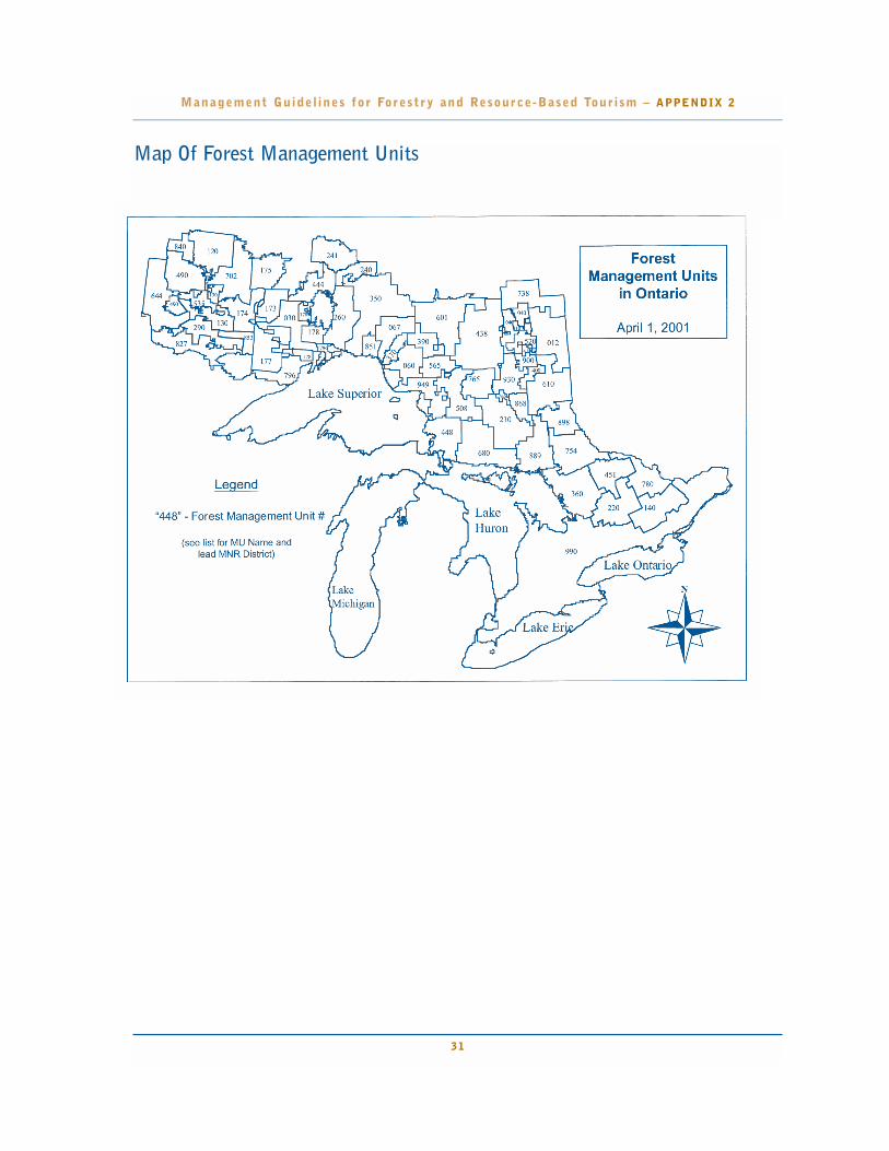
Map Of Forest Management Units
Management Guidel ines for Forestry and Resource-Based Tour ism – APPENDIX 2
31

Management Guidel ines for Forestry and Resource-Based Tour ism – APPENDIX 2
32
List of Forest Management Units in Ontario 2001/2002(designated under the Crown Forest Sustainability Act (1995), Section 7)
MU # MU Name Status Lead District Region
448 Algoma Forest SFL Sault Ste. Marie NE451 Algonquin Park Forest AFA Algonquin Park SC444 Armstrong Forest SFL Thunder Bay NW220 Bancroft-Minden Forest CR Bancroft SC067 Big Pic Forest SFL Wawa NE370 Black River Forest SFL Wawa NE178 Black Sturgeon Forest SFL Nipigon NW173 Brightsand Forest SFL Thunder Bay NW175 Caribou Forest SFL Sioux Lookout NW520 Cochrane CR Cochrane NE177 Dog River-Matawin Forest SFL Thunder Bay NW410 Driftwood Forest SFL Cochrane NE535 Dryden Forest SFL Dryden NW174 English River Forest SFL Dryden NW827 Fort Frances-Flanders Forest SFL Fort Frances NW360 French-Severn Forest SFL Parry Sound SC438 Gordon Cosens Forest SFL Hearst NE601 Hearst Forest SFL Hearst NE290 Highrock Forest SFL Fort Frances NW012 Iroquois Falls Forest SFL Cochrane NE350 Kenogami Forest SFL Nipigon NW644 Kenora CR Kenora NW651 Kiashke River Thunder Bay NW702 Lac Seul Forest SFL Sioux Lookout NW260 Lake Nipigon Forest SFL Nipigon NW796 Lakehead Forest SFL Thunder Bay NW565 Magpie Forest SFL Wawa NE140 Mazinaw-Lanark Forest CR Bancroft SC738 Moose River CR Cochrane NE390 Nagagami Forest SFL Wawa NE240 Nakina North Forest SFL Nipigon NW754 Nipissing Forest SFL North Bay NE680 Northshore Forest SFL Sault Ste. Marie NE241 Ogoki Forest SFL Nipigon NW780 Ottawa Valley Forest SFL Pembroke SC851 Pic River Ojibway Forest SFL Nipigon NW765 Pineland-Martel Forest SFL Chapleau NE840 Red Lake Forest SFL Red Lake NW930 Romeo Malette Forest SFL Timmins NE853 Sapawe Forest SFL Fort Frances NW868 Shiningtree Forest SFL Timmins NE040 Smooth Rock Falls Forest SFL Cochrane NE990 Southern Ontario various SC210 Spanish Forest SFL Sudbury NE030 Spruce River Forest SFL Thunder Bay NW889 Sudbury Forest SFL Sudbury NE508 Superior Forest SFL Chapleau NE898 Temagami CR North Bay NE610 Timiskaming Forest SFL Kirkland Lake NE900 Timmins CR Timmins NE400 Timmins Forest SFL Timmins NE120 Trout Lake Forest SFL Red Lake NW130 Wabigoon Forest SFL Dryden NW949 Wawa Forest SFL Wawa NE490 Whiskey Jack Forest SFL Kenora NW060 White River Forest SFL Wawa NE
Status: SFL - Sustainable Forest Licence; CR - Crown Managed; AFA - Algonquin Forest AuthorityNote: Forest management units in effect April 1, 2001 to March 31, 2002.
This information is subject to change. Prepared: July 11, 2001

Management Guidel ines for Forestry and Resource-Based Tour ism – APPENDIX 3
33
Issue Resolution for MappingTourism Values
Preamble
The purpose of this document is to record the under-standing reached among members of the TourismGuideline Working Group regarding the mapping oftourism values for the purpose of forest managementplanning and resource stewardship agreement (RSA)negotiations.
Both the forest and tourist industries have expressedconcerns regarding mapped information. The touristindustry has noted that they have a need to expressboth their short and long term interests in the forestand that their interests are often best expressed byidentifying "areas". The tourist industry has an ongo-ing need to have its business interests understood. Theforest industry is concerned that forest managementplanning remain the operational tool for determininghow forest operations are conducted and that forestmanagement planning not be used to make land usedecisions. The forest industry has a need to identifytourism values so that prescriptions for directing forestoperations can be developed for inclusion in forestmanagement plans.
To resolve the issue, two separate maps can be pre-pared – a Tourism Values Map and a Tourism BusinessInterest Map.
Tourism Values MapA Tourism Values Map will be maintained by MNRusing data contained in its Natural Resource ValuesInformation (NRVIS) data base in accordance withAppendix 1 - "Criteria for Mapping Values for theMinistry of Natural Resources Natural ResourceValues Information System". Noteworthy criteriainclude the following:
- Tourism establishments will be classified as "remote,semi-remote and drive-in" using definitions containedin the Ontario government approved Resource BasedTourism Policy.
- Only those identifiable features which are consideredintegral to the operation of a tourism business will be mapped.
The Tourism Values Map will be produced by MNR,based on existing information in NRVIS and in consul-tation with the Ministry of Tourism tourism advisors.
Tourism Business Interest MapA Tourism Business Interest Map is a map preparedvoluntarily by a resource based tourist operator(s)showing those parts, or all, of a forest management unitthat are important for their short and long term busi-ness interests. The map, if provided to MNR, will formpart of the supplemental documentation to a ForestManagement Plan. The forest management planningprocess will not require the production of such a map,and MNR will neither approve the map nor endorseany land use designations shown on the map.
The Tourism Business Interest Map is intended to assist inthe negotiations of an RSA(s). Where an RSA is successful-ly negotiated, the forest management planning prescrip-tions contained in the RSA will be made available for pub-lic review and comment as part of the normal forest man-agement planning (including plan amendment) process.
This direction is agreed upon and supported by the fol-lowing members of Tourism Guideline Working Group.
Original signed, Decemeber 7, 2000 by
Betty McGie
Bruce Hyer
Bud Dickson
Paul Jewiss
John McLaren
Rick Groves
Bill Thornton
Stephen Harvey
Dave Barker
Heather Barns
Paul Glassford
Gerry Webber
Sergio Buonocore

Management Guidel ines for Forestry and Resource-Based Tour ism – APPENDIX 3
34
Criteria for Mapping TourismValues for the Ministry of NaturalResources Natural Resource ValuesInformation System
Introduction
This Guide is intended to assist with the identificationof "mapable" tourism values. The purpose of settingout mapable tourism values and criteria is to supportthe Ministry of Natural Resources in its role as thecustodian of an information system for all naturalresource values. In the mapping of tourism values asdirected by this Guide the Ministry of Tourism willwork with the Ministry of Natural Resources to ensurethat mapped information is complete and accurate.This information system maintained by Ontario andreferred to as the NRVIS (Natural Resource ValuesInformation System) only deals with physical thingssuch as a lake, microwave tower, cottage or lodge. Thisinformation assists the Ministry of Natural Resourcesin a variety of planning and operational functionsincluding the development of forest managementplans. There are other things such as District LandUse Guidelines, public comments and, sophisticatedcomputer models that assist planners with the develop-ment of plans and ‘on-the-ground’ actions.
After this "Guide" has been used revisions may berequired based on operational experience withResource Stewardship Agreement negotiations andforest management planning. Ontario’s Resource-based Tourism Policy gives particular recognitionto the importance of tourism in Ontario’s forests.
Once mapped the tourism values may then beaddressed in a Resource Stewardship Agreement(RSA), in a Forest Management Plan (FMP) or, inboth. Following the preamble is a list of criteria forassessing whether or not something is a value. A list ofactual values has also been presented as a tool.Individual circumstances must be considered to deter-mine whether or not something is a value for the pur-poses of developing RSAs and FMPs.
There is a natural tendency for people involved in suchcomplex work as forest management to attempt tosimplify their planning environment. In this case it will
be attractive to leap straight to the list of tourism valueswithout first understanding the list’s significance. Thereader is cautioned; the tourism values list will neverbe complete. Also, the relatively straightforward actof defining a value does little to establish the signifi-cance or relative worth of a value; it is the businesscase supporting a value that will attend to this. The listof criteria or considerations is much more significant.The list of criteria serves as a filter for determiningwhether or not a value will be mapped.
Managing for tourism values in the forest is challeng-ing. The forest and tourist industries along with theOntario government have signed a Memorandum OfUnderstanding which should assist all parties in meet-ing this challenge. The MOU takes the first steptowards redefining the way in which two importantusers of the forest are engaged in planning their busi-ness operations. The seemingly simple act of mappingvalues is a vital aspect of the stage which is being set forthe negotiation of local agreements between the forestand tourist industries. It is the ‘map’ which will rep-resent those things that are important to thetourist industry upon which forestry prescriptionsin RSA’s will be built. The "Tourism Values" map willbe used ultimately in the development of operationalforest management prescriptions. It is important tounderstand and distinguish between the value and themeasures intended to address the value or "forestmanagement prescriptions."
This document addresses the Tourism Values Mapwhich MNR will produce in consultation with theMinistry of Tourism to support RSA negotiations. Data presented on this map will be reviewed regularlyby both the forest and tourist industries and will be subject to change.

35
Management Guidel ines for Forestry and Resource-Based Tour ism – APPENDIX 3
Generally speaking "tourism values" are natural or cul-tural resources found in the forest which are important to atourism activity or experience in which tourists participate.Ultimately it is the tourist who defines a tourism value.Values should relate, then, to the demand individuals havefor the product/experience. Ontario’s tourist industry catersto a diverse range of clients. The diversity in client baserenders the task of defining tourist values problematic. Theindustry has traditionally been classified as remote, semiremote and drive-in and depends on the availability andmaintenance of a number of important values. Remotenessand wilderness are highly valued by segments of the touristindustry. These criteria do not address remoteness andwilderness; however, this in no way diminishes their significance.
Definitions:Tourism value
For the purposes of proposing forestry prescriptions in a Resource Stewardship Agreement a tourism value isdefined as a feature on a map. Once defined on a mapand, if forest operations are planned which may affect thefeature, prescriptions are developed to protect the feature.
Criteria for mapping tourism values
1. The value must be capable of being defined spatially.
For this mapping exercise values must be tangible; some-thing that can be pointed to and touched or seen. There isa distinction between the value, the experience associatedwith a set of values and the measures taken to protect thevalue and associated experience. Both the value and associ-ated experience have value to the tourism operator andmust be considered in the development of a forest manage-ment plan or RSA. Remoteness and wilderness are impor-tant values to the tourism industry; however, they are notvalues which will be entered into NRVIS.
Ontario’s Resource-Based Tourism Policy provides defini-tion for three categories of resource-based tourism:remote, semi-remote and drive-in based on the level ofexisting access.
2. The mapped information must be accurate
Decisions which consider the information can result insignificant costs or losses to business.
3. The information must be verifiable
Decisions made and the actions taken as a result of thesedecisions will form part of a forest management plan.Forest management plans are legal documents, subject toaudit and periodic review.
4. The information must be timely
Not all information may be readily available. When infor-mation gaps are apparent efforts should be made to gathersufficient information to consider the value effectively inan RSA and forest management plan. While some delaymay be inevitable, extraordinary delays can upset theapproval of a forest management plan which in turn maylead to significant business losses. Information should beprovided in a timely fashion and addressing the gaps ininformation should be part of good business planning bythe tourism business operator.
5. The value must be related to the operation of atourism business
When seeking verification of a tourism value the touristbusiness operator may be required to demonstrate howthe value contributes to the tourism business.Documentation related to the value’s contribution to atourism business may be contained in a business plan,marketing and promotional material or capital investmentrelated to the value. There may be a need to ensure theconfidentiality of this information and this can certainly beaccommodated; however, the value itself will become pub-lic knowledge. Additional characteristics of the value andits use may assist with planning for the value including fre-quency of use, type of use, time of use and season of use.If the value is a recurring phenomena it may be prudent tostate how common the value is (i.e. beaver pond vs. thehighest hill in Ontario).
6. The value must be expressed in terms readilyunderstood by both industries and the Ontariogovernment
Forest management is complicated; for ease of expressionand to facilitate communication among forest manage-ment planners lingo and jargon are in common use. Everyeffort should be made to ensure that the description of atourism value is expressed in common every-day language.Attention to this will reduce the potential for misunderstandings.

Management Guidel ines for Forestry and Resource-Based Tour ism – APPENDIX 3
7. Lake edge or high water mark is an important ref-erence point in the establishment of measures for pro-tecting tourism values. The high water mark is a geo-detic reference from which tree cover may be meas-ured. While vegetative cover around lakes may addresswater quality concerns standing trees of a certain heightand density may be required to address tourism inter-ests associated with water bodies; measuring the dis-tance of standing tree cover from the high water markmay be useful in delineating forestry prescriptions.
8. A forest value requiring special consideration as atourism value is a value which does not receive consideration in any of the other ‘guidelines.’
There are many "guidelines" which forest managers mustconsider when developing a forest management plan. Insome cases the values addressed in the "guideline" are impor-tant to tourism; however, their primary importance is as acomponent of the forest system or as part of the cultural fab-ric of the forest. The value placed on these by the touristindustry may not require any specific action to be taken. If,however, through the tourist industry’s use of a value, addi-tional consideration must be given to that value then thevalue becomes a "tourism value." This is perhaps bestexplained by example. Moose aquatic feeding areas areaddressed by the Timber Management Guidelines for theProvision of Moose Habitat. If a tourism business mar-kets a specific moose aquatic feeding area as a "moose view-ing area," a trail to the area is developed and viewing sta-tion established, then there may be special needs above andbeyond the provision of habitat which forest managers shouldconsider; the moose aquatic viewing area then becomes atourism value. If on the other hand, the tourist businessbrochure simply states that there are abundant opportunitiesfor seeing moose in the area of a lodge then moose aquaticfeeding areas have no additional significance attached tothem and they should not be defined as a "tourism value."
9. Every tourism value map must be in the supportof one or more of the following resource basedtourism interests as stated in the Tourism andForestry Industry Memorandum of Understanding
• Natural aesthetics
• Remoteness, including maintenance of traditionalmeans of access
• Maintenance of the perception of wilderness,
• Sustainability and enhancement of fish, game and wilder-ness opportunities necessary for tourism operations
• Maintenance of the perception of Ontario as aworld class wilderness tourism destination
List of Tourism Values
It is not intended that prescriptions be developed ineach forest management plan for each value listed;rather, only those values identified locally and under-stood to be important to the tourist industry will havespecial measures taken to protect them.
TOURISM ESTABLISHMENTS
All establishments will be classified according to remote,semi remote, drive-in according to the definitions con-tained in Ontario’s Resource-based Tourism Policy.
4. Remote tourism - a tourism resource, opportunity,value of potential development that is not accessibleby road and is based on a remote wilderness experi-ence where access is only gained through air, wateror rail. The important attributes of this productinclude inaccessibility, isolation from visual and audi-tory impacts, and high quality environmentalresources (e.g. fish and wildlife).
5. Semi-remote tourism - similar to a remotetourism opportunity except that road access is limit-ed and may be controlled through artificial means orthe use may be limited to protect the resources,opportunity or value. The non-traditional means ofaccess include: restricted road, ATV trail, marine6,and portage.7 The same attributes that are importantto remote tourism are important here as well, exceptas how they are changed by the lesser amount ofremoteness.
6. Drive-in resource-based tourism - includes unencumbered road access in regards to the use ofthe tourism resource. Important characteristics ofthis resource include full accessibility, compositeuse8, maintenance of both the visual and auditoryenvironmental setting9 and access to good qualityresources.10
6 Marine refers to traditional waterway access.
7 Portage refers to canoe routes.
8 Composite use refers to two or more compatible uses co-existing in proximity to one another.
9 Refers to the protection of skyline areas of concern and man-made noise abatement.
10 Refers to the importance of having access to ecologically sustainableland.
36

37
Management Guidel ines for Forestry and Resource-Based Tour ism – APPENDIX 3
Main Base Lodges
Description: fixed roof accommodation, has a currentResource-based Tourism Licence and commercial landuse permit or other form of property tenure. TheTourism Act defines a "base of operations" as ‘a licensetourist establishment or an air carrier licensed under thelaws of Canada from which a tourist outfitter maintainsfacilities for communication, transportation and the completemaintenance of office records.’
Outpost Camp
Description: fixed roof accommodation, has a currentResource-based Tourism Licence and commercial landuse permit or other form of property tenure. TheTourism Act defines an outpost camp as any fixed or portable rental unit that is remote from a base ofoperations and accessible only by air, water or foresttrails, and is used for commercial purposes.
ROADS & TRAILS
Recreation Trails
• Description: Winter (dog sled trails, cross country trails,snowshoe trails, snowmobile trails, etc.)
• Summer (ATV trails, horse trails, portage trails, etc.)
• All Season (hiking trails, hunting trails, etc.)
Access: Description: road, flight path, water route or rail lineproviding access to a tourism business or associated value. It isrecognized that entire flight paths cannot be addressed; rather,only segments which can be reasonably associated with atourism experience should be considered a value. Usually it isthe final approach portion of a flight path which is a concern.
Tourism Access Points: Description: landing, access towater body, access to railroad or other modes of transporta-tion specifically used to access a tourism establishment.
ANCILLARY FEATURES
Shore Lunch & Picnic Sites
Description: includes shore lunch site, etc.
Viewpoint
Description: point for viewing prominent scenery or vista, etc.
Camping Sites
Description: Type "B" Outpost Camp (i.e. Mini LUP) (e.g.moose camps, bear camps, etc.)
Boat Caches
Description: the site where boats are cached according to anMNR permit (applicable in Northwestern Ontario.)
Canoe Routes
Description: route actively marketed for use by guestsof Ministry of Tourism licensed resource-basedtourism establishments.
Navigable Channel
Description: Generally a narrow channel connecting twowater bodies used by guests of a tourism establishment
WATER-RELATED FEATURES
Swimming Beach
Description: Not a public beach, but, a beach to which guestsfrom a tourism establishment are directed.
WILDLIFE-RELATED FEATURES
Fish and Wildlife Viewing Site
Description: that part of the forest that is especiallyimportant for viewing of wildlife including mooseviewing area, bird feeder area, deer viewing area.
Wildlife Hunting Stations
Description: duck blinds, bear baiting areas, deer stands etc.
CULTURAL/HERITAGE-RELATED FEATURES
Cultural Heritage sites
Description: An old building, mine archaeological site,interpretive site, historical site or other cultural featurewhich because of its use by a tourist establishmentrequires more protection than that afforded by the"Cultural Heritage Guidelines."

51544(2.5kP.R., 19 07 01)ISBN 0-7794-1568-X
Printed on recycled paper