Management Act; and reconciling avoidance, mitigation, and risk
16
Saunders, W.S.A, Beban, J.G, & M Kilvington, 2013. Risk-based approach to land use planning. GNS Science, www.gns.cri.nz/risk-based-planning LEGISLATIVE FRAMEWORK FOR NATURAL HAZARDS The following discussion is provided based on the legislative environment at the time of publication (August 2013). As legislation is expected to change in regards to hazard management towards the end of 2013 (i.e. Resource Management Act reforms), this section will be updated to reflect any changes. The following discussion is an updated version of that provided in Saunders & Beban (2012). It includes an overview of the current legislative framework; definitions of natural hazards within legislation; roles and responsibilities; the New Zealand Coastal Policy Statement; risk reduction and the Civil Defence Emergency Management Act; and reconciling avoidance, mitigation, and risk reduction under the Resource Management Act. 1. CURRENT LEGISLATIVE FRAMEWORK In New Zealand, no one agency is responsible for natural hazard management. Rather, a number of organisations including the Ministry of Civil Defence Emergency Management (MCDEM), regional councils, territorial authorities, civil defence emergency management groups, and engineering lifeline groups hold these responsibilities (MfE, 2008). Co-operation between these agencies is essential to ensure a streamlined and holistic national approach to planning for disasters. There are four key pieces of legislation that have a primary influence on natural hazard management in New Zealand: the RMA, Building Act 2004, Civil Defence Emergency Management Act 2002 (CDEMA), and Local Government Act 2002 (LGA). The four key statutes are intended to be integrated in their purposes, which all promote sustainability, as shown in Table 1. Other statutes also contribute to natural hazard management, to a lesser degree. These include the Local Government Official Information and Meetings Act 1987 (LGOIMA), by allowing hazard information to be available for all parcels of land, through a Land Information Memorandum (LIM); Environment Act 1986; Conservation Act 1987; Soil Conservation and Rivers Control Act 1941; Land Drainage Act 1908; and the Forest and Rural Fires Act 1977 (see Tonkin & Taylor, 2006, for further information). Apart from the LGA, the purposes of the statutes in Table 1 are consistent in that they have a focus on sustainable management or development, and refer to the social, economic and cultural well-beings, as well as health and safety. However, while sustainable management is defined under the RMA, it is not defined in the CDEMA; sustainable development is also not defined in the Building Act or LGA. Also, balancing of the four well-beings is not required; rather, economic considerations can take priority over social, environmental and cultural well- beings. This priority reflects the political prerogative to encourage market solutions to the management of natural and physical resources (Ericksen, Berke, Crawford, & Dixon, 2003). Given this non alignment between the various pieces of legislation with the definition of sustainable management, the following section outlines the definitions of natural hazards within these statutes.
Transcript of Management Act; and reconciling avoidance, mitigation, and risk

Saunders, W.S.A, Beban, J.G, & M Kilvington, 2013. Risk-based approach to land use planning. GNS
Science, www.gns.cri.nz/risk-based-planning
LEGISLATIVE FRAMEWORK FOR NATURAL HAZARDS
The following discussion is provided based on the legislative environment at the time of publication (August 2013). As legislation is expected to change in regards to hazard management towards the end of 2013 (i.e. Resource Management Act reforms), this section will be updated to reflect any changes. The following discussion is an updated version of that provided in Saunders & Beban (2012). It includes an overview of the current legislative framework; definitions of natural hazards within legislation; roles and responsibilities; the New Zealand Coastal Policy Statement; risk reduction and the Civil Defence Emergency
Management Act; and reconciling avoidance, mitigation, and risk reduction under the Resource Management Act.
1. CURRENT LEGISLATIVE FRAMEWORK
In New Zealand, no one agency is responsible for natural hazard management. Rather, a
number of organisations including the Ministry of Civil Defence Emergency Management
(MCDEM), regional councils, territorial authorities, civil defence emergency management
groups, and engineering lifeline groups hold these responsibilities (MfE, 2008). Co-operation
between these agencies is essential to ensure a streamlined and holistic national approach to
planning for disasters.
There are four key pieces of legislation that have a primary influence on natural hazard
management in New Zealand: the RMA, Building Act 2004, Civil Defence Emergency
Management Act 2002 (CDEMA), and Local Government Act 2002 (LGA). The four key
statutes are intended to be integrated in their purposes, which all promote sustainability, as
shown in Table 1. Other statutes also contribute to natural hazard management, to a lesser
degree. These include the Local Government Official Information and Meetings Act 1987
(LGOIMA), by allowing hazard information to be available for all parcels of land, through a
Land Information Memorandum (LIM); Environment Act 1986; Conservation Act 1987; Soil
Conservation and Rivers Control Act 1941; Land Drainage Act 1908; and the Forest and Rural
Fires Act 1977 (see Tonkin & Taylor, 2006, for further information).
Apart from the LGA, the purposes of the statutes in Table 1 are consistent in that they have a
focus on sustainable management or development, and refer to the social, economic and
cultural well-beings, as well as health and safety. However, while sustainable management is
defined under the RMA, it is not defined in the CDEMA; sustainable development is also not
defined in the Building Act or LGA. Also, balancing of the four well-beings is not required;
rather, economic considerations can take priority over social, environmental and cultural well-
beings. This priority reflects the political prerogative to encourage market solutions to the
management of natural and physical resources (Ericksen, Berke, Crawford, & Dixon, 2003).
Given this non alignment between the various pieces of legislation with the definition of
sustainable management, the following section outlines the definitions of natural hazards
within these statutes.

Saunders, W.S.A, Beban, J.G, & M Kilvington, 2013. Risk-based approach to land use planning. GNS
Science, www.gns.cri.nz/risk-based-planning
Table 1 Purposes of key legislation for the management of natural hazards (emphasis added).
Statute Purpose
Resource
Management Act
1991 (Part 2,
Section 5)
To promote the sustainable management of natural and physical resources.
Sustainable management means managing the use, development, and
protection of natural and physical resources in a way, or at a rate, which
enables people and communities to provide for their social, economic, and
cultural wellbeing and for their health and safety.
Building Act 2004
(Part 1, Section 3)
To provide for the regulation of building work, the establishment of a licensing
regime for building practitioners, and the setting of performance standards for
buildings, to ensure that—
(a) people who use buildings can do so safely and without endangering their
health; and (b) buildings have attributes that contribute appropriately to
the health, physical independence, and well-being of the people who use
them; and
(c) people who use a building can escape from the building if it is on fire; and
(d) buildings are designed, constructed, and able to be used in ways that
promote sustainable development.
CDEM Act 2002
(Part 1, Section 3)
To improve and promote the sustainable management of hazards in a way that
contributes to the social, economic, cultural, and environmental well-being and
safety of the public and also to the protection of property
Local Government
Act 2002 (Part 1,
Section 3)
To provide for democratic and effective local government that recognises the
diversity of New Zealand communities
2. DEFINITIONS OF NATURAL HAZARDS
While the purposes of the four statutes are intended to be integrated and consistent, the
definitions of natural hazards vary. While the LGA does not define natural hazards, they are
defined under the RMA, Building Act and CDEMA, as shown in Table 2.
While the Building Act is limited to certain phenomena, the RMA and CDEMA have unlimited
definitions, both of which are consequence driven (i.e. may adversely affect human life,
property; may cause or contribute to an emergency). This allows for consequences (and
associated vulnerabilities, susceptibilities etc.) to be assessed. The implication of this
difference in approach with defining natural hazards is often not fully appreciated by land use
planners, building officers, or emergency management officers, and can lead to inappropriate
decisions being made. It is therefore important that the linkages between the statutes is
understood and integrated between roles (planners, emergency management officers,

Saunders, W.S.A, Beban, J.G, & M Kilvington, 2013. Risk-based approach to land use planning. GNS
Science, www.gns.cri.nz/risk-based-planning
building officers etc.). The following section outlines these linkages, roles and responsibilities.

Saunders, W.S.A, Beban, J.G, & M Kilvington, 2013. Risk-based approach to land use planning. GNS
Science, www.gns.cri.nz/risk-based-planning
Table 2 Legislative definitions of natural hazards
Statute Definition of natural hazard Comment
Resource
Management
Act 1991
Any atmospheric or earth or water
related occurrence (including
earthquake, tsunami, erosion,
volcanic and geothermal activity,
landslip, subsidence,
sedimentation, wind, drought, fire,
or flooding) the action of which
adversely affects or may adversely
affect human life, property, or other
aspects of the environment.
Under Section 106, a consent authority may
refuse to grant a subdivision consent, or may
grant a subdivision consent with conditions, if
it considers that the land, and any
subsequent use of the land or any structure
is or is likely to accelerate, worsen, or result
in material damage to the land, other land, or
structure by erosion, falling debris,
subsidence, slippage, or inundation from any
source. This section does not include
consequences from active faults, tsunami, or
geothermal activity, and is inconsistent with
the definition of a natural hazard.
Building Act
2004
Erosion (including coastal erosion,
bank erosion, and sheet erosion);
falling debris (including soil, rock,
snow, and ice); subsidence;
inundation (including flooding,
overland flow, storm surge, tidal
effects, and ponding); and slippage.
Definition does not include active faults,
liquefaction, lateral spreading, or tsunami.
CDEM Act
2002
Something that may cause, or
contribute substantially to the cause
of, an emergency.
Includes all natural and anthropogenic
hazards.
3. INTEGRATED ROLES AND RESPONSIBILITIES
The integration of the practice of hazard management can be improved by understanding how
the various roles and responsibilities of central government agencies, regional councils,
territorial authorities, and non-statutory planning tools can work together to provide a holistic
approach. Figure 1 shows these relationships, and areas for improvement.
Figure 1 presents the five main statutes that govern natural hazards planning at different
levels of government, namely central (orange), regional (green) and district/city (blue) levels.
The hierarchy of plans established under each statute provides various regulatory and
non-regulatory tools for natural hazards planning. The solid arrows show established
relationships in the hierarchy of provisions. The dashed arrows highlight relationships
between existing provisions where there is an opportunity for strengthening linkages. The
relationships may be one- or two-way. These legislative provisions and the array of tools they
provide constitute a robust ‗toolkit‘ for natural hazards planning. However, many of these tools
are not well known amongst either planners or emergency management officers, nor used to
their full potential to reduce hazard risk and build community resilience (Glavovic, Saunders, &
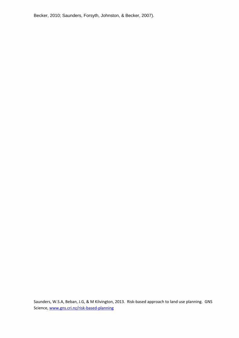
Saunders, W.S.A, Beban, J.G, & M Kilvington, 2013. Risk-based approach to land use planning. GNS
Science, www.gns.cri.nz/risk-based-planning
Becker, 2010; Saunders, Forsyth, Johnston, & Becker, 2007).
Saunders, W.S.A, Beban, J.G, & M Kilvington, 2013. Risk-based approach to land use planning. GNS Science, www.gns.cri.nz/risk-based-planning
Figure 1 Legislative roles and responsibilities for hazard management in New Zealand (adapted from Saunders, et al., 2007).
2
2
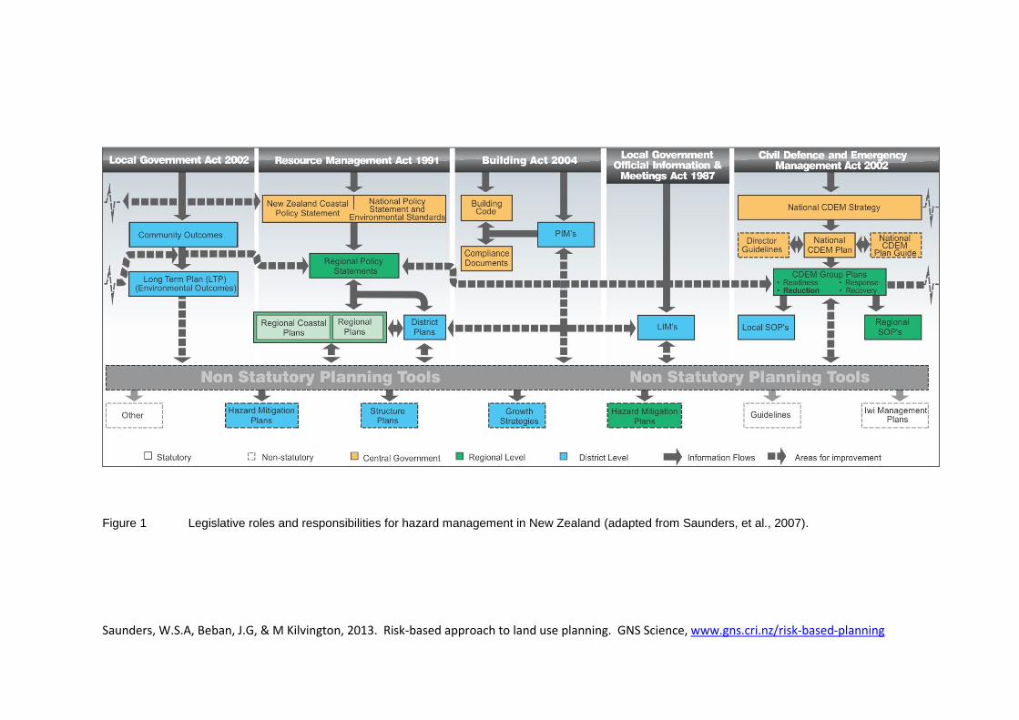
Under LGOIMA, territorial authorities must issue a LIM on request. The LIM provides
information that a council holds on a parcel of land, including natural hazards. LIMs allow
the applicant to become aware of any natural hazard on which a council holds information
that may affect their property, and enables them to assess their willingness to accept or
tolerate that risk. However, if hazard information is included in the district plan, it is not
required to be included in the LIM. It is questionable whether applicants for LIMs are aware
that the LIM may not include all information held by a council for a site, if that information is
held in the district plan. Many LIM applicants assume that the LIM will contain all hazard
information available.
Table 3 provides a summary of how these statutes contribute to the management of natural
hazards in New Zealand. It can be seen from the table that primarily the reduction of risk
lies with the RMA, whereas emergency management (readiness, response, recovery) lies
with the CDEMA.
Table 3 Summary of ways in which statutes contribute to the management of natural hazards
Statute Implication for natural hazard management
Resource
Management Act
1991
Health and safety issue must be addressed
Local authorities are required to avoid or mitigate the effects of natural hazards, not their occurrence (Canterbury RC v Banks Peninsula DC, 1995).
NZCPS includes specific coastal hazard policies.
S106 (consent authority may refuse to grant subdivision consent) does not allow for the consideration of all natural hazards as defined.
The ability to develop national policy statements and national environmental standards to address natural hazards (none currently exist).
Building Act 2004 Requires all buildings to be ‗safe from all reasonably foreseeable actions
during the life of the building‘.
Reference is made to the joint Australian/New Zealand loading standard AS/NZS1170 (Standards Australia/New Zealand, 2002), where the acceptable annual probability of exceedence for wind and earthquake loads are identified. These relate to the return period for an event (being 1/500, 1/1000 and 1/2500) and the building importance categories of II (Ordinary) III (Important) and IV (Critical). The more important the building, the longer the return period of an event is the structure required to be designed for.
These annual probabilities of exceedence correspond to a 10%, 5% and 2% probability within the nominal 50 year life of the building.
The ability to resist actions from other hazards is specified in the Building Code (a regulation that accompanies the Building Act) but no acceptable intensity of action or recurrence interval is prescribed either in the Code or in the Loading Standard (except for snow which has a nominal annual probability of exceedence of 1/150 years).
Sections 72 – 74 of the Building Act identify the process that Councils must follow when considering a building consent on a site subject to 1 or more natural hazards. The Building Act allows for Council to decline a building consent if, by granting the consent, the development would worsen or
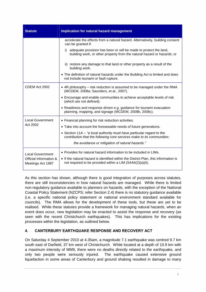
3
3
Statute Implication for natural hazard management
accelerate the effects from a natural hazard. Alternatively, building consent can be granted if:
i) adequate provision has been or will be made to protect the land, building work, or other property from the natural hazard or hazards; or
ii) restore any damage to that land or other property as a result of the building work.
The definition of natural hazards under the Building Act is limited and does not include tsunami or fault rupture.
CDEM Act 2002 4R philosophy – risk reduction is assumed to be managed under the RMA (MCDEM, 2008a; Saunders, et al., 2007).
Encourage and enable communities to achieve acceptable levels of risk (which are not defined).
Readiness and response driven e.g. guidance for tsunami evacuation planning, mapping, and signage (MCDEM, 2008b, 2008c).
Local Government
Act 2002
Financial planning for risk reduction activities.
Take into account the foreseeable needs of future generations.
Section 11A – “a local authority must have particular regard to the contribution that the following core services make to its communities:
the avoidance or mitigation of natural hazards.”
Local Government
Official Information &
Meetings Act 1987
Provides for natural hazard information to be included in LIMs.
If the natural hazard is identified within the District Plan, this information is not required to be provided within a LIM (S44A(2)(a)(ii).
As this section has shown, although there is good integration of purposes across statutes,
there are still inconsistencies in how natural hazards are managed. While there is limited
non-regulatory guidance available to planners on hazards, with the exception of the National
Coastal Policy Statement (NZCPS; refer Section 2.4) there is no statutory guidance available
(i.e. a specific national policy statement or national environment standard available for
councils). The RMA allows for the development of these tools, but these are yet to be
realised. While these statutes provide a framework for managing natural hazards, when an
event does occur, new legislation may be enacted to assist the response and recovery (as
seen with the recent Christchurch earthquakes). This has implications for the existing
processes within the legislation, as outlined below.
4. CANTERBURY EARTHQUAKE RESPONSE AND RECOVERY ACT
On Saturday 4 September 2010 at 4.35am, a magnitude 7.1 earthquake was centred 9.7 km
south east of Darfield, 37 km west of Christchurch. While located at a depth of 10.9 km with
a maximum intensity of MM9, there were no deaths directly related to the earthquake, and
only two people were seriously injured. The earthquake caused extensive ground
liquefaction in some areas of Canterbury and ground shaking resulted in damage to many

4
4
commercial and residential buildings, which were unable to be reinstated.
The implication of the event from a legislative perspective was the enactment of the
Canterbury Earthquake Response and Recovery Act 2010, which was passed under
urgency on 14 September 2010. The legislation enabled the relaxation or suspension of
statutory requirements, until 1 April 2012, that have the potential to divert resources away
from the recovery efforts; may be unable to be complied with as a result of the earthquake;
or could delay a prompt response to the emergency recovery. This exemption applied to all
legislation that may be affected during the response and recovery, including the Building Act,
CDEMA, RMA, LGA and LGOIMA. Many orders refer to removing liability for certain actions,
extension of legislative timeframes, and the amount of information provided in LIMs (refer to
Wynn Williams & Co, 2011 for further details of orders). The legislation also created the
Earthquake Recovery Commission to provide advice and guidance, but the commission
holds no liability for decisions being made.
On 22 February 2011 a shallow, magnitude 6.3 aftershock occurred under the Port Hills of
Christchurch. This caused devastating damage to the CBD and the greater Christchurch
area, with 185 confirmed deaths and hundreds of injuries. The event resulted in the first
national declaration of an emergency in New Zealand. This earthquake resulted in further
changes via Orders in Council under the Canterbury Earthquake Response and Recovery
Act 2010, and the legislative establishment of the Canterbury Earthquake Response Agency
(CERA) in April 2011. Changes under Orders in Council included the streamlining and
fast tracking of resource consents for land remediation works. It was considered that the
normal process of public notification, hearings and appeals would delay the rebuilding of
suburbs, potentially for years. Under this Order, affected parties have two weeks to provide
written submissions prior to councils making a decision (NZPI, 2011). It is too soon to
understand or assess the process that CERA will implement. However, these new statutes
show how the management of natural hazards is often reactive, in that the legislative
environment can change in response to an event. Consideration of improving risk reduction
via land-use planning provides a proactive, rather than reactive, response to natural hazards
and ensures the sustainability of communities is not compromised.
5. NEW ZEALAND COASTAL POLICY STATEMENT
The 2010 NZCPS (Department of Conservation, 2010) is the only national regulatory policy
document that provides guidance on the management of coastal hazards. Regional policy
statements, regional plans and district plans must give effect to the NZCPS. The NZCPS
specifically includes natural hazards in Policies 24 (Identification of coastal hazards) and 25
(Subdivision, use and development in areas of coastal hazard risk). In particular, Policy 25
states:
… in areas potentially affected by coastal hazard over at least the next 100 years:
(a) avoid increasing the risk of social, environmental and economic harm from
coastal hazards; (b) avoid redevelopment, or change in land use, that would
increase the risk of adverse effects from coastal hazards;… (f) consider the
potential effects of tsunami and how to avoid or mitigate them.
Policy 24 refers to ―areas at high risk‖, but this risk level is not defined, i.e. factors that
determine high or low risk are not provided.
5
5
6. RISK REDUCTION AND THE CDEMA
Saunders et al. (2007) provide details on how risk reduction requirements under the CDEMA
are assumed to be managed under the RMA Act, via regional policy statements and district
plans (refer Appendix 1). In summary, it is essential that consistent policies between CDEM
group plans and RMA plans are provided, to ensure that risk reduction is effective in
achieving common risk reduction objectives and outcomes, particularly around land use
recovery (Becker, Saunders, Hopkins, Wright, & Kerr, 2008).
The term risk reduction is not included in the RMA, only the requirement to avoid or mitigate
natural hazards (see next section). This requires emergency management officers and land
use planners to work together with their communities to ascertain levels of risk (as required
under the National CDEM Strategy (MCDEM, 2008a)), which are otherwise not defined.
RMA decision makers and planners are therefore primarily responsible for risk reduction
(Saunders, et al., 2007) and land use decisions – although there is often resistance to
managing natural hazards due to costs of undertaking risk assessments and the potential for
litigation. In order to achieve sustainable risk reduction, it is imperative that these two
professions work together (for further information refer to webpage
http://www.em.gov.au/Documents/AJEM_Feb07_StrengtheningLinkages.pdf). Under the
RMA, the primary focus is on avoiding, remedying or mitigating the effects of natural
hazards. This is the focus of the following section.
7. RECONCILING AVOIDANCE, MITIGATION, AND RISK REDUCTION UNDER THE RMA
Within the RMA, the definition of sustainable management includes avoiding, remedying, or
mitigating any adverse effects of activities on the environment, with no preference given for
any option, or any reference to risk. Contrary to international definitions of mitigation that
include avoidance (Burby, 1998; Godschalk, 2002; Mileti, 1999), in New Zealand the term
mitigation is typically used to include measures other than avoidance, as that is a separate
option. In the CDEMA, neither risk reduction nor mitigation is defined. In the National
CDEM Strategy, risk reduction is a combination of avoidance and mitigation (MCDEM,
2008a).
The terms ‗avoid, remedy and mitigate‘ are not defined within Section 2 of the RMA and
there is limited case law to provide guidance on how these concepts can be applied to
natural hazards. In practice, greater emphasis is given to avoiding and mitigating the risks
associated with hazards than remedying the effects. This is reinforced in Sections 30 and 31
(functions of regional councils and territorial authorities) where regional councils and
territorial authorities are only required to avoid and mitigate natural hazards when controlling
the use of the land and the effects of an activity. The common meaning of ‗remedy‘ is ―a
means of counteracting or eliminating something undesirable‖
(http://oxforddictionaries.com/definition/english/remedy). In the case of most natural hazards
(e.g. landslides, tsunami, flood, earthquake), the hazard cannot necessarily be eliminated
and therefore remedying it becomes impractical. Rather, avoidance or mitigation measures
can lessen the risk to people and property and are therefore given greater emphasis (Burby,
1998; Ericksen, 1986; Mileti, 1999; Saunders & Glassey, 2007).
However, there are subtle differences in outcomes between avoidance and mitigation under
6
6
the RMA, and risk reduction under the CDEMA. Mitigation can be defined as an element of
risk reduction, involving an action taken to reduce or eliminate long-term risk to people and
property from hazards and their effects (excluding avoidance)1 (Godschalk, 2002). Under
the National CDEM Strategy, risk reduction is defined as:
Identifying and analysing long-term risks to human life and property from hazards;
taking steps to eliminate these risks if practicable, and, if not, reducing the
magnitude of their impact and the likelihood of their occurring‖ (MCDEM, 2008a,
p5).
It is assumed that this definition includes avoidance via ‗taking steps to eliminate these risks‘
– of which avoidance is an option. While avoidance is an option separate from mitigation in
the RMA, risk reduction under the CDEMA includes both mitigation and avoidance. Levels
of risk are often cited when mitigation and risk reduction are discussed (e.g. NZCPS Policy
25(a); CDEMA s3(b)). However, there is little guidance available on what an acceptable
level of risk is, to whom, and to what. This has implications for planning policy, when
acceptable levels of risk are included in policy, but not defined.
In the New Zealand context, avoidance achieves risk reduction by not putting people and
property in harm‘s way. In contrast, mitigation provides measures that incorporate the risk,
but may still leave people and property at risk (i.e. residual risks, which may require
structural protective works), and therefore may not achieve risk reduction. Two Environment
Court examples highlight the implications of this discrepancy: Kaihikatea Estate in the
Coromandel, and the Holt case in Dunedin – both of which focus on acceptable levels of risk
and mitigation measures. Kaihikatea Estate provides an example of the implications of
mitigation, in that it does not require mitigation to be effective, only applied. This example is
provided in Appendix 1.
1 Note that this definition of mitigation is based within the US context, which includes avoidance. However, for
the purposes of this research, and as no definition of mitigation is provided under the RMA, it can be applied
to New Zealand acknowledging that avoidance is a separate option.
7
7
APPENDIX 1 KAIHIKATEA ESTATE DEVELOPMENT
An example of how mitigation can be interpreted and implemented is the Kahikatea Estate
subdivision application in the Thames-Coromandel District. The application provides one
example where mitigation measures have been put in place, but risk to property (and
personal safety, depending on the effectiveness of emergency management plans) is
increased. This example also highlights how risk governance is dependent on institutional
arrangements – in this case, the legal framework of the RMA.
Located on the Tairua River floodplain, the site is tidally influenced and had been flooded
from the river five times during the previous 12 years. As such, the site is expected to flood
on average every two to five years (Tonkin & Taylor, 2005). The site is deemed a high
hazard site by the regional council, as the depth of flow in the main floodway is greater than
one metre and/or speed of flow is greater than one metre per second. Rather than avoiding
the risk altogether, this hazard was addressed by the applicants with mitigation options, their
philosophy being to ―recognise the risk of flooding that exists and to take measures to
overcome the hazard risks, without endeavouring to impede the natural flow patterns of
floodwater through the site‖ (Bhana, 2005, p7).
Original mitigation options proposed by the applicants included (Bhana, 2005, p7-8):
A pontoon jet-drive rescue craft being permanently maintained on site. Carrying up to
nine people, the craft would be used to evacuate people from their homes from
designated loading and unloading areas. Several people in the area would be trained to
operate the rescue craft on a first-response basis.
Automated early warning systems to monitor river and rainfall levels, to provide
adequate warning to evacuate if required. This system is also linked to the first
response [emergency management] network.
Safe areas will be provided above the flood levels where cars could be stationed in
the event of rising water levels, with all-weather access to the main road. Alarms
would give ample time for vehicles to be taken to the designated area. Community
facilities would be above any flood levels, and would provide shelter for the residents
if required as well as a command post for a first-response team.
Also identified in the consultant report (Tonkin & Taylor, 2005, p18) was that:
Potential damage to buildings and building platforms will be mitigated by setting
minimum floor levels to EW [Environment Waikato2] standards and constructing
platform batters and building foundations to withstand flood velocities. In a similar
way, the potential for loss of life and/or injury may be mitigated by proper planning
and procedures.
The upstream corners of the building platforms were also to be reinforced (Arcus, 2006). It
was summarised in the consultant report (Tonkin & Taylor, 2005, p20) that: ―The risk of
developing within the floodplain is accepted by the developer …‖. This raises issues of who
is accepting the risks – the developer in the short term, but future purchasers in the long
term. The Regional Council stated in their planner‘s report that:
2 EW changed its name in April 2011 to Waikato Regional Council (WRC).
8
8
…the current location of the building platforms or sites for residential development
proximity to the Tairua River based a [sic] precautionary approach to represent too
great a risk to be suitable for residential development (cited in TCDC, 2006, p23).
The application was publicly notified, and subsequently an independent commissioner was
appointed. In June 2006 the Commissioner approved the application, subject to conditions
of consent being imposed (including the provision of a rescue boat). In his conclusion, the
Commissioner stated that ―Material damage to structures is unlikely because the structures
are above a very conservative minimum floor level‖ and ―Occupants are unlikely to be at risk
because of the warning system. In the unlikely event that it fails there are other factors which
would alert occupants to flood‖ (Arcus, 2006, p31).
In May 2008 the Environment Court issued a consent notice which included the following
conditions (Judge Dwyer, 2008, p3-4):
3. The consent holder shall provide a detailed Emergency / Hazard Management Plan ‗E/HMP‘, detailing the provisions to be made to ensure the safety of occupants of the subdivided lots in the event of inundation of the site. This shall be submitted for the approval of the Thames-Coromandel District Council‘s Monitoring Officer. The E/HMP shall include but not be limited to the following measures:
a) Ensuring the installation and ongoing maintenance of a new river level recorder.
b) Ensuring an existing river gauge (Broken Hill) is upgraded to provide secure and ongoing river level data.
c) The installation and ongoing maintenance of a 24 hour a day river level monitoring system shall be connected to all residential buildings and the Regional Council.
d) Ensuring the provision of an evacuation plan. This is to be developed and maintained by the Residents Association of Kahikatea Estate, and will be developed around different responses corresponding to onsite water levels.
e) Ensuring members of the residents association receive as minimum annual training in compliance with the provisions of the E/HMP.
f) Ensuring the culverts under the internal driveway are regularly maintained including at least annually the
I. Clearance of any accumulated debris, and
II. Rectifying any visible signs of erosion.
g) Ensuring any maintenance to the internal private way results in the RL of the private way being retained at the Hauraki Catchment BD Datum level of 14.5 metres with variance of 0.02 metres.
h) Ensuring the ongoing maintenance of the building platforms for flood defence purposes for each of the residential lots.
i) Ensuring the area defined as ‗Restricted Planting Area‘ is managed so its primary purpose as a floodway is not compromised.
4. The consent holder shall provide to the Thames-Coromandel District Council a copy of the documentation establishing the Residents Association and setting out to the satisfaction of the
9
9
Council‘s Monitoring Officer the responsibilities of the Association in terms of on-going site management. This includes arrangements to ensure compliance of the E/HMP; and providing Council with an annual report demonstrating on-going compliance. This is to be prepared by an independent certifier appointed by the Association and acceptable to the Council‘s Monitoring Officer.
The original jet boat response measure was not included in the final decision. This case
provides an example of the wider implications for risk reduction, including the importance of
qualifying and/or quantifying the levels of risk for natural hazards to ascertain and clarify
what is acceptable, tolerable and intolerable; who accepts the short- and long-term risks i.e.
the developer versus a future purchaser; and the paradoxical relationship between mitigation
and risk reduction (i.e. mitigation does not necessarily result in a reduction of risk). In this
case, risks to property are still potentially problematic for those dwelling in these properties.
While the developer was willing to accept the risk, future owners/generations will have a
legacy of flood risk to live with if they choose to (see also Handmer (2008)). The mitigation
measures proposed lead to an increase in risk from the original land use, otherwise the
consent conditions would not be required. To date, the development has not yet begun due
to the 2009-10 economic recession.
The decision highlighted the inadequacy of the existing district plan provisions for managing
flood risks. As a result of this decision, the Thames-Coromandel District Council undertook
a plan change to the flooding section of the district plan‘s natural hazard chapter, which is
yet to become operative. Ironically, the website for the development states that:
Sites will have a high standard of amenities including a gravelled driveway to
improve water dispersal … The development exceeds local body resource consent
standards, preventing any possible risk of flooding to platforms or homes: so your
house is safe as … well, houses (Kahikatea Estate).
This statement provides an example of the developer bearing the risk while properties are
sold. Local body resource consent standards are exceeded due to the risk of flooding; it is
still possible that platforms and homes can be flooded (hence the requirement for a warning
system and evacuation plan).
When assessing mitigation measures, timeframes (i.e. likelihood, recurrence intervals, return
periods, probabilities etc.) should be considered to assess whether mitigation measures are
adequate for the risks and consequences involved.

10
10
REFERENCES
Arcus, C. D. (2006). Interim decision of Hearings Commissioner - Resource consent application for a 12 lot subdivision within the Rural Zone at Hikuai Settlement Road, Hikuai. Hamilton.
Becker, J., Saunders, W. S. A., Hopkins, L., Wright, K., & Kerr, J. (2008). Pre-event recovery planning for land use in New Zealand: an updated methodology. Lower Hutt: GNS Science.
Bhana, H. F. (2005). Assessment of Effects - Rsource consent for subvision of land, Hikuai Settlement Road, Pauanui. Auckland: Harry Bhana & Associates Ltd.
Burby, R. J. (1998). Natural Hazards and Land Use: an introduction. In R. J. Burby (Ed.), Cooperating with Nature: confronting natural hazards with land use planning for sustainable communities (pp. 1-26). Washington D.C.: Joseph Henry Press.
Department of Conservation. (2010). New Zealand Coastal Policy Statement. Wellington: Department of Conservation.
Ericksen, N. J. (1986). Creating flood disasters? : National Water and Soil Conservation Authority. Ericksen, N. J., Berke, P. R., Crawford, J. L., & Dixon, J. E. (2003). Planning for sustainability: New
Zealand under the RMA. Hamilton: The International Global Change Institute. Glavovic, B. C., Saunders, W. S. A., & Becker, J. S. (2010). Land-use planning for natural hazards in
New Zealand: the setting, barriers, 'burning issues' and priority actions. Natural Hazards, 54(3), 679-706.
Godschalk, D. R. (2002). Urban hazard mitigation: creating resilient cities. Paper presented at the Urban Hazards Forum.
Handmer, J. (2008). Risk creation, bearing and sharing on Australian floodplains. Water Resources Development, 24(4), 527-540.
Judge Dwyer, B. P. (2008). Consent Order - Kaihikatea Estate. Auckland. Kahikatea Estate. Kahikatea Estate: property specification. Retrieved 21 January, 2010, from
http://www.kahikateaestate.co.nz/ MCDEM. (2008a). National Civil Defence Emergency Management Strategy 2007. Wellington:
Department of Internal Affairs. MCDEM. (2008b). National tsunami signage: technical standard for the CDEM sector [TS01/08].
Wellington: Ministry of Civil Defence and Emergency Management. MCDEM. (2008c). Tsunami evacuation zones: Director's guideline for Civil Defence Emergency
Management Groups [DGL08/08]. Wellington: Ministry of Civil Defence and Emergency Management.
MfE. (2008). Natural hazards guidance note. Retrieved 5 June 2009, from http://www.qualityplanning.org.nz/plan-topics/natural-hazards.php
Mileti, D. S. (1999). Disasters by design: a reassessment of natural hazards in the United States. Washington, D.C.: Joseph Henry Press.
NZPI (Producer). (2011, 10 March) RMA changes support Christchurch recovery. Planning Focus. Saunders, W. S. A., Forsyth, J., Johnston, D. M., & Becker, J. (2007). Strengthening linkages between
land-use planning and emergency management in New Zealand. Australian Journal of Emergency Management, 22(1), 36-43.
Saunders, W. S. A., & Glassey, P. (2007). Guidelines for assessing planning policy and consent requirements for landslide-prone land. Lower Hutt: GNS Science.
Standards Australia/New Zealand. (2002). Standard for structural design actions, Part 0 General Principles, AS/NZS 1170.0:2002: Standards New Zealand.
TCDC. (2006). Planners report: Kaihikatea Estate: Thames Coromandel District Council. Tonkin, & Taylor. (2005). Kaihikatea Estate Assessment of Flood Levels: Tonkin & Taylor Ltd. Tonkin & Taylor. (2006). Natural hazard management research report. Wellington: Tonkin & Taylor
Ltd.

11
11
Wynn Williams & Co. (2011). Earthquake orders in Council - as at 11 January 2011 (Canterbury Earthquake Response and Recovery Act 2010). Retrieved 9 February 2011, from http://wynnwilliams.co.nz/CanterburyEarthquakeOrdersinCouncil.pdf