Maine Outdoor Heritage Fund Final Report 151-01-07 Benthic ... · Final Report – Maine Coastal...
8
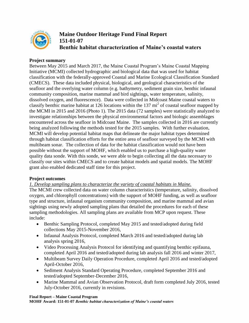
Final Report – Maine Coastal Program MOHF Award: 151-01-07 Benthic habitat characterization of Maine’s coastal waters Project summary Between May 2015 and March 2017, the Maine Coastal Program’s Maine Coastal Mapping Initiative (MCMI) collected hydrographic and biological data that was used for habitat classification with the federally-approved Coastal and Marine Ecological Classification Standard (CMECS). These data included physical, biological, and geological characteristics of the seafloor and the overlying water column (e.g. bathymetry, sediment grain size, benthic infaunal community composition, marine mammal and bird sightings, water temperature, salinity, dissolved oxygen, and fluorescence). Data were collected in Midcoast Maine coastal waters to classify benthic marine habitat at 126 locations within the 137 mi 2 of coastal seafloor mapped by the MCMI in 2015 and 2016 (Photo 1). The 2015 data (72 samples) were statistically analyzed to investigate relationships between the physical environmental factors and biologic assemblages encountered across the seafloor in Midcoast Maine. The samples collected in 2016 are currently being analyzed following the methods tested for the 2015 samples. With further evaluation, MCMI will develop potential habitat maps that delineate the major habitat types determined through habitat classification efforts for the entire area of seafloor surveyed by the MCMI with multibeam sonar. The collection of data for the habitat classification would not have been possible without the support of MOHF, which enabled us to purchase a high-quality water quality data sonde. With this sonde, we were able to begin collecting all the data necessary to classify our sites within CMECS and to create habitat models and spatial models. The MOHF grant also enabled dedicated staff time for this project. Project outcomes 1. Develop sampling plans to characterize the variety of coastal habitats in Maine. The MCMI crew collected data on water column characteristics (temperature, salinity, dissolved oxygen, and chlorophyll concentrations) with the support of MOHF funding, as well as seafloor type and structure, infaunal organism community composition, and marine mammal and avian sightings using newly adopted sampling plans that detailed the procedures for each of these sampling methodologies. All sampling plans are available from MCP upon request. These include: Benthic Sampling Protocol, completed May 2015 and tested/adopted during field collections May 2015-November 2016, Infaunal Analysis Protocol, completed March 2016 and tested/adopted during lab analysis spring 2016, Video Processing Analysis Protocol for identifying and quantifying benthic epifauna, completed April 2016 and tested/adopted during lab analysis fall 2016 and winter 2017, Multibeam Survey Daily Operation Procedure, completed April 2016 and tested/adopted April-October 2016, Sediment Analysis Standard Operating Procedure, completed September 2016 and tested/adopted September-December 2016, Marine Mammal and Avian Observation Protocol, draft form completed July 2016, tested July-October 2016, currently in revisions. Maine Outdoor Heritage Fund Final Report 151-01-07 Benthic habitat characterization of Maine’s coastal waters
Transcript of Maine Outdoor Heritage Fund Final Report 151-01-07 Benthic ... · Final Report – Maine Coastal...
Final Report – Maine Coastal Program
MOHF Award: 151-01-07 Benthic habitat characterization of Maine’s coastal waters
Project summary
Between May 2015 and March 2017, the Maine Coastal Program’s Maine Coastal Mapping
Initiative (MCMI) collected hydrographic and biological data that was used for habitat
classification with the federally-approved Coastal and Marine Ecological Classification Standard
(CMECS). These data included physical, biological, and geological characteristics of the
seafloor and the overlying water column (e.g. bathymetry, sediment grain size, benthic infaunal
community composition, marine mammal and bird sightings, water temperature, salinity,
dissolved oxygen, and fluorescence). Data were collected in Midcoast Maine coastal waters to
classify benthic marine habitat at 126 locations within the 137 mi2 of coastal seafloor mapped by
the MCMI in 2015 and 2016 (Photo 1). The 2015 data (72 samples) were statistically analyzed to
investigate relationships between the physical environmental factors and biologic assemblages
encountered across the seafloor in Midcoast Maine. The samples collected in 2016 are currently
being analyzed following the methods tested for the 2015 samples. With further evaluation,
MCMI will develop potential habitat maps that delineate the major habitat types determined
through habitat classification efforts for the entire area of seafloor surveyed by the MCMI with
multibeam sonar. The collection of data for the habitat classification would not have been
possible without the support of MOHF, which enabled us to purchase a high-quality water
quality data sonde. With this sonde, we were able to begin collecting all the data necessary to
classify our sites within CMECS and to create habitat models and spatial models. The MOHF
grant also enabled dedicated staff time for this project.
Project outcomes
1. Develop sampling plans to characterize the variety of coastal habitats in Maine.
The MCMI crew collected data on water column characteristics (temperature, salinity, dissolved
oxygen, and chlorophyll concentrations) with the support of MOHF funding, as well as seafloor
type and structure, infaunal organism community composition, and marine mammal and avian
sightings using newly adopted sampling plans that detailed the procedures for each of these
sampling methodologies. All sampling plans are available from MCP upon request. These
include:
Benthic Sampling Protocol, completed May 2015 and tested/adopted during field
collections May 2015-November 2016,
Infaunal Analysis Protocol, completed March 2016 and tested/adopted during lab
analysis spring 2016,
Video Processing Analysis Protocol for identifying and quantifying benthic epifauna,
completed April 2016 and tested/adopted during lab analysis fall 2016 and winter 2017,
Multibeam Survey Daily Operation Procedure, completed April 2016 and tested/adopted
April-October 2016,
Sediment Analysis Standard Operating Procedure, completed September 2016 and
tested/adopted September-December 2016,
Marine Mammal and Avian Observation Protocol, draft form completed July 2016, tested
July-October 2016, currently in revisions.
Maine Outdoor Heritage Fund Final Report
151-01-07
Benthic habitat characterization of Maine’s coastal waters
Final Report – Maine Coastal Program
MOHF Award: 151-01-07 Benthic habitat characterization of Maine’s coastal waters
2. Pilot the use of CMECS to characterize habitat in Maine’s coastal waters.
A contracted benthic specialist, assisted by a student intern, incorporated biological, physical,
and geological data collected and processed by the MCMI between 2013 and 2015 into CMECS,
completing the task in November 2016. A final report is available from MCP upon request.
3. Test the utility of statistical software (e.g. PRIMER) to investigate relationships between
benthic communities and their environments to enable habitat predictions statewide where
limited data are available.
The benthic specialist determined that PRIMER statistical software would provide the needed
statistical capacity to analyze marine and benthic habitat information in order to inform habitat
classification models and spatial maps. This software was purchased in December 2016 using
matching funds.
4. Generate biological and geological data layers and publish them via the Maine Coastal Atlas
website.
Starting in 2015, MCMI was able to collect additional data using more advanced water quality
monitoring equipment, purchased with the help of MOHF monies and other funding resources.
This enabled the creation of vertical profiles for additional water quality parameters, including
pH, dissolved oxygen and chlorophyll concentration for 41 of the 72 sites sampled in 2015 and
all sites sampled in 2016. Infauna and epifaunal benthic communities were also described for the
majority of sites.
A map compendium was created from hydrographic and benthic sampling surveys completed by
the MCMI in 2015. Data products include digital maps of 80mi2 of coverage for seafloor
bathymetry (meters, MLLW), backscatter intensity (indicates nature of seafloor), seafloor
textural classification (sediment type), and a point dataset of the 72 sampling site locations
within the surveyed area. Maps showing collected bathymetry and backscatter with locations of
benthic samples overlain (Figures 1 and 2) have been uploaded to the Maine Coastal Atlas Data
Repository (http://www.mainecoastalatlas.org/layers/) where they may be downloaded. Similar
products are now being completed for data collected in 2016.
5. Generate maps of known and predicted habitat and publish them via the Maine Coastal Atlas
website.
The benthic specialist used the water column, benthic community, and bathymetric data collected
in 2015 to develop a predictive model for habitat classifications. Because the majority of
samples taken in 2015 were in deeper waters, the model may be skewed towards deeper
biological communities. We are currently completing analysis of 2016 samples collected from
shallower waters in the same ecoregion, and will incorporate these results into the model before
creating predictive habitat maps. These layers will then be assimilated in ArcGIS to create a
seamless mosaic of known and predicted habitat type statewide. These maps will be shared
publically via the Maine Coastal Atlas.
Brief Summary of Project for use in MOHF newsletter and/or Facebook posts
With the support of MOHF and our other funding agencies, the Maine Coastal Program’s Maine
Coastal Mapping Initiative (MCMI) collected high-quality water quality data and benthic habitat
information that allow us to better understand our marine environment and its biological
Final Report – Maine Coastal Program
MOHF Award: 151-01-07 Benthic habitat characterization of Maine’s coastal waters
communities. The project also produced high resolution maps of bathymetry and substrate for
137 mi2 of seafloor from hydrographic surveys conducted in coastal Midcoast Maine in 2015 and
2016. With this information, the MCMI has created maps of potential benthic marine habitat for
the surveyed region. These bathymetric and habitat data have important applications for efficient
offshore permitting, enhanced coastal resiliency, and informed regional ocean planning.
Detailed Accounting
The MOHF grant provided the funding to purchase our Exo 1, state of the art water quality
monitoring sonde, and supported the part-time work of the MCMI’s student benthic assistant,
Samantha Garvey, who assisted with benthic sampling operations, infauna sample preservation
and analysis.
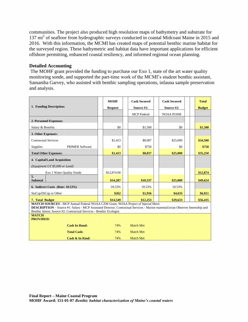
1. Funding Description:
MOHF Cash Secured Cash Secured Total
Request Source #1: Source #2:
Budget
MCP Federal NOAA POSM
2. Personnel Expenses:
Salary & Benefits $0 $1,500 $0 $1,500
3. Other Expenses:
Contractual Services
$1,413 $8,087 $25,000
$34,500
Supplies
PRIMER Software $0 $750 $0
$750
Total Other Expenses: $1,413 $8,837 $25,000 $35,250
4. Capital/Land Acquisition
(Equipment GT $5,000 or Land)
Exo 1 Water Quality Sonde $12,874.00
$12,874
5.
Subtotal $14,287 $10,337 $25,000 $49,624
6. Indirect Costs (Rate: 18.53%) 18.53% 18.53% 18.53%
StaCap/DiCap or Other $262 $1,916 $4,633 $6,811
7. Total Budget $14,549 $12,253 $29,633 $56,435
MATCH SOURCES - MCP Annual Federal NOAA CZM Grant, NOAA Project of Special Merit
DESCRIPTION – Source #1: Salary - MCP Assistand Director, Contractual Services - Marine mammal/avian Observer Internship and
Benthic Intern; Source #2: Contractual Services - Benthic Ecologist
MATCH
PROVIDED:
Cash In Hand: 74% Match Met
Total Cash: 74% Match Met
Cash & In Kind: 74% Match Met
Final Report – Maine Coastal Program
MOHF Award: 151-01-07 Benthic habitat characterization of Maine’s coastal waters
Communications
Reports detailing the MCMI data collected in 2015 have been completed and 2016 reports are in
progress. Several presentations were made for the program - presentation and report outputs are
listed below. The Maine Coastal Program is also currently working to format existing data
products for distribution through the Maine Coastal Atlas and the Northeast Ocean Data Portal.
List of reports and presentations:
Dobbs, K. 2017. High-resolution textural mapping of the inner/outer continental shelf: Cape
Small to Cape Newagen, Maine. Maine Coastal Mapping Initiative, Maine Coastal
Program, Augusta, ME. (technical report in progress)
Dobbs, K., 2017. 2016 Descriptive report for seafloor mapping: Mid-coast Maine. Maine Coastal
Mapping Initiative, Maine Coastal Program, Augusta, ME. January 2017. 86p. (technical
report)
Dobbs, K., 2017. 2016 Seafloor sediment analysis and mapping: Mid-coast Maine. Maine
Coastal Mapping Initiative, Maine Coastal Program, Augusta, ME. 119 p. (technical
report) Dobbs, K., 2016. 2015 Seafloor sediment analysis and mapping: Mid-coast Maine. Maine
Coastal Mapping Initiative, Maine Coastal Program, Augusta, ME. 22 p. (technical
report)
Dobbs, K., 2016. 2015 Descriptive report for seafloor mapping: Mid-coast Maine. Maine Coastal
Mapping Initiative, Maine Coastal Program, Augusta, ME. 45 p. (technical report)
Ozmon, I., 2016. Maine Coastal Mapping Initiative benthic infauna analyses and habitat
classification in Mid-coast Maine. Maine Coastal Program, Augusta, ME. (technical
report in progress)
Dobbs, K. Characterizing sand and gravel deposits using multibeam sonar in the Gulf of Maine.
American Shore and Beach Preservation Association 90th
Anniversary National Coastal
Conference. October 28th
, 2016. (oral presentation)
Dobbs, K., Ozmon, I., Norton, E., and M. Nixon. Maine Coastal Mapping Initiative progress
update: Applications and utilization of high resolution multibeam echosounder data.
Southern Maine Community College, Marine Technology course invitational lecture.
South Portland. November 6, 2015. (oral presentation)
Dobbs, K.. Maine Coastal Mapping Initiative progress update: Applications and utilization of
high resolution multibeam echosounder data. Maine Geological Survey Annual Meeting.
Augusta, ME. November 11, 2015. (oral presentation)
Norton, E., Dobbs, K., Ozmon, I., and M. Nixon. Under the sea: Exploring submerged geologic
features using multibeam sonar. Maine Geological Society Annual Meeting. Augusta,
ME. November 11, 2015. (poster presentation)
Nixon, M., and E. Norton. Mapping Maine’s seafloor: Maine Coastal Mapping Initiative. Port
Safety Forum. Portland, ME. December 16, 2015. (oral presentation)
Final Report – Maine Coastal Program
MOHF Award: 151-01-07 Benthic habitat characterization of Maine’s coastal waters
Figures and Photographs
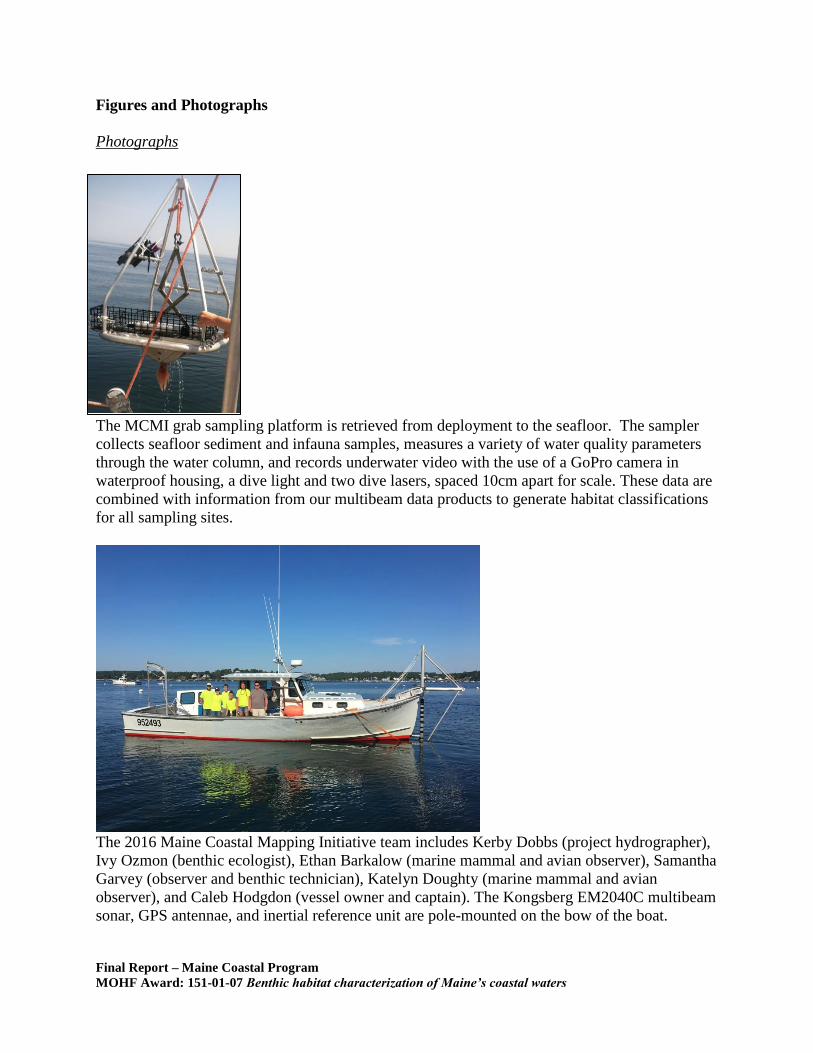
Photographs
The MCMI grab sampling platform is retrieved from deployment to the seafloor. The sampler
collects seafloor sediment and infauna samples, measures a variety of water quality parameters
through the water column, and records underwater video with the use of a GoPro camera in
waterproof housing, a dive light and two dive lasers, spaced 10cm apart for scale. These data are
combined with information from our multibeam data products to generate habitat classifications
for all sampling sites.
The 2016 Maine Coastal Mapping Initiative team includes Kerby Dobbs (project hydrographer),
Ivy Ozmon (benthic ecologist), Ethan Barkalow (marine mammal and avian observer), Samantha
Garvey (observer and benthic technician), Katelyn Doughty (marine mammal and avian
observer), and Caleb Hodgdon (vessel owner and captain). The Kongsberg EM2040C multibeam
sonar, GPS antennae, and inertial reference unit are pole-mounted on the bow of the boat.
Final Report – Maine Coastal Program
MOHF Award: 151-01-07 Benthic habitat characterization of Maine’s coastal waters
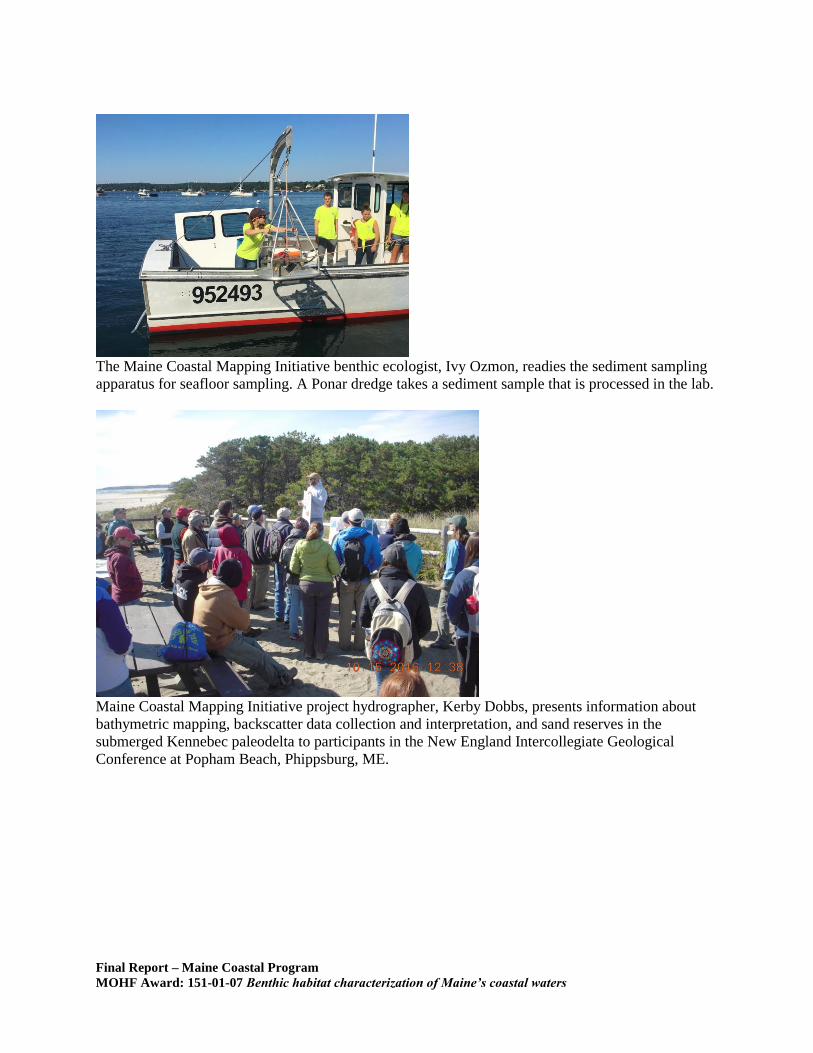
The Maine Coastal Mapping Initiative benthic ecologist, Ivy Ozmon, readies the sediment sampling
apparatus for seafloor sampling. A Ponar dredge takes a sediment sample that is processed in the lab.
Maine Coastal Mapping Initiative project hydrographer, Kerby Dobbs, presents information about
bathymetric mapping, backscatter data collection and interpretation, and sand reserves in the
submerged Kennebec paleodelta to participants in the New England Intercollegiate Geological
Conference at Popham Beach, Phippsburg, ME.
Final Report – Maine Coastal Program
MOHF Award: 151-01-07 Benthic habitat characterization of Maine’s coastal waters
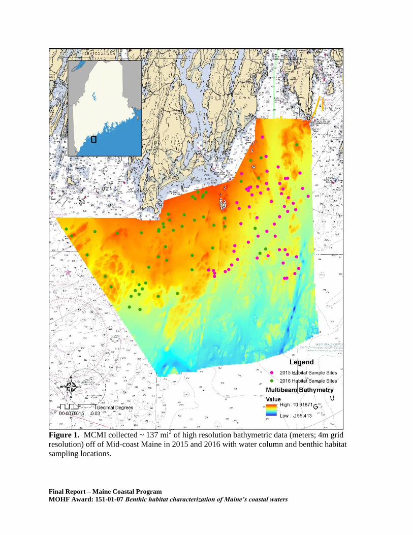
Figure 1. MCMI collected ~ 137 mi
2 of high resolution bathymetric data (meters; 4m grid
resolution) off of Mid-coast Maine in 2015 and 2016 with water column and benthic habitat
sampling locations.
Final Report – Maine Coastal Program
MOHF Award: 151-01-07 Benthic habitat characterization of Maine’s coastal waters
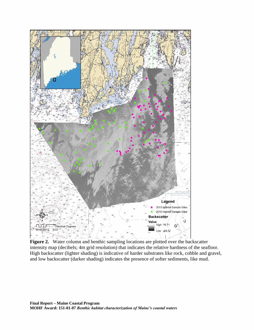
Figure 2. Water column and benthic sampling locations are plotted over the backscatter
intensity map (decibels; 4m grid resolution) that indicates the relative hardness of the seafloor.
High backscatter (lighter shading) is indicative of harder substrates like rock, cobble and gravel,
and low backscatter (darker shading) indicates the presence of softer sediments, like mud.