M. Solem Award 0734903 F. Harvey D. Wright D. Dibiase Graduate Ethics Curricula for Future...
18
M. Solem Award 0734903 F. Harvey D. Wright D. Dibiase Graduate Ethics Curricula for Future Geospatial Technology Professionals Dawn J. Wright Department of Geosciences Oregon State University David DiBiase Department of Geography & John A. Dutton e-Education Institute The Pennsylvania State University Francis Harvey Department of Geography University of Minnesota Michael Solem Director of Educational Affairs Association of American Geographers M. Solem Award 0734903 F. Harvey D. Wright D. Dibiase
-
date post
21-Dec-2015 -
Category
Documents
-
view
216 -
download
0
Transcript of M. Solem Award 0734903 F. Harvey D. Wright D. Dibiase Graduate Ethics Curricula for Future...

M. Solem
Award0734903
F. Harvey
D. Wright
D. Dibiase
Graduate Ethics Curricula for Future
Geospatial Technology Professionals
Dawn J. WrightDepartment of Geosciences
Oregon State University
David DiBiase Department of Geography & John A. Dutton e-Education Institute
The Pennsylvania State University
Francis Harvey Department of Geography
University of Minnesota
Michael SolemDirector of Educational Affairs
Association of American Geographers
M. Solem
Award0734903
F. Harvey
D. Wright
D. Dibiase
M. Solem
Award0734903
F. Harvey
D. Wright
D. Dibiase
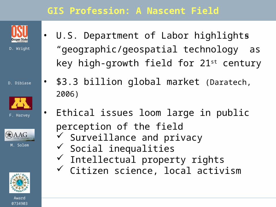
• U.S. Department of Labor highlights
“geographic/geospatial technology” as key
high-growth field for 21st century
• $3.3 billion global market (Daratech, 2006)
• Ethical issues loom large in public perception
of the field Surveillance and privacy Social inequalities Intellectual property rights Citizen science, local activism
GIS Profession: A Nascent Field
M. Solem
Award0734903
F. Harvey
D. Wright
D. Dibiase
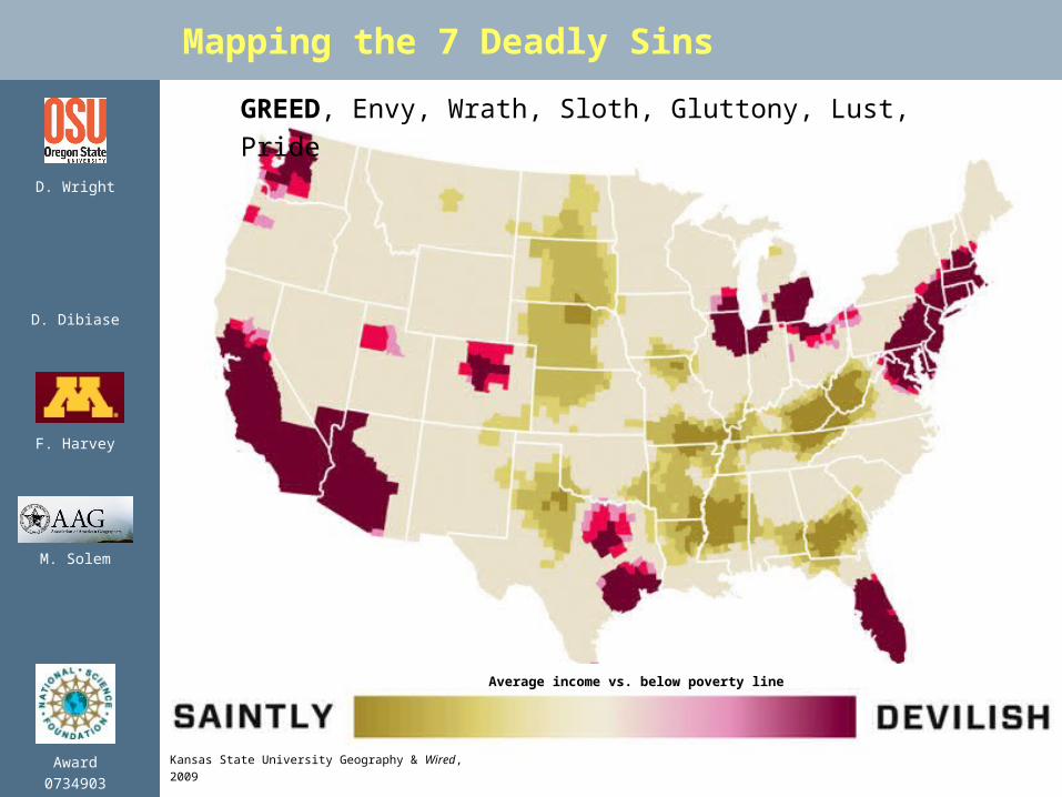
Mapping the 7 Deadly Sins
GREED, Envy, Wrath, Sloth, Gluttony, Lust, Pride
Kansas State University Geography & Wired, 2009
Average income vs. below poverty line

M. Solem
Award0734903
F. Harvey
D. Wright
D. Dibiase
• Need to prepare GIS professionals for these
challenges
• UCGIS GIS&T* Body of Knowledge includes
units on ethics among its 329 definitive topics*University Consortium for Geographic Information Science,
Geographic Information Science & Technology
• Recommended component at undergraduate,
graduate, and professional levels
• Needed as part of professional certification
process (e.g., GIS Certification Institute)
The Rise of Professional Ethics Education
M. Solem
Award0734903
F. Harvey
D. Wright
D. Dibiase
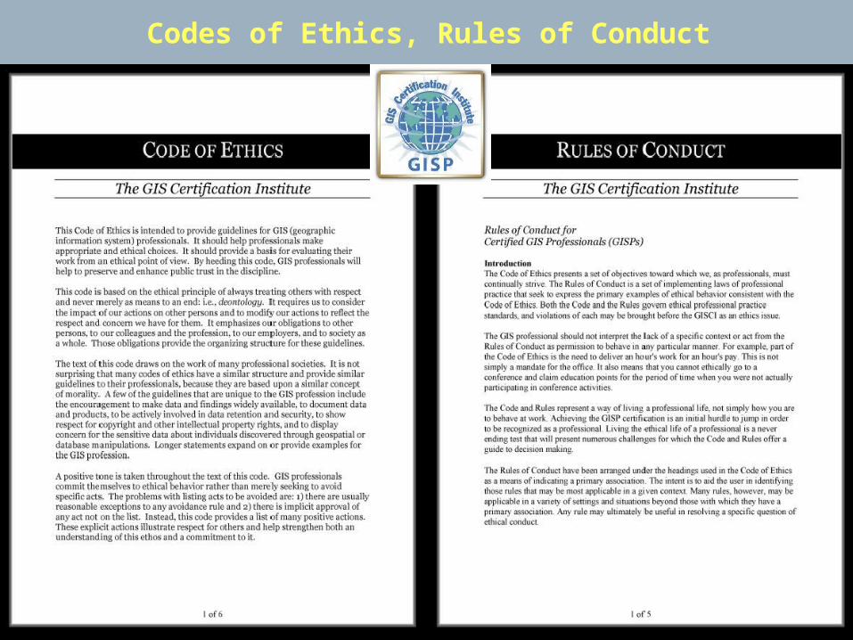
Codes of Ethics, Rules of Conduct

M. Solem
Award0734903
F. Harvey
D. Wright
D. Dibiase
• Initial special topics, graduate seminars at
OSU, PSU, Minnesota
• Transition to permanent offerings GEOG 864, Professionalism in GIS&T (PSU) GEO 567, Responsible GIS Practice: Ethics
for Future Geo Professionals (OSU) GEOG 8291, GIS Ethics: Accuracy &
Responsibility (UMn)
• Develop model curricula and associated courseware
• Disseminate open educational resources
NSF Project Goals
M. Solem
Award0734903
F. Harvey
D. Wright
D. Dibiase
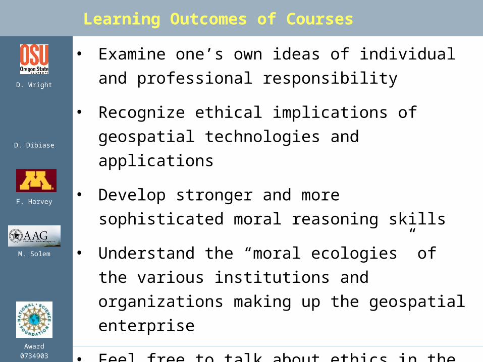
• Examine one’s own ideas of individual and
professional responsibility
• Recognize ethical implications of geospatial
technologies and applications
• Develop stronger and more sophisticated
moral reasoning skills
• Understand the “moral ecologies” of the
various institutions and organizations
making up the geospatial enterprise
• Feel free to talk about ethics in the
workplace
Learning Outcomes of Courses

M. Solem
Award0734903
F. Harvey
D. Wright
D. Dibiase
• Intro readings: philosophy, moral reasoning
• Review and discuss in-depth papers; group
discussion and activities (e.g., role play)
• Examine various codes of ethics
• Interview training and analysis
• Interaction w/ working professionals via
interviews
• Examine case studies
• Prepare and present original case studies
Pedagogical Approach
M. Solem
Award0734903
F. Harvey
D. Wright
D. Dibiase
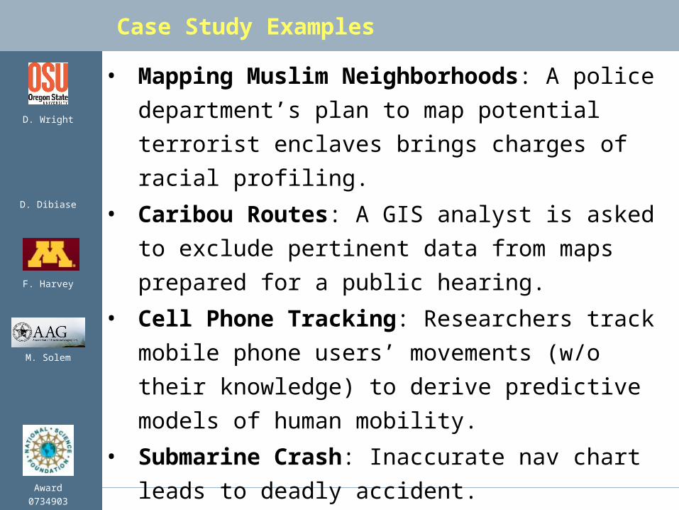
• Mapping Muslim Neighborhoods: A police
department’s plan to map potential terrorist
enclaves brings charges of racial profiling.
• Caribou Routes: A GIS analyst is asked to
exclude pertinent data from maps prepared
for a public hearing.
• Cell Phone Tracking: Researchers track
mobile phone users’ movements (w/o their
knowledge) to derive predictive models of
human mobility.
• Submarine Crash: Inaccurate nav chart
leads to deadly accident.
Case Study Examples
M. Solem
Award0734903
F. Harvey
D. Wright
D. Dibiase
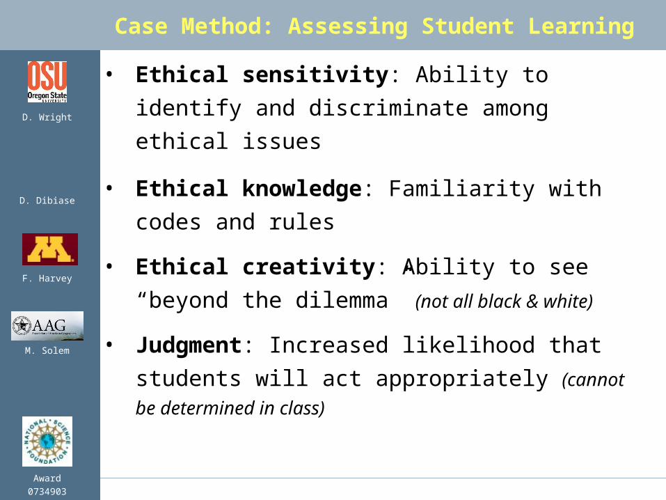
• Ethical sensitivity: Ability to identify and
discriminate among ethical issues
• Ethical knowledge: Familiarity with codes
and rules
• Ethical creativity: Ability to see “beyond
the dilemma” (not all black & white)
• Judgment: Increased likelihood that
students will act appropriately (cannot be
determined in class)
Case Method: Assessing Student Learning

M. Solem
Award0734903
F. Harvey
D. Wright
D. Dibiase
Interviews of Professionals
• Each student does
1 interview
• Develop original
case from
interview
• Opens door for
discussion of
successful or
failed approaches

M. Solem
Award0734903
F. Harvey
D. Wright
D. Dibiase
gisprofessionalethics.org
Annotated bibliography, evaluation instruments

M. Solem
Award0734903
F. Harvey
D. Wright
D. Dibiase
UCGIS Model Curricula Vision
Outcomes
SupportingTopics
andIntegrative
Experiences
Learner
GI S&T Body of KnowledgeCore

M. Solem
Award0734903
F. Harvey
D. Wright
D. Dibiase
BoK Knowledge Areas
AM. Analytical Methods
CF. Conceptual Foundations
CV. Cartography and Visualization
DA. Design Aspects
DM. Data Modeling
DN. Data Manipulation
GC. Geocomputation
GD. Geospatial Data
GS. GI S&T and Society
OI. Organizational and Institutional Aspects
M. Solem
Award0734903
F. Harvey
D. Wright
D. Dibiase
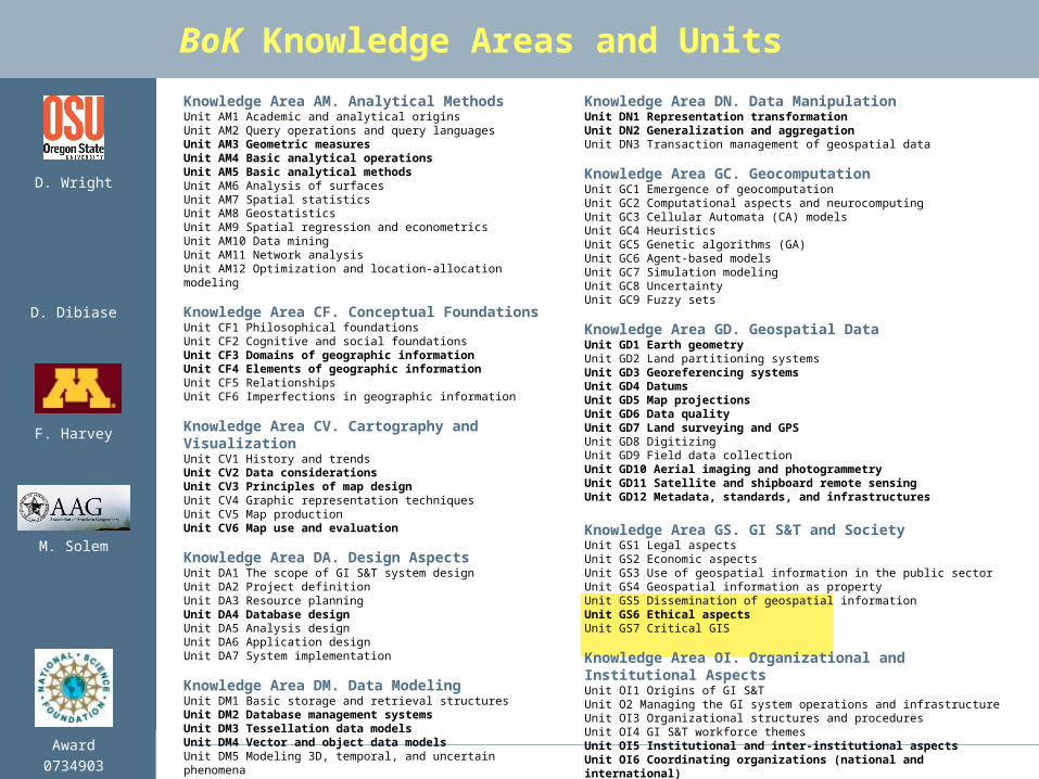
BoK Knowledge Areas and Units
Knowledge Area AM. Analytical MethodsUnit AM1 Academic and analytical originsUnit AM2 Query operations and query languagesUnit AM3 Geometric measuresUnit AM4 Basic analytical operationsUnit AM5 Basic analytical methodsUnit AM6 Analysis of surfacesUnit AM7 Spatial statisticsUnit AM8 GeostatisticsUnit AM9 Spatial regression and econometricsUnit AM10 Data miningUnit AM11 Network analysisUnit AM12 Optimization and location-allocation modeling
Knowledge Area CF. Conceptual FoundationsUnit CF1 Philosophical foundationsUnit CF2 Cognitive and social foundationsUnit CF3 Domains of geographic informationUnit CF4 Elements of geographic informationUnit CF5 RelationshipsUnit CF6 Imperfections in geographic information
Knowledge Area CV. Cartography and VisualizationUnit CV1 History and trendsUnit CV2 Data considerationsUnit CV3 Principles of map designUnit CV4 Graphic representation techniquesUnit CV5 Map productionUnit CV6 Map use and evaluation
Knowledge Area DA. Design AspectsUnit DA1 The scope of GI S&T system designUnit DA2 Project definitionUnit DA3 Resource planningUnit DA4 Database designUnit DA5 Analysis designUnit DA6 Application designUnit DA7 System implementation
Knowledge Area DM. Data ModelingUnit DM1 Basic storage and retrieval structuresUnit DM2 Database management systemsUnit DM3 Tessellation data modelsUnit DM4 Vector and object data modelsUnit DM5 Modeling 3D, temporal, and uncertain phenomena
Knowledge Area DN. Data ManipulationUnit DN1 Representation transformationUnit DN2 Generalization and aggregationUnit DN3 Transaction management of geospatial data
Knowledge Area GC. GeocomputationUnit GC1 Emergence of geocomputationUnit GC2 Computational aspects and neurocomputingUnit GC3 Cellular Automata (CA) modelsUnit GC4 HeuristicsUnit GC5 Genetic algorithms (GA)Unit GC6 Agent-based modelsUnit GC7 Simulation modelingUnit GC8 UncertaintyUnit GC9 Fuzzy sets
Knowledge Area GD. Geospatial DataUnit GD1 Earth geometryUnit GD2 Land partitioning systemsUnit GD3 Georeferencing systemsUnit GD4 DatumsUnit GD5 Map projectionsUnit GD6 Data qualityUnit GD7 Land surveying and GPSUnit GD8 DigitizingUnit GD9 Field data collectionUnit GD10 Aerial imaging and photogrammetryUnit GD11 Satellite and shipboard remote sensingUnit GD12 Metadata, standards, and infrastructures
Knowledge Area GS. GI S&T and SocietyUnit GS1 Legal aspectsUnit GS2 Economic aspectsUnit GS3 Use of geospatial information in the public sectorUnit GS4 Geospatial information as propertyUnit GS5 Dissemination of geospatial informationUnit GS6 Ethical aspectsUnit GS7 Critical GIS
Knowledge Area OI. Organizational and Institutional AspectsUnit OI1 Origins of GI S&TUnit O2 Managing the GI system operations and infrastructureUnit OI3 Organizational structures and proceduresUnit OI4 GI S&T workforce themesUnit OI5 Institutional and inter-institutional aspectsUnit OI6 Coordinating organizations (national and international)
M. Solem
Award0734903
F. Harvey
D. Wright
D. Dibiase
Ethics in the Body of Knowledge
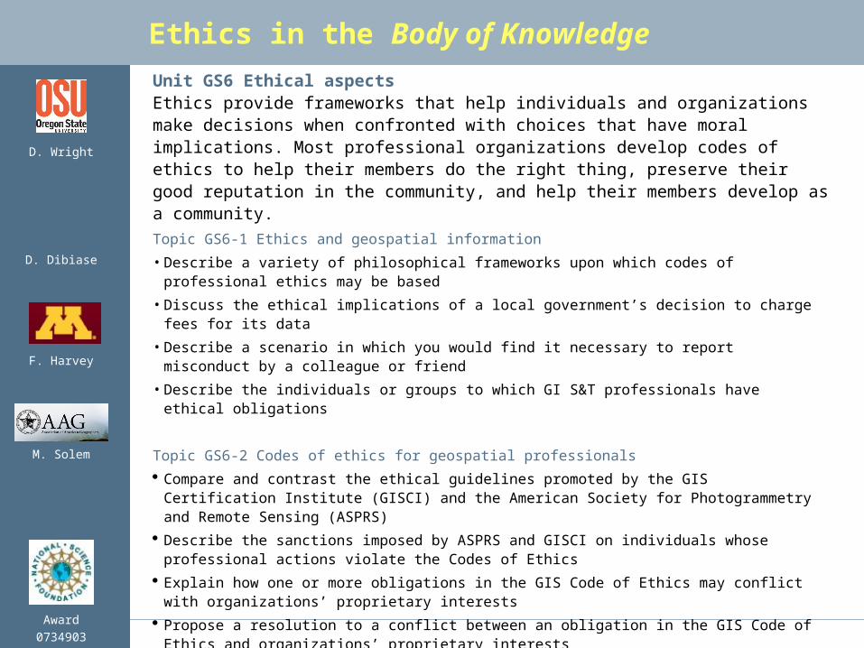
Unit GS6 Ethical aspectsEthics provide frameworks that help individuals and organizations make decisions when confronted with choices that have moral implications. Most professional organizations develop codes of ethics to help their members do the right thing, preserve their good reputation in the community, and help their members develop as a community.
Topic GS6-1 Ethics and geospatial information
• Describe a variety of philosophical frameworks upon which codes of professional ethics may be based
• Discuss the ethical implications of a local government’s decision to charge fees for its data
• Describe a scenario in which you would find it necessary to report misconduct by a colleague or friend
• Describe the individuals or groups to which GI S&T professionals have ethical obligations
Topic GS6-2 Codes of ethics for geospatial professionals
Compare and contrast the ethical guidelines promoted by the GIS Certification Institute (GISCI) and the American Society for Photogrammetry and Remote Sensing (ASPRS)
Describe the sanctions imposed by ASPRS and GISCI on individuals whose professional actions violate the Codes of Ethics
Explain how one or more obligations in the GIS Code of Ethics may conflict with organizations’ proprietary interests
Propose a resolution to a conflict between an obligation in the GIS Code of Ethics and organizations’ proprietary interests

M. Solem
Award0734903
F. Harvey
D. Wright
D. Dibiase
Ethics in the Body of Knowledge
Unit GS7 Critical GISMany of the educational objectives used to define topics in this knowledge area, and in the Body of Knowledge 2006 as a whole, challenge educators and students to think critically about GI S&T. Since the 1990s, scholars have criticized GI S&T from a wide range of perspectives. Common among these critiques are questioned assumptions about the purported benefits of GI S&T and attention to its unexamined risks. By promoting reflective practice among current and aspiring GI S&T professionals, an understanding of the range of critical perspectives increases the likelihood that GI S&T will fulfill its potential to benefit all stakeholders. Philosophical, psychological, and social underpinnings of these critiques are considered in Knowledge Area CF: Conceptual Foundations.
Topic GS7-2 Ethical critiques
Defend or refute the argument that the GI S&T professionals are culpable for applications that result in civilian casualties in warfare
Defend or refute the argument that the “digital divide” that characterizes access to GI S&T perpetuates inequities among developed and developing nations, among socio-economic groups, and between individuals, community organizations, and public agencies and private firms
Discuss the ethical implications of the use of GI S&T as a surveillance technology
M. Solem
Award0734903
F. Harvey
D. Wright
D. Dibiase
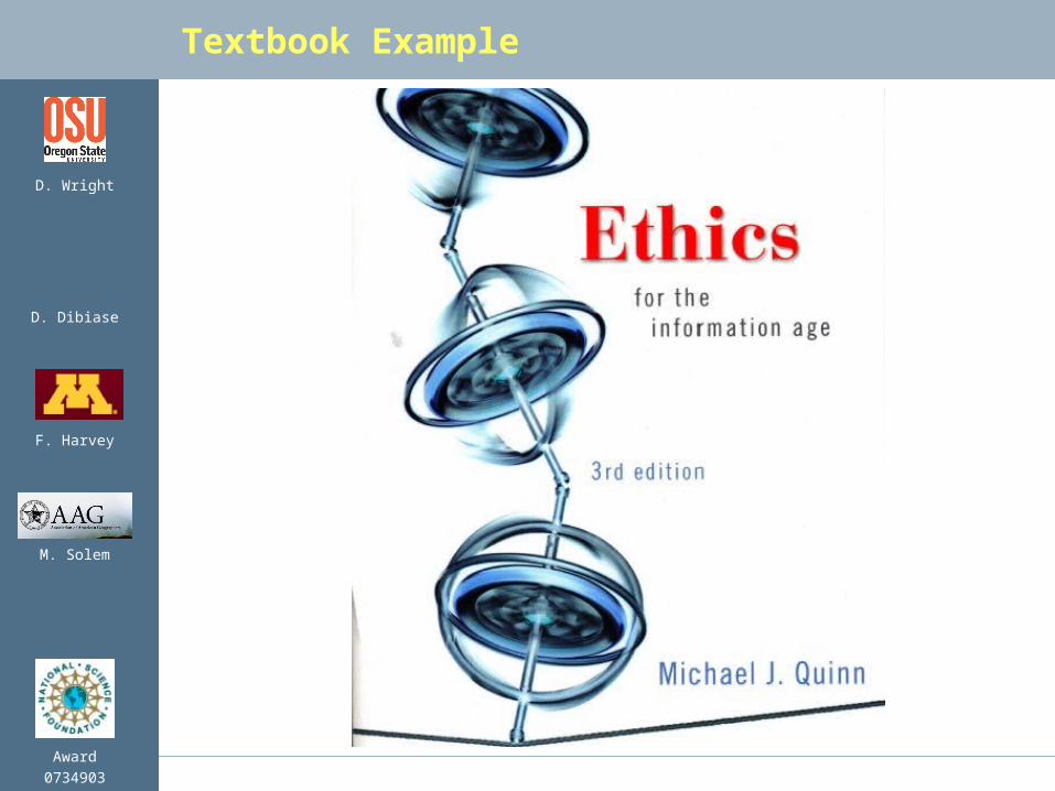
Textbook Example