M-KMA Historical Overview
123
HISTORICAL FISHERIES INFORMATION FROM THE MUSKWA-KECHIKA MANAGEMENT AREA Prepared By: Alicia Woods SS#2 Site 13 Comp 17 Fort St. John, BC V1J 4M7 For: Fisheries Branch Ministry of Environment, Lands and Parks Rm. 400 10003-110 th Avenue Fort St. John, BC V1J 6M7 January 2001
Transcript of M-KMA Historical Overview
HISTORICAL FISHERIES
INFORMATION
FROM THE MUSKWA-KECHIKA
MANAGEMENT AREA
Prepared By:
Alicia Woods SS#2 Site 13 Comp 17
Fort St. John, BC V1J 4M7
For:
Fisheries Branch
Ministry of Environment, Lands and Parks Rm. 400 10003-110th Avenue
Fort St. John, BC V1J 6M7
January 2001
Muskwa-Kechika Historical Fisheries Research Project
SUMMARY
The primary purpose of this research project was to compile and preserve historical fisheries information within the Muskwa-Kechika Management Area. This report outlines and describes, by watershed, fisheries related activities that took place over the past decades. Information gathered for this project came from personal interviews and other research. Interviews were conducted with persons from Fort St. John, Fort Nelson, Dawson Creek and other communities. The expectation of this project is to document and preserve information, that would otherwise be lost, and make it accessible for further research. In addition to preserving the past, this research will be able to provide a different outlook on past fisheries issues, and possibly bring forth new ideas and management strategies. Funding for this project was obtained through an application from BC Environment, Fisheries Section, Fort St. John, to the Muskwa-Kechika Trust Fund.
ACKNOWLEDGMENTS
Much appreciation and thanks to Nick Baccante, for direction and knowledge on this project, Paul Mitchell-Banks for his knowledge and including me on his many excursions, the Fish and Wildlife staff at the Ministry of Environment, Lands and Parks, and Rob Woods for his immeasurable amount of knowledge of the area. The author also wishes to acknowledge the Guide Outfitters of northeastern British Columbia, Fort Nelson First Nations Band, Prophet River First Nations Band and the many locals that volunteered their time and offered their knowledge to this project. Without them, this report would not be complete.
TABLE OF CONTENTS
i
Muskwa-Kechika Historical Fisheries Research Project
Summary …………………………………………………………………. i Acknowledgements ……………………………………………………….. i Table of Contents ………………………………………………………… ii List of Figures ……………………………………………………………. v List of Tables …………………………………………………………….. v List of Plates ……………………………………………………………… v List of Appendices ……………………………………………………….. vi 1.0 INTRODUCTION …………………………………………………… 1 2.0 METHODS ………………………………………………………….. 1
2.1 Description of Study Area …………………………………… 1 2.2 Methods of Study ……………………………………………. 3
3.0 LOWER HALFWAY RIVER WATERSHED ……………………… 6 3.1 Graham River ……………………………………………….. 6 3.2 Horn Creek ………..………………………………………… 9 3.3 Dolly Varden Creek ……..………………………………….. 9 3.4 Poutang Creek ………………………………………………. 10 3.5 Russel Creek ………………………………………………… 10 3.6 Lady Laurier Lake ……..……………………………………. 10
4.0 UPPER HALFWAY RIVER WATERSHED ……………………….. 14 4.1 Halfway River ………………………………………………. 14 4.2 Cypress Creek ………………………………………………. 15 4.3 Chowade River ……………………………………………… 15 4.4 Blue Grave Creek …………………………………………… 16
4.5 Robb Lake …………………………………………………… 16 5.0 UPPER SIKANNI CHIEF RIVER WATERSHED …………………. 18 5.1 Beattie Lake …………………………………………………. 18 5.2 Marion Lake ………………………………………………… 18 5.3 Cranswick Lake ……………………………………………… 19 5.4 Trimble Lake ………………………………………………… 20
5.5 Sikanni Chief Lake (Pass Lake) ..……………………………. 21 5.6 Bluebell Lake …… . ………………………………………… 22 5.7 McCusker Lake ……………………………………………… 22
5.8 Unnamed Lakes #1 ………………………………………….. 23 5.9 Sikanni Chief River …………………………………………. 23
5.10 Trimble Creek ……………………………………………… 24 5.11 Koller Creek ……………………………………………….. 24 5.12 Loranger Creek ……………………………………………. 24 6.0 UPPER PROPHET RIVER WATERSHED ………………………… 24 6.1 Fairy Lake …………………………………………………… 24 6.2 Redfern Lake ………………………………………………… 26
6.3 10 Mile Lake ………………………………………………… 28 6.4 Prophet River ………………………………………………… 28
6.5 Besa River …………………………………………………… 29 6.6 Nevis Creek ………………………………………………….. 29
ii
Muskwa-Kechika Historical Fisheries Research Project
6.7 Richards Creek ………………………………………………. 30 7.0 UPPER MUSKWA RIVER WATERSHED .. ………………………. 30 7.1 Grizzly Lake …………………………………………………. 30 7.2 Kluachesi Lake ………………………………………………. 32 7.3 Fern Lake ……………………………………………………. 32
7.4 Gathto Creek ………………………………………………… 35 7.5 Muskwa River ……………………………………………….. 35 8.0 MIDDLE MUSKWA RIVER WATERSHED ………………………. 36 8.1 Tuchodi Lakes ……………………………………………..… 36 8.2 Summit Lake ………………………………………………… 40 8.3 Tetsa Lake …………………………………………………… 41 8.4 Tuchodi River ………………………………………………. 41
8.5 Tetsa River ………………………………………………….. 43 8.6 Chischa River and Chlotapecta Creek ..…………………….. 44 9.0 DUNEDIN RIVER WATERSHED ……………..………………….. 44 9.1 Dunedin River …………………………….………………… 44 10.0 TOAD RIVER WATERSHED …………………………………….. 44 10.1 Wokkpash Lake ……………………………………………. 44 10.2 Moose Lake ………………………………………………… 45 10.3 Ram Lakes …………………………………………………. 45
10.4 Racing River ……………………………………………….. 45 10.5 Toad River …………………………………………………. 46 10.6 MacDonald Creek …………………………………………. 49 11.0 LIARD RIVER WATERSHED ……………………………………. 49 11.1 Muncho Lake ………………………………………………. 49 11.2 Grizzly Lake ……………………………………………….. 50
11.3 Unnamed Lake #2 …………………………………………. 50 11.4 Long Mountain Lake ………………………………………. 50
11.5 Fishing Lake ……………………………………………….. 51 11.6 Lapie Lake …………………………………………………. 52 11.7 Liard River ………………………………………………… 52 12.0 COAL RIVER WATERSHED …………………………………….. 53
12.1 Netson Lake ………………………………………………... 53 13.0 LOWER KECHIKA RIVER WATERSHED ……………………… 53 13.1 Birches Lake ………………………………………………. 53 13.2 Twin Island Lake ………………………………………….. 54 13.3 Solitary Lake ………………………………………………. 54 13.4 Aeroplane Lake ……………………………………………. 54 13.5 Kechika River ……………………………………………… 55 14.0 UPPER KECHIKA RIVER WATERSHED ……………………….. 55 14.1 Graveyard Lake ………………………………………….… 55 14.2 Horneline Lake ………………………………………….…. 55 14.3 Moose (Pup) Lake …………………………………..….….. 56 14.4 Scoop Lake ………………………………………………... 56 14.5 Denetiah Lake ………………………………………….….. 56 14.6 Moodie Lakes ………………………………………….….. 57
iii
Muskwa-Kechika Historical Fisheries Research Project
15.0 TURNAGAIN RIVER WATERSHED …………………………… 58 15.1 Dall Lake ………………………………………………….. 58 15.2 Rainbow Lakes ……………………………………………. 58 15.3 Blue Sheep Lake …………………………………………… 60
15.4 Turnagain River …………………………………………… 60 16.0 DISCUSSION ……………….……………………………………. 61 17.0 RECOMMENDATIONS ………………………………………….. 62 18.0 LITERATURE CITED …………………………………………….. 64 19.0 PERSONAL COMMUNICATIONS ………………………………. 66
iv
Muskwa-Kechika Historical Fisheries Research Project
LIST OF FIGURES
Figure 1: Muskwa-Kechika Management Area……………………… 3 Figure 2: Poster Soliciting Respondents For Historical
Fish Research………………………………………………. 4
LIST OF TABLES Table 1: Fish species present in the Muskwa-Kechika
Management Area ……………………………………….. 2 Table 2: Poster Distribution List …………………………….…….. 5 Table 3: Rainbow trout stocking of Fern Lake ……………………. 33
LIST OF PLATES
Plate 1: Newspaper Advertisement Requesting Information For Historical Fish Research …………………………….. 12
Plate 2. Arctic grayling caught in Lady Laurier Lake in 1995. (Picture Source: Rob Woods) …………………………… 12
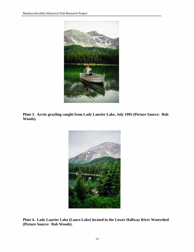
Plate 3. Arctic grayling caught in Lady Laurier Lake in July 1995. (Picture Source: Rob Woods) …………………………… 13
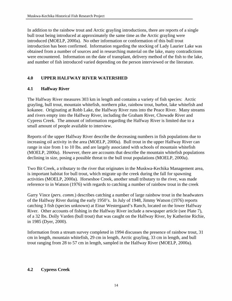
Plate 4. Lady Laurier Lake (Laura Lake) located at the head of Horn Creek. (Picture Source: Rob Woods) ……………. 13
Plate 5. Rob Woods with a bull trout angled on the Graham River, August 1990. (Picture Source: Rob Woods) …………… 8
Plate 6. Arctic grayling caught on the Graham River, August 1990. (Picture Source: Rob Woods) ……………………………. 8
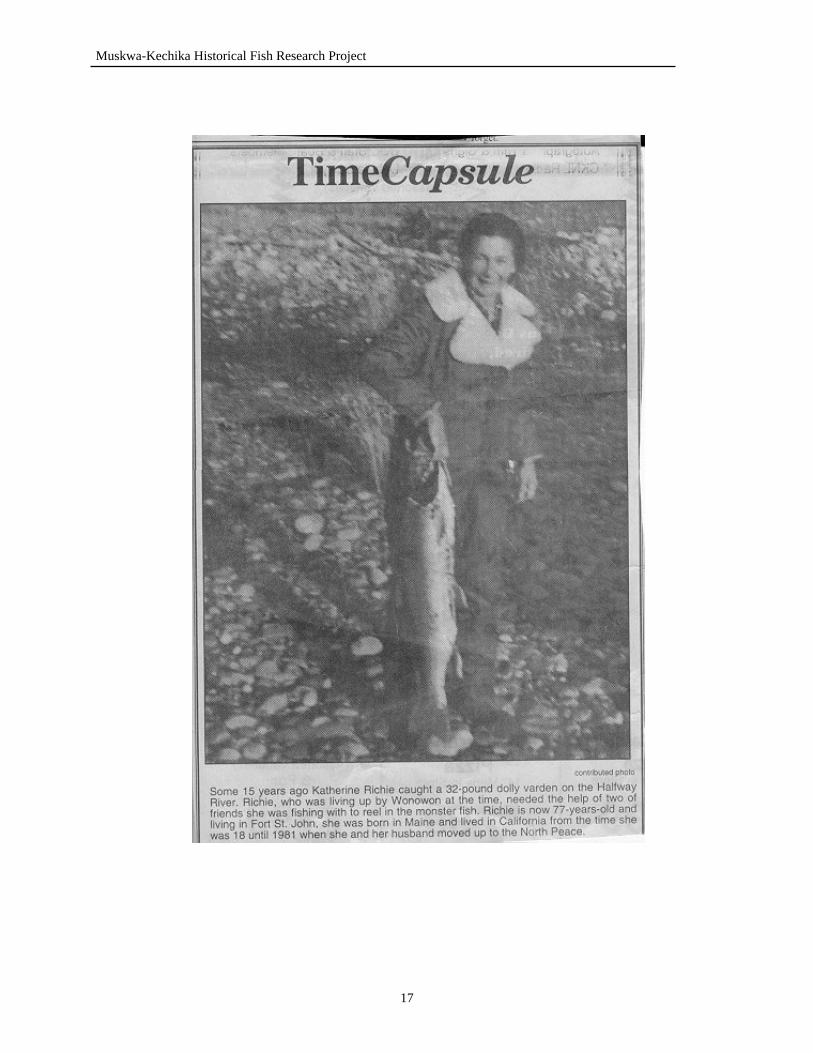
Plate 7. Dolly Varden (bull trout) caught on the Halfway River, by Katherine Richie. (Picture Source: Alaska Highway News, March 22, 2000) …………………………………… 17
Plate 8. Dolly Varden (bull trout) caught at Robb Lake in 1932. (Picture Source: Exploring for Wild Sheep in British Columbia in 1931 and 1932) ……………………………… 34
Plate 9. Don Peck and daughter, Kathy, with a rainbow trout caught from Fern Lake in the 1970’s. (Picture Source: Ross Peck) ……………………………… 34
Plate 10. Garry Vince with rainbow trout caught at Grizzly Lake. (Picture Source: Garry Vince) …………………………… 37
Plate 11. Fish caught from small lake in the Muskwa River area. (Picture Source: Garry Vince) …………………………… 37
Plate 12. Rainbow trout caught in Grizzly Lake. (Picture Source: Garry Vince) …………………………… 38
Plate 13. Bull trout caught from Grizzly Lake.
v
Muskwa-Kechika Historical Fisheries Research Project
(Picture Source: Garry Vince) ……………………….…… 38 Plate 14. Rainbow trout caught from the Muskwa River area.
(Picture Source: Garry Vince) ……………………….…… 39 Plate 15. Sandra Vince with rainbow trout caught in Grizzly Lake.
(Picture Source: Garry Vince) ……………………….…… 39 Plate 16. Fishing at the inlet of Tetsa Lake, July 1995.
(Picture Source: Rob Woods) ………………………..…… 42 Plate 17. Fishing at Tetsa Lake, July 1995.
(Picture Source: Rob Woods) ………………………..…… 42 Plate 18. Lake trout caught in Tetsa Lake, September 1971.
(Picture Source: Bob Kjos) ………………………………. 47 Plate 19. Bull trout caught on the Toad River.
(Picture Source: Bob Kjos) ………………………………. 47 Plate 20. Lake trout caught on the Toad River.
(Picture Source: Bob Kjos) ………………………………. 47 Plate 21. Terry Sawchuk and Zonk Dancevic with bull trout
caught at Ram Lakes at the head of the Toad River. (Picture Source: Rob Woods) ……………………………. 48
Plate 22. Rob Woods with bull trout caught at Ram Lakes, 1999. (Picture Source: Rob Woods) ……………………………. 48
Plate 23. Fishing at Ram Lakes. (Picture Source: Rob Woods) …… 48 Plate 24. Zonk Dancevic with rainbow trout caught at
Rainbow Lakes. (Picture Source: Rob Woods) …………. 59 Plate 25. Zonk Dancevic, Rob Woods and Terry Sawchuk
with rainbow trout caught at Rainbow Lakes. (Picture Source: Rob Woods) ……………………………. 59
LIST OF APPENDICES Appendix I: Standard Set of Questions Used During Interviews ……… 69 Appendix II: Interview Summaries …..………………………………… 70
2.1 Don Beattie - May 21, 2000 & August 14, 2000 …………… 70 2.2 Darwin Watson - May 22, 2000 …………………………….. 72 2.3 Bob Kjos - June 17, 2000 …………………………………… 73 2.4 Ross Peck - June 21, 2000 ………………………………….. 76 2.5 Jack Baker - June 21, 2000 …………………………………. 78 2.6 Leo Rutledge - June 21, 2000 ………………………………. 79 2.7 Garry Vince - June 28, 2000 ………………………………… 80 2.8 Dale Drinkall - June 28, 2000 ………………………………. 82 2.9 Olive Powell - July 2, 2000 …………………………………. 83 2.10 Dave Kyllo - July 3, 2000 ………………………………….. 84 2.11 Sherie Bradford - July 2, 2000 …………………………….. 85 2.12 Wes Brown - July 3, 2000 …………………………………. 86 2.13 Frank Cooke - July 4, 2000 ………………………………… 89 2.14 Dave Weins - July 13, 2000 ……………………………….. 92
vi
Muskwa-Kechika Historical Fisheries Research Project
vii
2.15 Ted Down - July 20, 2000 …………………………………. 93 2.16 Dwayne Palmer - July 21, 2000 …………………………… 95 2.17 Marlin Watson - July 28, 2000 …………………………….. 98 2.18 Dave Hamilton - July 28, 2000 …………………………….. 99 2.19 Brian Wolf - July 30, 2000 …………………………………. 101 2.20 Jim Hart - August 1, 2000 ………………………………….. 102 2.21 Al Hansen - August 9, 2000 ………………………………… 104 2.22 Byron Dalziel - August 9, 2000 ……………………………. 105 2.23 Myles Thorpe - August 10, 2000 …………………………… 106 2.24 Urs Schildknecht - August 14, 2000 ………………..……… 107
Appendix III: List of Interviews Recorded on Micro-cassette ………. 109 Appendix IV: List of Interviews Conducted Over the Telephone …… 109 Appendix V: Watersheds and associated contacts within the Muskwa-Kechika Management Area ………………… 110 Appendix VI: People unable to be contacted for interviews ………… 111 Appendix VII: Chowade River Fishing Lodge application
announcement ………………………………………… 112 Appendix VIII: Magazine article, in Northwest Sportsman,
on fishing the Chowade River ………………………… 113 Appendix IX: Additional Historical Literature Concerning
Northeast BC ….……………………………………… 115
Muskwa-Kechika Historical Fish Research Project
1.0 INTRODUCTION Since the creation of the Muskwa-Kechika Management Area (MKMA), there has been increasing interest in this remote area of northeastern British Columbia. This project looks at the fisheries of the Muskwa-Kechika from a historical point of view. This area of the province has remained relatively untouched until recently, when industrial developments have drawn more attention to the natural resources of the area. For years, individuals such as guide outfitters, trappers and pilots constituted the only activity within the area. The Muskwa-Kechika Management Area is a new protected area that allows activities, such as resource extractions, Guide Outfitting and recreation to remain (MOELP, 1999). The MKMA is an area that encompasses eight major watersheds and spans over 4.4 million hectares (MOELP, 1999). For many years, this area has provided opportunities for hunting and fishing. Due to the limited amount of access and the remoteness of the region, most of these activities have been restricted to those with aircraft or horses. With the growing amount of industrial development, access has increased. This is both beneficial and detrimental to this wilderness. With increased access, the picturesque beauty of the area is no longer limited to pilots and horseback riders. However, with increased access, the area is more prone to destruction and invasion by industry. Some themes that have been highlighted throughout this report include the stocking of lakes and transplanting of fish, species composition, population changes, spawning areas and habitat use, size and abundance of fish, and populations and water bodies that are at risk of being threatened. The purpose of this project was to discover the unknown fish history of the Muskwa-Kechika, by talking to those that have been most closely related to this remote area of the province. We hope to be able to preserve this information for future generations as well as learn from new-found knowledge to aid in management and preservation of the fisheries resources. 2.0 METHODS 2.1 Description of Study Area Encompassing over 4.4 million hectares of land, the Muskwa-Kechika Management Area was developed to “sustain the wilderness values of the area while allowing future resource development” (MOELP, 1999, p. 3). This unique and first of its kind management area, was allocated in October of 1997 by the Premier of British Columbia (MOELP, 1999). Since that time, interest and knowledge of northeastern British Columbia has increased. This designation has brought attention to the pristine nature and vast resources found within northeast BC. Enclosed within the Muskwa-Kechika Management Area are six newly designated parks and protected areas: Liard River Corridor, Northern Rocky Mountains, Redfern-Keily, Graham-Laurier, Denetiah, and Wokkpash protected areas. This study of historical fisheries information was conducted in the Muskwa-Kechika Management Area and the focus of information obtained remains within the MKMA. Information that is relevant to the fisheries within the Muskwa-Kechika is included, even though it may not lie within the management area boundaries. The MKMA lies roughly between the
1
Muskwa-Kechika Historical Fish Research Project
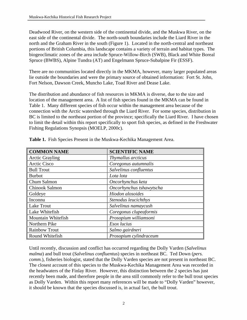
Deadwood River, on the western side of the continental divide, and the Muskwa River, on the east side of the continental divide. The north-south boundaries include the Liard River in the north and the Graham River in the south (Figure 1). Located in the north-central and northeast portions of British Columbia, this landscape contains a variety of terrain and habitat types. The biogeoclimatic zones of the area include Spruce-Willow-Birch (SWB), Black and White Boreal Spruce (BWBS), Alpine Tundra (AT) and Engelmann Spruce-Subalpine Fir (ESSF). There are no communities located directly in the MKMA, however, many larger populated areas lie outside the boundaries and were the primary source of obtained information: Fort St. John, Fort Nelson, Dawson Creek, Muncho Lake, Toad River and Dease Lake. The distribution and abundance of fish resources in MKMA is diverse, due to the size and location of the management area. A list of fish species found in the MKMA can be found in Table 1. Many different species of fish occur within the management area because of the connection with the Arctic watershed through the Liard River. For some species, distribution in BC is limited to the northeast portion of the province; specifically the Liard River. I have chosen to limit the detail within this report specifically to sport fish species, as defined in the Freshwater Fishing Regulations Synopsis (MOELP, 2000c). Table 1. Fish Species Present in the Muskwa-Kechika Management Area. COMMON NAME SCIENTIFIC NAME Arctic Grayling Thymallus arcticus Arctic Cisco Coregonus autumnalis Bull Trout Salvelinus confluentus Burbot Lota lota Chum Salmon Oncorhynchus keta Chinook Salmon Oncorhynchus tshawytscha Goldeye Hiodon alosoides Inconnu Stenodus leucichthys Lake Trout Salvelinus namaycush Lake Whitefish Coregonus clupeaformis Mountain Whitefish Prosopium williamsoni Northern Pike Esox lucius Rainbow Trout Salmo gairdneri Round Whitefish Prosopium cylindraceum Until recently, discussion and conflict has occurred regarding the Dolly Varden (Salvelinus malma) and bull trout (Salvelinus confluentus) species in northeast BC. Ted Down (pers. comm.), fisheries biologist, stated that the Dolly Varden species are not present in northeast BC. The closest account of this species to the Muskwa-Kechika Management Area was recorded in the headwaters of the Finlay River. However, this distinction between the 2 species has just recently been made, and therefore people in the area still commonly refer to the bull trout species as Dolly Varden. Within this report many references will be made to “Dolly Varden” however, it should be known that the species discussed is, in actual fact, the bull trout.
2
Muskwa-Kechika Historical Fish Research Project
2.2 Methods of Study In order to obtain historical information, research was done in Fort St. John, BC, at the local museum, library, and college. The Provincial Archives of British Columbia were also searched for information and photographs. All relevant information obtained was compiled and sorted according to watersheds within the Muskwa-Kechika Management Area. A poster was developed (Figure 2) to solicit for respondents that may have information pertaining to the project. The purpose of this poster was to draw a person’s attention to the fisheries in the area in order to obtain further contacts within the communities. The places where posters were displayed included areas of high traffic, such as post offices and grocery stores. Places where these posters were distributed are listed in Table 2. A newspaper advertisement was also placed in the local newspaper, The Alaska Highway News, (Plate 1), requesting any information regarding historical fisheries in the area. The newspaper advertisement was run in the paper for 1 day. In addition, the author was interviewed on the local television station and radio station regarding the purpose of the project undertaken, and requesting the participation of the local public in the project. The interview appeared on the television evening news for one night and on radio daily news reports during the day. No respondents were obtained by either of these three methods. In addition to preliminary and historical research, persons from within communities related to the Muskwa-Kechika were interviewed by the author. All contacts that were interviewed were obtained by way of Ministry of Environment, Lands and Parks staff, and people known by the author. Upon interviewing local persons, more potential sources of information were obtained. All interviews were conducted in a place most convenient to the interviewee. A standard set of questions was developed prior to conducting interviews, however, the questions used during the interview were not limited to those developed prior, and social conversation led to information in addition to the standard set of questions. The standard set of questions used during the interviews can be found in Appendix I. The interviews were conducted at a social level to help the interviewee feel comfortable, relaxed and to stimulate the interviewee’s memory. Additional materials, such as 1:250,000 maps, were brought along to help with the identification of water-bodies. When possible, the interviews were tape recorded using a Sony Micro Cassette Recorder. The respondents were asked prior to the commencement of the interview whether they would mind the use of the micro-recorder. Due to the location of some interviews, the use of the micro-recorder was restricted because of back-ground noise. When the micro-recorder was not used, the interviewer took handwritten notes. Some cases provided personal interviews impossible. When this was the case, telephone interviews were conducted at a time most convenient to the persons being interviewed. Upon completing the interview, the interviewee was thanked for their time and any information that they were able to provide. As soon as possible, after the interview, verbatim was examined, hand-written notes taken, and information was summarised to ensure the most accurate and
3
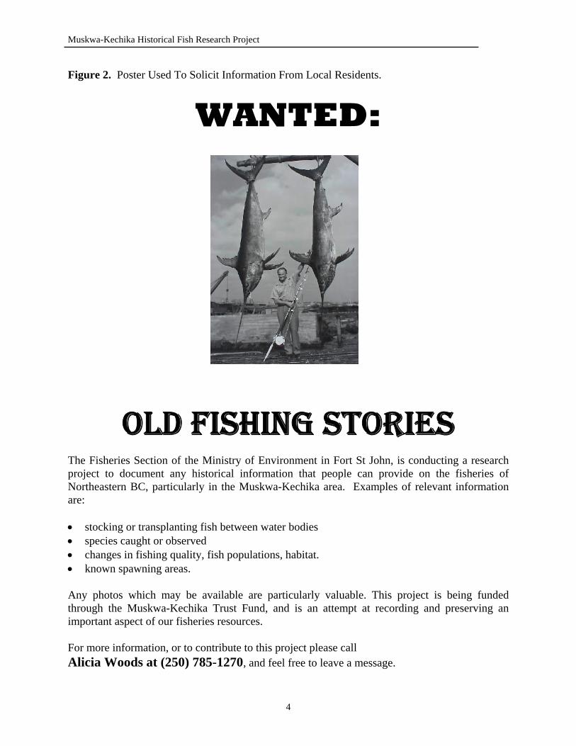
Muskwa-Kechika Historical Fish Research Project
Figure 2. Poster Used To Solicit Information From Local Residents.
WANTED:
OLD FISHING STORIES The Fisheries Section of the Ministry of Environment in Fort St John, is conducting a research project to document any historical information that people can provide on the fisheries of Northeastern BC, particularly in the Muskwa-Kechika area. Examples of relevant information are: • stocking or transplanting fish between water bodies • species caught or observed • changes in fishing quality, fish populations, habitat. • known spawning areas. Any photos which may be available are particularly valuable. This project is being funded through the Muskwa-Kechika Trust Fund, and is an attempt at recording and preserving an important aspect of our fisheries resources. For more information, or to contribute to this project please call Alicia Woods at (250) 785-1270, and feel free to leave a message.
4
Muskwa-Kechika Historical Fish Research Project
complete details. In some cases, interviewees had to be contacted again to fill in information that was missed during the interview. Any follow up questions were completed by a telephone conversation. When photographs were obtained from the interviewee, information was asked regarding the date and location of the picture, and the people and size of fish present in the picture. In some cases, this information was not known by the interviewee. All photographs acquired from the interview were scanned into a computer and returned to the owner as soon as possible. Table 2. Poster Distribution List. LOCATION CITY DATE A+W Restaurant Chetwynd, BC June 11, 2000 Shop Easy Supermarket Chetwynd, BC June 11, 2000 Winks Cornerstore Chetwynd, BC June 11, 2000 Dragon Palace Restaurant Chetwynd, BC June 11, 2000 Fas Gas Moberly Lake, BC June 11, 2000 Evie’s “Dam” Drive-In Hudson’s Hope, BC June 11, 2000 Sportsman Inn Restaurant Hudson’s Hope, BC June 11, 2000 Peace Glen Hotel Hudson’s Hope, BC June 11, 2000 Hudson’s Hope Museum Hudson’s Hope, BC June 11, 2000 Hudson’s Hope Post Office Hudson’s Hope, BC June 11, 2000 Hudson’s Hope Tourist Information Hudson’s Hope, BC June 11, 2000 Steel Toes Department Store Fort St. John, BC June 12, 2000 Fort St. John Museum Fort St. John, BC June 12, 2000 Mile 54 Alaska Highway Restaurant Fort St. John, BC June 12, 2000 Charlie Lake General Store Fort St. John, BC June 16, 2000 Cultural Centre Fort St. John, BC June 16, 2000 Humpty’s Restaurant Fort St. John, BC June 16, 2000 Overwaitea Foods Fort St. John, BC June 16, 2000 Backcountry Sports Fort St. John, BC June 16, 2000 Ministry of Environment, Lands and Parks Offices
Fort St. John, BC Fort Nelson, BC Dawson Creek, BC
June 2000
5
Muskwa-Kechika Historical Fish Research Project
3.0 LOWER HALFWAY RIVER WATERSHED 3.1 Graham River Originating in the Rocky Mountains at 56°48’ - 123°45’, south of Mt. Robb, the Graham River flows for 186 km, until it reaches its confluence with the Halfway River (MOELP, 2000a). The Graham also provides an approximate southern boundary for the Muskwa-Kechika Management Area. The Graham River is accessible by road at approximately 2.5 hours northwest of Fort St. John, at its confluence with the Halfway River. Further access to the river requires ATV or horseback. A large, cool river, the Graham provides excellent fish habitat and supports a variety of fish species (See Plates 5 & 6). Fish species present in the Graham River include Arctic grayling, bull trout, mountain whitefish and rainbow trout (MOELP, 2000). Christina Falls, located on the Graham River, presents an impassable barrier to the fish. Over 60 m (200 feet) in height, Christina Falls separates many fish populations in the Graham River. At the base of the falls and downstream on the river, rainbow trout, Arctic grayling, bull trout and mountain whitefish are present. Above the falls, the only sport fish present are bull trout. However, records exist of Arctic grayling being caught, in 1997, at the base of Red Falls which are located upstream of Christina Falls on the Graham River (Watson, M., pers. comm.). This population of Arctic grayling at Red Falls is believed to have moved downstream from a known population in Lady Laurier Lake (Watson, M., pers. comm.). The journal of James (Jimmy) Watson, former Christina Falls Ranch owner and Guide Outfitter, was obtained and proved to be a valuable source of fisheries information regarding the Graham River and surrounding area. As mentioned before, Christina Falls presents an impassable barrier to fish. Fishing occurred at the base of the falls. In August of 1971 and 1972, rainbow trout and Dolly Varden (bull trout) were caught by Jimmy and his family (Watson, 1989). Watson (1989) also describes additional accounts of fishing at the base of Christina Falls in June of 1975:
“We all went fishing at the bottom of the falls where we were able to catch rainbow, grayling, Rocky Mountain whitefish and Dolly Varden.”
Leo Rutledge (pers. comm.), former guide outfitter in the Prophet River area, recalled fishing on the Graham River, below Christina Falls in the 1940’s and catching a 21 inch rainbow trout from the pool at the base of the falls. Rutledge (pers. comm.) also described catching Dolly Varden (bull trout) above the falls during the 1940’s. Crying Girl Prairie, located approximately 24 km (15 miles) south of Christina Falls on the Graham River, also provided excellent fishing and was fished often by the Watson family. In July of 1964, Watson (1989) reports catching 13 fish (species unknown) at Crying Girl Prairie in one morning of fishing. Upstream of Christina Falls, the Graham River was fished abundantly. Red Falls, located on the Graham River, provided excellent fishing and has been fished for almost 50 years. This story, from 1952, describes the fish in the Graham River. “At the bottom of the falls [Red Falls] it looked like it should be a good place for
6
Muskwa-Kechika Historical Fish Research Project
fish. None of us knew if there were fish in the river or not. Ken Harris and his two boys went to the bottom of the falls the first night and spent quite some time fishing. Never got a bite, came back to camp, told Bob and I no fish in this river. The next day they went up on the mountain looking for rock samples. Bob and I weren’t convinced about no fish, so I was never much of a fisherman, but Bobbie was. We weren’t there long until Bob pulled out a great Dolly Varden trout about 4 lbs. We got six, all about the same size and took them to camp. I fried three of them up for supper and when Ken and his boys came in they had trouble believing we had caught all those fish where they had failed to see any sign of fish” (Watson, 1989, p. 70).
Red Falls are approximately 9 m (30 feet) tall, and prove to be good habitat for bull trout and, more recently, Arctic grayling (Watson, M., pers. comm.). In the past couple of years, a population of Arctic grayling has accumulated at Red Falls (Watson, M., pers. comm.). In August of 1964, Watson (1989) describes catching 7 Dolly Varden on the Graham River, approximately one half of a mile upstream from Red Falls. The Graham River is used extensively by the Guide Outfitters in the area. Watson (1989) describes the fishing on the trail between Christina Falls and Lady Laurier Lake as “excellent”. Guide outfitter camps are located on a number of locations along the Graham River; therefore, the river provided ample fishing opportunities to primarily supply food. In June of 1970, “The fishing was good and in between helping, the boys catch enough fish to help
out with meals” (Watson, 1989, p. 186). On many occasions, the Graham River was fished just above the falls, at the Christina Falls Ranch. Watson (1989) describes catching fish by ice-fishing on the Graham River, in 1975, at the Christina Falls Ranch. In 1966, Watson (1989) recalls that they always caught enough fish, on the Graham River, to feed themselves. Above Christina Falls, near the headwaters of the river, a fork in the river is formed due to the confluence with a unnamed tributary. On the main fork, the Graham River, there is a small set of falls. Every time Jimmy and Winnie Watson fished the pool at the base of these falls, they would be able to catch 6 to 8 fish (Watson, M., pers. comm.). As discussed earlier, the only known rainbow trout populations within the Graham River occur downstream of Christina Falls. However, an 80 cm (32 inch) rainbow trout was caught at the base of Red Falls by Jimmy and Winnie Watson (Watson, M., pers. comm.). This was the largest rainbow trout caught by the Watson family in the Graham River. The rainbow trout occurrence above Christina Falls is probably the result of the downstream movement from Lady Laurier Lake through Horn Creek.
7

Muskwa-Kechika Historical Fish Research Project
Plate 5. Rob Woods with a bull trout angled on the Graham River (Picture Source: Rob
Woods).
Plate 6. Ted Euchner with an Arctic grayling caught on the Graham River (Picture Source: Rob Woods).
8
Muskwa-Kechika Historical Fish Research Project
The only observed or known spawning activity in the Graham River is bull trout. Numerous records report bull trout spawning in the headwaters of the Graham River in the late fall (Watson, D., pers. comm.). 3.2 Horn Creek Horn Creek, 29 km in length, originates south of the headwaters of the Graham River and is a major tributary to the river (MOELP, 2000). A number of beaver dams are located on the creek, providing good habitat for bull trout. Many bull trout have been caught in the pools that are created by the beaver dams (Watson, M., pers. comm.). Many fish have been caught where Horn Creek converges with the Graham River. On several occasions in July of 1970, Watson (1989) describes fishing in the area as plentiful. “Boys and Winnie catching plenty of fish to keep us eating” (p. 187). “Caught plenty of fish for supper” (p. 187). According to Watson (1989), catching fish (species unknown) at the confluence of the Graham River and Horn Creek was never a challenge and they always caught enough for supper. The presence of other species of fish in Horn Creek has not yet been observed. However, with the recent appearance of Arctic grayling at Red Falls on the Graham River, it is probable that populations exist in Horn Creek. The outlet creek to Lady Laurier Lake flows into Horn Creek and finally the Graham River. Lady Laurier Lake is the suspected source of the Arctic grayling population at Red Falls and in order for the fish to move into the Graham River from Lady Laurier Lake, they must travel through Horn Creek. 3.3 Dolly Varden Creek Located between the Chowade and Graham Rivers, Dolly Varden Creek is a small creek, which cannot be found on a map by its name. Commonly called Dolly Varden Creek by Jimmy Watson and family, it was named after the good fishing for Dolly Varden (bull trout). In June of 1973, “Darwin came along on horseback to give me moral support and do some fishing
as this is one of the better fishing places we have in our area. We named the creek Dolly Varden Creek. Anytime we came to this spot you could throw a line in and get your fish for a meal in 10 minutes” (Watson, 1989).
This creek is not well known, and only limited amount of people know of its good fishing. The only information obtained on this creek came from the Journals of Jimmy Watson (1989). Entries from 1974 describe the abundance of fish in Dolly Varden Creek. “Winnie was able to catch enough fish for the table and I was able to trap several
beaver. All the beaver dams on this creek (we call it Dolly Varden Creek) had fish in them. Most of the dams were freshly frozen over with just enough ice to hold up a person. When we walked over the ice, we could see schools of about 10 inch Dolly Varden scurrying away under our feet” (Watson, 1989).
There are no known records of other fish species caught or observed in Dolly Varden Creek.
9
Muskwa-Kechika Historical Fish Research Project
3.4 Poutang Creek A tributary to the Graham River, Poutang Creek forms the boundary between Management Units 7-43 and 7-36. Running 31 km in length, Poutang Creek converges with the Graham River upstream of Christina Falls. There are a set of falls located on the creek, Poutang Falls. In past years, the pool at the base of the falls provided good habitat for bull trout, and proved to be excellent for fishing. “We all went fishing at Poutang Falls one day and all caught fish. This is another
beauty spot in our area that very few people ever see. The falls drop only about 40 feet but at the bottom of the drop there is a very large, round deep pool, of crystal clear water about 10 feet deep in the centre. Most times, when a person goes there and looks down you can see from 10 to 20 Dolly Varden swimming in the pool” (Watson, 1989).
Access to this creek, as well as the other creeks mentioned, is very difficult and is limited to horseback or foot. 3.5 Russel Creek Russel Creek is another creek that does not have a gazetted name. Russel Creek received its name from Jimmy Watson, who named it after a hunter that came to the area and hunted around the creek on several occasions (Watson, 1989). Similar to Horn Creek, Russel Creek has been dammed by a number of beaver dams. In the spring, during high waters, the bull trout become trapped behind the beaver dams, which provide good fish habitat and excellent bull trout fishing (Watson, M., pers. comm.). Jimmy, and clients that hunted in the area, used to catch 20 to 30 fish out of Russel Creek in a couple nights of fishing (Watson, M., pers. comm.). The average size of bull trout that were caught ranged from 40 to 45 cm (16 to 18 inches) in length (Watson, M., pers. comm.). 3.6 Lady Laurier Lake Known to locals as Laura Lake, Lady Laurier Lake has sometimes been called “the best kept secret of northern BC” (Watson, D., pers. comm.). Named Laura Lake for its location below the magnificent Mount Lady Laurier, Lady Laurier Lake is situated at 1417 m above sea level (Watson, 1989). Measuring only 3.5 km in perimeter and having a surface area of 34 hectares, Lady Laurier is a cold, clear pristine lake (See Plate 4) (MOELP, 2000b). The lake is fed by a couple of small inlet creeks and drains into an unnamed outlet creek, which flows into Horn Creek. Lady Laurier Lake was naturally a lake barren of fish (Watson, D., pers. comm.). Although the exact date is unknown, in approximately 1972 to 1973, the lake was stocked with 3000 fingerling rainbow trout (Watson, M., pers. comm.). Short Tompkins and Elmer Olsen purchased the rainbow trout from a hatchery in Campbell River and flew them to Lady Laurier Lake (Watson, D., pers. comm.). The fish were flown in to the lake in 3 barrels containing 1500 fingerlings in each. Of the 3 barrels, 2 were put in Lady Laurier Lake, and the other in Grizzly
10
Muskwa-Kechika Historical Fish Research Project
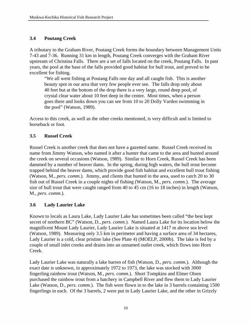
Lake, located on the Muskwa River (Watson, M., pers. comm.). The number and source of the fish are estimates, as there are no known written accounts of the stocking. Garry Vince (pers. comm.) stocked Grizzly Lake in 1971 to 1972, introducing 5000 rainbow trout from an Abbotsford hatchery. It is possible that the source of the rainbow trout introduced into Lady Laurier Lake were also from the Abbotsford hatchery. A couple of years following the introduction of rainbow trout to the lake, a mining company by the name of Brinex Mining, brought 9 to 11 Arctic grayling into Lady Laurier Lake (Watson, M., pers. comm.). The age and size of the fish introduced to the lake is unknown, as the fish were angled out of Trimble Lake. The Arctic grayling were caught in Trimble Lake and transplanted to Lady Laurier Lake by a helicopter owned by Brinex (Watson, M., pers. comm.). The rainbow trout population that was introduced to the lake did not last longer than 5 years after the stocking (Watson, M., pers. comm.). Approximately 3 to 4 years after the rainbow trout were introduced, Short Tompkins caught a few rainbow trout in Lady Laurier Lake, in the spring (Watson, M., pers. comm.). For the 5 years that rainbow were present in the lake, “the fishing was excellent” (Watson, D., pers. comm.). Fish that were caught were very large and abundant for the first 3 years following the stocking. No sign of young fish were ever seen or observed, which suggests that the rainbow trout did not reproduce in Lady Laurier Lake (Watson, D., pers. comm.). The fish that were caught, were most likely that of the original stock (Watson, D., pers. comm.). The lake was fished heavily by Guide Outfitters and hunters while the rainbow trout populations were abundant. It is suspected that the rainbow trout population was eventually fished out because of the lack of reproduction. The Arctic grayling population thrived in Lady Laurier Lake. According to Darwin Watson (pers. comm.), there were no initial indications of a survival of Arctic grayling in the lake. About the time the rainbow trout began to disappear, Arctic grayling became more apparent in the lake (Watson, D., pers. comm.). The Arctic grayling population has sustained itself since it was stocked, and still provides an excellent fishery today (See Plates 2 & 3). The average sized Arctic grayling that were caught out of the lake were approximately 45 cm (18 inches) in length. Several theories exist for why the rainbow trout population did not survive in a lake that appeared to be good habitat for rainbow trout. As mentioned before, Lady Laurier Lake is a inlet fed lake. It is suggested that the rainbow trout could not spawn in the inlet creeks, possibly due to poor spawning habitat. The Arctic grayling, did, however, spawn in the lake. In 1986, Darwin Watson (pers. comm.) describes observing abundant young fish in the outlet creek of Lady Laurier Lake. Once caught, these fish proved to be young Arctic grayling. The outlet creek is a “wild and fast creek” (Watson, D., pers. comm.). One of the inlet creeks appeared to be ideal habitat for spawning as it has a very sandy bottom (Watson, D., pers. comm.). Darwin Watson (pers. comm.) said that he has never fished the inlet creek or observed any spawning activity in either of the inlet creeks.
11
Muskwa-Kechika Historical Fish Research Project
Plate 1. Newspaper advertisement requesting information for historical fish research.
Plate 2. Arctic grayling caught in Lady Laurier Lake in 1995 (Picutre Source: Rob Woods).
12
Muskwa-Kechika Historical Fish Research Project
Plate 3. Arctic grayling caught from Lady Laurier Lake, July 1995 (Picture Source: Rob Woods).
Plate 4. Lady Laurier Lake (Laura Lake) located in the Lower Halfway River Watershed (Picture Source: Rob Woods).
13
Muskwa-Kechika Historical Fish Research Project
In addition to the rainbow trout and Arctic grayling introductions, there are reports of a single bull trout being introduced at approximately the same time as the Arctic grayling were introduced (MOELP, 2000a). No other information or conformation of this bull trout introduction has been confirmed. Information regarding the stocking of Lady Laurier Lake was obtained from a number of sources and in researching material on the lake, many contradictions were encountered. Information on the date of transplant, delivery method of the fish to the lake, and number of fish introduced varied depending on the person interviewed or the literature. 4.0 UPPER HALFWAY RIVER WATERSHED 4.1 Halfway River The Halfway River measures 303 km in length and contains a variety of fish species: Arctic grayling, bull trout, mountain whitefish, northern pike, rainbow trout, burbot, lake whitefish and kokanee. Originating at Robb Lake, the Halfway River runs into the Peace River. Many streams and rivers empty into the Halfway River, including the Graham River, Chowade River and Cypress Creek. The amount of information regarding the Halfway River is limited due to a small amount of people available to interview. Reports of the upper Halfway River describe the decreasing numbers in fish populations due to increasing oil activity in the area (MOELP, 2000a). Bull trout in the upper Halfway River can range in size from 1 to 10 lbs. and are largely associated with schools of mountain whitefish (MOELP, 2000a). However, there are accounts that describe the mountain whitefish populations declining in size, posing a possible threat to the bull trout populations (MOELP, 2000a). Two Bit Creek, a tributary to the river that originates in the Muskwa-Kechika Management area, is important habitat for bull trout, which migrate up the creek during the fall for spawning activities (MOELP, 2000a). Horseshoe Creek, another small tributary to the river, was made reference to in Watson (1976) with regards to catching a number of rainbow trout in the creek Garry Vince (pers. comm.) describes catching a number of large rainbow trout in the headwaters of the Halfway River during the early 1950’s. In July of 1948, Jimmy Watson (1976) reports catching 3 fish (species unknown) at Einar Westergaard’s Ranch, located on the lower Halfway River. Other accounts of fishing in the Halfway River include a newspaper article (see Plate 7), of a 32 lbs. Dolly Varden (bull trout) that was caught on the Halfway River, by Katherine Richie, in 1985 (Dyer, 2000). Information from a stream survey completed in 1994 discusses the presence of rainbow trout, 31 cm in length, mountain whitefish, 29 cm in length, Arctic grayling, 33 cm in length, and bull trout ranging from 28 to 57 cm in length, sampled in the Halfway River (MOELP, 2000a). 4.2 Cypress Creek
14
Muskwa-Kechika Historical Fish Research Project
Running 82 km in length, Cypress Creek is major tributary to the Halfway River (MOELP, 2000b). Fish species present in the creek include Arctic grayling, bull trout, mountain whitefish and rainbow trout (MOELP, 2000b). The creek runs parallel to the Halfway River, until it converges when the Halfway River makes a turn southward. Access to Cypress Creek is by ATV, along a designated trail, which can be accessed from Pink Mountain, on the Alaska Highway (MOELP, 1997). Historical accounts of fishing in the area include a reference made by Watson (1976) who reported catching enough fish for supper at Cypress Creek during August of 1948. A stream survey completed in 1978 reports rainbow trout, Arctic grayling and Dolly Varden (bull trout) found in Cypress Creek (MOELP, 2000a). 4.3 Chowade River The Chowade River, known to locals as the Stony River, is a moderate sized river, 87 km in length, which originates below Mt. Laurier and flows into the Halfway River (MOELP, 2000b). Fish species present in the river include Arctic grayling, bull trout, mountain whitefish and rainbow trout (MOELP, 2000b). Watson (1976) describes the Chowade River as it was in July of 1963. “The Stony [Chowade River] is a beautiful clear mountain stream and has a fair
amount of fish so we managed to catch enough fish for a good feed.” (p. 113). An abundance of research and stream surveys have been conducted on the Chowade River in the past 20 years due to the importance of bull trout habitat in the river. A beaver dam complex on the river provides an important spawning habitat for bull trout (Down, pers. comm.). Ted Down, former Fisheries Biologist in Fort St. John, states that the Chowade River experiences high fishing pressure during the fall. This can be critical to bull trout populations, as spawning activity occurs in the fall. Mountain whitefish are a common fish that rarely encounters the fishing popularity that the rainbow trout or bull trout receive. In the Chowade River, mountain whitefish are very abundant, and usually reside in the deep pools of the river (Down, pers. comm.). The mountain whitefish remain in the Chowade River system solely for feeding, and then leave the system, returning to larger water systems for the winter season (Down, pers. comm.). Down also reports that mountain whitefish are predominant in the foothills streams as far north as the Halfway River. In 1974, controversy occurred over an application to build a fishing lodge on the Chowade River (See Appendix 7). Over 15 letters were written in response to this application, opposing the building of the lodge (MOELP, 2000a). The fishing lodge application was rejected due to the susceptibility of over-fishing of the river (MOELP, 2000a). A 19 lbs. Dolly Varden (bull trout) was angled in the Chowade River, by Tim Burles, in September of 1978 (MOELP, 2000a). An article appearing in a 1974 issue of Northwest Sportsman Magazine describes fishing for Dolly Varden, rainbow trout and mountain whitefish in the Chowade River (See Appendix 8) (Fryer, 1974).
15
Muskwa-Kechika Historical Fish Research Project
4.4 Blue Grave Creek
Although located outside of the Muskwa-Kechika Management Area, the importance of Blue Grave Creek, and its relationship to the Halfway River Watershed is critical to fisheries in the area. Blue Grave Creek converges with the Halfway River, just prior to the Halfway River’s confluence with the Graham River (MOELP, 1997). Mountain whitefish, rainbow trout, Arctic grayling and bull trout have been recorded to be present in Blue Grave Creek.
The importance of this creek is the habitat it provides for spawning bull trout (Down, pers. comm.). In 1989, research was completed on the creek and the spawning activity of bull trout, and high densities of juvenile bull trout were found (Down, pers. comm.). Two to three years later, additional research was done on the spawning activity of bull trout, and no bull trout were found to be present in the stream (Down, pers. comm.). Forest harvesting occurred prior to the second research period, and theories suggest that the logging around Blue Grave Creek, opened up the forest canopy, thus increasing the water temperature of the creek. Down (pers. comm.) reports bull trout are sensitive to water temperature, and require temperatures of approximately 12°C, while the Blue Grave Creek had water temperatures of 18 to 19°C. 4.5 Robb Lake Located between Mt. Kenny and Mt. Robb, Robb Lake is located at an elevation of 1410 m above sea level (MOELP, 2000b). Robb Lake has a perimeter of 3.4 km and a surface area of 59 hectares (MOELP, 2000b). Information discovered regarding Robb Lake was very minimal, and therefore the fish history of the lake is virtually unknown. Historical fish information did, however, arise while researching literature. In July of 1931, the fishing at Robb Lake was described: “The trout refused to rise for a fly, but as we were fishing for food, I felt any
mode of catching them was fair” (Sheldon, 1981, p. 53). Sheldon (1981) further describes the fishing experience at Robb Lake during the summer of 1931: “We landed 5 beauties including one measuring twenty-two inches long” (p. 53). Dolly Varden (bull trout) were the only fish species caught in Robb Lake by the hunting group in 1931 (Sheldon, 1981). No other mention was made of other fish being caught or observed in the lake. Picture references from Sheldon (1981), illustrate the fish angled at Robb Lake in 1931 (See Plate 8). Plate 7. Dolly Varden (bull trout) caught on the Halfway River by Katherine Richie (Picture Source: Alaska Highway News, March 22, 2000).
16
Muskwa-Kechika Historical Fish Research Project
17
Muskwa-Kechika Historical Fish Research Project
5.0 UPPER SIKANNI CHIEF RIVER WATERSHED 5.1 Beattie Lake Located south of the Sikanni Chief River and below Mt. Wooliever, Beattie Lake, 57°11’ - 123°18’, has become well known for its rainbow trout populations. Having a perimeter of 4.5 km and a surface area of 58 hectares, Beattie Lake is a small, cool and non-glacial lake (MOELP, 2000b). For a number of years, Beattie Lake was primarily an alias name used by guide outfitters. Named after guide outfitter, Don Beattie, this lake was not well known except by those in the area. Years ago, it was also referred to as Zipper-mouth Lake, because for many years no one knew of the rainbow trout population present in the lake (Brown, pers. comm.). Beattie Lake outlets into Koller Creek and ultimately, the Sikanni Chief River. The only known fish species present in the lake are rainbow trout. Beattie Lake was barren prior to the introduction of rainbow trout (Beattie, pers. comm.). In 1978, Don Beattie stocked the lake with 5000 fingerling rainbow trout from a hatchery located near Mission, BC (Beattie, pers. comm.). The rainbow trout were brought to the lake in a small plane, and dropped into the water from a height of approximately 100 feet from the water surface (Beattie, pers. comm.). When asked about how the impact of hitting the water affected the fish, Don Beattie (pers. comm.) replied that they did not know how the fall affected the fish, however, they also never noticed any abundance of dead fish following the stocking. Don Beattie stocked many lake in his guide territory. He believed this lake would support a rainbow trout fishery due to its cold waters and the absence of glacial waters (Beattie, pers. comm.). The rainbow trout are believed to spawn around the outlet of Beattie Lake and throughout Koller Creek. In June of 1999, observations were made of 50 to 60 rainbow trout attempting to spawn below the outlet of Beattie Lake, in Koller Creek (MOELP, 2000a). Beattie Lake has built a reputation of having an excellent rainbow trout fishery. In June of 1999, there are records of 3 rainbow trout being caught, ranging in size from 45 to 50 cm (18 to 20 inches) in length (MOELP, 2000a). There is also a report of a 14 lbs. rainbow trout angled out of the lake (MOELP, 2000a). As with the information for the Lower Halfway River Watershed, many contradictions and discrepancies arise in the data compiled for Beattie Lake. Contradictions occur in the date of the stocking and in the source of the fish. Discussion with Don Beattie revealed a Mission hatchery as the source of the introduced rainbow trout. However, literature and historical files discuss an Abbotsford hatchery as the source of the rainbow trout in Beattie Lake (MOELP, 2000a). 5.2 Marion Lake Positioned at 1275 m above sea level, Marion Lake, 57°07’18” - 123°08’15”, is located northwest of Pink Mountain in the Upper Sikanni Chief Watershed (MOELP, 2000b). Marion Lake has a perimeter of 7.4 km, a surface area of 121 hectares and mean depth of 2.3 m. Located south of the Sikanni River, Marion Lake drains into Loranger Creek, and ultimately into the Sikanni Chief River.
18
Muskwa-Kechika Historical Fish Research Project
The only known sport fish species present in the lake is Arctic grayling. The Arctic grayling population is not natural to the lake. In the early 1970’s, Don Beattie (pers. comm.) stocked Marion Lake with an unknown amount of Arctic grayling. Prior to the introduction, the only known fish species in the lake included longnose suckers (Catostomus catostomus) and lake chub (Couesius plumbeus) (MOELP, 2000a). The Arctic grayling introduced to the lake were angled out of Trimble Lake and transported, by float plane, to Marion Lake (Beattie, pers. comm.). The exact size range and life stage of the fish transplanted is unknown, but was greatly varied. Once caught, the Arctic grayling were placed in plastic containers which had hoses strewn to the exterior of the plane to attempt to provide necessary oxygen (Beattie, pers. comm.). Don Beattie (pers. comm.) stated that in order for the fish to survive, the transplant had to take place within forty minutes of being placed in the plastic containers. Other accounts of stocking occur for Marion Lake. Dwayne Palmer (pers. comm.) reports that Don Beattie and Lynn Ross (former guide outfitter in the Halfway River area) stocked Marion Lake with rainbow trout and Arctic grayling. Palmer (pers. comm.) describes that both fish species are still present in the lake today; however, the rainbow trout never grew to be large sized fish. Reasoning for this lack of large rainbow trout is related to amount of food. Palmer (pers. comm.) reports that Marion Lake is a shallow lake, causing the fish to remain dormant during the winter due to lack of available oxygen. He suggests that with a lack of food and a state of dormancy during winter months, the rainbow trout were not able to achieve large sizes (Palmer, pers. comm.). Spawning location of the Arctic grayling, is known to be upstream in Loranger Creek. Observations of Arctic grayling suggest that spawning of this species occurs during the early spring, when the ice retreats from the lake, from late April to May (Beattie, pers. comm.). The transplant of Arctic grayling proved to be successful and the lake presently supports a stable population which provides an excellent Arctic grayling fishery. In 1982, lake surveys completed on Marion Lake, found Arctic grayling 16 to 18 cm (6 to 7 inches) in length (MOELP, 2000a). 5.3 Cranswick Lake Cranswick Lake is located at the headwaters of Trimble Creek at an elevation of 1448 m above sea level (MOELP, 2000b). Its perimeter measures 5.2 km and it has a surface area of 72 hectares (MOELP, 2000b). Local guide outfitter, Don Beattie, stocked many lakes in this area with various species of fish. However, Beattie reports that Cranswick Lake was never stocked, but believed it would be an excellent lake to introduce fish into because it is spring fed and does not encounter glacial waters (Beattie, pers. comm.). Contradicting the reports of Arctic grayling present in the lake, Beattie (pers. comm.) described a number of beaver dams present on Trimble Creek, which prevent Arctic grayling from moving upstream, from Trimble Lake, into Cranswick Lake. However, beaver dams are not static obstructions, and can easily be destroyed or changed, allowing continuous flow through the creek and possibly permitting fish to move upstream.
19
Muskwa-Kechika Historical Fish Research Project
Information obtained for Cranswick Lake conflicted in many areas. Dwayne Palmer, former guide outfitter in the Besa River area, reported that Don Beattie stocked Cranswick Lake with rainbow trout in the time period of 1975 to 1978 (Palmer, pers. comm.). When asked if he stocked the lake, Beattie replied that he never stocked the lake with rainbow trout or Arctic grayling, but believed it would provide excellent habitat for fish introductions (Beattie, pers. comm.). There are recent records (June 1999) of observations of Arctic grayling present in the outlet of the lake, Trimble Creek (MOELP, 2000a). The approximate size range of the observed Arctic grayling was 35 to 50 cm (14 to 20 inches) in length (MOELP, 2000a). This record suggests that the Arctic grayling have moved upstream from Trimble Lake and could reside in Cranswick Lake. 5.4 Trimble Lake A large lake, Trimble Lake, 57°16’ - 123°36’, measures 12 km in perimeter and its surface area covers 314 hectares (MOELP, 2000b). Positioned at 1265 m above sea level, Trimble Lake lies beneath Mt. Trimble, north of the Sikanni Chief River. The average depth of the lake is 13.9 m (MOELP, 2000b). The lake is fed by 17 inlet streams; Trimble Creek being the major inlet and outlet of the lake. Trimble Lake is one of the few lakes in the Muskwa-Kechika Management Area that has designated access routes. A designated trail for ATV or horseback use can be entered from a seasonal road, north of Sikanni River, on the Alaska Highway (MOELP, 1997). Trimble Lake has been a target of many stocking and transplanting activities within the southern portion of the Muskwa-Kechika Management Area. Fish species present in the lake include Arctic grayling, bull trout, mountain whitefish and rainbow trout (MOELP, 2000a). As mentioned previously, Trimble Lake was the source of the Arctic grayling that were angled and transplanted to Lady Laurier Lake (Watson, M., pers. comm.). It is not known whether Trimble Lake was barren of fish before fish introductions occurred. Records indicate that Arctic grayling and mountain whitefish were first introduced to Trimble Lake in 1959 by an oil company, Standard Oil, working on the west side of the Rocky Mountains (MOELP, 2000a). The source of these fish is not known for certain, but records suggest Pelly Lake, in the Finlay River area as the source of the mountain whitefish and Arctic grayling (MOELP, 2000a and Beattie, pers. comm.). Two shipments of fish were brought over to Trimble Lake; the first load containing 17 grayling and the second containing 19 grayling (Beattie, pers. comm.). Don Beattie (pers. comm.) reported that Arctic grayling were brought over, but was not aware of mountain whitefish introductions during this transplant. The fish were transported to Trimble Lake by a Beaver plane (Beattie, pers. comm.). Additional records exist that guide outfitter, Don Beattie, stocked Arctic grayling a second time in 1964, and a third time in 1979 into Trimble Lake (MOELP, 2000a). de Laronde (1997) discusses the 1979 stocking, which introduced 40 Arctic grayling into Trimble Lake, from an unknown source. However, Don Beattie (pers. comm.) was contacted a second time (August 14, 2000) and he stated that he never stocked Trimble Lake, and the only stocking of the lake, to his
20
Muskwa-Kechika Historical Fish Research Project
knowledge, was the Arctic grayling introduced by Stanland Oil in 1959, and the rainbow trout stocking by the Ministry of Environment in 1984. Wes Brown (pers. comm.), former guide outfitter in the Besa River area, reported that Arctic grayling were angled at the bottom of the falls at the outlet of Fairy Lake, and transplanted to Trimble Lake. The Arctic grayling were placed in washtubs, and transported, by helicopter to Trimble Lake (Brown, pers. comm.). The date of the transplant and number of fish moved is unknown, and no other records exist of this transplanting. However, skepticism arises with this account of Arctic grayling being caught at the base of the Fairy Lake falls. Presently, no Arctic grayling populations exist in the lake, and the only other account of Arctic grayling associated with Fairy Lake is the transplant of 50 Arctic grayling from Trimble Lake to Fairy Lake in 1978 to 1979 (Palmer, pers. comm.). The Ministry of Environment stocked Trimble Lake in September of 1984 with 5000 rainbow trout from the Loon Creek Hatchery, located near Clinton, BC (MOELP, 2000a). The life stage of the introduced fish is unknown. This stocking was done to enhance and promote the fisheries in the area. Spawning timing and locations in Trimble Lake occur in the inlet and outlet creeks. In 1974, observations were made of the inlet and outlet creeks being used for spawning (species unknown) (MOELP, 2000a). Arctic grayling are known to spawn in the outlet creek, Trimble Creek, during early spring (May) (Beattie, pers. comm. and Brown, pers. comm.). Don Beattie (pers. comm.) described that from the plane, the outlet creek would be black with spawning Arctic grayling. Trimble Lake is a very popular fishing and recreation location for many people in northern BC, as well as throughout the province. Wes Brown (pers. comm.) recalled when the Arctic grayling were transplanted into Trimble Lake, the area became more popular for fishing activities and received a noticeable increase in traffic. Accounts of fishing groups taking more than 100 Arctic grayling out of Trimble Lake per visit have circulated, but never confirmed (Brown, pers. comm.). Brown (pers. comm.) described that at one time, Trimble Lake experienced over-fishing during winter months because of the increased fishing activity and access during the winter season. 5.5 Sikanni Chief Lake Found at the headwaters of the Sikanni Chief River, Sikanni Chief Lake is known to local guide outfitters as Pass Lake (Beattie, pers. comm.). Located at 57°15’ - 124°07’, Pass Lake measures 7.5 km in perimeter and has a surface area of 88 hectares (MOELP, 2000b). Accessible by horseback or aircraft only, this lake is situated on the western boundary of the Muskwa-Kechika Management Area. Fish species present in the lake include Arctic grayling (MOELP, 2000b). The Arctic grayling are not natural to this lake (Beattie, pers. comm.). In the early 1980’s, Don Beattie (pers. comm.) brought 30 Arctic grayling to Pass Lake in a float plane, flown by Elmer Olsen. With the help of a fisheries biologist from Prince George, BC, the fish were captured using a tranquilizing powder
21
Muskwa-Kechika Historical Fish Research Project
from Trimble Lake, and transported by aircraft to Pass Lake (Beattie, pers. comm.). de Laronde (1997) reports that a single bull trout was introduced to the lake, however, no other information was located regarding this introduction (de Laronde, 1997). Presently, Arctic grayling are still in Pass Lake and a stable population has been established (de Laronde, 1997). The Arctic grayling transplanted into Pass Lake have moved downstream and have populated the Sikanni Chief River. Other lakes along the river, providing physical barriers do not prevent access to the lake, have also been populated by this downstream movement (Beattie, pers. comm.). 5.6 Bluebell Lake Located along the Sikanni Chief River, Bluebell Lake is an alias name to an unnamed lake. This lake, known to very few, was named by Don Beattie and was naturally barren of fish (Beattie, pers. comm.). In approximately 1985, Beattie (pers. comm.) stocked Bluebell Lake with rainbow trout which came from Beattie Lake. Thirty fish were angled from Beattie Lake, placed in plastic containers and flown to Bluebell Lake. The lake also contains Arctic grayling, which have moved downstream from Pass Lake (Sikanni Chief Lake) and have entered Bluebell Lake. There are no barriers which prevent the movement of fish into or out of Bluebell Lake. Beattie (pers. comm.) reported that the rainbow trout freely move downstream, into the Sikanni River, and it is not known whether a present rainbow trout population still exists in Bluebell Lake. However, the stocking of Bluebell Lake with rainbow trout, has helped to populate the species throughout the Sikanni Chief River. 5.7 McCusker Lake A lake that is only known to those in the Sikanni Chief River area, McCusker Lake is an alias name used by Don Beattie and present guide outfitters (Beattie, pers. comm.). Located near Bluebell Lake, at the headwaters of the Sikanni Chief River, McCusker Lake was naturally barren of fish. In 1985, Beattie (pers. comm.) stocked McCusker Lake with 30 rainbow trout. The fish were angled from Beattie Lake and brought to McCusker Lake by plane (Beattie, pers. comm.). Beattie (pers. comm.) stated that McCusker Lake becomes “washed out” during high waters of the Sikanni Chief River. Rainbow trout were never caught from McCusker Lake; Don Beattie (pers. comm.) believes that the fish were swept downstream during periods of high waters and never remained in the lake. Although no records exist of rainbow trout present in McCusker Lake, the stocking of the small, unknown lake has introduced a population to the Sikanni Chief River watershed. Don Beattie (pers. comm.) believes that the stocking of Bluebell and McCusker Lakes has resulted in the rainbow trout populations present in the Sikanni Chief River system today. 5.8 Unnamed Lakes #1 Located directly south of the Sikanni Chief River, a report of rainbow trout stocking exists for these unnamed lakes. Dwayne Palmer (pers. comm.) discussed that Don Beattie stocked these lakes, in the time period of 1975 to 1978, with rainbow trout. Recent accounts exist of these
22
Muskwa-Kechika Historical Fish Research Project
lakes producing good rainbow trout fishing (Palmer, pers. comm.). The lakes were barren before the introduction of the rainbow trout. When questioned, Don Beattie (pers. comm.) stated that he did not stock these lakes with rainbow trout. The location of the lakes was described over the telephone, so potential error could have been encountered. However, Don Beattie has spent a large amount of time in the area, and appeared to comprehend and understand the lakes which were being discussed. 5.9 Sikanni Chief River Stretching over 395 km in length, the Sikanni Chief River originates in the Rocky Mountains and flows into the Fort Nelson River, where its final outcome is the Arctic Ocean (MOELP, 2000b). The Sikanni Chief River is fairly accessible, as the ATV trail to Trimble Lake follows along the river. However, beyond Trimble Lake, access becomes restricted to horseback or aircraft. The river is crossed by the Alaska Highway, allowing direct access to certain portions of the stream. A major set of falls are located on the river which prevent the movement of fish upstream beyond the falls (MOELP, 2000b). Naturally, the Sikanni Chief River, above the falls was barren of fish (Beattie, pers. comm.). However, with the introductions of rainbow trout, and Arctic grayling to the many lakes upstream of the falls, the Sikanni Chief River is now populated with a number of different fish species. Throughout the river, Arctic grayling, bull trout, burbot, mountain whitefish and rainbow trout can be found regularly (MOELP, 2000b). As mentioned before, Arctic grayling have moved downstream from Pass Lake and can now be caught upstream of the falls. Rainbow trout stocked in Bluebell Lake and McCusker Lake have also developed populations above the falls. The stocking of Trimble Lake with Arctic grayling, in 1959, and rainbow trout, in 1984, have also helped in creating viable populations throughout the upper Sikanni Chief River. Garry Vince (pers. comm.), guide outfitter in the Muskwa River area, reported fishing in the north Sikanni River. Vince (pers. comm.) described catching 8 to 10 Arctic grayling and bull trout during one day of fishing.
“There is still good fishing in the upper Sikanni, but it is not a good as what it used to be” (Vince, pers. comm.).
Vince (pers. comm.) also commented that the pools on the Sikanni Chief River were always good for fishing. 5.10 Trimble Creek Trimble Creek, 26 km in length, flows out from Cranswick Lake, through Trimble Lake and into the Sikanni Chief River and provides important habitat for spawning Arctic grayling (MOELP, 2000b). The outlet of Trimble Lake is a primary location for the Arctic grayling populations in Trimble Lake to spawn during the early spring months (Beattie, pers. comm. and Brown, pers.
23
Muskwa-Kechika Historical Fish Research Project
comm.). A set of impassable falls are located on Trimble Creek, approximately 4 km from the mouth of Trimble Lake (MOELP, 2000b). This prevents the movement of fish upstream Trimble Creek into Trimble Lake and Cranswick Lake. However, many fish have moved downstream into the Sikanni Chief River, from the upstream water-bodies (Beattie, pers. comm.). Sport fish species present in Trimble Creek include Arctic grayling and rainbow trout (MOELP, 2000a). 5.11 Koller Creek Koller Creek, located upstream of the Sikanni River falls, is a tributary to the Sikanni Chief River and the outlet creek of Beattie Lake. Running over 18 km in length, Koller Creek contains Arctic grayling, mountain whitefish and rainbow trout (MOELP, 2000b). The rainbow trout populations are wild naturalized, possibly from Trimble Lake, while the mountain whitefish are indigenous to the stream (MOELP, 2000a). A set of impassable falls are located on the creek, at the outlet of Beattie Lake (MOELP, 2000b). This set of falls, prevents fish immigration to Beattie Lake, but allows for movement downstream out of the lake. The falls provide an explanation for the natural absence of fish in Beattie Lake. Koller Creek is an important location for the spawning activity of rainbow trout populations in the Sikanni Chief River (MOELP, 2000a). Above the falls on Koller Creek, the outlet of Beattie Lake is used extensively for spawning by rainbow trout populations in Beattie Lake (MOELP, 2000a). 5.12 Loranger Creek Loranger Creek flows out of Marion Lake and measures 23 km in length (MOELP, 2000b). Similar to Koller Creek, Loranger Creek is tributary to the Sikanni Chief River and provides important spawning habitat for Arctic grayling present in the Sikanni Chief River. Fish species present in the creek include Arctic grayling, mountain whitefish and rainbow trout. The presence of Arctic grayling and rainbow trout in Loranger Creek is due to the stocking of Trimble and Marion Lakes (MOELP, 2000a). 6.0 UPPER PROPHET RIVER WATERSHED 6.1 Fairy Lake Located near the headwaters of the Besa River, Fairy Lake, 57°20’ - 123°54’, is a popular lake and well known for its rainbow trout fishing (MOELP, 1997). Fairy Lake is situated at an elevation of 1356 m above sea level (MOELP, 2000b). A moderate sized lake, Fairy Lake has a perimeter of 9 km, a surface area of 151 hectares and a mean depth of 29.9 m (MOELP, 2000b). Access to Fairy Lake is permitted through a designated trail which can be entered from Mile 178 on the Alaska Highway (MOELP, 1997). The trail, however, does not allow direct access to the lake, as it continues up the shores of Redfern Lake (MOELP, 1997). Known fish species occurring in Fairy Lake include rainbow trout (MOELP, 2000b). However, these fish did not reside in the lake naturally. According to Dwayne Palmer (pers. comm.), Fairy Lake was a clear and cold lake that was barren of all fish. Brown (pers. comm.) also reported the absence of fish in Fairy Lake, however, he also commented that,
24
Muskwa-Kechika Historical Fish Research Project
“there were lots of bugs there [Fairy Lake], so you could see it was an alive lake.”
At the outlet of Fairy Lake there is a set of falls. Described by Palmer (pers. comm.), these falls are not steep, but long. The falls prevent the movement of fish upstream into the lake, but allow the downstream movement of fish into Fairy Creek and further into the Besa River (Palmer, pers. comm.). Fairy Lake was stocked a number of times, by both guide outfitters and the Ministry of Environment, Lands and Parks. In 1978, an unknown amount of rainbow trout were introduced into Fairy Lake by the local guide outfitters. The fingerling rainbow trout were purchased from Dave Chillie, and flown from their Alberta hatchery to a dugout, owned by Dwayne Palmer, where they were kept (Palmer, pers. comm.). Prior to the fish being dropped into the lake, several bags of manure, containing freshwater shrimp populations, were placed in the lake to enhance the rainbow trout potential by providing an additional food source (Palmer, pers. comm.). The purchased rainbow trout were placed in horse troughs, in cold water, for 2 to 3 months (Palmer, pers. comm.). Once the fish reached a size of 20 to 23 cm (8 to 9 inches) in length, they were then dropped from the plane, into Fairy Lake (Palmer, pers. comm.). Fairy Lake was stocked a second time, with rainbow trout, by the Ministry of Environment, Lands and Parks in September of 1984 (MOELP, 2000a). A total of 10,000 rainbow trout, from the Loon Creek Hatchery, Clinton, BC, were introduced into the lake to provide and promote recreational fisheries in the area (MOELP, 2000a). Reports of Arctic grayling being introduced into Fairy Lake also exist. Approximately 50 Arctic grayling were angled out of Trimble Lake in 1978 to 1979, and brought over, by packhorse, to Fairy Lake (Palmer, pers. comm.). The stocking of rainbow trout in Fairy Lake proved to be successful, as presently, rainbow trout have populated the lake and created a popular area for rainbow trout fisheries. Palmer (pers. comm.) reported that following the transplant of Arctic grayling, no fish were ever caught or observed by himself, or others, to his knowledge. There have been no subsequent reports of Arctic grayling caught or observed in Fairy Lake within the literature researched. However, an Arctic grayling population does exist below the falls, in Fairy Creek (MOELP, 2000b). The freshwater shrimp introduced to the lake, during the initial rainbow trout stocking, took time to develop a stable population within the lake (Palmer, pers. comm.). For a number of years, the fish were “long and skinny”, when they were first introduced (Palmer, pers. comm.). In past years, the fish have become more developed and are much heavier in body size (Palmer, pers. comm.). Fairy Lake has produced a number of good sized rainbow trout. Palmer (pers. comm.) remembers the largest rainbow trout caught was 10 to 11 lbs., but states that, on average, the size of fish ranged from 3 to 4 lbs. Brown (pers. comm.) reported that he often ice-fished on Fairy Lake, but never had much success. Fly-fishing, during summer months, proved to be the most successful method of catching rainbow trout, and would yield rainbow trout 5 to 6 lbs. in size (Brown, pers. comm.). More recent reports of fishing at Fairy Lake include a 60 to 65 cm (24 to 26 inch) rainbow trout caught by Don Hoffman in July of 1995, and a 117 cm (47 inch) rainbow trout caught in 1997 (MOELP, 2000a).
25
Muskwa-Kechika Historical Fish Research Project
Fairy Lake is part of the Besa River system, which experiences glacier waters during times of warm weather and annual run-off (Palmer, pers. comm.). Fairy Lake, in comparison to Redfern Lake, is not severely affected by the glacier waters (Brown, pers. comm.). Above Fairy Lake there is a much smaller lake, half of one mile in length, which “acts like a sediment bowl”, collecting the silt and debris from the glacial run-off (Brown, pers. comm.). This “sediment bowl” keeps Fairy Lake clear of the glacial silt, and provides better fish habitat (Brown, pers. comm.). Spawning activities in Fairy Lake were observed at the outlet of the lake (Palmer, pers. comm.). During late May, following the retreat of ice cover, a sow and cub grizzly bear were seen standing at the mouth of the river, scooping fish from the outlet (Palmer, pers. comm.). Dwayne Palmer (pers. comm.) reported that the bears remained there the entire day, and believes that this was a location of the spawning rainbow trout. Fairy Creek, outlet of the lake, contains a different fish population structure than that of Fairy Lake. Fish species present in Fairy Creek include Arctic grayling and mountain whitefish (MOELP, 2000b). The falls, located on the creek at the outlet of the lake, provide an impassable barrier to fish moving upstream, providing an explanation for the absence of mountain whitefish and Arctic grayling populations within Fairy Lake. However, no reports have been found regarding the presence of rainbow trout in Fairy Creek. Whether rainbow trout do, in fact, reside in the outlet creek is not known. 6.2 Redfern Lake One of the most well known lakes in the Muskwa-Kechika Management Area, Redfern Lake is a lake that is enjoyed by many who enjoy the scenic outdoors. Located at 57°21’ - 123°54’, beneath Mt. Redfern and at the headwaters of the Besa River, Redfern Lake provides ample outdoor recreation opportunities (MOELP, 2000a). A large lake, Redfern has a perimeter of 15 km, a surface area of 539 hectares and a mean depth measuring 43.5 m. At an elevation of 1264 m above sea level, Redfern Lake is inlet fed and drains into the Besa River (MOELP, 1997). In 1931, a group of hunters, described Redfern Lake as 6 miles long,
“bordered on three sides by craggy, snow-topped mountains” and “on its fourth side the rocky slopes of the razor-backed mountain taper directly into the lake” (Sheldon, 1981, p. 82).
Access into Redfern Lake is permitted by a designated trail, gaining entry from Mile 178 on the Alaska Highway (MOELP, 1997). The trail follows Nevis Creek, and up along the shores of the lake and is limited to use by ATV and horseback only (MOELP, 1997). A variety of fish species occur in Redfern Lake. Fish native to the lake include lake trout, Arctic grayling and bull trout (MOELP, 2000a). Rainbow trout are now present in the lake (MOELP, 2000a). The rainbow trout populations were stocked by the Ministry of Environment, Lands and Parks in September of 1984 (MOELP, 2000a). Approximately 10,000 rainbow trout, from the Loon Creek Hatchery, were stocked into the lake to create a recreational fishery (MOELP, 2000a). de Laronde (1997) discusses speculations that the lake was stocked prior to the 1984 stocking, by a local guide outfitter. However, no records were found regarding this speculation.
26
Muskwa-Kechika Historical Fish Research Project
Wes Brown (pers. comm.), guide outfitter in the area since 1937, described that “Redfern Lake never looked good for fishing.”
Due to its location, Redfern Lake experiences an the influx of glacier waters during periods of warm weather or yearly run-off seasons (Brown, pers. comm.). During this time, vegetation in the lake often becomes covered with a white silt, and the lake would appear to turn white (Brown, pers. comm.). Although, it appeared to be low-quality habitat for fish, Brown (pers. comm.) reported abundant large-sized fish present in the lake. Brown (pers. comm.) believes that the fish remain on the bottom of the lake when the waters become silty. The most popular fish species sought after and caught were lake trout (Brown, pers. comm). Some of the lake trout would reach weights of 20 lbs. or more (Brown, pers. comm.). Fishing for lake trout was the best during the fall or winter months, September to late October, because the lake would be clear of silt (Brown, pers. comm. and Palmer, pers. comm.). Brown (pers. comm.) states other fish present in the lake included mountain whitefish, Arctic grayling and rainbow trout; the latter being stocked after he left the area. Brown (pers. comm.) recalled that it was “sometimes hard to even catch a feed of fish on the lake.” Stories have been told of trappers in the area claiming to have caught a 70 lbs. rainbow trout out of Redfern Lake (Brown, pers. comm.). The largest fish caught by Brown (pers. comm.) in Redfern Lake was a 20 lbs. lake trout. Brown (pers. comm.) remembers Don Beattie fishing the lake during the fall, and catching 4 to 5 rainbow trout that measured approximately 36 inches in length. Brown (pers. comm.) described the packboxes being 20 inches wide, and the fish would hang over the edges of the packbox an additional 16 to 18 inches. In 1977, Dolly Varden (bull trout) and lake trout were reported to have been seen or caught in Redfern Lake and in 1981, a stream survey was conducted and revealed lake whitefish, 24 cm to 27 cm in length, and lake trout measuring 12 to 77 cm in length (MOELP, 2000a). Spawning is believed to occur in the Besa River outlet (MOELP, 2000a). Brown (pers. comm.) described Redfern Lake as being the most popular area for recreational fishing, and it was the most heavily fished by the general public. Fishing was mediocre; one was able to catch only 2 to 3 fish at a time, and once in awhile a large fish would be caught (Brown, pers. comm.). The attraction to Redfern Lake was the knowledge that the lake contained very large rainbow trout and lake trout (Brown, pers. comm.). Brown (pers. comm.) believes that Redfern Lake is not a lake that could be easily over-fished because of the lack of fish movement, due in part to the presence of silty waters during certain times of the year. Increasing access and boat use would pose threats to Redfern Lake’s fish populations (Brown, pers. comm.). 6.3 10 Mile Lake 10 Mile Lake, named by local guide outfitters, is located on the headwaters of a tributary to the Besa River (Palmer, pers. comm.). Rainbow trout, presumably part of the same stock that came from Alberta, were put in the lake by Dwayne Palmer, who brought them into the lake in packboxes (Palmer, pers. comm.). However, rainbow trout were never caught out of 10 Mile Lake (Palmer, pers. comm.). 10 Mile Lake is a shallow lake, and it is speculated that when the
27
Muskwa-Kechika Historical Fish Research Project
lake froze over during the winter, a lack of oxygen prevented the fish from populating the small lake (Palmer, pers. comm.). 6.4 Prophet River The Prophet River originates in the Rocky Mountain, and runs for 292 km until its confluence with the Muskwa River, near Fort Nelson, BC (MOELP, 1997). The river supports a wide variety of fish species including Arctic grayling, bull trout, burbot, inconnu, mountain whitefish and northern pike (MOELP, 2000b). A large number of streams flow into the Prophet River: Richards Creek, Besa River, and Minaker River (MOELP, 1997). Leo Rutledge (pers. comm.), former guide outfitter in the Prophet River area, described the Prophet River system as poor fishing. Arctic grayling were present in the system; averaging 45 cm (18 inches) in length (Rutledge, pers. comm.). Areas that proved to be good fishing for Arctic grayling included the confluence with Richards Creek and the confluence with the Minaker River. Brown (pers. comm.) reported that virtually all the creeks flowing into the Prophet River contained fish. There were never large quantities of fish, however, if a good pool was found, it usually resulted in 6 to 7 fish being caught (Brown, pers. comm.). Streams in conjunction with the Prophet River are glacier fed, which results in silty waters and less fish production (Rutledge, pers. comm.). Brian Wolf (pers. comm.), representative for the Prophet River First Nations, described the Prophet River as the most important stream to the First Nations, as it was the closest stream which provide fishing opportunities. Many population changes have been noticed for the Prophet River and its tributaries (Wolf, pers. comm.). A dramatic change in the size of fish was first observed in the 1980’s. The size of fish being caught decreased in size by half; previously, fish being caught were up to 3 feet in length, and presently the fish do not get larger than 18 inches (Wolf, pers. comm.). Populations have also decreased beginning in the late 1980’s, believed to be due to over-fishing in the area (Wolf, pers. comm.). Physiological changes, such as exterior lumps, have also been noticed on the fish being caught in the Prophet River and its tributary streams (Wolf, pers. comm.). Spawning in the area occurs in all of the small tributaries to the Prophet River (Wolf, pers. comm.). Stream surveys completed on the river report spawning activity occurring in the upper Prophet River (MOELP, 2000a). Spawning activity has often been observed in Adsett Creek, a minor tributary (Wolf, pers. comm.). Fishing quality, stream habitat and fish populations are affected predominantly by the accumulation of glacier silt (Wolf, pers. comm.). Before the introduction of the “hook and line” method of fishing, the Prophet River First Nations Band used more traditional methods for catching fish in the rivers. In the major rivers, fish snares and nets were the primary methods of catching fish (Wolf, pers. comm.). A fishing technique used in smaller streams, usually during spawning runs, was the “Indian Fish Net”:
“A medium-sized log was laid across the creek, in water that was approximately 6 inches deep. Spruce boughs were cut and placed in the stream bed, on the downstream side of the log. Willow boughs backed up and supported the spruce boughs. While spawning, fish moving upstream would try to push through the
28
Muskwa-Kechika Historical Fish Research Project
spruce and willow boughs, but would become wedged, allowing for easy capture” (Wolf, pers. comm.).
6.5 Besa River The Besa River originates south of Great Snow Mountain, in an area of the Rocky Mountains which consists of a number of glaciers, including the Ithaca Glacier (MOELP, 1997). These glaciers are the primary reason for the common siltyness of Redfern Lake and occasionally of the rivers. The glacier run-off would also affect Keily Creek, which originates in the Rocky Mountains, near the glacier field. Keily Creek runs for 41 km, until its confluence with the Besa River (MOELP, 2000b). The Besa River runs 101 km in length before it converges with the Prophet River (MOELP, 1997). Known fish species found in the Besa River include Arctic grayling, bull trout, and lake trout (MOELP, 2000a). The Besa River was good fishing, except when the waters were high, and when the glaciers would start running (Palmer, pers. comm.). Brown (pers. comm.) reported the Besa River being good fishing for bull trout. A small set of falls on the Besa River created a pool that proved to be excellent fish habitat and provided good fishing (Brown, pers. comm.). The lower Besa River, did not provide the fishing quality that the upper portion of the river did (Brown, pers. comm.). Due to fast waters, it was harder to fish, and only a few fish would be caught (Brown, pers. comm.). In 1977, a stream survey conducted discovered bull trout, Arctic grayling and lake trout present in the Besa River (MOELP, 2000a). Records exist of the Mary G. Henry group fishing in Keily Creek in July of 1930, but no fish were seen or caught (Henry, 1934b). 6.6 Nevis Creek Nevis Creek is a tributary to the Besa River, which originates east of Mt. Dopp and runs 36 km in length (MOELP, 2000b). Nevis Creek is easily accessed from Mile 178 on the Alaska Highway, by a designated trail which runs along its length, on route to Redfern Lake (MOELP, 1997). Fish species known to occur in Nevis Creek include rainbow trout, bull trout and Arctic grayling (Palmer, pers. comm.). According to Palmer (pers. comm.), Nevis Creek has better fishing quality than both the Besa and Prophet Rivers. However, the fishing quality usually depended on the water level of the Besa River, with June and July being best times to catch fish in Nevis Creek (Brown, pers. comm. and Palmer, pers. comm.). With low water levels, a gravel bar would restrict the movement of fish upstream into Nevis Creek from the Besa River (Brown, pers. comm.). Palmer (pers. comm.) reported that, to his knowledge, the largest bull trout taken from Nevis Creek weighed 4 lbs. and the average size rainbow trout caught was 2 ½ lbs. Arctic grayling, however, where the most dominant and popular fish, and fly fishing proved to be the best method for catching the fish (Palmer, pers. comm.). One year, two 10 lbs. fish (species unknown) were caught by Brown (pers. comm.) out of Nevis Creek. Brown (pers. comm.) described the fishing: “You could see the fish, put a bait in, let it float down, and the fish would be on
the line.”
29
Muskwa-Kechika Historical Fish Research Project
The confluence of the Besa River and Nevis Creek allowed for good fishing, provided the water levels were sufficient to allow the fish to move upstream into Nevis Creek (Brown, pers. comm.). Nevis Creek also provided important spawning habitat for fish (Palmer, pers. comm.). Palmer (pers. comm.) explained that during the spring, “the crazy fish”, Arctic grayling, would be trying to move upstream Nevis Creek when there was very little water present. 6.7 Richards Creek Richards Creek is a major tributary to the Prophet River, that runs 54 km in length (MOELP, 2000b). The most common species present in Richards Creek is bull trout, however, all the tributary streams to the Prophet River contained Arctic grayling (Palmer, pers. comm.). The fishing in Richards Creek was mediocre, and the best time to catch fish was usually during June and July (Palmer, pers. comm.). Fishing for bull trout at the confluence of Richards Creek and the Prophet River was generally good quality and occasionally a 10 lbs. bull trout would be caught from the area (Brown, pers. comm.). Brown (pers. comm.) detailed fishing in Richards Creek: “If you find a big hole, then generally you would find one big trout.” Even when the water levels were low, the pools in the creek would provide good fishing and fish habitat (Brown, pers. comm.). In July of 1930, Mary G. Henry and family fished in Richards Creek and caught Arctic grayling, which they called Arctic trout (Henry, 1934b). 7.0 UPPER MUSKWA RIVER WATERSHED 7.1 Grizzly Lake Located at the headwaters of a tributary to the Muskwa River, Grizzly Lake was named by guide outfitter, Garry Vince (pers. comm.). Grizzly Lake, 57°52’ - 123°54’, is a spring fed, landlocked lake, located at an elevation of 1195 m above sea level (MOELP, 2000b and Vince, pers. comm.). Small in size, Grizzly Lake has a perimeter of only 1.7 km and a surface area of 19 hectares (MOELP, 2000b). Access into Grizzly Lake is permitted by horseback only, as the lake is not large enough for access by float plane (Palmer, pers. comm.). Fish species known to be present in the lake are Arctic grayling and rainbow trout (Vince, pers. comm.). Grizzly Lake was barren prior to the introductions of rainbow trout, Arctic grayling and bull trout (Vince, pers. comm.). The initial stocking of the lake occurred in 1960, when Garry Vince (pers. comm.) brought 2 bull trout and 3 Arctic grayling into the lake, by horseback. Angled out of Crehan Creek, the fish were transported in packboxes for 2.5 hours to Grizzly Lake (Vince, pers. comm.). The packboxes were filled with water, and in order to keep the fish alive, frequent stops had to be made at streams and rivers to replenish the water supply (Vince, pers. comm.). The lake was stocked with rainbow trout on July 12, 1964, when 5000 fingerling rainbow trout were flown into the lake (Vince, pers. comm.). Purchased from Loon Creek Hatchery, the fish were dropped from the plane at an altitude of 80 feet above the water surface and at a speed of 80 miles per hour (Vince, pers. comm.). The lake was stocked with rainbow trout a second time,
30
Muskwa-Kechika Historical Fish Research Project
in 1971 to 1972, with an additional 5000 fingerling rainbow trout which came from a hatchery in Abbotsford, BC (Vince, pers. comm.). Vince (pers. comm.) reported the rainbow trout grew large and fast, and he believes this was due to the excellent freshwater shrimp population that was present in the lake (See Plates 10, 12, 13 & 15). The rainbow trout spawned in the lake for a few years, but then the populations seemed to decrease (Vince, pers. comm.). Vince (pers. comm.) believes that there were too many fish for the amount of freshwater shrimp population available in the lake. The average size of rainbow trout angled from Grizzly Lake was 35 cm (14 inches) in length; however, they have caught rainbow trout up to 10 lbs. in weight (Vince, pers. comm.). In December of 1975, Jimmy Watson reports his fishing experience at Grizzly Lake: “Garry flew us to a small lake that he had stocked with rainbow trout and we tried
fishing through the ice, but had no luck” (Watson, 1989). Approximately 8 to 10 years ago, fewer and fewer rainbow trout were being caught, and fishing quality started to decline (Vince, pers. comm.). Vince (pers. comm.) believes that there are very few, if any, rainbow trout still present in the lake today. However, in 1999, a 10 lbs. rainbow trout was caught from Grizzly Lake by Mac Watson (Watson, M., pers. comm.). The Arctic grayling that were transplanted into the lake in 1960 prospered, and have built a stable population within Grizzly Lake (Vince, pers. comm.). Within the first year following the introduction, the 2 bull trout were fished out by Garry Vince and his crew, and bull trout have not been caught in the lake since (Vince, pers. comm.). Spawning of the Arctic grayling population is believed to occur by wave action or shore spawning, and speculations occur of whether this method of spawning was used by the rainbow trout as well (Vince, pers. comm.). 7.2 Kluachesi Lake Kluachesi Lake, known to locals as Blue Lake, is located north of the Muskwa River and south of Gathto Creek (MOELP, 1997). An inlet fed lake, Kluachesi is situated at 1134 m above sea level (MOELP, 2000b). Kluachesi Lake has a perimeter of 14.9 km, and a surface area of 220 hectares; however, the average depth of the lake is only 2 m (MOELP, 2000b). Access to Kluachesi Lake, like most other mountain lakes, is restricted to horseback or aircraft (MOELP, 1997). Although a considerable amount of literature exists on Kluachesi Lake, little is known of the fisheries in the lake. Many species are found in the lake, including Arctic grayling, bull trout, and burbot. It is not known whether the Arctic grayling, bull trout or burbot occur in Kluachesi Lake naturally, or whether they were introduced. Olive and Gary Powell guided in the Gathto Creek and Kluachesi Lake area beginning in 1960, when guide area were allotted (Powell, pers. comm.). In Kluachesi Lake, Arctic grayling, burbot and bull trout were caught (Powell, pers. comm.). Arctic grayling caught from the lake averaged in size from 40 to 43 cm (16 to 17
31
Muskwa-Kechika Historical Fish Research Project
inches) in length; the bull trout averaged 50 to 52 cm (20 to 21 inches) in length (Powell, pers. comm.). Powell (pers. comm.) reported that the fish in Kluachesi Lake were very uniform in size, and great variations or extremities were uncommon. Rumors of fish being introduced to the lake have arisen, but no records have been found regarding the suspicions. Peck (pers. comm.) remembers transplants coming in or out of Kluachesi Lake, in connection with Trimble Lake. This transplant of fish possibly occurred when geology prospecting parties were in the area (Peck, pers. comm.). Palmer (pers. comm.) reports that Gary Powell might have stocked the lake; however, Olive Powell reported they never stocked any lakes in the area (Powell, pers. comm.). As mentioned before, many historical records exist of activity at Kluachesi Lake. Palmer (pers. comm.) states that in 1937, Arctic grayling were caught in Kluachesi Lake. Reference is made to the lake in literature regarding the journey of the Northwest Mounted Police through the area (Palmer, pers. comm.). Ross Peck (pers. comm.) reported catching Arctic grayling in Kluachesi Lake in 1956 and Mary G. Henry describes catching fish from a small stream near Kluachesi Lake in July of 1930 (Henry, 1934b). A lake survey conducted in 1984 reports the presence of Arctic grayling, 19 to 40 cm in length, burbot, 55 cm in length, and bull trout, 35 to 51 cm in length, sampled from Kluachesi Lake (MOELP, 2000a). Spawning areas and known spawning activity in Kluachesi Lake is virtually undocumented. Upon conducting a lake survey in 1984, an unnamed inlet to the lake was determined to be available for bull trout spawning, but no activity was noted (MOELP, 2000a). 7.3 Fern Lake Although Fern Lake is located outside of the Muskwa-Kechika Management Area, it is important to include in this report because of the historical information revealed regarding the lake. Located in Kwadacha Wilderness Park, Fern Lake has been known for the excellent rainbow trout fishery it has to offer. Part of the Muskwa River drainage, Fern Lake, 57°45’ - 124°49’, is located at the headwaters of the Muskwa River at an elevation of 1376 m above sea level (MOELP, 1997). The dimensions of Fern Lake are a perimeter of 6.3 km, a surface area encompassing 84 hectares, and a mean depth of 10.9 m (MOELP, 2000b). The only known fish species present in Fern Lake are rainbow trout (Peck, pers. comm.). Rainbow trout were not native to Fern Lake as the lake was barren of all fish prior to introductions (Peck, pers. comm.). During the period 1966 to 1968, 30 adult rainbow trout were angled from an unnamed lake, located at the headwaters of Weissener Creek, below the McConnell Glacier, and transported in buckets to Fern Lake (Peck, pers. comm.). Peck (pers. comm.) reported there was a plentiful freshwater shrimp population present in the lake, and believes this population allowed for the rainbow trout transplant to be successful. Following the initial stocking of rainbow trout, the Ministry of Environment, Lands and Parks continued to stock the lake an additional 7 times to provide recreational fishing opportunities (See Table 3) (MOELP, 2000a). Table 3. Rainbow trout stocking record for Fern Lake.
32
Muskwa-Kechika Historical Fish Research Project
DATE SPECIES NO. OF FISH SIZE SOURCE 1966-68 Rainbow
trout 30 Adult Unnamed Lakes at
headwaters of Weissener Creek
August 1978 Rainbow trout
7500 1.1 g Loon Creek Hatchery
September 1979 Rainbow trout
10,000 2.0 g Loon Creek Hatchery
October 1980 Rainbow trout
10,000 1.9 g Loon Creek Hatchery
September 1981 Rainbow trout
10,000 1.5 g Loon Creek Hatchery
October 1982 Rainbow trout
5000 1.3 g Loon Creek Hatchery
September 1983 Rainbow trout
5000 1.9 g Loon Creek Hatchery
August 1984 Rainbow trout
5000 0.8 g Loon Creek Hatchery
Since the introduction of rainbow trout to Fern Lake, the lake became a popular fishing location for a number of years. In the 1970’s, Fern Lake became a “hot spot” for rainbow trout fishing (Palmer, pers. comm.). Rainbow trout fishing in Fern Lake was excellent, and Peck (pers. comm.) reported catching fish weighing up to 15 lbs. from the lake (See Plate 9). However, in the past 5 to 6 years, fishing activity in the area has decreased due to the cost of accessing Fern Lake (Palmer, pers. comm.). Fern Lake can only be accessed by plane or horseback, and with the increasing costs of airplane transportation, flying in to Fern Lake primarily for fishing is no
33
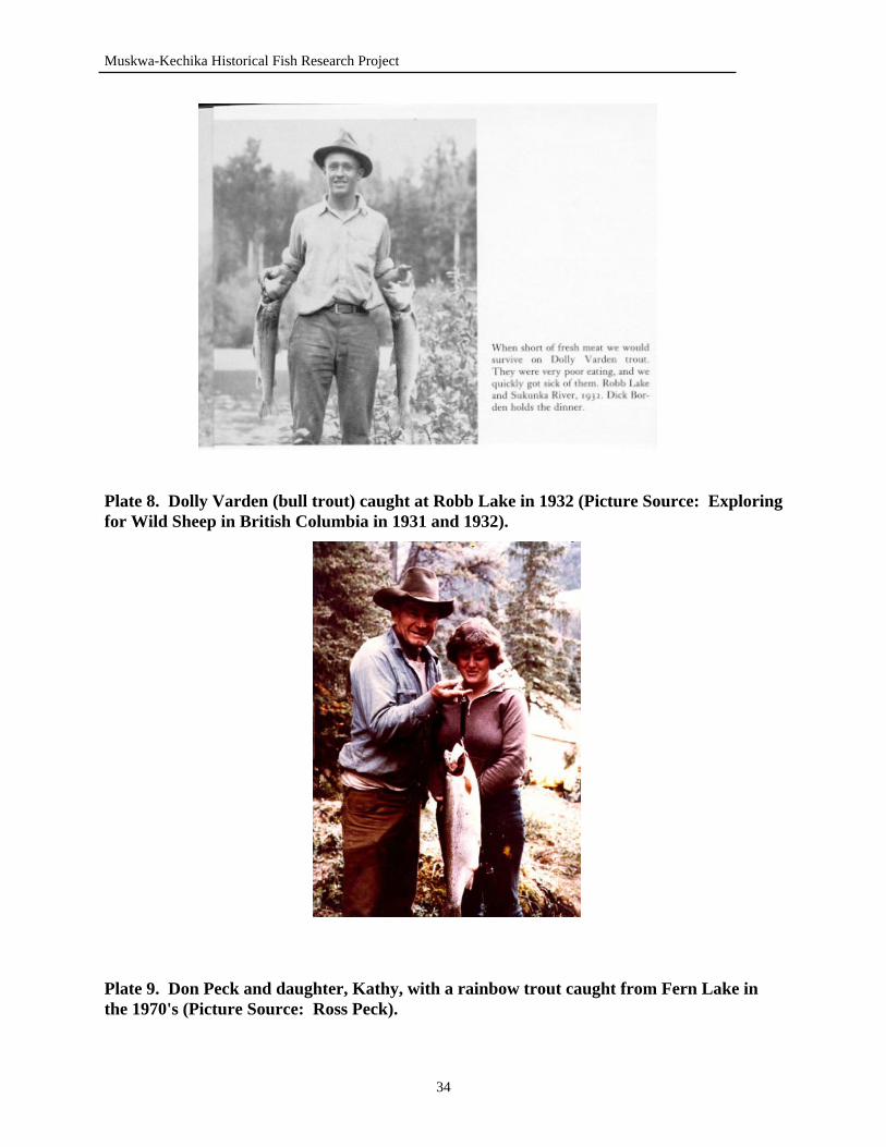
Muskwa-Kechika Historical Fish Research Project
Plate 8. Dolly Varden (bull trout) caught at Robb Lake in 1932 (Picture Source: Exploring for Wild Sheep in British Columbia in 1931 and 1932).
Plate 9. Don Peck and daughter, Kathy, with a rainbow trout caught from Fern Lake in the 1970's (Picture Source: Ross Peck).
34
Muskwa-Kechika Historical Fish Research Project
longer a feasible activity (Palmer, pers. comm.). Palmer (pers. comm.) reported that the rainbow trout populations have not decreased, but the size of fish has. With decreasing amount of fishing activity, Palmer (pers. comm.) hopes the fish will be able to recover from the fishing pressure. Catch and release restrictions have also been imposed on Fern Lake in order to restore the rainbow trout size and populations to more acceptable levels (Peck, pers. comm.). Peck (pers. comm.) reported that the rainbow trout are spawning in the lake, using the gravel of the inlet and outlet creeks. Due to the presence of a set of waterfalls at the outlet of Fern Lake, fish are not able to move upstream into the lake, but movement is permitted downstream. However, Peck (pers. comm.) reported that he does not believe that the rainbow trout are moving downstream into the Muskwa River. The presence of rainbow trout in the Muskwa River, has not been detected, and it is speculated that this is due to the siltyness of the glacial waters in the Muskwa River (Peck, pers. comm.). 7.4 Gathto Creek Gathto Creek is a major tributary to the Muskwa River, that runs for 111 km before it confluence with the Muskwa (MOELP, 1997). Powell (pers. comm.) described the dominant fish species found in Gathto Creek as the bull trout. In small side streams and tributaries to Gathto Creek, bull trout and mountain whitefish could be caught. Pools created in the small side streams provided good habitat for bull trout, and Powell (pers. comm.) remembers catching bull trout up to 75 cm (30 inches) long, out of these pools. The fishing quality of Gathto Creek was dependent on the water levels of the creek (Powell, pers. comm.). Due to consistently changing water levels, pools would come and go depending on the amount of water within the watershed (Powell, pers. comm.). Fishing in Gathto Creek was usually at its best during July, August and early September (Powell, pers. comm.). Powell (pers. comm.) also commented that fishing in the area was not good, due, primarily, to the absence of fish supporting lakes. 7.5 Muskwa River The Muskwa River is one of the largest rivers in the Muskwa-Kechika Management Area, and is the eastern boundary of the management area (MOELP, 1999). Running over 396 km in length, the Muskwa River is a glacier fed river (MOELP, 1997). The river originates at the Kwadacha Wilderness Park and eventually flows into the Fort Nelson River (MOELP, 1997). In the lower portion, the river can be accessed by the Alaska Highway; however, the upper waters of the Muskwa are fairly inaccessible by common modes of transportation (MOELP, 1997). A variety of fish species reside in the murky waters of the Muskwa River: Arctic grayling, bull trout, burbot, chum salmon, and mountain whitefish (MOELP, 2000b). The best fishing locations within the Muskwa River area are those which have slow-running and deep waters (Vince, pers. comm.). Vince (pers. comm.) reported that the most dominant fish species in the area are bull trout and Arctic grayling (See Plates 11 & 14). Mountain whitefish used to be commonly caught in the larger rivers, but now very few are seen (Vince, pers. comm.). When fishing in October, the pools in the Muskwa provided good fishing, and one
35
Muskwa-Kechika Historical Fish Research Project
would be able to catch 8 to 10 fish for dinner (Vince, pers. comm.). Vince (pers. comm.) described the Muskwa River as a difficult river to fish, due to the murky, glacial waters, and during times of extreme cold or dirty waters, growth would not occur at normal rates. Overall, fish populations have decreased in the Muskwa River (Vince, pers. comm.). According to Vince (pers. comm.), populations have decreased because of over-fishing, changes in water-courses due to wash-outs, and the increasing riverboat usage. Crehan Creek, a tributary to the Muskwa River and the source of fish introduced to Grizzly Lake, used to be good fishing, but is no longer (Vince, pers. comm.). Management suggestions include implementing a fishing season, to ensure the area isn’t over-fished, and during the fall season, attention must be focussed on the effects of riverboat use on bull trout populations (Vince, pers. comm.). 8.0 MIDDLE MUSKWA RIVER WATERSHED 8.1 Tuchodi Lakes A pair of lakes, the Tuchodi Lakes are well known to many for the wildlife, fisheries and scenic beauty of the area. The west lake, Upper Tuchodi Lake, is the larger of the two, having a perimeter of 25 km and a surface area of 775 hectares (MOELP, 2000b). The east lake, Lower Tuchodi Lake, is much smaller, having a perimeter of 9.8 km and a surface area of 177 hectares (MOELP, 2000b). Located at 58°13’ - 124°30’, the elevation of the two lakes differs by 30m: Upper Tuchodi Lake, 899 m above sea level, and Lower Tuchodi Lake, 869 m above sea level (MOELP, 2000b). Access to the Tuchodi Lakes is restricted to riverboat, aircraft or horseback (Woods, pers. comm.). Although smaller in size, Lower Tuchodi Lake has a greater diversity of fish species: Arctic grayling, bull trout, lake trout, lake whitefish and mountain whitefish (MOELP, 2000b). Fish species known to be present in Upper Tuchodi Lake include lake trout and lake whitefish (MOELP, 2000b). However abundant in fish species, rainbow trout were introduced into the Lower Tuchodi Lake between 1959 and 1962 by Don Peck, local guide outfitter (Peck, pers. comm.). A Kamloops hatchery was the source of the 10,000 fingerling rainbow trout that were introduced to the lake (Peck, pers. comm.). Record of the stocking can be found on an old guide outfitter cabin wall. The fish were dropped of the end of a airstrip, into the first bay of the lake (Peck, pers. comm.). The rainbow trout introduced to the lake never survived and the Peck family have never caught rainbow trout from the Tuchodi Lakes (Peck, pers. comm.) Soon after the stocking, netting was done in the lake, and no rainbow trout were captured (Peck, pers. comm.). Ross Peck believes that the fish did not survive because of inadequate temperatures. Fishing in the Tuchodi Lake system can be good, depending on the season (Peck, pers. comm.). Peck (pers. comm.) also reported that July is a poor month for fishing, largely due to the high waters in the lake. During early spring, following ice break-up, lake trout fishing can be good.
36
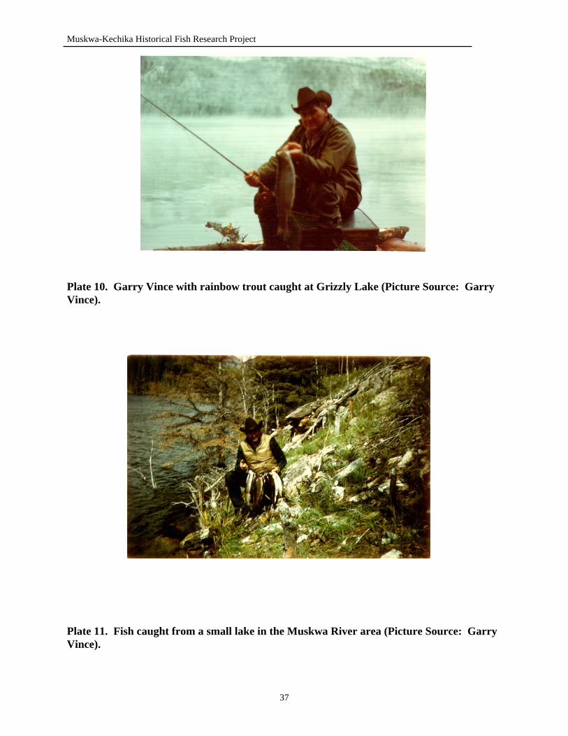
Muskwa-Kechika Historical Fish Research Project
Plate 10. Garry Vince with rainbow trout caught at Grizzly Lake (Picture Source: Garry Vince).
Plate 11. Fish caught from a small lake in the Muskwa River area (Picture Source: Garry Vince).
37
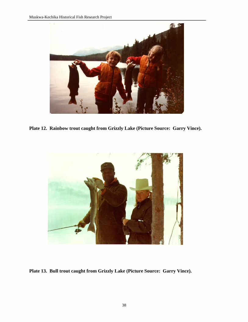
Muskwa-Kechika Historical Fish Research Project
Plate 12. Rainbow trout caught from Grizzly Lake (Picture Source: Garry Vince).
Plate 13. Bull trout caught from Grizzly Lake (Picture Source: Garry Vince).
38
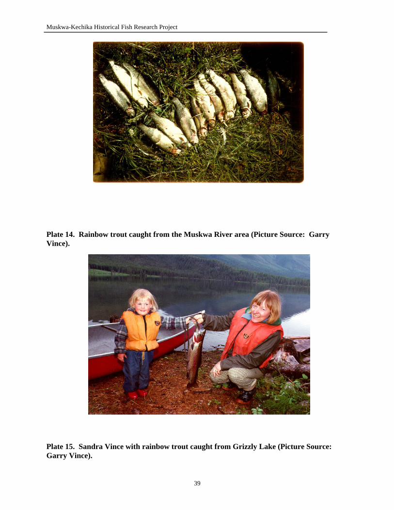
Muskwa-Kechika Historical Fish Research Project
Plate 14. Rainbow trout caught from the Muskwa River area (Picture Source: Garry Vince).
Plate 15. Sandra Vince with rainbow trout caught from Grizzly Lake (Picture Source: Garry Vince).
39
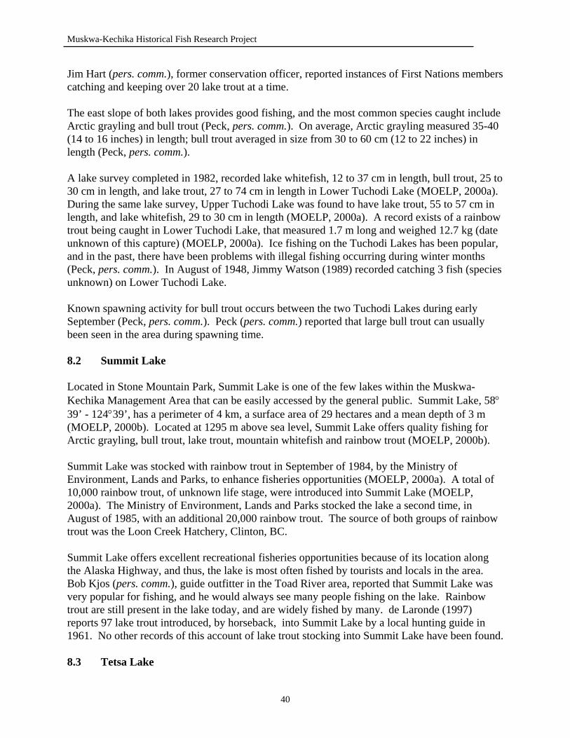
Muskwa-Kechika Historical Fish Research Project
Jim Hart (pers. comm.), former conservation officer, reported instances of First Nations members catching and keeping over 20 lake trout at a time. The east slope of both lakes provides good fishing, and the most common species caught include Arctic grayling and bull trout (Peck, pers. comm.). On average, Arctic grayling measured 35-40 (14 to 16 inches) in length; bull trout averaged in size from 30 to 60 cm (12 to 22 inches) in length (Peck, pers. comm.). A lake survey completed in 1982, recorded lake whitefish, 12 to 37 cm in length, bull trout, 25 to 30 cm in length, and lake trout, 27 to 74 cm in length in Lower Tuchodi Lake (MOELP, 2000a). During the same lake survey, Upper Tuchodi Lake was found to have lake trout, 55 to 57 cm in length, and lake whitefish, 29 to 30 cm in length (MOELP, 2000a). A record exists of a rainbow trout being caught in Lower Tuchodi Lake, that measured 1.7 m long and weighed 12.7 kg (date unknown of this capture) (MOELP, 2000a). Ice fishing on the Tuchodi Lakes has been popular, and in the past, there have been problems with illegal fishing occurring during winter months (Peck, pers. comm.). In August of 1948, Jimmy Watson (1989) recorded catching 3 fish (species unknown) on Lower Tuchodi Lake. Known spawning activity for bull trout occurs between the two Tuchodi Lakes during early September (Peck, pers. comm.). Peck (pers. comm.) reported that large bull trout can usually been seen in the area during spawning time. 8.2 Summit Lake Located in Stone Mountain Park, Summit Lake is one of the few lakes within the Muskwa-Kechika Management Area that can be easily accessed by the general public. Summit Lake, 58°39’ - 124°39’, has a perimeter of 4 km, a surface area of 29 hectares and a mean depth of 3 m (MOELP, 2000b). Located at 1295 m above sea level, Summit Lake offers quality fishing for Arctic grayling, bull trout, lake trout, mountain whitefish and rainbow trout (MOELP, 2000b). Summit Lake was stocked with rainbow trout in September of 1984, by the Ministry of Environment, Lands and Parks, to enhance fisheries opportunities (MOELP, 2000a). A total of 10,000 rainbow trout, of unknown life stage, were introduced into Summit Lake (MOELP, 2000a). The Ministry of Environment, Lands and Parks stocked the lake a second time, in August of 1985, with an additional 20,000 rainbow trout. The source of both groups of rainbow trout was the Loon Creek Hatchery, Clinton, BC. Summit Lake offers excellent recreational fisheries opportunities because of its location along the Alaska Highway, and thus, the lake is most often fished by tourists and locals in the area. Bob Kjos (pers. comm.), guide outfitter in the Toad River area, reported that Summit Lake was very popular for fishing, and he would always see many people fishing on the lake. Rainbow trout are still present in the lake today, and are widely fished by many. de Laronde (1997) reports 97 lake trout introduced, by horseback, into Summit Lake by a local hunting guide in 1961. No other records of this account of lake trout stocking into Summit Lake have been found. 8.3 Tetsa Lake
40
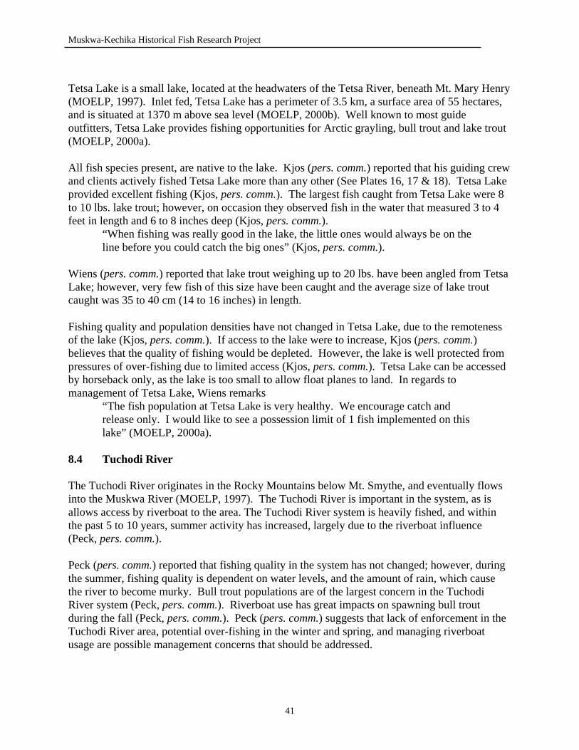
Muskwa-Kechika Historical Fish Research Project
Tetsa Lake is a small lake, located at the headwaters of the Tetsa River, beneath Mt. Mary Henry (MOELP, 1997). Inlet fed, Tetsa Lake has a perimeter of 3.5 km, a surface area of 55 hectares, and is situated at 1370 m above sea level (MOELP, 2000b). Well known to most guide outfitters, Tetsa Lake provides fishing opportunities for Arctic grayling, bull trout and lake trout (MOELP, 2000a). All fish species present, are native to the lake. Kjos (pers. comm.) reported that his guiding crew and clients actively fished Tetsa Lake more than any other (See Plates 16, 17 & 18). Tetsa Lake provided excellent fishing (Kjos, pers. comm.). The largest fish caught from Tetsa Lake were 8 to 10 lbs. lake trout; however, on occasion they observed fish in the water that measured 3 to 4 feet in length and 6 to 8 inches deep (Kjos, pers. comm.). “When fishing was really good in the lake, the little ones would always be on the
line before you could catch the big ones” (Kjos, pers. comm.). Wiens (pers. comm.) reported that lake trout weighing up to 20 lbs. have been angled from Tetsa Lake; however, very few fish of this size have been caught and the average size of lake trout caught was 35 to 40 cm (14 to 16 inches) in length. Fishing quality and population densities have not changed in Tetsa Lake, due to the remoteness of the lake (Kjos, pers. comm.). If access to the lake were to increase, Kjos (pers. comm.) believes that the quality of fishing would be depleted. However, the lake is well protected from pressures of over-fishing due to limited access (Kjos, pers. comm.). Tetsa Lake can be accessed by horseback only, as the lake is too small to allow float planes to land. In regards to management of Tetsa Lake, Wiens remarks
“The fish population at Tetsa Lake is very healthy. We encourage catch and release only. I would like to see a possession limit of 1 fish implemented on this lake” (MOELP, 2000a).
8.4 Tuchodi River The Tuchodi River originates in the Rocky Mountains below Mt. Smythe, and eventually flows into the Muskwa River (MOELP, 1997). The Tuchodi River is important in the system, as is allows access by riverboat to the area. The Tuchodi River system is heavily fished, and within the past 5 to 10 years, summer activity has increased, largely due to the riverboat influence (Peck, pers. comm.). Peck (pers. comm.) reported that fishing quality in the system has not changed; however, during the summer, fishing quality is dependent on water levels, and the amount of rain, which cause the river to become murky. Bull trout populations are of the largest concern in the Tuchodi River system (Peck, pers. comm.). Riverboat use has great impacts on spawning bull trout during the fall (Peck, pers. comm.). Peck (pers. comm.) suggests that lack of enforcement in the Tuchodi River area, potential over-fishing in the winter and spring, and managing riverboat usage are possible management concerns that should be addressed.
41
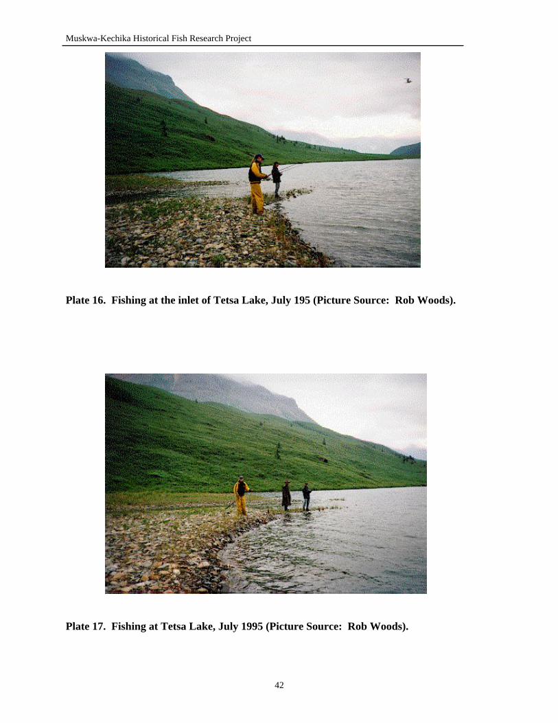
Muskwa-Kechika Historical Fish Research Project
Plate 16. Fishing at the inlet of Tetsa Lake, July 195 (Picture Source: Rob Woods).
Plate 17. Fishing at Tetsa Lake, July 1995 (Picture Source: Rob Woods).
42
Muskwa-Kechika Historical Fish Research Project
The Tuchodi River is important in providing spawning habitat. The Arctic grayling in the Tuchodi River leave the system in the winter, and return in the spring; mountain whitefish are known to remain in the Tuchodi River during the winter season (Peck, pers. comm.). 8.5 Tetsa River Stretching over 87 km, the Tetsa River is one of the primary fishing streams in the Muskwa-Kechika Management Area. The majority of the river flows alongside the Alaska Highway, which provides easy access to fishing opportunities (MOELP, 1997). Davies (1996) provides an excellent description of the Tetsa River: “In the wild hills southwest of the town of Fort Nelson, the main fork of the Tetsa
River flows from four small mountain lakes, drops over a lovely waterfall and rambles north through spruce and pine forest to the Alaska Highway” (p. 29).
Popular for its fishing, the Tetsa River contains a number of fish species, including Arctic grayling, bull trout and mountain whitefish (Wiens, pers. comm.). Wiens (pers. comm.) reported that the majority of the fish population was comprised of bull trout and Arctic grayling, with only a few mountain whitefish present. The fish found in Tetsa River, were uniform in size, ranging from 1 to 2 lbs. (Wiens, pers. comm.). Wiens (pers. comm.) reported that the Tetsa River used to be good fishing, but due to the increasing amount of fishing activity on the lower portion of the river, the fishing quality has declined throughout. Kjos (pers. comm.) guided prior to Dave Wiens in the Toad River area, described the Tetsa River as good fishing, and the river provided many good fishing holes. However, areas of the river that were located along the Alaska Highway, were usually heavily fished (Kjos, pers. comm.). Hart (pers. comm.) reported that the presence of the inconnu, which have moved down, from the Liard River, into the Muskwa and Tetsa Rivers, has created an increase in the fisheries specifically for this species. Arctic grayling populations were dominant in both the Tetsa and Toad River systems, and fishing quality was usually prime during spring months (Kjos, pers. comm.). The Tetsa River provided spawning grounds for many fish species (Kjos, pers. comm.). Kjos (pers. comm.) reported the most common spawning areas within the Tetsa system were the small tributary streams to the river, where the fish could often be seen travelling up the streams. In August of 1930, Mary G. Henry and family fished on the Tetsa River and caught 17 fish, with the average size being 2.5 lbs. (Henry, 1934c). Henry (1934c) described the Tetsa River as
“full of splendid trout” (p. 271). A 6.25 lbs. Dolly Varden (bull trout) was also angled from the Tetsa River by Mary Henry and her crew (Henry, 1934c). Pictures of the bull trout caught are available from the journals of Mary G. Henry, presented in the National Horticultural Magazine, July 1934. Additional accounts of the high quality of fishing in the Tetsa River were discovered in The Living Rivers of British Columbia and Yukon: Volume 2. “Perhaps the Tetsa is the greatest of all the accessible grayling streams in northern
British Columbia” (Davies, 1996, p. 29).
43
Muskwa-Kechika Historical Fish Research Project
Davies (1996) also reports that the best method for fishing the Tetsa River is fly-fishing, and the average size of fish are 40 to 43 cm (16 to 17 inches) in length and 2 lbs. in weight. The Tetsa River is one of a few rivers in the Fort Nelson area that experiences fishing pressure due to their location on the Alaska Highway (Hart, pers. comm.). Hart (pers. comm.), former conservation officer in Fort Nelson, reported seeing outrageous amounts of over-limits of fish, primarily lake trout, taken from the Tetsa River and MacDonald Creek. 8.6 Chischa River and Chlotapecta Creek Known to locals of the area as Sheep Creek, the Chischa River is one of the major contributing streams to the Muskwa River. The river originates below Chischa Peak, near the boundary of the Wokkpash Recreation Area (MOELP, 1997). The river runs for 77 km, until its confluence with the Muskwa River (MEOLP, 2000b). The Chischa River provided good fishing below the set of falls (Kjos, pers. comm.). Chlotapecta Creek, known as 4 Mile Creek to the locals, runs parallel to the Chischa River for 48 km until its confluence with the Muskwa River (MOELP, 2000b). Kjos (pers. comm.) reported that fishing on Chlotapecta Creek was good below the falls. At the confluence of Chlotapecta Creek with the Muskwa River, a pool at the base of a set of waterfalls provided excellent fishing (Kjos, pers. comm.). 9.0 DUNEDIN RIVER WATERSHED 9.1 Dunedin River Very little information was received regarding the Dunedin River. The Dunedin River is located north of the Tetsa River and is a major tributary to the Liard River (MOELP, 1997). Stretching for 201 km, reports exist of the Dunedin River containing primarily Arctic grayling and non-sport fish, such as suckers and sculpins (MOELP, 2000b). Dave Hamilton (pers. comm.), fisheries researcher, reported that the Dunedin River provides excellent fish habitat, but a waterfall at the base of the stream prevents fish from moving up into the river. 10.0 TOAD RIVER WATERSHED 10.1 Wokkpash Lake Located in Wokkpash Recreation Area, Wokkpash Lake has a perimeter of 14.9 km, a surface area of 320 hectares and a mean depth of 22.8 m (MOELP, 2000b). Situated at an elevation of 1172 m above sea level, the lake contains Arctic grayling, bull trout and mountain whitefish (MOELP, 2000b). Wokkpash Lake is accessible by ATV or horseback through a designated trail.
44
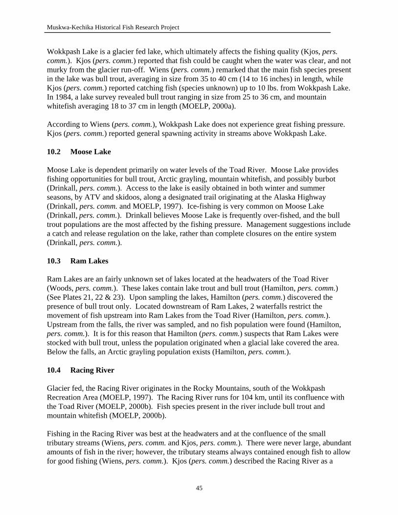
Muskwa-Kechika Historical Fish Research Project
Wokkpash Lake is a glacier fed lake, which ultimately affects the fishing quality (Kjos, pers. comm.). Kjos (pers. comm.) reported that fish could be caught when the water was clear, and not murky from the glacier run-off. Wiens (pers. comm.) remarked that the main fish species present in the lake was bull trout, averaging in size from 35 to 40 cm (14 to 16 inches) in length, while Kjos (pers. comm.) reported catching fish (species unknown) up to 10 lbs. from Wokkpash Lake. In 1984, a lake survey revealed bull trout ranging in size from 25 to 36 cm, and mountain whitefish averaging 18 to 37 cm in length (MOELP, 2000a). According to Wiens (pers. comm.), Wokkpash Lake does not experience great fishing pressure. Kjos (pers. comm.) reported general spawning activity in streams above Wokkpash Lake. 10.2 Moose Lake Moose Lake is dependent primarily on water levels of the Toad River. Moose Lake provides fishing opportunities for bull trout, Arctic grayling, mountain whitefish, and possibly burbot (Drinkall, pers. comm.). Access to the lake is easily obtained in both winter and summer seasons, by ATV and skidoos, along a designated trail originating at the Alaska Highway (Drinkall, pers. comm. and MOELP, 1997). Ice-fishing is very common on Moose Lake (Drinkall, pers. comm.). Drinkall believes Moose Lake is frequently over-fished, and the bull trout populations are the most affected by the fishing pressure. Management suggestions include a catch and release regulation on the lake, rather than complete closures on the entire system (Drinkall, pers. comm.). 10.3 Ram Lakes Ram Lakes are an fairly unknown set of lakes located at the headwaters of the Toad River (Woods, pers. comm.). These lakes contain lake trout and bull trout (Hamilton, pers. comm.) (See Plates 21, 22 & 23). Upon sampling the lakes, Hamilton (pers. comm.) discovered the presence of bull trout only. Located downstream of Ram Lakes, 2 waterfalls restrict the movement of fish upstream into Ram Lakes from the Toad River (Hamilton, pers. comm.). Upstream from the falls, the river was sampled, and no fish population were found (Hamilton, pers. comm.). It is for this reason that Hamilton (pers. comm.) suspects that Ram Lakes were stocked with bull trout, unless the population originated when a glacial lake covered the area. Below the falls, an Arctic grayling population exists (Hamilton, pers. comm.). 10.4 Racing River Glacier fed, the Racing River originates in the Rocky Mountains, south of the Wokkpash Recreation Area (MOELP, 1997). The Racing River runs for 104 km, until its confluence with the Toad River (MOELP, 2000b). Fish species present in the river include bull trout and mountain whitefish (MOELP, 2000b). Fishing in the Racing River was best at the headwaters and at the confluence of the small tributary streams (Wiens, pers. comm. and Kjos, pers. comm.). There were never large, abundant amounts of fish in the river; however, the tributary steams always contained enough fish to allow for good fishing (Wiens, pers. comm.). Kjos (pers. comm.) described the Racing River as a
45
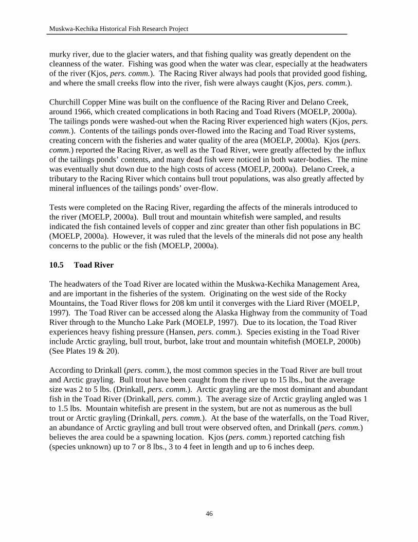
Muskwa-Kechika Historical Fish Research Project
murky river, due to the glacier waters, and that fishing quality was greatly dependent on the cleanness of the water. Fishing was good when the water was clear, especially at the headwaters of the river (Kjos, pers. comm.). The Racing River always had pools that provided good fishing, and where the small creeks flow into the river, fish were always caught (Kjos, pers. comm.). Churchill Copper Mine was built on the confluence of the Racing River and Delano Creek, around 1966, which created complications in both Racing and Toad Rivers (MOELP, 2000a). The tailings ponds were washed-out when the Racing River experienced high waters (Kjos, pers. comm.). Contents of the tailings ponds over-flowed into the Racing and Toad River systems, creating concern with the fisheries and water quality of the area (MOELP, 2000a). Kjos (pers. comm.) reported the Racing River, as well as the Toad River, were greatly affected by the influx of the tailings ponds’ contents, and many dead fish were noticed in both water-bodies. The mine was eventually shut down due to the high costs of access (MOELP, 2000a). Delano Creek, a tributary to the Racing River which contains bull trout populations, was also greatly affected by mineral influences of the tailings ponds’ over-flow. Tests were completed on the Racing River, regarding the affects of the minerals introduced to the river (MOELP, 2000a). Bull trout and mountain whitefish were sampled, and results indicated the fish contained levels of copper and zinc greater than other fish populations in BC (MOELP, 2000a). However, it was ruled that the levels of the minerals did not pose any health concerns to the public or the fish (MOELP, 2000a). 10.5 Toad River The headwaters of the Toad River are located within the Muskwa-Kechika Management Area, and are important in the fisheries of the system. Originating on the west side of the Rocky Mountains, the Toad River flows for 208 km until it converges with the Liard River (MOELP, 1997). The Toad River can be accessed along the Alaska Highway from the community of Toad River through to the Muncho Lake Park (MOELP, 1997). Due to its location, the Toad River experiences heavy fishing pressure (Hansen, pers. comm.). Species existing in the Toad River include Arctic grayling, bull trout, burbot, lake trout and mountain whitefish (MOELP, 2000b) (See Plates 19 & 20). According to Drinkall (pers. comm.), the most common species in the Toad River are bull trout and Arctic grayling. Bull trout have been caught from the river up to 15 lbs., but the average size was 2 to 5 lbs. (Drinkall, pers. comm.). Arctic grayling are the most dominant and abundant fish in the Toad River (Drinkall, pers. comm.). The average size of Arctic grayling angled was 1 to 1.5 lbs. Mountain whitefish are present in the system, but are not as numerous as the bull trout or Arctic grayling (Drinkall, pers. comm.). At the base of the waterfalls, on the Toad River, an abundance of Arctic grayling and bull trout were observed often, and Drinkall (pers. comm.) believes the area could be a spawning location. Kjos (pers. comm.) reported catching fish (species unknown) up to 7 or 8 lbs., 3 to 4 feet in length and up to 6 inches deep.
46
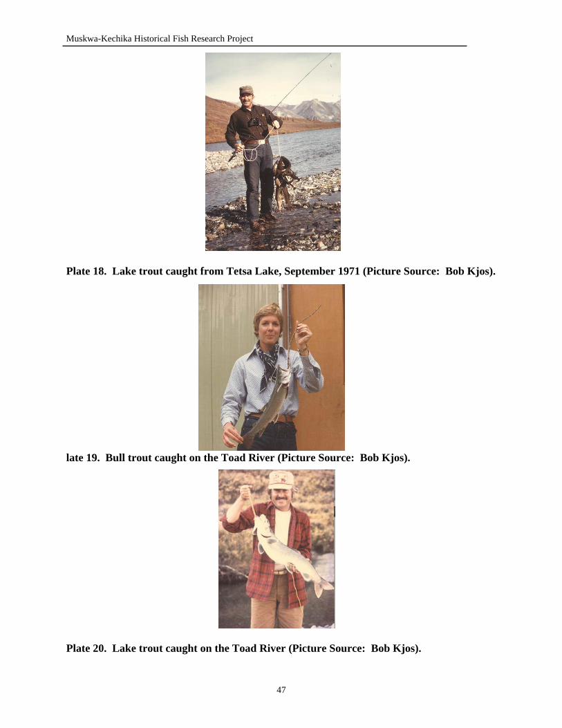
Muskwa-Kechika Historical Fish Research Project
Plate 18. Lake trout caught from Tetsa Lake, September 1971 (Picture Source: Bob Kjos).
late 19. Bull trout caught on the Toad River (Picture Source: Bob Kjos).
Plate 20. Lake trout caught on the Toad River (Picture Source: Bob Kjos).
47
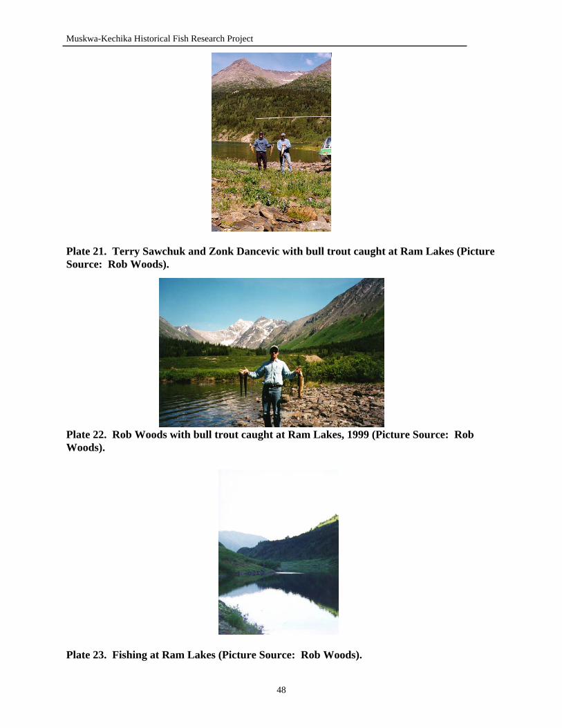
Muskwa-Kechika Historical Fish Research Project
Plate 21. Terry Sawchuk and Zonk Dancevic with bull trout caught at Ram Lakes (Picture Source: Rob Woods).
Plate 22. Rob Woods with bull trout caught at Ram Lakes, 1999 (Picture Source: Rob Woods).
Plate 23. Fishing at Ram Lakes (Picture Source: Rob Woods).
48
Muskwa-Kechika Historical Fish Research Project
Davies (1996) reports the average size of Arctic grayling are 30 to 40 cm (12 to 16 inches) in length. “The Toad River has a big, prolific population of Arctic grayling” (Davies, 1996,
p. 183). Wiens (pers. comm.) reported that fish populations have been decreasing on the Toad River and is unsure whether this population change is due to increased fishing pressure, or constantly changing water levels, such as flooding, that occur on the Toad River. 10.6 MacDonald Creek MacDonald Creek experiences a greater amount of fishing pressure due to its location along major access routes (Hamilton, pers. comm.). MacDonald Creek runs along the Alaska Highway and along the designated trail routes into Stone Mountain Park (MOELP, 1997). This direct access to the stream creates additional fishing pressure for MacDonald Creek (Hansen, pers. comm.). In the past few years, Myles Thorpe (pers. comm.) has noticed the Arctic grayling angled are becoming larger in size in MacDonald Creek and near Wokkpash Lake. 11.0 LIARD RIVER WATERSHED 11.1 Muncho Lake Muncho Lake is one of the only accessible lakes, with decent fishing opportunities, within the Muskwa-Kechika Management Area (Hansen, pers. comm.). Located within Muncho Lake Park, the Alaska Highway travels along the complete length of the lake. Having a perimeter of 67 km, a surface area of 1489 hectares, a mean depth of 52 m and at an elevation of 817 m above sea level, Muncho Lake provides quality fishing in an accessible setting (MOELP, 2000b). Fish species present in Muncho Lake include Arctic grayling, bull trout, burbot, lake trout, mountain whitefish and rainbow trout (MOELP, 2000b). Rainbow trout populations are not native to Muncho Lake (de Laronde, 1997). Muncho Lake was stocked with rainbow trout by the Ministry of Environment, Lands and Parks (MOELP, 2000a). Both introductions occurred in June of 1989, with the initial stocking introducing 10,000 fry rainbow trout to Muncho Lake from a Fraser Valley Hatchery (MOELP, 2000a). The second stocking brought in an additional 10,000 yearling rainbow trout to the lake (MOELP, 2000a). Both incidents of stocking were completed by the Ministry of Environment, Lands and Parks to create and promote a recreational fishery at Muncho Lake (de Laronde, 1997). The rainbow trout population lasted for approximately 4 years. Hansen (pers. comm.) reported that the last rainbow trout to come out of Muncho Lake, to his knowledge, was in 1993. Prior to 1993 the average size of rainbow trout that were being caught were 24 to 26 inches in length and 3 to 4 lbs. in weight (Hansen, pers. comm.). Since 1993, the fishing for rainbow trout has not proved to be successful (Hansen, pers. comm.). In 1992, a lake survey was conducted and revealed no rainbow trout caught during the survey (MOELP, 2000a).
49
Muskwa-Kechika Historical Fish Research Project
Muncho Lake is known to be the source of many large lake trout angled from the area. The record book lake trout for Muncho Lake is a 45 lbs. fish caught in 1985, by Dan Belfour of Fort Nelson, BC (Hansen, pers. comm.). Records suggest a 52 lbs. fish (species unknown) was angled from Muncho Lake, in 1942, during the construction of the Alaska Highway (MOELP, 2000a). Recently, Don Beattie (pers. comm.) reported that a 42 lbs. lake trout, measuring 8 inches deep, was caught from Muncho Lake in the spring of 2000. Immediate access to Muncho Lake has created problems with illegal fishing (Hansen, pers. comm.). Throughout the 1990’s, several groups from Fort Nelson were using set lines to catch burbot, which was permitted at the time. However, when lake trout were caught in the set lines, they were not being released (Hansen, pers. comm.). Since then, regulations have been changed to restrict the use of all set lines in Muncho Lake, and following the change, the amount of illegal fishing has decreased (Hansen, pers. comm.). Muncho Lake is an unproductive lake, and is not able to sustain a high amount of fishing pressure and on several occasions, people would come out of the lake with 30 to 40 fish from one weekend of fishing (Hansen, pers. comm.). Muncho Lake was unable to support this degree of fishing pressure. Fish populations have declined in the past 2 years, resulting in the fishing success rate decreasing by 80 percent (Hansen, pers. comm.). From 1990 to 1996, it was easy for anyone, experienced or not, to catch fish in Muncho Lake; however, even the experienced anglers, who have fished the lake for many years, cannot be successful (Hansen, pers. comm.). 11.2 Grizzly Lake Many small, pothole lakes in the Liard River Watershed have been stocked by local people in the area (Hansen, pers. comm.). Al Hansen (pers. comm.) reported that he knew of a lake called Grizzly Lake, a small pothole lake, located on the West Toad River, which was stocked with bull trout and Arctic grayling. The Arctic grayling and bull trout were angled on the West Toad River and brought up to Grizzly Lake (Hansen, pers. comm.) According to Hansen (pers. comm.) fish are naturally restricted from entering the lake. The lake was stocked 25 to 30 years ago, however, it is not known who transplanted the fish into the lake (Hansen, pers. comm.). 11.3 Unnamed Lake #2 Bob Kjos (pers. comm.) knew of a lake, name unknown, that was stocked by Red Saurenson. The lake is located off Otelsas Creek, a tributary to the Toad River, which lies south of the Muncho Lake Park (Kjos, pers. comm.). The lake is landlocked and stretches only one quarter of a mile in length (Kjos, pers. comm.). This lake was believed to be stocked in the late 1970’s; however, it is not known what species was transplanted to the lake or whether the introductions were successful (Kjos, pers. comm.). 11.4 Long Mountain Lake Long Mountain Lake is located north of Long Mountain and east of the Vents River (MOELP, 1997). Long Mountain Lake, 59°18’ - 126°38’, has a perimeter of 8 km, a surface area of 120 hectares and a mean depth of 9 m (MOELP, 2000b). Situated at an elevation of 915 m above sea
50
Muskwa-Kechika Historical Fish Research Project
level, Long Mountain Lake contains Arctic grayling, bull trout and lake trout fish species (MOELP, 2000b). Long Mountain Lake empties into Long Mountain Creek which is a tributary to the Vents River (MOELP, 1997). In 1985, a lake survey conducted on Long Mountain Lake revealed lake trout 16 to 87 cm in length and Arctic grayling 22 to 39 cm in length (MOELP, 2000a). Urs Schildknecht, angling guide, has submitted records of lake trout being angled from Long Mountain Lake, which measured, on average, to be 38 to 63 cm (15 to 25 inches) in length and 2 to 3.5 lbs. in weight (MOELP, 2000a). In 1989, Schildknecht reported a 36 inch lake trout, weighing 18 lbs. being caught from the lake (MOELP, 2000a). Arctic grayling caught in Long Mountain Lake averaged 1.5 to 2.5 lbs. in weight (MOELP, 2000a). Long Mountain Lake receives a moderate amount of fishing pressure from “fly-in fishing.” The majority of this fishing pressure is directly related to the commercial fishing operation, located in Muncho Lake, BC, which encompasses 12 large lakes within the northwestern portion of the Muskwa-Kechika Management Area, from the Racing River to the Turnagain River. 11.5 Fishing Lake Fishing Lake, 59°28’ - 126°38’, is a popular lake that is well known for its lake trout and northern pike fishery. It is located south of the Liard River, and drains into the Vents River (MOELP, 1997). Fishing Lake measures an 18.4 km perimeter, 120 hectare surface area and a mean depth of 20 m (MOELP, 2000b). Access to Fishing Lake is limited to aircraft or horseback (Woods, pers. comm.). Fish species present in Fishing Lake include burbot, lake trout, lake whitefish and northern pike (MOELP, 2000b). Fishing Lake experiences a moderate amount of fishing pressure from the commercial fishing operation. The fish species most sought after in Fishing Lake are lake trout and northern pike (MOELP, pers. comm.). Schildknecht has recorded northern pike ranging in size from 50 to 90 cm (20 to 36 inches) in length and 4 to 10 lbs. in weight (MOELP, 2000a). Lake trout angled are known to be 60 to 70 cm (25 to 28 inches) in length and weigh up to 10 lbs. (MOELP, 2000a). Rearing and spawning habitat is available in the Fishing Creek outlet and inlet (MOELP, 2000a). The outlet has been observed as rearing habitat, and the inlet is known to be used for spawning and rearing of northern pike (MOELP, 2000a). Schildknecht (pers. comm.) reported that Fishing Lake is currently under excessive fishing pressure by 3 groups that fish the lake. Schildknecht (pers. comm.) suggests that Fishing Lake will not be able to sustain this degree of fishing pressure and that regulations should be installed to prevent the over-fishing of lake trout and northern pike populations. 11.6 Lapie Lake
51
Muskwa-Kechika Historical Fish Research Project
A small amount of information was discovered for this small lake located east of Long Mountain Lake, on the headwaters of Lapie Creek (MOELP, 1997). Lapie Lake, 59°18’ - 126°17’, has a perimeter of 3.1 km and a surface area of 20 hectares (MOELP, 2000b). The known fish species within the lake include lake trout and northern pike, and bull trout have been observed in Lapie Creek (MOELP, 2000a). Records exist of northern pike angled out of Lapie Lake which range in size from 30 to 50 cm (12 to 20 inches) in length and 2 to 3 lbs. in weight (MOELP, 2000a). 11.7 Liard River The Liard River is one of the largest rivers found within the Muskwa-Kechika Management Area. The Liard River originates in the Yukon Territory and travels 506 km, until its confluence with the Mackenzie River (MOELP, 2000b). The Liard River is unique to the MKMA and the province of British Columbia due to its vast diversity of fish species. Fish species known to exist in the Liard River include Arctic grayling, bull trout, mountain whitefish, northern pike, Arctic cisco, burbot, chinook salmon, goldeye, inconnu, lake whitefish, round whitefish and walleye. The Arctic cisco, chinook salmon and goldeye are not common fish to BC, and are therefore often regarded as “species at risk” within BC (Hamilton, pers. comm.). However, species such as goldeye and Arctic cisco, although not common in BC, are widely populated through northern Alberta and the Northwest Territories. It is believed that the Arctic cisco and chinook salmon, being Arctic watershed fish, have moved down through the Mackenzie River and have migrated into the Liard River (Hamilton, pers. comm.). In December of 1979, a chinook salmon was caught on the Liard River, at Kilometer 327, measuring 67 cm in length and 3 kg in weight (MOELP, 2000a). The fish that are in highest abundance in the Liard River include mountain whitefish, Arctic grayling, bull trout and walleye (Hamilton, pers. comm.). Northern pike are more common in lakes than in rivers, however, a few have been caught in the Liard River (MOELP, 2000a). Arctic grayling are the most popular sport fish in the Liard River system. Small tributary streams of the Liard can often be observed containing large congregations of Arctic grayling during the spring (MOELP, 2000b). These small tributaries also provide important spawning and rearing habitat for bull trout within the Liard River system (MOELP, 2000b). Other streams located in the Liard River Watershed include the Trout River, and Vents River. The Trout River originates from the outlet of Muncho Lake, travels 84 km and flows into the Liard River (MOELP, 2000b). Fish species present in the Trout River include Arctic grayling, bull trout and mountain whitefish (MOELP, 2000b). The Vents River and its tributaries experience a greater degree of fishing pressure than other streams encounter (Hansen, pers. comm.). Information on these rivers and streams is lacking, however, this does not imply the lack of fishery or fishery potential in them. Arctic grayling are the most predominant sport fish present in the streams and rivers in the Liard River Watershed and in the northwest portion of the MKMA (Hamilton, pers. comm.). The Arctic grayling spawn during the spring, and according to Hamilton (pers. comm.) the streams and rivers which are tributaries to the Liard River offer plentiful, spawning and rearing habitat
52
Muskwa-Kechika Historical Fish Research Project
for this popular sport fish. However, many of the river and stream systems are restricted by barriers, such as waterfalls, which prevent the movement and distribution of fish throughout the system (Hamilton, pers. comm.). 12.0 COAL RIVER WATERSHED 12.1 Netson Lake Netson Lake is located on the headwaters of Netson Creek, which is a major tributary to the Rabbit River (MOELP, 1997). A fairly large lake, Netson Lake has a perimeter of 20.5 km, a surface area of 288 hectares and a mean depth of 7.7 m (MOELP, 2000b). This remote lake is only accessible by aircraft and horseback (Cooke, pers. comm.). Fish species present in the lake include Arctic grayling, bull trout, mountain whitefish, round whitefish, lake trout and northern pike (MOELP, 2000a). Frank Cooke (pers. comm.), former guide outfitter in the Kechika River area, reported that Netson Lake has produced large northern pike up to 3 to 4 feet in length. Located in the lower portion of the Kechika River valley, Cooke (pers. comm.) described Netson Lake as a shallow lake. Many of the other lakes located in the lower Kechika valley are shallow and usually have good northern pike populations (Cooke, pers. comm.). A lake survey completed in 1975 reported the presence of Arctic grayling, bull trout, general whitefish and lake trout in Netson Lake (MOELP, 2000a). In 1983, the Arctic grayling were found to be 24 to 36 cm in length; lake trout from 13 to 64 cm; round whitefish ranging from 13 to 29 cm; mountain whitefish measuring 19 to 27 cm (MOELP, 2000a). Schildknecht has recorded bull trout, Arctic grayling and lake trout angled from Netson Lake. In 1989, Arctic grayling angled measured to be 48 cm (19 inches) in length, and a lake trout caught measured 24 inches and 6 lbs. (MOELP, 2000a). On average, bull trout angled by Schildknecht weighed from 1 to 3 lbs. (MOELP, 2000a). 13.0 LOWER KECHIKA RIVER WATERSHED 13.1 Birches Lake Birches Lake, 59°11’ - 127°45’, is located on the west side of the Kechika River, on Davie Creek (MOELP, 1997). Birches Lake has a perimeter of 8.9 km, a surface area of 301 hectares and a mean depth of 14.5 m (MOELP, 2000b). Situated at 658 m above sea level, Birches Lake contains burbot, lake trout and northern pike. In 1982, a lake survey found northern pike that measured 14 to 77 cm in length and lake trout from 44 to 49 cm in length (MOELP, 2000a). Although no observations of direct spawning activity, the outlet creek provides potential spawning and rearing habitat for northern pike, and possible spawning habitat for burbot (MOELP, 2000a).
53
Muskwa-Kechika Historical Fish Research Project
13.2 Twin Island Lake Twin Island Lake is the second of 3 lakes located on Davie Creek. Located at 59°15’ - 127°50’, Twin Island Lake has a perimeter of 10.6 km, a surface area of 167 hectares and a mean depth of 12.3 m (MOELP, 2000b). Twin Island Lake lies at an elevation of 710 m above sea level on the west side of the Kechika River. The only fish species present in Twin Island Lake is northern pike (MOELP, 2000a). A lake survey conducted in 1982, revealed northern pike ranging in size from 37 to 69 cm in length (MOELP, 2000a). One of the inlets to the lake was observed to be used as a nursery for juvenile northern pike (MOELP, 2000a). 13.3 Solitary Lake Located near the western boundary of the Muskwa-Kechika Management Area, Solitary Lake drains into the Deadwood River (MOELP, 1997). Solitary Lake, 59°15’ - 128°11’, has a perimeter of 12.7 km, a surface area of 511 hectares and a mean depth of 5.8 m (MOELP, 2000b). The fish species known to occur in Solitary Lake include burbot, lake trout and northern pike (MOELP, 2000a). Lake trout sampled from Solitary Lake ranged in size from 27 to 56 cm in length, and northern pike measured 42 to 75 cm in length (MOELP, 2000a). The unnamed outlet of Solitary Lake, which drains into the Deadwood River, was observed to contain juvenile northern pike (MOELP, 2000a). Kirby Funnel, former guide outfitter in the Deadwood River area, reported catching northern pike from 75 to 78 cm (30 to 31 inches) in length, and lake trout averaging 60 cm (24 inches) in length (MOELP, 2000a). 13.4 Aeroplane Lake South of the Red River, Aeroplane Lake, 59°22’ - 127°53’, is located at the headwaters of Davie Creek, west of the Kechika River (MOELP, 1997). A fairly large lake, Aeroplane Lake has a perimeter of 14.2 km, a surface area of 471 hectares and a mean depth of 11.2 m (MOELP, 2000b). At an elevation of 702 m, Aeroplane Lake contains lake trout, burbot and northern pike (MOELP, 2000a). Northern pike were found to range in size from 44 to 76 cm in length, during a lake survey conducted in 1982 (MOELP, 2000a). In 1991, lake trout sampled, were found to be 48 to 80 cm in length in Aeroplane Lake (MOELP, 2000a). In 1989, Schildknecht has reported northern pike angled from Aeroplane Lake ranging in size from 52 to 88 cm (21 to 35 inches) in length and weighing up to 22 lbs. (MOELP, 2000a). Lake trout caught from Aeroplane Lake, by Schildknecht, were reported to measure 45 to 63 cm (18 to 25 inches) and weigh 3 to 8 lbs. (MOELP, 2000a). Urs Schildknecht (pers. comm.), commercial fishing operator, reported that northern pike populations have decreased in Aeroplane Lake in the past 15 years. More than 20 large northern pike used to be angled from Aeroplane Lake; however, Schildknecht (pers. comm.) described that the fishing has become inconsistent and much more difficult to catch large pike. Schildknecht (pers. comm.) believes the fishing quality has decreased due to mining exploration that has occurred near Aeroplane Lake, having a direct affect on the northern pike populations.
54
Muskwa-Kechika Historical Fish Research Project
13.5 Kechika River The Kechika River is a major river system in the Muskwa-Kechika Management Area, which contains a diverse variety of fish species. Originating outside of the MKMA, west of the South Gataga River, the Kechika River travels for 351 km until its confluence with the Liard River (MOELP, 2000b). Many rivers and streams flow into the Kechika, which provides the large diversity of fish species present (Cooke, pers. comm.). Fish species present in the Kechika River include Arctic grayling, bull trout, burbot, lake whitefish, mountain whitefish, round whitefish and northern pike (MOELP, 2000b). Frank Cooke (pers. comm.) described the Kechika River as a poor fishing river due to the influx of glacial water at the headwaters of the river. The prime locations for fishing the Kechika River are where the tributary streams and rivers flow into the river (Cooke, pers. comm.). Cooke (pers. comm.) reported that large Arctic grayling can be caught in the Kechika River. The average size of Arctic grayling angled were 45 cm (18 inches) in length (Cooke, pers. comm.). Due to the glacial water influence, the best time of year to fish the Kechika River was during the fall when the water was clear (Cooke, pers. comm.). 14.0 UPPER KECHIKA RIVER WATERSHED 14.1 Graveyard Lake Graveyard Lake, 59°16’ - 127°22’, is located on Boya Creek, a tributary to the Kechika River (MOELP, 1997). Located at an elevation of 643 m above sea level, the lake has a perimeter of 12.9 km (MOELP, 2000b). Very little is known regarding the fisheries of Graveyard Lake. Fish species known to occur in the lake, through observations, include lake trout and lake whitefish (MOELP, 2000b). 14.2 Horneline Lake Horneline Lake, 59°05’ - 127°06’, is located at the headwaters of Horneline Creek, at an elevation of 853 m above sea level (MOELP, 2000b). The lake has a perimeter of 10.9 km, a surface area of 202 hectares and a mean depth of 5 m (MOELP, 2000b). Species known to occur in Horneline Lake include lake trout, mountain whitefish and northern pike (MOELP, 2000b). During a 1983 lake survey, lake trout and mountain whitefish were sampled; fish sampled measured 34 to greater than 80 cm for lake trout, and 18 to 34 cm for mountain whitefish (MOELP, 2000a). The outlet creek, Horneline Creek, was observed to be used for mountain whitefish spawning activity (MOELP, 2000a). 14.3 Moose (Pup) Lake Moose Lake, also known as Pup Lake, is located west of Horneline Lake, at 59°04’ - 127°14’. Situated at an elevation of 945 m, Pup Lake has a perimeter of 10.2 km, a surface area of 185 hectares and a mean depth of 16.1 m (MOELP, 2000b). Lake trout, mountain whitefish and
55
Muskwa-Kechika Historical Fish Research Project
northern pike are known to exist in Pup Lake (MOELP, 2000b). A lake survey completed in 1983 discovered lake trout ranging in size from 35 to 68 cm in length, and mountain whitefish measuring 27 to 38 cm in length (MOELP, 2000a). The primary outlet of Pup Lake was observed to contain numerous chub, suckers and small whitefish (MOELP, 2000a). The major inlet to the lake provided a spawning location for the mountain whitefish. 14.4 Scoop Lake Scoop Lake is located on the Kechika River, 59°01’ - 127°25’, at an elevation of 616 m above sea level (MOELP, 2000b). Known primarily for its northern pike fishery, Scoop Lake is also known to contain bull trout, lake trout, mountain whitefish and rainbow trout (MOELP, 2000b). However, information received from Frank Cooke (pers. comm.) contradicts this information, stating that the only fish species present in Scoop Lake are northern pike. In 1982, a lake survey conducted revealed the presence of mountain whitefish and northern pike (MOELP, 2000a). Cooke (pers. comm.) also reported that the fishing pressure on Scoop Lake has not changed dramatically in the past number of years. 14.5 Denetiah Lake Denetiah Lake is the most popular sport fishing lake in the northwest portion of the Muskwa-Kechika Management Area. It is readily fished by guide outfitters, commercial fishing operations and those who have access to the lake. Located on Denetiah Creek, a tributary to the Kechika River, Denetiah Lake is most well known for its rainbow trout populations (MOELP, 1997). Situated at an elevation of 997 m above sea level, Denetiah Lake has a perimeter of 25.3 km, a surface area of 902 hectares and a mean depth of 33.1 m (MOELP, 2000b). The only sport fish this lake contains is rainbow trout. A lake naturally barren, the rainbow trout populations were introduced to Denetiah Lake (Bradford, pers. comm.). In 1958, Denetiah Lake was stocked with 25 rainbow trout, which were angled from Tucho Lake and Gnat Lake, on barbless hooks (Bradford, pers. comm. and Dalziel, pers. comm.). George Dalziel, former guide outfitter in the Dease Lake area, brought the fish into Denetiah Lake in wash tubs by plane (Bradford, pers. comm.). Bradford (pers. comm.) reported that the rainbow trout introduced to the lake averaged in size from 8 to 10 inches in length. Due to external parasites found on the rainbow trout populations in Rainbow Lakes, fish transplanted were taken from Tucho Lake and Gnat Lake, which were absent of these external parasites (Dalziel, pers. comm.). Denetiah Lake was the first lake to be stocked by George Dalziel (Dalziel, pers. comm.). When the rainbow trout were transplanted into Denetiah Lake is unclear, and many different dates were obtained by a number of information sources. Cooke (pers. comm.) reported that the fish were introduced in 1946, and the source of the fish was Rainbow Lakes. Sherry Bradford (pers. comm.) reported the date of transplant to be 1958, and Byron Dalziel (pers. comm.) believed the date to be in the period between 1963 to 1965. Since, the introduction of rainbow trout, Denetiah Lake has become one of the most popular fishing locations in the north. Cooke (pers. comm.) reported that the average size of rainbow
56
Muskwa-Kechika Historical Fish Research Project
trout caught was 4 to 5 lbs. Jack Baker (pers. comm.), former pilot, reported fishing in Denetiah Lake and catching rainbow trout from 5 to 6 lbs., approximately 40 years ago. More recently, Darwin Cary, guide outfitter in the Kechika River area, has reported catching 30 to 43 cm (12 to 17 inch) rainbow trout from Denetiah Lake (MOELP, 2000a). Fishing is known to be best during the spring months at the inlet and outlet creek mouths (MOELP, 2000a). Cooke (pers. comm.) reported that rainbow trout populations in Denetiah Lake have decreased in the past 20 years. In addition to decreasing populations, the size of fish angled from Denetiah Lake have also decreased (Cooke, pers. comm.). Cooke (pers. comm.) believes that the decreasing size of rainbow trout is due to the excessive amount of fishing activity on the lake. In June of 1987, a greatly reduced rainbow trout size was reported. In years previous to 1987, the average size of fish was 2 to 3 lbs., and known to produce fish weighing 8 to 10 lbs. (MOELP, 2000a). However, in 1987, the average size was only 1 to 1.5 lbs. (MOELP, 2000a). Spawning activity in Denetiah Lake was observed on many occasions (Dalziel, pers. comm.). Dalziel (pers. comm.) reported that spawning locations were primarily the inlet and outlet creeks of Denetiah Lake, and spawning activity usually occurred in May and June, when ice break-up would begin. A lake survey conducted in 1983, observed the Denetiah Creek outlet as rearing, and possible spawning, habitat for rainbow trout (MOELP, 2000a). 14.6 Moodie Lakes Located on Moodie Creek, a tributary to the Kechika River, the second of the two Moodie Lakes, 58°49’ - 127°37’, contains a variety of fish species (MOELP, 2000a). The second Moodie Lake, the larger of the 2 lakes, has a perimeter of 5.2 km, a surface area of 90 hectares and a mean depth of 7.7 m (MOELP, 2000b). Situated at an elevation of 942 m, the second Moodie Lake contains bull trout, lake trout and mountain whitefish (MOELP, 2000a). A lake survey conducted in 1982 revealed lake trout ranging in size from 44 to 64 cm in length and bull trout averaging 60 cm in length (MOELP, 2000a). Mountain whitefish were also sampled and the average size was found to be 40 cm in length (MOELP, 2000a). An inlet to the lake provides a possible spawning location for mountain whitefish and bull trout, however, no spawning activity was observed (MOELP, 2000a). 15.0 TURNAGAIN RIVER WATERSHED 15.1 Dall Lake Located on the Dall River, Dall Lake, 58°35’ - 127°38’, is part of the Turnagain River system (MOELP, 1997). A large lake, Dall Lake has a perimeter of 44.6 km, a surface area of 1813 hectares and a mean depth of 9.7 m (MOELP, 2000b). A variety of fish species are present in
57
Muskwa-Kechika Historical Fish Research Project
the lake, including Arctic grayling, bull trout, lake trout, lake whitefish, northern pike and round whitefish (MOELP, 2000b). Located at an elevation of 782 m above sea level, Dall Lake is only accessible by aircraft and horseback (MOELP, 1997). With the diversity of fish present in Dall Lake and float plane access, Dall Lake is well known and has been fished on numerous occasions. Cooke (pers. comm.) described Dall Lake as a deep, cold lake that stretches 10 miles long and is well known for its large lake trout and northern pike populations. Byron Dalziel (pers. comm.), former guide outfitter in the area, reported that Dall Lake was a popular lake for lake trout fishing, and Hart (pers. comm.) stated that the lake contains large sized lake trout. Darwin Cary has reported bull trout angled from Dall Lake, measuring 14 to 15 inches in length (MOELP, 2000a). In 1983, a lake survey conducted on Dall Lake found Arctic grayling, lake trout, bull trout, lake whitefish, round whitefish and northern pike (MOELP, 2000a). Arctic grayling, found primarily at the outlet of the lake, ranged in size from 30 to 35 cm; lake trout sampled measured to be 34 to 63 cm in length; bull trout were found up to 40 cm (MOELP, 2000a). 15.2 Rainbow Lakes Rainbow Lakes are a pair of lakes located on Kutcho Creek (MOELP, 1997). Only one of the pair of lakes is located within the Muskwa-Kechika Management Area. The boundary for the management area runs between the two lakes, include the north lake and excluding the south lake (MOELP, 1999). Approximately the same size, the two lakes also do not differ in species composition (MOELP, 2000b). The north Rainbow Lake, 58°27’ - 128°22’, has a perimeter of 13 km, a surface area of 270 hectares and a mean depth of 15.6 m; the south Rainbow Lake, 58°23’ - 128°29’, has a perimeter of 14.9 km, a surface area of 258 hectares and a mean depth of 12.5 m (MOELP, 2000b). Rainbow Lakes are located at approximately 1150 m above sea level, and are known to contain bull trout, mountain whitefish and rainbow trout (MOELP, 2000b). Bradford (pers. comm.) reported that the rainbow trout population in Rainbow Lakes is natural and the lakes were never stocked (See Plates 24 & 25). Myles Bradford, guide outfitter in the Dease Lake area, reported catching rainbow trout and bull trout in Rainbow Lakes (MOELP, 2000a). Lake surveys completed in 1980 reported the presence of rainbow trout, bull trout and mountain whitefish in both the north and south lakes (MOELP, 2000a). The size range of fish species was fairly uniform between the two lakes, showing no great differences: rainbow trout measured 21 to 50 cm, bull trout were found to be 25 to 53 cm in length, and mountain whitefish ranged in size from 13 to 43 cm (MOELP, 2000a).
58
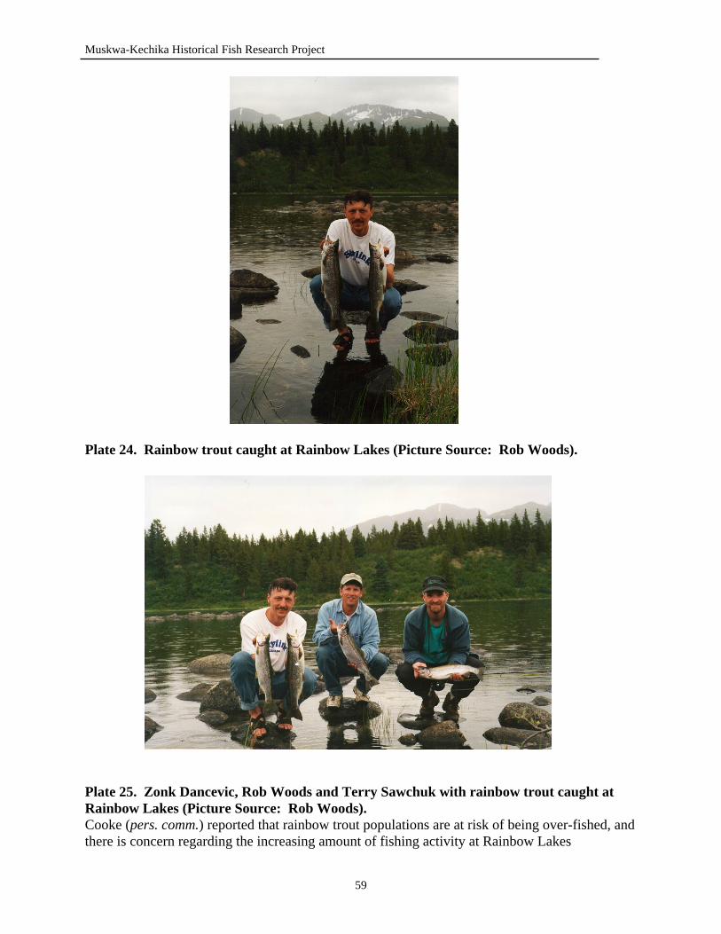
Muskwa-Kechika Historical Fish Research Project
Plate 24. Rainbow trout caught at Rainbow Lakes (Picture Source: Rob Woods).
Plate 25. Zonk Dancevic, Rob Woods and Terry Sawchuk with rainbow trout caught at Rainbow Lakes (Picture Source: Rob Woods). Cooke (pers. comm.) reported that rainbow trout populations are at risk of being over-fished, and there is concern regarding the increasing amount of fishing activity at Rainbow Lakes
59
Muskwa-Kechika Historical Fish Research Project
15.3 Blue Sheep Lake Located on Blue Sheep Creek, a tributary to the Major Hart River, Blue Sheep Lake is a small lake containing rainbow trout (MOELP, 2000b). Blue Sheep Lake, 58°46’ - 128°18’, has a perimeter of 7.2 km and a surface area of 25 hectares (MOELP, 2000b). Rainbow trout populations are not native to Blue Sheep Lake (Dalziel, pers. comm.). In 1963 to 1965, the lake was stocked with approximately 25 rainbow trout by George Dalziel (Dalziel, pers. comm.). The source of the rainbow trout is believed to be Gnat Lake and Tucho Lake, both of which are located outside of the MKMA (Bradford, pers. comm. and Dalziel, pers. comm.). The fish were angled on a barbless fly and brought to Blue Sheep Lake in buckets by plane (Dalziel, pers. comm.). The stocking was successful, and rainbow trout are still present in Blue Sheep Lake today (MOELP, 2000a). Spawning activity was noticed by Dalziel (pers. comm.) in Blue Sheep Lake. Specific locations were not given; however, Dalziel (pers. comm.) described spawning to usually occur in the main inlet and outlet creeks during ice break-up. A number of barren lakes were stocked with rainbow trout by George Dalziel. Two lakes located outside of the Muskwa-Kechika Management Area, Beale Lake and Meek Lake, were also stocked by Dalziel with rainbow trout (Dalziel, pers. comm.). Approximately 25 fish were angled on barbless hooks and brought to each lake by plane (Dalziel, pers. comm.). The source of all the rainbow trout introduced was Tucho Lake and possibly Gnat Lake (Dalziel, pers. comm.). The lakes were all stocked between 1963 and 1970 (Dalziel, pers. comm.). Denetiah Lake, Blue Sheep Lake, Meek Lake and Beale Lake, were all stocked with rainbow trout by George Dalziel (Dalziel, pers. comm.). Byron Dalziel (pers. comm.) reported that when the fish were introduced, it would take 2 to 3 years before any rainbow trout would be caught. Within the first 5 to 7 years, the fishing for rainbow trout was excellent, and a number of large fish would be angled (Dalziel, pers. comm.). However, the fishing eventually slowed down, and the size of fish being caught in the stocked lakes became noticeably smaller (Dalziel, pers. comm.). Dalziel (pers. comm.) believes this reduction in size is due to the amount of food available for the fish. During the peak of fishing quality, rainbow trout caught averaged 6 to 8 lbs. in size in all the stocked lakes. Dalziel (pers. comm.) reported that currently one cannot catch rainbow trout of this size anymore. 15.4 Turnagain River Originating outside the Muskwa-Kechika Management Area, at Turnagain Lake, the Turnagain River runs for 77 km until its confluence with the Kechika River. Major tributaries to the Turnagain River include the Major Hart River, Cassiar River, Kutcho Creek, and the Dall River (MOELP, 1997). Fish species present in the Turnagain River include Arctic grayling, bull trout and rainbow trout (MOELP, 2000a). Kirby Funnel, former guide outfitter, reported bull trout up to 4 lbs. in size and Arctic grayling ranging from 27 to 33 cm (11 to 13 inches) in length (MOELP, 2000a). Stream surveys have revealed Arctic grayling reaching sizes of 37 to 45 cm in length (MOELP, 2000a). Hart (pers.
60
Muskwa-Kechika Historical Fish Research Project
comm.) reported that fishing on the Turnagain River for Arctic grayling is excellent. Fly-fishing is reported to be the best method for catching the Arctic grayling (Hart, pers. comm.). A popular fishing location for many anglers is the confluence of the Cassiar River with the Turnagain River. Hart (pers. comm.) reported that many groups travel up the Turnagain River, in riverboats, to a set of waterfalls. This area, in particular, experiences a large amount of fishing pressure (Hart, pers. comm.). Rob Woods (pers. comm.) also reported catching Arctic grayling and bull trout at the confluence of the Cassiar and Turnagain Rivers. Frank Cooke (pers. comm.) discussed abundant numbers of bull trout, and described catching large bull trout, reaching lengths of 3.5 feet, in the Turnagain River. 16.0 DISCUSSION In discussion of research results, current management issues encountered during the interviews will be presented. Many suggestions and concerns regarding management of the fisheries in the Muskwa-Kechika Management Area were received from people interviewed. The most common management problems discussed was the issue of enforcement. Because of the large size and remoteness of the management area, consistent enforcement becomes an important issue. Views received from the interviews relayed the message of trying to increase the enforcement in the area, as much as possible, in order to reduce the amount of illegal hunting and fishing activities that occur. A large amount of the people interviewed discussed the newly implemented fishing restrictions during the spring. Both guide outfitters, commercial fishing operations and locals disagree with the new regulation. People of northern BC, that fish the streams and rivers, request more input and information regarding the restrictions. Locals in the areas would like to know the purpose of the regulations. The new stream restrictions have had a direct impact on the guide outfitters. As fishing becomes more popular in the area, guide outfitters are offering angling opportunities as part of their hunting or outdoor experience packages. However, with the new restrictions, fishing opportunities are becoming more limited. Commercial fishing operations have also been affected by the change in regulations, stating that the regulation is too restrictive and is not necessary to protect the fish. Many suggestions were provided in regards to the new regulation. People in the area would like to see the fish be protected; however, allow angling to continue, but impose a catch and release, or a single barbless hook restriction. In addition, imposing restrictions on the use of electronic fish locators in the northern lakes would protect the sensitive lake trout populations present in the mountain lakes. In talking with the many groups involved in fishing activities, I have found that groups which use the fishery in the Muskwa-Kechika Management Area, are concerned about fish populations within the area, and are co-operative with the regulations implemented and the enforcement of these restrictions. The majority of the illegal fishing that occurs is usually related to non-residents or “fly-in” fishing groups. Many of the lakes within the MKMA can only be accessed by horseback or aircraft. Patrolling and enforcing aircraft traffic into and out of these remote lakes is an expensive and time consuming task that is almost impossible to complete. People in the area are willing to work with the Fisheries department at the Ministry of Environment, to protect the fisheries resources of the area, while still allowing recreational fishing.
61
Muskwa-Kechika Historical Fish Research Project
Current fisheries issues that were addressed while conducting interviews included species of fish and water bodies which are at a potential risk of being over-fished or should have special management considerations. The species which was most widely described as a “potentially at risk species” are the bull trout and lake trout. Bull trout populations in the south-eastern portion of the MKMA, are at the greatest risk due to increasing industrial development and access, which increases the fishing activity. The major factors which prove to be detrimental to the bull trout include increasing riverboat use, primarily within the Tuchodi River system. Lake trout populations are affected primarily by heavy fishing pressure. The lakes located in the northwest Muskwa-Kechika Management Area, are of special concern regarding lake trout populations. Many of the lakes in this area hold very large, old lake trout. It has been described by many that one year of growth, in lake trout, is equivalent to one inch length increase. Therefore, harvesting a 20 inch lake trout, an additional 20 years will be required for another fish to reach this size. Because of the slow growing nature of this species, a lake trout population can easily be fished out of the small northern lakes, which provide optimum habitat for the species. Additional pressure also resides on the lake trout, as it is a popular sport fish and is heavily sought after by many anglers. Water bodies that are at risk of becoming over-fished include the Tetsa River, Toad River, MacDonald Creek and Muncho Lake. Because of their locality, these streams and lakes are most accessible to heavy traffic and fishing pressure. Many people interviewed discussed the current pressure that is being experienced on these water bodies and the prediction of increased activity in the future. In areas such as the Tetsa River and Muncho Lake, where access is not hindered, enforcement should be increased during specific seasons, to prevent the harvesting of excessive fish. The Tuchodi River system is also of concern. Increasing riverboat use on the river draws concern to the bull trout populations, during the fall, when the bull trout spawn. Management suggestions include developing regulations during this time to limit the amount of riverboat use, and to ensure the smaller lakes in the area are not over-fished. In conclusion, this report has explored the historical knowledge and current management issues related to the fisheries within the Muskwa-Kechika Management Area. It has provided insight to the fisheries of many pristine and unfamiliar areas within the management area, and will provide a background information base for future work and research completed. 17.0 RECOMMENDATIONS In future historical studies like this, consideration should be given to the contacts in which the majority of the required information will be obtained from. Problems associated with this project include the timing of the project. A large proportion of the people contacted for information were guide outfitters. Due to their business season during the summer and early fall, a summer contract does not complement the schedules of the guide outfitters. In future studies, I would suggest conducting the project during the winter months, when most people are available for interviews. Many of the people who were not interviewed, were simply not available. In discussion with the guide outfitters, all were willing to cooperate, however, timing was not appropriate for their schedules.
62
Muskwa-Kechika Historical Fish Research Project
Due to the locality of the Muskwa-Kechika Management Area, contacts were widely distributed throughout the entire province. Many interviews had to be completed by telephone due to high travel costs. Although effective, telephone interviews are impersonal and information is usually not as complete as in personal interviews. In avoiding this problem, I would suggest distributing a letter to all possible contacts, prior to interviewing, describing the project undertaken, what knowledge would be required of them and requesting the most convenient time for an interview. This would allow contacts to prepare for the interview, and thus have the most available information. Not included in this report, are details of First Nations’ use fisheries. It was discovered that in order to obtain information from the First Nation Bands, a long and detailed process must be undertaken. This process was not anticipated, and thus First Nations’ fisheries knowledge and history has not been completely included. However, with the cooperation of the First Nations Bands within Treaty 8, a traditional use study should be undertaken to determine the historical uses and knowledge of the fisheries within the First Nations’ territories. In discussion with many band representatives and chiefs, it was discovered that in cooperation with the bands, there is great potential and interest for an additional project of this type. Many contacts were not reached, and a great amount of historical fisheries information has not been explored. In addition to this report, a second research project can be undertaken in order to reach those who were not able to be contacted, and to elaborate on the information obtained to provide a more complete information base.
63
Muskwa-Kechika Historical Fish Research Project
18.0 LITERATURE CITED Davies, G. E. 1996. The living rivers of British Columbia and Yukon: Volume 2.
Vancouver: Ronsdale Press. de Laronde, J. M. 1997. Exotic species in the Peace sub region (7b). Unpubl. Rep.,
Fisheries Branch, Ministry of Environment, Lands and Parks, Fort St. John, BC. Dyer, B. March 22, 2000. Time Capsule. Alaska Highway News, Fort St. John, BC. Fryer, H. 1974. Bill goes a fishing. Northwest Sportsman October-November: 23-24. Henry, M. G. 1934a. Collecting plants beyond the frontier in northern British Columbia.
National Horticultural Magazine. January 1934: 60-75. Henry, M. G. 1934b. Collecting plants beyond the frontier in northern British Columbia:
Part II. National Horticultural Magazine. April 1934: 162-181. Henry, M. G. 1934c. Collecting plants beyond the frontier in northern British Columbia:
Part III. National Horticultural Magazine. July 1934: 269-290. Henry, M. G. 1934d. Collecting plants beyond the frontier in northern British Columbia:
Part IV. National Horticultural Magazine. October 1934: 363-383. Henry, M. G. 1935a. Collecting plants beyond the frontier in northern British Columbia.
Part V. National Horticultural Magazine. April 1935: 132-156. Henry, M. G. 1935b. Collecting plants beyond the frontier in northern British Columbia.
Part VI. National Horticultural Magazine. July 1935: 232-257. Ministry of Environment, Lands and Parks. 1997. British Columbia Recreational Atlas
(4th ed.). P.T.C. Phototype Composing Ltd.: Victoria, BC. 142 pp. Ministry of Environment, Lands and Parks. 1999. Protected areas of the Muskwa-
Kechika Management Area: background document. Prepared for British Columbia Ministry of Parks, Victoria, BC. 158 pp.
Ministry of Environment, Lands and Parks. 2000a. Fisheries Information Summary
System files. Fisheries Branch, Ministry of Environment, Lands and Parks, Fort St. John, BC. <http://www.env.gov.bc.ca/fsh>
Ministry of Environment, Lands and Parks. 2000b. Fish Wizard.
Fisheries Branch. <http://pisces.env.gov.bc.ca/FishWizard.asp> Ministry of Environment, Lands and Parks and Ministry of Fisheries. 2000c. Freshwater
64
Muskwa-Kechika Historical Fish Research Project
fishing regulations synopsis. Ministry of Environment, Lands and Parks and Ministry of Fisheries, Victoria, BC.
Scott, W. B. and E. J. Crossman. 1973. Freshwater fishes of Canada. Ottawa: Fisheries
Research Board of Canada. 966 pp. Sheldon, W. G. 1981. Exploring for wild sheep in British Columbia in 1931 and 1932.
Clinton, New Jersey: Amwell Press. Watson, J. H. 1989. Personal journals. Unpublished.
65
Muskwa-Kechika Historical Fish Research Project
19.0 PERSONAL COMMUNICATIONS Baker, Jack. June 21, 2000. Beattie, Don. May 21, 2000. Former Guide Outfitter, Sikanni Chief River Outfitters, Fort St.
John, BC. Bradford, Sherrie. July 2, 2000. Guide Outfitter, Dease Lake, BC. Brown, Wes. July 3, 2000. Former Guide Outfitter, Besa River. Cooke, Frank. July 4, 2000. Former Guide Outfitter, Kechika River. Dalziel, Byron. August 9, 2000. Former Guide Outfitter, Kechika River. Down, Ted. July 20, 2000. Fisheries Biologist, Victoria, BC. Drinkall, Dale. June 28, 2000. Guide Outfitter, Folding Mountain Outfitters, Toad River, BC. Hamilton, Dave. July 28, 2000. Fisheries Biologist, Prince George, BC. Hansen, Al. August 9, 2000. Ministry of Environment, Lands and Parks, Muncho Lake, BC. Hart, Jim. August 1, 2000. Ministry of Environment, Lands and Parks, Fort Nelson, BC. Kjos, Bob. June 17, 2000. Former Guide Outfitter, Toad River. Kyllo, Dave. July 3, 2000. Palmer, Dwayne. July 21, 2000. Former Guide Outfitter, Besa River, BC. Peck, Ross. June 21, 2000. Guide Outfitter, Ross Peck Outfitters Ltd., Fort St. John, BC. Powell, Olive. July 2, 2000. Former Guide Outfitter, Gathto Creek. Rutledge, Leo. June 21, 2000. Former Guide Outfitter, Prophet River. Schildknecht, Urs. August 14, 2000. Angling Guide, Muncho Lake, BC. Vince, Garry. June 28, 2000. Former Guide Outfitter, Muskwa River Safaris Ltd., Fort St. John,
BC. Watson, Darwin. May 22, 2000. Guide Outfitter, Christina Falls Outfitters, Hudson’s Hope, BC. Watson, Marlin. July 28, 2000.
66

Muskwa-Kechika Historical Fish Research Project
Wiens, Dave. July 13, 2000. Guide Outfitter, Stone Mountain Safaris Ltd., Toad River, BC. Wolf, Brian. July 30, 2000. Prophet River First Nations, Prophet River, BC. Woods, Rob. 2000. Wildlife Technician, Ministry of Environment, Lands and Parks, Fort St.
John, BC.
67

Muskwa-Kechika Historical Fish Research Project
APPENDICES
68
Muskwa-Kechika Historical Fish Research Project
Appendix I: Standard Set of Questions Used During Interviews. 1. Are you aware of any fish stocking that has occurred to any lakes and rivers within your area
as well as other areas? 2. Which water bodies were stocked? 3. What species were stocked? 4. What size range of fish? 5. How many were stocked? 6. When were they stocked? 7. Who stocked the lakes? 8. What is the source of the stocked fish? 9. What was the purpose of the stocking? 10. What fish species were in the water bodies before stocking occurred? 11. Are you aware of any changes in fish populations? Do you know why the population
changes occurred? 12. What was the average size range of fish that were either caught or observed in the
watersheds? 13. Did you notice any common areas for fish? Either popular or good fishing location? Ex: at
base of waterfalls or certain pools? 14. What were the dominant fish species caught or observed? 15. Which were the most popular fishing lakes or rivers? 16. In your opinion, are there any fish species which may or are be at risk? 17. Do you know of the location of spawning runs or rearing habitats? 18. Are there any water bodies that are at risk of being over-fished? 19. Do you have any photographs of fish species present? 20. Do you know of anyone who would have any further information on fishing within the
Muskwa-Kechika? 21. Do you have any concerns or suggestions relating to the management and use of fisheries
resources (not just fish population, but habitat as well) in the MK? Some Additional Questions that were asked depending on the people being interviewed: 1. Has the quality of fishing changed? 2. Where were some of the most popular fishing areas? 3. What was the best time of year to fish? 4. Were there factors that influenced the fishing quality, fish habitat, or populations? 5. What methods were used to fish? 6. What were the purposes for fishing? 7. What fish species were caught? 8. What were the major fishing pressures experienced? 9. Do you know of any illegal fishing that took place? 10. In general, is fishing (either recreational or sport) increasing in the area?
69
Muskwa-Kechika Historical Fish Research Project
Appendix II. Interview Summaries. 2.1 Don Beattie - May 21, 2000.
Mile 36 Café 1. Trimble Lake: In 1959, Trimble Lake was stocked with two loads of Arctic grayling. The fish were brought to the lake by an oil company (Imperial Oil) from west of the Rocky Mountains. The actual location of the source of the fish is unknown, but Don mentioned the Finlay area as a possible source. The first load of fish contained 17 grayling; the second load contained 19 grayling. No mountain whitefish were known to be brought over. The fish were brought to Trimble with a Beaver plane. In early spring (May), the outlet of the lake, Trimble Creek, is the location of the spawning grayling. From the plane, the mouth of the creek looks black from the spawning fish. Now, Rainbow trout can also be caught in the lake. They have moved up the river from Marion Lake. Trimble Lake was barren before the stocking occurred. Beattie Lake is a clear water lake. 2. Pass Lake (Sikanni Chief Lake): In the early 1980’s Pass Lake was stocked with Arctic grayling from Trimble Lake. With the help of a fisheries biologist from Prince George, the fish were tranquilized using a powder. The fish were brought in to Pass Lake from Trimble Lake using Short Tompkins’ float plane. The amount of fish stocked is unknown. Elmer Olsen was involved in this stocking as well. 3. Marion Lake: In the early 1970’s, Marion Lake was stocked with Arctic grayling from Trimble Lake. The fish were brought to the lake with the float plane. The fish were angled (therefore the size range of fish brought in was diverse) and transported in plastic containers. A hose was connected to the containers from outside of the plane to provide oxygen for the fish. Don said they had approximately forty minutes to transport the fish before they started to die. The number of fish that were brought into the lake is unknown. Don said that he never stocked the lake with rainbow trout. Marion Lake was not a good lake for fish, as it had a mud bottom. 4. Beattie Lake: In 1978, Beattie Lake was stocked with Rainbow Trout. The lake was barren before. The fish came from a hatchery near Mission, BC. 5000 fingerling Rainbow Trout were dropped from approximately one hundred feet above the lake. They opened the doors of the plane and dropped the fish. Don said they never noticed any dead fish or knew how the fall affected the fish. Don mentioned that the fish grew very fast and big. Decided to stock the lake because it was clear and not glacial. The largest rainbow caught out of Beattie Lake, that Don is aware of, was 17-18 lbs. rainbow trout. 5. Fairy Lake: Fairy lake was also stocked with Rainbow trout. Don is unsure of the date or number of fish. 6. Bluebell Lake (57°12.5’ - 124°00’): Don stocked Bluebell about 15 years ago (1985) with rainbow trout which came from Beattie Lake. The fish were angled from Beattie Lake, put in plastic jugs, and flown to Bluebell Lake.
70
Muskwa-Kechika Historical Fish Research Project
Approximately 30 fish were put in the lake. There are also Arctic grayling in the lake which have come into the lake from the stocking of Pass Lake with grayling. The are no barriers which prevent the fish from leaving the lake. Don said that the rainbow trout move downstream. 7. McCusker Lake: Don stocked this lake with rainbow trout about 15 years ago (1985). When the river gets high, the lake becomes washed out. They never caught rainbow in the lake; they believed that the fish got swept downstream in high waters and never remained in the lake. About 30 fish were put into this lake. McCusker Lake is close to Bluebell Lake. The source of the rainbow was Beattie Lake. They were angled and brought over to McCusker Lake. 8. Cranswick Lake: Don never stocked this lake, but he said it has prime habitat for fish. It is spring fed and it does not encounter glacier water. There are several beaver dams downstream, which prevent Arctic grayling from coming up into the lake from Trimble Lake. • in the past, there used to be no fish above Sikanni Falls • now, fish can be caught throughout the entire river 9. Letain Lake A 30 lbs. rainbow trout was caught out of the Letain Lake (out of MK) (Spring 2000). 10. Muncho Lake A 42 lbs. lake trout was caught out of Muncho Lake (Spring 2000). The fish was at least 8 inches wide
71
Muskwa-Kechika Historical Fish Research Project
2.2 Darwin Watson - May 22, 2000. Phone conversation
1. Lady Laurier Lake: Around 1978-79, Lady Laurier was stocked with rainbow trout by Darwin Watson and company. The rainbow were present in the lake for 5 or 6 years. When they were stocked they were young. The fish were purchased from Vancouver and brought up in a plane. The fish grew to be “huge”, when they were present. However, the rainbow trout never reproduced. The only fish that were ever caught were the original fish brought in. They never saw any sign of young rainbow trout in the lake. Darwin suspects that the fish were infertile as they came from a hatchery, and some of the hatcheries raise fish to be infertile. This would explain why the fish never reproduced and the presence of primarily large, mature fish. A year after the stocking of rainbow trout, Lady Laurier was stocked with Arctic grayling that came from Trimble Lake. They were transported using a float plane. No indications of grayling for several years. When the Rainbows started to die out, the Arctic grayling started to explode. The fish (Arctic grayling) were stocked by Elmer Olsen. Only 9 or 11 fish were brought in to the lake. The average sized fish that are caught are approximately 18 inches in length. In 1986, Darwin remembers fishing in the outlet of the creek and seeing a lot of young fish. At first they thought they were rainbow trout, but once caught, realized they were grayling. The inlet creek is ideal habitat for spawning because of the sandy bottom. Darwin said he has never fished up there. The outlet is less likely of a spawning creek as it is wild and fast. However, that is where he has seen the majority of young grayling. Dolly Varden spawn at the head of the Graham River in late fall.
72
Muskwa-Kechika Historical Fish Research Project
2.3 Bob Kjos - June 17, 2000. Kjos Residence, Montney, BC
Bob Kjos owned the Toad River Lodge from 1966 until he sold it in 1969. He also owned a guide area, bought from Joe Dall, from 1966 until he sold it in 1980. However, he remained active in the guide territory until 1985. While guiding in the area, he lived on a ranch on the Toad River. 1. Stocking: Bob had never done any stocking. Red Saurenson had stocked a lake (Mile 422) west of his area off the Otelsas Creek which runs into the Toad River. See lake location on Tuchodi Lakes map. Bob did not know what species of fish was stocked or the name of the lake. He believes that the lake was stocked in the early 1970’s. The lake itself is a land-locked lake, about one quarter of a mile long . Bob did not know how productive the stocking was and whether the fish population ever took off. 2. Racing River: The Racing River is a glacier fed river, so it is very murky. Bob commented that river was not bad fishing at times, especially when the water was clear. At the head of the Racing there are some good fishing holes. The best fishing on the Racing was where the little clear creeks flowed into the Racing. He said it was really easy to catch fish there. There was a mine put in, on the Racing River, just as Bob obtained his guide area. The tailings ponds were washed out with high water levels on the Racing River. Above the confluence of the Toad and the Racing, the Toad was not affected by the mine and the tailing wash-outs. However, downstream on the Toad River was affected. Bob believes that the mine killed a lot of fish. Another mine was put in around Mile 442, near Moose Lake. This mine was located directly over the mountain from the mine situated on Delano Creek. Both mines were eventually closed due to high costs of construction on roads. 3. Wokkpash Lake: Wokkpash Lake is also glacier fed and therefore the fishing is ultimately affected by the murky water. Bob said they would get good fish only when the water was clear. They would catch fish up to about 10 lbs. in Wokkpash Lake. Bob commented that above Wokkpash, there were spawning areas. In his guide area, Bob said the streams [in general] are very fast and do not have many pools. Therefore, fishing is more difficult. 4. Chischa River: The Chischa River (also know as Sheep Creek by Bob and others) provides good fishing below the falls. Bob said he once thought of bringing fish from below the falls to upstream above the falls as there are good “holes” above the falls. He never did move any fish. Chlotapecta Creek (also known as 4 Mile Creek by Bob) provided good fishing below the falls. Just as Chlotapecta Creek enters the Muskwa River, there is a pool just below the falls there is good fishing in the pool. 5. Tetsa Lake:
73
Muskwa-Kechika Historical Fish Research Project
Tetsa Lake was the most prominently fished lake by Bob, his crew and clients. He said it is good fishing at the lake. The fishing quality and abundance of fish in the lake has not changed over the years. He suggests this is probably due to the remote and hard to access location of the lake. The largest fish they ever caught out of the lake was approximately 8-10 lbs. (Lake Trout). However, on many occasions, they observed fish 3 to 4 feet in length and at least 6-8 inches deep. When fishing was really good in the lake, the little ones would always be on the line before you could catch the big ones. In regards to management, Bob believes that Tetsa Lake is good fishing because people cannot easily access the lake. He believes that if more people could access and fish the lake, the fishing would not be as good. Tetsa Lake will protect itself from over fishing. The lake is not big enough to land a float plane on and is hard to access otherwise. 6. Tetsa River: Tetsa River is good fishing. Where the river comes close to the road is usually fished heavy. There are many good fishing holes on the river. 7. Summit Lake: Summit Lake is also in Bob’s area, but he has never fished it. He always used to see lots of people fishing there. The lake itself is not very deep; only 20 feet at the deepest point. Bob also mentioned that he used to catch a lot of fish out of Moose Lake. There are a lot of other high elevation lakes, but he does not know about the fish in the lakes. Some of these high elevation lakes are frozen year-round. Arctic grayling are present in all streams; Toad River and Tetsa River were mentioned. Lake trout in the lakes. The big rivers (Toad, Tetsa, Racing) are good fishing in the spring when the fish are moving up stream. Bob said that fishing in his area was never really good. Fishing got better and was really good over in the Pacific Watershed. He used to fly over to fish in the winter with his plane. 8. Muncho Lake: A lady by the name of Rose Mold still holds the record (he believes) for largest lake trout caught in Muncho Lake. Her fish was 34-37 lbs. In the Toad River, Bob has caught fish approximately 7-8 lbs. Using arm gestures, he showed me the approximate size: 3-4 feet in length and 6 inches deep. 9. Klua Lakes: Bob used to fly loads of fish out of Klua Lakes for a man named Wayne Fell. Wayne had commercial nets in which he would catch Rocky Mountain whitefish. Picture #1: Lesley Fingers, from Texas, caught fish in Toad River close to Bob’s residence. (date unknown) Picture #2: Lake trout caught in Toad River by the ranch in 1975. Used to catch lots of fish around this size. Picture #3: Lake trout caught in Tetsa Lake, September 1971.
74

Muskwa-Kechika Historical Fish Research Project
Also had another picture which he couldn’t get out of photo album. Fish caught by his son and Lesley Fingers in the Tetsa River. Bob also said he had movies of fishing on 16mm film. 10. Spawning Activity: When asked about spawning areas, Bob said he never paid enough attention to what was going on with the fish. He did say that the little creeks on the Tetsa and Toad Rivers were common spawning grounds and that the fish would travel up as far as they could.
75
Muskwa-Kechika Historical Fish Research Project
2.4 Ross Peck - June 21, 2000. Peck Residence, Montney, B.C
Ross Peck took over his father’s, Don Peck, Guide Outfitter Territory. He has been in the area since 1956. Don Peck has been in the area since 1948. Ross has a angling license. Most of the fish guiding is done over in Fern and Chesterfield Lakes. 1. Tuchodi Lakes: In 1961 (1959-62 time frame), rainbow trout were stocked into the East Tuchodi Lake. The source of the fish was a hatchery in Kamloops. The fish were dropped off the end of the airstrip, where there was a pile of logs, into the first bay of the lake. 10, 000 fish were put into the lake (written on cabin wall). The fish were fingerlings. The rainbow trout never survived. Jimmy Anderson was involved in the stocking. The Pecks have never caught any rainbow trout in the lake. The possible reason for the fish not surviving is water temperature problems - too warm/too cold. Some netting was done following the stocking, but no Rainbow trout were ever caught. In July, the Tuchodi Lakes can be tough fishing due to the high waters. When the ice comes off, fishing for lake trout can be good. There have been periodic peaks of ice fishing. Ice fishing can be good. There was some illegal fishing that goes on during the winter. Jim Hart (Conservation Officer) would be a contact. 2. Fern Lake: Don Peck bought this portion of their guide area from Jack Powell in the mid 1960’s (1966-68 approx.). Rainbow trout were stocked about this time. The fish introduced into the lake were adults, that were caught out of the Rainbow Lakes on the head of Weisner Creek drainage. Approximately 30 fish were transported by buckets to Fern Lake. The transplant was very successful. Before the stocking the lake was barren. There was a good freshwater shrimp population in the lake, which may be the reason for such success of the rainbow trout. Ross has caught some 15 lbs. fish out of Fern Lake. There are now catch and release regulations placed on the lake. Ross believes the fish are spawning in the lake. He has never seen any rainbow trout in the Muskwa system: most likely due to the siltyness from the glacier. 3. Spawning Areas: The bull trout spawn between the two Tuchodi Lakes in early September. There are great big bull trout in the area at that time. The rainbow trout in Fern Lake would spawn in gravel of outlet and inlet creeks The grayling in the Tuchodi River leave the system in the winter; and come back in the spring. The whitefish stay in the Tuchodi system over the winter: Ross has found otter scats with fish scales in them. He believes they are scales of the mountain whitefish. 4. Common Species Caught: On the east slope of the Tuchodi Lakes, Arctic grayling and bull trout are the most common fish caught. The grayling are approximately 14-16 inches on the average. On the west side of the
76
Muskwa-Kechika Historical Fish Research Project
mountains, rainbow are the most common fish. 5. Chesterfield Lake: About 8-10 years ago (Aug.15, 1990), noticed a large die off of rainbow trout and whitefish. The die off didn’t affect the bull trout as much as the other two species. The theory for this die off is a turnover in water causing a possible lack of oxygen. In the last couple of years, the populations are just starting to come back. 6. Fishing Pressure: The Tuchodi system gets fished quite often. There is an increasing amount of summer activity in the last 5-10 years. The riverboats are the cause of this increasing activity. The river fishing has increased with increasing amounts of traffic. 7. Fishing Changes: The fishing quality hasn’t changed. The summer fishing is dependant on water levels and the amount of rain which make the waters murky. 8. Fish Concerns: Bull trout populations are of concern during the fall. The boats can have an impact on spawning habitat. 9. Management: Some management issues that must be addressed include enforcement (lack there of), potential over-fishing in winter and spring, managing boat use, and more research on fisheries use and habitat. 10. Kluachesi Lake: Ross remembers there being transplants in or out of Kluachesi Lake - a possible connection with Trimble Lake - when early Geology Prospecting Parties were in the area. Ross remembers catching grayling in 1956 in Kluachesi Lake. In 1957, Ross caught bull trout in a clear little stream on the flat off the Muskwa River by Garry Vince’s main camp.
77
Muskwa-Kechika Historical Fish Research Project
2.5 Jack Baker - June 21, 2000. Baker Residence, Grandhaven, BC
Jack said that he once flew in to Denetiah Lake (a date or year was not given), but I am guessing around 40 years ago. He said he caught rainbow trout up there ranging in size from 5-6 lbs. There was a cabin on the lake that was owned by Okranic (died in the plane crash on Charlie Lake). When asked about other fish species that were caught or that he knew were in the lake, he said that he didn’t know. Stated that rainbow trout were the ones they always caught and were definitely the most abundant of the fish in the lake. In quoting Jack, “good fishing in there” referring to Denetiah Lake. He went on to say that it is a cold lake that is part of the Finlay River system. When talking with Jack and his wife, Claris, they mentioned the Gataga River. Claris said that they used to catch grayling and Dolly Varden in the Gataga, but Dolly Varden are closed to fishing now. When Jack did fish, it was usually to feed his dogs or just enough for him to eat. He lived in Fort Liard for 3 years. Used to fish in Weissener Lake during the winter. They caught a huge fish during the winter (at least 3 feet in length judging from the picture). He also fished at Tatlatui Lake. He said the fish were not big there (approx. 2 lbs.). “Every time you cast there was a fish on there” referring to Tatlatui Lake. Jack used to trap along the Graham River with Bobbie Beattie. He said it wasn’t a great river for fishing. Jack also mentioned the South Gataga Lakes, but never ended up telling me about the fish in those lakes. Said the lakes were never individually named; just known as South Gataga Lakes.
78
Muskwa-Kechika Historical Fish Research Project
2.6 Leo Rutledge - June 21, 2000. Rutledge Residence, Hudson’s Hope, BC
Leo never fished a lot when he was guiding in the area, mainly because there was no money in the fishing industry. There was very little interest in fishing except to provide food, but there was never a shortage of meat from hunts. Hunters also did not show any interest in fishing. Leo guided in the area for 42 years. He has lived on the Peace River since 1945 and in the Peace Country since 1929. In 1975, Leo made a 16 mm film of the area in order to educate people of the province of the big game and landscape of the area. 1. Prophet River: The Prophet River had some grayling in it; they were ordinary size grayling (approx. 18 inches), also Dolly Varden. There were no rainbow trout in the system. The whole watershed itself was not great for fishing. At the confluence of the Prophet and the Minaker there was fairly good fishing during some years. At the confluence of Richards Creek and the Prophet River was good fishing. Upstream Richards Creek was good for grayling. Other species he remembers catching were squaw fish. One little creek, a tributary to the Minaker, he saw, during the spring, lots of pink fish struggling to get up the creek. He believes they could have been spawning. There were no “famous” pools for fishing. There were no great lakes of any consequence. Any lakes that were there, were high in elevation, and usually glacier fed. “Wasn’t great fishing country” 2. Peace River: In the Peace River, he used to catch Dolly Varden, Arctic Grayling, and Rainbow Trout. Had excellent fishing on the Peace until the W.A.C. Bennett Dam was put in. The grayling vanished when the dam was put in. He remembers areas where there were shallow gravel fans, where you couldn’t see the bottom of the stream as there were so many fish in the shallow waters. 3. Stocking: He doesn’t remember any one ever stocking fish in his area. He made mention to Trimble Lake and fish moving activity in that area. When asked if there is suitable habitat up there for fish, he responded that “whatever fish that could survive there, would be there.” Most of the streams in his area are glacial fed. When asked about management, he responded, “the biggest assets to the area would be if the Fish and Wildlife branch would leave it alone”. 4. Graham River: He remembers fishing below Christina Falls, in the 1940’s, on the Graham River. They caught a 21” Rainbow Trout at the pool at the bottom. He also mentioned that they caught Dolly Varden above the falls on the Graham. In Redfern Lake he said they caught some big fish; South Gataga lakes were stocked.
79
Muskwa-Kechika Historical Fish Research Project
2.7 Garry Vince - June 28, 2000. Tim Horton’s, Fort St. John, BC
Garry was first in the area in 1951, when he guided at the Halfway River. Around 1954-56 he moved up to the Muskwa River and has been there since. 1. Grizzly Lake: Grizzly Lake was stocked many times. On July 12, 1964, the lake was stocked with 5000 rainbow trout that were fingerlings. The source of the fish was the Loon Creek Hatchery north of Clinton, BC. The fish were transported to the lake via supercub. The fish are dropped from the plane at an altitude of 80 ft at approximately 80 M/hr. Al Henderson was involved with this stocking. The second stocking came from the Abbotsford Hatchery. Another 5000 Rainbow trout, fingerlings, were dropped into the lake. The second bunch of fish were stocked in 1971-72. The fish were put in large buckets with oxygen pumped into them. The rainbow trout spawned for a little while, but there were too many fish for the freshwater shrimp population. The fish grew very fast, suggesting that there was good food availability for them. Garry also brought up 2 bull trout and 3 Arctic grayling in packboxes on horseback in 1960. The panniers were ¾ full of water. In order to keep the fish alive, they had to stop at streams and rivers to replenish the water. The bull trout and Arctic grayling were angled in Crehan Creek and packed for 2 ½ hours to Grizzly Lake. They have caught rainbow trout in Grizzly Lake up to 10 lbs. The average size of fish was 14”. There is an excellent freshwater shrimp population in the lake, and that is believed to be the reason why the rainbow trout survived so well. Within the first year after stocking the lake with 2 bull trout, they were fished out by Garry and crew. Never caught bull trout in the lake since. The Arctic grayling, however, spawned and are still in there today. Grizzly Lake is a spring fed, landlocked lake and very deep (125 ft??). Spawning is believed to occur by wind action (wave spawning). About 8-10 years ago, fishing started to decline. Since then, fishing has not been as good as it was. Garry suggests that there should be a season for the area to prevent the lake from being fished out. 2. Halfway River: During the early 1950’s, Garry remembers catching some big rainbow trout in the headwaters of the Halfway River. 3. General Fisheries in his guide area: The best fishing areas and habitat is in the slow-running and deep rivers. The most dominant fish species in the area are bull trout and Arctic grayling. The most threatened fish species is the bull trout. Crehan Creek used to be good fishing, but isn’t anymore. Mountain whitefish used to be caught in the larger rivers; however, very few are caught now. Major reasons for decreasing fish populations include over-fishing, changes in water courses due to wash-out, and the increasing riverboat use. In the north Sikanni, used to catch 8-10 Arctic grayling and bull trout fish in one fishing for a meal. They are still good fishing, but not anywhere compared to what it
80
Muskwa-Kechika Historical Fish Research Project
used to be. The pools were always good fishing. 4. Muskwa River: In late October, in pools in the Muskwa River, they used to be able to catch a feed of fish (8-10 fish). Due to the murkiness and glacial waters, the river is really hard to fish. Garry wonders how old the fish in the river are, because sometimes when the river is really cold or murky, growth doesn’t occur at what it normally would. 5. Management Concerns: Garry suggests fishing season be implemented in the area, to ensure the area isn’t over-fished. A season during the fall is most important as the riverboats have a real affect on the bull trout populations.
81
Muskwa-Kechika Historical Fish Research Project
2.8 Dale Drinkall - June 28, 2000. Phone Conversation
Dale has been guiding in the area since 1983. 1. Stocking: The only stocking that he is aware of is in Muncho Lake. He believes that the Ministry of Parks stocked the lake with Rainbow trout approximately 5 years ago. 2. General Streams: The common fish species in the rivers is the Dolly Varden. They have caught fish up to 15 lbs., but the average fish size they catch is 2-5 lbs. In the higher elevation streams, Arctic grayling is the dominant fish. The average size Arctic grayling caught is 1-1.5 lbs. There are some whitefish present, but not very numerous. 3. Spawning: The only spawning areas that Dale has noticed was at the base of the waterfalls on the Toad River, where there is an abundance of Arctic grayling and Dolly Varden. In regards to management, there is becoming more of a growing demand on the fisheries in the area. More people and hunters want to fish; as a vacation type of activity. When hunters are done their hunt, they want to fish the area. There are some site specific areas that get hit harder than other areas. An example of this is Moose Lake on the Toad River. In Dale’s opinion, this lake is over-fished. There is easy access in both winter and summer. During the winter, skidoos can go directly into Moose Lake and ice fishing is very common. Dale’s suggestion for management is fishing regulations (example of catch and release) rather than complete closures on the entire system. The fish that occur in Moose Lake are Dolly Varden, Arctic grayling, and Mountain whitefish (possibly lingcod as well). Dolly Varden are the species which are the most affected by the over-fishing occurring in the lake. Dale does not have many lakes within his area. All the lakes are high elevation and most of them are barren. He stated that the good fishing is in the Trench and on the other side of the divide. A more recent topic that Dale discussed was the recent closures on all watersheds in the area. The Toad River, Racing River, and MacDonald Creek are all under this closure. The major complaint that is occurring over the closures is the lack of public knowledge and input into the decision. Why was it put into place? For how long will the closures be in affect? What was the objective of these closures? These closures have created a dramatic impact on the Guide Outfitting industry as many hunters want fishing to be part of their hunt, but now it is not permitted. The large issue is the public knowledge. Residents of the area want to know the why’s of these closures. Public in Toad River are also very upset at the recent closures.
82
Muskwa-Kechika Historical Fish Research Project
2.9 Olive Powell - July 2, 2000. Phone Conversation
Olive Powell is the wife of Gary Powell, who guided in, what is now Barry Tompkins area. Major watersheds in the area include Gathto Creek and Kluachesi Lake (which they called Blue Lake). They guided in this area from 1960-1986. They also guided within the Muskwa-Kechika area before the Guide Outfitter boundaries were set. 1. Gathto Creek: The dominant fish species in Gathto Creek is bull trout. In other side streams they caught bull trout and mountain whitefish. In pools off the side streams, they would catch bull trout up to 30”. In Kluachesi Lake, they caught Arctic trout (Arctic grayling), the odd ling, and bull trout. The Arctic trout ranged in size from 16-17”. Olive said that the size of fish was very uniform in Blue Lake. Bull trout caught were around 20-21” in length. When asked about popular fishing locations, Olive said that due to consistently changing water, pools would come and go depending on the amount of water within the watershed. The best fishing was during the earlier part of their season: late July, August and early September. Fishing was not good in the area.
83
Muskwa-Kechika Historical Fish Research Project
2.10 Dave Kyllo - July 3, 2000. Kyllo Residence, Hudson’s Hope, BC
Dave’s experience is not directly related to the Muskwa-Kechika. He has lived in the area for 65 years, and has fish guided throughout the Peace River system; before and after the dam came. He guide up into the Finlay Forks from 1954-68. From 1972 he guided anglers on Williston Lake. • Creek mouth are heavily fished for Dolly Varden • Streams coming into the lake are accessible • River fisheries has improved since the dam • Arctic grayling prominent after reservoir • 18” was the largest Arctic grayling they caught • 12-18” was the average size of AG
84
Muskwa-Kechika Historical Fish Research Project
2.11 Sherry Bradford - July 2, 2000. Phone Conversation
1. Rainbow Lakes are natural lakes that were never stocked. They contain Rainbow trout and
Dolly Varden. 2. Denetiah Lake was stocked in 1958 by George Dalziel (Sherry’s father). Before the stocking
the lake was barren. It was stocked with Rainbow trout that were caught with a barbless hook from both Gnat Lake and another lake. A couple dozen fish were brought over in wash tubs in the plane. The average size that were brought into the lake was 8-10 inches in length.
3. George Dalziel was a Guide Outfitter in the area since 1929. His daughter and son-in-law,
Sherry and Myles Bradford, now own the Guide Outfitter territory.
85

Muskwa-Kechika Historical Fish Research Project
2.12 Wes Brown - July 3, 2000. Brown Residence, Fort St. John, BC
Wes started guiding in the area in 1937, before Guide Outfitter boundaries were established. After guide boundaries were developed, Wes was allocated the area which is now the south-western portion of Paul Gillis’ guide area. His area encompassed the Buckinghorse River south to the Sikanni River; between Keily Creek and Richard’s Creek. He guided in the his guide territory for 20 years. The lakes that were in his area included Redfern Lake and Fairy Lake. 1. Fairy Lake: Fairy Lake was barren to begin with. However, Wes said, “there were lots of bugs there, so you could see it was an alive lake”. Rainbow were planted in the lake, by the Ministry of Environment, and have done really well. Wes always fished through the ice, but never had much success. Fly fishing in the summer, sometimes yielded 5-6 lbs. rainbow trout. The average size fish caught was 5-6 lbs. One in awhile you would catch some bigger. Above Fairy Lake there is another small lake, approximately one quarter to half a mile long. This small little lake acts as a sediment bowl. By the time the glacial water gets to Fairy Lake, most of the silt has settled out of it. During heavy run-offs, Fairy Lake could get partially silty. 2. Redfern Lake: Redfern Lake never looked good for fishing. The vegetation within the lake always had a coat of silt on it, due to the incoming glacier waters. However, there are big fish in Redfern Lake. When weather was warm, the glaciers would start to melt and the glacier run-off would turn Redfern lake white with silt. Wes believes that the fish lie on the bottom when waters were extremely silty. Fishing was the best in the fall, because the water would be the clearest at that time. The most popular fish caught was the lake trout - approximately 20 lbs. lake trout have been caught. Other fish species in the lake include mountain whitefish, Arctic grayling and rainbow trout which were stocked after Wes left the area. Sometimes it was hard to even catch a feed of fish on the lake. Trappers claim they caught a 70 lbs. rainbow trout out of the lake. The largest fish Wes ever caught was a 20 lbs. fish. Don Beattie used to go up fishing in the fall when the water was clear to Redfern lake. He usually got 4 or 5 rainbow trout. The fish were approximately 36 inches: the packboxes were 20 inches wide and the fish would hang over the edge of the box another 16-18 inches. 3. Stocking: Fish were taken from Fairy Lake to Trimble Lake. At the bottom of the falls at the end of Fairy Lake, grayling were caught and brought in washtubs, by helicopter to Trimble Lake. The transplanted fish did really well in Trimble Lake. Don Beattie got Rainbow trout from Prince George and put them into Beattie Lake. Some people called it Zipper-mouth Lake because no one knew that Rainbow were in the lake. 4. Besa River: The Besa River was good fishing for Bull trout. There is a little falls on the Besa that provided good fishing at the base. The lower Besa River was hard to fish due to the fast waters. You would get the odd fish; only got a few fish out of the lower end of the river.
86
Muskwa-Kechika Historical Fish Research Project
5. Richards Creek: Richards Creek was also pretty good fishing. The most common species caught were the bull trout. The approximate size of Bull trout caught was 10 lbs. Wes said, “If you find a big hole, then generally you’d find one big trout.” The water were sometimes low, but the pools were always good fishing. There was good fishing at the confluence of Richard’s Creek and the Prophet River. 6. General Streams: The rivers were never affected by the glacier waters, as Redfern Lake was. By the time the water would get to the lower end of Redfern Lake, the silt from the glacial water would have settled and you could see the bottom of the lake along the shore. The upper end of Redfern Lake was affected the most by the glacial waters. 7. Population Changes: Trimble Lake - when the Arctic grayling were put in the lake, it became a more popular fishing place. There are rumors that a group came in and took out 100 grayling on one trip. Redfern Lake is the popular area for recreational fishing. It was the most heavily fished by the general public. Redfern wasn’t that good of fishing. You could normally catch 2-3 fish for a feed, and once in awhile a big fish could be caught. The attraction to Redfern was the knowledge that there were big Rainbow trout in the lake. According to Wes, Redfern lake cannot be over-fished because “fish weren’t moving that good”. The best time for fishing was September to the late part of October. The weather was cooler and the glaciers stop running at this time of the year. Redfern is becoming more popular recreational location: people come to sightsee, take pictures, and to fish, because they know that Redfern Lake contains large rainbow trout. 8. Buckinghorse River: The Buckinghorse River had Arctic grayling in it, but all the fish were small. Wes remembers one time, late in the fall, there was a pool about 15 feet long by 6 feet wide that was full of fish. The water had gone down in the river and the rocks were a barrier to the fish, stranding a pool full of fish. 9. The threat of over-fishing: At one time Trimble was over-fished. In the winter there is more fishing activity, but the fish are less active at this time. Increasing access would pose problems for Redfern and increasing boat use could be detrimental to fish populations. All creeks coming into the Prophet had fish. There were not a lot of fish, but if you could find a hole, you’d normally catch half a dozen fish. 10. Nevis Creek: Nevis Creek, at times, could be really good fishing. The quality of fishing depended on the water-levels of Besa River. Wes caught two 10 lbs. fish in one year by the cabins. You could see the fish; put a bait in, let it float down, and the fish would be on the line. At the confluence of Nevis and Besa River, with high waters the fish can come up into Nevis Creek easily. It is
87

Muskwa-Kechika Historical Fish Research Project
dependant on the amount of water because there is a gravel bar that, at low water levels, restricts fish from coming up Nevis Creek. Trimble Lake - the creek coming out of it would be black with fish in the spring
88
Muskwa-Kechika Historical Fish Research Project
2.13 Frank Cooke - July 4, 2000. Cooke Residence, Dawson Creek, BC
Frank started guiding in 1943 until 1985 in the Kechika valley. His area ranged from the head of the Kechika down to the mouth of the Turnagain, east to the Rabbit River and west to Tucho Lake. 1. Stocking: The only stocking that he is aware of is that done by George Daleziel in 1946. Frank helped out with this stocking. He says that the source of the fish was Rainbow Lakes. The fish were brought to Denetiah Lake by washtubs in the supercub. George made about 10 trips. The fish were caught on a rod and ranged in size from 12-18 inches in length. Lakes within Frank’s area: Denetiah Lake Dall Lake
Pop Lake Hottah Lakes (out of MK) Tucho Lake (out of MK) Netson Lake Scoop Lake
2. Kechika River The fishing in the Kechika River was not very good because the water was too muddy. The river runs out of a glacier from the head of the Gataga River. However, where the creeks come into the river, the fishing is good. 3. Turnagain River: Used to catch big Dolly Varden on the Turnagain River (3.5 ft.). There were abundant numbers of Dolly Varden in the river. The fishing in this river hasn’t changed much. The Arctic watershed does not have the good fishing that the waters which run to the Pacific Ocean have. 4. Denetiah Lake: The sole fish in this lake are rainbow trout. The lake was barren before it was stocked by George Daleziel in 1946. The average size of fish caught in Denetiah is 4 to 5 lbs. The largest Frank ever caught was 6 lbs. In the past 20 years, Denetiah has been the most popular fishing lake. However, it is being fished out. Frank mentioned that the rainbow trout are a species that may be at risk in Denetiah. They are becoming smaller and smaller in size, and he believes it is due to too much fishing activity. Denetiah Lake is about 10 miles long, very deep, and very cold. This provides optimum habitat for rainbow and lake trout. 5. Dall Lake: This lake has big Lake trout and Northern Pike. No rainbow trout are in this lake. This lake is also about 10 miles long, very deep and very cold.
89
Muskwa-Kechika Historical Fish Research Project
The northern lakes cannot withstand heavy fishing. The lakes are easy to fish out. Frank believes it is due to the lack of feed and the slower rate at which the fish reproduce. Lakes that are of concern to increasing fishing and the threat of being over-fished include the Rainbow Lakes, Denetiah, and Hottah Lakes. 6. Spawning: Spawning areas were usually up the small creeks which provided gravel beds for spawning. Rainbow trout are spring spawners and he didn’t know about the lake trout. There have been no Natives in the area. They all live in either Lower Post or Fort Ware. For the past 30 years they have not lived in the mountains. When the Natives were up in the area, they only fished enough for a feed. Population changes - none noted Habitat changes - none noted 7. Netson Lake: There are big northern pike in Netson Lake: approximately 3-4 feet in length. Netson is a shallower lake, and is located more lower in the Kechika valley. The lower lakes are mainly northern pike lakes; while the higher elevation lakes provide better habitat for rainbow trout. Denetiah Lake, however, is the only lake with rainbow trout in it. The Kechika area is of very low access. It is very costly to go into the area because it must be done by horseback or aircraft. There is a dramatic increase in the amount of aircraft traffic that are coming in through Muncho Lake. Management concerns include the enforcement. If enforcement would increase, there wouldn’t be as many problems of over-fishing or the lakes being fished out. 6. Kechika River: There are big Arctic grayling in the Kechika River. Approximate size include 18 inches. There are also other fish species in the river, which is due to large amount of rivers that flow into the Kechika. However, the fishing in the Kechika was never good. The best time of the year was in the fall, rather than the spring. You could never see the bottom of the river, except for in the fall. 7. Chesterfield Lake: Good fishing lake. 8. Scoop Lake: The only fish in this lake are Northern Pike. There has not been much change in the fishing in this lake. Frank used to take a few fishing parties in the spring into Denetiah Lake. Fishing in Denetiah Lake is always better in the spring than it is in the fall.
90

Muskwa-Kechika Historical Fish Research Project
All lakes within the region are stockable and there are many lakes that still remain barren: Johiah and Obbo Lakes.
91
Muskwa-Kechika Historical Fish Research Project
2.14 Dave Wiens - July 13, 2000. Phone Conversation
Dave has guided in the area for 22 years (1978-present). Their lodge is located on the Toad River. 1. Tetsa Lake: The fish in Tetsa Lake are lake trout. The average size fish they catch up there is 14-16 inches. They have caught fish up to 20lbs. but very few. 2. Wokkpash Lake: The main fish species in there is bull trout. The size range of this fish is 6-8 lbs. However, Wokkpash is not fished much. 3. Tetsa River: Both bull trout and Arctic grayling are found in the Tetsa River. There are also a few, but not many mountain whitefish present. The fish found in the majority of the rivers are uniform in size, approximately 1-2 lbs. The Tetsa used to be good fishing, but it has declined due to the increased pressure at the bottom of the river. 4. Racing River: The head of the Racing River, and the headwaters of most of the major rivers, are where the best fishing occurs. As well, the little streams and creeks that run into the rivers always have fish in them. There is never large, abundant amounts of fish, but there are always some. 5. Toad River: There has been decreases in fish populations in the Toad River. Dave is not sure whether it is from being over-fished or constantly changing water levels: especially flooding. Dave has never noticed much of the spawning activity. He imagines that it occurs in the gravel beds. Fishing in his area has never been very good and it is not marketable. It is not the prime experience in the area. There is a lot of interest in the fishing, however, the country does not support great fishing.
92
Muskwa-Kechika Historical Fish Research Project
2.15 Ted Down - July 20, 2000. Culling Residence, Fort St. John, BC
Sue Billings - controls the provincial database of the Ministry activities in fisheries - she is with Fish Culture in Victoria 1. Chowade River: There is a beaver dam complex on the Chowade River which is a major bull trout spawning location. In the Chowade there is high fall fishing pressure. Species present in the river include rainbow trout, Arctic grayling and mountain whitefish. The mountain whitefish are very abundant, and live in deep pools in the river. They reside in the Chowade primarily for feeding, and then leave the system, moving into bigger waters, for winter. The mountain whitefish are a late spawner. 2. Blue Grave Creek: Blue Grave Creek is a tributary to the Halfway River. This creek is an important spawning system for bull trout. Research on this tributary was completed by Aquatic Resources. In 1989-90, they found high densities of juvenile bull trout in Blue Grave Creek. A few years later, no bull trout were found at all. Bull trout require water temperatures around 12 degrees celcius. The area was logged after the original research was completed on Blue Grave Creek. The theory stands that with logging around the creek, the water temperature increased to an unacceptable level for bull trout. **Mountain whitefish are predominant in foothills streams in southern portion up to the Halfway River. 3. Mountain Whitefish: - bottom feeders - social fish - eat aquatic insects - high population densities 4. Arctic Grayling: - surface drift feeders - eat terrestrial insects - sensitive - more widely spread fish - not so temperature dependent 5. Rainbow Trout - usually found under cover 6. Bull Trout - hang around wherever they feel like it - usually around the edges
93
Muskwa-Kechika Historical Fish Research Project
- most sensitive fish - small numbers (not abundant) - population numbers are down overall - however, not at immediate risk - greatly affected by water temperature 7. Graham River: There are bull trout above Christina Falls, while the rainbow trout and arctic grayling are below the falls. In the Turnagain and Kechika area, this population distribution is reversed: Rainbow trout and Arctic grayling are above the falls while the bull trout are found predominantly below the falls. The reasoning behind this is probably water temperature, and which species ended up where when glaciers retreated and mountains arose. 8. The Dolly Varden Story: - all Dolly Varden are known to remain in headwaters. The only known occurrence of Dolly Varden is in the headwaters of the Finlay. However, headwater transfer allows for potential for Dolly Varden to exist in other areas. ** Potential research directions include the investigation of sculpins and suckers. The only work done on them has been in the course of doing other fisheries assessments. These species are classified as a general group: sculpins (general). Contacts: Sig Hatlavik - Fisheries Biologist in Smithers Ron Tettro Gordon Haas - Fisheries Biologist at UBC Research Group Dana Attagai - Fisheries head in Smithers
94
Muskwa-Kechika Historical Fish Research Project
2.16 Dwayne Palmer - July 21, 2000. Palmer Residence, Charlie Lake, BC
Dwayne guided in the Besa River/Nevis Creek area for a few years in the mid 1970’s. His area included Redfern and Fairy Lakes. Dave Chille from Alberta was the supplier of the fish that were used in the stocking of lakes within his area. Dwayne had a dugout at 56. He would buy fingerlings and keep them in this dugout. 1. Fairy Lake: In 1978, rainbow trout where dropped into Fairy Lake by plane. Bags of manure where used to attract the freshwater shrimp. These bags of manure and shrimp where then dropped into the lake that was being stocked. The rainbow trout were bought from Dave Chillie and came from a hatchery in Alberta. The fish were kept in big horse troughs. The water was cooled off, and the fish were kept in there for 2-3 months. They grew to about 8-9 inches in length, then they were dropped out of the plane. Fairy Lake is clear, cold lake, which was barren before rainbow trout were introduced into the lake. Freshwater shrimp were also put in the lake to enhance the feeding of the fish. There is a large falls at the outlet of the creek which prevents any fish from coming in to the lake, but they can leave the lake. The falls are not steep, just long. Dwayne said they never paid any attention to spawning, but he remembers seen in the end of May, when the ice had just come off, a sow and cub grizzly standing at the mouth of the river, and they were scooping fish out of there. They were there all day and never moved. He believes that the fish might have been spawning then. Arctic grayling were taken out of Trimble Lake (angled), in 1978/79, and brought over, by packhorse, to Fairy Lake. There were approximately 50 fingerlings that were transplanted. The largest rainbow trout caught in Fairy Lake was 10-11 lbs. On average, the fish are about 3-4 lbs. After the grayling were transplanted into the lake, Dwayne and crew never caught any Arctic grayling. He has also never herd of anyone catching grayling in the lake. It took a little bit longer for the feed to take hold in Fairy Lake. The fish were long and skinny for a number of years when they were first introduced. Presently, the fish are good size, and are a lot heavier in body size. 2. Kluachesi Lake: Dwayne is unsure if Gary Powell ever stocked Kluachesi Lake. In 1937, grayling were caught in the lake. The only fish ever caught in Kluachesi were Arctic grayling. As far as Dwayne knows, there have always been fish in Kluachesi Lake. Reference is made to the lake in books about Northwest Mounted Police. 3. 10 Mile Lake:
95
Muskwa-Kechika Historical Fish Research Project
This lake is located at the head of Nevis Creek approximately 10 miles from the Nevis Creek Camp. Dwayne put rainbow trout in these lakes, but said that no one ever caught fish out of there. The fish were brought in by packhorse. It is a shallow lake, so Dwayne speculates that when the lake freezes over in the winter, the fish die off due to low oxygen 4. Nevis Creek: Nevis Creek has rainbow trout, Dolly Varden, and Arctic grayling in it. Nevis Creek, in Dwayne’s opinion, is better fishing than both the Prophet River and the Besa River. June and July are the best fishing times. Nevis Creek is important spawning grounds for fish. The largest bull trout caught in Nevis Creek was 4 lbs. The average size rainbow were 2.5 lbs. Arctic grayling were the most dominant and popular fish. Fly fishing was the best method for catching grayling. 5. Unknown Lakes off the Sikanni: There are good rainbow trout in the lakes. Don Beattie apparently put the rainbow trout in the lakes in 1975-78. Recently, Dwayne has heard reports that the lake is good fishing for rainbow. Before Don put the fish in, it was barren. 6. Redfern Lake: Gets fished more in the winter than in the summer. Gets to milky. 7. Cranswick Lake: Don Beattie put rainbow trout in the lake in 1975-78. 8. Marion Lake: Don Beattie and Lynn Ross stocked this lake. There are rainbow trout and Arctic grayling in the lake today. The rainbow trout never got to be big fish. Dwayne believes the reason for the small fish is that there was not enough food. Beattie Lake is a deep lake, while Marion is shallow. In shallow lakes fish stay dormant in the winter because of less oxygen available. 9. Grizzly Lake: Not fished a lot because it is too small to land a float plane on. 10. Richards Creek: Dwayne said that Richards Creek was never great fishing. June and July were the best times to catch fish in the creek. 11. Besa River: The Besa River was always good fishing, except when the water was high, and the glaciers would start running. This was the same for Keily Creek and Redfern Lake. When the waters were clear, fishing was good. However, the Prophet River was better. Most of the streams have Arctic grayling in them. The fish come out of the Prophet or Muskwa River. “There is always fish in the Muskwa” #211 12. Fern Lake: The size of fish in Fern Lake has decreased, but the population numbers have not. In the past
96
Muskwa-Kechika Historical Fish Research Project
five to six years, the traffic to the lake has slowed down, which will hopefully allow the fish to recover. The cost of accessing the lakes is the reason for decreased amount of traffic. It is too expensive to fly into the lake primarily for fishing reasons. Due to falls at the at the mouth of the river, fish can not come upstream into the lake. They can only leave the lake. Before fish were brought into Fern Lake, people believed that the fish would not reproduce. The lake became very popular for rainbow trout fishing, however, it had to be accessed by plane. In the 1970’s, Fern Lake became a popular for fishing. There is plentiful feed for the fish. Dwayne believes it is the best fishing lake in the MK. 13. Tomias Lake: Tomias Lake is located in the Ingenika area. In the 1800’s, the northwest mounted police fished in the lake. They thought that they could catch enough fish to feed their dogs. However, the natives have fished the lake out in the past years. Dwayne caught a tagged fish in the lake. The fish was 25 years old and weighed 29 lbs. Tomias Lake is the only lake in the area with no parasites. It is a catch and release lake now. With increased forestry in the area, more roads have been built, which has increased the fishing in the area. 14. Fishing Decline: The decline in fish was due to over-fishing. Some cases may be due to bad winters on small lakes. The rainbow trout suffer in small, shallow lakes when harsh winters hit. “People can make the fish be there is the first place, and then they can take them out.” #216 Presently, it is too costly to get to lakes because of the high cost of airplanes and air travel. In the Muskwa-Kechika, there are no roads, so access must be either by airplane or riverboats.
97
Muskwa-Kechika Historical Fish Research Project
2.17 Marlin Watson - July 28, 2000. Watson Residence, Charlie Lake, BC
James (Jimmy) Watson started guiding in the Graham River/Christina Falls area in 1960, when the guide areas were allotted. In 1979, Darwin Watson bought the guide area from his father. Marlin guided in the area for a number of years in the 1960’s and 70’s, and is part owner of the Christina Falls Ranch. 1. Lady Laurier Lake (known to the locals as “Laura Lake”): The lake was stocked in the early 1970’s (approximately 1972-73) by Short Tompkins and Elmer Olsen. Rainbow trout were bought from Campbell River. Short and Elmer had three barrels of fish, each containing 1500 young fish (only 2-3 inches long). Marlin believes that two barrels were dumped into Laura Lake, while the other barrel was placed in Grizzly Lake. Soon after the rainbow were stocked, 9-11 Arctic grayling were brought in by a couple of people working for Brinex mining company by helicopter. The grayling were caught in Trimble Lake and flown over to Laura Lake. This transplant happened within a couple of years of the rainbow trout stocking. Approximately 3-4 years later, Short Tompkins caught some rainbow trout in the spring. The rainbow trout population lasted for about 5 years. 2. Graham River: Below Christina Falls, mountain whitefish, rainbow trout, bull trout, and Arctic grayling were caught. Above the falls, the primary species caught were bull trout. The best time of year to fish was in early spring (May) when the ice would come off. The fishing got good again in July when the river went down. Below the falls, rainbow trout were the most abundant fish caught. 3. Red Falls on Graham River: The largest rainbow caught at Red Falls, was caught by Jimmy and Winnie; a 32 inch rainbow trout. There is a population of Arctic grayling at Red Falls that have believed to have moved down from Laura Lake. Marlin caught grayling 1997-98 at Red Falls. 4. Horn Creek: Horn Creek is a tributary to the headwaters of the Graham River. There are a number of beaver dams on the creek creating pools which allow for good habitat for bull trout. Marlin has caught many bull trout in pools created behind beaver dams. 5. Forks on Graham Jimmy and Winnie used to catch half a dozen bull trout at a time in a pool at the base of falls above the fork in the Graham 6. Russel Creek (named by Jimmy after a hunter): This creek has also been dammed by beavers. In the spring, the bull trout get trapped behind the beaver dams. They used to catch twenty to thirty fish in a couple of days. The average size of the bull trout were 16-18 inches in length.
98
Muskwa-Kechika Historical Fish Research Project
2.18 Dave Hamilton - July 28, 2000. Phone Conversation
Dave took part in the fisheries assessment of the Liard River when BC Hydro was doing environmental assessments on it. He worked for R.L. & L. Environmental Services. 1. Liard River: The Liard River contains a lot of odd fish species, that can only be found in the Liard River in British Columbia. These include Arctic cisco, and chum salmon. These are arctic species of fish. The Liard is part of the arctic watershed and that explains the reason for the presence of these fish. In the Liard River, the fish that are highest in abundance are the mountain whitefish, Arctic grayling, bull trout, round whitefish, lake whitefish, walleye, and northern pike. 2. Fishing Pressure: Streams that are crossed by the highway or major roadways are at the highest risk. They receive the most fishing pressure. Watersheds that are off the highway, and are less accessible are not receiving the high fishing pressure. Lakes in the Vents, Rapid and Toad Rivers get fished a lot by “fly-in fishing” 3. Arctic Grayling: Arctic grayling are a spring spawner and are the main sport fish in the Liard and other watersheds in the northwest portion of the MK. There is plentiful spawning and rearing habitat for the grayling in the small tributaries to the streams and rivers which are tributaries to the Liard River. Arctic grayling are the most dominant species in the watersheds. Many of the systems in the Liard area are restricted by waterfalls. 4. Dunedin River: According to Dave, the Dunedin River support beautiful fish habitat, but there is a waterfall at the base of the stream which prevents fish from moving up into the river 5. Species at Risk: The Liard River, in northeast BC, is of concern because of the limited distribution of the odd species in the river. While in Alberta some of these odd species are plentiful, their only distribution in BC is in the Liard, which makes them very uncommon to the province. The Arctic cisco and goldeye are two of these species which have restricted distribution within British Columbia. They are not at risk in the Northwest Territories or in Alberta. In the lakes, Lake trout are a sensitive species. They are a slow-growing, big fish that have a limited distribution and are easy to fish out of a lake because of their slow growing. 6. Ram Lakes: Dave has heard that there is a bull trout and lake trout populations in Ram lakes. When they sampled the lake, they only caught bull trout. There are two major waterfalls downstream of the lakes, and no fish were found upstream of the waterfall. Dave suspects these lakes might have been stocked with bull trout, unless the population originated when there was a glacial lake over
99

Muskwa-Kechika Historical Fish Research Project
the area. Ram Lakes are located at the head of the Toad River. They have caught Arctic grayling below the falls on the Toad River 7. Kledo Creek: At the mouth of Kledo Creek, it experiences heavy fishing. There is a large amount of fishing in streams that are crossed by the highway. This location is very popular and is at risk of being over-fished.
100
Muskwa-Kechika Historical Fish Research Project
2.19 Brian Wolf - July 30, 2000. Prophet River First Nations Band Office
1. Population Changes: There have been dramatic fish changes starting in the 1980’s. The size of fish being caught have decreased by half. They used to catch fish that were 3 feet in length. Presently, the fish size is approximately 18” long. The populations have also decreased since the late 1980’s. The Prophet River First Nations believe that it is due to over-fishing in the area. Also, physiological differences have been noticed on the fish that have been caught. Examples of this include exterior lumps. 2. Areas used for Fishing: The areas most used by the natives include Klua Lakes, Tuchodi Lakes, Kluachesi Lake, Prophet River, Muskwa River, Beaver Creek, and Trutch. The Prophet River is the most important because it is the closest fishing area to the reserve. 3. Klua Lakes: The fishing in Klua Lakes has increased; meaning there have been more fish caught. The exception to this is the mountain whitefish. It is an important fish to the natives, as it is the main food fish. The lake is mostly fished in the winter through the ice. Elders of the band, have caught 38-40 lbs. fish in the Klua Lakes. There is an old story that is told of some of the older natives, having to shoot a jack fish with the .22 calibre rifle through the water. Another story told is one of a fisherman carrying a fish caught, over his shoulder, by the mouth, and the tail dragging on the ground. The best time to fish in Klua Lakes is in the third week in May; when the ice comes off the lake. 4. Spawning: Klua Creek is important for spawning. All the tiny tributaries of the major rivers and streams are used for spawning. Adsett Creek can often been seen with spawning fish in it. 5. Factors Affecting Fish: The main factor affecting the fish population is silt in the water. The Muskwa River, Prophet River, and downstream of the Sikanni are areas that the silt is noticed frequently. 6. Methods: Natives made and used fishing nets before the introduction of the hook and line. Fish snares were also used. These methods were used primarily in the rivers. Fish were important as a food and for survival of the First Nations. One method was described for catching fish in the creeks: “Indian Fish Net”. A medium sized log was laid across the creek in 6” deep water. Spruce boughs were cut and placed in the stream bed on the downstream side of the log. The spruce boughs were backed up with willow boughs. This trap was used primarily during spawning times. The fish would try to get up the stream by going through the spruce and willow boughs. Fish would get stuck in the boughs and be caught.
101
Muskwa-Kechika Historical Fish Research Project
2.20 Jim Hart - August 1, 2000. Phone Conversation
Jim Hart is a former Conservation Officer in the Fort Nelson district. He is presently working with the Ministry of Parks in Fort Nelson. Fishing in the Fort Nelson area is not a big thing, because there are no great fisheries close by. The presence of the Inconnu fish species has created an increase in fishing specifically for this fish. A man that worked for Westcoast figured out how to catch these fish and caught quite a number of good sized Inconnu. The fish have also moved into the Muskwa, and Tetsa Rivers. Maxhamish Lake is world renowned for its northern pike and walleye fishing. However, this lake is difficult to access. ATV’s or airplanes are required to get to the lake. Urs has set up a fishing business that targets Americans and Europeans. He flies them in to the high altitude, hard to access lakes. The main sport fishery is for lake trout. The largest lake trout taken out of Muncho Lake was 54 lbs. There is an account of the fish somewhere. Al Hansen works at Muncho Lake as the Senior Park Officer. 776-3486. He would know of this record book lake trout that came out of Muncho Lake. The greatest fishing pressure is experienced on the streams and lakes that are located close to the Alaska Highway: Tetsa River and MacDonald Creek. Jim has seen gross over-limits of fish taken out of these rivers from old photos. The target fish in these over-fishing stories is big lake trout. Muncho Lake is another watershed that is badly over-fished for lake trout. Lake trout is a sensitive species because it is such a slow growing fish, that it is easy to fish out a lake with lake trout. Tuchodi Lakes are also very popular. Jim has accounts of natives catching and keeping over 20 lake trout at a time. There has been very little illegal fishing in the area. With the exception of natives using nets in Maxhamish Lake and netting in rivers such as the MacDonald. Last winter, nets were left in Maxhamish Lake over the winter. The net was completely rotted out, and was full of dead and rotting fish. There have also been reports of nightlighting at Muncho Lake. As well, there are a number of incidents where over-limits of fish have been taken out of Maxhamish Lake. However, this illegal fishing and over-fishing is related to non-residents, and people not from the area. Conservation officers hold a good relationship with the locals regarding fishing and illegal actions. Many reports have been made by the locals regarding incidents that they have seen. For the locals, fishing is very important. The Ministry of Environment has stocked many borrow pits along the Alaska Highway to promote and provide fishing opportunities to the people of the area. In addition, Beaver Lake has also been stocked a number of times, and has proved to be very successful. A new regulation recently brought in was the closure of all streams in the spring until the end of June. This was to protect the spawning grayling. This regulation has a large impact on the local that use the fisheries. Jim has fished on the Turnagain River and says that fishing for Arctic grayling is amazing. Fly-
102
Muskwa-Kechika Historical Fish Research Project
fishing for the fish is the best and they get some good sized fish. Where the Turnagain River meets the Cassiar River, has become a popular fishing location. People take riverboats up the river to the first set of falls and do a lot of fishing. Dall Lake has really good sized lake trout. Reports to look for: • Hydro Report on the Liard River • Mackenzie Gas Pipeline • Alaska Highway
103
Muskwa-Kechika Historical Fish Research Project
2.21 Al Hansen - August 9, 2000. Phone Conversation
1. Stocking: There are a lot of backcountry, pothole lakes that were stocked by locals. These lakes were barren before. One of the lake mentioned was Grizzly Lake up the West Toad River. Fish were restricted from entering the lake naturally. Approximately 25 to 30 years ago, Dolly Varden and Arctic grayling were caught in the West Toad and brought up to the lake. It is not known who transplanted these fish. 2. Muncho Lake: The record lake trout that was caught in Muncho Lake, was angled in 1985 by Dan Belfor of Fort Nelson, BC. The lake trout weighed 45 lbs. The last rainbow trout that Al saw come out of Muncho Lake was in 1993. The average sized fish they were catching until this time was about 24 to 25 inches in length and 3 to 4 lbs. in weight. Since 1993, the rainbow trout fishing has not proved to be successful. There are a lot of problems on Muncho Lake associated with illegal fishing. Groups of people from Fort Nelson were using set lines to catch burbot, which was permitted. However, when lake trout were caught in the net, they were not being released. This happened throughout the 1990’s. It is now illegal to use set lines for any fish species, and this has caused a decrease in the amount of illegal fishing that was occurring. Muncho Lake is the most popular fishing location because it is accessible. It is one of the few places with decent fishing populations that can be accessed by the highway, other than the rivers. Fishing pressure has remained the same throughout the area. The pressure has always been heavy on accessible places like Muncho Lake, Toad River, and the Macdonald River. There had, however, been a great decline in fish populations in Muncho Lake. The lake itself is a low reproducing lake, and it can not sustain the fishing pressure it receives. A large number of people will come out and bring out 30 to 40 fish in a weekend. The lake cannot withstand this pressure. In the past 2 years the decline has been the most significant. The fishing success rate has dropped at least 80%. From 1990-96, anyone with a rod and lure, could come to the lake, in June, and catch a fish. Now, even the people that have expertise on how to fish Muncho Lake, cannot be successful.
104
Muskwa-Kechika Historical Fish Research Project
2.22 Byron Dalziel - August 9, 2000. Phone Conversation
1. Denetiah Lake Stocked in 1963-65, with rainbow trout. 25 fish were put in the lake. The source of the fish was Tucho Lake. All the lakes that were stocked by George Dalziel, the fish source was Tucho Lake because the fish in this lake did not have parasites. The rainbow trout in Rainbow Lakes all had external parasites. The fish were angled out of Tucho Lake on a barbless fly; put in buckets with hoses to the outside of the plane to provide oxygen for the fish. They were transported to the various lakes by plane. Denetiah Lake was the first lake that was stocked. The only fish species it contained before the rainbow trout were introduced were suckers. Byron noticed spawning activity on Denetiah Lake. Denetiah Lake was always the most popular lake for fishing rainbow trout. 2. Blue Sheep Lake This lake was stocked about the same time as Denetiah Lake was. Approximately 25 rainbow trout were brought into this lake, from Tucho Lake. Noticed spawning on Blue Sheep Lake. 3. Meek Lake (outside the MK) Approximately 25 rainbow trout, from Tucho Lake, were brought into Meek Lake a couple of years after Blue Sheep and Denetiah Lakes were stocked. 4. Beale Lake (outside the MK) Approximately 25 rainbow trout, from Tucho lake, were brought into Beale Lake. 5. Dall Lake Dall Lake was a popular lake for lake trout fishing. • All lakes that were stocked were barren to begin with. The size of the rainbows caught, at
their peak, was 6-8 lbs. You cannot catch fish that big in any of the lakes anymore. 6. Spawning When asked where the fish were spawning, he said if he had a map he could point out the locations. Spawning locations included primarily inlet and outlet creeks. Spawning usually occurred when the ice would start to come off. In some of the lakes in the area, spawning didn’t occur until June due to the late ice break up. 7. Population Changes When asked about population changes that occurred, Byron said that there were no great fishing changes. When the lakes were stocked, it would take a couple of years before any rainbow trout would be caught. Then the fishing was excellent, and they would catch a lot of big rainbow trout. The fishing eventually slowed down, and the fish being caught in the stocked lakes became noticeably smaller in size. Byron believes this is due to the amount of food available. Regulations have been put in place to restrict fishing in areas where the rainbow trout are spawning at certain times of the year.
105
Muskwa-Kechika Historical Fish Research Project
2.23 Myles Thorpe - August 10, 2000 5th Annual Summer Gathering, Beaver Creek, BC
1. MacDonald Creek: In the past few years, Myles has noticed that the grayling are getting larger in size. Also, up near Wokkpash, on the head of the MacDonald, he caught Arctic grayling that were larger than usual. Bob Jameson: Lives in Tata Creek in the Kootneys. He may know about the fish in Aline Lake. Whether they were stocked and who might have stocked them. Bob worked with Dale Drinkall for a number of years as well.
106
Muskwa-Kechika Historical Fish Research Project
2.24 Urs Schildknecht - August 14, 2000. Phone Conversation
1. Stocking: Approximately 8 years ago, Muncho Lake was stocked with rainbow trout by the Ministry of Environment. Urs believes the fish did not survive. Fern Lake was stocked with rainbow trout, and the fish came from Rainbow Lakes. Blue Sheep Lake and Denetiah Lake were apparently stocked with rainbow trout. 2. Aeroplane Lake: Northern pike populations have decreased in the past 15 years. They are catching less northern pike out of the lake than they used to. Urs believes that this is due to mining exploration that has occurred near the lake, and that it might of had an affect on the large northern pike in Aeroplane Lake. They used to catch more than 20 large pike, but now the fishing is inconsistent, and it has become much harder to catch the large pike. Urs has designated certain lakes, which he would not reveal, as catch and release only lakes. Urs knows that these lakes contain large, old fish that he does not want to become fished out. For this reason, his clients are only allowed to catch and release, to retain the large, old fisheries values. Other lakes, such as Maxhamish Lake, they will take the limit out every time the lake is fished. The main concern of Urs, is to maintain the fisheries in the area. He believes that more commercial fishing operations are going to develop in the area and cause problems. He believes the solution to this problem is to designate certain lakes to one commercial fish operation only. This way, lakes that he has set as catch and release will remain as catch and release and will not become fished out. Urs describes that the new stream regulations are too restrictive. 3. Fishing Lake There is concern regarding Fishing Lake because of the increasing amount of fishing traffic on the lake. Currently 3 parties are fishing out of the lake, and Urs believes that the fish will not be able to handle the fishing pressure. Fish species in the lake include northern pike and lake trout. 3. Spawning He has noticed many spawning beds, mentioned South Gataga Lakes spawning in the fall, but does not know the time of year the spawning occurs. 4. Management Concerns Urs disagrees with the new stream regulations as it affects the locals. He suggests installing new regulations that allow the use of only single barbless hooks, and restricts the use of high tech fish finders and down riggers. He has heard of people using the fish finders to find 30 to 40 lbs. lake trout at depths of 80 to 100 feet. Even if the large lake trout were released, they probably would not survive. He suggests restricting the use of down riggers on the mountain lakes. Also, more commercial fishing operations should not be permitted. Problems arise as soon as road access is
107
Muskwa-Kechika Historical Fish Research Project
permitted. With road access, fisheries are gone within a few of years. Even forcing people to use ATV’s or horseback, prevents large amounts of traffic from going through the area. 5. Urs fishes primarily 12 lakes in the area. The fishing season begins as soon as the ice breaks
up, and continues until the end of July to the middle of August. Fishing quality depends on the time of year and the species fishing for. Certain species are better fished at certain times of the year, however, he would not elaborate on which species during what season.
6. Moose Lake and Muncho Lake are fished during the winter. However, ice fishing is less successful. Access is gained to these lakes by skidoo in the winter.
108

Muskwa-Kechika Historical Fish Research Project
Appendix III. List of Interviews on Micro-cassette. PERSON INTERVIEWED DATE OF INTERVIEW Bob Kjos June 17, 2000 Ross Peck June 21, 2000 Jack Baker June 21, 2000 Leo Rutledge June 21, 2000 Wes Brown July 3, 2000 Frank Cooke July 4, 2000 Dwayne Palmer July 21, 2000 Appendix IV. List of Interviews Conducted Over the Telephone. PERSON INTERVIEWED DATE OF INTERVIEW Darwin Watson May 22, 2000 Dale Drinkall June 28, 2000 Sherry Bradford July 2, 2000 Olive Powell July 2, 2000 Dave Wiens July 13, 2000 Dave Hamilton July 28, 2000 Jim Hart August 1, 2000 Al Hansen August 9, 2000 Byron Dalziel August 9, 2000 Urs Schildknecht August 14, 2000
109
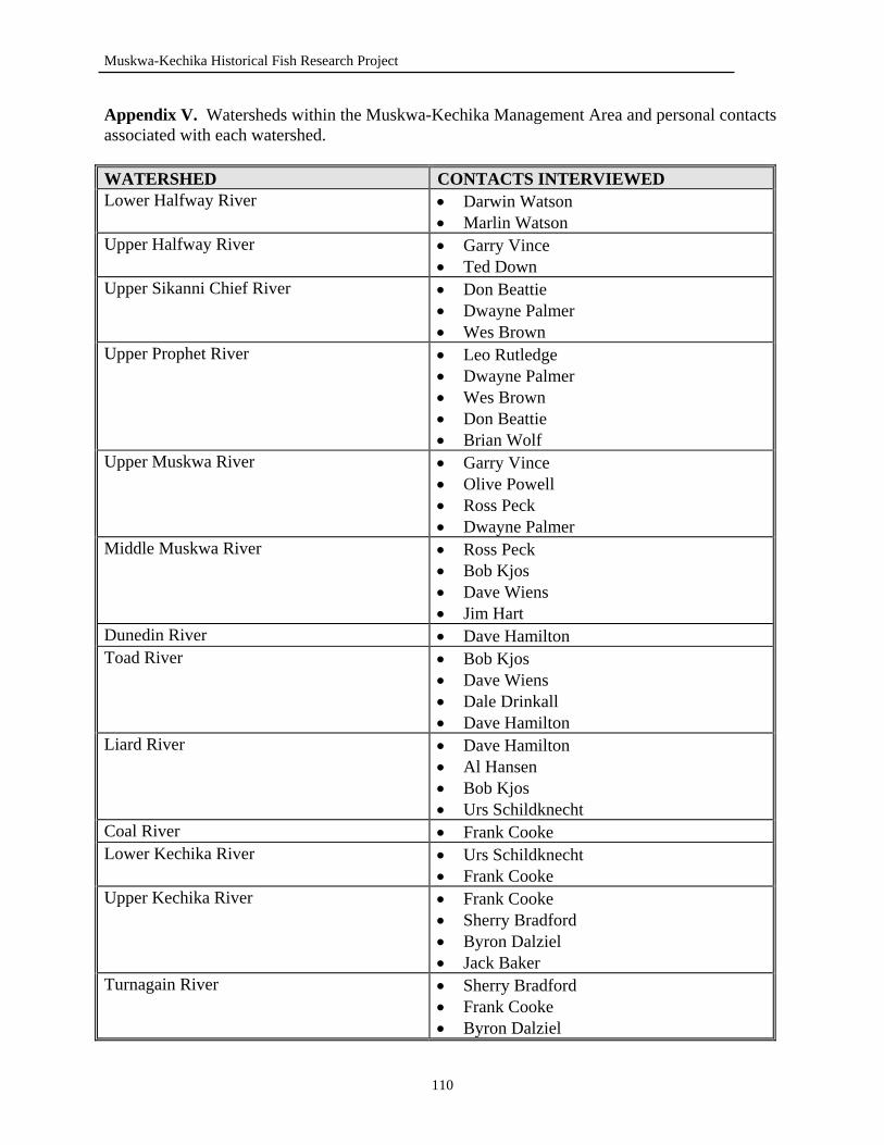
Muskwa-Kechika Historical Fish Research Project
Appendix V. Watersheds within the Muskwa-Kechika Management Area and personal contacts associated with each watershed. WATERSHED CONTACTS INTERVIEWED Lower Halfway River • Darwin Watson
• Marlin Watson Upper Halfway River • Garry Vince
• Ted Down Upper Sikanni Chief River • Don Beattie
• Dwayne Palmer • Wes Brown
Upper Prophet River • Leo Rutledge • Dwayne Palmer • Wes Brown • Don Beattie • Brian Wolf
Upper Muskwa River • Garry Vince • Olive Powell • Ross Peck • Dwayne Palmer
Middle Muskwa River • Ross Peck • Bob Kjos • Dave Wiens • Jim Hart
Dunedin River • Dave Hamilton Toad River • Bob Kjos
• Dave Wiens • Dale Drinkall • Dave Hamilton
Liard River • Dave Hamilton • Al Hansen • Bob Kjos • Urs Schildknecht
Coal River • Frank Cooke Lower Kechika River • Urs Schildknecht
• Frank Cooke Upper Kechika River • Frank Cooke
• Sherry Bradford • Byron Dalziel • Jack Baker
Turnagain River • Sherry Bradford • Frank Cooke • Byron Dalziel
110

Muskwa-Kechika Historical Fish Research Project
• Jim Hart • Rob Woods
Appendix VI. People That Were Unable to be Contacted. NAME TITLE AREA Arnold Churchill Former Guide Outfitter Upper Liard River Area Art Thompson Local Resident Long Mountain Lake & Fishing
Lake Barry Tompkins Guide Outfitter Gathto Creek & Kluachesi Lake Blaine Southwick Guide Outfitter Darwin Cary Guide Outfitter Kechika River Gary Moore Former Guide Outfitter Kechika River Halfway River First Nations
Halfway River
Herb Leake Resident Prophet River John Bedell Resident Chowade River Kaska Dena First Nations Lower Post Katherine Richie Local Resident Halfway River Lynn Ross Former Guide Outfitter Halfway River MacDonald Family Fort Nelson First
Nations Moose Lake
Myles & Sherry Bradford Guide Outfitters Rainbow Lakes, Blue Sheep Lake, Denetiah Lake
Red Saurenson Toad River Area Short Tompkins Pilot Southern Muskwa-Kechika Area Willy Artamenko Guide Tuchodi Lakes
111
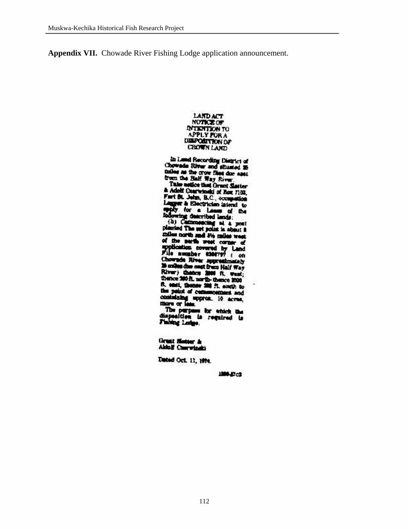
Muskwa-Kechika Historical Fish Research Project
Appendix VII. Chowade River Fishing Lodge application announcement.
112
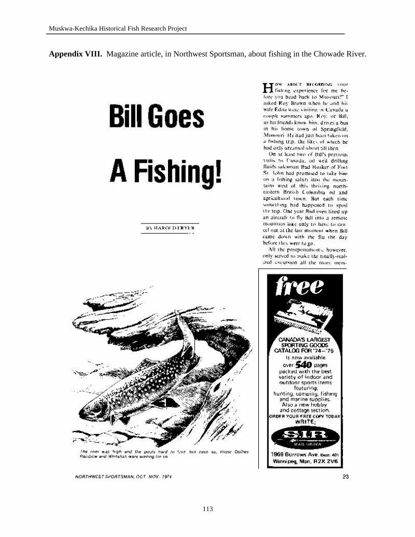
Muskwa-Kechika Historical Fish Research Project
Appendix VIII. Magazine article, in Northwest Sportsman, about fishing in the Chowade River.
113
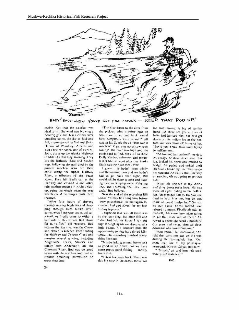
Muskwa-Kechika Historical Fish Research Project Muskwa-Kechika Historical Fish Research Project
114
114
Muskwa-Kechika Historical Fish Research Project
115
Appendix IX. Additional historical literature regarding northeast BC, but not relevant to fisheries in the Muskwa-Kechika Management Area. Brody, H. 1981. Maps and dreams. Vancouver: Douglas & McIntyre Ltd. Kyllo, E. 1973. The peacemakers of Hudson’s Hope. Hudson’s Hope, British
Columbia: Edith Kyllo. Morton, W. L. (editor). 1979. God’s galloping girl: the Peace River diaries of Monica
Storrs, 1929-1931. Vancouver: University of British Columbia Press. Patterson, R. M. 1968. Finlay’s river. Toronto: Macmillan of Canada. Ridington, R. 1990. Little bit know something: stories in a language of anthropology.
Vancouver: Douglas & McIntyre Ltd. Ventress, C., M. Davies, and E. Kyllo. 1973. The peacemakers of North Peace. Fort St.
John, British Columbia: Davies, Ventress and Kyllo. Young, G. F. 1980. The Fort Nelson story: the story of how a town grew out of the
wilderness. Cloverdale, British Columbia: D.W. Friesen & Sons Ltd.