Lumsden Point General Cargo Facility - Citizen Space · LUMSDEN POINT GENERAL CARGO FACILITY...
84
PORT HEDLAND PORT AUTHORITY LUMSDEN POINT GENERAL CARGO FACILITY CONSTRUCTION AND DREDGE MANAGEMENT PLAN Lumsden Point General Cargo Facility Construction and Dredge Management Plan 301012-01660 – DMP-REP-01 25-Sep-13 Level 7, QV1 Building, 250 St. Georges Terrace Perth WA 6000 Australia Telephone: +61 8 9278 8111 Facsimile: +61 8 9278 8110 www.worleyparsons.com ABN 61 001 279 812 © Copyright 2013 WorleyParsons
-
Upload
trinhtuyen -
Category
Documents
-
view
218 -
download
0
Transcript of Lumsden Point General Cargo Facility - Citizen Space · LUMSDEN POINT GENERAL CARGO FACILITY...
PORT HEDLAND PORT AUTHORITY LUMSDEN POINT GENERAL CARGO FACILITY CONSTRUCTION AND DREDGE MANAGEMENT PLAN
Lumsden Point General Cargo
Facility
Construction and Dredge Management Plan
301012-01660 – DMP-REP-01
25-Sep-13
Level 7, QV1 Building,
250 St. Georges Terrace
Perth WA 6000
Australia
Telephone: +61 8 9278 8111
Facsimile: +61 8 9278 8110
www.worleyparsons.com
ABN 61 001 279 812
© Copyright 2013 WorleyParsons
PORT HEDLAND PORT AUTHORITY LUMSDEN POINT GENERAL CARGO FACILITY CONSTRUCTION AND DREDGE MANAGEMENT PLAN
PROJECT 301012-01660 - LUMSDEN POINT GENERAL CARGO FACILITY
REV DESCRIPTION ORIG REVIEW WORLEY-
PARSONS
APPROVAL
DATE CUSTOMER
APPROVAL
DA
TE
A Issued for internal review
A Byron
P Mellor
N/A
30 May 2013 N/A
B Issued for client review
A Byron
P Mellor
P Mellor
16 Jun 2013
0 Issued for use
N Wilson
H Houridis
P Mellor
5 Jul 2013
1 Reissued for use
N Wilson
H Houridis
P Mellor
21 July 2013
2
Reissued for use N Wilson H Houridis P Mellor 25-Sep-13
z:\risk & governance\environment & heritage\shared\e65-r021 lumsden point\3. eia\final referral documents\final oct
2013\rsd_appendix 1_construction and dredge management plan_final.doc
Document No : DMP-REP-01 Page ii
Disclaimer
This report has been prepared on behalf of and for the exclusive use of Port Hedland
Port Authority, and is subject to and issued in accordance with the agreement between
Port Hedland Port Authority and WorleyParsons. WorleyParsons accepts no liability or
responsibility whatsoever for it in respect of any use of or reliance upon this report by
any third party.
Copying this report without the permission of Port Hedland Port Authority or
WorleyParsons is not permitted.
PORT HEDLAND PORT AUTHORITY LUMSDEN POINT GENERAL CARGO FACILITY CONSTRUCTION AND DREDGE MANAGEMENT PLAN
Page iii
CONTENTS
ACRONYMS ................................................................................................................................. 7
1. INTRODUCTION ........................................................................................................... 9
1.1 Project Overview .......................................................................................................... 9
1.2 Objectives .................................................................................................................. 11
1.3 Plan revision and distribution .................................................................................. 11
2. ROLES AND RESPONSIBILITIES ................................................................................... 12
3. LEGISLATIVE REQUIREMENTS AND GUIDELINES ....................................................... 13
3.1 International conventions and agreements ............................................................. 13
3.2 Commonwealth legislation and guidelines ............................................................. 13
3.2.1 Environment Protection and Biodiversity Conservation 1999 (EPBC Act) . 13
3.2.2 Australian and New Zealand guidelines for fresh and marine water quality
(ANZECC/ARMCANZ 2000) ....................................................................................... 13
3.2.3 Other Commonwealth legislation ................................................................ 14
3.3 State legislation ......................................................................................................... 14
3.4 State guidelines ......................................................................................................... 15
3.4.1 Environmental Protection Authority (EPA) Guidance Statement no. 1:
Protection of tropical arid zone mangroves along the Pilbara coastline .............. 15
3.4.2 EPA Environmental Assessment Guideline no.3: Protection of benthic
primary producer habitats In Western Australia’s marine environment (EAG3) . 15
3.4.3 EPA Environmental Assessment Guideline No. 7: Environmental assessment
guideline for marine dredging proposals (EAG7) ................................................... 16
3.4.4 EPA Environmental Protection Bulletin No.14: Guidance for the assessment of
benthic primary producer habitat loss in and around Port Hedland ................... 16
3.4.5 Pilbara water quality guidelines ................................................................... 16
3.4.6 Other guidelines............................................................................................ 16
4. PROJECT DESCRIPTION .............................................................................................. 18
4.1 Dredging activities .................................................................................................... 18
4.2 Wharf development ................................................................................................... 18
4.3 Access corridor .......................................................................................................... 19
4.4 Disposal activities ..................................................................................................... 21
4.5 Pipelines ..................................................................................................................... 22
5. STUDIES AND EXISTING ENVIRONMENT ................................................................... 23
PORT HEDLAND PORT AUTHORITY LUMSDEN POINT GENERAL CARGO FACILITY CONSTRUCTION AND DREDGE MANAGEMENT PLAN
Page iv
5.1 Overview .................................................................................................................... 23
5.2 Key environmental sensitivities ................................................................................ 23
5.3 Marine parks and reserves ....................................................................................... 23
5.4 Previous capital dredging projects .......................................................................... 23
5.5 Physical marine environment ................................................................................... 24
5.5.1 Seabed morphology and geology ................................................................ 24
5.5.2 Bathymetry ..................................................................................................... 25
5.5.3 Hydrodynamics ............................................................................................. 27
5.5.4 Sediment quality ........................................................................................... 27
5.6 Marine water quality ................................................................................................. 28
5.6.1 Physico-chemical ........................................................................................... 28
5.6.2 Chemical ........................................................................................................ 28
5.7 Biological marine environment ................................................................................ 29
5.7.1 Benthic primary producer habitat ................................................................ 29
5.7.2 Marine fauna ................................................................................................. 30
5.7.3 Introduced marine species ........................................................................... 30
5.8 Terrestrial flora and fauna ........................................................................................ 31
5.9 Social and regional environment.............................................................................. 31
5.9.1 Planning context ........................................................................................... 31
5.9.2 Recreation and tourism ................................................................................ 31
5.9.3 Heritage ......................................................................................................... 32
5.9.4 Air quality and noise ..................................................................................... 32
6. IMPACT ASSESSMENT AND MANAGEMENT .............................................................. 34
6.1 Marine water quality ................................................................................................. 34
6.1.1 Predicted impacts ......................................................................................... 34
6.1.2 Management of water quality during dredging and dewatering activities39
6.2 Benthic primary producer habitat ............................................................................ 41
6.2.1 Predicted impacts – direct ............................................................................ 41
6.2.2 Predicted impacts – indirect ......................................................................... 41
6.2.3 Management of BPPH .................................................................................... 44
6.3 Marine fauna .............................................................................................................. 45
PORT HEDLAND PORT AUTHORITY LUMSDEN POINT GENERAL CARGO FACILITY CONSTRUCTION AND DREDGE MANAGEMENT PLAN
Page v
6.3.1 Predicted impacts ......................................................................................... 45
6.3.2 Management of marine fauna ...................................................................... 46
6.4 Introduced marine species ....................................................................................... 48
6.4.1 Predicted impacts ......................................................................................... 48
6.4.2 Management of introduced marine species ................................................ 48
6.5 Terrestrial flora and fauna ........................................................................................ 50
6.5.1 Predicted impacts ......................................................................................... 50
6.5.2 Management of terrestrial flora and fauna ................................................. 51
6.6 Air quality .................................................................................................................. 52
6.6.1 Predicted impacts ......................................................................................... 52
6.6.2 Management of air quality ........................................................................... 53
6.7 Noise and vibration ................................................................................................... 54
6.7.1 Predicted impacts ......................................................................................... 54
6.7.2 Management of noise and vibration ............................................................ 54
6.8 Waste management ................................................................................................... 55
6.8.1 Predicted impacts ......................................................................................... 55
6.8.2 Management of wastes ................................................................................. 56
6.9 Hydrocarbon management ....................................................................................... 57
6.9.1 Predicted impacts ......................................................................................... 57
6.9.2 Management of hydrocarbons ..................................................................... 58
7. MONITORING PROGRAMS AND INSPECTIONS .......................................................... 61
7.1 Tiered Management Framework............................................................................... 61
7.2 Routine Marine Water Quality Monitoring Program ................................................ 62
7.2.1 Development of trigger levels ...................................................................... 62
7.2.2 Monitoring site locations .............................................................................. 66
7.2.3 Frequency ...................................................................................................... 68
7.2.4 Parameters and procedures ......................................................................... 68
7.2.5 Data analysis and reporting ......................................................................... 69
7.3 Subtidal BPP monitoring ........................................................................................... 69
7.3.1 Monitoring site locations .............................................................................. 69
7.3.2 Frequency ...................................................................................................... 71
PORT HEDLAND PORT AUTHORITY LUMSDEN POINT GENERAL CARGO FACILITY CONSTRUCTION AND DREDGE MANAGEMENT PLAN
Page vi
7.3.3 Parameters and procedures ......................................................................... 71
7.3.4 Data analysis ................................................................................................. 72
7.4 Mangrove Health Monitoring Program .................................................................... 72
7.4.1 Development of trigger levels ...................................................................... 73
7.4.2 Monitoring site locations .............................................................................. 73
7.4.3 Frequency ...................................................................................................... 75
7.4.4 Parameters and procedures ......................................................................... 75
7.4.5 Data analysis ................................................................................................. 76
8. REPORTING ................................................................................................................. 77
9. AUDITING ................................................................................................................... 80
10. REFERENCES ............................................................................................................... 81
PORT HEDLAND PORT AUTHORITY LUMSDEN POINT GENERAL CARGO FACILITY CONSTRUCTION AND DREDGE MANAGEMENT PLAN
Page 7
ACRONYMS
ARMCANZ Agriculture and Resource Management Council of Australia and New Zealand
ANZECC Australian and New Zealand Environment Conservation Council
AQIS Australian Quarantine Information System
BPP Benthic Primary Producer
BPPH Benthic Primary Producer Habitat
BHPBIO BHP Billiton Iron Ore
CRIMP Centre for Research on Introduced Marine Pests
CD Chart Datum
CAMBA China-Australia Migratory Bird Agreement
CDMP Construction and Dredge Management Plan
CNMP Construction Noise Management Plan
CLGs Cumulative Loss Guidelines
DEC Department of Environment and Conservation
DER Department of Environment Regulation
DoE Department of Environment
DPW Department of Parks and Wildlife
DMMA Dredge Material Management Area
EAG Environmental Assessment Guideline
EIA Environmental Impact Assessment
EMP Environmental Management Plan
EPBC Act Environmental Protection and Biodiversity Act 1999 (Cwlth)
EPA Environmental Protection Authority
FTP File Transfer Protocol
FIC Finucane Island
FMG Fortescue Metal Group
ha Hectare
IMO International Maritime Organisation
JAMBA Japan-Australia Migratory Bird Agreement
PORT HEDLAND PORT AUTHORITY LUMSDEN POINT GENERAL CARGO FACILITY CONSTRUCTION AND DREDGE MANAGEMENT PLAN
Page 8
KPIs Key Performance Indicators
LAI Leaf Area Index
LAU Local Assessment Unit
MGA Map Grid Australia
MPL Marapikurrinya Pty Ltd
NOAA National Oceanic and Atmospheric Administration
NTU Nephelometric Turbidity Units
NOx Nitrate and Nitrite
P Phosphorous
PCBs Polychlorinated Biphenyls
PAHs Polycyclic Aromatic Hydrocarbons
PHPA Port Hedland Port Authority
ROKAMBA Republic of Korea-Australia Bird Agreement
SKM Sinclair Knight Merz
SWC South West Creek
SEC South East Creek
SRC Stingray Creek
SOx Sulfates and Sulfides
SSC Suspended Sediment Concentrations
TMF Tiered Management Framework
TKN Total Kjeldahl Nitrogen
TOC Total Organic Carbon
TPH Total Petroleum Hydrocarbons
TSS Total Suspended Solids
VOCs Volatile Organic Compounds
WA Western Australia
WAPC Western Australia Planning Commission
PORT HEDLAND PORT AUTHORITY LUMSDEN POINT GENERAL CARGO FACILITY CONSTRUCTION AND DREDGE MANAGEMENT PLAN
Page 9
1. INTRODUCTION
1.1 Project Overview
The Port Hedland Port Authority (PHPA) has identified Lumsden Point as a potential site to
develop a General Cargo Facility both to alleviate trade growth pressures on berths 1, 2 and
3 and to accommodate potential marine supply trades supporting the offshore oil and gas
and other industries.
The facility will focus primarily on the import of general cargo goods such as containers,
cement and ammonium nitrate, and is being developed to ease congestion at the port’s
current general cargo berths in response to significant growth associated with expansion in
the iron ore mining sector.
The proposed works the Lumsden Point General Cargo Facility (the project) will include:
two Handymax berths totalling a length of 500 m;
dredging of up to -13.5 m CD for the berth pocket;
dredging of up to -12.0 m CD for the access channel;
causeway access along an existing land-based connection;
an area of land immediately behind the berths; and
disposal of dredge spoil onshore to an approved Dredge Material Management Area
(DMMA).
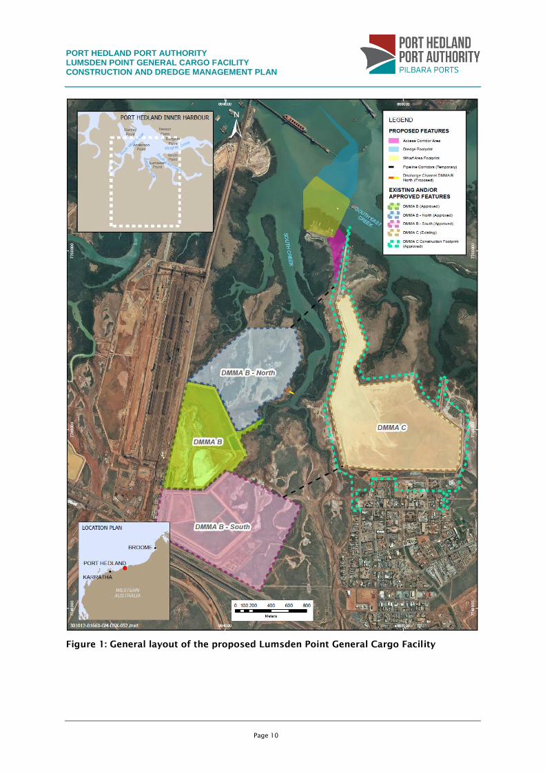
A general layout of the Lumsden Point General Cargo Facility is provided in Figure 1.
The project is located at Lumsden Point, which is situated at the junction of South East
Creek and South Creek within Port Hedland port’s inner harbour (Figure 1). It is located
approximately 5 km south of the Port Hedland townsite and adjoins the existing light
industrial area of Wedgefield. The FMG Anderson Point port facility, iron stockpile and
offloading facilities are to the west of the project and DMMAs B and C are located to the
south.
PORT HEDLAND PORT AUTHORITY LUMSDEN POINT GENERAL CARGO FACILITY CONSTRUCTION AND DREDGE MANAGEMENT PLAN
Page 10
Figure 1: General layout of the proposed Lumsden Point General Cargo Facility
PORT HEDLAND PORT AUTHORITY LUMSDEN POINT GENERAL CARGO FACILITY CONSTRUCTION AND DREDGE MANAGEMENT PLAN
Page 11
1.2 Objectives
The objective of this Construction and Dredging Management Plan (CDMP) is to provide a
framework for the environmental management of construction and dredging activities. It is
designed to minimise the environmental risks to a level that is as low as reasonably
practical.
This CDMP presents the potential impacts, management measures, objectives and actions
with the associated key performance indicators (KPIs) to be implemented throughout the
project. The plan outlines the proposed monitoring and inspection programs to assess any
environmental impacts of the Lumsden Point General Cargo Facility and allows for the
effective and timely implementation of contingency measures, if required.
1.3 Plan revision and distribution
If a significant change in the duration or nature of the construction and dredging works
occurs, this CDMP will be reviewed. The review will include a reassessment of the
environmental risks posed by the works and the corresponding management strategies.
If the CDMP becomes a condition of any statutory approval, any significant revision to the
CDMP will need to be approved by the relevant regulatory authorities.
PORT HEDLAND PORT AUTHORITY LUMSDEN POINT GENERAL CARGO FACILITY CONSTRUCTION AND DREDGE MANAGEMENT PLAN
Page 12
2. ROLES AND RESPONSIBILITIES
The PHPA is responsible for implementing the proposal and adhering to the commitments
made within this CDMP. Table 1 identifies the responsibilities associated with the key
management positions during dredging activities.
Table 1: Roles and Responsibilities
Element Description
Project Manager Overall responsibility for implementation of the CDMP.
Overall responsibility for compliance with statutory
requirements.
Construction Manager Day-to-day implementation of the CDMP.
Directs construction contractors with respect to environmental
controls.
Day-to-day coordination of the Project.
Ensures adequate training of all staff within area of
responsibility.
Dredging Contractor –
Project Manager
Prepares and implements an EMP in accordance with the
requirements of this CDMP and the existing PHPA EMP.
Implements the management actions as required.
Ensures adequate training of all staff within area of
responsibility.
Ensures all equipment is adequately maintained and correctly
operated.
Environmental
Coordinator
Provides advice on dredging, dredge material management and
construction-related environmental issues.
Oversees implementation of environmental controls,
monitoring programs, inspections and audits.
Completes compliance reporting requirements.
Coordinates the training and induction process.
Implements the environmental monitoring programs and
inspections.
Prepares environmental monitoring reports.
Provides advice with respect to environmental issues as
required.
All persons involved
in project
Comply with the requirements of this CDMP.
Comply with all legal requirements under the approvals
documents and relevant Acts.
Exercise a duty of care to the environment at all times.
Report all environmental incidents.
PORT HEDLAND PORT AUTHORITY LUMSDEN POINT GENERAL CARGO FACILITY CONSTRUCTION AND DREDGE MANAGEMENT PLAN
Page 13
3. LEGISLATIVE REQUIREMENTS AND GUIDELINES
3.1 International conventions and agreements
International agreements applicable to this CDMP may include, but are not limited to:
The 1996 London Protocol to the Convention on the Prevention of Marine Pollution by
Dumping of Wastes and Other Matter, 1972 (ratified by Australia in 2000);
The International convention for the Prevention of Pollution from Ships, 1973, as
modified by the Protocol of 1978 (MARPOL 73/78) (International Maritime
Organisation);
The International Convention for the Control and Management of Ships’ Ballast Water
and Sediments (International Maritime Organisation (IMO);
United Nations Convention of the Law of the Sea;
ANZECC Code of Practice for Antifouling and In-water Cleaning and Maintenance;
The Convention on the Conservation of Migratory Species of Wild Animals (Secretariat
of the Convention for the Conservation of Migratory Species of Wild Animals 1979);
Japan-Australia Migratory Bird Agreement (JAMBA), 1974;
China-Australia Migratory Bird Agreement (CAMBA), 1986; and
Republic of Korea-Australia Bird Agreement (ROKAMBA), 2002.
3.2 Commonwealth legislation and guidelines
3.2.1 Environment Protection and Biodiversity Conservation 1999
(EPBC Act)
The EPBC Act establishes a process for the assessment and approval of proposed actions
that are likely to have a significant impact on matters of national environmental significance
or on Commonwealth land. Possible impacts on endangered species or listed migratory
species may trigger the Act.
The Lumsden Point General Cargo Facility is not expected to significantly impact on any
matters of national environmental significance and therefore has not been referred to the
Commonwealth Environment Minister for approval under the EPBC Act.
3.2.2 Australian and New Zealand guidelines for fresh and marine
water quality (ANZECC/ARMCANZ 2000)
The Australian and New Zealand guidelines for fresh and marine water quality
(ANZECC/ARMCANZ 2000) advise on activities that may affect water quality. These
guidelines provide criteria for establishing levels of ecological protection for marine areas
based on existing levels of disturbance, but also recommend deferring to locally developed
consultative guidelines where they exist and are relevant.
PORT HEDLAND PORT AUTHORITY LUMSDEN POINT GENERAL CARGO FACILITY CONSTRUCTION AND DREDGE MANAGEMENT PLAN
Page 14
3.2.3 Other Commonwealth legislation
Other applicable Commonwealth legislation and guidelines include, but are not limited to,
the following Acts, Regulations (and relevant amendments):
Australian Quarantine Regulations 2000;
Dangerous Substances Act 2004;
Fisheries Act 1952;
Marine Act 1982;
National Environment Protection Council Act 1994;
National Environmental Protection Measures (Implementation) Act 1998;
Navigable Waters Regulations 1958;
Port and Harbour Regulations 1966;
Protection of the Seas (Prevention of Pollution from Ships) Act 1983;
Australian Ballast Water Management Requirements 2001;
Quarantine Act 1908;
Seas and Submerged Lands Act 1973;
National Strategy for Ecologically Sustainable Development (Commonwealth
Government of Australia 1992b);
National Water Quality Management Strategy (Commonwealth Government of Australia
1992c);
Intergovernmental Agreement on the Environment (Commonwealth Government of
Australia 1992a); and
National Strategy for Conservation of Australia’s Biological Diversity (Commonwealth
of Australia 1996).
3.3 State legislation
The key Western Australian legislation and regulations relevant to the construction of the
Lumsden Point General Cargo Facility includes:
Environmental Protection Act 1986; and
Environmental Protection Regulations 1987.
Other legislation and regulations that may also apply to the project include:
Aboriginal Heritage Act 1972;
Environmental Protection (Clearing of Native Vegetation) Regulations 2004;
Environmental Protection (Noise) Regulations 1997;
Fish Resources Management Act 1994;
PORT HEDLAND PORT AUTHORITY LUMSDEN POINT GENERAL CARGO FACILITY CONSTRUCTION AND DREDGE MANAGEMENT PLAN
Page 15
Main Roads Act 1930;
Marine and Harbours Act 1981;
Native Title (State Provisions) Act 1999;
Pollution of Waters by Oil and Noxious Substances Act 1987;
Port Authorities Act 1999;
Shipping and Pilotage Act 1987;
Western Australian Marine Act 1982; and
Wildlife Conservation Act 1950.
3.4 State guidelines
Key state legislation and guidelines applicable to the proposed Lumsden Point General
Cargo Facility are discussed below.
3.4.1 Environmental Protection Authority (EPA) Guidance
Statement no. 1: Protection of tropical arid zone mangroves
along the Pilbara coastline
Guidance Statement No. 1(EPA 2001) categorises Port Hedland as being covered by
‘Management Area 4: Other mangrove areas — inside designated industrial areas and
associated port areas’. The mangrove areas specified are defined as occurring inside areas
that have been designated as industrial areas, associated ports or other development and
not covered by EAG3.
The EPA’s operational objective for ‘Management Area 4’ is that the impacts of development
on mangrove habitat and their ecological function in these areas should be reduced to the
minimum practicable level.
3.4.2 EPA Environmental Assessment Guideline no.3: Protection of
benthic primary producer habitats In Western Australia’s
marine environment (EAG3)
EAG3 (EPA 2009a) specifically applies to development projects that are predicted to result in
irreversible loss of or serious damage to marine benthic primary producer habitat (BPPH) in
state waters. This guideline defines and recognises the fundamental ecological importance
of benthic primary producers (BPP) and their habitats, and provides a framework for
assessing environmental impacts on BPPH. The risk-based spatial assessment framework
provides the means to evaluate cumulative losses (i.e. historical and proposed losses) of
BPPH within defined sub-ecosystem areas called local assessment units (LAUs).
Cumulative loss guidelines (CLGs) are based on six categories of marine ecological
protection, which the proponent must apply in the assessment of ecological risks to BPPH
associated with a proposal. The Port Hedland industrial unit covers an area of 4,977 ha and
has been termed ‘Category F’ under EAG3 (EPA 2009a; EPA 2009c). However, a more recent
PORT HEDLAND PORT AUTHORITY LUMSDEN POINT GENERAL CARGO FACILITY CONSTRUCTION AND DREDGE MANAGEMENT PLAN
Page 16
assessment undertaken as part of the Outer Harbour Development proposal suggests that
overall loss from the PHLAU may be less than the 10% cumulative loss guideline (EPA 2012).
3.4.3 EPA Environmental Assessment Guideline No. 7:
Environmental assessment guideline for marine dredging
proposals (EAG7)
EAG 7 (EPA 2011a) specifically relates to ensuring that the predicted extent, severity and
duration of impacts to benthic habitats associated with significant dredging activities, which
are subject to formal environmental impact assessment by the EPA, are presented in a clear
and consistent manner. The statement provides guidance on the identification of impacts
associated with dredging, using a specified approach to identify areas of high impact,
moderate impact and zone of influence through the collection of baseline data. The
statement also recommends the development of predictive models to help identify the
potential extent of sediment plumes generated as a consequence of dredging and disposal
activities.
3.4.4 EPA Environmental Protection Bulletin No.14: Guidance for
the assessment of benthic primary producer habitat loss in
and around Port Hedland
The Office of the EPA has confirmed that different proponents have defined different LAUs
for assessing cumulative losses of BPPH within the inner Port Hedland port area via spatial
analysis (EPA 2011b). Variation in LAU boundaries among proposals leads to inconsistent
application of EAG3 by proponents, which flow through to the EIA process undertaken by
the EPA. The overarching aim of this document is to establish a clear and common starting
point for the evaluation and accounting of BPPH loss in the inner Port Hedland port area.
3.4.5 Pilbara water quality guidelines
The Pilbara environmental values and environmental quality objectives (DoE 2006) specify
various environmental values and quality objectives to guide the management of coastal
water quality in the region. These values and objectives are presented in Table 3 of the
guidelines along with the applicable environmental quality criteria and references to the
controls that will be implemented.
3.4.6 Other guidelines
Other applicable guidelines include, but are not limited to the following:
Environmental Assessment Guideline 1: Environmental Assessment Guideline for
Defining the Key Characteristics of a Proposal Environmental Protection Act 1986
(EAG1) (EPA 2012);
Environmental Assessment Guideline 6: Revised Environmental Assessment Guideline
for Timelines for environmental impact assessment of proposals (EAG6) (EPA 2013);
Environmental Assessment Guideline 8: Environmental Assessment Guideline for
Environmental factors and objectives (EAG8)(EPA 2013);
PORT HEDLAND PORT AUTHORITY LUMSDEN POINT GENERAL CARGO FACILITY CONSTRUCTION AND DREDGE MANAGEMENT PLAN
Page 17
Guidance statement 8: Environmental noise (draft) (EPA 2007);
Guidance statement 41: Assessment of Aboriginal heritage (EPA 2004); and
Guidance statement 55: Implementing best practice in proposals submitted to the
environmental impact assessment process (EPA 2003).
PORT HEDLAND PORT AUTHORITY LUMSDEN POINT GENERAL CARGO FACILITY CONSTRUCTION AND DREDGE MANAGEMENT PLAN
Page 18
4. PROJECT DESCRIPTION
4.1 Dredging activities
The Lumsden Point General Cargo Facility involves dredging of the intertidal and subtidal
areas of the inner port area of Port Hedland port adjacent to the north of Lumsden Point to
establish an access channel, swing basin and berthing pocket. The dredging footprint occurs
in an area of shallow bathymetry, ranging from -0 m CD to -10.0 m CD. The site is partially
sheltered from wave energy but is subject to high-velocity tidal flow.
The proposed dredging will comprise the following components:
access channel dredged to a maximum depth of -12.0 m CD;
berth pockets dredged to a maximum depth of -13.5 m CD;
swing basin dredged to a depth of -12.0 m with a diameter of 304 m; and
ancillary seabed disturbance associated with dredging, including dredge anchor and
spud placement.
Up to 2 Mm3
of material will need to be dredged to achieve the required design depths for
safe navigation. The volume of material to be dredged includes over-dredging of 0.5 m
below the maximum design depth in each dredge pocket. Maximum depth of batters has
also been used in finalising a maximum dredge volume and rounded up for contingency
purposes. The dredging activities are expected to be conducted over a period of
approximately 20 weeks based on a dredge volume rate of 1000 m3
/hour. Dredging is
proposed to be undertaken using a single cutter suction dredge.
The indicative extent of dredging required for safe navigation of vessels using the proposed
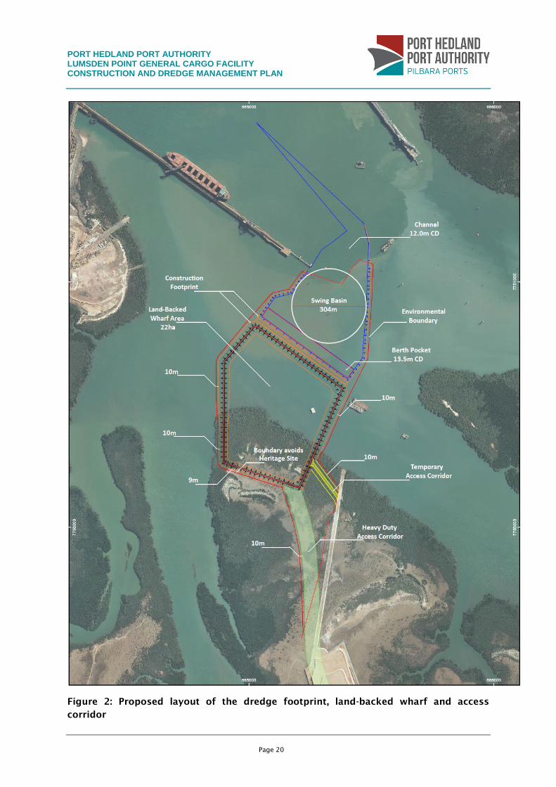
Lumsden Point General Cargo Facility, including the coordinates of the proposed
disturbance footprint, is shown in Figure 2.
Dredge material will be transferred via pipelines. The material will consist of both coarse
and fine material. While the coarse material will settle out of suspension rapidly and
constitute valuable material for reuse onshore for land-backed wharf area, the fine material
will either be placed in DMMA C or as a final option be transferred into DMMA B, B North
and/or B South.
4.2 Wharf development
The development of the land-backed wharf (Figure 2) located immediately behind the two
Handymax berths will require an area of 26.31 ha to be reclaimed. Material for reclamation
of this area will be sourced from dredge material within the proposed dredge footprint if
considered suitable for reclamation purposes. If the dredge material is unsuitable, then
material will be sourced offsite from a location yet to be determined. It is estimated that 28,
663 m3
of material will be required for reclamation of the area.
The wharf will be constructed through the development of a bund wall constructed from
rock sourced offsite. Once the rock wall has been completed, dredge material will be placed
PORT HEDLAND PORT AUTHORITY LUMSDEN POINT GENERAL CARGO FACILITY CONSTRUCTION AND DREDGE MANAGEMENT PLAN
Page 19
within the bund wall. Following completion of the reclamation area, the wharf structure will
be constructed. The wharf will be a deck-on-piles structure. Piles will be driven into the
substrate, the formwork established and headstocks/decks poured and set onsite.
4.3 Access corridor
The proposed access corridor will comprise two separate causeway developments between
the land-backed wharf and the onshore facilities located within the DMMA C construction
boundary. A temporary access area will be developed to provide sufficient access for
construction vehicles to move between both areas during construction, while a second
permanent corridor will be developed for access to and from the wharf area during
operation. Figure 2 provides a map showing the area in which the causeways will be located.
At present the exact configuration of the two access corridor routes is undecided, however
the footprint will not extend outside the existing outer boundaries displayed in Figure 2.
PORT HEDLAND PORT AUTHORITY LUMSDEN POINT GENERAL CARGO FACILITY CONSTRUCTION AND DREDGE MANAGEMENT PLAN
Page 20
Figure 2: Proposed layout of the dredge footprint, land-backed wharf and access
corridor
PORT HEDLAND PORT AUTHORITY LUMSDEN POINT GENERAL CARGO FACILITY CONSTRUCTION AND DREDGE MANAGEMENT PLAN
Page 21
4.4 Disposal activities
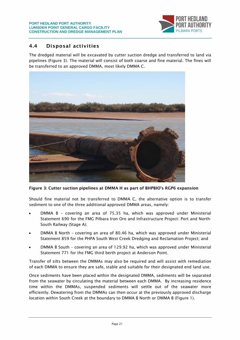
The dredged material will be excavated by cutter suction dredge and transferred to land via
pipelines (Figure 3). The material will consist of both coarse and fine material. The fines will
be transferred to an approved DMMA, most likely DMMA C.
Figure 3: Cutter suction pipelines at DMMA H as part of BHPBIO’s RGP6 expansion
Should fine material not be transferred to DMMA C, the alternative option is to transfer
sediment to one of the three additional approved DMMA areas, namely:
DMMA B – covering an area of 75.35 ha, which was approved under Ministerial
Statement 690 for the FMG Pilbara Iron Ore and Infrastructure Project: Port and North-
South Railway (Stage A);
DMMA B North – covering an area of 80.46 ha, which was approved under Ministerial
Statement 859 for the PHPA South West Creek Dredging and Reclamation Project; and
DMMA B South – covering an area of 129.92 ha, which was approved under Ministerial
Statement 771 for the FMG third berth project at Anderson Point.
Transfer of silts between the DMMAs may also be required and will assist with remediation
of each DMMA to ensure they are safe, stable and suitable for their designated end land use.
Once sediments have been placed within the designated DMMA, sediments will be separated
from the seawater by circulating the material between each DMMA. By increasing residence
time within the DMMAs, suspended sediments will settle out of the seawater more
efficiently. Dewatering from the DMMAs can then occur at the previously approved discharge
location within South Creek at the boundary to DMMA B North or DMMA B (Figure 1).
PORT HEDLAND PORT AUTHORITY LUMSDEN POINT GENERAL CARGO FACILITY CONSTRUCTION AND DREDGE MANAGEMENT PLAN
Page 22
4.5 Pipelines
During dredging activities, dredge material may need to be transferred between DMMAs to
reduce water content within the material and/or manage the volume of material between
DMMAs. At this stage it is likely that pipelines to transfer material between DMMAs will not
be required. However, should pipelines be required, a 5m wide corridor will be established
between the wharf area and DMMA B North and/or DMMA C and DMMA B (Figure 1).
PORT HEDLAND PORT AUTHORITY LUMSDEN POINT GENERAL CARGO FACILITY CONSTRUCTION AND DREDGE MANAGEMENT PLAN
Page 23
5. STUDIES AND EXISTING ENVIRONMENT
5.1 Overview
This section describes the existing marine environment in the Lumsden Point General Cargo
Facility disturbance footprint and Port Hedland inner harbour. It summarises information
collected by desktop review, in addition to subtidal and marine investigations undertaken
for the proposed Lumsden Point General Cargo Facility and for previous projects undertaken
within the inner harbour adjacent to the proposed disturbance footprint.
5.2 Key environmental sensitivities
The key environmental sensitivities that could potentially be affected by the proposed
construction activities include:
marine water quality; and
benthic primary producer habitat.
5.3 Marine parks and reserves
There are no marine parks or reserves in the vicinity of Port Hedland. The proposed Dampier
Archipelago Marine Park is the nearest but is 225 km to the west, and the recently approved
Eighty Mile Beach is 250 km to the north. Both marine parks are well outside the predicted
zone of influence of proposed dredging activities.
5.4 Previous capital dredging projects
Several dredging projects have been undertaken adjacent to the proposed disturbance
footprint and more widely within Port Hedland inner harbour. These include capital dredging
at Anderson Point, Nelson Point and within South West Creek. The history of capital
dredging in Port Hedland since 1977 is summarised in Table 2.
Table 2: Approved dredge volumes for capital dredging projects undertaken in Port
Hedland inner harbour
Year Dredge volume
(m3
)
Proponent
1986 13,600,000 BHPBIO
2002 460,000 BHPBIO
2006-07 5,000,000 FMG
2008 3,400,000 FMG
2009 3,900,000 BHPBIO
2010 6,000,000 BHPBIO
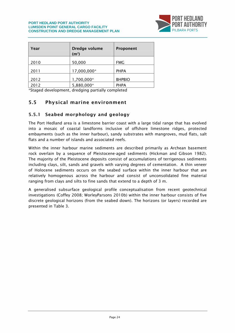
PORT HEDLAND PORT AUTHORITY LUMSDEN POINT GENERAL CARGO FACILITY CONSTRUCTION AND DREDGE MANAGEMENT PLAN
Page 24
Year Dredge volume
(m3
)
Proponent
2010 50,000 FMG
2011 17,000,000* PHPA
2012 1,700,000* BHPBIO
2012 5,880,000* PHPA
*Staged development, dredging partially completed
5.5 Physical marine environment
5.5.1 Seabed morphology and geology
The Port Hedland area is a limestone barrier coast with a large tidal range that has evolved
into a mosaic of coastal landforms inclusive of offshore limestone ridges, protected
embayments (such as the inner harbour), sandy substrates with mangroves, mud flats, salt
flats and a number of islands and associated reefs.
Within the inner harbour marine sediments are described primarily as Archean basement
rock overlain by a sequence of Pleistocene-aged sediments (Hickman and Gibson 1982).
The majority of the Pleistocene deposits consist of accumulations of terrigenous sediments
including clays, silt, sands and gravels with varying degrees of cementation. A thin veneer
of Holocene sediments occurs on the seabed surface within the inner harbour that are
relatively homogenous across the harbour and consist of unconsolidated fine material
ranging from clays and silts to fine sands that extend to a depth of 3 m.
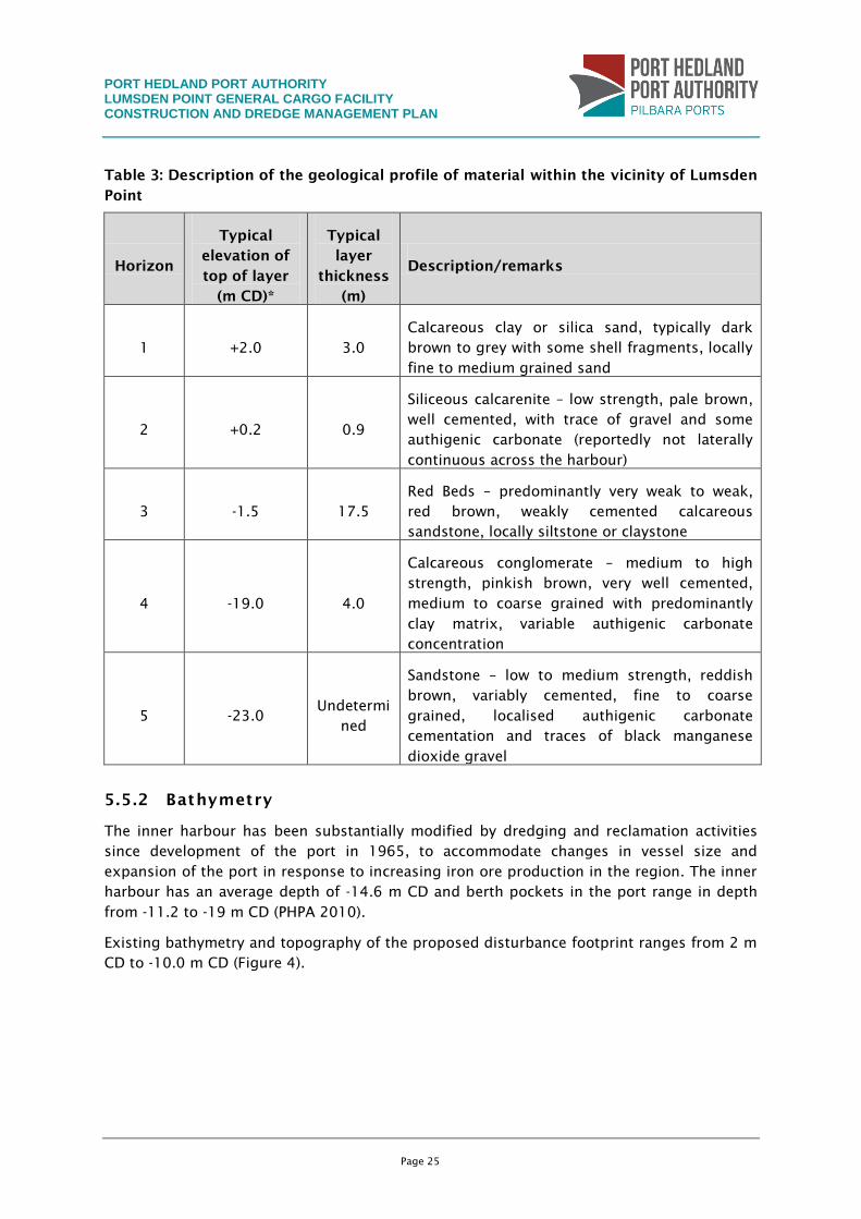
A generalised subsurface geological profile conceptualisation from recent geotechnical
investigations (Coffey 2008; WorleyParsons 2010b) within the inner harbour consists of five
discrete geological horizons (from the seabed down). The horizons (or layers) recorded are
presented in Table 3.
PORT HEDLAND PORT AUTHORITY LUMSDEN POINT GENERAL CARGO FACILITY CONSTRUCTION AND DREDGE MANAGEMENT PLAN
Page 25
Table 3: Description of the geological profile of material within the vicinity of Lumsden
Point
Horizon
Typical
elevation of
top of layer
(m CD)*
Typical
layer
thickness
(m)
Description/remarks
1 +2.0 3.0
Calcareous clay or silica sand, typically dark
brown to grey with some shell fragments, locally
fine to medium grained sand
2 +0.2 0.9
Siliceous calcarenite – low strength, pale brown,
well cemented, with trace of gravel and some
authigenic carbonate (reportedly not laterally
continuous across the harbour)
3 -1.5 17.5
Red Beds – predominantly very weak to weak,
red brown, weakly cemented calcareous
sandstone, locally siltstone or claystone
4 -19.0 4.0
Calcareous conglomerate – medium to high
strength, pinkish brown, very well cemented,
medium to coarse grained with predominantly
clay matrix, variable authigenic carbonate
concentration
5 -23.0 Undetermi
ned
Sandstone – low to medium strength, reddish
brown, variably cemented, fine to coarse
grained, localised authigenic carbonate
cementation and traces of black manganese
dioxide gravel
5.5.2 Bathymetry
The inner harbour has been substantially modified by dredging and reclamation activities
since development of the port in 1965, to accommodate changes in vessel size and
expansion of the port in response to increasing iron ore production in the region. The inner
harbour has an average depth of -14.6 m CD and berth pockets in the port range in depth
from -11.2 to -19 m CD (PHPA 2010).
Existing bathymetry and topography of the proposed disturbance footprint ranges from 2 m
CD to -10.0 m CD (Figure 4).

PORT HEDLAND PORT AUTHORITY LUMSDEN POINT GENERAL CARGO FACILITY CONSTRUCTION AND DREDGE MANAGEMENT PLAN
Page 26
Figure 4: Existing bathymetry within and adjacent to the Project footprint
PORT HEDLAND PORT AUTHORITY LUMSDEN POINT GENERAL CARGO FACILITY CONSTRUCTION AND DREDGE MANAGEMENT PLAN
Page 27
5.5.3 Hydrodynamics
Currents within Port Hedland are dominated by tidal flows due to a combination of the large
tidal range that exists in the area; the narrow entrance to the port; shelter from wind and
swell-driven wave currents provided by Finucane Island; and shallow, narrow creek systems
that flow into the port area. The highest astronomical tide is approximately 8 m CD, with
tides typically ranging from 1.5 m CD during neaps to 5.8 m CD at springs, and are
predominantly semi-diurnal.
During neap tidal conditions, waters within the port are generally well mixed. Even so, some
areas experience stratification due to lower current velocities and reduced mixing efficiency.
During spring tides increased current velocity and movement of water in a counter-clockwise
direction within the turning basin causes reduced mixing within some of the deeper areas of
the turning basin (Halpern Glick Maunsell 1997). The natural littoral drift process moves
sediment from west to east and the natural current direction in the local area is north-
westerly to south-easterly (GHD 2007).
5.5.4 Sediment quality
Port Hedland is located within the North West Shelf marine area. The sediments of the North
West Shelf typically comprise sands to sandy muds inshore, grading to coarse carbonate
sands and gravels offshore (McLoughlin and Young 1985; Dix 1989; Semeniuk 1993).
Inshore, sediment grain size and composition, which is typically linked to wave energy and
proximity to large rivers, contains finer, lower calcium carbonate sediments naturally
occurring within sheltered bays and in mangrove creeks (Semeniuk, Chalmer et al. 1982).
Seabed sediment grain size in the inner port area and creek systems that feed into the inner
port are highly variable due to the presence of strong tidal currents, periodic cyclones, the
protected embayment and sediment-producing organisms such as coral reefs (Talbot and
Creagh 1985).
Extensive data has previously been collected within Port Hedland to define chemical
sediment quality characteristics and potential risks associated with dredging, offshore
disposal, land-based disposal and reclamation activities in the general area. A detailed
sediment quality assessment was undertaken in the Project dredge footprint. Contaminant
concentrations were analysed for a suite of parameters including metals, TPH, PAHs, PCBs,
organochlorine pesticides and organophosphate pesticides from samples collected from five
boreholes and nine surface samples. All samples were found to have concentrations below
adopted guideline levels except for nickel and chromium. These two metals have both been
found to occur at naturally elevated concentrations throughout the Port Hedland region (DEC
2006).
Acid sulfate soil (ASS) tests were also undertaken on sediments located within the proposed
dredge footprint. The potential for ASS was found in three of the tested samples collected
from surface sediments, however due to the increased neutralising capacity from the
calcareous materials, no samples exceeded the DEC (2013) Action Criteria for net acidity –
requiring no active ASS management measures to be implemented.
PORT HEDLAND PORT AUTHORITY LUMSDEN POINT GENERAL CARGO FACILITY CONSTRUCTION AND DREDGE MANAGEMENT PLAN
Page 28
5.6 Marine water quality
In response to environmental management requirements for dredging and reclamation
projects, extensive baseline and conformance water quality monitoring has been undertaken
in recent years within the port limits. These are summarised in sections 5.6.1 and 5.6.2.
5.6.1 Physico-chemical
Due to extensive operational and construction activities occurring on a continuous basis
within the inner port area, water quality data that can be considered ‘baseline’ can be
difficult to collect. Due to the port’s rapid expansion in recent years, water quality
throughout the inner port has been affected by dredging and dewatering activities – causing
changes to physico-chemical water quality.
The most recent relevant study undertaken to define baseline physico-chemical water quality
was undertaken in 2012 for the Stingray Creek Cyclone Mooring Facility (WorleyParsons
2012c) for the inner harbour, and during the South West Creek Dredging and Reclamation
Project for the discharge sites in the upper creeks (WorleyParsons 2011). Physico-chemical
water quality data was collected from five sites located within the inner harbour to
determine baseline conditions. Data was collected between December 2010 and March 2012
between dredging activities.
Turbidity was generally found to be higher in creeks compared with the more exposed sites
located at the mouths of the creeks in the inner harbour, most likely due to an increase in
fine sediments and reduced flushing from the open ocean. Sites located adjacent to the
inner harbour displayed median turbidity of <7 NTU, while sites located upstream displayed
median turbidity of >9 NTU.
The pH was found to be similar between sites located in or adjacent to the operating port
area, while pH at sites located within the creeks was slightly lower. Within each site pH was
found to show low variation.
Due to the shallow bathymetry observed at each site, temperature was found to vary
depending on air temperature variation as a consequence of seasonal change. Median
temperatures at each site ranged between 21.21 o
C and 31.63 o
C. Temperatures were
generally high due to the sub-tropical climate that is found in this region of Australia.
Higher dissolved oxygen concentrations were found in areas exposed to the open ocean
compared with sites located within the creeks.
5.6.2 Chemical
Baseline water quality investigations undertaken in South West Creek as part of PHPA’s
dredging and reclamation project (WorleyParsons 2010f) found that all metals reported
concentrations below (ANZECC/ARMCANZ 2000) for 99% ecological protection, with the
exception of copper and cobalt due to the laboratory limit of reporting being above the
(ANZECC/ARMCANZ 2000) guidelines. Nutrients and hydrocarbons in the same study were
below the 99% level of ecological protection guidelines at the monitored sites.
Baseline water quality investigations for RGP5 and RGP6 were undertaken between August
2008 and December 2009. All parameters reported concentrations below ANZECC &
PORT HEDLAND PORT AUTHORITY LUMSDEN POINT GENERAL CARGO FACILITY CONSTRUCTION AND DREDGE MANAGEMENT PLAN
Page 29
ARMCANZ guidelines (2000) for 99% ecological protection, with the exception of copper,
cobalt zinc and nickel. Copper, zinc and cobalt exceeded the 95% species protection
(ANZECC/ARMCANZ 2000) trigger values and nickel exceeded the 99% species protection
(ANZECC/ARMCANZ 2000) trigger value (BHPBIO 2010).
More recently, as part of the South West Creek dredging project, nickel concentrations in
return water were monitored during dewatering activities. The monitoring program
measured intermittent exceedances in of the trigger value for nickel (7 µg/L) however
similar exceedances were noted in reference areas unaffected by dredging (WorleyParsons
2012b)
In the High Ecological Protection Area (HEPA) a 99% species protection is adopted and in the
Moderate Ecological Protection Area (MEPA) a 90% species protection is adopted. The species
protection values for certain contaminants are designated according to the ecological
protection area (ANZECC/ARMCANZ 2000).
5.7 Biological marine environment
5.7.1 Benthic primary producer habitat
The marine habitats found in Port Hedland are characteristic of those found along the arid
coastlines of the Pilbara. Typically, dense stands of mangroves occupy areas within the
intertidal zone, where tidal inundation is sufficiently frequent to maintain adequate
sediment water content and levels of salinity for colonisation by mangroves. As distance
from the shoreline increases, the height and cover of mangrove vegetation decreases, giving
way to saltmarsh (samphire) and bare tidal flats as sediments become dryer and more saline
(Saenger 2002). Some areas between the mangrove- and samphire-dominated habitats of the
upper intertidal zone support cyanobacterial mats under suitable conditions (Paling,
McComb et al. 1989; Paling, Humphries et al. 2003).
Most subtidal benthic habitats within Port Hedland harbour are characterised by
unvegetated substrate (78.77%), with sparse patches of turf algae, small foliaceous
macroalgae and sessile filter-feeding invertebrates (SKM 2009). Habitats supporting coral
communities are sparsely distributed and do not represent a high percentage cover across
the inner harbour (0.09% cover). A canopy algae community comprising Sargassum sp.
exists in dense patches in the eastern parts of Stingray Creek. No seagrass communities
have been found in the harbour.
A recent benthic habitat survey undertaken within the Project footprint identified supratidal,
intertidal and subtidal habitats. It was generally found that the subtidal and non-mangrove
intertidal benthic communities within the Project footprint comprised a mosaic of turfing
algae and macroalgae, interspersed by large areas of bare substrate. These habitats are
considered typical of those found at the mouths of the creek systems surrounding the inner
port area, with bare substrate and turfing algae generally the most dominant habitat types
(WorleyParsons 2010c; WorleyParsons 2012b). Turfing algae appeared to be more prevalent
in the deeper subtidal areas, which are subject to less influence from tidal drying than the
shallow banks at the mouths of creeks. Such species are likely to rapidly recolonise suitable
areas within the harbour in the event of disturbance. Furthermore, significant seasonal
PORT HEDLAND PORT AUTHORITY LUMSDEN POINT GENERAL CARGO FACILITY CONSTRUCTION AND DREDGE MANAGEMENT PLAN
Page 30
change in canopy algae coverage is known to occur in Port Hedland harbour, with large algal
blooms occurring in association with the wet season (WorleyParsons 2010c).
The mangrove community structure encased three of the seven known species of mangroves
within the Port Hedland area. The predominant species across the disturbance footprint was
Avicennia marina, which was found in all vegetated areas. Tree density data showed that the
majority of the disturbance footprint is dense, thickly grown vegetation. This coincides with
vegetation complexes closer to the waterline generally showing greater density than those
farther away. No unusual or unique habitat complexes were found, with all supratidal
mangrove habitats within the disturbance footprint and fringing area considered typical of
those found in the surrounding creek systems of Port Hedland (WorleyParsons 2010c).
5.7.2 Marine fauna
The EPBC Act Protected Matters report generated for the Project area identified nine marine
conservation significant fauna species that may potentially occur within a 10 km radius of
the Project area.
Of the listed species, the following have previously been identified within the vicinity of the
Project area.
Flat back turtle nesting habitat exists within Cemetery Beach, Pretty Pool and Cooke Point.
These areas are not close to the Project area. Juvenile green turtles have been recorded
using the waters of the harbour and the surrounding mangrove creeks for foraging.
Small numbers of dolphins and dugong may also be found in the Port Hedland area. There
are no known resident populations of either occurring in the area and it is therefore not
expected that these marine fauna will be present in significant numbers within the inner
harbour (Prince 2001).
Port Hedland is not considered an important aggregation area for dugongs and the lack of
seagrass within the Project area would suggest it is not an important feeding area.
5.7.3 Introduced marine species
A desktop report by Oceanica, and a desktop report and field survey by WorleyParsons was
undertaken for the PHPA in 2010 to identify potentially introduced marine organisms within
the Port and South West Creek near the proposed dredge footprint (Oceanica 2010;
WorleyParsons 2010a).
Before this an introduced marine organism survey of Port Hedland port was undertaken by
the Centre for Research on Introduced Marine Pests (CRIMP) in 1999. This survey identified a
relatively small number of known non-indigenous or cryptogenic invertebrate species
(introduced marine species), which were all common and widely distributed biofouling
species and deemed low impact. However, of 470 individual invertebrate taxa recognised in
the survey collections, less than 30% were identified to species level and no macroalgae
were listed. As such, it is possible the number of non-indigenous species in the port is
higher.
WorleyParsons undertook a biofouling survey of South West Creek by deploying biofouling
collectors at four locations for three months. Twenty-six biofouling taxa were found
PORT HEDLAND PORT AUTHORITY LUMSDEN POINT GENERAL CARGO FACILITY CONSTRUCTION AND DREDGE MANAGEMENT PLAN
Page 31
attached to these collectors. Seven of these taxa were possibly introduced but, as in the
earlier port survey, none of these were considered high impact or invasive species of
concern.
The PHPA also has an Introduced Marine Pests monitoring program with settlement arrays
placed around the harbour, and samples are collected quarterly and sent to the Department
of Fisheries (DoF) for analysis.
5.8 Terrestrial flora and fauna
The composition of flora and vegetation in the intertidal and supratidal areas of the Project
footprint was limited to mangrove vegetation. No salt-tolerant species such as samphire and
Triodia hummock grassland that are normally common to this region were identified within
the footprint.
No conservation significant flora species were recorded within the footprint. Five
conservation significant fauna were identified within the footprint area, namely Ardea
modesta – eastern great egret, Actitis hypoleucos – common sandpiper, Numenius phaeopus
– whimbrel, Thalasseus bengalensis – lesser crested tern and Merops ornatus – rainbow bee-
eater. It is considered unlikely that the Project’s development and operation will result in any
significant impact on these species as they are all migratory and highly mobile, with a wide
distribution. The Project is not likely to affect critical feeding or breeding habitat within the
study area.
5.9 Social and regional environment
5.9.1 Planning context
The Project is located within the administrative boundary of the Port of Port Hedland. The
PHPA undertook a development planning study in 2003 that was updated in 2007, which
identified suitable areas for future port development. Lumsden Point was identified as a site
for multi-user berths. This Project is consistent with the outcomes of this Port Planning
Study and Ultimate Development Plan.
5.9.2 Recreation and tourism
Coastal recreational activities, such as sailing, fishing and diving are popular in the Port
Hedland area. There are two major boat-launching areas in Port Hedland at the north-
western end of Finucane Island and to the north of the PHPA’s berths (WAPC 2003). The
PHPA also has a jetty near the existing port area which allows commercial fishing boats
access to the coast when commercial wharves are unavailable (WAPC 2003).
The marine aspects of the Project area are known to provide some recreational fishing value,
although the area is not considered to be used extensively. It is likely some recreational
fishers may be restricted to certain areas of South Creek and South East Creek during
construction and dredging as a result of exclusion zones that may be required in
accordance with safety requirements. No commercial fishing is undertaken in the area.
PORT HEDLAND PORT AUTHORITY LUMSDEN POINT GENERAL CARGO FACILITY CONSTRUCTION AND DREDGE MANAGEMENT PLAN
Page 32
5.9.3 Heritage
Indigenous heritage
The Project is situated within the WC 99/003 Kariyarra Native Title Claim (the Kariyarra).
Marapikurrinya Pty Ltd (MPL) manages the conduct of Aboriginal heritage surveys for the
Marapikurrinya family group on behalf of the Kariyarra native title claimants for the Port
Hedland area.
Ethnographic and archaeological surveys have previously been conducted over the Project
footprint with members of the Marapikurrinya. The PHPA is aware of the location of each of
the heritage sites and where possible has adopted engineering solutions to avoid them. One
registered Aboriginal heritage site, site ID 22874 (Marapikurrinya Yintha) was identified in
the dredge area and disturbance of this site cannot be avoided. The PHPA will provide MPL
with a continued right of access within this registered site where practical for health and
safety reasons. The PHPA intends to seek ministerial approval under Section 18 of the
Aboriginal Heritage Act 1972 to enable construction of infrastructure within the Project
footprint for the purpose of transport, storage, import and export of general cargo. Any
concerns raised by MPL would be considered by the PHPA in its management of
environmental impacts as they affect heritage matters.
On 1 December 2011 the PHPA received ministerial consent under Section 18 of the
Aboriginal Heritage Act 1972 to construct DMMA B North. Any construction activities would
be undertaken in accordance with the PHPA’s approved Cultural heritage management plan
for the DMMA B North area.
The PHPA is committed to on-going consultation with the MPL and to developing the Project
in accordance with the requirements of the Aboriginal Heritage Act 1972.
European heritage
While the Database of Heritage Places lists 32 places of European heritage significance
within the Port Hedland local government area, only four places are listed on the Register of
the National Estate (with no formal assessment) and only two places are registered on the
State Register of Heritage Places, being Dalgety House and the former District Medical
Officer’s Quarters. Both places are located within the Port Hedland township and therefore
do not form part of the assessment for the Project.
5.9.4 Air quality and noise
In January 2009 the EPA released an Environmental Protection Bulletin (EPA 2009b)
expressing concern about the levels and management of dust and noise within the Port
Hedland townsite. This bulletin acknowledged that historic dust levels had been, and
continued to be at that time, above accepted recommended levels and a coordinated
government and industry approach was called on to manage dust and noise issues at Port
Hedland.
In May 2009, at the direction of the Premier, the state government established the Port
Hedland Dust Management Taskforce which in March 2010 published the Port Hedland air
quality and noise management plan (DSD 2010). This Plan assessed the issues and drivers
associated with dust and noise at Port Hedland, and documented an implementation
PORT HEDLAND PORT AUTHORITY LUMSDEN POINT GENERAL CARGO FACILITY CONSTRUCTION AND DREDGE MANAGEMENT PLAN
Page 33
strategy and governance framework to guide future actions, while supporting the
responsible development of Port Hedland for its residents, the port and its users.
Recommendations of the taskforce relevant to air quality and noise include:
a commitment by the PHPA to ‘develop and implement best practice port development
dust management guidelines’ (these guidelines have been developed (PHPA 2012));
and
establishment of a State Environmental Policy for Port Hedland by the EPA, to monitor
and manage noise using exemptions to the Environmental Protection (Noise)
Regulations where appropriate.
PORT HEDLAND PORT AUTHORITY LUMSDEN POINT GENERAL CARGO FACILITY CONSTRUCTION AND DREDGE MANAGEMENT PLAN
Page 34
6. IMPACT ASSESSMENT AND MANAGEMENT
6.1 Marine water quality
6.1.1 Predicted impacts
Sediment plume modelling was undertaken to identify potential impacts associated with
proposed dredging activities (WorleyParsons 2013a).
The results were used to predict the extent of impacts on water quality and BPPH. This
section presents the results of winter modelling because this was considered ‘worst case’
with respect to the predicted behaviour and dispersion of the sediment plume. Summer
modelling was also conducted and is included in WorleyParsons (2013a).
These results have been interpreted using previous benthic habitat thresholds
(WorleyParsons 2013b) to identify the zones of influence and impact, following the
recommendations of EAG7 (EPA 2011a).
As detailed further in Section 6.2, Port Hedland inner harbour is a highly turbid environment
that experiences strong currents due to the large tidal range. Field studies undertaken to
monitor the health of inshore coral communities during previous dredging projects have
detected little or no impact (WorleyParsons 2013b). Based on these findings and the impact
assessment outlined in Section 6.2, no significant impact is predicted for the Project’s
dredging activities; i.e. no loss of BPPH will occur outside the disturbance footprint. The
sediment plume modelling methods and results are summarised below.
The effect of the proposed dredging at Lumsden Point on suspended sediment
concentrations (as a measure of turbidity) and total sedimentation levels was modelled
using the simulation model MIKE 3 MT.
Two scenarios were modelled overall (summer and winter) with each scenario consisting of
the following key characteristics:
dredging duration of approximately 20 weeks;
the release of fines into Port Hedland harbour arising from dredging (one cutter
suction dredge); and
the effects on hydrodynamics within the harbour resulting from changed bathymetry
due to the proposed dredging.
These scenarios estimate the ‘worst case’ (based on the maximum amount of material to be
dredged) for the dredging and disposal options, enabling the inclusion of management
responses in the event that water quality impacts are identified. A conservative approach
has been adopted by presenting the 80th percentile and 95th percentile in winter, when the
dispersion of the dredge plume is greatest. The winter scenario results are summarised
below and presented in Figure 5 and Figure 6.
The 50th and 80th percentiles values are considered indicative of most of the expected
suspended sediment concentrations (SSCs) during the 20-week dredging campaign.
PORT HEDLAND PORT AUTHORITY LUMSDEN POINT GENERAL CARGO FACILITY CONSTRUCTION AND DREDGE MANAGEMENT PLAN
Page 35
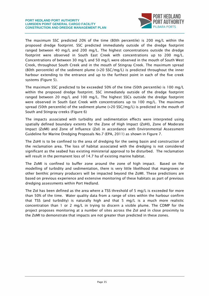
The maximum SSC predicted 20% of the time (80th percentile) is 200 mg/L within the
proposed dredge footprint. SSC predicted immediately outside of the dredge footprint
ranged between 40 mg/L and 200 mg/L. The highest concentrations outside the dredge
footprint were observed in South East Creek with concentrations up to 200 mg/L.
Concentrations of between 30 mg/L and 50 mg/L were observed in the mouth of South West
Creek, throughout South Creek and in the mouth of Stingray Creek. The maximum spread
(80th percentile) of the sediment plume (>20 SSC/mg/L) is predicted throughout the inner
harbour extending to the entrance and up to the furthest point in each of the five creek
systems (Figure 5).
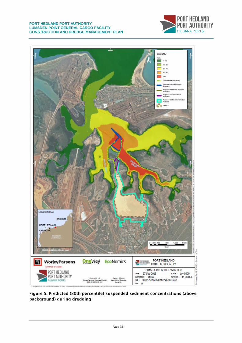
The maximum SSC predicted to be exceeded 50% of the time (50th percentile) is 100 mg/L
within the proposed dredge footprint. SSC immediately outside of the dredge footprint
ranged between 20 mg/L and 100 mg/L. The highest SSCs outside the dredge footprint
were observed in South East Creek with concentrations up to 100 mg/L. The maximum
spread (50th percentile) of the sediment plume (>20 SSC/mg/L) is predicted in the mouth of
South and Stingray creeks (Figure 6)
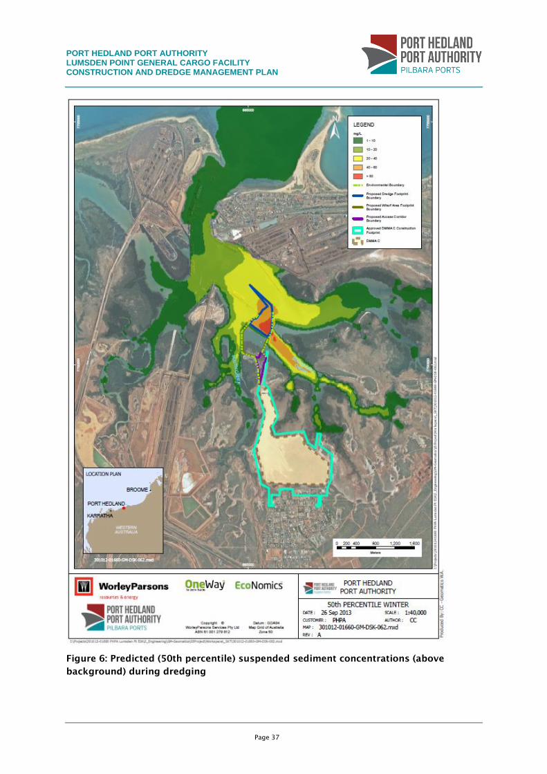
The impacts associated with turbidity and sedimentation effects were interpreted using
spatially defined boundary extents for the Zone of High Impact (ZoHI), Zone of Moderate
Impact (ZoMI) and Zone of Influence (ZoI) in accordance with Environmental Assessment
Guideline for Marine Dredging Proposals No.7 (EPA, 2011) as shown in Figure 7.
The ZoHI is to be confined to the area of dredging for the swing basin and construction of
the reclamation area. The loss of habitat associated with the dredging is not considered
significant as the seabed has existing ministerial approval to be disturbed. The reclamation
will result in the permanent loss of 14.7 ha of existing marine habitat.
The ZoMI is confined to buffer zone around the zone of high impact. Based on the
modelling of turbidity and sedimentation, there is very little likelihood that mangroves or
other benthic primary producers will be impacted beyond the ZoMI. These predictions are
based on previous experience and extensive monitoring of these habitats as part of previous
dredging assessments within Port Hedland.
The ZoI has been defined as the area where a TSS threshold of 5 mg/L is exceeded for more
than 50% of the time. Water quality data from a range of sites within the harbour confirm
that TSS (and turbidity) is naturally high and that 5 mg/L is a much more realistic
concentration than 1 or 2 mg/L in trying to discern a visible plume. The CDMP for the
project proposes monitoring at a number of sites across the ZoI and in close proximity to
the ZoMI to demonstrate that impacts are not greater than predicted in these zones.
PORT HEDLAND PORT AUTHORITY LUMSDEN POINT GENERAL CARGO FACILITY CONSTRUCTION AND DREDGE MANAGEMENT PLAN
Page 36
Figure 5: Predicted (80th percentile) suspended sediment concentrations (above
background) during dredging
PORT HEDLAND PORT AUTHORITY LUMSDEN POINT GENERAL CARGO FACILITY CONSTRUCTION AND DREDGE MANAGEMENT PLAN
Page 37
Figure 6: Predicted (50th percentile) suspended sediment concentrations (above
background) during dredging
PORT HEDLAND PORT AUTHORITY LUMSDEN POINT GENERAL CARGO FACILITY CONSTRUCTION AND DREDGE MANAGEMENT PLAN
Page 38
Figure 7: Predicted zones of impact and zones of influence
PORT HEDLAND PORT AUTHORITY LUMSDEN POINT GENERAL CARGO FACILITY CONSTRUCTION AND DREDGE MANAGEMENT PLAN
Page 39
Other potential impacts include the release of contaminants into the water column following
disturbance and the spillage of hydrocarbons during dredging and construction activities.
Assessment of sediment quality data from the proposed dredging location has confirmed
that contaminants are present in very low concentrations and do not exceed recommended
screening levels. The use of hydrocarbons will be primarily for powering of dredging vessels
and construction machinery in the form of diesel. Lower volumes of heavier based
hydrocarbons in the form of lubricant and hydraulic liquids will also be used. Given the
volumes to be used are relatively low, the potential risk of impact to the environment is
considered low.
Potential impacts to water quality from dewatering activities include altered physical
parameters in the discharge water. Trigger levels proposed for the discharge water from the
DMMAs have been based on the adopted Pilbara Water Quality ecological objectives to meet
a high level of ecological protection the South East Creek and South Creek.
Construction activities have the potential to cause changes in water quality via runoff from
exposed/cleared areas. Due to Port Hedland’s low rainfall, the potential impacts associated
with these activities on water quality are considered low. Management measures that will
mitigate this potential impact have been described in Section 6.1.2.
6.1.2 Management of water quality during dredging and
dewatering activities
Management
area
Water quality
Performance
objective
To minimise the generation and migration of turbid plumes during
dredging activities which may cause impacts to coral and mangrove
communities through sedimentation or increases in turbidity.
Key
performance
indicators
No long-term deterioration in water quality after the cessation of
dredging.
No detected injury/mortality to marine fauna as a result of
deterioration in water quality.
No significant hydrocarbon spills and all spills responded to in
accordance with the PHPA’s Marine Oil Pollution Management Plan.
Complaints investigated and responded to with two weeks of
complaint.
Management
actions
Installation of a satellite-based vessel monitoring system on the
dredge, allowing a track plot analysis to ensure maximum efficiency
of the dredging effort and that no dredging occurs outside the
required area.
Use of suitable dredging plant and equipment to minimise turbidity,
including well-maintained floating pipelines to be used to minimise
PORT HEDLAND PORT AUTHORITY LUMSDEN POINT GENERAL CARGO FACILITY CONSTRUCTION AND DREDGE MANAGEMENT PLAN
Page 40
Management
area
Water quality
leakage of turbid water during pumping of material to the DMMAs.
Maintaining calibration of the hydrographic survey systems onboard
the dredge.
Implementation of the Tiered Monitoring Framework following a
water quality trigger breach in accordance with the monitoring
program (Figure 9 and Figure 11).
Maximise the residence time in the reclamation area to reduce the
turbidity plume of the tailwater discharge. Suitable controls (e.g.
weir boxes) will be used at the discharge point to control the water
level and the rate of discharge.
Surface water runoff from construction site and corridors will be
contained where appropriate and discharge controlled such that
there are no significant, physical offsite impacts.
Regular inspection and maintenance of erosion and sediment control
structures, particularly following heavy or prolonged rainfall.
Monitoring Implementation of the Routine Water Quality Monitoring Program
(Section 7.2).
Implementation of the BPPH Monitoring and Routine Mangrove Health
Program (Section 7.3 and Section 7.4 respectively).
Dredge contractor to monitor the operation on a continual basis and
report any incidents that are likely to cause substantial changes to
water quality.
Responsibility The dredge contractor is responsible for monitoring the dredging,
disposal and reclamation operations and undertaking management
actions assigned to them.
The PHPA is responsible for the implementation of water quality and
sedimentation monitoring programs defined in Section 7.2 and
Section 7.4.
Reporting All reporting requirements are detailed in Section 8.
Corrective
action
Revision of dredging strategy, including potential relocation of the
dredge(s) and alterations to operational mode if plumes exceed
predicted ranges and are considered to affect key sensitive habitats.
Implementation of the Reactive Mangrove Health Monitoring Program
and Reactive Coral Health Investigation (sections 7.3 and 7.4).
Notification to the EPA, if water quality exceeds the predicted trigger
values, for consideration of the need for any corrective action.
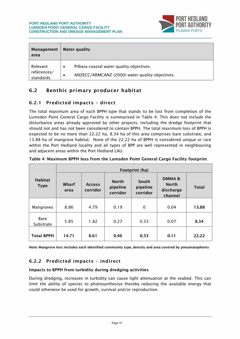
PORT HEDLAND PORT AUTHORITY LUMSDEN POINT GENERAL CARGO FACILITY CONSTRUCTION AND DREDGE MANAGEMENT PLAN
Page 41
Management
area
Water quality
Relevant
references/
standards
Pilbara coastal water quality objectives.
ANZECC/ARMCANZ (2000) water quality objectives.
6.2 Benthic primary producer habitat
6.2.1 Predicted impacts – direct
The total maximum area of each BPPH type that stands to be lost from completion of the
Lumsden Point General Cargo Facility is summarised in Table 4. This does not include the
disturbance areas already approved by other projects, including the dredge footprint that
should not and has not been considered to contain BPPH. The total maximum loss of BPPH is
expected to be no more than 22.22 ha, 8.34 ha of this area comprises bare substrate, and
13.88 ha of mangrove habitat. None of the 22.22 ha of BPPH is considered unique or rare
within the Port Hedland locality and all types of BPP are well represented in neighbouring
and adjacent areas within the Port Hedland LAU.
Table 4: Maximum BPPH loss from the Lumsden Point General Cargo Facility footprint
Habitat
Type
Footprint (ha)
Wharf
area
Access
corridor
North
pipeline
corridor
South
pipeline
corridor
DMMA B-
North
discharge
channel
Total
Mangroves 8.86 4.79 0.19 0 0.04 13.88
Bare
Substrate 5.85 1.82 0.27 0.33 0.07 8.34
Total BPPH 14.71 6.61 0.46 0.33 0.11 22.22
Note: Mangrove loss includes each identified community type, density and area covered by pneumatophores
6.2.2 Predicted impacts – indirect
Impacts to BPPH from turbidity during dredging activities
During dredging, increases in turbidity can cause light attenuation at the seabed. This can
limit the ability of species to photosynthesise thereby reducing the available energy that
could otherwise be used for growth, survival and/or reproduction.
PORT HEDLAND PORT AUTHORITY LUMSDEN POINT GENERAL CARGO FACILITY CONSTRUCTION AND DREDGE MANAGEMENT PLAN
Page 42
Sediment plume modelling undertaken predicted that SSC concentrations will increase to
200 mg/L. Generally SSC concentrations will range between 20 mg/L to 100 mg/L adjacent
to dredging activities.
To identify the extent of impacts associated with increases in turbidity, light irradiance at
the seabed was calculated for sites known to be dominated by BPP during previous dredging
campaigns. It was found that light irradiance levels predicted for this project will be similar
to those levels experienced during previous dredging projects. Given that no impacts were
observed following any of the previous dredging campaigns, it is deemed highly unlikely
that BPPH will be affected by temporary elevated SSC levels associated with the proposed
dredging program.
Impacts to BPPH from sedimentation caused by dredging
As turbid plumes migrate from the point of disturbance, sedimentation can occur in areas
that experience reduced current flow as sediments fall out of suspension due to gravity.
Increases in sedimentation reduce the amount of light captured by BPPs at the seabed and
can physically smother organisms.
Sediment plume modelling undertaken to predict sedimentation rates during dredging
activities indicates sedimentation thickness levels between 2 mm and 200 mm (Figure 8).
Mangrove communities adjacent to the Project footprint are likely to experience an increase
of up to 10 mm. Other BPPs predicted to be exposed to sediment levels up to 20 mm
include small coral communities located in South East Creek and the entrance to Stingray
Creek and patches of turfing algae and macroalgae found throughout the inner harbour.
Predicted sedimentation levels identified during previous dredging projects and BPPH data
collected after the completion of post dredging surveys showed the BPPH predicted to be
influenced by the Project will not be impacted. Sedimentation levels were found to be below
sedimentation levels previously predicted, which had no impact on BPPH within the Port
Hedland inner harbour.
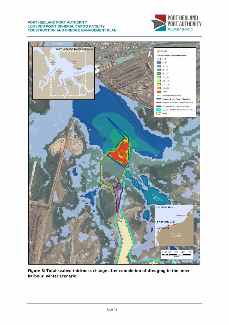
PORT HEDLAND PORT AUTHORITY LUMSDEN POINT GENERAL CARGO FACILITY CONSTRUCTION AND DREDGE MANAGEMENT PLAN
Page 43
Figure 8: Total seabed thickness change after completion of dredging in the inner
harbour: winter scenario.
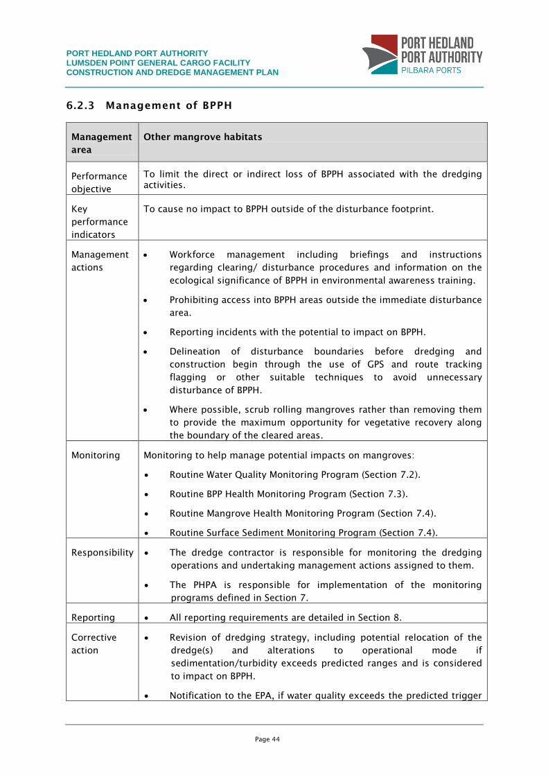
PORT HEDLAND PORT AUTHORITY LUMSDEN POINT GENERAL CARGO FACILITY CONSTRUCTION AND DREDGE MANAGEMENT PLAN
Page 44
6.2.3 Management of BPPH
Management
area
Other mangrove habitats
Performance
objective
To limit the direct or indirect loss of BPPH associated with the dredging
activities.
Key
performance
indicators
To cause no impact to BPPH outside of the disturbance footprint.
Management
actions
Workforce management including briefings and instructions
regarding clearing/ disturbance procedures and information on the
ecological significance of BPPH in environmental awareness training.
Prohibiting access into BPPH areas outside the immediate disturbance
area.
Reporting incidents with the potential to impact on BPPH.
Delineation of disturbance boundaries before dredging and
construction begin through the use of GPS and route tracking
flagging or other suitable techniques to avoid unnecessary
disturbance of BPPH.
Where possible, scrub rolling mangroves rather than removing them
to provide the maximum opportunity for vegetative recovery along
the boundary of the cleared areas.
Monitoring Monitoring to help manage potential impacts on mangroves:
Routine Water Quality Monitoring Program (Section 7.2).
Routine BPP Health Monitoring Program (Section 7.3).
Routine Mangrove Health Monitoring Program (Section 7.4).
Routine Surface Sediment Monitoring Program (Section 7.4).
Responsibility The dredge contractor is responsible for monitoring the dredging
operations and undertaking management actions assigned to them.
The PHPA is responsible for implementation of the monitoring
programs defined in Section 7.
Reporting All reporting requirements are detailed in Section 8.
Corrective
action
Revision of dredging strategy, including potential relocation of the
dredge(s) and alterations to operational mode if
sedimentation/turbidity exceeds predicted ranges and is considered
to impact on BPPH.
Notification to the EPA, if water quality exceeds the predicted trigger
PORT HEDLAND PORT AUTHORITY LUMSDEN POINT GENERAL CARGO FACILITY CONSTRUCTION AND DREDGE MANAGEMENT PLAN
Page 45
Management
area
Other mangrove habitats
values, for consideration of the need for any corrective action.
Implementation of Reactive Mangrove and Coral Health Monitoring
Program.
Relevant
references/
standards
EAG 3 (EPA 2009a).
Guidance for the assessment of environmental factors (in accordance
with the Environmental Protection Act 1986).
EAG 1(EPA 2001).
6.3 Marine fauna
6.3.1 Predicted impacts
The presence of vessels during construction may increase the likelihood of a direct collision
with pollufauna, particularly marine turtles. Turtles are vulnerable to boat strike while
surfacing to breathe or as a startle response to dredging noise or visual cues. They are also
vulnerable to collision with boat propellers in shallow water, where there is little clearance
between the keel and the benthos.
Light sources during dredging activities will include work lights, safety lights, navigational
lights and vessel lighting. Turtle hatchlings use lighting cues when they hatch and move
down the beach to the water’s edge. Some forms of artificial lighting have been found to
disorientate hatchlings and reduce their ability to access the sea following hatching. The
impacts associated with disorientation of turtle hatchlings are unlikely given the large
distance between the dredge footprint and marine turtle nesting beaches. Altered
underwater light conditions in inshore waters may also change the levels of predation on
turtle hatchlings, by attracting fish and other predators.
Dredging and piling activities that have the potential to affect marine fauna via underwater
noise (e.g. cetaceans, turtles and dugongs) may range from non-injurious effects (e.g.
acoustic annoyance, mild tactile detection or physical discomfort) to varying levels of injury
(i.e. non-lethal and lethal injuries). The number of marine fauna that could potentially be
affected by piling activities will be minimal given there is limited known habitat, feeding and
or breeding areas within the inner harbour. It is unlikely that underwater noise associated
with dredging activities will cause additional underwater noise impacts during dredging and
operation because the shipping and vessel noise will be at a scale of magnitude less than
current shipping activities within the existing port areas.
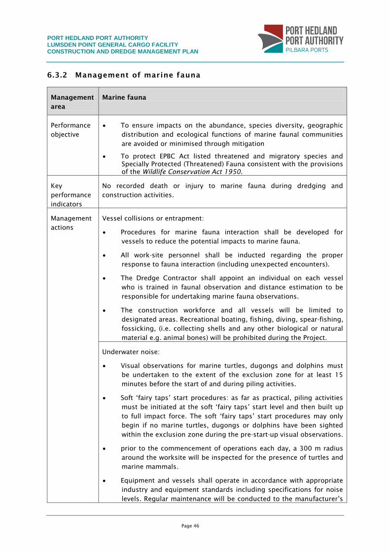
PORT HEDLAND PORT AUTHORITY LUMSDEN POINT GENERAL CARGO FACILITY CONSTRUCTION AND DREDGE MANAGEMENT PLAN
Page 46
6.3.2 Management of marine fauna
Management
area
Marine fauna
Performance
objective
To ensure impacts on the abundance, species diversity, geographic
distribution and ecological functions of marine faunal communities
are avoided or minimised through mitigation
To protect EPBC Act listed threatened and migratory species and
Specially Protected (Threatened) Fauna consistent with the provisions
of the Wildlife Conservation Act 1950.
Key
performance
indicators
No recorded death or injury to marine fauna during dredging and
construction activities.
Management
actions
Vessel collisions or entrapment:
Procedures for marine fauna interaction shall be developed for
vessels to reduce the potential impacts to marine fauna.
All work-site personnel shall be inducted regarding the proper
response to fauna interaction (including unexpected encounters).
The Dredge Contractor shall appoint an individual on each vessel
who is trained in faunal observation and distance estimation to be
responsible for undertaking marine fauna observations.
The construction workforce and all vessels will be limited to
designated areas. Recreational boating, fishing, diving, spear-fishing,
fossicking, (i.e. collecting shells and any other biological or natural
material e.g. animal bones) will be prohibited during the Project.
Underwater noise:
Visual observations for marine turtles, dugongs and dolphins must
be undertaken to the extent of the exclusion zone for at least 15
minutes before the start of and during piling activities.
Soft ‘fairy taps’ start procedures: as far as practical, piling activities
must be initiated at the soft ‘fairy taps’ start level and then built up
to full impact force. The soft ‘fairy taps’ start procedures may only
begin if no marine turtles, dugongs or dolphins have been sighted
within the exclusion zone during the pre-start-up visual observations.
prior to the commencement of operations each day, a 300 m radius
around the worksite will be inspected for the presence of turtles and
marine mammals.
Equipment and vessels shall operate in accordance with appropriate
industry and equipment standards including specifications for noise
levels. Regular maintenance will be conducted to the manufacturer’s
PORT HEDLAND PORT AUTHORITY LUMSDEN POINT GENERAL CARGO FACILITY CONSTRUCTION AND DREDGE MANAGEMENT PLAN
Page 47
Management
area
Marine fauna
specifications. Equipment covers, mufflers and other noise
suppression equipment shall also be maintained and in good
working order at all times.
Dredging and piling activities will be ceased if a significant marine
mammal or reptile is sighted within the ’monitoring zone’ of 300 m
radius around the dredge or piling barge.
The use of thrusters and excessively noisy equipment will be avoided
wherever practicable and engines, thrusters and auxiliary plant will
not be left in ‘stand by’ or ‘running’ mode unnecessarily.
Artificial lighting:
Where practicable, vessel loading and unloading in nearshore areas
shall be conducted during daylight hours. Where this is not
practicable, artificial lighting shall be reduced to the minimum
required for safe operations.
Outside artificial lighting on vessels will be kept to a minimum (i.e.
navigational lights and where safety dictates necessary deck
lighting). Lighting should be switched off when not in use and
automatic timers/sensors installed where possible.
Only necessary artificial lights shall be used. ‘Unnecessary lighting’
includes lighting in unused areas, decorative lighting or lighting that
is brighter than needed.
Monitoring Marine fauna observations:
Before starting dredging activities, the PHPA must check, using
binoculars from a high observation platform on the vessel, for
marine turtles within the monitoring zone.
If any turtles, cetaceans or dugongs are sighted in the monitoring
zone, dredging activities must not start in the monitoring zone until
15 minutes after the last marine mammal/turtle is observed to leave
the monitoring zone or the dredge is to move to another area of the
dredge site to maintain a minimum distance of 300 m between the
vessel and any marine mammal/turtle identified during observations.
Monitor light spill during dredging and construction activities.
Responsibility The Dredge Contractor is responsible for implementation of
management actions.
The Dredge Contractor is responsible for maintaining all equipment
to ensure underwater noise levels are kept to a minimum. All
incidents associated with elevated noise that could affect marine
fauna must be reported to the PHPA Environment Manager.
PORT HEDLAND PORT AUTHORITY LUMSDEN POINT GENERAL CARGO FACILITY CONSTRUCTION AND DREDGE MANAGEMENT PLAN
Page 48
Management
area
Marine fauna
Reporting All reporting requirements are detailed in Section 8.
Corrective
action
Revision of dredging strategy, including potential relocation of the
dredge(s) and alterations to operational mode.
Notification to the EPA, if water quality exceeds the predicted trigger
values, for consideration of need for any corrective action.
Relevant
references/
standards
The Australian National Guidelines for Whale and Dolphin Watching
(Department of Environment and Heritage 2006).
6.4 Introduced marine species
6.4.1 Predicted impacts
The increase in the number of vessel movements associated with dredging and construction
could represent an increased threat of exposure to introduced marine species (IMS). The
introduction of non-indigenous species could lead to irreversible detrimental impacts to the
composition and function of the natural ecosystem through changes in competition,
predation, or habitat modification. The Project provides opportunities for IMS to establish in
two ways: on structures installed as part of the new facility infrastructure, and on Project
vessels working in the harbour during the 20-week dredging period. The former will offer
the highest chance of colonisation when first immersed, with likelihood decreasing with
time as exposed surfaces are colonised by established native marine flora and fauna
communities. The risk of Project vessels being colonised may increase during the Project as
antifouling systems age and become damaged during operation.
Of the seven pest species designated as the basis for management of domestic ballast water
movements, none is currently listed as present in Port Hedland, which means that water
taken up as ballast or entrained in Port Hedland is deemed low risk for discharge in other
Australian ports and coastal waters. The proposed dredge vessel that will be used during
dredging has not yet been identified. Quarantine measures will have already been
undertaken before dredging takes place.
6.4.2 Management of introduced marine species
Management
area
Introduced marine species
Performance
objective
Minimise the risk of introduction of unwanted marine organisms
consistent with the Australian Quarantine Inspection Services (AQIS)
guidelines for ballast water management (AQIS 2008) and ANZECC Code of
Practice for Antifouling and In-water Hull Cleaning and Maintenance
(ANZECC 1997).
PORT HEDLAND PORT AUTHORITY LUMSDEN POINT GENERAL CARGO FACILITY CONSTRUCTION AND DREDGE MANAGEMENT PLAN
Page 49
Management
area
Introduced marine species
Key
performance
indicators
No introduction of an invasive IMS during dredging and construction
activities.
Management
actions
Before mobilisation and during dredging:
Comply with the Department of Agriculture requirements, state and
federal legislation and particular provisions presented in this referral
for dredges.
Any vessels coming to Port Hedland for the Project from other
Australian locations that carry ballast or entrained water are required
to have the risk status of that water assessed, considering the
location of uptake and time of year, and to manage the water in
accordance with the requirements of the National System for the
Prevention and Management of Marine Pest Incursions, if it is
deemed to be high risk.
Any vessels coming to Port Hedland for the Project from overseas or
domestically should be subject to a biofouling risk assessment
following guidance within the Western Australian marine pest
management guidelines and the National Biofouling Management
Guidance for Non-Trading Vessels document. Vessels assessed as
posing a risk should be inspected to ensure they are free of
biofouling and preferably dry-docked for cleaning and repair/renewal
of the antifouling system immediately before departure for Australia.
All areas where mud and sediments can collect, including anchor and
chain lockers and hoppers, should be inspected and cleaned before
a vessel’s departure for Port Hedland. Anchor chains, cables, and
other gear that has been deployed overboard should also be
inspected and cleaned of any attached or entangled marine growth.
These procedures should be repeated before departure from Port
Hedland to prevent translocation of species away from this region.
Monitoring Monitoring and surveillance of the dredge vessel and barges in
accordance with Department of Agriculture and PHPA quarantine
requirements.
Responsibility The dredging contractor is responsible for complying with existing
PHPA quarantine requirements and management.
Reporting All reporting requirements are detailed in Section 8.
Corrective
action
Implementation of contingency measures as required by PHPA
quarantine requirements.
Notification to the EPA and DoF if a marine pest species is
PORT HEDLAND PORT AUTHORITY LUMSDEN POINT GENERAL CARGO FACILITY CONSTRUCTION AND DREDGE MANAGEMENT PLAN
Page 50
Management
area
Introduced marine species
introduced.
Relevant
references/
standards
Australian Quarantine Act 1908
Australian Ballast Water Management Requirements (AQIS 2008)
National Biofouling Management Guidance for Commercial Vessels
(DAFF 2009a)
National Biofouling Management Guidance for Non-trading Vessels
(DAFF 2009b)
ANZECC Code of Practice for Antifouling and In-water Hull Cleaning
and Maintenance (ANZECC 1997)
Environmental Protection Act 1986 (WA)
Fisheries Resources Management Act 1994 (WA)
Western Australian marine pest management guidelines (DoF 2012)
The PHPA’s Introduced Marine Pest Guidelines.
6.5 Terrestrial flora and fauna
6.5.1 Predicted impacts
The mangrove and intertidal area in the Project footprint is tide dominated and is in
constant transition between marine and terrestrial habitats. It has high habitat value for
fauna species and its open ground provides habitat for foraging marine/aquatic migratory
waders (WorleyParsons 2012a). According to the EPBC Act Protected Matters report
generated to identify potential matters of significance that may occur within 10 km of the
Project footprint, two endangered and two vulnerable species, 47 migratory-listed bird
species and 38 fauna species protected under EPBC Act can potentially occur in the study
area. Additionally, five conservation significant species were recorded in the survey: the
eastern great egret, the common sandpiper, the whimbrel, the lesser crested tern and the
rainbow bee-eater (WorleyParsons 2012a).
No significant impacts on the migratory bird species recorded are anticipated, given they
can move away from disturbance. Dredging and construction activities are unlikely to affect
critical feeding or breeding habitat and similar habitat occurs across Port Hedland and the
broader Pilbara region.
Potential hydrocarbon spills from the dredging vessels may affect the local fauna as direct
contact with diesel can affect marine birds by ingestion as well as cause hypothermia from
matted feathers. Construction activities may also result in minor hydrocarbon spillages from
plant and equipment, which could affect water quality and disturb local fauna. These are,
however, unlikely to occur.
PORT HEDLAND PORT AUTHORITY LUMSDEN POINT GENERAL CARGO FACILITY CONSTRUCTION AND DREDGE MANAGEMENT PLAN
Page 51
Light emissions from the dredging operations and construction activities have the potential
to attract seabirds and extend their foraging time through the night. However, these
activities are not expected to increase light emissions significantly over that which the port
already experiences. Nevertheless, management measures should be implemented to reduce
any excess light.
The vegetation communities and fauna habitats recorded are not considered of conservation
significance and are isolated and segregated from the local area due to existing
infrastructure and disturbances
6.5.2 Management of terrestrial flora and fauna
Management
area
Terrestrial flora and fauna
Performance
objective
To ensure impacts on the abundance, species diversity, geographic
distribution and ecological functions of terrestrial fauna are avoided or
minimised through mitigation.
To protect EPBC Act listed threatened and migratory species and Specially
Protected (Threatened) Fauna consistent with the provisions of the Wildlife
Conservation Act 1950.
Key
performance
indicators
No recorded death or injury to terrestrial fauna during constructions
activities.
No long-term deterioration in the terrestrial habitat after cessation of the
construction activities.
Management
actions
Before mobilisation and during construction operations:
workforce management including briefings and instructions
regarding clearing/disturbance procedures in environmental
awareness training;
construction workforce and vehicle movement will be limited to
designated areas;
speed restrictions, driver awareness and removal of road kill shall be
enforced to minimise potential impacts arising from vehicular
movement;
noise emissions and use of lighting during construction shall be
minimised where practicable; and
design night-lighting so as to not shine directly onto mangrove
habitats (low-pressure sodium vapour lamps are recommended).
During dredging operations:
artificial lighting shall be reduced to the minimum required for safe
operations; and
PORT HEDLAND PORT AUTHORITY LUMSDEN POINT GENERAL CARGO FACILITY CONSTRUCTION AND DREDGE MANAGEMENT PLAN
Page 52
Management
area
Terrestrial flora and fauna
outside artificial lighting on vessels will be kept to a minimum and
lighting should be switched off when not in use and automatic
timers/sensors installed where possible.
Monitoring Shore-based contractor to monitor the operation on a continual basis
and report any incidents with local fauna.
Responsibility Both the dredge and shore-based contractors are responsible for
complying will the relevant management strategies during
construction in accordance with their contractual responsibilities.
The PHPA is responsible for reporting as detailed in Section 7.
Reporting All reporting requirements are detailed in Section 8.
Corrective
action
Revision of general earthworks operational mode if any activity leads
to death or injury to terrestrial fauna.
Relevant
references/
standards
Wildlife Conservation Act 1950 (WC Act).
Environmental Protection Act 1986 (EP Act).
Environment Protection and Biodiversity Conservation Act 1999 (EPBC
Act), Schedule 3
Environmental Protection (Clearing of Native Vegetation) Regulations
2004
6.6 Air quality
6.6.1 Predicted impacts
The Project requires an estimated volume of two million cubic metres of dredge material to
be disposed of onshore, and has the potential to generate significant volumes of fine
material. Given the fine material will be placed into existing or approved DMMAs, any dust
impacts associated with these areas will be managed under each of their respective
Ministerial Statement.
The wharf area will reclaim approximately 25 ha of land using either dredge material from
the dredge area or, if this material is found to be unsuitable for reclamation material, an
alternative source will be identified. The placement of material in this area has the potential
to generate dust emissions which could potentially cause changes to ambient air quality. In
addition, construction activities – principally land clearing, the use of earth-moving
machinery for bund wall construction and vehicle and equipment traffic on unsealed roads
and laydown areas – also has the potential to generate dust.
While modelling of potential levels of dust generated from the proposed development has
not been undertaken for this Project, dust modelling was undertaken for the development of
BHP Billiton’s DMMA H for the Nelson Point dredging program. This investigation found that
PORT HEDLAND PORT AUTHORITY LUMSDEN POINT GENERAL CARGO FACILITY CONSTRUCTION AND DREDGE MANAGEMENT PLAN
Page 53
uncontrolled dust generated from DMMA H would not change the cumulative dust levels
predicted at the Port Hedland Hospital monitoring location (BHPBIO 2009). DMMA H covers
an area of 204 ha, while the proposed wharf area for reclamation covers an area of 25 ha.
Hence the impact of dust will be minimal. Sufficient management actions have been
incorporated below in Section 6.6.2.
Other gaseous emissions such as NOx and SOx, particulates (PM10) and volatile organic
compounds (VOCs) are expected to be minimal during the Project’s construction and
operation and only associated with fuel combustion from the operation of construction
machinery and the exhaust emissions of marine vessels. Emissions of VOCs due to
combustion and evaporation during welding works, as well as evaporation from paints and
solvents used onsite, are likely to be in small quantities and localised in effect.
6.6.2 Management of air quality
Management
area
Air quality
Performance
objective
To ensure best practice for managing air emission levels during onshore
construction activities.
Key
performance
indicators
Non-exceedence of relevant air quality emission standards and guidelines.
Management
actions
Before mobilisation and during construction:
staff induction program to ensure all employees are made aware of
the need to minimise dust generation;
regular watering of unsealed roads, exposed surfaces, active
construction areas and stockpiles;
minimisation of traffic on unsealed roads;
re-vegetation and establishment of groundcover;
general housekeeping practices to ensure that there is no
accumulation of waste materials within the construction site that may
generate dust;
restriction of vehicle movements and vehicle speeds to reduce
gaseous and dust emissions;
regular monitoring and maintenance of plant and equipment so that
it remains in good working condition and gaseous emissions are
kept to a minimum; and
all equipment will be switched off when not in use.
Monitoring All reporting requirements are detailed in Section 8.
Responsibility All reporting requirements are detailed in Section 8.
PORT HEDLAND PORT AUTHORITY LUMSDEN POINT GENERAL CARGO FACILITY CONSTRUCTION AND DREDGE MANAGEMENT PLAN
Page 54
Management
area
Air quality
Reporting Assessment and amendment of management practices to remove risk
of reoccurrence
Corrective
action
Environmental Protection Act 1986 (EP Act).
Relevant
references/
standards
To ensure best practice for managing air emission levels during onshore
construction activities.
6.7 Noise and vibration
6.7.1 Predicted impacts
The key sources of potential offsite noise emissions are associated with piling activities
during construction of the marine structures and operation of the cutter suction dredge.
Construction and dredging noise will be managed in accordance with existing procedures
that have been applied in other recent expansion projects in the Port Hedland. This will
include developing a Project-specific Construction noise management plan (CNMP) in
accordance with the Environmental Protection (Noise) Regulations 1997 with approval of the
CNMP by the Town of Port Hedland. Offsite noise emissions from the proposal are not
expected to be significant.
6.7.2 Management of noise and vibration
Management
area
Noise and vibration
Performance
objective
To ensure best practice for managing noise and vibration levels during
dredging and onshore construction activities.
Key
performance
indicators
Received noise levels at receptor sites not to exceed thresholds.
Management
actions
The construction work and dredging activity will be carried out in
accordance with the Environmental Protection (Noise) Regulations
1997 and the control of noise practices set out in Section 6 of
Australian Standard 2436-1981 Guide to noise control on
construction, maintenance and demolition sites.
The equipment used for the construction will be the quietest
reasonably available.
Regular monitoring and maintenance of plant and equipment will be
undertaken so that it remains in good working condition and noise

PORT HEDLAND PORT AUTHORITY LUMSDEN POINT GENERAL CARGO FACILITY CONSTRUCTION AND DREDGE MANAGEMENT PLAN
Page 55
Management
area
Noise and vibration
emissions are kept to a minimum.
All equipment will be switched off when not in use.
All employees and contractors will be made aware of the need to
minimise noise.
Monitoring Monitoring will be detailed in the noise management plan developed
before construction and dredging activities begin.
Responsibility Shore-based contractors are responsible for complying will the
relevant management strategies during construction in accordance
with their contractual responsibilities.
The PHPA is responsible for reporting as detailed in Section 8.
Reporting All reporting requirements are detailed in Section 8.
Corrective
action
Assessment and amendment of management practices to remove risk
of reoccurrence.
Relevant
references/
standards
Environmental Protection (Noise) Regulations 1997.
Guidance statement 8: Environmental noise (draft) (EPA 2007).
Australian Standard 2436-1981 Guide to noise control on
construction, maintenance and demolition sites.
6.8 Waste management
6.8.1 Predicted impacts
Solid and liquid wastes generated during dredging and construction have the potential to
negatively impact on the surrounding environment if appropriate waste management
measures are not put in place. Solid and liquid wastes that may be generated by the Project
include:
packaging material (plastic wrapping, pallets etc.);
concrete;
scrap metal;
waste oil, hydrocarbons and hazardous materials (see Section 6.9);
recyclable materials (paper, cardboard, aluminium);
general food packaging and scraps; and
domestic sewage.
Although no discharge of waste to the marine environment within the 12 nm limit is to take
place, the potential exists for accidental discharges of small quantities of solid or liquid
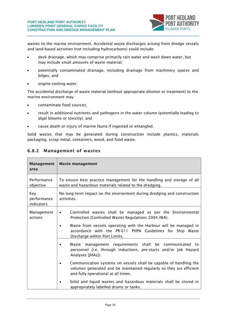
PORT HEDLAND PORT AUTHORITY LUMSDEN POINT GENERAL CARGO FACILITY CONSTRUCTION AND DREDGE MANAGEMENT PLAN
Page 56
wastes to the marine environment. Accidental waste discharges arising from dredge vessels
and land-based activities (not including hydrocarbons) could include:
deck drainage, which may comprise primarily rain water and wash down water, but
may include small amounts of waste material;
potentially contaminated drainage, including drainage from machinery spaces and
bilges; and
engine cooling water.
The accidental discharge of waste material (without appropriate dilution or treatment) to the
marine environment may:
contaminate food sources;
result in additional nutrients and pathogens in the water column (potentially leading to
algal blooms or toxicity); and
cause death or injury of marine fauna if ingested or entangled.
Solid wastes that may be generated during construction include plastics, materials
packaging, scrap metal, containers, wood, and food waste.
6.8.2 Management of wastes
Management
area
Waste management
Performance
objective
To ensure best practice management for the handling and storage of all
waste and hazardous materials related to the dredging.
Key
performance
indicators
No long-term impact on the environment during dredging and construction
activities.
Management
actions
Controlled wastes shall be managed as per the Environmental
Protection (Controlled Waste) Regulations 2004 (WA).
Waste from vessels operating with the Harbour will be managed in
accordance with the PR-E11 PHPA Guidelines for Ship Waste
Discharge within Port Limits.
Waste management requirements shall be communicated to
personnel (i.e. through inductions, pre-starts and/or Job Hazard
Analyses [JHAs]).
Communication systems on vessels shall be capable of handling the
volumes generated and be maintained regularly so they are efficient
and fully operational at all times.
Solid and liquid wastes and hazardous materials shall be stored in
appropriately labelled drums or tanks.
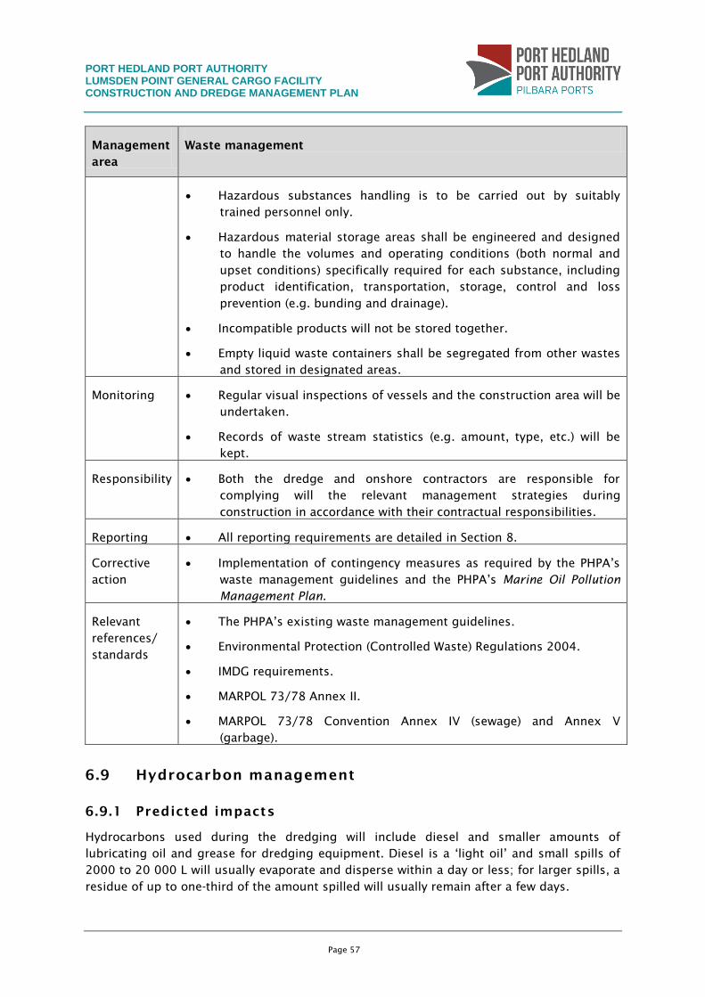
PORT HEDLAND PORT AUTHORITY LUMSDEN POINT GENERAL CARGO FACILITY CONSTRUCTION AND DREDGE MANAGEMENT PLAN
Page 57
Management
area
Waste management
Hazardous substances handling is to be carried out by suitably
trained personnel only.
Hazardous material storage areas shall be engineered and designed
to handle the volumes and operating conditions (both normal and
upset conditions) specifically required for each substance, including
product identification, transportation, storage, control and loss
prevention (e.g. bunding and drainage).
Incompatible products will not be stored together.
Empty liquid waste containers shall be segregated from other wastes
and stored in designated areas.
Monitoring Regular visual inspections of vessels and the construction area will be
undertaken.
Records of waste stream statistics (e.g. amount, type, etc.) will be
kept.
Responsibility Both the dredge and onshore contractors are responsible for
complying will the relevant management strategies during
construction in accordance with their contractual responsibilities.
Reporting All reporting requirements are detailed in Section 8.
Corrective
action
Implementation of contingency measures as required by the PHPA’s
waste management guidelines and the PHPA’s Marine Oil Pollution
Management Plan.
Relevant
references/
standards
The PHPA’s existing waste management guidelines.
Environmental Protection (Controlled Waste) Regulations 2004.
IMDG requirements.
MARPOL 73/78 Annex II.
MARPOL 73/78 Convention Annex IV (sewage) and Annex V
(garbage).
6.9 Hydrocarbon management
6.9.1 Predicted impacts
Hydrocarbons used during the dredging will include diesel and smaller amounts of
lubricating oil and grease for dredging equipment. Diesel is a ‘light oil’ and small spills of
2000 to 20 000 L will usually evaporate and disperse within a day or less; for larger spills, a
residue of up to one-third of the amount spilled will usually remain after a few days.
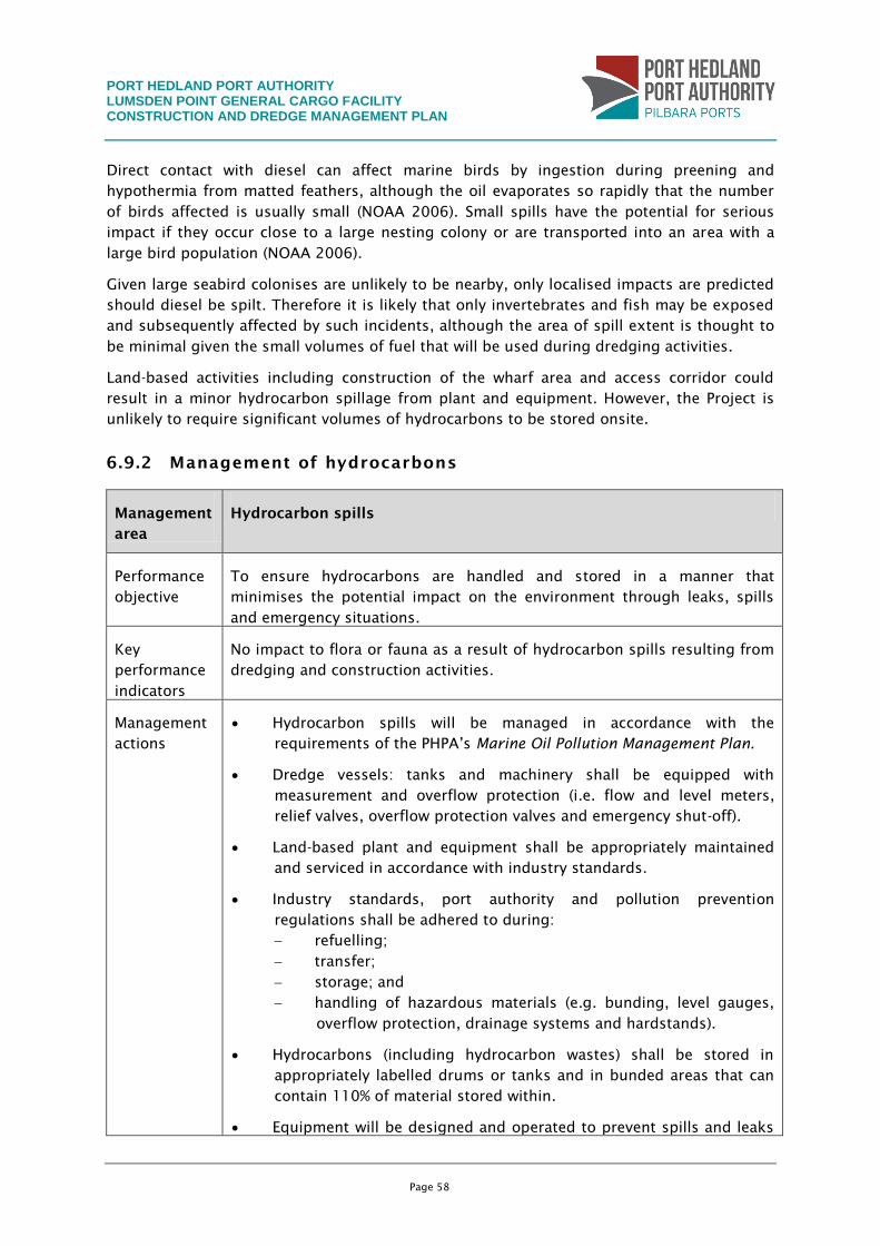
PORT HEDLAND PORT AUTHORITY LUMSDEN POINT GENERAL CARGO FACILITY CONSTRUCTION AND DREDGE MANAGEMENT PLAN
Page 58
Direct contact with diesel can affect marine birds by ingestion during preening and
hypothermia from matted feathers, although the oil evaporates so rapidly that the number
of birds affected is usually small (NOAA 2006). Small spills have the potential for serious
impact if they occur close to a large nesting colony or are transported into an area with a
large bird population (NOAA 2006).
Given large seabird colonises are unlikely to be nearby, only localised impacts are predicted
should diesel be spilt. Therefore it is likely that only invertebrates and fish may be exposed
and subsequently affected by such incidents, although the area of spill extent is thought to
be minimal given the small volumes of fuel that will be used during dredging activities.
Land-based activities including construction of the wharf area and access corridor could
result in a minor hydrocarbon spillage from plant and equipment. However, the Project is
unlikely to require significant volumes of hydrocarbons to be stored onsite.
6.9.2 Management of hydrocarbons
Management
area
Hydrocarbon spills
Performance
objective
To ensure hydrocarbons are handled and stored in a manner that
minimises the potential impact on the environment through leaks, spills
and emergency situations.
Key
performance
indicators
No impact to flora or fauna as a result of hydrocarbon spills resulting from
dredging and construction activities.
Management
actions
Hydrocarbon spills will be managed in accordance with the
requirements of the PHPA’s Marine Oil Pollution Management Plan.
Dredge vessels: tanks and machinery shall be equipped with
measurement and overflow protection (i.e. flow and level meters,
relief valves, overflow protection valves and emergency shut-off).
Land-based plant and equipment shall be appropriately maintained
and serviced in accordance with industry standards.
Industry standards, port authority and pollution prevention
regulations shall be adhered to during:
refuelling;
transfer;
storage; and
handling of hazardous materials (e.g. bunding, level gauges,
overflow protection, drainage systems and hardstands).
Hydrocarbons (including hydrocarbon wastes) shall be stored in
appropriately labelled drums or tanks and in bunded areas that can
contain 110% of material stored within.
Equipment will be designed and operated to prevent spills and leaks
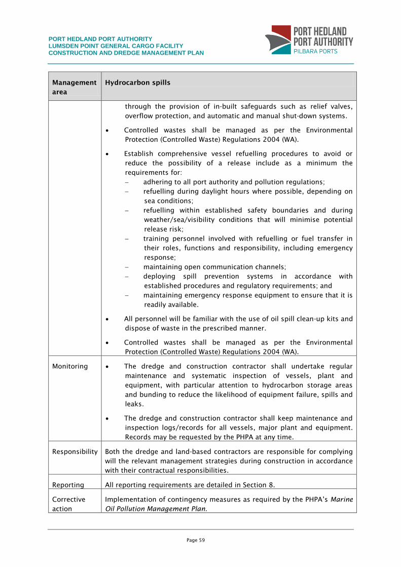
PORT HEDLAND PORT AUTHORITY LUMSDEN POINT GENERAL CARGO FACILITY CONSTRUCTION AND DREDGE MANAGEMENT PLAN
Page 59
Management
area
Hydrocarbon spills
through the provision of in-built safeguards such as relief valves,
overflow protection, and automatic and manual shut-down systems.
Controlled wastes shall be managed as per the Environmental
Protection (Controlled Waste) Regulations 2004 (WA).
Establish comprehensive vessel refuelling procedures to avoid or
reduce the possibility of a release include as a minimum the
requirements for:
adhering to all port authority and pollution regulations;
refuelling during daylight hours where possible, depending on
sea conditions;
refuelling within established safety boundaries and during
weather/sea/visibility conditions that will minimise potential
release risk;
training personnel involved with refuelling or fuel transfer in
their roles, functions and responsibility, including emergency
response;
maintaining open communication channels;
deploying spill prevention systems in accordance with
established procedures and regulatory requirements; and
maintaining emergency response equipment to ensure that it is
readily available.
All personnel will be familiar with the use of oil spill clean-up kits and
dispose of waste in the prescribed manner.
Controlled wastes shall be managed as per the Environmental
Protection (Controlled Waste) Regulations 2004 (WA).
Monitoring The dredge and construction contractor shall undertake regular
maintenance and systematic inspection of vessels, plant and
equipment, with particular attention to hydrocarbon storage areas
and bunding to reduce the likelihood of equipment failure, spills and
leaks.
The dredge and construction contractor shall keep maintenance and
inspection logs/records for all vessels, major plant and equipment.
Records may be requested by the PHPA at any time.
Responsibility Both the dredge and land-based contractors are responsible for complying
will the relevant management strategies during construction in accordance
with their contractual responsibilities.
Reporting All reporting requirements are detailed in Section 8.
Corrective
action
Implementation of contingency measures as required by the PHPA’s Marine
Oil Pollution Management Plan.
PORT HEDLAND PORT AUTHORITY LUMSDEN POINT GENERAL CARGO FACILITY CONSTRUCTION AND DREDGE MANAGEMENT PLAN
Page 60
Management
area
Hydrocarbon spills
Relevant
references/
standards
The PHPA’s Marine Oil Pollution Management Plan.
Environmental Protection (Controlled Waste) Regulations 2004 (WA).
PORT HEDLAND PORT AUTHORITY LUMSDEN POINT GENERAL CARGO FACILITY CONSTRUCTION AND DREDGE MANAGEMENT PLAN
Page 61
7. MONITORING PROGRAMS AND INSPECTIONS
Environmental attributes most susceptible to dredging and construction activities associated
with the Project include:
water quality;
BPP health; and
mangrove health.
In addition to the management actions to be put in place during dredging and construction,
environmental monitoring of the marine environment will also be undertaken to verify the
predicted impacts and to ensure they do not exceed their predicted magnitude.
The following monitoring is proposed for the Project:
physical water quality monitoring using telemetry-based water quality loggers and
collection of in situ water samples;
monitoring of sedimentation; and
coral/mangrove health, abundance and diversity.
The aim of monitoring will be to identify any change in the abundance, diversity and health
of corals at several key locations for the duration of dredging, disposal and reclamation
activities.
Data collected in the field will be reported to the EPA, along with a series of conclusions and
recommendations for management and monitoring to ensure any impacts are rapidly
identified and mitigated.
7.1 Tiered Management Framework
The Tiered Monitoring Framework (TMF) has been developed in conjunction with the
management performance indicators, management triggers, and monitoring programs
described in sections 7.2, 7.3 and 7.4, Figure 9, Figure 10 and Figure 11
The TMF’s main objective is to ensure that a set of compulsory and optional management
actions are in place during dredging and reclamation that can be implemented should:
environmental monitoring detect a change in water quality, mangrove health and/or
BPP health that are greater than the changes seen ‘naturally’ across reference sites;
that is, quantifiable changes which can be attributed to dredging activities (i.e.
compared with reference sites), or
where development activities are considered to be of a higher environmental risk,
warranting more conservative management.
A diagram of the proposed TMF for water quality/BPP health, sedimentation/mangrove
health management and dewatering water quality monitoring has been provided in Figure 9,
Figure 10 and Figure 11, respectively for the predicted area of impact. As part of the TMF, a
set of water quality and sedimentation monitoring triggers have been developed (Section
PORT HEDLAND PORT AUTHORITY LUMSDEN POINT GENERAL CARGO FACILITY CONSTRUCTION AND DREDGE MANAGEMENT PLAN
Page 62
7.2.1 and 7.4.1 respectively) to provide a proactive management strategy for the protection
of coral and mangrove communities during the monitoring program. These water
quality/sedimentation triggers will be continually reviewed during dredging to ensure they
remain relevant and applicable to the health of subtidal BPPs and mangroves within the
predicted impact areas.
7.2 Routine Marine Water Quality Monitoring Program
Water quality will be monitored at locations that may be affected by sediment plume (impact
sites) and at various reference sites. Should water quality monitoring at the impact and
reference sites identify that changes to water quality as a consequence of dredging activities
have the potential to affect subtidal BPPs within the study area, a subtidal BPP habitat survey
will be undertaken.
7.2.1 Development of trigger levels
Trigger values are levels that when exceeded trigger further investigation to determine
whether management is required to prevent environmental harm. The objective in setting
triggers is to be able to monitor TSS concentrations that can act as a signal or proxy for
determination of ecological impacts within a defined impact zone. The exceedence of that
initial level would then trigger a series of predetermined management responses. The
underlying basis for the threshold is that a tangible risk of impact is evident once the
threshold has been exceeded (McArthur et al. 2002).
Trigger levels proposed for the inner harbour dredging have been based on baseline water
quality data collected within the inner harbour during baseline conditions. The trigger level
that will be adopted for water quality monitoring will be the median value greater than the
80th percentile calculated from baseline data. The median value will be defined as the
rolling median calculated over a spring and neap tidal cycle (14 days).
As such, should the rolling median exceed the 80th percentile of baseline data, then the
median will be compared with reference data to determine whether the observed
exceedence is as a consequence of dredging or from natural variability. This will be used to
trigger a management response (Figure 9).
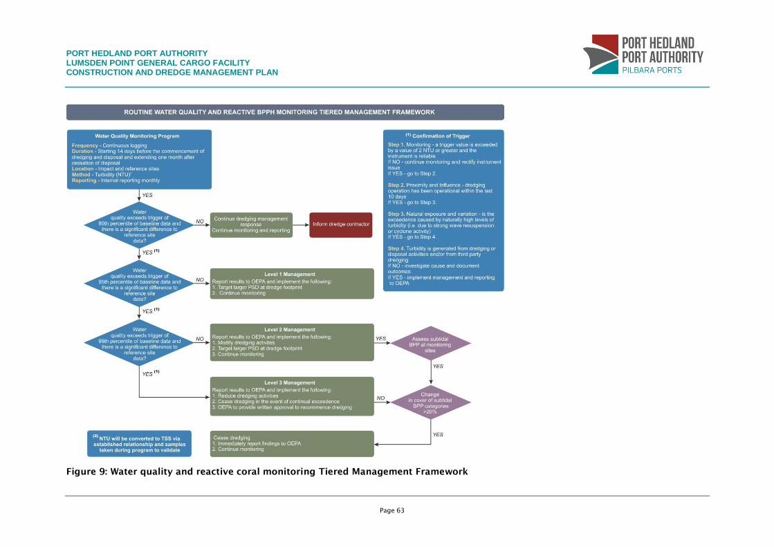
PORT HEDLAND PORT AUTHORITY LUMSDEN POINT GENERAL CARGO FACILITY CONSTRUCTION AND DREDGE MANAGEMENT PLAN
Page 63
Figure 9: Water quality and reactive coral monitoring Tiered Management Framework
PORT HEDLAND PORT AUTHORITY LUMSDEN POINT GENERAL CARGO FACILITY CONSTRUCTION AND DREDGE MANAGEMENT PLAN
Page 64
Figure 10: Routine surface sedimentation monitoring and reactive mangrove health Tiered Management Framework
PORT HEDLAND PORT AUTHORITY LUMSDEN POINT GENERAL CARGO FACILITY CONSTRUCTION AND DREDGE MANAGEMENT PLAN
Page 65
Figure 11: Dewatering Monitoring Tiered Management Framework
PORT HEDLAND PORT AUTHORITY LUMSDEN POINT GENERAL CARGO FACILITY CONSTRUCTION AND DREDGE MANAGEMENT PLAN
Page 66
7.2.2 Monitoring site locations
Three water quality impact sites – South-West Creek (SWC), Stingray Creek (SRC) and South
East Creek (SEC) – have been established within the predicted area to be influenced by
dredging activities (within Port Hedland inner harbour). One reference location has also been
identified to provide comparison of data to monitoring locations during dredging activities
(Table 5). These water quality sites are located in areas where coral communities are found
within the DoE (2006) zone of high level of ecological protection, to ensure sensitive
receptors are not being impacted by the activities.
Table 5 provides the geographic coordinates for each site, data to be collected at each site
and the site’s function adjacent to the dredge footprint.
Table 5: Proposed water quality monitoring sites for dredging
Site name Position (MGA Zone 50) Details
Easting Northing Water quality data collection
Water quality monitoring sites
South West Creek (SWC) 662430 7750687 Telemetry and logging
South East Creek (SEC) 666086 7749980 Telemetry and logging
Stingray Creek (SRC) 666449 7751169 Telemetry and logging
Reference sites
Salmon Creek (SOL) 661272 7751257 Telemetry and logging
Dewatering water quality monitoring sites
South Creek (SCD) 664417 7748194 Telemetry and logging
South Creek 2 (SCD 2) 666417 7748590 Telemetry and logging
South East Creek (SECD) 664824 7748458 Telemetry and logging
Return water from the DMMAs will be discharged to the environment via designated
discharge points (Figure 12). The water quality of return water will be managed and
monitored in order to meet a ‘high’ level of ecological protection in South East Creek and
South Creek (Figure 11).
Potential water quality sites for monitoring of return water discharge are also shown in
Figure 12. Indicative coordinates for sites are shown in Table 5, however these may be
repositioned to find a suitable position for the deployment in order to ensure loggers are
not exposed during periods of low tide.
PORT HEDLAND PORT AUTHORITY LUMSDEN POINT GENERAL CARGO FACILITY CONSTRUCTION AND DREDGE MANAGEMENT PLAN
Page 67
Figure 12: Location of proposed water quality monitoring sites associated with
dredging activities
PORT HEDLAND PORT AUTHORITY LUMSDEN POINT GENERAL CARGO FACILITY CONSTRUCTION AND DREDGE MANAGEMENT PLAN
Page 68
7.2.3 Frequency
Pre dredging
Baseline turbidity data was collected between December 2010 and March 2012 at each site.
This data is considered sufficient for the development of trigger levels to be used during
dredging activities.
During dredging
Data from the telemetered loggers will be evaluated daily during dredging. Management
response actions including subtidal BPP health monitoring will be implemented should
trigger levels be exceeded (trigger response outlined in Figure 9). Routine maintenance of
telemetry loggers will be carried out on a monthly basis or before if a problem with data
collection or accuracy is identified within a specific logger system.
Post dredging
Water quality monitoring data from the loggers will continue to be downloaded until water
quality levels return to pre dredging levels after the cessation of dredging, or one month
following completion of dredging.
7.2.4 Parameters and procedures
Physico-chemical analysis
Turbidity will be measured at monitoring locations associated with dredging activities. At all
locations turbidity data will be collected using in situ water quality loggers with telemetry
capability. Logging systems at the inshore sites will be located approximately 1 m above the
seabed on a steel frame at each specified monitoring location.
For inshore sites, the logger units associated with dredging will be set up to measure
turbidity every 30 minutes.
Data will be downloaded daily using the telemetry system deployed with the logger. Loggers
will be calibrated monthly to ensure accurate datasets are acquired.
Correlation of TSS and NTU
Correlation of TSS and turbidity is undertaken to validate whether predicted zones of impact
from modelling are a true representation of the plume extent during dredging activities.
Water samples will be collected with a 1 L Van Dorn bottle and measured for NTU and TSS
for a single event during the dredging program. Two sites will be selected in the immediate
vicinity of the dredge. Replicated samples will be collected from the surface, mid and
bottom of the water column at each site and analysed for:
TSS (samples sent to the laboratory);
NTU (measured both onsite and with samples being sent to the laboratory); and
particle-size distribution (samples sent to the laboratory).
Samples will be sent to a National Association of Testing Authorities (NATA) accredited
laboratory for quantitative analysis. Results may also be used to compare measured
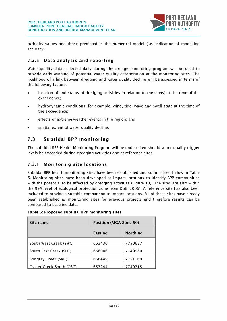
PORT HEDLAND PORT AUTHORITY LUMSDEN POINT GENERAL CARGO FACILITY CONSTRUCTION AND DREDGE MANAGEMENT PLAN
Page 69
turbidity values and those predicted in the numerical model (i.e. indication of modelling
accuracy).
7.2.5 Data analysis and reporting
Water quality data collected daily during the dredge monitoring program will be used to
provide early warning of potential water quality deterioration at the monitoring sites. The
likelihood of a link between dredging and water quality decline will be assessed in terms of
the following factors:
location of and status of dredging activities in relation to the site(s) at the time of the
exceedence;
hydrodynamic conditions; for example, wind, tide, wave and swell state at the time of
the exceedence;
effects of extreme weather events in the region; and
spatial extent of water quality decline.
7.3 Subtidal BPP monitoring
The subtidal BPP Health Monitoring Program will be undertaken should water quality trigger
levels be exceeded during dredging activities and at reference sites.
7.3.1 Monitoring site locations
Subtidal BPP health monitoring sites have been established and summarised below in Table
6. Monitoring sites have been developed at impact locations to identify BPP communities
with the potential to be affected by dredging activities (Figure 13). The sites are also within
the 99% level of ecological protection zone from DoE (2006). A reference site has also been
included to provide a suitable comparison to impact locations. All of these sites have already
been established as monitoring sites for previous projects and therefore results can be
compared to baseline data.
Table 6: Proposed subtidal BPP monitoring sites
Site name Position (MGA Zone 50)
Easting Northing
South West Creek (SWC) 662430 7750687
South East Creek (SEC) 666086 7749980
Stingray Creek (SRC) 666449 7751169
Oyster Creek South (OSC) 657244 7749715
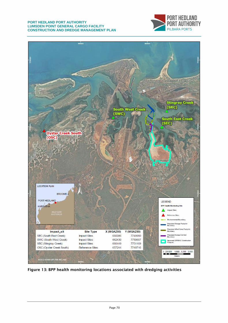
PORT HEDLAND PORT AUTHORITY LUMSDEN POINT GENERAL CARGO FACILITY CONSTRUCTION AND DREDGE MANAGEMENT PLAN
Page 70
Figure 13: BPP health monitoring locations associated with dredging activities
PORT HEDLAND PORT AUTHORITY LUMSDEN POINT GENERAL CARGO FACILITY CONSTRUCTION AND DREDGE MANAGEMENT PLAN
Page 71
7.3.2 Frequency
Phase I – pre dredging
A baseline BPP health survey will be undertaken at least two weeks before dredging begins.
Phase II – during dredging
BPP health will be monitored at identified impact and reference sites following exceedence
of adopted water quality trigger levels (trigger response outlined in Figure 10).
Phase III – post dredging
A post dredging BPP health investigation will be undertaken four weeks following the
completion of dredging to define any impact between pre and post dredging/disposal
activities.
7.3.3 Parameters and procedures
Pre and post dredging surveys will be undertaken to quantify the composition and mean
percent coverage of BPP communities at each site.
Line-intercept surveys
Abundance surveys of the subtidal BPP communities will be made at each site. Four 20 m,
haphazardly positioned, line-intercept transects will run within an area of substratum.
Approximately 50 x 10 m will be recorded at each site to measure cover of the major
benthic organisms in the area of maximum BPP abundance. The transects will be
permanently marked with 12 mm reinforcing rod stakes driven into the bottom at 5 m
intervals. To measure BPP cover, survey tapes will be stretched tightly between the stakes
close to the substratum and the length of the intercept (with the tape of all benthic
organisms directly beneath it) will be measured. Intercept lengths for all colonies of a
species along each transect will then be totalled and converted to a percentage cover
measurement.
These techniques have been used in many other surveys of subtidal BPP communities
(Mapstone, Choat et al. 1989; Ayling and Ayling 1995; Ayling and Ayling 2006).
The bleaching status of all coral intercepts will be noted during these surveys in three
categories: 1. Not bleached; 2. Partially bleached; 3. Totally bleached.
A permanent record will be made of the BPP community along each transect by taking an
overlapping series of high-resolution digital still photographs of a 33 cm wide strip down
the shoreward side of each tape.
Sediment deposition on subtidal BPP (corals)
In addition to measuring the approximate percentage of each BPP colony covered in
sediment, measurements of the maximum depth of sediment will be taken, if present, on
the surface of each tagged BPP colony using a set of callipers.
Wider measures of subtidal BPP health (corals)
Although line-intercept transects give a good estimate of coral cover, the sample size of BPP
colonies immediately beneath the transect lines is not sufficient to encounter relatively rare
PORT HEDLAND PORT AUTHORITY LUMSDEN POINT GENERAL CARGO FACILITY CONSTRUCTION AND DREDGE MANAGEMENT PLAN
Page 72
community events such as BPP disease or to assess small-scale changes in BPP health.
Similarly, the health assessment using 50 tagged corals has only a limited sample size of
colonies. To sample a wider area and a larger number of corals, the following components
will also be measured along a 20 x 2 m strip centred on each transect line:
Counts of the total number of coral colonies in each major coral group or species.
Counts of bleached or partially bleached colonies.
Counts of all sediment-damaged colonies. Many coral colonies have dead patches from
a variety of causes and colonies will not be recorded as damaged if there is an actively
growing edge encroaching into the dead patch.
Counts of all diseased colonies. As for sediment damage, if there is an actively
growing edge reclaiming a disease-caused dead patch that colony will not be recorded
as diseased for that survey.
Counts of all colonies showing recent partial mortality.
Counts of all colonies suffering recent total mortality.
Coral sub-lethal stress
During the baseline, changes in the colour and hence zooxanthellae density of the tagged
corals were used to assess sub-lethal stress. Colour was measured using the underwater BPP
colour chart developed by Siebeck et al. (2006). Colour intensity scores for each tagged
coral were recorded during each survey and these measures will be continued by the current
monitoring team. A shift toward lighter colour intensity would indicate a more stressed
state.
Coral size
The area of each tagged colony was measured during the baseline surveys from the colony
photographs and these measures will be repeated during all ongoing surveys. This will give
some indication of coral growth and hence a measure of the age of the communities. If the
communities are young then this suggests that the habitat is marginal for coral growth and
that colonies suffer regular mortality due to natural causes or past port development
impacts.
7.3.4 Data analysis
Data will be collated within one week of completion of each BPP health investigation. The
significance of any changes in the benthic abundance surveys will be tested using a
repeated measures analysis of variance after each survey. Similar repeated measures tests
will also be used to check the significance of changes in sediment depth on coral colonies
and in the density of damaged BPP colonies.
7.4 Mangrove Health Monitoring Program
Mangrove health has the potential to be adversely affected through smothering of
pneumatophores from increased deposition following re-suspension of dredged sediments.
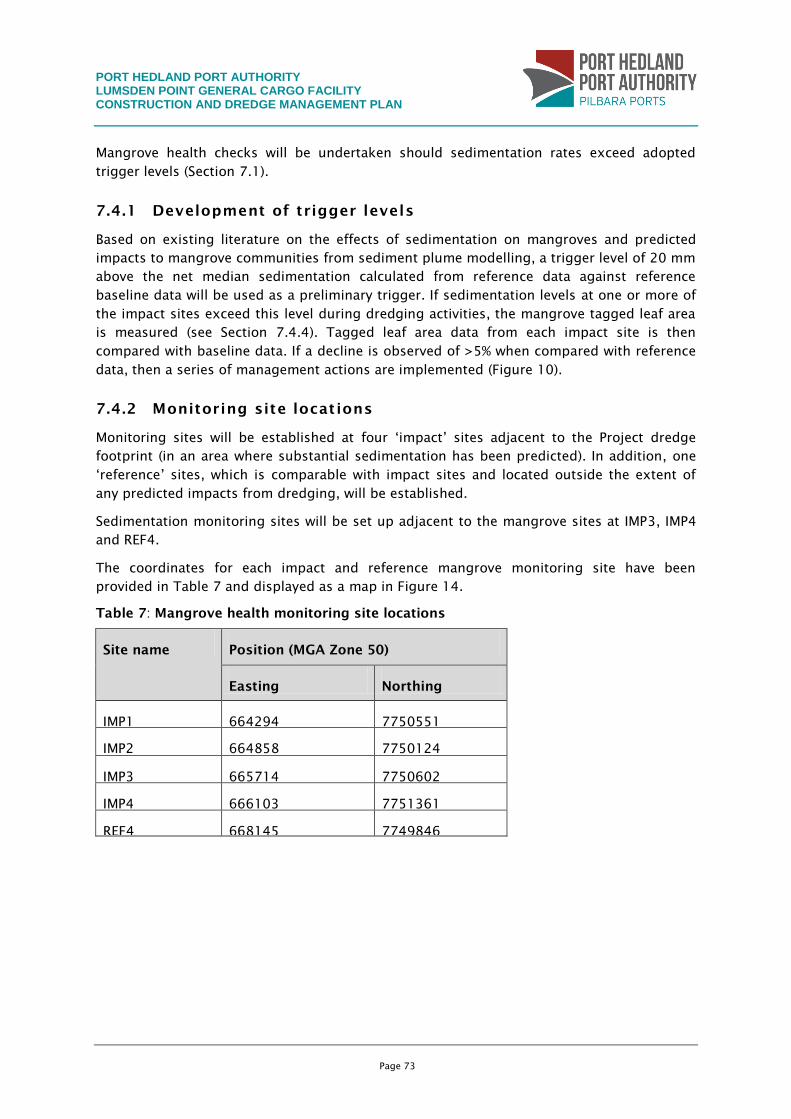
PORT HEDLAND PORT AUTHORITY LUMSDEN POINT GENERAL CARGO FACILITY CONSTRUCTION AND DREDGE MANAGEMENT PLAN
Page 73
Mangrove health checks will be undertaken should sedimentation rates exceed adopted
trigger levels (Section 7.1).
7.4.1 Development of trigger levels
Based on existing literature on the effects of sedimentation on mangroves and predicted
impacts to mangrove communities from sediment plume modelling, a trigger level of 20 mm
above the net median sedimentation calculated from reference data against reference
baseline data will be used as a preliminary trigger. If sedimentation levels at one or more of
the impact sites exceed this level during dredging activities, the mangrove tagged leaf area
is measured (see Section 7.4.4). Tagged leaf area data from each impact site is then
compared with baseline data. If a decline is observed of >5% when compared with reference
data, then a series of management actions are implemented (Figure 10).
7.4.2 Monitoring site locations
Monitoring sites will be established at four ‘impact’ sites adjacent to the Project dredge
footprint (in an area where substantial sedimentation has been predicted). In addition, one
‘reference’ sites, which is comparable with impact sites and located outside the extent of
any predicted impacts from dredging, will be established.
Sedimentation monitoring sites will be set up adjacent to the mangrove sites at IMP3, IMP4
and REF4.
The coordinates for each impact and reference mangrove monitoring site have been
provided in Table 7 and displayed as a map in Figure 14.
Table 7: Mangrove health monitoring site locations
Site name Position (MGA Zone 50)
Easting Northing
IMP1 664294 7750551
IMP2 664858 7750124
IMP3 665714 7750602
IMP4 666103 7751361
REF4 668145 7749846
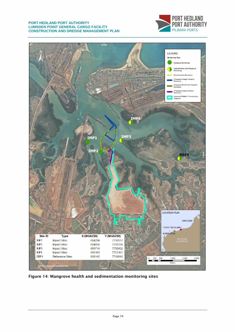
PORT HEDLAND PORT AUTHORITY LUMSDEN POINT GENERAL CARGO FACILITY CONSTRUCTION AND DREDGE MANAGEMENT PLAN
Page 74
Figure 14: Mangrove health and sedimentation monitoring sites
PORT HEDLAND PORT AUTHORITY LUMSDEN POINT GENERAL CARGO FACILITY CONSTRUCTION AND DREDGE MANAGEMENT PLAN
Page 75
7.4.3 Frequency
Mangrove monitoring is proposed to be carried out at the following frequency:
2 weeks before the Project starts;
4 weeks after completion of the Project; and
if sedimentation trigger levels are exceeded, a reactive mangrove health monitoring
survey will be undertaken immediately (or as soon as practicable) after the
exceedence.
Sedimentation levels will be monitored:
continuous in situ measurement (weekly) two weeks before dredging begins;
continuous in situ measurement (weekly) during dredging; and
one month after dredging is finished.
7.4.4 Parameters and procedures
A series of permanent monitoring quadrats will be established in the designated impact and
reference locations. The sites will be selected to encompass both low and high elevations,
and all significant community types. At each site, four randomly located 4 x 4 m quadrats
will be established and marked such that they can be easily revisited.
Qualitative monitoring
Qualitative monitoring of mangrove community health will be achieved using the Duke et al.
(2005) classification system, which determines healthy (green leaves <10% dead/yellowing
leaves), sick (yellow, wilting leaves, approximately 10–50% dead/yellowing leaves) and dead
(>50% dead/yellowing leaves) mangrove characteristics in each monitoring quadrat.
Photographs and a qualitative description of health attributes (e.g. disease) will also be
taken from each monitoring quadrat.
Foliage density
Foliage density is measured using the plant canopy analyser. The LAI-2000 plant canopy
analyser (Li-Cor, Inc., Lincoln, NE) is designed to estimate leaf area index of plant canopies
indirectly from measurements of radiation above and below the canopy, based on a
theoretical relationship between leaf area and canopy transmittance. Its optical sensor
comprises five detectors, arranged in concentric rings that measure radiation (below 490
nm) from different sections of the sky. Canopy transmittance for these different sections is
computed as the ratio between below-canopy and above-canopy readings for each detector
ring. The leaf area estimate is based on the assumption of randomly distributed foliage
elements.
Tagged-branch leaf area
A further measure of short-term mangrove health is gathered through the measurement of
tagged-branch leaf area using a specialised handheld scanning device (measured as leaf area
index). In each monitoring quadrat, five randomly oriented branches are selected and
‘tagged’ for subsequent leaf area analysis. When surveyed, each leaf on each branch is
PORT HEDLAND PORT AUTHORITY LUMSDEN POINT GENERAL CARGO FACILITY CONSTRUCTION AND DREDGE MANAGEMENT PLAN
Page 76
scanned using the handheld device, providing a measurement of area, length, average and
maximum width for each leaf, as well as total leaf area and leaf count for each tagged
branch.
Sedimentation monitoring
Sedimentation levels will be monitored using sedimentation sticks or via similar methods
such as sedimentation scanners. Sedimentation levels will be measured weekly.
Mangrove mapping
Aerial photography will be used to map the distribution, coverage and species composition
of mangrove habitats situated near the Project footprint and in areas of potential indirect
impacts. Aerial photography will be ortho-rectified to allow for determination of mangrove
cover. Field surveys will be used to ground truth the distribution, coverage and species
composition of mangrove community types in areas of change as identified through
comparison of aerial photographs.
Mangrove mapping will be undertaken:
before the Project starts to provide current information on mangrove distribution; and
when the Project is finished.
Mangrove distribution and cover will be compared with the baseline data to confirm that the
area of direct disturbance of mangrove habitat does not exceed the approved loss limit.
7.4.5 Data analysis
Mangrove health
Mangrove health data will be compared between the pre dredging and post dredging
mangrove health surveys to confirm that mangrove health was not affected during dredging
activities. If sedimentation trigger levels are exceeded during dredging activities a mangrove
health survey will be undertaken and compared with baseline survey data. There would be
no need to undertake additional mangrove surveys during dredging activities as
sedimentation has been identified as the primary impact pathway likely to affect mangrove
communities.
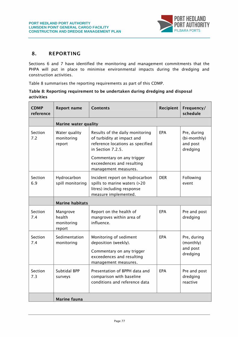
PORT HEDLAND PORT AUTHORITY LUMSDEN POINT GENERAL CARGO FACILITY CONSTRUCTION AND DREDGE MANAGEMENT PLAN
Page 77
8. REPORTING
Sections 6 and 7 have identified the monitoring and management commitments that the
PHPA will put in place to minimise environmental impacts during the dredging and
construction activities.
Table 8 summarises the reporting requirements as part of this CDMP.
Table 8: Reporting requirement to be undertaken during dredging and disposal
activities
CDMP
reference
Report name Contents Recipient Frequency/
schedule
Marine water quality
Section
7.2
Water quality
monitoring
report
Results of the daily monitoring
of turbidity at impact and
reference locations as specified
in Section 7.2.5.
Commentary on any trigger
exceedences and resulting
management measures.
EPA Pre, during
(bi-monthly)
and post
dredging
Section
6.9
Hydrocarbon
spill monitoring
Incident report on hydrocarbon
spills to marine waters (>20
litres) including response
measure implemented.
DER Following
event
Marine habitats
Section
7.4
Mangrove
health
monitoring
report
Report on the health of
mangroves within area of
influence.
EPA Pre and post
dredging
Section
7.4
Sedimentation
monitoring
Monitoring of sediment
deposition (weekly).
Commentary on any trigger
exceedences and resulting
management measures.
EPA Pre, during
(monthly)
and post
dredging
Section
7.3
Subtidal BPP
surveys
Presentation of BPPH data and
comparison with baseline
conditions and reference data
EPA Pre and post
dredging
reactive
Marine fauna
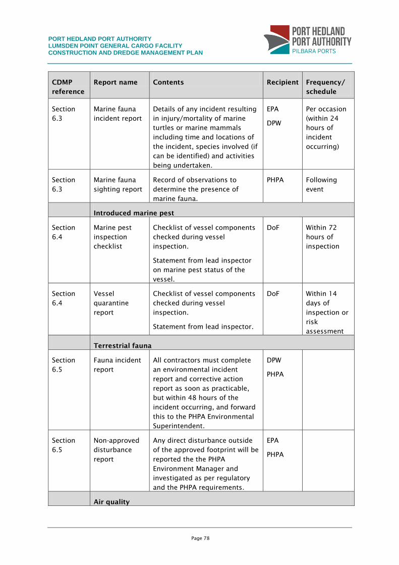
PORT HEDLAND PORT AUTHORITY LUMSDEN POINT GENERAL CARGO FACILITY CONSTRUCTION AND DREDGE MANAGEMENT PLAN
Page 78
CDMP
reference
Report name Contents Recipient Frequency/
schedule
Section
6.3
Marine fauna
incident report
Details of any incident resulting
in injury/mortality of marine
turtles or marine mammals
including time and locations of
the incident, species involved (if
can be identified) and activities
being undertaken.
EPA
DPW
Per occasion
(within 24
hours of
incident
occurring)
Section
6.3
Marine fauna
sighting report
Record of observations to
determine the presence of
marine fauna.
PHPA Following
event
Introduced marine pest
Section
6.4
Marine pest
inspection
checklist
Checklist of vessel components
checked during vessel
inspection.
Statement from lead inspector
on marine pest status of the
vessel.
DoF Within 72
hours of
inspection
Section
6.4
Vessel
quarantine
report
Checklist of vessel components
checked during vessel
inspection.
Statement from lead inspector.
DoF Within 14
days of
inspection or
risk
assessment
Terrestrial fauna
Section
6.5
Fauna incident
report
All contractors must complete
an environmental incident
report and corrective action
report as soon as practicable,
but within 48 hours of the
incident occurring, and forward
this to the PHPA Environmental
Superintendent.
DPW
PHPA
Section
6.5
Non-approved
disturbance
report
Any direct disturbance outside
of the approved footprint will be
reported the the PHPA
Environment Manager and
investigated as per regulatory
and the PHPA requirements.
EPA
PHPA
Air quality
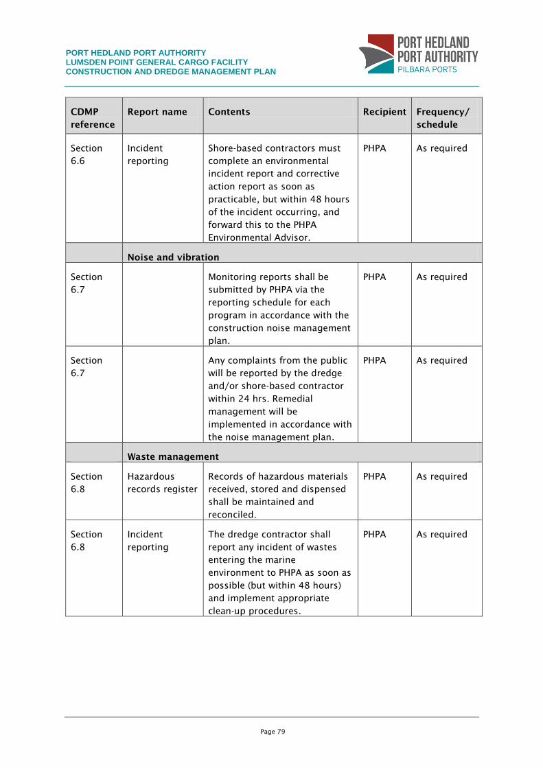
PORT HEDLAND PORT AUTHORITY LUMSDEN POINT GENERAL CARGO FACILITY CONSTRUCTION AND DREDGE MANAGEMENT PLAN
Page 79
CDMP
reference
Report name Contents Recipient Frequency/
schedule
Section
6.6
Incident
reporting
Shore-based contractors must
complete an environmental
incident report and corrective
action report as soon as
practicable, but within 48 hours
of the incident occurring, and
forward this to the PHPA
Environmental Advisor.
PHPA As required
Noise and vibration
Section
6.7
Monitoring reports shall be
submitted by PHPA via the
reporting schedule for each
program in accordance with the
construction noise management
plan.
PHPA As required
Section
6.7
Any complaints from the public
will be reported by the dredge
and/or shore-based contractor
within 24 hrs. Remedial
management will be
implemented in accordance with
the noise management plan.
PHPA As required
Waste management
Section
6.8
Hazardous
records register
Records of hazardous materials
received, stored and dispensed
shall be maintained and
reconciled.
PHPA As required
Section
6.8
Incident
reporting
The dredge contractor shall
report any incident of wastes
entering the marine
environment to PHPA as soon as
possible (but within 48 hours)
and implement appropriate
clean-up procedures.
PHPA As required
PORT HEDLAND PORT AUTHORITY LUMSDEN POINT GENERAL CARGO FACILITY CONSTRUCTION AND DREDGE MANAGEMENT PLAN
Page 80
9. AUDITING
A compliance audit schedule will be developed based on the conditions contained within the
various approvals documents. The PHPA will submit an environmental compliance report to
the EPA as required following approval of the Project.
Each environmental compliance report will address each element of the audit program
approved by the EPA and will be prepared and submitted in a format acceptable to both
organisations.
PORT HEDLAND PORT AUTHORITY LUMSDEN POINT GENERAL CARGO FACILITY CONSTRUCTION AND DREDGE MANAGEMENT PLAN
Page 81
10. REFERENCES
ANZECC (1997). Code of Practice for Antifouling and In-Water Hull Cleaning and
Maintenance.
ANZECC/ARMCANZ (2000). Australian and New Zealand Guidelines for Fresh and Marine
Water Quality.
AQIS (2008). Australian ballast water management requirements. Version 4,.
Ayling, A. M. and A. L. Ayling (1995). A preliminary survey of benthic communities on
fringing reefs in the middle Cairns Section. Unpublished report submitted to the Great
Barrier Reef Marine Park Authority.
Ayling, A. M. and A. L. Ayling (2006). The dynamics of Cairns and Central Section Fringing
Reefs. Unpublished report submitted to the Great Barrier Reef Marine Park Authority.
BHP (2008). Harriet Point Dredging Environmental Referral Document. Unpublished Report.
BHPBIO (2008). Harriet Point Environmental Referral Document.
BHPBIO (2009). Environmental Referral Document - Nelson Point Dredging, RGP6 Port
Development, Port Hedland. Assessment on Referred Information.
BHPBIO (2010). RGP6 Definition Phase Inner Harbour Geotechnical Investigation.
Implementation of the Environmental Sampling Programme - Hunt Point Load Out Facility,
Prepared for BHPBIO by WorleyParsons.
Coffey (2008). Factual Report on Geotechnical Investigation Hunt Point, Port Hedland,
GEOTHERDO6703AU-AB, 15 December 2008.
Commonwealth Government of Australia (1992a). Intergovernmental Agreement on the
Environment, Department of the Arts, Sport, Environment & Territories. Canberra, Australian
Capital Territory.
Commonwealth Government of Australia (1992b). National Strategy for Ecologically
Sustainable Development, AGPS. Canberra, Australian Capital Territory.
Commonwealth Government of Australia (1992c). National Water Quality Management
Strategy.
Commonwealth of Australia (1996). National Strategy for the Conservation of Australia's
Biological Diversity, Department of the Environment, Sport and Territories. Canberra
Australian Capital Territory.
DAFF (2009a). National Biofouling Management Guidance for Commercial Vessels.
DAFF (2009b). National Biofouling Management Guidance for Non-trading Vessels.
DEC (2006). Background quality of the marine sediments of the Pilbara coast. Marine
Technical Report Series 1.
DEC (2013). Identification and investigation of acid sulfate soils and acidic landscapes,
Department of Environment and Conservation.
Department of Environment and Heritage (2006). Australian National Guidelines for Whale
and Dolphin Watching 2005, Department of the Environment and Heritage: 20.
Digimizer (2011). www.digimizer.com. MedCalc Software.
Dix, G. R. (1989). "High-energy, inner shelf carbonate facies along a tide-dominated non-
rimmed margin, northwestern Australia." Marine Geology 89(3-4): 347-362.
PORT HEDLAND PORT AUTHORITY LUMSDEN POINT GENERAL CARGO FACILITY CONSTRUCTION AND DREDGE MANAGEMENT PLAN
Page 82
DoE (2006). Pilbara Coastal Water Quality Consultation Outcomes: Environmental Values and
Environmental Quality Objectives. Western Australia.
DSD (2010). Port Hedland Air Quality and Noise Management Plan - The Port Hedland Dust
Management Taskforce Report. D. o. S. Development. Perth, Western Australia.
Duke, N., A. Bell, et al. (2005). "Herbicides implicated as the cause of severe mangrove
dieback in the Mackay region, NE Australia - serious implications for marine plant habitats of
the GBR World Heritage Area." Marine Pollution Bulletin(51): 308-324.
EPA (2001). Guidance Statement for protection of tropical arid zone mangroves along the
Pilbara coastline, No. 1. Guidance for the Assessment of Environmental Factors Western
Australia (in accordance with the Environmental Protection Act 1986). Environmental
Protection Authority.
EPA (2003). Guidance Statement No. 55: Implementing Best Practice in proposals submitted
to the Environmental Impact Assessment Process. Perth, WA, Environmental Protection
Authority.
EPA (2004). Guidance Statement 41: Assessment of Aboriginal Heritage. Guidance for the
Assessment of Environmental Factors Western Australia (in accordance with the
Environmental Protection Act 1986), Environmental Protection Authority. No. 41, Final.
EPA (2007). Guidance Statement 8: Environmental Noise (Draft). Guidance Statements. Perth,
WA, Environment Protection Authority.
EPA (2009a). Environmental Assessment Guideline 3 (EAG3): Protection of Benthic Primary
Producer Habitats in Western Australia's Marine Environment. Perth, WA, Environmental
Protection Authority.
EPA (2009b). Environmental Protection Bulletin No.2 - Port Hedland Noise and Dust.
Environmental Protection Authority
EPA (2009c). Nelson Point Dredging RGP6 Port Development, Port Hedland: Report and
recommendations of the Environmental Protection Authority. Report No 1337.
EPA (2011a). Environmental Assessment Guideline for Marine Dredging Proposals No.7.
(EAG7).
EPA (2011b). Environmental Protection Bulletin No.14: Guidance for the assessment of
benthic primary producer habitat loss in and around Port Hedland, Environmental Protection
Authority, Western Australia.
FMG (2011). South West Creek SAP implementation report for Heavy Load Out Facility
Prepared by WorleyParsons.
GHD (2007). Long Term Dredge Material Management Plan.
GHD (2012). Pilbara Fabrication and Services Common Use Facility: Market Demand Study
(Executive Summary) for Department of Commerce.
Halpern Glick Maunsell (1997). Port Hedland Port Developments Environmental Study. Report
prepared for Port Hedland Port Authority.
Hickman, A. and D. Gibson (1982). Explanantory notes on the Port Hedland - Bedout Island
Geological Sheet (Second Edition). Bureau of Mineral Resources, Australia and Geological
Survey of WA.
Hope Downs Management Services (2002). Hope Downs Iron Ore Project - Port and Rail -
Public Environmental Review.
Koskela (2007). Port of Port Hedland Maintenance Dredging Campaign 2008 - Sediment
Sampling and Analysis Report. Report prepared by Koskela Group for Port Hedland Port
Authority.
PORT HEDLAND PORT AUTHORITY LUMSDEN POINT GENERAL CARGO FACILITY CONSTRUCTION AND DREDGE MANAGEMENT PLAN
Page 83
Mapstone, D. D., J. H. Choat, et al. (1989). The fringing reefs of Magnetic Island: Benthic
biota and sedimentation – a baseline survey. Unpublished report to the Great Barrier Reef
Marine Park Authority.
McArthur, C., M. Asce, et al. (2002). Development of guidelines for dredged material
disposal based on abiotic determinants of coral reef community structure. Proc. 7th Int.
Coral Reef Symp.
McLoughlin, R. and P. Young (1985). "Sedimentary provinces of the fishing grounds of the
North West Shelf of Australia: Grain-size frequency analysis of surficial sediments."
Australian Journal of Marine and Freshwater Research 36(5): 671 - 681.
National Oceanic and Atmospheric Administration (2006). Small Diesel Spills (500-5000
gallons).
Oceanica (2005). Pilbara Iron Ore and Infrastructure Project: Sediment Contaminants and
Acid Sulphate Soils. , Report prepared for Fortescue Metals Group Ltd. Report no. 423/2.
Oceanica (2010). "A review of Introduced Marine Pest Knowledge for Port Hedland, Western
Australia." Unpublished report for PHPA.
Paling, E., G. Humphries, et al. (2003). "The Effect of Harbour Development on Mangroves in
Northwestern Australia " Wetlands Ecology and Management, 54, : 281-290.
Paling, E. I., A. J. McComb, et al. (1989). "Nitrogen fixation (acetylene reduction) in
nonheterocystous cyanobacterial mats from the Dampier Archipelago, Western Australia."
Australian Journal of Marine and Freshwater Research 40(2 ).
PHPA (2003). "Port Hedland Port Authority Environmental Management Plan. January 2003.".
PHPA (2006). Annual Environmental Management Plan.
PHPA (2010). Port Hedland Port Authority - South West Creek Tug and Small Vessel Cyclone
Protection Mooring Facility - Referral Information, Report prepared by WorleyParsons on
behalf of Port Hedland Port Authority.
PHPA (2012). PHPA Dust Management Guidelines: Leading Practice. Doc. EH009.
Port Hedland Port Authority (2003). Annual Environmental Management Plan.
Prince, R. I. T. (2001). Aerial Survey of the Distribution and Abundance of Dugongs and
Associated Macrovertebrate Fauna - Pilbara Coastal and Offshore Region, WA. . Report
prepared for Environment Australia.
Saenger, P. (2002). Mangrove Ecology. Silviculture and Conservation.
Semeniuk, V. (1993). "The Pilbara Coast: a riverine coastal plain in a tropical arid setting,
northwestern Australia." Sedimentary Geology 83(3-4): 163-358.
Semeniuk, V., P. N. Chalmer, et al. (1982). "The marine environments of the Dampier
Archipelago." Journal of the Royal Society of Western Australia, 65 (3): 97-114.
Siebeck, U., N. Marshall, et al. (2006). "Monitoring coral bleaching using a colour reference
card." Coral Reefs 25: 453-460.
SKM (2002). Sampling and Analysis Program Data Report. Products and Capacity Expansion
(PACE) Project. Prepared for the Mine and Port Developments Joint Venture on behalf of BHP
Billiton Iron Ore.
SKM (2009). RGP6 Subtidal BPPH Report. Perth, SKM Report Prepared for BHP Billiton Iron
Ore.
Talbot, V. and S. Creagh (1985). Mineralogical variation within the marine sediments of the
Dampier region: a dynamic approach. Department of Conservation and Environment Western
Australia.
PORT HEDLAND PORT AUTHORITY LUMSDEN POINT GENERAL CARGO FACILITY CONSTRUCTION AND DREDGE MANAGEMENT PLAN
Page 84
URS (2003). Port Hedland Port Authority Sampling and Analysis Plan for Maintenance
Dredging. Report prepared for Port Hedland Port Authority.
URS (2004). Port Hedland Harbour and Shipping Channel Sediment Quality Report prepared
for Port Hedland Port Authority.
URS (2008). Sediment sampling for proposed fourth and fifth berths, Port Hedland Harbour,
Report prepared by URS for the Fortescue Metals Group Ltd.
WAPC (2003). Western Australian Planning Commission Port Hedland Area Planning Study.
Wenziker, K., K. McAlpine, et al. (2006). Background Quality for Coastal Marine Waters of
the North West Shelf, Western Australia. NWSJEMS Technical Report No.18.
WorleyParsons (2010a). Marine Pest Survey in South West Creek. Technical appendix to EIA,
Prepared by WorleyParsons for PHPA.
WorleyParsons (2010b). RGP6 Definition Phase - Inner Harbour Geotechnical Investigation.
Factual Report - Implementation of the Environmental Sampling Programme -Lumsden Point
Tug Harbour.
WorleyParsons (2010c). South West Creek Dredging Approvals - Benthic Primary Producer
Habitat Mapping.
WorleyParsons (2012a). Lumsden Point General Cargo Facility - Terrestrial Flora and Fauna
Report. Unpublished report prepared for Port Hedland Port Authority.
WorleyParsons (2012b). South West Creek Dredging and Reclamation Project. Benthic
Primary Producer Habitat Survey and Cumulative Loss Assessment: Port Hedland Local
Assessment Unit (in draft). Prepared for Port Hedland Port Authority.
WorleyParsons (2012c). Stingray Creek Small Vessel Cyclone Mooring Facility Project -
Baseline Water Quality Report.
WorleyParsons (2013a). Lumsden Point - Environmental Impact Assessment: Sediment Plume
Dispersion Study for EIA (in draft) for Port Hedland Port Authority.
WorleyParsons (2013b). Lumsden Point General Cargo Wharf Facility - Ecosystem and
Cumulative Impact Assessment Report. Unpublished report prepared for Port Hedland Port
Authority.