Lower San Gabriel and Los Angeles River Watershed
37
Lower San Gabriel and Los Angeles River Watershed Greater Los Angeles Integrated Regional Water Management Plan November 17, 2008, 9:00 a.m. to 3:00 p.m. Central Basin Offices, Main Conference Room Present: Art Aguilar, Central Basin MWD John Biggs, Brown and Caldwell Shirley Birosik, RWQMB Angela D’Arcy, EJCW George De La O, Los Angeles County Flood Control District Scott Dellinger, Brown and Caldwell David Hill, Central Basin MWD Alex Kenefick, LASGRWC Frank Kuo, Los Angeles County Flood Control District Paul Kuykendall, City of Lakewood Wendy La, Los Angeles County Department of Public Works Eric Leung, Long Beach Water Department Sarina Morales-Choak, City of Santa Fe Springs Beatrice Musacchia, Orange County Public Works Ted Peng, DTSC Groundwater Team Daniel Sharp, Los Angeles County Department of Public Works Bob Siemak, Water Replenishment District Brian Smith, City of Bellflower Ted Spaseff, City of Santa Fe Springs Scott Warren, DTSC Groundwater Team Patricia Wood, Los Angeles County Flood Control District Tim Worley, RMC Theresa Wu, Water Replenishment District Mary Zauner, Los Angeles County Sanitation District Topic/Issue Discussion Action/ Follow up 1. Welcome, Introductions and Purpose Art Aguilar opened the meeting at 9:15 a.m. with Introductions No Action 2. Discussion: Membership of LSGLA Stakeholders Committee – Environmental Justice Coalition for Water Scott Dellinger reviewed the discussion at the previous Steering Committee regarding adding the Environmental Justice Coalition for Water as a voting member of the Steering Committee. The discussion was table to the next Steering Committee Meeting. Discussion on EJCW table to next meeting. 3. Review/Approve October 20, 2008 Steering Committee Meeting Notes The minutes from the October Steering Committee Meeting were distributed. The Committee reviewed and approved the minutes. Minutes Approved. 4. Update on October 22, 2008 Leadership Committee Meeting Leadership Committee minutes from October will be distributed when they are finalized. No Action 5. Review November 26, The Leadership Committee Meeting will be held on November 26 th . The agenda will be No Action The Mission of the Greater Los Angeles IRWMP is to address the water resources needs of the Region in an integrated and collaborative manner.
Transcript of Lower San Gabriel and Los Angeles River Watershed

Lower San Gabriel and Los Angeles River Watershed Greater Los Angeles Integrated Regional Water Management Plan
November 17, 2008, 9:00 a.m. to 3:00 p.m. Central Basin Offices, Main Conference Room
Present: Art Aguilar, Central Basin MWD John Biggs, Brown and Caldwell Shirley Birosik, RWQMB Angela D’Arcy, EJCW George De La O, Los Angeles County
Flood Control District Scott Dellinger, Brown and Caldwell David Hill, Central Basin MWD Alex Kenefick, LASGRWC Frank Kuo, Los Angeles County Flood
Control District
Paul Kuykendall, City of Lakewood Wendy La, Los Angeles County
Department of Public Works Eric Leung, Long Beach Water Department Sarina Morales-Choak, City of Santa Fe
Springs Beatrice Musacchia, Orange County Public
Works Ted Peng, DTSC Groundwater Team Daniel Sharp, Los Angeles County
Department of Public Works
Bob Siemak, Water Replenishment District Brian Smith, City of Bellflower Ted Spaseff, City of Santa Fe Springs Scott Warren, DTSC Groundwater Team Patricia Wood, Los Angeles County Flood
Control District Tim Worley, RMC Theresa Wu, Water Replenishment District Mary Zauner, Los Angeles County
Sanitation District
Topic/Issue Discussion Action/ Follow up
1. Welcome, Introductions and Purpose
Art Aguilar opened the meeting at 9:15 a.m. with Introductions No Action
2. Discussion: Membership of LSGLA Stakeholders Committee – Environmental Justice Coalition for Water
Scott Dellinger reviewed the discussion at the previous Steering Committee regarding adding the Environmental Justice Coalition for Water as a voting member of the Steering Committee. The discussion was table to the next Steering Committee Meeting.
Discussion on EJCW table to next meeting.
3. Review/Approve October 20, 2008 Steering Committee Meeting Notes
The minutes from the October Steering Committee Meeting were distributed. The Committee reviewed and approved the minutes.
Minutes Approved.
4. Update on October 22, 2008 Leadership Committee Meeting
Leadership Committee minutes from October will be distributed when they are finalized. No Action
5. Review November 26, The Leadership Committee Meeting will be held on November 26th. The agenda will be No Action
The Mission of the Greater Los Angeles IRWMP is to address the water resources needs of the Region in an integrated and collaborative manner.

2008 Leadership Committee Agenda
distributed when it is finalized.
6. Watershed Coalition of Ventura County and Upper Santa Clara River Watershed Meeting
No updates at this time. No Action
7. DAC Outreach Ad Hoc Committee (update of activities)
No updates at this time. No Action
8. 2008 Consultant Activities
a. Water Supply Gap Analysis
Scott Dellinger reviewed the response to the following question from Long Beach Water on the Water Supply Gap Analysis: “In reviewing the DRAFT 2008 IRWMP Water Supply Gap Analys, I have a comment. In table 4, it identified MWD water sources and the GLACO share, such as 940,000 AF of In-Basin Surface Water Storage, of which our share is 47%, or 442,000. However, I believe this is MWD's current total amount of surface water storage which is not reserved for emergencies. Therefore, in Table 6 in a Worst 3-Year scenario this number should be divided by 3 to get the annual supply for a 3-year scenario. It does not appear that this was done. The same should be done with In-Basin Groundwater Storage and Central Valley Storage. The assumption that MWD would use all of it's storage in a single worst year is also not correct, if that's what was assumed. I have argued recently that they should draw these accounts down over 5 years or more, although they probably still assume a 3-year draw.” And response: “this issue arises from the perception by some that the use of the “Worst 3-Year” SWP hydrology would result in the development of a range of targets under multiple hydrologies rather than a sensitivity analysis under the hydrology used in the MWD IRP. The scope of work states that (t)he water supply planning target would be updated in light of recent SWP delivery reductions. As stated in the memo, the steps undertaken for this update were: 1. Determine GLACO’s portion of the Metropolitan Water District’s (MWD) Integrated Water Resources Plan (IRP) targets for each supply type based on GLACO’s percentage of the MWD’s demands. 2. Determine the Region’s current supplies by supply type under six supply scenarios. 3. For each scenario, calculate the gap between GLACO’s supply targets and current local and imported supplies At the first conference call regarding the update in March, we presented the Leadership Committee representatives with a series of six SWP hydrologies to be used in a sensitivity
No Action
The Mission of the Greater Los Angeles IRWMP is to address the water resources needs of the Region in an integrated and collaborative manner.

analysis of the impacts to the GLACO Supply Targets from a range of “currently available” SWP supplies under Step 2 of the analysis. These hydrologies were selected based on (1) their common usage in urban water management plans and (2) their being recently updated as part of the DWR SWP Reliability Report. While two of the scenarios were based on amounts available from the SWP under the “Worst 3-Year” hydrology on the SWP, which is now the biggest challenge for Metropolitan given the impacts on storage operations resulting from the Delta restrictions, these were simply commonly referenced hydrologies used as part of the sensitivity analysis. This analysis was not intended to develop a range of targets under multiple hydrologies. To do that, we would need to develop the appropriate linked demands and supply targets for all supply types under all six hydrologies, which is outside the scope of this effort. “
9. Other Items No Items. No Action
10. Project Integration a. Discussion of active and
archived projects b. Finalization of Active Project
List and Archived Project List
c. Project Integration Opportunities
d. Disadvantaged Community Projects
e. Selection of Projects for Presentation at January 12, 2009 Project Integration Workshop
f. Finalization of Project Integration Workshop Agenda
Goal of the exercise is to work towards selecting projects for presentation at the Project Integration Workshop. In regards to eventual project selection the following issues were discussed:
• What is the schedule for project selection, specifically the deadlines for project selection.
• How is the Leadership Committee going to use the project rankings from the Steering Committees to select projects for a grant funding applications.
• What affect will the Leadership Committee have on the project selection process, specifically in regards to the three pots of money for the water conservation projects, DAC projects, and other IRWMP projects.
• There should be a focus on the projects that the sponsoring agencies/organizations view as important.
• There should be the opportunity to collaborate on projects to make larger projects that provide multiple benefits and benefit multiple communities, agencies and organizations.
In the interest of time, the City of Long Beach stated that they would be willing to pass over discussion on all inactive Long Beach projects during the meeting leaving them on the inactive list provided that the projects would remain in the IRWM Plan.
11. Meeting Adjourn Meeting Adjourned at 2:30 p.m. Next Meetings: Lower SGLA Steering Committee & Workshop: Central Basin Office, Monday,
Monday, January 12, 2008, 9:00 a.m. – 3:00 p.m. LA IRWMP Leadership Committee: Los Angeles County Public Works, Wednesday,
Wednesday, November 26, 2008, 9:30 a.m. – 12:00 p.m.
December Steering Committee and Leadership Committee Meeting Cancelled.
The Mission of the Greater Los Angeles IRWMP is to address the water resources needs of the Region in an integrated and collaborative manner.


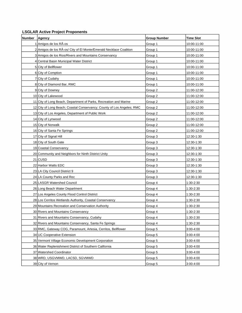
LSGLAR Active Project ProponentsNumber Agency Group Number Time Slot
1 Amigos de los RÃ-os Group 1 10:00-11:00
2 Amigos de los RÃ-os/ City of El Monte/Emerald Necklace Coalition Group 1 10:00-11:00
3 Amigos de los Rios/Rivers and Mountains Conservancy Group 1 10:00-11:00
4 Central Basin Municipal Water District Group 1 10:00-11:00
5 City of Bellflower Group 1 10:00-11:00
6 City of Comption Group 1 10:00-11:00
7 City of Cudahy Group 1 10:00-11:00
8 City of Diamond Bar, RMC Group 1 10:00-11:00
9 City of Downey Group 2 11:00-12:00
10 City of Lakewood Group 2 11:00-12:00
11 City of Long Beach, Department of Parks, Recreation and Marine Group 2 11:00-12:00
12 City of Long Beach; Coastal Conservancy; County of Los Angeles; RMC Group 2 11:00-12:00
13 City of Los Angeles, Department of Public Work Group 2 11:00-12:00
14 City of Lynwood Group 2 11:00-12:00
15 City of Norwalk Group 2 11:00-12:00
16 City of Santa Fe Springs Group 2 11:00-12:00
17 City of Signal Hill Group 3 12:30-1:30
18 City of South Gate Group 3 12:30-1:30
19 Coastal Conservancy Group 3 12:30-1:30
20 Community and Neighbors for Ninth District Unity Group 3 12:30-1:30
21 CUSD Group 3 12:30-1:30
22 Harbor Watts EDC Group 3 12:30-1:30
23 LA City Council District 9 Group 3 12:30-1:30
24 LA County Parks and Rec Group 3 12:30-1:30
25 LASGR Watershed Council Group 4 1:30-2:30
26 Long Beach Water Department Group 4 1:30-2:30
27 Los Angeles County Flood Control District Group 4 1:30-2:30
28 Los Cerritos Wetlands Authority, Coastal Conservancy Group 4 1:30-2:30
29 Mountains Recreation and Conservation Authority Group 4 1:30-2:30
30 Rivers and Mountains Conservancy Group 4 1:30-2:30
31 Rivers and Mountains Conservancy, Cudahy Group 4 1:30-2:30
32 Rivers and Mountains Conservancy, Santa Fe Springs Group 4 1:30-2:30
33 RMC, Gateway COG, Paramount, Artesia, Cerritos, Bellflower Group 5 3:00-4:00
34 UC Cooperative Extension Group 5 3:00-4:00
35 Vermont Village Economic Development Corporation Group 5 3:00-4:00
36 Water Replenishment District of Southern California Group 5 3:00-4:00
37 Watershed Coordinator Group 5 3:00-4:00
38 WRD, USGVMWD, LACSD, SGVMWD Group 5 3:00-4:00
39 City of Vernon Group 5 3:00-4:00

Draft IRWM Regional Acceptance Process Guidelines For 30-Day Public Comment Starting December 22, 2008
Page 1 of 12
RREEGGIIOONN AACCCCEEPPTTAANNCCEE PPRROOCCEESSSS AA CCOOMMPPOONNEENNTT OOFF TTHHEE IINNTTEEGGRRAATTEEDD RREEGGIIOONNAALL WWAATTEERR MMAANNAAGGEEMMEENNTT
PPRROOGGRRAAMM GGUUIIDDEELLIINNEESS
Purpose This document is a component of the Integrated Regional Water Management (IRWM) Program Guidelines. It presents the California Department of Water Resources’ (DWR) Region Acceptance Process (RAP) that will be used to evaluate and accept an IRWM region into the IRWM grant program, California Water Code (CWC) §10541(f) (effective March 1, 2009). Acceptance and approval of the composition of an IRWM region into the IRWM grant program will be required before any region can submit an application for IRWM grant funds. DWR has not previously reviewed and accepted any region, therefore, this process applies to all IRWM regions, both existing and developing. DWR will conduct the RAP on, at least, an annual basis. Timing of the annual RAP review may be coordinated with any upcoming grant solicitation cycle. This opportunity will be given again to those regions that could not apply or were not approved the first time.
Background Since the inception of the IRWM grant program, DWR has encouraged and supported the formation of self-determined IRWM regions. However, effective guidance in IRWM region development has been challenging, because there is no single physical size, organizational structure, or governance definition that applies uniformly to all areas in the state. IRWM regions are dynamic and evolving and as IRWM regions change, it is important that those changes be understood at local and state levels and that the changes work toward the goals of better regional management.
In September 2008, SB 1 (Perata, Stats. 2008, Ch. 1; eff. March 1, 2009) was signed by Governor Schwarzenegger. SB1 contains the “Integrated Regional Water Management Planning Act”, CWC §10530 et seq. The IRWM Planning Act provides a general definition of an IRWM plan as well as guidance to DWR as to what IRWM program guidelines must contain. CWC §10541(f) states that the guidelines shall include standards for identifying a region for the purposes of developing or modifying an IRWM plan. This section also directs DWR to develop a process to approve the composition of the region for the purposes of Proposition 84 IRWM Program. At a minimum, a region is defined as a contiguous geographic area encompassing the service areas of multiple local agencies; is defined to maximize the opportunities to integrate water management activities; and effectively integrates water management programs and projects within a hydrologic region defined in the California Water Plan, the Regional Water Quality Control Board (RWQCB) region, or subdivision or other region specifically identified by DWR (Public Resource Code §75026.(b)(1)).
Equally important to the region boundary is how the IRWM region develops and implements its governance structure and stakeholder involvement functions. A Regional Water Management Group (RWMG) is a group of three or more local agencies, at least two of which have statutory authority over water supply or management, as well as those other persons necessary for the development and implementation of a plan (CWC §10539). This definition acknowledges multiple perspectives on water management and requires collaborative involvement of multiple
Draft IRWM Regional Acceptance Process Guidelines For 30-Day Public Comment Starting December 22, 2008
Page 2 of 12
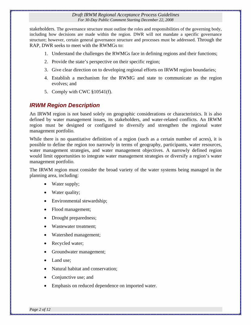
stakeholders. The governance structure must outline the roles and responsibilities of the governing body, including how decisions are made within the region. DWR will not mandate a specific governance structure; however, certain general governance structure and processes must be addressed. Through the RAP, DWR seeks to meet with the RWMGs to:
1. Understand the challenges the RWMGs face in defining regions and their functions;
2. Provide the state’s perspective on their specific region;
3. Give clear direction on to developing regional efforts on IRWM region boundaries;
4. Establish a mechanism for the RWMG and state to communicate as the region evolves; and
5. Comply with CWC §10541(f).
IRWM Region Description An IRWM region is not based solely on geographic considerations or characteristics. It is also defined by water management issues, its stakeholders, and water-related conflicts. An IRWM region must be designed or configured to diversify and strengthen the regional water management portfolio.
While there is no quantitative definition of a region (such as a certain number of acres), it is possible to define the region too narrowly in terms of geography, participants, water resources, water management strategies, and water management objectives. A narrowly defined region would limit opportunities to integrate water management strategies or diversify a region’s water management portfolio.
The IRWM region must consider the broad variety of the water systems being managed in the planning area, including:
• Water supply;
• Water quality;
• Environmental stewardship;
• Flood management;
• Drought preparedness;
• Wastewater treatment;
• Watershed management;
• Recycled water;
• Groundwater management;
• Land use;
• Natural habitat and conservation;
• Conjunctive use; and
• Emphasis on reduced dependence on imported water.

Draft IRWM Regional Acceptance Process Guidelines For 30-Day Public Comment Starting December 22, 2008
Page 3 of 12
IRWM Region Characteristics Functional, successful regions will typically be composed of numerous, diverse stakeholders that manage, direct, or are involved in processes that influence regional water management.
Desirable Characteristics of an IRWM Region The following is a listing of some of the desirable characteristics of an IRWM Region that DWR will continue to encourage.
• The IRWM region is the largest defined contiguous geographic area encompassing the service areas of multiple local agencies, and it is defined to maximize opportunities to integrate water management activities related to natural and man-made water system(s), including water supply reliability, water quality, environmental stewardship; and flood management.
• The IRWM region is inclusive and utilizes a collaborative, multi-stakeholder process that provides mechanisms to assist disadvantaged communities (DAC); address water management issues; and develop integrated, multi-benefit, regional solutions that incorporate environmental stewardship to implement the IRWM plan.
• The IRWM region encompasses a water system containing natural and man-made components with diverse water management issues that are included in a single collaborative water management portfolio, prioritized on regional goals and objectives.
• The IRWM region should demonstrate a reasonable and effective governance structure for developing and implementing its IRWM plan.
Undesirable Characteristics of an IRWM Region The following is a summary of some of the undesirable characteristics of an IRWM Region that DWR does not encourage.
• Multiple IRWM regions in the same geographic area all planning to manage the same water system.
• A region that is solely defined by a jurisdictional boundary, county line, or other geopolitical boundary, without consideration of watershed boundaries or physical location of water resources and infrastructure.
• A region that is formed for the sole purpose of seeking short-term grant funds rather than to sustain a long-term regional planning effort to ensure water supply reliability, water quality, environmental stewardship, and flood management.
• A region that is project driven where existing projects are the primary focus and collaborative integrated regional planning and management is secondary.
• A region where the boundaries tend to exclude rather than include other water management entities and stakeholders.

Draft IRWM Regional Acceptance Process Guidelines For 30-Day Public Comment Starting December 22, 2008
Page 4 of 12
Who Should Submit? Any RWMG should submit RAP materials if it anticipates applying for grant funding from DWR’s IRWM grant program which includes funding from Proposition 84 IRWM funds, Proposition 1E stormwater flood management funds, or other IRWM funds that may be available in the future. The requested information should be submitted by a local agency or non-profit organization.
What to Submit The RWMG shall submit RAP materials in the form of written text, maps, figures, and tables that thoroughly demonstrate that the IRWM region is the most comprehensive, contiguous area defined by common water management issues related to the water system(s) both natural and man-made, including water supply, water quality, environmental stewardship, and flood management.
DWR understands that some regions may be in the initial developmental process and other regions may have more fully developed IRWM planning efforts. A developing IRWM region and an established region may have differing abilities to provide information about their IRWM region. In these cases, the developing region may only be able to provide a conceptual discussion and limited supporting information regarding the composition of the IRWM region. The RAP materials must provide the information necessary to justify and support the proposed region boundary. Use of pre-existing documents is encouraged and the RWMG may extract the relevant information into the RAP materials. The RAP materials should be a stand-alone document that thoroughly supports the basis for the proposed region boundary.
Table 1 lists and describes the items RWMG must submit for the RAP. Corresponding reviewer information is also provided to clarify how the submittal material will be evaluated. See Table 1.

Draft IRWM Regional Acceptance Process Guidelines For 30-Day Public Comment Starting December 22, 2008
Page 5 of 12
IRWM RAP Review Steps The following flow diagram provides an overview of the RWMG submittal and acceptance process:
N
o
t
R
e
c
o
m
m
e
n
d
e
d
Step 1: Applicant submits material to DWR
Step2: DWR reviews information, selects regions for interview, and develops discussion points for the interview.
Step 3: DWR schedules one presentation by the applicant and conducts interview.
DWR concurs with region definition and/or provides additional suggestions to the RWMG for improvement. DWR makes draft recommendations.
Step 4: DWR provides public comment period on draft recommendations, holds a public meeting, and considers comments.
DWR Director issues final decision.

Draft IRWM Regional Acceptance Process Guidelines For 30-Day Public Comment Starting December 22, 2008
Page 6 of 12
Step 1 – Submission of RAP material RWMG submits materials to DWR, as described in “What to Submit” Section.
Step 2 – DWR reviews RAP material DWR will review the RAP material and make one of the following determinations:
1. Application Not Recommended. The information presented does not meet basic eligibility requirements to reasonably support the concepts and basis for the proposed IRWM Region Boundary. The agencies in this category will not be invited to the region acceptance process interview.
2. Application Recommended. DWR will notify the applicant and schedule an initial applicant interview with the RWMG. DWR will prepare a list of questions or discussion points regarding the questionnaire responses. An email with the questions/discussion points will be sent to the point-of-contact listed in Question 1. DWR may request minor revisions or clarification or submittal of additional material for the RAP interview (discussed in Step 3). The email will also provide the time and location of the interview.
Step 3 – Interviews The RWMG will have an opportunity to discuss the RAP material with DWR representatives during a scheduled interview period. DWR will have an opportunity to ask questions and seek clarification. The purpose of the interview is to provide DWR with answers to questions raised during the review process. Representatives of the State Water Resources Control Board, the appropriate Regional Water Quality Control Board, or other interested state agencies may participate in the interviews. The applicant will be allowed a limited number of representatives to participate in the RAP interview.
At the end of Step 3, draft recommendations for the RWMGs that submitted RAP materials will be posted on the DWR website (list below, in “IRWM Grant Program Website”) and a news release and email announcement will be issued.
Step 4 – Public comment period Before making a final decision, DWR will provide a public comment period, which includes a public meeting to consider public comments. Based on the public comments received and consultation with reviewers, DWR will make one of the following recommendations to the DWR Director:
1. Region Not Accepted. The information provided in the RAP materials and the interview does not reasonably support the concepts and basis for the IRWM region boundary;
2. Region Accepted. The information provided in the RAP materials and the interview reasonably support the IRWM region boundary.
3. Region Conditionally Accepted. In some regions where information on the exact region boundaries may not be complete, it may be necessary for the RWMG to

Draft IRWM Regional Acceptance Process Guidelines For 30-Day Public Comment Starting December 22, 2008
Page 7 of 12
coordinate with stakeholders on the conceptual vision for the region boundary. In these cases, DWR may issue a conditional region approval to allow the applicant an opportunity to coordinate with stakeholders in an effort to finalize the region boundaries and submit to DWR for review and approval. In this case, the applicant would re-enter the process at Step 3. Due to the RAP schedule, the RWGM may need to wait until the next cycle of the RAP review to be able to submit an application for IRWM grant funding.
4. Other Action. DWR make may other recommendations as necessary to address specific concerns with an individual IRWM region or a group of IRWM regions.
Following consideration of public comments, the Director of DWR will issue the final RAP decisions which will be announced in a news release; posted on the IRWM website, along with an updated map of IRWM regions; and emailed to the IRWM distribution list.
Timeline The estimated schedule for the 2009 Expedited RAP is presented below:
Issue draft RAP guidelines and provide 30-Day public comment period Dec 22, 2008
RAP Public Meeting: Northern and Southern California January 20091) Consider public comment and issue final RAP guidelines January 2009 RWMG’s prepare RAP materials (approximately 30 days) Jan – Feb 2009 RAP materials due February 2009 DWR meetings and interviews with RWMGs (approximately 14 days) March 2009 Release draft RAP recommendations April 2009 Public comment period on draft RAP recommendations (at least 15 days) April 2009 DWR's final RAP decisions April 2009
1) Italics denote tentative dates.
When and How to Submit Applications are due on <date> at 5:00PM Pacific Time. Submit three (3) hardcopies and five (5) electronic copies in MS Word on five (5) CDs of the material listed in Table 1. In addition, if necessary provide the map(s) on a separate CD with UTM Zone 10, NAD 27 format. All of the RAP materials above must be sent or delivered to one of the following addresses: Mailing Address
State of California Department of Water Resources Division of Planning and Local Assistance Attn. Ralph Svetich Post Office Box 942836 Sacramento, California 94236-0001

Draft IRWM Regional Acceptance Process Guidelines For 30-Day Public Comment Starting December 22, 2008
Page 8 of 12
Courier Address State of California Department of Water Resources Division of Planning and Local Assistance Attn. Ralph Svetich 901 P St. Sacramento, California 95814
Mailing List In addition to the website referenced below, DWR will distribute information via e-mail. If you are not already on the IRWM contact list and wish to be placed on it, please e-mail your contact information to: [email protected]
IRWM Grant Program Websites DWR will use the Internet to notify interested parties of the status of this proposal process and to convey pertinent information. Information will be posted at the following website: http://www.grantsloans.water.ca.gov/grants/integregio.cfm
Point of Contact For questions about the Guidelines, please contact Norman Shopay at (916) 651-9218, [email protected].
Review Guidance The review of RAP materials will be primarily based on information provided in the submittal and the interview. However, the reviewers’ knowledge of the IRWM region and the funding area will be critical in determining if regions meet the desired characteristics of an IRWM region. If specific information is not presented in the RAP materials, the review team should identify needed additional materials for the RAP interview. Table 1, below, provides guidance and direction to the review team on how and what to consider during the RAP review effort.
Eligibility As part of the RAP review, DWR will determine if the RWMG meets basic fundamental eligibility requirements. DWR will review whether the RWMG composed of three or more local agencies, at least two of which have statutory authority over water supply or management, as well as those other persons necessary for the development and implementation of a plan.
Draft IRWM Regional Acceptance Process Guidelines For 30-Day Public Comment Starting December 22, 2008
Page 9 of 12
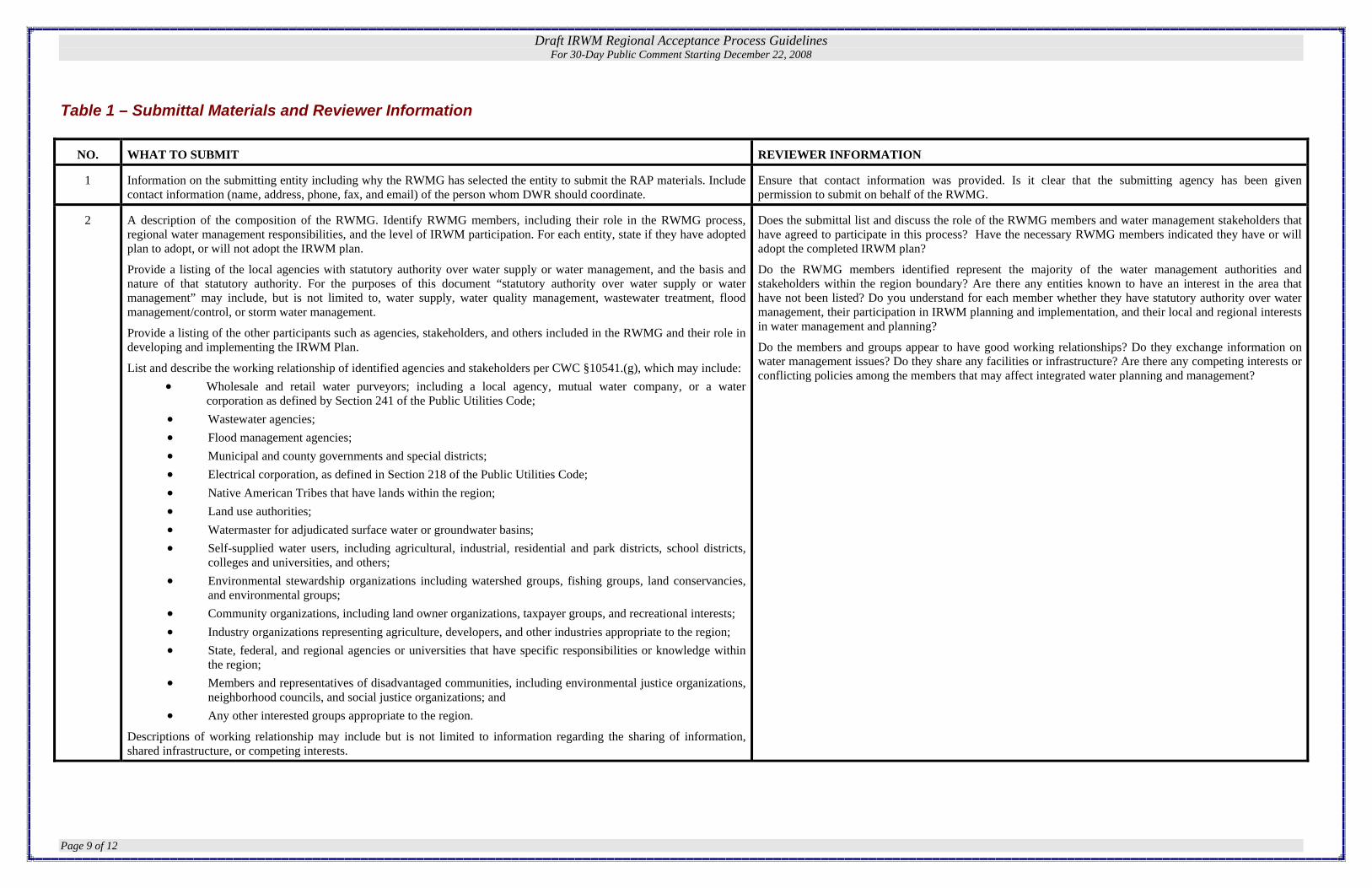
Table 1 – Submittal Materials and Reviewer Information
NO. WHAT TO SUBMIT REVIEWER INFORMATION
1 Information on the submitting entity including why the RWMG has selected the entity to submit the RAP materials. Include contact information (name, address, phone, fax, and email) of the person whom DWR should coordinate.
Ensure that contact information was provided. Is it clear that the submitting agency has been given permission to submit on behalf of the RWMG.
2 A description of the composition of the RWMG. Identify RWMG members, including their role in the RWMG process, regional water management responsibilities, and the level of IRWM participation. For each entity, state if they have adopted plan to adopt, or will not adopt the IRWM plan.
Provide a listing of the local agencies with statutory authority over water supply or water management, and the basis and nature of that statutory authority. For the purposes of this document “statutory authority over water supply or water management” may include, but is not limited to, water supply, water quality management, wastewater treatment, flood management/control, or storm water management.
Provide a listing of the other participants such as agencies, stakeholders, and others included in the RWMG and their role in developing and implementing the IRWM Plan.
List and describe the working relationship of identified agencies and stakeholders per CWC §10541.(g), which may include: • Wholesale and retail water purveyors; including a local agency, mutual water company, or a water
corporation as defined by Section 241 of the Public Utilities Code; • Wastewater agencies; • Flood management agencies; • Municipal and county governments and special districts; • Electrical corporation, as defined in Section 218 of the Public Utilities Code; • Native American Tribes that have lands within the region; • Land use authorities; • Watermaster for adjudicated surface water or groundwater basins; • Self-supplied water users, including agricultural, industrial, residential and park districts, school districts,
colleges and universities, and others; • Environmental stewardship organizations including watershed groups, fishing groups, land conservancies,
and environmental groups; • Community organizations, including land owner organizations, taxpayer groups, and recreational interests; • Industry organizations representing agriculture, developers, and other industries appropriate to the region; • State, federal, and regional agencies or universities that have specific responsibilities or knowledge within
the region; • Members and representatives of disadvantaged communities, including environmental justice organizations,
neighborhood councils, and social justice organizations; and • Any other interested groups appropriate to the region.
Descriptions of working relationship may include but is not limited to information regarding the sharing of information, shared infrastructure, or competing interests.
Does the submittal list and discuss the role of the RWMG members and water management stakeholders that have agreed to participate in this process? Have the necessary RWMG members indicated they have or will adopt the completed IRWM plan?
Do the RWMG members identified represent the majority of the water management authorities and stakeholders within the region boundary? Are there any entities known to have an interest in the area that have not been listed? Do you understand for each member whether they have statutory authority over water management, their participation in IRWM planning and implementation, and their local and regional interests in water management and planning?
Do the members and groups appear to have good working relationships? Do they exchange information on water management issues? Do they share any facilities or infrastructure? Are there any competing interests or conflicting policies among the members that may affect integrated water planning and management?

Draft IRWM Regional Acceptance Process Guidelines For 30-Day Public Comment Starting December 22, 2008
Page 10 of 12
3 A description of how stakeholders, including DACs, are identified and invited to participate. List the procedures, processes, or structures that promote access to and collaboration with people or agencies with diverse views within the region. Discuss how the outreach efforts address the diversity of water management issues, geographical representation, and stakeholder interests in the region. Explain how the IRWM region is inclusive and utilizes a collaborative, multi-stakeholder process that provides mechanisms to assist DAC; address water management issues; and develop integrated, multi-benefit, regional solutions that incorporate environmental stewardship to implement future IRWM plans.
Does the list of stakeholders appear to be inclusive? Are DACs given an opportunity to participate? Does it appear that the RWMG includes stakeholders, including DACs, in its planning process and implementation?
Do stakeholder outreach efforts promote participation of broad-based water planning and management interests in the region? Do the listed stakeholders provide a balanced representation of the water issues in the region?
Does the submittal describe how stakeholders, including DACs, are identified and invited to participate? Are the procedures, processes, or structures that promote access to and collaboration with people or agencies with diverse views within the region listed and discussed?
Does it appear that the IRWM region is inclusive and utilizes a collaborative, multi-stakeholder process that provides mechanisms to assist DAC and address water management issues? Will this result in the development of integrated, multi-benefit, regional solutions that incorporate environmental stewardship to implement the IRWM plan?
4 A description of the process being used that makes the public both part of and aware of the regional management and IRWM efforts. Discuss ways for the public to gain access to the RWMG and IRWM process for information and provide input.
Does the RWMG allow the public to participate in regular meetings? Is there an established method of posting meeting agendas, notices, and minutes? Are they posted with sufficient lead time for the public to participate in meetings?
Is it clear who the public should contact within the RWMG if they have questions regarding regional water management efforts or IRWM planning and implementation in the region? Are there public meetings held to solicit public comments ahead of major decisions to be made by the RWMG? What is the process for the public to provide input to RWMG on regional water management and/or IRWMP? And what is the process being used by the RWMG to evaluate and respond to that input?
5 A description of the RWMG governance structure and how it will facilitate the sustained development of regional water management and the IRWM process, both now and beyond the state grant IRWM funding programs.
Discuss how decisions are made. Identify the steps in which RWMG arrives at decisions and how RWMG members participate in the decision-making process. Examples of RWMG decisions to consider in discussion:
• Establishing IRWM plan goals and objectives
• Prioritizing projects
• Financing RWMG and IRWMP activities
• Implementing plan activities
• Making future revisions to the IRWM plan
• Hiring & managing consultants
Describe how the RWMG will incorporate new members into the governance structure. Explain the manner in which a balance of interested persons or entities representing different sectors and interests have been or will be engaged in the process, regardless of their ability to contribute financially to the plan.
Describe how the governance structure facilitates development of a single collaborative water management portfolio, prioritized on the regional goals and objectives of the IRWM region.
Are the roles and responsibilities of the RWMG clearly supportive of regional planning?
Does the RWMG operate in a collaborative manner? Is it clear how decisions are made, including establishing plan goals and objectives, prioritizing projects, financing RWMG activities, implementing plan activities, and making future revisions to the IRWM plan?
Who participates in the decision making process? Are all of the RWMG members involved or are there designated committees? Does the governance structure allow only certain members to vote on decisions? Does the decision making process allow for the participation of stakeholders and smaller entities? Do members have to contribute financially to the RWMG to be allowed to vote?
Can the RWMG governance structure facilitate the sustained development of the IRWM region now and beyond the current IRWM funding programs? Does the group require members to contribute to the group’s expenses, and if not, how will the group identify a budget for its operations, such as plan updates.
Will the governance structure facilitates development of a single collaborative water management portfolio, prioritized on the regional goals and objectives of the IRWM region?

Draft IRWM Regional Acceptance Process Guidelines For 30-Day Public Comment Starting December 22, 2008
Page 11 of 12
6 Present the IRWM regional boundary. Indicate in the submittal which boundaries are included and if/how they affect the determination of the region boundary:
• Political/jurisdictional boundaries; • Water, conservation, irrigation, and flood district boundaries; • Watershed management areas; • Groundwater basins as defined in DWR Bulletin 118, Update 2003 – California’s Groundwater; • RWQCB boundaries • Floodplain maps (i.e. FEMA/Corps of Engineers); • Physical, topographical, geographical and biological features; • Surface water bodies; • Major water related infrastructure; • Impaired water bodies; • Population; • Biological significant units or other biological features (critical habitat areas); and • Disadvantaged communities with median household income demographics
Explain how the IRWM region encompasses the service areas of multiple local agencies and will maximize opportunities to integrate water management activities related to natural and man-made water systems, including water supply reliability, water quality, environmental stewardship, and flood management.
On a CD, provide map(s) that present the regional boundaries in UTM Zone 10, NAD 27 format, including the above information, if applicable.
Does it appear that the IRWM region boundary was based solely on political boundaries?
Is it clear what is the basis and rationale for the IRWM region boundary? Does it make sense for long term water management?
Does the IRWM region boundary consider multiple water management boundaries such as watershed and groundwater basins?
Does the region boundary appear appropriate given the context of the region’s unique water management issues?
Does the IRWM region encompass the service areas of multiple local agencies? Does it appear that the IRWM region is structured to maximize opportunities to integrate water management activities related to natural and man-made water systems, including water supply reliability, water quality, environmental stewardship, and flood management?
7 A description of the history of IRWM efforts in the region. Describe how the region boundary relates to the current water resources and historic water management issues in the region?
A description of the regional water management issues, and conflicts in the region. Issues and conflicts may relate to water supply, water quality, flood management, environmental stewardship, imported water, waste water, conjunctive use, etc. Also describe efforts to develop multi-benefit integrated programs and projects that meet regional priorities.
A description of the water related components of the region. The submittal must consider two different types of components, the physical components and the groups that manage or have input to those components. Physical components of a water system include natural and man made infrastructure. Some of the components we expect to see include are watersheds, surface water impoundments, ground water basins, water collection systems, distribution systems, wastewater systems, flood water systems, and recharge facilities. The submittal should explain how water arrives in the region, how it is used, and how it is handled after it is used.
Is it clear how the history of water management in the region affects the boundaries that exist in the region and how it shapes the water management issues facing the region today?
How has water conflict been resolved in the region? Have there been established water management groups that collaborated to resolve these differences? Is the RWMG associated with these groups?
Does the submittal provide a comprehensive understanding of the water resources available to the region and provide context to the region’s water management challenges today and into the future?
Does it appear that multi-benefit, integrated, programs and projects will be developed to meet regional priorities?
Are the extent and conditions of the water infrastructure in the region well understood? Is it clear where the critical components of the water system reside and the parties responsible to manage and maintain them historically? When were they put into service and are there capital improvement plans to repair or replace them in the near future?
Does the described system omit any obvious water-related components such as watersheds, surface water impoundments, ground water basins, water collection systems, distribution systems wastewater systems, flood water systems, or recharge facilities?

Draft IRWM Regional Acceptance Process Guidelines For 30-Day Public Comment Starting December 22, 2008
Page 12 of 12
8 A description of the IRWM region’s relationship and coordination with adjacent existing or developing IRWM regions.
Identify any overlapping areas and explain the basis for the overlap. Discuss whether there is a clear relationship and acknowledgement by both regions that the overlap is acceptable.
Explain whether the regional boundary will leave any uncovered or void areas immediately outside or within the boundary.
Describe any areas within the region that are excluded or create a void area and explain why this is reasonable and appropriate.
Are there distinct water management differences between adjacent or overlapping IRWM regions and the proposed IRWM region to support being separate IRWM regions?
It is important to note that not only do the region boundaries need to make sense from hydrological, water system, and water issue perspectives; but we also need to consider a broader view of how all the IRWM boundaries fit together to achieve benefits statewide. Consider the shape of the IRWM; and how it relates to other regions nearby.
Determine if the RWMG has successfully managed overlaps or gaps within and outside of the region boundary. If there are overlapping IRWM regions, is there a clearly defined relationship between the IRWM planning regions? Are there indications the overlapping regions have discussed their water management issues and coordinated on activities occurring in overlapping areas?
Is there sound reasoning for having more than one RWMG planning water management issues for the same area? Are there distinct water management differences between adjacent or overlapping IRWM regions and the proposed IRWM region to support being separate IRWM regions?
Does the submittal describe any areas within the region that are excluded or create a void area and explain why this is reasonable and appropriate? Has the boundary been drawn so that the region leaves uncovered or void areas within the region or immediately outside the boundary? Will the region boundary create a planning gap in the region? Are there overlaps, gaps, or holes in the region coverage that do not seem to make sense?

Project Id Project Title Agency Project Description NOTES
10981
Emerald Necklace-Segment F: Whittier Narrrows to South of Pico Rivera Sprea Amigos de los RÃ-os
This Emerald Necklace multi benefit project involves landscaping, restoring and beautifying & adding a water quality to a critical 4 mile segment of land adjacent to the San Gabriel River from Whittier Narrrows to South of the Pico Rivera Spreading Ground. This area is 20 acres in total and will include habitat and multi benefit trails including a stabilized decomposed granite path, lighting, access gateways, way finding & interpretive signage, native vegetation & other recreation & exercise amenities. The project will function as part of the part of the Emerald Necklace regional park network to address local and regional water quality, water conservation, open space needs, habitat restoration, and public education. Treatments are based on creating an integrated network of environmentally sensitive and beneficial best management practices throughout the Emerald Necklace System.
9861
Emerald Necklace – Segment B: Eaton Wash to South Edge of Peck Park
Amigos de los RÃ-os/ City of El Monte/Emerald Necklace Coalition
This Emerald Necklace multi-benefit project involves landscaping, restoring and beautifying & adding a water quality and water conservation swale 7 miles of the LA County Flood Control District right of way along the Rio Hondo as it passes through El Monte in accordance with the LA River Landscaping Guidelines. This bioswale greening area is 13 acres in total and will include a community habitat park; multi benefit trails including a stabilized decomposed granite path, lighting, access gateways, way finding & interpretive signage, native vegetation & other recreation & exercise amenities. The project will function as part of the part of the Emerald Necklace regional park network to address local and regional water quality, water conservation, open space needs, habitat restoration, and public education. Treatments are based on creating an integrated network of environmentally sensitive and beneficial best management practices throughout the Emerald Necklace System.
9833
Emerald Necklace – Segment A: Alhambra Wash to Eaton Wash
Amigos de los RÃ-os/City of El Monte/Emerald Necklace Coalition
This Emerald Necklace multi benefit project involves landscaping, restoring, beautifying and adding a water quality and water conservation swale 2.7 miles of Army Corp of Engineer and LA County Flood Control District right-of-way along the Rio Hondo as it passes through El Monte and Baldwin Park. This bioswale greening area is 80 acres in total and will include a community habitat park; multi-benefit trails including a stabilized decomposed granite path, lighting, access gateways, way-finding & interpretive signage, native vegetation & other recreation & exercise amenities. The project will function as portion of the Emerald Necklace regional park network to address local and regional water quality, water conservation, open space needs, habitat restoration, and public education. Treatments are based on creating an integrated network of environmentally sensitive and beneficial best management practices throughout the Emerald Necklace System.

Project Id Project Title Agency Project Description NOTES
9869
Emerald Necklace – SEGMENT D: San Gabriel River in El Monte to Azusa
Amigos de los RÃ-os/City of El Monte/Emerald Necklace Coalition
This Emerald Necklace multi benefit project involves landscaping, restoring, beautifying & adding a water quality and water conservation swale to a critical 2.9 mile segment of land adjacent to the SGR banks from the boundary of El Monte to Azusa. This segment begins where Hanson Aggregates trail meets the SGR in the south & extends north to Angeles Forest in Azusa. This bioswale greening area is 12 acres in total & will include a community habitat park; multi benefit trails of stabilized decomposed granite, lighting, access gateways, way finding & interpretive signage, native vegetation & other recreation & exercise amenities. The project will function as part of the part of the Emerald Necklace Regional Park network to address local & regional water quality, water conservation, open space needs, habitat restoration, and public education. Treatments are based on creating an integrated network of environmentally sensitive and beneficial best management practices throughout the Emerald Necklace System.
9865
Emerald Necklace-Segment C: Peck Road Water Conservation Park-San Gabriel R
Amigos de los RÃ-os/City of El Monte/Emerald Necklace Coalition
This Emerald Necklace multi-benefit project involves landscaping, restoring and beautifying & adding a water quality and water conservation swale to a critical 1.7 mile segment of land adjacent to the South edge of the Hanson Quarry linking the RH & SGR. This segment continues down the SGR to Ramona Boulevard. This bioswale greening area is 6 acres in total and will include a community habitat park; multi benefit trails including a stabilized decomposed granite path, lighting, access gateways, way finding & interpretive signage, native vegetation & other recreation & exercise amenities. The project will function as part of the part of the Emerald Necklace regional park network to address local and regional water quality, water conservation, open space needs, habitat restoration, and public education. Treatments are based on creating an integrated network of environmentally sensitive and beneficial best management practices throughout the Emerald Necklace System
10965
Emerald Necklace-Segment E: Ramona Blvd to Whittier Narrows
Amigos de los RÃ-os/Emerald Necklace Coalition
This Emerald Necklace multi benefit project includes landscaping, restoring and beautifying & adding a water quality to a critical 4 mile segment of land adjacent to the San Gabriel River and reaching from Ramona Blvd. to Whittier Narrows. This segment of greening area is 20 acres in total and will include a community habitat park; multi benefit trails including a stabilized decomposed granite path, lighting, access gateways, way finding & interpretive signage, native vegetation & other recreation & exercise amenities. The project will function as part of the part of the Emerald Necklace regional park network to address local and regional water quality, water conservation, open space needs, habitat restoration, and public education. Treatments are based on creating an integrated network of environmentally sensitive and beneficial best management practices throughout the Emerald Necklace System

Project Id Project Title Agency Project Description NOTES
11117
Arcadia Wash Naturalization Design Development & Construction Plans Amigos de los Rios
Design Development and Construction drawings to naturalize parts of the channel that passes through the LA County Arboretum, Santa Anita Park and Golf Course. Other features in the 22-acre area include native landscaping, a trail, benches, educational signage, bridges, and other amenities. The naturalized section will be designed using hydraulic modeling for optimal functioning during flood events. Overall the project will function as part of the part of the Emerald Necklace/adjacent washes system to address local and regional water quality, water conservation, open space needs, habitat restoration, and public education. Various site-specific treatments are based on creating an integrated network of environmentally sensitive and beneficial best management practices throughout the Emerald Necklace system. These include extensive phytoremediation, use of cisterns for capture and recycling, and at the Arboreteum, use of detention basins.
10866Gibson Mariposa Multi-Benefit Park Amigos de los Rios
Gibson "Mariposa" Park design consists of a large grass play field, playground area for 3 different age appropriate zones, two half-basketball courts, splashpad, several picnic/barbeque areas, parking lot, restrooms, outdoor classroom/amphitheater, interpretive signage (history of the adjacent railroad, Rio Hondo River, and local ecology)native habitat areas, educational kiosk and weather station, butterfly vivarium and a walking and jogging path. The involvement of residents in the planning process has been a wonderful catalyst in fostering community pride and civic involvement and will help ensure the long-term sustainability of the site. The design of the park will facilitate additional learning opportunities in earth science, history, and teamwork. This Park will also be a resource for nearby Rio Vista Elementary and Gidley Elementary/Middle Schools.
10788Green Collar Youth Training Program Amigos de los Rios
Amigos will provide two 2 month courses called the Youth Green Collar Training Project to offer training in environmental services for 50 at-risk youth ages 16 â €“ 24 in order to initiate workforce development for the Emerald Necklace. The under 25 population in this region totals 119,840, nearly 45% of the population, many of whom are considered “at-riskâ€� because of poverty, unemployment, delinquency, teen pregnancy, and exposure to drugs and gangs. As many as 100 youth will be recruited from the cities of El Monte, South El Monte, Baldwin Park, Irwindale, Rosemead, and East Los Angeles through collaborations with local youth service organizations, local school districts, and our affiliates in the workforce development sector, the Central San Gabriel Valley WorkSource or Career Partners (One-Stop). Recruits will be given an assessment evaluation that will be used to identify 50 participants with the necessary interest level while also determining their basic skill level.

Project Id Project Title Agency Project Description NOTES
840
Peck Water Conservation Park - Design Development & Construction Plans Amigos de los Rios
Complete update of outreach, scoping & design development/construction drawings for Peck Park to maximize benefits of this facility. Planned improvements to park include reclaimed water irrigation system, improved parking lot and BMP swale, 40 acres of habitat restoration, 2 miles of multi use trail creation or enhancement including lookout vistas & amenities (bike, equestrian, pedestrian, floodable trail bridge), & 25 acres of recreational space enhancement, educational interpretive signage. Trails are critical connections to regional trail resources, critical segment of the Emerald Necklace. The Park also includes an 80 Acre Lake which is host to myriad birds and aquatic species–303 species have been counted. There are approximately 35-40 acres of potential habitat restoration areas around the perimeter of the lake in excess of the maintenance road areas required by the Flood Division that need to be revegetated to support habitat, open space restoration. Compatible with County Flood plans for zone.
837
Peck Water Conservation Park Implementation Amigos de los Rios
Planned Improvements to Park include a reclaimed water irrigation system, improved parking lot and BMP swale, 40 acres of habitat restoration, 2 miles of multi-use trail creation or enhancement including lookout vistas & amenities ( bike, equestrian, pedestrian, floodable trail bridge), & 25 acres of recreational space enhancement, educational interpretive signage. Trails are critical connections to regional trail resources, and a critical segment of the Emerald Necklace. The Park also includes an 80 acre lake which is host to 303 myriad birds and aquatic species that have been counted. There are approximately 35 to 40 acres of potential habitat restoration areas around the perimeter of the lake in excess of the maintenance road areas required by the Flood Division) that need to be revegetated to support habitat and open space restoration. Compatible with County Flood plans for zone.
10832
San Gabriel River Discovery Center Overlook Amigos de los Rios
The Overlook project will serve as a key educational focal point for the natural and managed water processes in the area. Its proposed location lies directly on both the San Gabriel River and Lario Creek, and, with its strong links to near and distant open space amenities, the Overlook will allow a closer, more meaningful experience of the San Gabriel River while attracting large numbers of school children to view and learn about this important watershed landscape. As a project related to the overall scheme for the Discovery Center, the Overlook will provide a pivotal connection point for the recreational opportunities of the Center and the bike trail. It will serve an outdoor classroom suitable for complimenting the program of the indoor interpretive center and natural and cultural trails.
641
Arcadia Wash Naturalization Project
Amigos de los Rios/Rivers and Mountains Conservancy
Construction to naturalize parts of the channel that pass through the LA County Arboretum, Santa Anita Park and Golf Course. Other features in the 22-acre area include native landscaping, a trail, benches, educational signage, bridges, and other amenities. The naturalized section will be designed using hydraulic modeling for optimal functioning during flood events. Overall, the project will function as portion of the Emerald Necklace/adjacent washes systems to address local and regional water quality, water conservation, open space needs, habitat restoration, and public education. Various site-specific treatments are based on creating an integrated network of environmentally sensitive and beneficial best management practices throughout the Emerald Necklace system. These include extensive phytoremediation, use of cisterns for capture and recycling, and at the Arboreteum, use of detention basins.
Project Id Project Title Agency Project Description NOTES
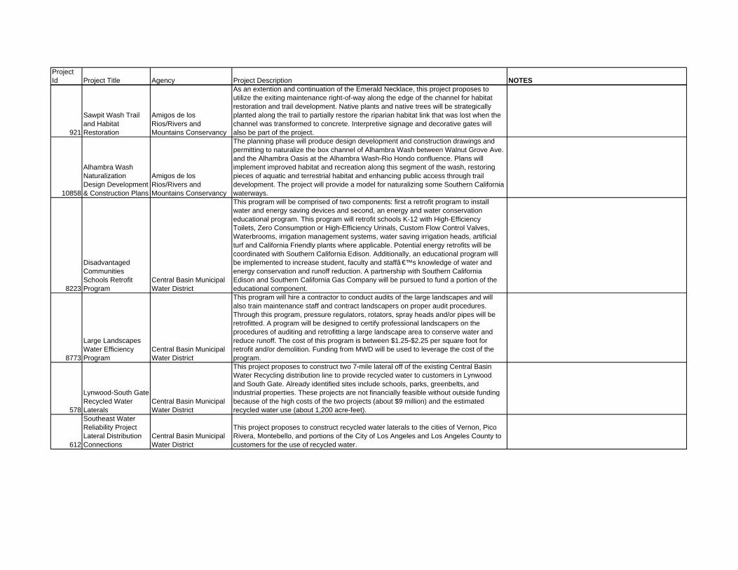
921
Sawpit Wash Trail and Habitat Restoration
Amigos de los Rios/Rivers and Mountains Conservancy
As an extention and continuation of the Emerald Necklace, this project proposes to utilize the exiting maintenance right-of-way along the edge of the channel for habitat restoration and trail development. Native plants and native trees will be strategically planted along the trail to partially restore the riparian habitat link that was lost when the channel was transformed to concrete. Interpretive signage and decorative gates will also be part of the project.
10858
Alhambra Wash Naturalization Design Development & Construction Plans
Amigos de los Rios/Rivers and Mountains Conservancy
The planning phase will produce design development and construction drawings and permitting to naturalize the box channel of Alhambra Wash between Walnut Grove Ave. and the Alhambra Oasis at the Alhambra Wash-Rio Hondo confluence. Plans will implement improved habitat and recreation along this segment of the wash, restoring pieces of aquatic and terrestrial habitat and enhancing public access through trail development. The project will provide a model for naturalizing some Southern California waterways.
8223
Disadvantaged Communities Schools Retrofit Program
Central Basin Municipal Water District
This program will be comprised of two components: first a retrofit program to install water and energy saving devices and second, an energy and water conservation educational program. This program will retrofit schools K-12 with High-Efficiency Toilets, Zero Consumption or High-Efficiency Urinals, Custom Flow Control Valves, Waterbrooms, irrigation management systems, water saving irrigation heads, artificial turf and California Friendly plants where applicable. Potential energy retrofits will be coordinated with Southern California Edison. Additionally, an educational program will be implemented to increase student, faculty and staffâ €™s knowledge of water and energy conservation and runoff reduction. A partnership with Southern California Edison and Southern California Gas Company will be pursued to fund a portion of the educational component.
8773
Large Landscapes Water Efficiency Program
Central Basin Municipal Water District
This program will hire a contractor to conduct audits of the large landscapes and will also train maintenance staff and contract landscapers on proper audit procedures. Through this program, pressure regulators, rotators, spray heads and/or pipes will be retrofitted. A program will be designed to certify professional landscapers on the procedures of auditing and retrofitting a large landscape area to conserve water and reduce runoff. The cost of this program is between $1.25-$2.25 per square foot for retrofit and/or demolition. Funding from MWD will be used to leverage the cost of the program.
578
Lynwood-South Gate Recycled Water Laterals
Central Basin Municipal Water District
This project proposes to construct two 7-mile lateral off of the existing Central Basin Water Recycling distribution line to provide recycled water to customers in Lynwood and South Gate. Already identified sites include schools, parks, greenbelts, and industrial properties. These projects are not financially feasible without outside funding because of the high costs of the two projects (about $9 million) and the estimated recycled water use (about 1,200 acre-feet).
612
Southeast Water Reliability Project Lateral Distribution Connections
Central Basin Municipal Water District
This project proposes to construct recycled water laterals to the cities of Vernon, Pico Rivera, Montebello, and portions of the City of Los Angeles and Los Angeles County to customers for the use of recycled water.

Project Id Project Title Agency Project Description NOTES
8305
Urban City Makeover for Disadvantaged Communities
Central Basin Municipal Water District
Central Basin will institute a City Makeover Program with nine specific cities in its service area. This Urban City Makeover program will renovate specific city-owned facilities with new, water-saving devices and low water use materials to provide a direct water savings for the communities. Facilities include public restrooms, parks and other city facilities. Specifically, the program will concentrate on 1) replacing existing conventional toilets (3.5 gallons per flush) with High Efficiency Toilets (HETs) that use less than 1.3 gallons per flush, 2) replacing conventional urinals with waterless urinals, 3) replacing conventional turf and landscape with California native plants (California Friendly Plants), 4) Artificial Turf, 5) installing Weather-based Irrigation Controllers (WBICs) for landscaping areas 6) providing Waterbrooms to city Operations and Maintenance staff to reduce water consumption and runoff during cleaning activities and 7) Custom Flow Control Valves in areas without faucet aerators.
8396
High-Efficiency Toilet Program for Disadvantaged CII and Residential
Central Basin Municipal Water District
Central Basin will directly install HETs for low-income single- and multi-family households and business. MWD will provide an incentive of $165 per HET to offset cost of the direct install. The total cost of the toilet and installation varies from locations and types of HETs needed. For simplification purposes, the direct-installs will be dived into three groups: 1) Residential including multi-family, 2) Commercial and 3) High-Vandalism Commercial. High-Vandalism commercial areas such as public parks currently have stainless steel toilets and would need to be replaced with stainless steel HETs.
1073
Industrial Process Audits and Incentives Program
Central Basin Municipal Water District
Central Basin’s existing Industrial Process Program targets industrial customers in four segments: textiles, food processing, metal plating, and electronics. The program provides audits and recommendations to customers to improve the water efficiency of their processes. Upon verification of water savings, Central Basin, in partnership with the Metropolitan Water District of Southern California (MWD), provides rebates to offset the cost of implementing the audit recommendations. These rebate is currently $3.00 per 1,000 gallons saved. To expand Central Basin’s Industrial Program, additional funding is needed to provide an additional $2.00 per 1,000 gallons saved and to hire a consultant. The consultant will deliver audits and recommendation to additional industrial customer segments. A partnership with Southern California Edison (SCE) will be sought to have account representatives in the Business Customer Division identify additional interested customers.
1101
Small System Infrustructure Rehabilitation Program
Central Basin Municipal Water District
In concept, state funding for this program will be retained by Central Basin MWD and used to fund critical need infrustructure repair and/or rehabilitation as needed in small water systems that are in economically disadvataged areas. Central Basin MWD staff have already requested capital project needs assessments from the small system managers. Projects will focus on the repair or replacement of existing infrustructure. Projects could include mainline replacement, valve repair/replacement, wellhead upgrades, pump repair/replacement, storage tank repair/replacement, meter upgrades, etc. With these upgrades, water quality, reliability and leak reduction should improve significantly.
1147Southeast Water Reliability Project Central Basin MWD
System expansion that will loop the Rio Hondo (Torres) and Century (Ibbetson) systems for flow reliability.

Project Id Project Title Agency Project Description NOTES
600Bellflower Riverview Park City of Bellflower
Development of a 15.5-acre regional, low impact recreation area adjacent to the San Gabriel River. Proposed improvements include a paved bikeway, trees, drought tolerant native plants, landscaping, irrigation, dry creek bed to treat stormwater runoff, park benches and informational signage. The project area is located within the Edison right-of-way (11.4 acres) and City property (3.9 acres) between Somerset Boulevard and Alondra Boulevard.
519
Bellflower Water System Improvement Program City of Bellflower
The city of Bellflower has completed its Water System Improvement Program (WSIP) for its recently purchased water system. The WSIP, as a component of the Bellflower Municipal Water System 2008 Master Plan, has identified several key capital projects needed to enhance the integrity of the system, reduce imported water reliance, and improve water quality. Cornerstone of the WSIP is the construction of a high-capacity well. This new well will be built on existing city-owned proeprty and connect to the existing distribution system. That system also has inter-ties to other local companies which could also be served. The project will function as a municipal PW project governed by the laws of this State and the conditions of the funding source. A design engineer will prepare biddable documents. A construction engineering firm will be hired to oversee construction. Groundwater produced by the well will be treated as necessary to adhere to State water quality requirements.
584NPDES Permit Compliance City of Bellflower
Implement strategies like structural controls, hard construction, monitoring and education to meet TMDL objectives and receiving water limitations thereof.
585
NPDES Permit/TMDL Special Studies City of Bellflower To complete special studies required by TMDLs for the San Gabriel River watershed.
603Sanitary Sewer Replacement MP City of Bellflower
The City of Bellflower (City) has 95 miles of sewer pipes. Much of the system was constructed around or before the City's incorporation in 1957. The City's recently completed Sewer Master Plan determined capacity issues and created a plan to closed circuit TV the entire length of the system for structural deficiences. That program is scheduled over the next 3 years. The City is required by the State Resources Boar's SSO WDR to prioritize deficiencies into 3 categories and establish a capital improvement plan to repair/replace all deficiences. The Master Plan determined that 6.5% (more than 6 miles) of the system lines do meet capacity. Engineer's estimate to increase capacity is between $10,000,000-$13,000,000. It is anticipated that initial line repair/replacement for structural deficiences will double this figure. Each project to improve a reach of sewer will be conducted as a PW capital project adhering to State law. Design engineering costs is also anticipated for some projects.
161
Compton Creek Equestrian Trail, Phase I City of Comption
Project will be located on the W. side of the Compton Creek within the City of Compton. Water quality concerns (bacteria) will be addressed by proper trail construction and maintenance practices.
164
Edison Transmission Corridor Multi-Use Trail City of Compton
Transmission corridor running from Hemingway Park in Carson, through Compton on Greenleaf Boulevard, crossing the Compton Creek, and ultimately running to the LA River.
189
Gonzales Park Addition, Pedestrian Bridge, & Mural City of Compton
Located at the future Horse Trail along the West Bank of the Compton Creek, this under-utilized corner of the existing Gonzales Park will be converted to a neighborhood that was previously cut off from the park

Project Id Project Title Agency Project Description NOTES
204Cudahy River Drive Beautification City of Cudahy
The project involves developing river front park(s) along River Drive Road, engaging and educating residents living in Cudahy about stormwater issues through a community mural, and providing a stormwater filtration system to help improve water quality in the County of Los Angeles River.
682Clear Creek Canyon Dr. OS
City of Diamond Bar, RMC
Acquisition of 3 acres of open space under threat of residential development. Once the land is aquired designs will be made for habitat restoration and a rest area along the urban walkway. There will be a bench and a trash receptacle so residents and hikers may rest after walking the urban walkway or Steep Canyon Trail. Habitat restortation on rest of the property will help the flora and fauna to florish in the middle of this urban community, saving open space for all time. As part of the SUSMP the City of Diamond Bar will evaluate and/or implememt a low impact and infiltration design.
528
City of Downey Groundwater Treatment Plant Project City of Downey
Construct 25 MGD groundwater treatment plant at City-owned maintenance yard site. Need for treatment plant identified in City's 2003 Groundwater Master Plan.
529
City of Downey Groundwater Well Supply Reliability Project City of Downey
Design and construction of three 3,000 gpm deep aquifer groundwater wells and associated pipelines and appurtenances. New wells will replace old shallow wells that are susceptible to future surface and shallow aquifer contamination.
547
Dennis The Menace Park Storm Drain Detention/Infiltration Project City of Downey
Design and construction of a storm drain and detention/infiltration system to capture, treat, and store stormwater runoff within Central Groundwater Basin Aquifers.
554
Furman Park Storm Drain Detention/Infiltration Project City of Downey
Design and construction of a storm drain and detention/infiltration system to alleviate flooding from under capacity trunk lines, and capture, treat, and store stormwater runoff within Central Groundwater Basin Aquifers.
555
Furman Park/Rio Hondo Elementary School Reclaimed Water Main Extension and City of Downey
Design and construction of reclaimed water irrigation improvements at Furman Park and extension of a reclaimed water main and associated facilities along Quinn St. from Rio Hondo Golf Course east to Furman Park and Rio Hondo Elementary School.
569
Lakewood Boulevard and Florence Avenue Reclaimed Water Improvement Project City of Downey
Design and extension of a reclaimed water main and associated facilities along Lakewood Boulevard from Fifth St. north to Telegraph Rd. and from the San Gabriel River west to Lakewood Blvd.
1991
West San Gabriel River Parkway Nature Trail -- Phase III City of Lakewood
This project will include the development of 10.7 acres of land adjoing the west bank of the San Gabriel River--extending a current one-mile riparian development an additional half-mile. The plan include a connective path linking to area recreational trails and venues along the river with the planting of (a majority) meadow grasses, shrubs and trees.

Project Id Project Title Agency Project Description NOTES
1274Colorado Lagoon Restoration Project
City of Long Beach, Department of Parks, Recreation and Marine
The project will restore the lagoon water quality by removing the accumulated chemical pollutants in bottom sediments through dredging, reducing the inflow of pollutants by diverting the non-storm urban run-off from two major storm drain lines to the sanitary sewer system, developing bioswales to filter the minor lines before discharge, tracing pollution sources and monitoring water quality. It will also restore tidal flushing by cleaning the existing culvert and creating an open connecting channel between the lagoon and Alamitos Bay. The project will also restore habitat values by resloping vertical edges to sloping intertidal habitat zones and replacing ornamental plants with natives. Finally, the project will reduce flooding by diverting approximately 40 percent of the storm flows discharge to the larger Alamitos Bay.
4534
DeForest Basin Wetlands Restoration
City of Long Beach, Department of Parks, Recreation and Marine
The project will restore natural wetland habitat functions from existing non-storm and storm runoff and improve public access trails and wildlife appreciation opportunities. This will be done by regrading the basin so that the non-strom runoff will continue to flow through the basin until complete absorbtion or discharge into the Los Angeles River at an existing pump station. Exotic plants will be removed and the area replanted with native plants in open water, deep marsh, shallow marsh, seasonal mudflat, low riparian, high riparian and native scrub habitats. Recreational access will be improved with trails, floating platforms, landscape viewing screens, observation platforms and interpretative signage. Natural wetland processes will cleanse the non-storm flows prior to discharge.
1726
El Dorado Park Stream Restoration and Treatment Wetland
City of Long Beach, Parks, Recreation and Marine Department
The project will daylight an existing buried storm drain running through El Dorado Regional Park. Drainage from the adjacent shopping center will flow through a created stream channel into a wetland created adjacent to the river. An existing concrete culvert that drains the 605 freeway will also be rerouted to the treatment wetland. Treated water from the wetland will be discharged into the San Gabriel River.
1727
El Dorado Park Wetland Habitat Restoration
City of Long Beach, Parks, Recreation and Marine Department
Restore a wetlands habitat in a seven-acre storm water detention basin and a 15-acre utility corridor. Part of the site would be a treatment wetland to improve water quality for run-off from the park and adjacent shopping center and freeway.
1638Los Cerritos Wetland Acquisition
City of Long Beach, Parks, Recreation and Marine Department
Acquire the Bixby Ranch Co. portion of the Los Cerritos Wetland. This is the largest remaining privately owned wetland property in the San Gabriel River Estuary.
1732Porous Park Parking Lots
City of Long Beach, Parks, Recreation and Marine Department
There are 4,700 paved parking spaces in parks in Long Beach covering 43 acres of land. There are also seven miles of park roads covering 25 acres of land. This project is to replace those 68 acres of impervious pavement with porous concrete paving.

Project Id Project Title Agency Project Description NOTES
1722West San Gabriel River Parkway
City of Long Beach, Parks, Recreation and Marine Department
The West San Gabriel River Parkway project includes the restoration of 21 acres of grassland habitat on the west bank of the San Gabriel River. The restoration will involve the replacement of degraded and non-native vegetation between Spring Street and Atherton Street and includes a walking trail to allow for passive recreational use of the restored habitat. The proposed habitat restoration will include site preparation and soil treatment; removal of non-native, exotic, and invasive vegetation; planting of several species of native trees, shrubs, and grasses; and installation of an irrigation system to be used for plant establishment and during periods of severe drought. An annual vegetation monitoring and maintenance plan will also be written and implemented to manage the site. In addition to the Parkway trail itself, the project includes three access trails from parking areas in the adjacent El Dorado Park.
4551El Dorado Regional Park Lakes
City of Long Beach/Parks, Recreation and Marine
The project would be to utilize reclaimed water from a Los Angeles County Sanitation District plan at the southern end of the park to supply some if its excess water to fill the lakes. The water would flow into the lakes continously and flow between the lakes through the dry stream bed, and discharge to Coyote Creek through an existing overflow channel. To avoid additional nutrient problems with the reclaimed water, a nano-filtration system would be added to the reclaimed treatment to reduce nutrient levels to those in the well water. Secondary benefits would include the removing ornmental planst and replanting the areas along the stream beds with native riparian vegetation. The concrete overflow channel would be replaced with a vegetated swale to clean the discharge water.
1336DeForest Basin Habitat Restoration
City of Long Beach; Coastal Conservancy; County of Los Angeles; RMC Implementation of DeForest Basin Habitat Restoration Plan
7582Catch Basin Cover Phase III
City of Los Angeles, Department of Public Work
This project proposes the installation of CB opening screen covers in medium and low trash generation areas of the City. As trash is the primary target pollutant and will be either eliminated or significantly reduced by the installation of the CB covers. In addition, these CB covers will also reduce organic debris and sediment loading to the storm drain system. The CB opening screen covers are coarse screeens that are installed in the CB opening and prevent trash from entering the City storm drain system system. Each CB opening screen cover has a self-opening device activated by a presetermined street gutter flow to disengage its locking mechanis. These covers are designed to remian closed during both dry weather as well as small storms (
150Carnation and Rose Parks City of Lynwood
Potential stormwater treatment park space at State Street and Los Flores Boulevard in Lynwood. Opportunities to treat significant stormwater flow from South Gate and Lynwood exist within a multiple-benefit park space which could include storm-water supplied irrigation, active and passive recreation, habitat enhancement, stream daylighting, and educational features.

Project Id Project Title Agency Project Description NOTES
583
Norwalk Park Reservoir, Booster Pump Station & Well City of Norwalk
This program will provide for a key element in the City’s Water System Improvement Program comprised of the construction of a high capacity well, Reservoir & Booster Pump Station faculty located at the City’s Norwalk Park. The project will increase water supply capability and serve as a primary distribution point to move water to the City’s high and low pressure water systems, including areas located within the City of Artesia. This project has two phases, the first phase includes the construction of the water well, for which design has been completed. The Environmental documents are in the process of being approved by EPA. As soon as that is received, the bidding process for this project could be initiated. Phase II includes the 3.3 million gallon reservoir and pump station. Funding for that phase is still unavailable.
1014Arsenic Treatment for Zone 2 Well City of Santa Fe Springs
Provide Arsenic treatment facilities for Well No. 2. Water may benefit drinking water quality in Santa Fe Springs plus adjacent cities such as Norwalk and Cerritos. Arsenic treatment will be provided to meet new EPA MCL for drinking water.
581 New Well in Zone 1 City of Santa Fe Springs
Construct a new production well in zone 1 to supply potable water to Santa Fe Springs, parts of Norwalk, Downey and potentially Golden State Water Company. Design and construct well, piping, controls and all related equipment.
582 New Well in Zone 2 City of Santa Fe Springs Construction of new water well in zone 2 of the city.
590 Reclaimed Reservoir City of Santa Fe Springs Reclaimed Reservoir to provide added pressure to the reclaimed water system.
593Regional Water Treatment Facility City of Santa Fe Springs
Water treatment facility that would provide potable water by utilizing untreated state water, and the plant will have the technology to provide ground water clean up within the basin
1034
Cast Iron Main Replacement Program City of Santa Fe Springs NA
1110 New Well in Zone 1. City of Santa Fe Springs Construction of new water well in zone 1 of the City.
1111
New Zone 1 Reservoir/Pump Station City of Santa Fe Springs
Remove old natural gas and diesel internal combustion engines and replace them with electric driven motors and pumps to provide improved system psi. The project will also include a master controlling center with a variable frequency drive.
1112
New Zone 2 Reservoir/Pump Station City of Santa Fe Springs
Remove old natural gas and diesel internal combustion engines and replace them with electric driven motors and pumps to provide improved system psi. The project will also include a master controlling center with a variable frequency drive.
1119
Phase 1 Transmission Main Investigation, Repairs, and Design City of Santa Fe Springs NA
1120
Phase 2 Transmission Main Investigation, Repairs, and Design City of Santa Fe Springs NA
1124Portable generators for wells City of Santa Fe Springs NA

Project Id Project Title Agency Project Description NOTES
1131Recoating of Reservoir No 2 City of Santa Fe Springs Recoating interior of reservoir.
1132Recoating of Reservoir No. 1 City of Santa Fe Springs Recoating interior of reservoir.
1139
Reservoir No. 2 Chloramination Facilities City of Santa Fe Springs
Provide a water treatment facility at the Foster Road Reservior to chlorinate groundwater and treat purchased MWD water. The project includes the construction of an addition to the existing building to allow for bulk storage of chemicals. It also includes installation of chemical feed pumps, electrical panels, and all related piping.
1159
Undersized Main Replacement Program City of Santa Fe Springs Upgrade to 8 inch main (includes hydrant upgrade)
561
Hamilton Bowl Stormwater Quality Improvements City of Signal Hill
The project will construct modifications and/or devices in the Hamilton Bowl Detention Basin that will address various LA River TMDLs.
592Recycled Water System City of Signal Hill
The project will construct a recycled water system in the City of Signal Hill that could be expanded into areas of the City of Long Beach not currently served with recycled water. A concept system alignment has been established consisting of 3,000 feet of pipeline ranging in size from 4� to 12� in diameter. Potential irrigation and industrial recycled water users, such as Caltrans, have been identified. These users provide a total estimated recycled water demand of 404 acre-feet per year.
163 Confluence Park City of South Gate
Park is located on teh West Bank of the Rio Hondo approx 1 mile north of the confluence of the LA River and the Rio Hondo. Potential wetland habitat and water use efficiency benefits.
539Compton Creek Watershed Plan Coastal Conservancy
Implement Compton Creek Watershed Plan's proposed improvements that seeks to enhance a 2.8 mile (approximately 28 acres)of earthen-bottom section of existing Compton Creek stormwater channel. This rare urban resource is currently vegatated with nonnative invasive plants. Part of the project is to remove nonnative plants replant with appropriate native plants using the Los Angeles County Plant Pallet,and restricting rirppaian and wetland plants to those plants that can weather high energy rainwater/urban runoff flows, without diminishing the upgraded the stormwater capacity of the channel. The Channel capacity in this reach will be upgraded to current Los Angeles County standards.
187 Gage/AvalonTriangle
Community and Neighbors for Ninth District Unity
A new seating area has already been installed on site. The fully implemented project will include a playground, more seating, a grove of upland native trees, permeable DG surface, a storm water detention area, and a small, demonstration bio-swale.
544
Cressy Street/Washington ES CUSD NA
6720Graham Avenue Storm Drains Harbor Watts EDC
This project will convert Graham Avenue, which suffers from drainage problems near 103rd Street, into a green street. The drainage problems will be solved and a pedestrian linkage from the 103rd Street Blue Line Station will be made to the Watts Towers State Park.
6726Watts Creekside Bike Trail
Harbor/Watts Economic Development Corporation
Along the Compton Creek, north of the existing Bike Trail, from El Segundo Boulevard to Main and 108th. This trail would link open space, water quality BMPs, and pockets of habitat with a 2-mile multi-use trail.

Project Id Project Title Agency Project Description NOTES
6723Watts Gateway Phase II
Harbor/Watts Economic Development Corporation
Recently a project to build a gateway sign at the Imperial/Central intersection on the southern neighborhood boundary of Watts was completed on one corner. This project would expand the improvements to the three remaining corners of the same intersection. The Compton Creek Flows beneath this intersection.
6729 Watts Towers East
Harbor/Watts Economic Development Corporation
Just East of the Existing State Historic Park at Watts Towers, this vacant Parcel is a former rail corridor that can be added to the SHP and provide storm water quality benefits.
149South Los Angeles Wetlands Park LA City Council District 9
Located at Avalon and 53rd Street, Los Angeles, CA. The project will be located on a brownfield. This project will provide passive habitat and park space and will treat storm water from a contributing area greater than 30 square blocks of industrial/residential uses.
12143
Greenway Network of Willowbrook community
LA County Parks and Rec
Connecting Carver, Mona, Enterprise, and Magic Johnson Parks to encourage pedestrian activities as well as urban runoff treatment.
12139
Adventure Park: A Watershed Based Approach for Stormwater Control
LA County Parks and Recreation
The project include testing a model under development of the County of Los Angeles. The County of Los Angeles Flood Control Deparment is developing a Watershed Management Modeling System, a comprehensive decision support system to assit in selection of best management practices, definition of watershed planning objectives, and the development of strategic TMDL compliance plans. The project in the park will provide key data inputs to develop a watershed modeling system as a demontration project.
11924Ted Watkins Park Multibenefit Project
LA County Parks and Recreation
Creating bioswale stream course and detension basin to improve water quality and flood protection. Flows would be collected at Success and 92nd Street and travel about 4500 feet to the park for detention. The basin could be completely underground or a detention basin could be incorporated into the multiuse field for a much lower cost.
762
Invasive Plant Control in Riparian Habitat of Los Angeles Basin
LASGR Watershed Council
We will identify and map the populations of concern throughout Los Angeles County. Undesirable invasive non-native plants will be selectively controlled by targeted herbicide applications, requiring minimal cutting and biomass reduction, extending and expanding previous habitat restoration work. Work is required throughout the upper watersheds, and extending to the ocean, e.g., Millard Canyon, Rio Hondo Riparian Corridor, San Gabriel; river channel at Whittier Narrows, Whittier Narrows Nature Center, Santa Fe Dam Basin and San Gabriel; river channel in Azusa, and Eaton Canyon Nature Center. Pre- and post-project monitoring, including mapping, is necessary to achieve long term success.
2016
Bixby Village Golf Course and Haynes Plant Recycled Conversion
Long Beach Water Department
Construct recycled water main to serve Bixby Village Golf Course and Haines Power Plant. This project will encourage use of recycled water for powere plant cooling towers and golf course irrigation.
527
Cherry Avenue Recycled Water Pipeline
Long Beach Water Department Construct recycled water main in Cherry Avenue to serve north Long Beach area.
2024DeForest Park Wetland
Long Beach Water Department
Creation of 35 acres of wetland habitat along approximately two miles of the lower Los Angeles River in Long Beach.
2015El Dorado Park Nanofiltration Project
Long Beach Water Department Construct recycled water nanofiltration facilities and piping to replenish existing lakes.

Project Id Project Title Agency Project Description NOTES
12006Groudwater supply enhancement
Long Beach Water Department
Construct a well field at or near Hollydale Park vicinity in Downey and a 8-mile pipeline along LA River to Long Beach Water System near Del Amo Blvd.
12001
Groundwater Augumentation Project
Long Beach Water Department
Construct 11 miles of pipeline to carry 10,000 Afy of reclaimed water from Long Beach to San Gabriel Spreading ground. The reclaimed water will blend with 19,000 AF of untreated MWD water percolates into Central Groundwater Basin. This project will increase the Central Basin pumping rights by 29,000 AFy, crease 10,000 AFy of new water supply, and max use of reclaimed water generated by the Long Beach Reclamation Plant.
2020LBUSD Recycled Conversion
Long Beach Water Department Convert school grounds landscaping irrigation to recycled water.
2017 Recycled Phase 3Long Beach Water Department
Construct recycled water mains, tanks and pump stations to serve existing industrial demands.
2018 Recycled Phase 4ALong Beach Water Department Construct recycled water mains to serve southwest part of the City of Long Beach.
2019 Recycled Phase 4BLong Beach Water Department Construct recycled water mains to serve western part of the city of Long Beach.
11714
Recycled Water Expansion Ph. 2A- Clark/Conant Pipeline
Long Beach Water Department
Construct approximately 1 mile of 12-inch recycled water mains in Clark Avenue ant Street in Long Beach. This main necessary to meet the demands of light industrial and commecial developments resulted from Douglas Park Development.
605Seawater Desalination
Long Beach Water Department Construct a 10mgd seawater desalination facility
613
Sports Park Recycled Water Project
Long Beach Water Department
Construct recycled water main in Spring Street to future Sports Park & nearby cemeteries
614
Street Median Conversions to Recycled Water
Long Beach Water Department Convert street median irrigation to recycled water.
13265
Adventure Park Recycled Water Project
Los Angeles County Department of Parks and Recreation Extend recycled water line and retrofit the park for recycled water supply.
13251
Amigo Park Recycled Water Project
Los Angeles County Department of Parks and Recreation Extend recycled water line and retrofit the park for recycled water supply.
13275
Atlantic Blvd Park Recycled Water Project
Los Angeles County Department of Parks and Recreation Extend recycled water line and retrofit the park for the recycled water supply.
13296
East Rancho Dominguez Park Recycled Water Project
Los Angeles County Department of Parks and Recreation Extend recycled water line and retrofit the park for recycled water supply.
13299
Roosevelt County Park Recycled Water Supply
Los Angeles County Department of Parks and Recreation Extend recycled water line and retrofit the park for recycled water supply
13302
Salazar County Park Recycled Water Project
Los Angeles County Department of Parks and Recreation Extend recycled water line and retrofit the park for water supply.

Project Id Project Title Agency Project Description NOTES
13268
Amelia Mayberry Park Recycled Water Project
Los Angeles County Department of Parks and Recreation extend the water line and retrofit the park for recycled water supply.
12136Amigo Park Improvements
Los Angeles County Department of Parks and Recreation
Create the access to the river from the park to increase recreational and educational opportunities. Landscaping with native plants would improve the wildlife habitat and wildlife habitat linkage and the community's overall improvement.
8831George Washington Carver Park Retrofit
Los Angeles County Department of Parks and Recreation
Near 118th Street and Success Avenue, a park retrofit is being planned. An opportunity exists to take dry weather flow out of the success avenue storm drain and run it through a series of educational treatment stations which also provide recreation and habitat opportunities, before sending the clean storm water back in to the drain, and to the Compton Creek.
13305
Rancho Los Amigos Golf Course Recycled Water Project
Los Angeles County Department of Parks and Recreation Extend the recycled water line and retrofit the golf course for recycled water supply.
13312
Saybrook Park Recycled Water Project
Los Angeles County Department of Parks and Recreation Extend recycled water line and retrofit the park for recycled water supply.
515Armstrong Area Revitalization
Los Angeles County Flood Control District
Project development efforts began between the Cities of South Gate and Cudahy in 1998, but ceased because the property owner was unwilling to sell the property and the cities applied their funding resources to other project areas. The project will involve working with Trust for Public Land to acquire the property (13 acres) and develop the site into a multiuse park with features to detain and treat stormwater.
546DDI 23 Regional Flood Relief Multiuse
Los Angeles County Flood Control District
The DDI 23 project will address regional flooding issues as well as water quality issues associated with TMDLs while incorporating multi-use objectives. There will be flood protection for a 25-year flood event. A system of detention basins and traditional drainage systems will be used to increase the level of flood protection. Stormwater treatment systems and other BMPs will improve the runoff quality of this highly industrial area to help meet TMDLs. Since these systems may be below ground, the land above may be returned to its original use or used as public open space.
1565
Dominguez Gap Spreading Grounds – West Basin Percolation Enhancement
Los Angeles County Flood Control District
Install vertical trenches/drains through poorly draining strata underlying the bottom of the facility’s West Basin to increase the basin’s percolation capacity. Project concept needs to be performed to determine feasibility and water conservation benefit.
13098Eaton Basin Enhancements
Los Angeles County Flood Control District
Drain the facility. Remove by excavation accumulated sediment from the bottom of the basin to enhance percolation and increase storage.

Project Id Project Title Agency Project Description NOTES
772Laguna Retention Basin
Los Angeles County Flood Control District
Currently the 12 acre Laguna Retention Basin is being used only for flood control purposes, temporarily storing runoff from the surrounding area before draining out to the Los Angeles River via DDI 26. The Laguna Retention Basin area can be used to incorporate active and passive recreation, native landscaping, educational and interpretive sites, habitat wetlands, and other multi-use objectives while still maintaining its original flood control function. The project will: provide a wetland habitat, bioswale, trash removal devices, and other BMPs for water quality improvement; allow access into the basin for active and passive recreational purposes; include public facilities: active and passive recreation space, walking trails, exercise stations, picnic sites, comfort station, interpretive signage, security lighting, and parking areas; incorporate native landscaping; stay consistent with the basin’s flood control purpose; provide a wetland and upland habitat.
231Lynwood Regional Flood Relief Multiuse
Los Angeles County Flood Control District
Address regional flooding hazards through multiobjective watershed management solutions for the Lynwood regional drainage system in the Los Angeles River watershed.
232Mid-Cities Watershed Plan
Los Angeles County Flood Control District
Develop a watershed plan to address flood control, water conservation, water quality and open space for the area draining directly to the Los Angeles River from Vernon to Long Beach.
1568
Rio Hondo and San Gabriel CB Spreading Grounds – Pipeline Connection
Los Angeles County Flood Control District
Construct a pipeline between Rio Hondo and San Gabriel Coastal Spreading Grounds to allow greater operational flexibility and greater intake of water during and after storms. Construct the intake structure at the Rio Hondo facility to gravity feed the San Gabriel Spreading Grounds and the outlet structure at the San Gabriel facility as well as a pump station to convey water back to Rio Hondo SG.
1571
Rio Hondo Coastal Basin Spreading Grounds – Sediment Removal from Basins
Los Angeles County Flood Control District
Remove by excavation approximately 450,000 cubic yards of accumulated sediment from the facility’s spreading basins to restore the basins’ percolation and storage capacity. The sediment will be trucked to legal disposal sites or, if available, projects that can utilize the sediment.
609South Compton Creek Wetland
Los Angeles County Flood Control District
This project will develop a treatment wetland within the Compton Creek Pump Plant Detention Basin without interfering with its original flood control purpose. A rubber dam and diversion pipe from Compton Creek will be installed to convey low flows from the creek to maintain a constant water flow through the wetland. The wetland will treat flows entering the detention basin, removing pollutants such as metals, trash, nutrients, and bacteria, before the water is pumped back to Compton Creek. An observation area with interpretive signage will be installed on the adjacent South Compton Creek Bike path overlooking the wetland.
263Wrigley Greenbelt Multiuse
Los Angeles County Flood Control District
Landscape restoration and recreational enhancements along approximately 9 acres of land along the Los Angeles River between Willow Street and Wardlow Road for multiuse opportunities.
516
Barrier Water Supply Facilities Improvements
Los Angeles County Flood Control District
The project prevents corrosion of the pipelines that supply water for injection into the region's groundwater aquifers. Improvements include the bonding of joints, installation of sacrificial anodes, and installation of test stations.

Project Id Project Title Agency Project Description NOTES
1566
Lower Los Angeles River Area Linear Water Storage Feasibility Study
Los Angeles County Flood Control District
Explore the feasibility and water conservation benefit of installing rubber dams in the Los Angeles River, Compton Creek and Rio Hondo channels upstream of the Dominguez Gap Spreading Grounds to create temporary linear water storage for later groundwater recharge. Cost noted on form is for a feasibility study only. Water conservation benefit and implementation costs would be dependent upon studyâ €™s findings.
1109
New Injection Wells for the Alamitos Seawater Barrier
Los Angeles County Flood Control District
Installation of new injection wells to enhance the effectiveness of the Alamitos Seawater Barrier.
4022Vernon Bikeway Extension Project
Los Angeles County Flood Control District
The project will include bikeway improvements, creation of new bikeway and improved public access locations, bikeway striping, slurry, signage and paving, new access gates, and landscaping where permitted.
1275
Los Cerritos Wetlands Restoration
Los Cerritos Wetlands Authority, Coastal Conservancy
The Los Cerritos Wetlands complex is located at the mouth of the San Gabriel River. The Los Cerritos Wetlands Authority is in the process of acquiring the first property for this project, expected to close June 2006
188
Gateway Center/Casino/Earthen Bottom Connections
Mountains Recreation and Conservation Authority
The Mountains Recreation and Conservation authority is currently engaged in negotiations to buy a parcel of land from the Gateway Towne Centre developers to serve as a park linking the Casino, the Shopping Center, the Bikeway, and the MTA Blue Line Station. The wetland feature will be adjacent to the park acquisition and the planned bike trail and may include the following: wetland enhancement, youth work program, educational signage, a trash net, treatment wetland, native plants, and trail connectivity.
560 Ham Park NAPark Space: Retention, Removal of Paving, Tree Planting, Water Reuse, Native Plants, Public Education
1899Citrus Heights Pico Rivera
Rivers and Mountains Conservancy
development of parcel adjacent acquired by the Watershed Conservation Authority to San Gabriel river for SGR Bikeway trail connection (rest stop), urban/storm runoff control, and open space.
1905
Cudahy LA River Parkway Access Improvements
Rivers and Mountains Conservancy, Cudahy
Development of a pocket park will result in improvements to the LA River Parkway connection, including passive park elements and urban stormwater runoff control, native plants, bike rest stop, in a disadvantaged neighborhood
1903
Santa Fe Springs Park Improvements & Nature Sanctuary
Rivers and Mountains Conservancy, Santa Fe Springs
Development of the park to include a nature sanctuary, connections to San Gabriel River trail, uban stormwater runoff control, including from the 605 freeway in cooperation with CalTrans
689
Implementation of Coyote and Carbon Creeks Watershed Management Plan RMC
Implementation of the water quality, sustainable and greening projects within the Watershed Plan.
1917
Bikeway Plan Gateway Council of Government Cities
RMC, Gateway COG, Paramount, Artesia, Cerritos, Bellflower Bikeway trail connections, improvements along San Gabriel River and Los Angeles river
624Watershed U. - Compton Creek
UC Cooperative Extension
This educational project would develop a Watershed U. training program for Compton Creek. Watershed U. is designed to increase communication among watershed stakeholders, and to engage local decision makers in the process.
180Watershed U.- San Gabriel
UC Cooperative Extension
This educational project would develop a Watershed U. training program for the San Gabriel River. Watershed U. is designed to increase communication among watershed stakeholders, and to engage local decision makers in the process.

Project Id Project Title Agency Project Description NOTES
1981Vermont Avenue improvements
Vermont Village Economic Development Corporation
Redesign the roadway for pedestrian access, habitat enhancement, public health (joging, par courses, and bicycle facilities), and stream daylighting where appropriate.
4890
Leo J. Vander Lans Advanced Water Treatment Plant Expansion
Water Replenishment District of Southern California
The Leo J. Vander Lans AWTF Plant Expansion will provide advanced treatment to recycled water through a process train that includes microfiltration, reverse-osmosis, and ultraviolet light. The product water will then be delivered to the Alamitos Seawater Intrusion Barrier to replace the remaining imported water demand at the barrier. The existing facility, currently producing 3,000 acre-feet per year, was designed and constructed with consideration of a future expansion. therefore, much of the piping and site preparation is already in place. Upon completion, the Expansion will operate in the same manner as the existing facility, where the Long Beach Water Department (LBWD) is responsible for operation and maintenance of the treatment plant under contract with the District.
1085Lower Central Basin Pipeline
Water Replenishment District of Southern California
The Lower Central Basin Pipeline project will convey water from the Montebello Forebay area of the Central Basin which has high groundwater levels, to areas of the lower Central Basin which have low groundwater levels. This additional extraction from the Montebello Forebay that will occur as part of this project will facilitate the capture of between 17,000 to 25,000 acre-feet per year of additional stormwater that would otherwise be wasted to the ocean.
1633
Whittier Narrows Conservation Pool Project
Water Replenishment District of Southern California
The Whittier Narrows Conservation Pool Project involves increasing the space behind the Whittier Narrows Dam dedicated for conservation purposes from its present maximum elevation of 201.6 feet to 209 feet, thus allowing for the conservation of an additional 2,900 acre-feet per year of local water in the Montebello Forebay Spreading Grounds. To accommodate this increase, nearby infrastructure requires modification including raising portions of San Gabriel Boulevard / Durfee Avenue, Lincoln Avenue, and construction of a berm around the Whittier Narrows Water Reclamation Plant. Upon completion of the improvements, the conservation pool will be operated up to the 209’ level, in much the same way as it is currently operated at the 201.6’ level. Water from the conservation pool will be released from the dam at a rate equal to the infiltration rate of the Montebello Forebay Spreading Grounds, thereby allowing conservation of this water in the Central Groundwater Basin.
185
Lynwood Freeway Adjacent Opportunities Watershed Coordinator
South of 105 Freeway on Louise Street Between Gertrude and Muriel, and South of 105 Freeway on Lynwood Road between Bullis and Fir. These parcels, on either side of the 105 freeway, are opportunities for stormwater retention and pocket parks
12149
Groundwater Reliability Improvement Project, Phase I (GRIP Phase I)
WRD, USGVMWD, LACSD, SGVMWD
GRIP Phase I involves the construction of an advanced water treatment facility that will purify tertiary treated effluent from the San Jose Creek WRP utilizing micro filtration, reverse osmosis and advanced oxidation. Distribution pipelines will convey the advanced treated recycled water to spreading basins located south of Santa Fe Dam for replenishment of the Main San Gabriel Basin and to the spreading basins located south of Whittier Narrows Dam for replenishment of the Central Basin. The new facility will produce 18,000 acre-feet per year of advanced treated recycled water, 9,000 of which will be spread in the Main San Gabriel Basin and 9,000 will be spread in the Central Basin.

Project Id Project Title Agency Project Description NOTES
12223
Groundwater Reliability Improvement Project, Phase II (GRIP Phase II)
WRD, USGVMWD, LACSD, SGVMWD
GRIP Phase II involves the expansion of GRIP Phase I that will purify tertiary treated effluent from the San Jose Creek WRP utilizing micro filtration, reverse osmosis and advanced oxidation. Distribution pipelines will convey the advanced treated recycled water to spreading basins located south of Santa Fe Dam for replenishment of the Main San Gabriel Basin and to the spreading basins located south of Whittier Narrows Dam for replenishment of the Central Basin. The expansion will produce 28,000 acre-feet per year of advanced treated recycled water will be spread in the Main San Gabriel and Central Basin.
503Vernon Closed Distribution System City of Vernon
The Closed Distribution System is needed in order to provide an additional degree of redundency to the City's water distribution system. As things currently stand, if the City's Elevated Tank (its primary pressure vessel) was to sustain dmagae as a result of a natural or manmade disaster, the City would have no means of regulating its system pressure. The Closed System (a copy of the Water Distribution System Hydraulic Analysis by Infrastructure Engineering Corporation is avaiable upon request)will consist of a fully automated SCADA control system with strategically placed VFD motors to provide water pressures that will meet the needs of the City's industrial customers.
504Vernon Production Well 21 City of Vernon
The proposed well is slated to be constructed at 3200 Fruitland Avenue in Vernon, CA. Richard Slade & Associates is in the final design stage with respect to the design specifications. The City plans on going out to bid in December of 2008 for the drilling and construction phase. Onnce the drilling and construction phase have been completed and all reports generated, the City will go out to bid to have the pump, motor, SCADA, flush basin, piping to the distribution system and backup power generator installed. This project is estimated to reduce the reliance on MWD water by approximately 1500 AFY.