LOWER DETOUR LAKE 010
30
32E13NE886* 2.5896 LOWER DETOUR LAKE 010 GEOLOGICAL REPORT ON THE LOWER DETOUR PROPERTY IN THE LOWER DETOUR LAKE AREA OF NORTHERN ONTARIO for MOTHER CAT MINES LTD. l '' '383 October 10, 1983 Timmins, Ontario J.K. Filo, H.BSc Geologist
Transcript of LOWER DETOUR LAKE 010

32E13NE886* 2.5896 LOWER DETOUR LAKE 010
GEOLOGICAL REPORT
ON THE
LOWER DETOUR PROPERTY
IN THE
LOWER DETOUR LAKE AREA
OF
NORTHERN ONTARIO
for
MOTHER CAT MINES LTD.
l '' '383
October 10, 1983
Timmins, Ontario
J.K. Filo, H.BSc
Geologist

38EI3NEM6* 2.5896 LOWER DETOUR LAKE ^O1OC
TABLJ^fLgfltfTEtfTS
page.
Introduction ........................ 7PiopeAty S Ow.eA*ki.p ................ 7Loca-tton 5 Acce4-i ................... 2Property H-iAtoiy .................... 2Topography S Re-60tucCx6 .............. 3t *j i -f
yoAame.teJU .................... 3Ge.ot.ogy ..................... 4 g 5
Property Gzotogy .................... 6...................... 657..................... 7
9
TABLES
Tab^e. #7 — Tab^e 0(5 L+thoiog-lc UnW*BuAntbuAh-Vztousi LakzA M.na
FIGURES
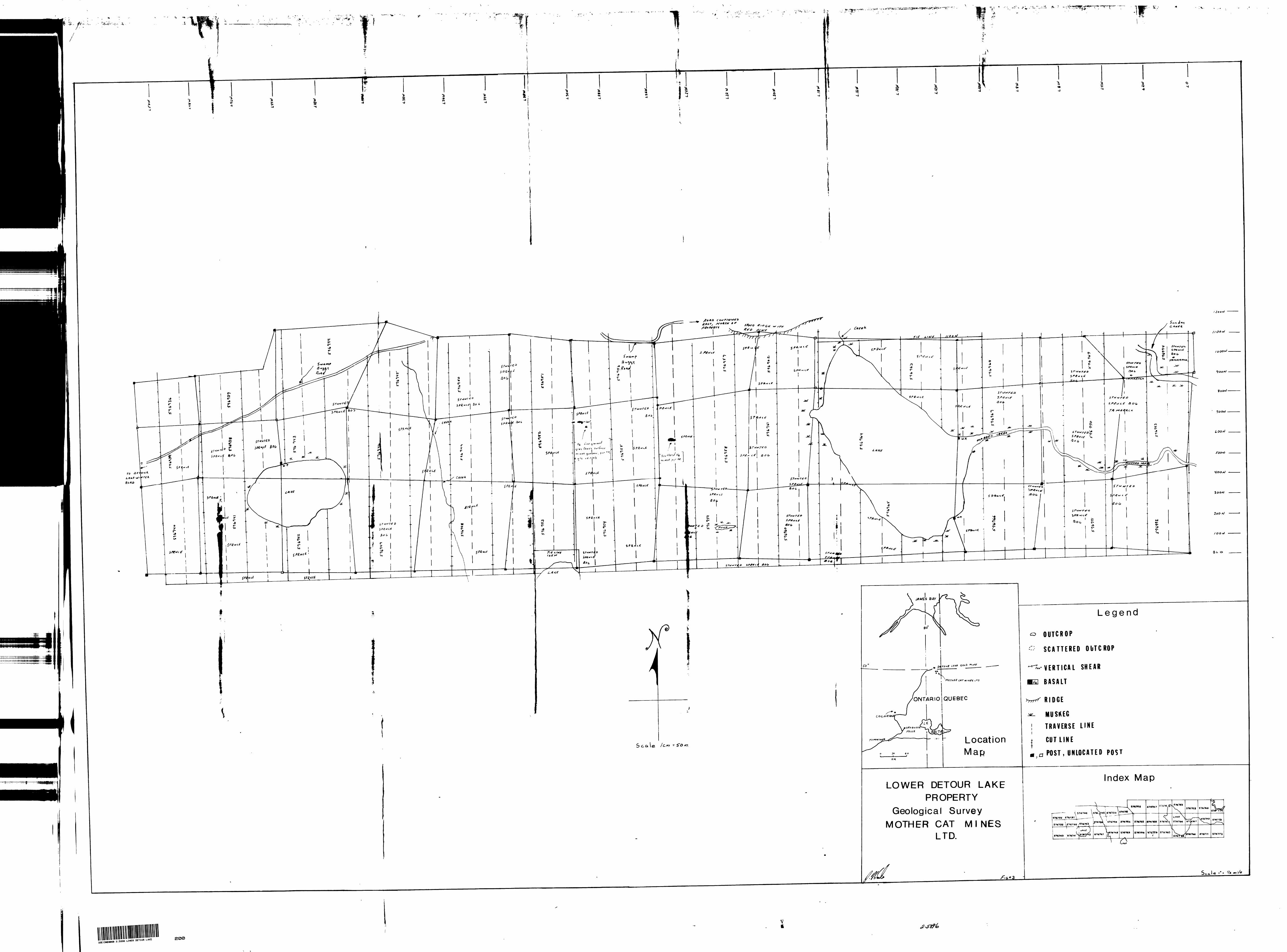
F-cg. #7 ——- Piop&ity Location MapPig. #2 ——— C^a^m Location. tJapfig. #3 ——— Ge.ologi.cai Map

-J-
INTRODUCTION
During the Fall of 1983, Filo Exploration
Services conducted a geological survey over Mother
Cat Mines, Lower Detour Property. The Lower Detour
Property is situated adjacent to the recently deve
loped Amoco-Campbell Red Lake Gold Mine.
This particular orebody is hosted within
intercalated felsic and ultramafic volcanics.
Considering the proximety of the property to the
Detour Lake Mine a geological survey was initiated to
ascertain whether a similar geological environment
exists on the Mother Cat claim group.
Survey techniques, results and recommenda
tions for further exploration are discussed in the
following text.
PROPERTY & OWNERSHIP
The property consists of thirty-nine (39)
contiguous mining claims numbered 576736 to 576774
inclusive. These claims are situated in the Lower
Detour Lake Area, Porcupine Mining Division, District
of Cochrane.
This claim group is owned soley by Mother
Cat Mines Limited, 4 Davenport Avenue, Greenwich, CT,
U.S.A.
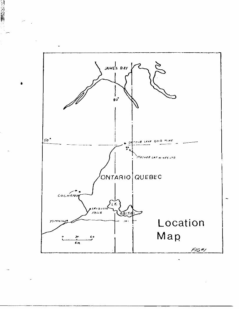
Location Map
f/G*/

-2-
LOCATION b ACCESS
The property is situated approximately 140
kilometers northeast of Cochrane, Ontario, adjacent to
the Detour Gold Mine.
Access to this property is attained by an all-
weather gravel road to the Detour Mine Site and then via
swamp buggy to the northwestern edge of the property.
The property is also accessable by float equipped air
craft from an airbase in Cochrane, Ontario.
PROPERTY HISTORY
Portions of the Mother Cat claim group were
owned at one time by both Noranda Exploration and Amoco
Petroleum. Amoco owned a small portion of ground along
the northeast edge of the Mother Cat group. No
record assessment work was available for these particular
claims. In 1976, Noranda carried out a limited geo
physical and diamond drill program over the northeastern
portion of the Lower Detour Property. Only one conductor
was tested; this conductor was caused by graphite and
disseminated sulphides, no gold values were detected.
(Assessment File T-1729)
In 1982 the previous owner of the Mother Cat
claims (A. Martin) had an airborne geophysical survey
flown over the entire property. Only one promising
conductor was located. This particular conductor is in
the extreme northwest section of the property.
(Delina, F. , 1982)

a03
x0
TDC

-3-
TOPQGRAPHY 4 RESOURCES
The majority of this property is covered
by low lying spruce and alder swamp. A few small
sand ridges and rock outcrops also exist. The only
known resources to date on this property are a few
stands of spruce and red pine. An ample supply of
fresh water from lakes and streams is also available,
SURVEY PARAMATERS
An east-west baseline was cut along the
southern boundary of the property. This baseline was
bisected by north-south crosslines every 200 meters.
Stations along the crosslines were located at 25 meter
intervals.
The cut lines were traverse^ from north tu-south
as were pace and compass lines which were interstitial to
cut lines. All topographic features and outcrop were
tied into" the control grid.

Table #1 TABLE OF LITHOLOGIC UNITS FOR THE BURNTBUSH-DETOUR LAKES AREA
PHANEROZOIC
CENOZOICQUATERNARY
RECENT
Swamp, stream and lacustrine depositsPLEISTOCENE
Till, clay, sand, and gravel deposits
Unconformity PRECAMBRIAN
LATE PRECAMBRIAN (PROTEROZOIC) MAFIC INTRUSIVE ROCKS
Quartz Diabase
Intrusive Contact EARLY PRECAMBRIAN (ARCHEAN)
MAFIC TO INTERMEDIATE INTRUSIVE ROCKS Diorite
FELSIC TO INTERMEDIATE INTRUSIVE ROCKS
Quartz monzonite, granodiorite, granite, quartz diorite, feldspar porphy ry, quartz-feldspar porphyry, gneiss, pegmatite, felsite, trondhjemite
Intrusive Contact
METAMORPHOSED MAFIC AND ULTRAMAFIC INTRUSIVE ROCKSGabbro, amphibolite, porphyritic gabbro, ultramafic rocks (not exposed)
Intrusive Contact
METASEDIMENTSCHEMICAL METASEDIMENTS
Ironstone, chertCLASTIC METASEDIMENTS
Wacke, arenite, arkose, calc-silicate rocks, grit, fine-grained to very fine grained graphitic metasediments and tuffs, schist
METAVOLCANICSFELSIC TO INTERMEDIATE METAVOLCANICS
Flow, tuff, lapilli-tuff, pyroclastic breccia, tuff-breccia, porphyryitic flows.MAFIC TO INTERMEDIATE METAVOLCANICS
Flow, tuff, lapilli-breccia—pyroclastic breccia, amphibolite, pillowed and porphyritic flows, pillow breccia
13

-4-
REGIDNAL GEOLOGY
An excellent account of the regional geology
of the Burntbush-Oetour Lake Area is given in an Ontario
Geological Survey Report by Johns G.W., (1982). The
following excerpt has been taken from this report to
describe this area's regional geology:
"The sequence of rocks in the Detour Lake Area consists; of Pre-Cambrian mafic to felsic metavolcanics and metasediments of the Abitibi Greenstone Belt. The metavolcanics and metasediments of this area were later intruded by both felsic and mafic plutons and dykes.
The mafic metavolcanics are fine grained and have well preserved primary structures. The main lithologic types are as follows: flows, tuffs, pillow flows with autoclastic breccia, lapilli-breccia to pyroclastic breccia and porphyritic flows.
The felsic to intermediate units are not exposed in outcrop and have b( nn delineated using diamond drill hole logs md ODM-GSC aeromagnetic maps. Chemically all the felsic to intermediate metavolcanics are calc-alkaline rhyolites and dacites with minor tholeiitic dacite.
The clastic metasediments are found stratigraph- ically above the metavolcanics. Diamond drill logs also show that they are interbedded with metavolcanics.
The metamorphosed mafic and ultramafic intrusive rocks consist of gabbro, porphyritic gabbro and amphibolite. These occur as feeder dykes and sills. The ultramafic intrusive rocks are not exposed on the surface.
The felsic to intermediate Intrusive rocks are mainly quartz monzonites th;at are occasionally pegmatitic.

-5-
REGIONAL GEOLOGY cont'd
The metavolcanic-metasedimentary rocks of the northern supracrustal belt in the Detour Lake Area lie at or within the nose of a fold structure which extends west from the main body of the Abitibi volcanic belt in Quebec. The northern supracrustal belt is isoclinally folded into an anticline and a series of antiforms and synforms. The emplao. oient of the Detour Lake diorite warped the fold axes and induced miner folding in tt o metavolcanics surrounding the body. The anticline found north of Detour and Lower Detour Lakes plunges .gently to the northwest at about 45 degress. The location of the axis of the anticline is delineated by lithologic changes found in diamond drill logs and opposing pillow tops found on the north and south limbs.
Major faults have not been proposed for the map area because the amount of outcrop is insufficient and the overburden too deep for such interpretation.
Foliation in the Detour Lake Area tends to parallel bedding and is defined by the planar orientation of platy and acicular minerals such as biotite, chlorite, muscovite and amphibole and by flattening of clasts and pillows.
The rocks in the Detour Lake Area have under gone regional and contact metamorphism, ranging from upper greeschist almandine amphibolite facies." (Johns, G.W. O.G.S. Report #199)

-6-
PRDPERTY GEOLOGY
The majority of the Lower Detour Property
is covered by muskeg and glacial debris; less than two
percent exposure was found on the property. As a
result much of the geological picture on this property
is purely conjectural.
The recent geological survey results and
assessment file data suggest that the majority of the
property is underlain by intercalated mafic volcanics
and metasedimen t s. It appears that the sedimentary
volcanic content strikes northwest across the central portion
of the property. (O.G.S. Map 2453 b Personal Field Work)
The volcanics found during the course of the
survey were fine grained basalts; these basalts are
massive and have a grey colour on a fresh surface. These
mafic volcanics have a fairly massive appearance and the
only real structure noted was a pronounced vertical
east-west shear on the exposures at L30W 750N.
No real signigicant mineralization was found
except for some minor pyrite and associated gossan.
CONCLUSIONS
Considereing the minimal exposure and the
size of this property it is very difficult to evaluate
the economic possibilities for this area on geological
data alone. However, preliminary survey results show
that a favourable geological environment for gold
mineralization in the Detour Camp is known to be
associated with intercalated mafic and felsic volcanics,

-7-
CONCLU5IONS cont'd
A more substantial evaluation of this property's
mineral potential will be made upon completion of
geophysical reports.
RECOMMENDATIONS
(1) A limited trenchin^ and stripping program
should be initiated in order to better expose and sample
known rock exposures.
(2) Further geophysical surveys will be considered
for this area providing favourable results are obtained
from the preliminary magnetic and V.L.F. surveys.
itted
H. B Se

BIBLIOGRAPHY
-8-
Defoma. F.
1982 Airborne Electromagnetic Survey,
Detour Lake Ont., MPH Consulting
Ltd., 17p
Jackson, A
1980 Discovery Case History of the
Detour Lake Gold Deposit; C.I.M.
Paper #41, 9p
Johns, G.W
1982 Geology of the Burntbush - Detour
Lake Area, Dist, of Cochrane, Ont.
Geological Survey Report 199, 82p
Accompanied by Map 25431, scale
l to 100,000
O.D.M. Assessment Files

-9-
CERTIFICATE
I, John Kevin Filo of Timmins, Ontario hereby
certify that:
1) I hold an Honours BSc. degree in Geology
from Laurentian University, Sudbury, Ont. (1980)
2) I have practiced my profession in exploration
continuously since graduation.
3) I have based my conclusions and recommendations
contained in this report on knowledge of the
area, my previous experience and on the results
of field work conducted on the property during
September 1983, which was carried out under my
supervision.
4) I hold no interest in the Mother Cat Mining
Limited nor do I expect to receive any interest
in the property other than my professional
fees.
JKK. Flloy H'.H. BSc.

/l J fin r. 2.0
Ontario
Report of Work(Geophysical, Geological, Geochemical and Expenditures)
- -- - - ,, .. . . .... , m v, i, ,BM|| g •Bill l IBIII l l
32EI3NE8068 3.5896 LOWER DETOUR LAKE
The Mining Act — J -in the "Expend. Days Cr." columns.
— Do not use shaded areas below.l ypc of Survey(s)
GEOLOGICAL. SURVEY^Claim Holder (s)
ANGUS MARTIN
Township or Area ;
LOWER DETOUR LAKEProspector's Licence No.
R.R. //l, Dalton Road, Timmins, OntarioSurvey Company
INGAMAR EXPLORATIONS LIMITEDName and Address of Author (of Geo-Technical report)
Date of Surrey (from fi* lo)
20 . Oft. 83 l 05 .09 83Do y J McT [ Yr. j Day | Mo. | Yr.
Total Milos o* line Cut
35 miles
KEVIN J. FILD. 143 DOME AVE. S. PORCUPINE. ONTARIOCredits Requested per Each Claim in Columns at rightSpecial Provisions
For first i
Enter 40 days. (This includes line, cutting) ( t
btP 2 ^For each additional survey:
Enter 20 days (for each)
1983
Man Days
Complete and enter
PORCUPINE M
A.M.
i omagnetic
Magnetometer
Radiometric
Geological
Geochemical
III -MnetoHtK-i
rfomptric
- Magn
P.M.
Days per Claim
40
Days oof Claim
Airborne Credits
Note: Special pu
credits do to Aiiborn
Expenditures (excTypo of Work Perfoi
Geological
Geochornical
viimns
ofCwl
PORC UPINE MINING OlVlilON t: -----magnetic: —
Days per aim
pys. Tlagnetometer
stripping)
Mining Claims Traversed (List in numerical sequence)
Performed on Claim(s)
Calculation of Expenditure Days
Total Expenditures
O R D R
SE? ?.' : ^-'Total
.. ...Dayi.Credits—
4- 15 ^
InstructionsTotal Days Credits may be apportioned at the claim holder's choice. Enter number of days credits par claim selected in columns at right.
•,
Mining ClaimPrefix
P
,
Number
576736
576737
576738
576739
576740
576741
576742
-5.76743.........
576744
576745
576746 .^
.57.6747,. —
576748
576749
576750
576751
576752......
576753
576754
576755 —^
576756
576757
576758
Expenrl. Days Cr.
- ——————
——————
- ————— -
X&S
(V"Prefix
p
/?*Y^
lining ClnimNLJ mher
576759
576760
57.6.761........
576762
576763^^ ..
516764-
576765
576.7.6.6.. ..
576767
576768
5.76769......
576.770........
576771
576772
576773
5 76 7 .74 —..
\^U2^~ -j-r- — S jts3VL*vP~
C xpend. Dnys Cr.
-- ——— -
-—— — -
yTc t aJ(3i^r*(t)^r*6F-fri"i n'i n g
^^^^/arfTis covered by This ^ ^ •^^/eport of work.
Certification Verifyipg^fj0ort of Work
l hereby certify that l have a personal and intimate knowledge of the facts set foith in the Report of Work annexed hereto, having performed the woik or witnessed same during and/or after its completion and the annexed report is true.
NaniH and Postal Address of Person Certifying
MAURICE HIBBARD
CEDAR HILL, CONNAUGHT, ONT. RON 1AO
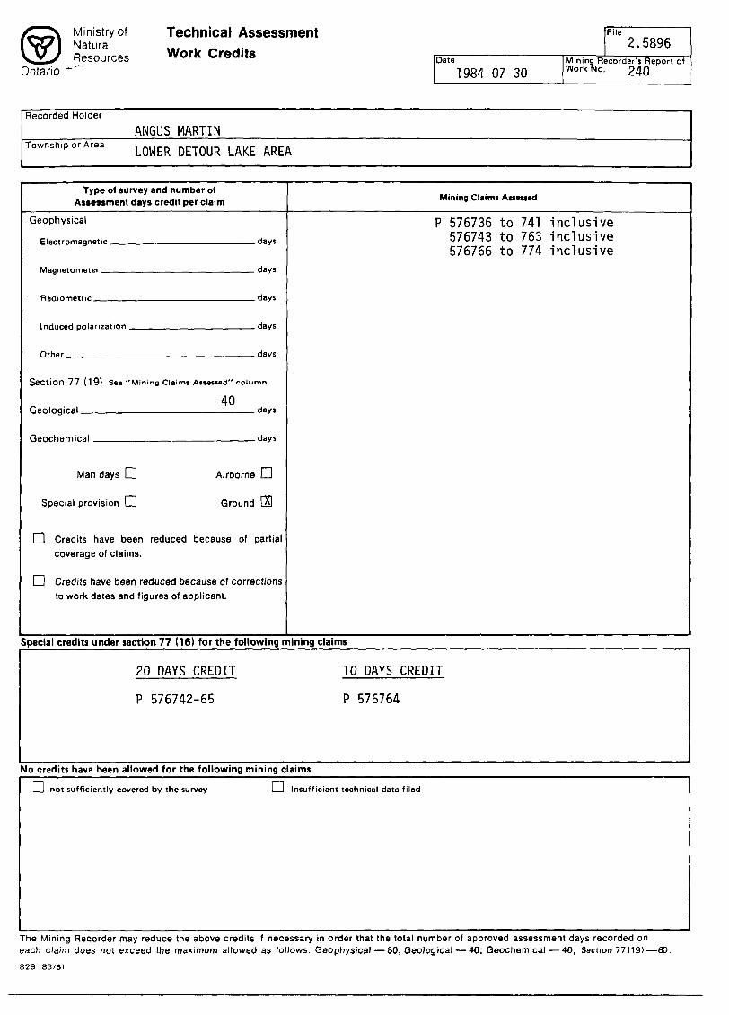
fc^\ Ministry or Technical Assess ISJ Sees Work Credit,Ontario "'
ment Fi" 2.5896Date Mining Recorder's Report of
1984 07 30 workfto. 240
Recorded Holder
ANGUS MARTINTownsh.porArea IQ^R ^^ ̂ ̂
Type of survey and number of Assessment days credit per claim
Geophysical
Section 77 (19) See "Mining Claims Assessed" column
40Geological day*
Man days l~l Airborne CH
Special provision LJ Ground [S
[~| Credits have been reduced because of partial coverage of claims.
Q Credits have been reduced because of corrections to work dates and figures of applicant.
Mining Claims Assessed
P 576736 to 741 inclusive 576743 to 763 inclusive 576766 to 774 inclusive
Special credits under section 77 (16) for the following mining claims
20 DAYS CREDIT 10 DAYS CREDIT
P 576742-65 P 576764
No credits have been allowed for the following mining claims
1 — l not sufficiently covered by the survey 1 — 1 Insufficient technical data filed
The Mining Recorder may reduce the above credits if necessary in order that the total number of approved assessment days recorded on each claim does not exceed the maximum allowed as follows: Geophysical — 80; Geological — 40; Geochemical — 40; Section 77(19)—60:
828 (83/6)

Ontario —
Geotechnical ""PortApproval
F,le
Mining Lands Comments
J
To: Geophysics
Comments
Approved Wish to see again with correctionsDate Signature
tr To: Geology - Expenditures
Comments
j Approved Q] Wish to see again with correctionsDate
AeSignature
To: Geochemistry
Comments
[^Approved [^jWish to see again with correctionsDate Signature
To: Mining Lands Section, Room 6462, Whitney Block. (Tel: 5-1380)
1593 (81/10)

Ministry ofNaturalResources
1984 07 30 Your File: 240Our File: 2.5896
Bruce W. HanleyMining RecorderMinistry of Natural Resources60 Wilson AvenueTimmins, OntarioP4N 2S7
Dear Sir:
Enclosed are two copies of a Notice of Intent with statements
listing a reduced rate of assessment work credits to be allowed
for a technical survey. Please forward one copy to the recorded
holder of the claims and retain the other. In approximately fifteen days from the above date, a final letter of approval of
these credits will be sent to you. On receipt of the approval letter, you may then change the work entries on the claim record
sheets.For further information, if required, please contact
Mr. R. J. Pichette at 416/965-4888.
Yours sincerely,
S.E. YundtDirectorLand Management Branch
Whitney Block, Room 6643 Queen's Park Toronto, Ontario M7A 1W3
. Hurst:mc
Encls.
cc: Angus Martin R.R.#1 Dalton Road Timmins, Ontario P4N 7C2
cc: Mr. G.H. FergusonMining S Lands Commissioner Toronto, Ontario
845

Ministryof Notice of Intent NaturalResources for Technical Reports
Ontario1984 07 30
2.5896/240
An examination of your survey report indicates that the requirements of The Ontario Mining Act have not been fully met to warrant maximum assessment work credits. This notice is merely a warning that you will not be allowed the number of assessment work days credits that you expected and also that in approximately 15 days from the above date, the mining recorder will be authorized to change the entries on his record sheets to agree with the enclosed statement. Please note that until such time as the recorder actually changes the entry on the record sheet, the status of the claim remains unchanged.
If you are of the opinion that these changes by the mining recorder will jeopardize your claims, you may during the next fifteen days apply to the Mining and Lands Commissioner for an extension of time. Abstracts should be sent with your application.
If the reduced rate of credits does not jeopardize the status of the claims then you need not seek relief from the Mining and Lands Commissioner and this Notice of Intent may be disregarded.
If your survey was submitted and assessed under the "Special Provision-Performance and Coverage" method and you are of the opinion that a re-appraisal under the "Man-days" method would result in the approval of a greater number of days credit per claim, you may, within the said fifteen day period, submit assessment work breakdowns listing the employees names, addresses and the dates and hours they worked. The new work breakdowns should be submitted direct to the Land Management Branch, Toronto. The report will be re-assessed and a new statement of credits based on actual days worked will be issued.
846 (82/5)

INGAMAR EXPLORATIONS LIMITEDCEDAR HILL CONNAUGHT. ONTARIO TON 1AO
TEL. (705) 433-3551 or (705) 264-3100
TELEX 067-81502
l^SVEDMAILED VIA SPECIAL DELIVERY - . :; -;:r,ent Branch
July JIB,, 1984
R. PichetteLand Management BranchMinistry of Natural ResourcesWhitney Block, Room 6643Queen's ParkTORONTO, ONTARIOM7A 1W3
SUBJECT: YOUR FILE: 2,5896 7561-1V2 Porcupine Mining Division _______Work Credits on Mining Claims P 376736 to 774 inclusive
Dear Mr. Pichette:
Further to our telephone conversation of July 18, I am enclosing the maps for the above property as requested.
Thank you.
Sincerely,INGAMAR EXPLORATIONS LIMITED
Xi-L.t, Kevi(/ J.'^rilo, Geologist
KJF/ab Enc.

July 18, 1984 Your File: 240Our File: 2.5896
Mr. Bruce HanleyMining RecorderMinistry of Natural Resources60 Wilson AvenueT1mn1ns, OntarioP4N 2S7
Dear Sir:
RE: Geological Survey submitted on Mining CIalas P 576736 et al 1n the Lower Detour Lake Area
As per a telephone conversation of July 18, 1984, (Hall-P1chette), please disregard my letter of July 9, 1984, authorizing the deletion of 40 days Geological assessment work credits recorded on September 21, 1983.
The claim holder Mill be submitting the Information as requested In our letters of January 6, 1984 and June 5, 1984.
Yours sincerely,
S. E. YundtDI rectorLand Management Branch
Whitney Block, Room 6643 Queen's Park Toronto, Ontario M7A 1W3 Phone:(416)965-6918
R. P1chette:sc
cc: Ingamar Explorations Limited Cedar Hill Connaught, Ontario RON 1AO

1984 07 09 Your File: 240Our File: 2.5896
7561.lV2
Mr. Bruce W. HanleyMining RecorderMinistry of Natural Resources60 Wilson AvenueTimmins, OntarioP4N 2S7
Dear Sir:
Angus Martin recorded 40 days Geological assessment work credits on each of Mining Claims P 576736 to 774 Inclusive on September 21, 1983.
Additional Information has been requested from the claim holder and not submitted.
You are hereby authorized to delete the work credits recorded on September 21, 1983 from each of the claim record sheets. Please Inform the recorded holder accordingly.
Yours sincerely,
S.E. YundtDirectorLand Management Branch
Whitney Block, Room 6643 Queen's Park Toronto, Ontario M7A 1W3 Phone:(416)965-4888
S. Hurst:mc
cc: Ingamar Explorations Limited Cedar Hill Connaught, Ontario PON 1AO
cc: Angus MartinR.R.I1 \ Dalton Road l Timmins, Ontario P4N 7C2

1984 07 09 7561.lV22.5896
Resident GeologistMinistry of Natural Resources60 Wilson AvenueTimmins, OntarioP4N 3W2
Dear Sir:
RE: Geological Survey submitted on Mining Claims P 576736 et al 1n the Lower Detour Lake Area
Further to my letter of October 24, 1983 which acknowledged receipt of the above-mentioned survey, the enclosed file has not been assessed as all necessary Information was not submitted.
Yoans sincerely,
S.E. YundtDirectorLand Management Branch
Whitney Block, Room 6643 Queen's Park Toronto, Ontario M7A 1W3 Phone:(416)965-4888
S. Hurst:me
cc: Mining Recorder Timmins, Ontario
Encl.

REGISTERED
June 5, 1984 File: 2.5896
Angus Martin R.R.#1 alton Road Tlmnins, Ontario P4N 7C2
Dear Sir:
RE: Geological Survey submitted on Mining Claims P 576736 et al In the Area of Lower Detour Lake
Enclosed 1s a copy of our letter dated January 6, 1984, requesting additional Information for the above-described survey.
Unless you can provide the required data by June 20, 1984 the raining recorder will be directed to cancel the work credits recorded on September 21, 1983.
For further Information, please contact Mr. Ray Plchette at (416)965-4888.
Yours sincerely,
S.E. YundtDirectorLand Management Branch
Whitney Block, Room 6643 Queen's Park Toronto, Ontario M7A 1W3 Phone:(416)965-4888
S. Hurst:me
cc: Mining Recorder Timmins, Ontario
End.

January 6, 1984 Our File: 2.5896
Angus Martin R.R.#1 Dalton Road Timmins, Ontario P4N 7C2
Dear Sir:
RE: Geological survey submitted on Mining Claims P 576736 et al in the Area of Lower Detour Lake
Enclosed are the plans, in duplicate, for the above-mentioned survey. Please show all claim lines and claim numbers, colour code indicated geological outcrops and return maps to this office.
For further information, please contact Mr. F.W. Matthews at {416)965-1330.
Yours very truly,
J.R. MortonActing DirectorLand Management Branch
Whitney Block, Room 6643 Queen's Park Toronto, Ontario M7A 1W3 Phone:(416)965-1380
M.E. Anderson:me
cc: Mining Recorder Timmins, Ontario
Encl.

1984 08 24 Your File: 240 Our File: 2. 5896
Mr. Bruce HanleyMining RecorderMinistry of Natural Resources60 Wilson AvenueTimmins. OntarioP4N 2S7
Dear Sir:
RE: Notice of Intent dated July 30. 1984.Geological Survey on Mining Claims P 576736 et al In the Lower Detour Lake Area.
The assessment work credits, as listed with the above mentioned Notice of Intent, have been approved as of the above date.
Please Inform the recorded holder of these mining claims and so Indicate on your records.
Yours sincerely.
S. E. YundtDirectorLand Management Branch
Whitney Block. Room 6643Queen's ParkToronto* OntarioM7A 1W3Phone: (416) 965-6918
S. Hurst: se
cc: Ingamar Explorations Limited Cedar Hill Connaught, Ontario PON 1AO
cc: Mr. 6. H. FergusonMining A Lands Commissioner Toronto, Ontario
cc: Angus Martin R. R. 11 Dalton Road TlMlns, Ontario P4N 7C2
cc: Resident Geologist Timmins, Ontario

240
1983 10 24 2.5896
Mining RecorderMinistry of Natural Resources60 Wilson AvenueTlnmlns, OntarioP4N 2S7
Dear Sir:
He have received reports and maps for a Geological survey submitted under Special Provisions (credit for performance and Coverage) on mining claims P 576736 et al In the Area of Lower Detour Lake.
This material will be examined and assessed and a statement of assessment work credits will be Issued.
Yours very truly,
E.F. AndersonDirectorLand Management Branch
Whitney Block, Room 6643 Queen's Park Toronto, Ontario M7A 1W3 Phone:(416)965-1380
R. P1chette:mc
cc: Angus Martin R.R.fl Dal ton,Road Timmins, Ontario

INGAMAR EXPLORATIONS LIMITEDCEDAR HILL CONNAUGHT, ONTARIO TON IAO
TEL. (705) 433-3551 or (705) 264-3100
TELEX 067-81502
October 12, 1983
Land Management Branch Whitney Block, Room 6450 Queen's Park Toronto, Ontario M7A 1W3
SUBJECT: GEOLOGICAL SURVEY ON MINING CLAIMS P-576736 et al in Lower Deour Lake Area.
Gentlemen:
Enclosed are two copies of the above Geological Survey and Report of Work.
Thank you.
Sincerely, INGAMAR--E.XPLORATIONS LIMITffi
launce Hibbard, PresidentEnc.MH/ab
**Mother Cat

V-
37X
L/
A4-.h/
fiXxl/
IX
x -Z2.v/
x l/
xv/
s
ZZ3L-9
x
7
f- fi
l
-i
is!**" f "** 1
Tto.
^fvi
Legend
o OUTCROP
SCATTERED OUTCROP
"--VERTICAL SHEAR
BASALT
MUSKEG
1 TRAVERSE LINE
Location Map
CUT LINE
- a POST, UNLOCATED POST
LOWER DETOUR LAKEPROPERTY
Geological SurveyMOTHER CAT Ml NES
LTD.
Index Map
fi t* 3
576744 \ 57* /745 STS1SO
V
BBS LOWER DETOUR LAKE 200