Lower Clapton Road/Urswick Road junction changes · Lower Clapton Road/Urswick Road junction...
36
Lower Clapton Road/Urswick Road junction changes Consultation Report August 2017
Transcript of Lower Clapton Road/Urswick Road junction changes · Lower Clapton Road/Urswick Road junction...

Lower Clapton Road/Urswick Road junction changes
Consultation Report August 2017

2
Contents
Executive summary ..................................................................................................... 3
1. About the proposals ............................................................................................ 4
2. About the consultation ...................................................................................... 11
3. About the respondents ...................................................................................... 14
4. Summary of all consultation responses ............................................................ 18
5. Next steps ......................................................................................................... 28
Appendix A: Consultation questions .......................................................................... 29
Appendix B: Consultation letter ................................................................................. 31
Appendix C: Email to stakeholders ........................................................................... 33
Appendix D: List of stakeholders consulted ............................................................... 34
Appendix E: Summary of modelling results ............................................................... 36

3
Executive summary
Between 1 February and 20 March 2016, we consulted on proposals to to alter the
layout of the junction to remove existing traffic and pedestrian signals. The existing
signals would be replaced by an ‘informal’ roundabout and distinctive informal
pedestrian crossings. This document explains the processes, responses and
outcomes of the consultation, and sets out our planned next steps.
The main themes are highlighted below, with detailed analysis from page 18.
Summary of issues raised during consultation
We received 183 responses to the consultation, of which 55 per cent supported or
partially supported our proposals. There was however, some opposition to the
scheme.
A number of respondents stating that shared space does not work for this
scheme.
A number of respondents commented that the scheme was not suitable for
this particular junction due to the location of local facilities such as the health
centre and doctors surgery nearby.
We received responses from seven stakeholder groups representing a range
of interests. Two stakeholders representing visually impaired people were
strongly against the scheme and the principles behind it.
Next steps
We have been carefully considering our position on the scheme proposed at Lower
Clapton Road/Urswick Road since we consulted in February and March 2016.
Given the significant level of stakeholder concern and the many other competing
priorities for resources across London, we do not plan to proceed at present with this
scheme in its current form. However, we hope to review the layout of the junction to
reduce road danger for people walking and cycling and improve bus journey times as
part of any future scheme, subject to available funding.

4
1. About the proposals
1.1 Introduction
We proposed to alter the layout of the junction to remove existing traffic and
pedestrian signals. They would be replaced by an ‘informal’ roundabout and
distinctive informal pedestrian crossings. The road surface would be raised to help
encourage lower vehicle speeds. However, there would still be a detectable kerb
height between the road and the footway.
The proposed changes had been designed to help the junction operate more
efficiently and are expected to result in improved journey times for all users,
particularly bus services. We also expected that pedestrian crossing times would
improve. The proposals had also been designed to reduce vehicle speeds and
create a more pleasant environment.
1.2 Purpose
We identified a higher rate of collisions at this junction compared to comparable
roads, including a higher rate of collisions involving pedestrians. In addition we know
that, during peak periods and weekends, the junction suffers from vehicle congestion
and long delays for pedestrians to cross the road. Therefore we were seeking to
implement a scheme that will reduce the number of casualties as well as make the
junction more convenient for people to cross.
1.3 Detailed description
Alongside the removal of the existing traffic and pedestrian signals we proposed to:
Widen footways to provide more space for pedestrians and encourage lower
motor vehicle speeds
Re-pave footways, using high quality granite paving
Increase public space outside the Health Centre
Extend loading bay hours on Lower Clapton Road (outside King’s Hall Leisure
Centre)
Loading bay relocation from Lower Clapton Road to Median Road to allow for
a new informal pedestrian crossing point.
Improved street lighting
Additional cycle parking
New trees
New seating
Other new public space amenities, including art features and a table tennis
table

5
A map and computer generated images of our proposals can be seen below:

6

7
1.3.1 Gateway features
We proposed to introduce a new signage feature to the junction, welcoming all
visitors to the area. These will be 1.2 metres high perforated metal signs positioned
next to the crossings and bearing the junction’s name in hollow letters. Their role is
to encourage drivers to give way to pedestrians and to give identity and revive
Hackney’s longstanding arboricultural heritage, promoting the study of individual
trees, shrubs, vines, and other plants.

8
1.3.2 Frequently asked questions
Where has this this type of scheme been introduced previously?
In designing our scheme, we drew inspiration from several successful applications of
the concept. For example, schemes in Bexleyheath (London Borough of Bexley),
and Poynton (Cheshire), have resulted in significant improvements to the junctions,
transforming the urban realm in areas that were previously blighted by traffic
congestion and pollution.
What is an informal roundabout?
A junction constructed to give the visual impression of a roundabout, but without the
accompanying signs and road markings.

9
Is the new junction a roundabout?
The new-look junction is designed as an informal roundabout, but is not a
conventional roundabout in the legal sense. The design intentionally requires drivers
to pass through the junction more slowly and cautiously, as there is no explicit
priority for any users or direction of traffic.
How will the junction help cyclists?
Our analysis shows that currently around 60 per cent of cyclists go through a red
light at this junction, which is significantly higher than the average for other junctions
within London. This indicates that it is not working well for cyclists. The design is
intended to create a slower, more pleasant environment for cyclists to use, with
reduced journey times as a result of the reduced congestion for all users. The flush
central reservation strip on the north side would also allow cyclists to use the middle
of the road if they so choose, something which they are currently doing. We are
proposing additional cycle parking as well as a public pump and cycle maintenance
stand.
What is an informal pedestrian crossing?
Informal pedestrian crossing points, constructed in a contrasting paving material,
would be introduced on all arms of the Lower Clapton Road/Urswick Road junction.
These crossings are so named because drivers often give way to pedestrians though
there is no statutory requirement to do so. Observations at this type of crossing have
shown that a majority of drivers stop to allow a pedestrian to cross, which means that
on average a pedestrian arriving at the informal crossing often does not have to wait,
or waits for a short time, before they are able to cross.
Why has the crossing on the north side been moved?
Our analysis shows a strong desire line, particularly for school children, to cross to
and from Median Road away from the junction. The proposed location of the
crossing better serves this demand. In addition, it allows buses and cyclists to exit
Median Road more easily while the crossing is in use by pedestrians.
What facilities will assist people who are blind or visually impaired?
Throughout the scheme, the distinction between footways and road would be defined
in the usual way by means of a wide and detectable kerb with a minimum 50mm
(approximately 2 inches) height between the two levels. Informal pedestrian crossing
points would be identified with tactile paving on the footway and be paved in a
contrasting material to assist in identifying them to people with visual impairment.
What would be the impact on bus passengers?
Over 3,000 bus passengers per hour travel through the junction. The proposed
changes are expected to reduce delays and result in improved journey time reliability
for all bus passengers.
10
Traffic impact of these proposals
The proposed changes are expected to result in improved journey times for all users,
particularly bus services. They are also expected to deliver a reduction in average
traffic speeds.
We have produced a model of traffic flows and pedestrian movements. The results of
the model show either no difference in journey time or a journey time reduction of up
to a minute for all vehicles passing through the junction. For pedestrians the model
also predicts reduction in the time taken to cross the junction, for all but one of the
crossings. For more detailed modelling results please see our detailed modelling
figures in Appendix E

11
2. About the consultation
2.1 Purpose
The objectives of the consultation were:
To give stakeholders and the public easily-understandable information about
the proposals and allow them to respond
To understand the level of support or opposition for the change/s for the
proposals
To understand any issues that might affect the proposal of which we were
not previously aware
To understand concerns and objections
To allow respondents to make suggestions
2.2 Potential outcomes
The potential outcomes of the consultation were:
Following careful consideration of the consultation responses, we decide to
proceed with the scheme as set out in the consultation
Following careful consideration of the consultation responses, we modify the
proposals in response to issues raised and proceed with a revised scheme
Following careful consideration of the consultation responses, we decide not
to proceed with the scheme
Our conclusion and next steps are set out in Section 5.
2.3 Who we consulted
We consulted local residents, businesses and various stakeholder groups and
emergency services in order to gather opinions with regards to the proposals.
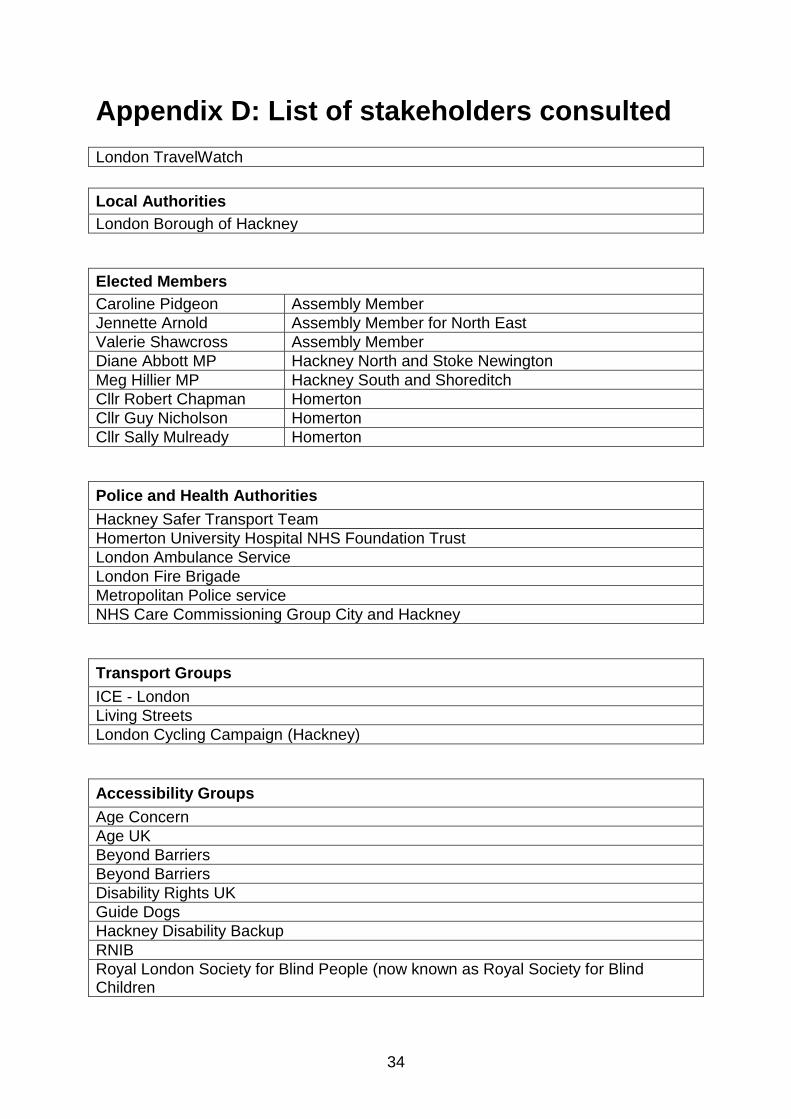
A list of stakeholders that we consulted with can be found in Appendix D
2.4 Dates and duration
The consultation ran for six weeks between 1 February and 13 March 2016.
Following requests from stakeholders the original consultation end date was
extended by one week, with the consultation closing on 20 March 2016.
2.5 What we asked
We asked four questions relating to the proposals and a further 10 generic questions
of the respondent. The respondent did not have to answer all of the questions. Of the
four questions relating to the proposal two were closed questions. The remaining two
were open questions and allowed the respondent was able to answer the questions
with their own views.

12
A list of the questions can be found in Appendix A
2.6 Methods of responding
We accepted responses through the following ways:
Via our website’s online survey
Email to [email protected]
Letter to FREEPOST TFL CONSULTATIONS
2.7 Consultation materials and publicity We launched the consultation on 1 February 2016 by publishing the proposals on a
dedicated consultation page. This was followed by an email sent to stakeholders
inviting them to view the proposals and complete the questionnaire.
2.7.1 Website
The consultation material was published on the consultation page on the TfL
website. The full proposals can be viewed at
https://consultations.tfl.gov.uk/roads/lower-clapton-road.
2.7.2 Letters
A consultation letter was sent out to residents in the local area.
2.7.3 Emails to stakeholders
We sent an email to stakeholders identified as relevant to the area surrounding the
scheme. A copy of this email can be found in Appendix C
2.7.4 Meetings with stakeholders
Government departments, parliamentary bodies & politicians
Councillor Vincent Stops – 17 March 2016
Accessibility Groups
RNIB – 9 March 2016
Hackney Disability Backup – 9 March 2016
Transport and road user groups
Hackney Cycling Campaign – 26 April 2016
2.8 Equalities Assessment
We took steps to ensure that protected groups such as older and disabled people
were aware of the proposals and their potential impacts, and were able to easily
respond to the consultation. Measures taken included identifying and emailing
relevant stakeholders and inviting them to respond to the consultation. A full list of
stakeholders contacted is available in Appendix D. We also met with RNIB on 9
13
March 2016 and Hackney Disability Backup on 9 March 2016 to discuss the
proposals and help them formally respond to the consultation
2.9 Analysis of consultation responses
We commissioned JMP Consultants to analyse the consultation responses. All
closed questions were reviewed and the results have been tabulated and reported.
All open questions, where respondents provided comments on the overall scheme or
parts of it, were read and analysed in detail. Each individual comment was attributed
one or more codes according to the issues raised. The information was also
analysed and tabulated.
All results are reported in Section 3 and Section 4 of this report.
Where more than one response had been submitted from the same person and
email address, these responses were combined before the data was passed to JMP.
Personal data was removed from responses before being passed for analysis in
accordance with data protection laws.
14
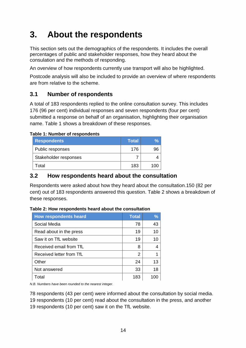
3. About the respondents
This section sets out the demographics of the respondents. It includes the overall percentages of public and stakeholder responses, how they heard about the consulation and the methods of responding.
An overview of how respondents currently use transport will also be highlighted.
Postcode analysis will also be included to provide an overview of where respondents
are from relative to the scheme.
3.1 Number of respondents
A total of 183 respondents replied to the online consultation survey. This includes
176 (96 per cent) individual responses and seven respondents (four per cent)
submitted a response on behalf of an organisation, highlighting their organisation
name. Table 1 shows a breakdown of these responses.
Table 1: Number of respondents
Respondents Total %
Public responses 176 96
Stakeholder responses 7 4
Total 183 100
3.2 How respondents heard about the consultation
Respondents were asked about how they heard about the consultation.150 (82 per
cent) out of 183 respondents answered this question. Table 2 shows a breakdown of
these responses.
Table 2: How respondents heard about the consultation
N.B. Numbers have been rounded to the nearest integer.
78 respondents (43 per cent) were informed about the consultation by social media.
19 respondents (10 per cent) read about the consultation in the press, and another
19 respondents (10 per cent) saw it on the TfL website.
How respondents heard Total %
Social Media 78 43
Read about in the press 19 10
Saw it on TfL website 19 10
Received email from TfL 8 4
Received letter from TfL 2 1
Other 24 13
Not answered 33 18
Total 183 100
15
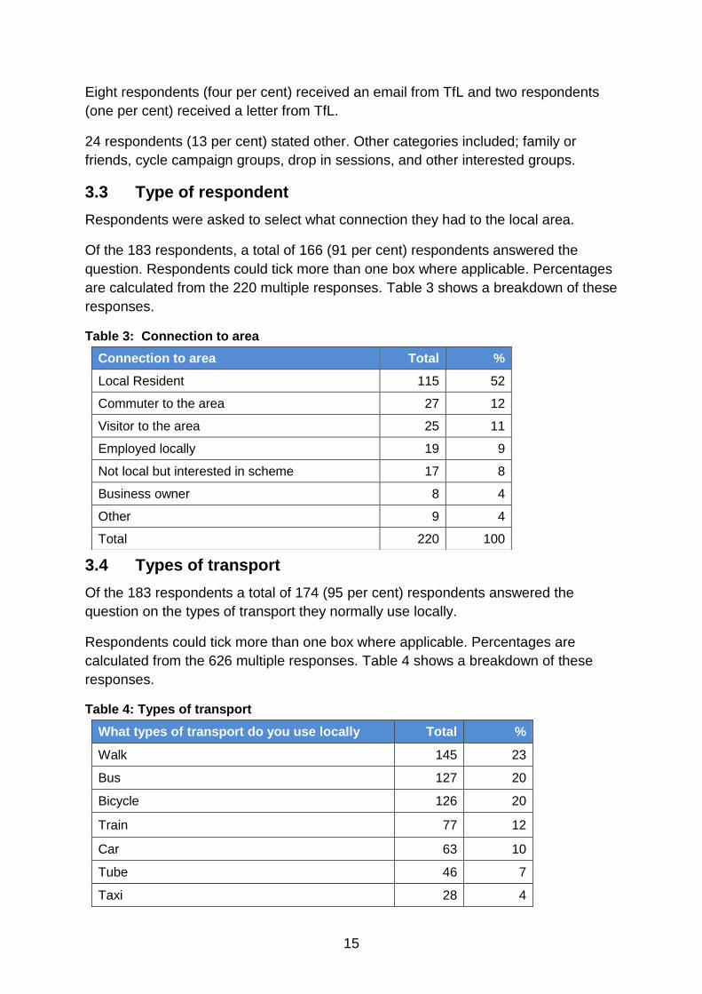
Eight respondents (four per cent) received an email from TfL and two respondents
(one per cent) received a letter from TfL.
24 respondents (13 per cent) stated other. Other categories included; family or
friends, cycle campaign groups, drop in sessions, and other interested groups.
3.3 Type of respondent
Respondents were asked to select what connection they had to the local area.
Of the 183 respondents, a total of 166 (91 per cent) respondents answered the
question. Respondents could tick more than one box where applicable. Percentages
are calculated from the 220 multiple responses. Table 3 shows a breakdown of these
responses.
Table 3: Connection to area
3.4 Types of transport
Of the 183 respondents a total of 174 (95 per cent) respondents answered the
question on the types of transport they normally use locally.
Respondents could tick more than one box where applicable. Percentages are
calculated from the 626 multiple responses. Table 4 shows a breakdown of these
responses.
Table 4: Types of transport
Connection to area Total %
Local Resident 115 52
Commuter to the area 27 12
Visitor to the area 25 11
Employed locally 19 9
Not local but interested in scheme 17 8
Business owner 8 4
Other 9 4
Total 220 100
What types of transport do you use locally Total %
Walk 145 23
Bus 127 20
Bicycle 126 20
Train 77 12
Car 63 10
Tube 46 7
Taxi 28 4

16
N.B. Numbers have been rounded to the nearest integer.
3.5 Postcodes of respondents
134 respondents (73 per cent) chose to give their postcode as part of the
consultation exercise. Table 5 shows a breakdown of these responses.
Table 1: Postcode of respondents
Postcode Total %
E5 60 45
E9 16 12
E8 11 8
E17 9 7
N16 8 6
Other 30 22
Total 134 100
The postcode location of the scheme is E5
The most popular areas from respondents were from Hackney, Walthamstow and
Stoke Newington.
Of these, 60 respondents (45 per cent) stated they had an E5 postcode, 16
respondents (12 per cent) stated they had an E9 postcode and 11 respondents
(Eight per cent) stated they had an E8 postcode.
Nine respondents (seven per cent) stated they had an E17 postcode and eight
respondents (six percent) stated they had a N16 postcode.
30 respondents (22 per cent) were classified as other. Other areas included NW1
and N1.
3.4 Distribution of respondents postcodes to consultation, in
relation to scheme area
Figure 2 shows the distribution of respondents postcodes in relation to the scheme
area.
Van/Lorry 6 1
Motorcycle/Scooter 5 1
Private coach 2 0
Other 1 0
Total 626 100

17
Figure 1: Distribution of respondent’s postcode in the scheme area
= Location of scheme
18
4. Summary of all consultation responses
We received 183 responses to the online consultation survey. Section 3 summarises
the demographic information about our respondents. This chapter provides a brief
summary of each consultation question. There were 2 closed questions and 2 open
text questions that related to the proposals. The remaining question in this section
focused on the the respondents perception of the consultation material. Stakeholder
responses are included with the results of this section, but a summary of their
individual responses are contained in Section 4.5.
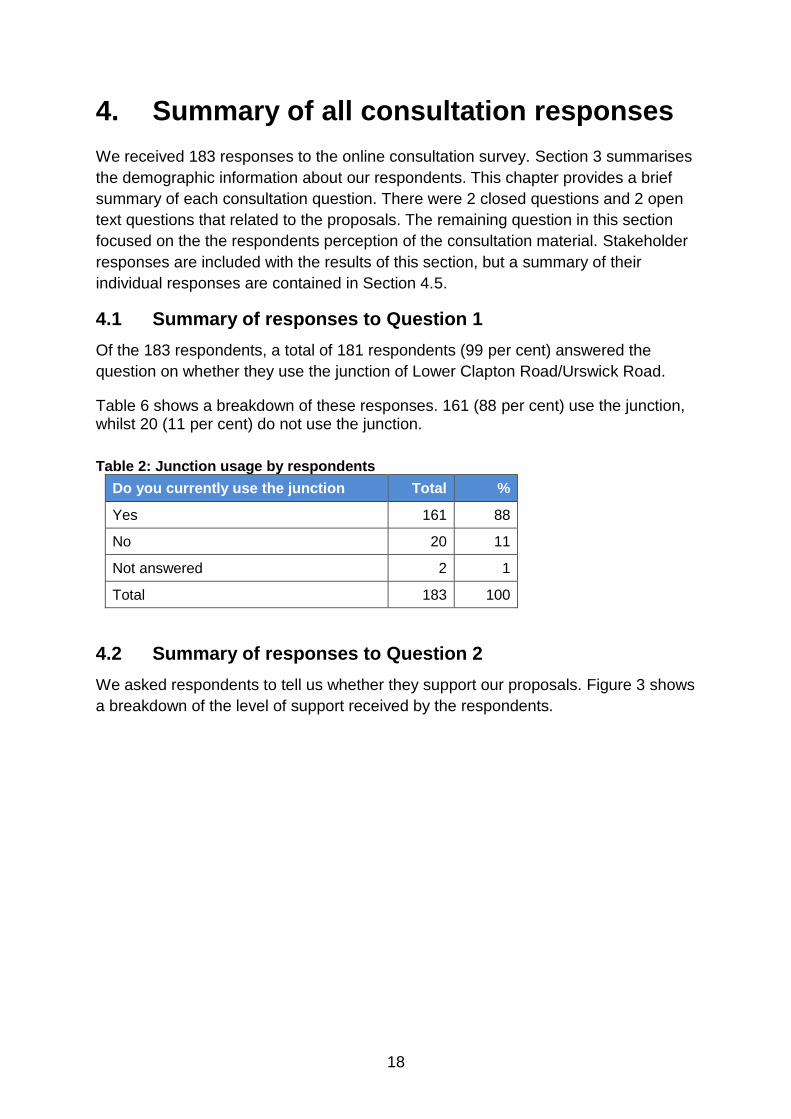
4.1 Summary of responses to Question 1
Of the 183 respondents, a total of 181 respondents (99 per cent) answered the
question on whether they use the junction of Lower Clapton Road/Urswick Road.
Table 6 shows a breakdown of these responses. 161 (88 per cent) use the junction, whilst 20 (11 per cent) do not use the junction.
Table 2: Junction usage by respondents
Do you currently use the junction Total %
Yes 161 88
No 20 11
Not answered 2 1
Total 183 100
4.2 Summary of responses to Question 2
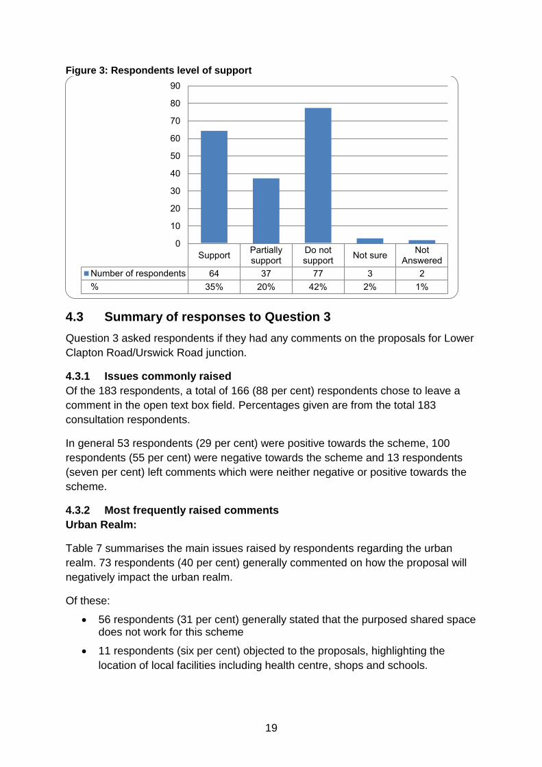
We asked respondents to tell us whether they support our proposals. Figure 3 shows
a breakdown of the level of support received by the respondents.
19
Figure 3: Respondents level of support
4.3 Summary of responses to Question 3
Question 3 asked respondents if they had any comments on the proposals for Lower
Clapton Road/Urswick Road junction.
4.3.1 Issues commonly raised
Of the 183 respondents, a total of 166 (88 per cent) respondents chose to leave a
comment in the open text box field. Percentages given are from the total 183
consultation respondents.
In general 53 respondents (29 per cent) were positive towards the scheme, 100
respondents (55 per cent) were negative towards the scheme and 13 respondents
(seven per cent) left comments which were neither negative or positive towards the
scheme.
4.3.2 Most frequently raised comments
Urban Realm:
Table 7 summarises the main issues raised by respondents regarding the urban
realm. 73 respondents (40 per cent) generally commented on how the proposal will
negatively impact the urban realm.
Of these:
56 respondents (31 per cent) generally stated that the purposed shared space does not work for this scheme
11 respondents (six per cent) objected to the proposals, highlighting the
location of local facilities including health centre, shops and schools.
SupportPartiallysupport
Do notsupport
Not sureNot
Answered
Number of respondents 64 37 77 3 2
% 35% 20% 42% 2% 1%
0
10
20
30
40
50
60
70
80
90

20
Six respondents (three per cent) suggested that a signalised junction should
be built instead
Table 3: Urban realm issues
Issue Total %
Shared space does not work 56 31
Location of facilities (including health centre, school needs to be considered) 11 6
Build a signalised junction 6 3
Pedestrians:
Table 8 shows a summary of the main issues raised for pedestrians. 84 respondents
(46 per cent) generally commented on how the proposal will impact pedestrians,
highlighting other measures.
Of these:
45 respondents (25 per cent) stated that the proposal will make it more
dangerous for pedestrians
26 respondents (14 per cent) suggested that zebra crossings should be
introduced, highlighting the danger of informal crossings
13 respondents (seven per cent) objected the proposal, highlighting the
danger for the visually impaired
Table 4: Pedestrian issues
Pedestrian Issues Total %
Scheme will make the area more dangerous for pedestrians 45 25
Zebra crossing should be introduced where informal crossings are proposed 26 14
Dangerous for visually impaired pedestrian as they will not be able to cross road without formal crossing points
13 7
Cyclists:
Table 9 shows a summary of the main issues raised for cyclists. 59 respondents (32 per cent) generally commented on how the proposal will negatively impact cyclists.
Of these:
28 respondents (15 per cent) suggested that the proposal should include
segregated cycling facilities
23 respondents (13 per cent) generally commented that the proposal will
make it more dangerous for cyclists
Eight respondents (four per cent) objected to the cycle parking in the centre
island
21
Table 5: Cyclists issues
Cyclist Issues Total %
Segregated cycle facilities should be introduced 28 15
Scheme will make area more dangerous for cyclists 23 13
Cycle Parking in centre island will not work/and needs better protection 8 4
Traffic Congestion:
Table 10 shows a summary of the main issues raised for traffic. 31 respondents (17 per cent) generally commented on how the proposal will negatively impact traffic.
Of these:
19 respondents (10 per cent) generally commented that the propsal will not reduce congestion
11 respondents (six per cent) objected the school proposal, highlighting an
increase in more congestion
Table 6: Traffic issues
Local road impact:
Table 11 shows a summary of the main issues raised regarding the local road network. Nine respondents (five per cent) generally commented on how the proposal will negatively impact local road traffic, highlighting more cycling provision.
Of these:
Five respondents (three per cent) objected to any increase in motor traffic on Median Road
Two respondents (one per cent) commented that the proposal should include more cycle route links, highlighting the surrounding area of Lower Clapton Square
Two respondents (one per cent) suggested that more cycling provision (cycle lane) should be made on Median Road
Traffic Congestion Issues Total %
Scheme will not reduce traffic congestion 19 10
Does not want or makes reference to school proposals at police station site 11 6
Traffic calming measures will not work 1 1

22
Table 7: Local road impact
4.4 Summary of responses to Question 4
Question 4 asked respondents if they had any comments on the proposals for the
Gateway Feature Lower Clapton Road/Urswick Road junction.
4.4.1 Issues commonly raised
Of the 183 people who responded to this consultation, 82 respondents (45 per cent) provided a comment in the open text box field on proposals for the gateway feature.
In general 21 respondents (11 per cent) were positive towards the scheme, 50 respondents (27 per cent) were negative towards the scheme and 11 respondents (six per cent) were ‘neither negative or postitive’ towards the scheme.
4.4.2 Most frequently raised comments
Table 12 shows a summary of the most frequently raised issues.
Table 12: Gateway feature issues
Gateway Feature Issues Total %
Looks good and the design is nice 24 13
Concern was expressed that the feature will easily be damaged through either vandalism or road traffic collisions
16 9
Feature does nothing to improve road safety 16 9
Size of the feature is too small and insignificant , and may potentially ‘hide’ children from vehicular traffic when they are crossing road
12 7
Money would be better spent elsewhere (7 stating road safety, 2 Trees and 1 other)
10 5
Feature is not wanted or required 8 4
Concern that the feature will not be illuminated during hours of darkness 5 3
Feature will enhance area 5 3
Design: 24 respondents (13 per cent) generally commented on the design,
highlighting the positives. 16 respondents (nine per cent) expressed concern
that the feature will be easily damaged, highlighting road collisions and
vandalism. Five respondents (three per cent) commented that the feature will
enhance the local area
Local Road Impact Issues Total %
The scheme will increase bus/car traffic of Median road 5 3
Improve cycle links around Lower Clapton Square 2 1
Improve cycling provision (cycle lane) on Median Road 2 1

23
Road safety: 16 respondents (nine per cent) generally commented that they
feature does not improve road safety and 12 respondents (seven per cent)
highlighted the feature is too small
Cost: 10 respondents (five per cent) objected to the cost of the feature whilst
eight respondents (four per cent) commented that the feature is not wanted or
required
Enhancement of the local area: Five respondents (three per cent)
commented that the feature will not me illuminated at night and two
respondents (one per cent) stated that it does not reflect the local area
4.5 Summary of stakeholder responses
This section provides summaries of the feedback we received from stakeholders. We
sometimes have to condense detailed responses into brief summaries. The full
stakeholder responses are always used for analysis purposes.
Emergency services
The London Fire and Emergency Planning Authority (LFEPA) – Support
LFB officers have visited the site and can confirm the proposed work will have
no effect on the LFB
Accessibility Groups
Guide Dogs – Do not support the proposals
Guide Dogs are not in favour of any shared space or informal crossing design,
as they do not give visual impaired people (VIPs) any confidence to cross the
road safely or when it is safe to do so. The lack of tail for the tactile paving
means VIPs will not be able to find the crossing point
A similar scheme installed in Hackbridge was condemned by all and
controlled crossing point was subsequently installed. Guide Dogs would
strongly recommend that this scheme does not go forward and that any
crossing point is controlled.
RNIB – Do not support the proposals
RNIB welcomed the opportunity to respond to the public consultation on
changes to the junction of Lower Clapton Road/Urswick Road. In Hackney
there are over 1,000 people on Hackney’s sight loss register. It did not appear
that TfL made any attempt to engage with local blind and partially sighted
people living in Hackney.

24
The removal of controlled crossings and lowering of kerb heights below
conventional levels, will cause difficulties for blind and partially sighted
residents and need to be reconsidered.
The scheme is at a busy junction with a large number of pedestrians. A lot of
facilities in the area including doctors, health centre, leisure centre and
schools etc, attract a high level of pedestrian footfall especially from
vulnerable user groups.
Blind and partially sighted people will not people able to tell when this is safe
to cross; in order to cross safely they need a controlled crossing point. The
nearest the nearest zebra crossings are some distance away and the signal
controlled crossings will be even further away. This is unacceptable and
discriminates against blind and partially sighted pedestrians.
RNIB noted that the plans show that a minimum 50mm kerb will be installed,
but research in fact recommends 60mm as an effective kerb height enabling
blind and partially sighted people to detect it.
They noted the use of chequered paving materials in this area. TfL will need
to ensure that the footways and carriageway are sufficiently contrasting to
enable all road users to differentiate the two including at times of low
illumination and materials must also be slip resistant in all weather conditions.
To maintain a consistent palette of materials and reduce the number of trip
hazards, future maintenance of the scheme needs to be considered, including
reinstatement works by utility contractors etc.
RNIB welcome a reduction in street clutter and A boards and hope the street
remains as clear as in the visuals
Transport and road user groups
London Cycling Campaign – Do not support the proposals.
This proposal does not offer any safe space for cyclists, with the volume of
traffic using the junction, cyclists should be segregated from motor vehicles to
improve safety for cyclists. For the scheme to be successful it would require
the removal of a dramatic proportion of motor vehicle traffic (including buses)
or a total redesign that separate cyclists from motor traffic, it’s likely this
junction will allow motor vehicle drivers to dominate the environment here.
They believe instead, segregated space for cycling could be included in a
design for this junction – for instance, a cycle track would be feasible onto
Urswick Road given space appears to have already been taken from the
medical centre’s boundary.

25
They also believed that in the current proposals, encouraging cyclists to use
the central reservation puts them into direct conflict with pedestrians crossing
and formalises behaviour that arises out of frustration and fear, rather than
designing for all types of cyclists to ride in comfort.
The London Cycling Campaign also wanted, as a condition of funding, all
highway development designed to TfL’s London Cycling Design Standards
(LCDS), with a Cycling Level of Service (CLoS) rating of 70 or above, and all
“Critical Fails” eliminated. They believed that this scheme likely retains several
critical fails – most notably “hook” risks at the junction.
Cycling Embassy of Great Britain – Do not support the proposals.
The scheme has little benefit for anyone walking or cycling through the area,
and the lack of formal crossing facilities across multiple lanes of traffic is
likely to be concerning for those who are less confident or frail, at the very
least a zebra crossing should be provided on each arm of the junction
The proposals do little to slow vehicular speeds and the mix of cyclists and
motor vehicles in areas, will intimidate cyclists. Cycle routes should be
separated from motor traffic at a junction with such a high volume of motor
traffic
The Confederation of Passenger Transport – Supports the proposals
CPT fully supports measures to improve traffic flow and reduce journey times.
They fully support these changes which we believe will have a positive impact
for all road users locally.
Road layout design – They would like to draw attention to the extended
footways and express their concerns for long vehicles such as coaches
making the turns, particularly Urswick Rd into Lower Clapton Rd, and seek
conformation adequate space will be allowed in the design to allow larger
vehicles to safely make these turns.
Bus Stops - They would welcome coaches and non-TfL buses to be permitted
to set-down and pick-up on at least one stop in either direction at the stops on
Lower Clapton Rd. They understand that there are currently restrictions to
local buses only on these stops. This would greatly assist the safe boarding
and alighting for coaches and home to school transport services in particular.
Hackney Living Streets – Do not support the proposals
Their conclusion is that they cannot support the scheme as proposed, though
they recognise that this is an important junction and would like to support
Hackney Council and TfL to get the right design.
26
There are a lot of vulnerable user groups in the area that use the current
crossing, including users of the health centre, hospital, leisure centre,
secondary and primary school – and people using the shops. It is too
dangerous for shared space and informal crossings to be used across two
lanes of traffic, as this puts pedestrians in danger.
The scheme does not address or seek to minimise the high volume of
vehicular traffic (congestion and pollution) through area, nor does it do
enough to slow traffic speeds.
A Zebra crossing would send a stronger signal to drivers to give way to
pedestrians, and help pedestrians cross. A trial for a “courtesy crossing” that
can be used when needed especially for vulnerable pedestrians could be
used
With regard to the loading bay in front of Kings Hall leisure centre that has
been carved out of the footway, we are pleased to see that it has been raised
to footway level. However, they are concerned that outside loading bay times
it is to be used as a free parking bay. At no time should this be permitted to be
used as a standard parking bay whether free or not.
They are not keen on median strips and prefer to see wider footways and
shorter crossing points. They believe median strips create a dual carriageway
effect encouraging drivers to go faster.
4.6 Comments on the consultation
Question 12 asked respondents if they had any comments on the quality of the
consultation material.
4.6.1 General
71 respondents (39 per cent) provided a comment on the quality of the consultation
and associated materials.
58 (32 per cent) of respondents made neutral or positive comments about the
materials with views such as “excellent”, “very good”, “good” and “okay”
13 (seven per cent) of respondents made negative comments about the materials
with views such as “poor” and “unhelpful”
4.6.2 The most frequently raised issues were:
Of the 71 respondents, 25 (35 per cent) thought the consultation was of good quality,
with concise and informative information
10 (14 per cent) suggested that the pictures provided were of use and helped them
to visualise scheme.

27
Eight (11 per cent) thought the consultation was not publicised enough, and they (or
someone they knew) did not know about the consultation
Four (six per cent) said that the website was good, clear and very detailed.
Three (four per cent) respondents wanted more maps and pictures,
Three (four per cent) respondents wanted more detail on carriageway widths to be
included
Three (four per cent) thought not issuing hard copies of the report was excluding
others from theconsultation.
Two (three per cent) suggested that the pictures were unrealistic
Two (three per cent) suggested the consultation was difficult to fill out on a mobile
phone.

28
5. Next steps
We have been carefully considering our position on the scheme proposed at Lower
Clapton Road/Urswick Road since we consulted in February and March 2016.
Given the significant level of stakeholder concern and the many other competing
priorities for resources across London, we do not plan to proceed at present with this
scheme in its current form. However, we hope to review the layout of the junction to
reduce road danger for people walking and cycling and improve bus journey times as
part of any future scheme, subject to available funding.

29
Appendix A: Consultation questions
Questions about our proposals
1. Do you currently use the Lower Clapton Road/Urswick Road junction?
Yes; No
2. Do you support the proposals for Lower Clapton Road/Urswick Road?
Support; Partially support; Do not support; Not sure; No opinion
3. Do you have any comments on the proposals for Lower Clapton
Road/Urswick Road?
Open text box for respondents own views
4. Do you have any comments on the design of the Gateway feature?
Open text box for respondents own views
Questions about the respondent
5. What types of transport do you normally use locally? (please tick all boxes
that apply)
Walk; Bicycle; Car; Bus; Tube; Train (London Overground/National Rail); Taxi;
Motorcycle/Scooter; Van/Lorry; Private coach; Other (respondents were given
the opportunity to specify other options)
6. What is your name?
7. What is your email address?
8. Please provide us with your postcode
9. Are you? (please tick all boxes that apply)
Local resident; Business owner; Employed locally; Visitor to the area;
Commuter to the area; Not local but interested in the scheme; Other
(respondents were given the opportunity to specify)
10. If responding on behalf of an organisation, business, or campaign group,
please provide us with the name
11. How did you hear about the consultation?
Received an email from TfL; Received a letter from TfL; Read about it in the
press; Saw it on the TfL website; Social media; Other (respondents were
given the opportunity to specify)
12. Please tell us what you think about the quality of this consultation (for
example, the information we have provided, any printed material you have
received, any maps or plans, the website and questionnaire etc.)
13. Are your day-to-day activities limited because of a health problem or disability
which has lasted, or is expected to last, at least 12 months? (Please include
problems related to old age)
Yes, limited a lot; Yes, limited a little; No; Prefer not say
14. If you answered yes to the above question please tell us which category
below best describes your health problem or disability (Please tick all that
apply)

30
Hearing; Vision; Mobility, Other (respondents were given the opportunity to
specify)

31
Appendix B: Consultation letter
Proposed changes to the junction of Lower Clapton Road and Urswick Road Dear Sir/Madam
We are currently consulting on proposals to redesign the junction of Lower Clapton
Road and Urswick Road in Hackney.
We have identified a higher rate of collisions at this junction compared to comparable
junctions, including a higher rate of collisions involving pedestrians. Therefore, we
are proposing a scheme that is designed to reduce the number of casualties, as well
as make the junction more convenient for people to cross. In addition, the proposals
are expected to improve journey times for road users through the junction, which
currently experiences congestion during peak periods and at weekends.
About the proposals
We are proposing to alter the layout of the junction to remove existing traffic and
pedestrian signals. They would be replaced by an ‘informal’ roundabout and
distinctive informal pedestrian crossings. The road surface would be raised to help
encourage lower vehicle speeds. However, there would still be a detectable kerb
height between the road and the footway.
The proposals also include:
Wider footways to provide more space for pedestrians and encourage lower
motor vehicle speeds
Re-paved footways, using high quality granite paving
Increased public space outside the health centre
Extended loading bay hours on Lower Clapton Road (outside King’s Hall
Leisure Centre)
Loading bay relocated from Lower Clapton Road to Median Road to allow for
a new informal pedestrian crossing point.
Improved street lighting
Additional cycle parking
New trees
New seating
Other new public space amenities, including art features and a table tennis
table

32
The proposed changes have been designed to help the junction operate more
efficiently and are expected to result in improved journey times for all users,
particularly bus services. We also expect that pedestrian crossing times would
improve. The proposals have also been designed to reduce vehicle speeds and
create a more pleasant environment
A map showing the proposed changes can be seen in figure 1.
When would these changes take place?
Dependant on the results of the consultation, it would be our intention to start
construction of the scheme in summer 2016. We would write to you nearer the time
to inform you of the start and end dates for the works.
How to comment on these proposed changes
You can find more details and leave feedback on our proposals on our website at
consultations.tfl.gov.uk/roads/lower-clapton-road. You can also write to us at
FREEPOST TFL CONSULTATIONS or via email at: [email protected].
Please let us know your views by 13 March 2016.
Yours sincerely
David Silvey
Consultation Team
Transport for London
33
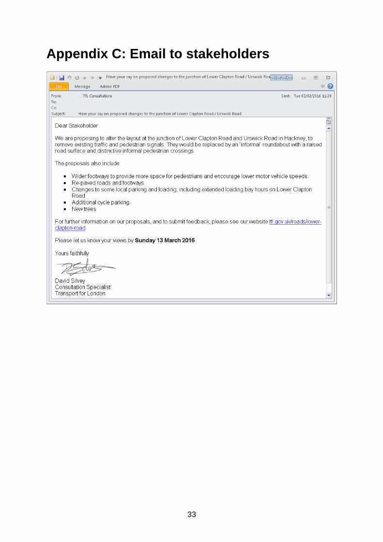
Appendix C: Email to stakeholders
34
Appendix D: List of stakeholders consulted
London TravelWatch
Local Authorities
London Borough of Hackney
Elected Members
Caroline Pidgeon Assembly Member
Jennette Arnold Assembly Member for North East
Valerie Shawcross Assembly Member
Diane Abbott MP Hackney North and Stoke Newington
Meg Hillier MP Hackney South and Shoreditch
Cllr Robert Chapman Homerton
Cllr Guy Nicholson Homerton
Cllr Sally Mulready Homerton
Police and Health Authorities
Hackney Safer Transport Team
Homerton University Hospital NHS Foundation Trust
London Ambulance Service
London Fire Brigade
Metropolitan Police service
NHS Care Commissioning Group City and Hackney
Transport Groups
ICE - London
Living Streets
London Cycling Campaign (Hackney)
Accessibility Groups
Age Concern
Age UK
Beyond Barriers
Beyond Barriers
Disability Rights UK
Guide Dogs
Hackney Disability Backup
RNIB
Royal London Society for Blind People (now known as Royal Society for Blind Children

35
Local Interest Groups
East London Vision
Powerscroft Road Initiative for Neighbourhood Community Environment

36
Appendix E: Summary of modelling results