Lower Brown Hill Creek Channel Upgrade
125
Lower Brown Hill Creek Channel Upgrade Stage 1 - Engineering Feasibility Report - Interim Report Brown Hill Keswick Creek Stormwater Project February 2014 Ref No. 2012.0679FR2D
Transcript of Lower Brown Hill Creek Channel Upgrade

Lower Brown Hill Creek Channel Upgrade
Stage 1 - Engineering Feasibility Report - Interim Report
Brown Hill Keswick Creek Stormwater Project
February 2014
Ref No. 2012.0679FR2D

Ref No. 2012.0679FR2D Lower Brown Hill Creek Channel Upgrade Stage 1 - Engineering Feasibility Report - Interim Report
© Tonkin Consulting 2012
This document is, and shall remain, the property of Tonkin Consulting. The document may only be used for the purposes for which it was commissioned
and in accordance with the Terms of Engagement for the commission. Unauthorised use of this document in any form whatsoever is prohibited.
Document History and Status Rev Description Author Reviewed Approved Date
A For Client Comment JO/CLB MDH 9 August 2013
B Draft for Client Comment CLB 21 August 2013
C Interim Report CLB MDH MDH October 2013
D Interim Report V2 MDH MDH MDH February 2014

Ref No. 2012.0679FR2D Lower Brown Hill Creek Channel Upgrade Stage 1 - Engineering Feasibility Report - Interim Report
Contents
Executive Summary i
1 Introduction 1
2 Lower Brown Hill Creek Description 2
2.1 Lower Brown Hill Creek 2
2.2 Current Planning Zoning 2 2.2.1 Residential Zone 2 2.2.2 Airfield Zone 2
2.3 Current Land Use 2
2.4 Current Ownership 4
2.5 Existing Form 5 2.5.1 Catchment 5 2.5.2 Channel Development 5 2.5.3 Creek Channel 5 2.5.4 Vegetation 11 2.5.5 Significant and Regulated Trees 11 2.5.6 Bridges 12 2.5.7 Services 12
2.6 Access and Circulation 12 2.6.1 Pedestrian 12
2.7 Amenity 15 2.7.1 Grassmere Reserve 16 2.7.2 Watson Avenue 16 2.7.3 Open Space 17
2.8 Biodiversity 17 2.8.1 Flora 17 2.8.2 Fauna 17
2.9 Geotechnical Assessment 19
2.10 Heritage 19 2.10.1 Local Heritage 19 2.10.2 Aboriginal Heritage 21
2.11 Environmental Assessment – Site History 21
3 Community Consultation – Key Issues 22
3.1 Context 22
3.2 Key Issues and Opportunities 23
3.3 Overall Most Desired Elements 24
4 Project Opportunities 25
4.1 Significant Trees 25
4.2 Biodiversity 25
Ref No. 2012.0679FR2D Lower Brown Hill Creek Channel Upgrade Stage 1 - Engineering Feasibility Report - Interim Report
4.3 Amenity 25
4.4 Recreation 26
4.5 Minimise Hard Infrastructure 26
4.6 Minimise Footprint 26
4.7 Improved Connectivity 26
4.8 Public Access 26
5 Channel Upgrade 27
5.1 Introduction 27
5.2 Design Criteria 27 5.2.1 Stormwater Management Plan 27
5.3 Cross Section options 27 5.3.1 Option 1 – Concrete Channel Vertical Sides 28 5.3.2 Option 2 – Box culvert with public access above 29 5.3.3 Option 3 – Gabion-lined open channel 30 5.3.4 Option 4 – Earth Channel 31 5.3.5 Option 5 – Low Flow Channel overtopping box culvert 32 5.3.6 Other Options 32
5.4 Hydraulic Modelling 33
6 Constructability and Opinion of Cost 36
6.1 Construction Cost 36
6.2 Constructability 37
6.3 Property Acquisition 37
6.4 Total Construction cost including Land Acquisition 38
7 Multi-Criteria Analysis 40
7.1 Total Score and Ranking Outcome from MCA Workshop 41
7.2 Discussion 42
8 Project Opportunities and Alternatives 43
8.1 Hydrology 43
8.2 Keswick Bypass Alignment (West Torrens) 43
8.3 Additional Geometry Option – Culvert underlaying an open space flood flowpath 44
9 Recommendations 45
10 References 47
Ref No. 2012.0679FR2D Lower Brown Hill Creek Channel Upgrade Stage 1 - Engineering Feasibility Report - Interim Report
Tables Table 2.1 Significant tree locations within study area 11 Table 5.1 Channel upgrade options summary 35 Table 6.1 Linear metre construction pricing summary excluding land acquisition 36 Table 6.2 Property acquisition cost summary 38 Table 6.3 Total Cost Including Land Acquisition – 60 m3/s peak flow 39 Table 7.1 MCA Workshop Summary 41 Table 8.1 1:100 yr ARI flow (m3/s) in Brown Hill Creek immediately downstream of Anzac
Highway - 43
Figures Figure 2.1 Locality Plan 3 Figure 2.2 Current Land Use 3 Figure 2.3 Current Ownership - East 4 Figure 2.4 Current Ownership - West 4 Figure 2.5 Existing creek - Anzac Highway to South Road 6 Figure 2.6 Existing Creek – South Road to Beauchamp St 7 Figure 2.7 Existing Creek - Downstream Beauchamp St. 8 Figure 2.8 Existing Creek – Grassmere Reserve 9 Figure 2.9 Existing Creek - Marion Rd. to Keswick Creek 10 Figure 2.10 Packard Street Pedestrian Bridge 13 Figure 2.11 Gray Street Pedestrian Bridge 13 Figure 2.12 Beauchamp Street Pedestrian Bridge 13 Figure 2.13 Cross Terrace Pedestrian Bridge 14 Figure 2.14 Location of Pedestrian Bridges 14 Figure 2.15 Bicycle lanes and designated pathways within study area (Source: City of West
Torrens) 15 Figure 2.16 Grassmere Reserve 16 Figure 2.17 Watson Avenue Open Space 17 Figure 2.18 Local Heritage Items adjoining lower Brown Hill Creek (adapted from City of West
Torrens Development Plan 2012) 20
Appendices Appendix A Planning Issues Report Appendix B HEC RAS Results Appendix C Constructability and Cost Estimate Report Appendix D MCA Analysis spreadsheet

Ref No. 2012.0679FR2D Lower Brown Hill Creek Channel Upgrade Stage 1 - Engineering Feasibility Report - Interim Report i
Executive Summary The Stormwater Management Plan (SMP) for the catchments of Brown Hill and Keswick Creeks released in 2012 nominated a number of infrastructure upgrades required to mitigate a 1:100 year Annual Recurrence Interval (ARI) storm event (Worley Parsons 2012). The upgrade addressed in this feasibility study is the lower Brown Hill Creek channel, the boundaries of which are Anzac Highway upstream and the confluence with Keswick Creek downstream. The SMP nominated a design capacity for this section of channel of 60m3/s, whereas the current capacity is nominally 25m3/s.
This report concerns the findings of the feasibility study stage of the design. The purpose of this study is to investigate the technical feasibility of the upgrade as well as the environmental and social impacts.
The existing lower Brown Hill Creek channel is a combination of a natural earth and concrete trapezoidal cross sections with box culverts or bridges at road crossings. The community consultation process has identified a preference for a creek upgrade to incorporate some community benefit such as amenity upgrades, safety improvements and pedestrian and cyclist access.
This study investigated a number of cross section geometry options to accommodate the 60m3/s design flow in terms of hydraulics, cost, environmental impact and social impact. These options included:
Concrete channel with vertical sides
Box culvert with public access or low-flow channel above
Gabion-lined, stepped open channel
Earth-lined trapezoidal channel (Natural channel)
A single culvert underlying on open space floodway.
Leed Engineering and Construction Pty Ltd completed a construction cost estimate of above cross section options, with the lowest cost being the vertical sided open concrete channel which was determined to be $59.8 million including contingencies. In addition to this, the cost of the property acquisition was estimated by Maloney Field Services and estimated conservatively to be between $7.4 million and $60.8 million depending on the cross section option required. However a “best case” scenario cost assuming the majority of the creek upgrade is within the existing creek corridor, favourable location of existing property boundaries and resale of surplus acquired land was estimated to be $2.6 million. A total construction cost including land acquisitions is in the order of $67.2M for the vertical sided channel.
The above options were evaluated using a multi-criteria analysis (MCA) which considered social, environmental and financial factors. The highest ranked option was the earth-lined trapezoidal channel, but all scores were comparable.
During the course of this study, the original hydrology and therefore peak design flow has been reviewed by DPTI as a result of recent changes to Intensity Frequency Duration (IFD) data as part of the 2013 revision of Australian Rainfall and Runoff and revised assumptions in the hydrologic modelling. In addition, the option of a bypass culvert running in the road network to reduce the scope of the main channel upgrade was investigated.
The key outcomes of the study are as follows:
For a design capacity of 60 m3/s, the vertical sided open concrete lined channel for the full length of the creek is the most cost-effective option at an estimated cost of $67.2 million (or $62.4 million with enhanced/rationalised land acquisition)
Other options would also satisfy the design flow capacity, and provide social, environmental and amenity enhancements, but at significantly increased cost ranging from $89 million to $110 million.
Alternatively, enhanced options could be constructed over limited sections of the creek, subject to project cost limitations.

Ref No. 2012.0679FR2D Lower Brown Hill Creek Channel Upgrade Stage 1 - Engineering Feasibility Report - Interim Report ii
Based on revised hydrologic criteria the following options merit detailed investigation of two or more types of channel upgrade design:
Vertical sided open concrete channel (with width for pathway alongside)
Stepped gabion channel
Twin-culvert underlying open space linear path
Single culvert underlying an open space floodway
Based on revised hydrologic criteria the option of a bypass culvert in the road network together with minor upgrades to Lower Brown Hill Creek meant further investigations.

Ref No. 2012.0679FR2D Lower Brown Hill Creek Channel Upgrade Stage 1 - Engineering Feasibility Report - Interim Report 1
1 Introduction Tonkin Consulting has been engaged by the City of Unley, acting as the contracting party for the Brown Hill Keswick Creeks Stormwater Project (BHKCSP) to undertake the lower Brown Hill Creek Upgrade Study. This report is the outcome of ‘Stage 1 – Feasibility Study’ for the area under investigation. Sub-consultants Jensen Planning + Design have been involved in planning, landscape, heritage investigation and management of the community consultation elements of the project. Other specialist advice has also been received from Ecological Associates, Maloney Field Services, Leed Engineering and Construction Pty Ltd and Coffey Geotechnical.
Stage 2 of the project is community consultation and Stage 3 is the concept design of the preferred solution.
The Stormwater Project is an initiative of the Cities of Unley, Adelaide, Burnside, Mitcham and West Torrens to progress stormwater projects set out in the recently approved Stormwater Management Plan (SMP) 2012.
The section of lower Brown Hill Creek being investigated in this study is the section between Anzac Highway and the confluence of Brown Hill Creek and Keswick Creek south of Adelaide Airport and which represents approximately 3,000 metres of creek.
The upgrade of the existing creek channel from Anzac Highway to the confluence with Keswick Creek to a 60m3/s capacity is an integral part of the catchment wide stormwater management plan (SMP) for the Brown Hill and Keswick Creeks system and are one of a series of measures, including other detention storages and capacity upgrades that will, when completed, significantly reduce the risk of flooding in the catchments of both Creeks. The design flow of 60m3/s immediately downstream of Anzac Highway identified in the 2012 SMP has been nominated by the BHKCSP and includes a diversion flow from Keswick Creek into Brown Hill Creek at Anzac Highway in addition to the upstream flow from Brown Hill Creek.
The principal objectives of Stage 1 of this project are:
Report on the existing landscape and character of the lower Brown Hill Creek Channel
Report on the results and likely impacts on the proposed works with respect to:
Planning study including open space
Biological survey
Geotechnical survey
Heritage reporting
Environmental site history
Cost estimates including land acquisition.
Report on preliminary communications with stakeholders
Review of creek upgrade opportunities and constraints
Consider options for upgraded creek cross sections and review issues for each
Undertake preliminary hydraulic modelling for the lower Brown Hill Creek channel
Investigate the constructability of the potential options and the impact of construction activities on the community and other stakeholders
Investigate the cost of different options (both construction and property acquisition)
Undertake a multi-criteria analysis process and report on the results
Provide recommendations for the next project stage.

Ref No. 2012.0679FR2D Lower Brown Hill Creek Channel Upgrade Stage 1 - Engineering Feasibility Report - Interim Report 2
2 Lower Brown Hill Creek Description 2.1 Lower Brown Hill Creek
The extent of the lower Brown Hill Creek Channel considered in this report is from Anzac Highway to the confluence with Keswick Creek, shown on Figure 2.1
The existing creek channel varies between an earth lined vegetated channel to a highly engineered concrete trapezoidal channel. Further details are included in Section 2.5.3
The lower Brown Hill Creek is generally hidden from view as it runs between properties in a fairly narrow corridor. Adjoining dwellings face away from the creek and generally a solid fence hides the creek from the properties.
2.2 Current Planning Zoning
The study area comprises the following planning zones:
Residential Zone
Airfield zone.
2.2.1 Residential Zone
The West Torrens Residential Zone encourages a range of dwelling types, increased dwelling densities and non-residential developments which serve the local community (e.g. child care, open space, school and recreation areas). Increased dwelling densities are encouraged in close proximity to centres, public transport routes and public open spaces.
The policy areas around the lower Brown Hill Creek section support low to high density dwellings.
2.2.2 Airfield Zone
The Airfield Zone comprises aircraft operations, airport and aviation related light industrial, service industrial and warehouse and storage operations, including Adelaide Airport. Given the nature of the existing and envisaged development within the Zone, ‘Adequate separation distances between non-aviation and aviation development on airport land, and between development on airport land and off airport uses will be adopted.’
As per airport safety requirements, any development within this zone and in proximity to the Adelaide Airport will need to avoid the attraction of birds.
2.3 Current Land Use
The Brown Hill / Keswick Creek system is predominantly abutted by residential land uses as shown in Figure 2.2. There is, however, a small amount of education, industry and vacant land uses abutting the creek.
Notable non-residential properties adjoining the creek include Adelaide Airport, Ashford Special School located on Anzac Highway (also a heritage place – see Section 4.1), and Adelaide Automatics located on Marion Road.
Recreation and reserve areas surrounding the study area include Weigall Oval and Rex Jones Reserve. The creek runs through Grassmere reserve at Plympton which is mostly a grassed area with playground equipment, large trees and a Scout Hall.

Ref No. 2012.0679FR2D Lower Brown Hill Creek Channel Upgrade Stage 1 - Engineering Feasibility Report - Interim Report 3
Figure 2.1 Locality Plan
Figure 2.2 Current Land Use

Ref No. 2012.0679FR2D Lower Brown Hill Creek Channel Upgrade Stage 1 - Engineering Feasibility Report - Interim Report 4
2.4 Current Ownership
The majority of the lower Brown Hill Creek corridor is under the ownership of the City of West Torrens. However, some sections are currently under private ownership including a section between Daly Street and McArthur Avenue in Kurrulta Park
Other areas have been identified by the City of West Torrens wherein the current creek alignment has the potential to be in private ownership to some extent. The exact location of the boundary and whether the boundary falls within lower Brown Hill Creek is currently unknown. These potential areas are shown in red in Figure 2.3 and 2.4.
Approved upgrades to creek channels may receive funding from the Stormwater Management Authority (SMA) if the upgrades meet required guidelines. A key requirement is that the land encompassing the creek footprint (including bank sections) should be in public ownership, although as a minimum in an easement in favour of the Council.
Figure 2.3 Current Ownership - East
Figure 2.4 Current Ownership - West

Ref No. 2012.0679FR2D Lower Brown Hill Creek Channel Upgrade Stage 1 - Engineering Feasibility Report - Interim Report 5
2.5 Existing Form
2.5.1 Catchment
Brown Hill Creek rises in the western Mount Lofty Ranges near Crafers West. It drains in deeply incised valleys between the South Eastern Freeway to the north, Upper Sturt Road to the east and Sheoak Road to the south. The upper part of the catchment has an area of approximately 18 km2 (Worley Parsons 2012).
The tributaries of the upper catchment converge at Brown Hill Recreation Park. The creek then flows across the Adelaide Plains in a north-westerly direction until it joins Keswick Creek at the eastern boundary of Adelaide Airport. The creek continues to the west, joining the Patawalonga at Glenelg North before discharging to the sea. The total catchment area upstream of the airport has been calculated as 32 km2 (Worley Parsons 2012).
2.5.2 Channel Development
Before urbanisation, Brown Hill Creek discharged to the sea via the Reedbeds wetlands (Krahenbuehl 2005). The Reedbeds were an extensive coastal lagoon system created by a barrier of high beach dunes between Glenelg and Port Adelaide. The lagoons were maintained by flow from the Sturt River, Brown Hill Creek, Keswick Creek and the Torrens River. When flow from these watercourses was sufficient to fill the lagoons, water would discharge to the sea to the north via the Port River or to the south via Patawalonga Creek. The area inland from the coastal dunes was prone to flooding. Wetland habitat extended as far east as Marion Road.
Brown Hill Creek formed a delta and lost definition as it approached the Reedbeds west of Marion Road. Flow often failed to reach the Reedbeds, as water was depleted by evaporation and seepage as the stream flowed across the plains (Kraehenbuel 2005).
The Reedbeds were first impacted by grazing by early settlers, and then by siltation associated with land clearance, mining and grazing in the catchments. Flooding impacts increased over time as a result of the westward urban expansion of Adelaide and the gradual loss of capacity of the wetland system (Schultz 2005a). A significant area of the Reedbeds was drained when Breakout Creek was constructed in 1937 to provide a direct outlet for the Torrens to the sea (Schultz 2005b). Swamps were filled and land levelled to provide land for Adelaide Airport between 1945 and 1950. Drainage and land reclamation continued into the 1970s with the developments of West Lakes and Football Park (Kraehenbuehl 1996).
Brown Hill Creek in the lower catchment has been realigned and increasingly lined with concrete since the late 1930s as urban development has progressed (Worley Parson 2012). The majority of the watercourse is a concrete-lined trapezoid channel, with a bed width of 0.75 to 2 m and a depth below the general ground level of approximately 2 to 2.5m. The remainder of the channel has a bed of masonry and concrete debris, cobbles and gravel. The banks are either earth or retaining walls of concrete, gabion mattresses, brickwork or other constructed material.
Brown Hill Creek and Keswick Creek were relocated to their present alignments in the 1950s as part of the Adelaide Airport development works (Worley Parson 2012).
2.5.3 Creek Channel
The existing creek channel section is highly variable and has been divided into the following sections for discussion.
Anzac Highway to South Road
From Anzac Highway to South Road, Brown Hill Creek has a bed substrate of large cobbles and gravel (refer Figure 2.5). The banks are earth or reinforced by brick or concrete. The channel bed is approximately 5 m wide. The banks are steep, 2 to 2.5 m high and either earth or reinforced with brick or concrete retaining walls. The width of the channel reserve is approximately 12 m.

Ref No. 2012.0679FR2D Lower Brown Hill Creek Channel Upgrade Stage 1 - Engineering Feasibility Report - Interim Report 6
Figure 2.5 Existing creek - Anzac Highway to South Road
The creek is vegetated mostly with exotic trees with a very sparse understorey. The dominant trees are desert ash, false acacia, jacaranda, olive, white cedar, American hackberry and oleander. Understorey vegetation is dominated by exotic species including agapanthus, pelargonium, periwinkle, rice millet, nasturtium, bedstraw (cleavers) ivy and plumbago.
A vegetable garden has been constructed on the north bank 30 m downstream of the Anzac Highway culvert.
One large river red gum is located on the south bank 50 m downstream of the Farnham Road culvert. The tree appears to be less than 50 years old and has no visible hollows. It contributes moderate habitat value to the stream.
There is no other remnant vegetation in the channel or on the banks.
South Road to Birdwood Terrace
The first 200 m of Brown Hill Creek downstream of South Road is a concrete lined trapezoidal channel (refer Figure 2.6). The bed of the channel is approximately 0.75 m wide and banks are approximately 3m high. The top of the bank is mostly bare ground upstream of Beauchamp Street and supports areas of dense exotic shrubs and ground covers downstream of Beauchamp Street.
Ref No. 2012.0679FR2D Lower Brown Hill Creek Channel Upgrade Stage 1 - Engineering Feasibility Report - Interim Report 7
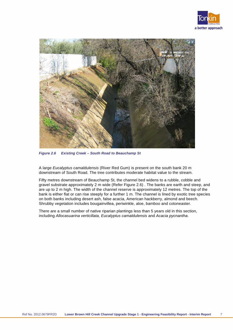
Figure 2.6 Existing Creek – South Road to Beauchamp St
A large Eucalyptus camaldulensis (River Red Gum) is present on the south bank 20 m downstream of South Road. The tree contributes moderate habitat value to the stream.
Fifty metres downstream of Beauchamp St, the channel bed widens to a rubble, cobble and gravel substrate approximately 2 m wide (Refer Figure 2.6) . The banks are earth and steep, and are up to 2 m high. The width of the channel reserve is approximately 12 metres. The top of the bank is either flat or can rise steeply for a further 1 m. The channel is lined by exotic tree species on both banks including desert ash, false acacia, American hackberry, almond and beech. Shrubby vegetation includes bougainvillea, periwinkle, aloe, bamboo and cotoneaster.
There are a small number of native riparian plantings less than 5 years old in this section, including Allocasuarina verticillata, Eucalyptus camaldulensis and Acacia pycnantha.
Ref No. 2012.0679FR2D Lower Brown Hill Creek Channel Upgrade Stage 1 - Engineering Feasibility Report - Interim Report 8
Figure 2.7 Existing Creek - Downstream Beauchamp St.
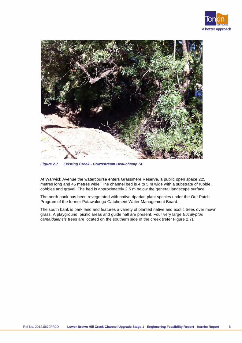
At Warwick Avenue the watercourse enters Grassmere Reserve, a public open space 225 metres long and 45 metres wide. The channel bed is 4 to 5 m wide with a substrate of rubble, cobbles and gravel. The bed is approximately 2.5 m below the general landscape surface.
The north bank has been revegetated with native riparian plant species under the Our Patch Program of the former Patawalonga Catchment Water Management Board.
The south bank is park land and features a variety of planted native and exotic trees over mown grass. A playground, picnic areas and guide hall are present. Four very large Eucalyptus camaldulensis trees are located on the southern side of the creek (refer Figure 2.7).

Ref No. 2012.0679FR2D Lower Brown Hill Creek Channel Upgrade Stage 1 - Engineering Feasibility Report - Interim Report 9
Figure 2.8 Existing Creek – Grassmere Reserve
The channel through the reserve has moderate habitat value. Trees and shrubs provide some shade and contribute organic matter to the channel and the rough channel surface provides some hydraulic diversity. However, there are no pools to provide refuges, no bends to provide hydraulic diversity, no snags or overhanging banks and little in stream vegetation.
Downstream of Daly Street the creek continues for 100 m in a reserve approximately 25 m wide. The south bank is vegetated by mown grass and the north bank abuts the fence of the neighbouring property to the north. The channel bed comprises cobbles and sand and the banks are either earth or reinforced by brick. The top of the banks are vegetated by mature desert ash with a largely bare understorey.
The reserve corridor narrows as the channel turns south through mostly private property. The east bank is bare and extends approximately 6 m from the channel to the rear fence line of private properties and the west bank is positioned directly below rear fence line of private properties. The west bank supports fig, heartleaf iceplant (Aptenia cordifolia) and periwinkle. As the channel turns west, there is a dense overstorey of desert ash, olive and Casuarina cunninghamii with an understorey of ivy.
The channel continues westerly with a 2 to 3 metre wide channel bed comprising cobbles and sand with earth banks that are reinforced in places. The banks are approximately 1.5 m high and the fence is set back from the top of the bank by approximately 1 m. The tops of the banks are vegetated by dense exotic trees that become scattered as the creek approaches Birdwood Terrace.
The creek crosses the Railway Reserve at Birdwood Terrace. Between property frontages (including roads) the park is 55 m wide. The creek crosses the park obliquely over a distance of 85 m. The south bank between the creek and Tilden Ave has been revegetated with local and non-local indigenous species including Eucalyptus camaldulensis, E. leucoxylon, Acacia paradoxa, Dianella revoluta, Cyperus gymnocaulos and Melaleuca nesophylla. Elsewhere the park is vegetated by mown grass and scattered planted trees.

Ref No. 2012.0679FR2D Lower Brown Hill Creek Channel Upgrade Stage 1 - Engineering Feasibility Report - Interim Report 10
Birdwood Terrace to Marion Road
The 350 m section downstream of Birdwood Terrace has a cobble and gravel channel bed. The banks are earth or supported by concrete retaining walls. An Acacia melanoxylon is located on the south bank approximately 50 m downstream of Birdwood Terrace. The tree appears to be less than 10 years old and provides little habitat value. The channel provides no pools or bends and the steep banks support minor riparian vegetation cover. The aquatic weed Cyperus eragrostis is established at the edge of the channel. Tree cover is sparse and dominated by exotic species. There is little or no understorey vegetation on the banks.
Approximately 100 m upstream of Wyatt Street the watercourse becomes a straightened trapezoid concrete channel and provides very poor habitat values. An Acacia pycnantha is located on the south bank at the start of the concrete channel. The tree appears to be less than 10 years old and provides little habitat value.
Marion Road to Keswick Creek
The watercourse from Marion Road to immediately upstream of the confluence with Keswick Creek is entirely a trapezoid concrete channel Figure 2.9). The watercourse provides very poor habitat values. There are no pools to provide aquatic refuges and the smooth channel surface and straight sections provide minimal hydraulic diversity. The concrete lining provides no opportunity for riparian vegetation to establish.
Figure 2.9 Existing Creek - Marion Rd. to Keswick Creek
There is one large river red gum tree located on the north-east bank at the end of Debra Court that potentially provides habitat to native fauna and contributes to riparian values.
The road verge adjacent Debra Court on the north-east bank is approximately 10 m from the channel edge and may provide an opportunity to widen the channel and improve in stream habitat. However an avenue of large, mature tamarix species is planted in this area and would be impacted if the watercourse were widened. The trees have high amenity value that would need to be balanced against habitat improvement by widening the creek.
An undeveloped corridor approximately 30 m wide is available adjacent to Watson Avenue. The area between Watson Avenue and the concrete lined channel is occupied by planted trees over non irrigated, mown grass and a playground. The corridor provides an opportunity to improve in stream habitat.

Ref No. 2012.0679FR2D Lower Brown Hill Creek Channel Upgrade Stage 1 - Engineering Feasibility Report - Interim Report 11
2.5.4 Vegetation
The original vegetation of the channel and banks has been almost entirely lost. The study area would originally have featured a number of increasingly shallow channels and flood-runners (small channels that only carry water during floods) as the creek approached the Reedbeds. Instead the channel has been deepened and straightened to follow a new course. The original watercourses, and its vegetation, have been cut off, cleared and filled. The present channel may be located outside of any original riparian habitat.
The only significant native vegetation habitat values in the study reach are the large river red gum trees. In a natural setting, these trees contribute to the habitat requirements of a range of riparian insects, birds, reptiles and mammals and contribute to the quality of aquatic habitat by providing snags, shade and organic matter. As isolated trees in an urban setting, the river red gums have much less potential to support native fauna. However, they can provide a foundation on which to restore native riparian plant communities through revegetation, such as in the Grassmere Reserve. They also have amenity value.
Most of the vegetation within the creek corridor comprises exotic species which contribute to stream habitat values to some degree by providing shade and organic debris and by providing hydraulic diversity where their roots and stems interrupt the flow of water.
2.5.5 Significant and Regulated Trees
South Australia's significant tree controls came into effect on 20 April 2000 through amendments to the Development Act 1993 and the Development Regulations, followed by the Development (Regulated Trees) Amendment Act 2009 and the Development (Regulated Trees) Variation Regulations 2011.
A “significant” tree is a tree in metropolitan Adelaide, Adelaide Hills Council townships and parts of the Mount Barker Council with a trunk circumference of 3.0 m or more (measured at a point 1.0 m above natural ground level). In the case of trees with multiple trunks, significant trees are those with trunks having a total circumference of 3.0 m or more and an average circumference of 625 mm or more (measured at a point 1.0 m above natural ground level).
A “regulated” tree is as per the same definition, but with a circumference of 2.0m or more.
In total, there are 21 significant trees within the creek reserve or within adjacent property boundaries. 19 of these trees are located east of Birdwood Terrace, and 10 of which are within Grassmere Reserve. The significant trees are located on the following allotments (Table 2.1).
Table 2.1 Significant tree locations within study area
Street / Location Number of
Significant Trees Volume Folio
Creek reserve 2 5542 509
Gray Street 3 5975 152
Grassmere Reserve 10 5542 516
Creek reserve 1 5542 510
Creek reserve 2 2349 35
Tyson Street 1 5642 65
Tyson Street 1 5045 22
Tyson Street 1 5246 472

Ref No. 2012.0679FR2D Lower Brown Hill Creek Channel Upgrade Stage 1 - Engineering Feasibility Report - Interim Report 12
2.5.6 Bridges
There are several existing road and pedestrian bridges crossing the creek within the creek corridor area, including the following locations (downstream to upstream):
Watson Avenue
Harvey Avenue
Marion Road
Birdwood Terrace
Packard Street (pedestrian only)
Daly Street
Gray Street (pedestrian only)
Cross Terrace (pedestrian only)
South Road
Farnham Road
Beauchamp Street (pedestrian only).
The forms of these structures vary from a bridge over a natural creek through to large box culverts.
2.5.7 Services
There are many existing services that cross lower Brown Hill Creek, particularly in the locations of road crossings. The Glenelg to Adelaide Parklands (GAP) Recycled Water Pipeline also runs parallel to the creek section along a portion of the length in Watson Avenue and Galway Avenue.
Particular existing services that could be affected by the works include:
600mm diameter water main in Marion Road
GAP Recycled Water Pipeline adjacent Watson Avenue in road reserves
Optic fibre in road reserves
Trunk sewers in road reserves.
2.6 Access and Circulation
2.6.1 Pedestrian
Several pedestrian bridges provide access across Brown Hill Creek. These bridges are located at Packard Street, Gray Street, Beauchamp Street and Cross Terrace, as depicted in Figure 2.10 to 2.13. These access points are spatially represented in Figure 2.14.
Several road crossings provide access across Brown Hill Creek. These are located at Watson Avenue, Harvey Avenue, Marion Road, Birdwood Terrace, Daly Street, South Road and Farnham Road.

Ref No. 2012.0679FR2D Lower Brown Hill Creek Channel Upgrade Stage 1 - Engineering Feasibility Report - Interim Report 13
Figure 2.10 Packard Street Pedestrian Bridge
Figure 2.11 Gray Street Pedestrian Bridge
Figure 2.12 Beauchamp Street Pedestrian Bridge

Ref No. 2012.0679FR2D Lower Brown Hill Creek Channel Upgrade Stage 1 - Engineering Feasibility Report - Interim Report 14
Figure 2.13 Cross Terrace Pedestrian Bridge
Figure 2.14 Location of Pedestrian Bridges
Bicycle
The area around lower Brown Hill Creek is serviced by a number of on-street bicycle lanes, as well as off-road sealed pathways. The cycling and shared use paths within the City of West Torrens are shown in Figure 2.15. The bicycle routes are described below.

Ref No. 2012.0679FR2D Lower Brown Hill Creek Channel Upgrade Stage 1 - Engineering Feasibility Report - Interim Report 15
Figure 2.15 Bicycle lanes and designated pathways within study area (Source: City of West Torrens)
Captain McKenna Pathway
The Captain McKenna off road sealed pathway provides access between Brown Hill Creek (at Watson Avenue) and the Coast Park pathway. The pathway is also linked to the Reece Jennings Bikeway, which runs parallel to Tapleys Hill Road. Currently, there is no bicycle lane or pathway connection east of Watson Avenue.
Mike Turtur Bikeway
Mike Turtur Bikeway is a shared use path and linear park, which when completed will provide a link between Glenelg and the City. The City of Marion is currently constructing a four kilometre section of the Mike Turtur Bikeway, between Morphett Road and South Road, incorporating public art sculptures and installations.
Westside Bikeway
The Westside Bikeway runs between Glenelg and Mile End, utilising the area previously used for the former Holdfast Bay rail line (identified as a local heritage item in Section 2.10 of this report). The bikeway is a combination of shared use paths and quiet residential streets (refer Figure 2.15).
2.7 Amenity
Much of the length of Lower Brown Hill Creek is hidden from public view behind properties, with residential dwellings that face away from the channel and do not take advantage of the view. This is at least in part due to the poor aesthetics of the creek. As the creek is not in view it is often the target of vandalism and rubbish dumping.

Ref No. 2012.0679FR2D Lower Brown Hill Creek Channel Upgrade Stage 1 - Engineering Feasibility Report - Interim Report 16
2.7.1 Grassmere Reserve
Grassmere Reserve is located between Cross Terrace and Garfield Avenue, Kurralta Park (refer Figure 2.16). The reserve is bisected by Brown Hill Creek. The reserve includes a Guides hall, playground and public seating, as well as a pedestrian footbridge across the creek, providing a linkage between Cross Terrace and Garfield Avenue Figure 2.13). The Reserve is approximately 225 metres in length and 45 metres in width.
Figure 2.16 Grassmere Reserve
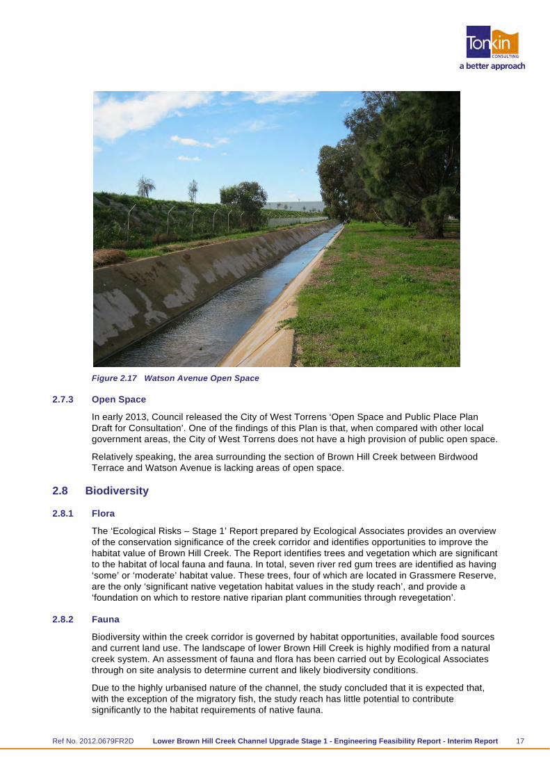
2.7.2 Watson Avenue
Watson Avenue is located at the western end of the study area, adjacent Adelaide Airport. Brown Hill Creek runs alongside Watson Avenue, forming a wide roadside reserve area Figure 2.17). The area is landscaped with trees and some low lying vegetation.
Ref No. 2012.0679FR2D Lower Brown Hill Creek Channel Upgrade Stage 1 - Engineering Feasibility Report - Interim Report 17
Figure 2.17 Watson Avenue Open Space
2.7.3 Open Space
In early 2013, Council released the City of West Torrens ‘Open Space and Public Place Plan Draft for Consultation’. One of the findings of this Plan is that, when compared with other local government areas, the City of West Torrens does not have a high provision of public open space.
Relatively speaking, the area surrounding the section of Brown Hill Creek between Birdwood Terrace and Watson Avenue is lacking areas of open space.
2.8 Biodiversity
2.8.1 Flora
The ‘Ecological Risks – Stage 1’ Report prepared by Ecological Associates provides an overview of the conservation significance of the creek corridor and identifies opportunities to improve the habitat value of Brown Hill Creek. The Report identifies trees and vegetation which are significant to the habitat of local fauna and fauna. In total, seven river red gum trees are identified as having ‘some’ or ‘moderate’ habitat value. These trees, four of which are located in Grassmere Reserve, are the only ‘significant native vegetation habitat values in the study reach’, and provide a ‘foundation on which to restore native riparian plant communities through revegetation’.
2.8.2 Fauna
Biodiversity within the creek corridor is governed by habitat opportunities, available food sources and current land use. The landscape of lower Brown Hill Creek is highly modified from a natural creek system. An assessment of fauna and flora has been carried out by Ecological Associates through on site analysis to determine current and likely biodiversity conditions.
Due to the highly urbanised nature of the channel, the study concluded that it is expected that, with the exception of the migratory fish, the study reach has little potential to contribute significantly to the habitat requirements of native fauna.

Ref No. 2012.0679FR2D Lower Brown Hill Creek Channel Upgrade Stage 1 - Engineering Feasibility Report - Interim Report 18
The fauna investigation identified the potential presence of several fish species in the upper reaches of Brown Hill Creek. Of particular note is the Climbing Galaxias. The fish does not have a conservation rating under South Australia or Commonwealth Legislation but the upper Brown Hill Creek population is thought to be one of only two locations in the Adelaide Hills where it remains.
The Climbing Galaxias is a migratory species and is able to climb vertical in stream structures (e.g. waterfalls or low level weirs) using its fins. The species is considered diadromous - they migrate between freshwater and the ocean to complete their lifecycle. Larvae are swept out to sea where they develop for several months before returning to freshwater in spring as small transparent juveniles (e.g. <4 cm whitebait). However, several landlocked populations exist and may have substituted large lakes for marine habitat.
Ecological Associates report notes the following key points in regard to the Climbing Galaxias:
Historical records show that Climbing Galaxias were last found in Brown Hill Creek in 2005. Monitoring since that time has not detected the species however this does not conclusively establish that the population is extinct.
The importance of migration to the Brown Hill Creek population has not been established and it is possible that although the fish is migratory, the population may live entirely in the upper catchment.
The ability of the fish to migrate may have already been impacted by the poor quality habitat in the lower catchment.
There are several existing sections of Brown Hill Creek that are concrete lined and are poor quality habitats for fish. Other features that are a potential barrier to migration are:
the former gauging station on Brown Hill Creek (just below the Brown Hill Creek caravan Park)
the concrete weir at the confluence of Keswick Creek
the lock system at the mouth of the Patawalonga
the 360m long culvert section in Goodwood installed upstream of the Forestville Reserve to divert Brown Hill Creek as part of the Noarlunga Rail underpass project
Various other culverts.
The study recommends that within the study area, the habitat values of Brown Hill Creek are limited. There are a small number of habitat trees, specifically Eucalyptus camaldulensis. There is an area of riparian revegetation on the right bank of Grassmere Reserve. Sections of the channel have a rocky substrate which contributes to the habitat requirements of fish and invertebrates.
However, the creek provides poor habitat overall. The concrete lined sections do not support any vegetation and have negligible habitat value for aquatic fauna. Riparian vegetation is mostly absent or dominated by exotic species which provide dense shade and limit in-stream primary production. The creek has been straightened and has no significant pools and provides poor hydraulic diversity for fish, frogs and invertebrates.
The impacts on the proposed works on conservation values within the creek corridor are not considered significant.
Habitat values can be promoted on the watercourse where the channel can be widened and a less hydraulically efficient channel is allowable. The three key opportunities are the areas of open space at Grassmere Reserve, Birdwood Terrace and Watson Avenue. Habitat improvement would typically require:
constructing a rocky substrate that provides habitat for aquatic invertebrates and refuges for their resting stages over summer;

Ref No. 2012.0679FR2D Lower Brown Hill Creek Channel Upgrade Stage 1 - Engineering Feasibility Report - Interim Report 19
increasing hydraulic diversity by providing bends, benches, pools, backwaters to provide a variety of habitats for aquatic invertebrates and resting areas for migrating fish;
retaining earth banks, particularly near the top of the bank, to support native riparian sedges and rushes;
increasing plantings of riparian trees and shrubs and removing exotic plant species.
The expected geotechnical conditions particularly bank stability will need to be addressed through design and construction.
2.9 Geotechnical Assessment
A preliminary desktop geotechnical assessment has been completed by Coffey for the lower Brown Hill Creek Channel Upgrade.
Based on a review of the published geotechnical information and previous investigations, the expected subsurface conditions along the lower Brown Hill Creek channel have been assessed to be primarily red brown clay soils. Groundwater is not expected to be encountered in relation to channel works.
The geotechnical assessment provided preliminary advice on the likely subsurface conditions along the channel and provided recommendations relating to the following:
bank stability and erodability
groundwater
channel constructability.
The expected geotechnical conditions particularly bank stability will need to be addressed through design and construction.
2.10 Heritage
2.10.1 Local Heritage
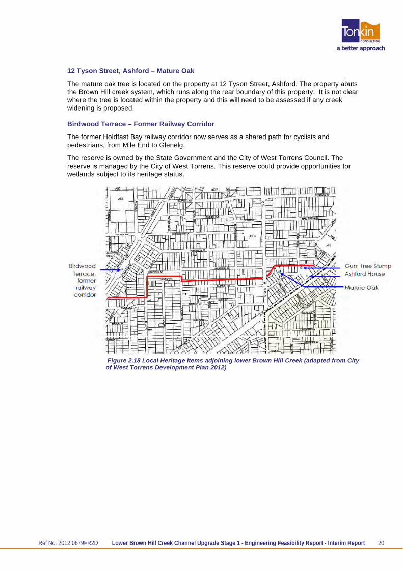
There are four local heritage listed items located on properties immediately abutting the creek. These items include a mature oak tree, Ashford House School and fence, a gum tree stump, and the former railway corridor (Birdwood Terrace). Refer Figure 2.18.
85–87 Anzac Highway, Ashford – Ashford House School and Fence
Ashford House is located at 85–87 Anzac Highway at the eastern end of the study area. The front fence is also included in the listing. The building currently houses Ashford Special School, however the school is due to be relocated at the start of 2014. This may have implications regarding any future redevelopment of the site and the interface with the creek as Brown Hill Creek runs along the rear boundary of the property. The heritage components of this site are unlikely to be affected by any creek upgrade.
85–87 Anzac Highway, Ashford – Gum Tree Stump
This heritage listed gum tree stump is located to the rear of the Ashford Special School (Ashford House) at 85–87 Anzac Highway (refer Figure 2.16). The tree stump is located adjacent to the creek, which runs behind the property. The stump is currently cared for by the West Torrens Historical Society and is contained on its own title with frontage to Farhnam Road. This stump is very close to the creek bank and will need to be considered as part of any creek upgrade.
Ref No. 2012.0679FR2D Lower Brown Hill Creek Channel Upgrade Stage 1 - Engineering Feasibility Report - Interim Report 20
12 Tyson Street, Ashford – Mature Oak
The mature oak tree is located on the property at 12 Tyson Street, Ashford. The property abuts the Brown Hill creek system, which runs along the rear boundary of this property. It is not clear where the tree is located within the property and this will need to be assessed if any creek widening is proposed.
Birdwood Terrace – Former Railway Corridor
The former Holdfast Bay railway corridor now serves as a shared path for cyclists and pedestrians, from Mile End to Glenelg.
The reserve is owned by the State Government and the City of West Torrens Council. The reserve is managed by the City of West Torrens. This reserve could provide opportunities for wetlands subject to its heritage status.
Figure 2.18 Local Heritage Items adjoining lower Brown Hill Creek (adapted from City of West Torrens Development Plan 2012)

Ref No. 2012.0679FR2D Lower Brown Hill Creek Channel Upgrade Stage 1 - Engineering Feasibility Report - Interim Report 21
2.10.2 Aboriginal Heritage
The Aboriginal Heritage desktop study reported that land within 200 metres of a watercourse may contain Aboriginal objects or significant sites. Therefore, any development or construction on land within 200 metres of a watercourse needs to consider the potential for such sites. Although the Department of the Premier and Cabinet-Aboriginal Affairs and Reconciliation Division’s Central Archive ‘has no entries for Aboriginal sites within the project location’, the Department has advised that sites or objects of Aboriginal heritage significance may still exist in the proposed development area.
It should be noted that according to the earliest maps of the Adelaide Plains, Brown Hill Creek – west of Anzac Highway did not exist as a ‘creek’, but rather was part of the floodplain connecting to the wetlands further to the west.
2.11 Environmental Assessment – Site History
Tonkin Consulting completed an environmental assessment as a separate project to identify issues associated with contamination and how this may impact on the upgrade of lower Brown Hill Creek. The results found that greatest potential site contamination is likely to derive from materials used for fill during the construction of the channels which may include hydrocarbons, heavy metals, pesticides and asbestos. The full results are described in the report “Lower Brown Hill Creek Alignment Stage 1 Limited Environmental Site History” (Tonkin Consulting 2012 Reference 20121254).
The potential for removing or treating local contamination has been included in the cost estimates.
Ref No. 2012.0679FR2D Lower Brown Hill Creek Channel Upgrade Stage 1 - Engineering Feasibility Report - Interim Report 22
3 Community Consultation – Key Issues 3.1 Context
An important component of this project is communication and consultation with a range of stakeholders.
A community and stakeholder engagement plan was developed during project inception to guide the communication and consultation activities for the feasibility study. A stakeholders list was developed by the consultant team with input from the Project Steering Committee. The stakeholders covered a range of sectors, namely:
statutory authorities
peak bodies and organisations with an interest in lower Brown Hill Creek
state government departments and representative agencies with an interest in lower Brown Hill Creek
local government
community and user groups located in close proximity to lower Brown Hill Creek.
The key objectives of the communication and consultation strategy were to:
inform stakeholders of the project’s rationale, potential benefits and constraints;
provide opportunities for stakeholders to identify issues or opportunities for the project;
ensure all identified stakeholders are well informed about the process used to develop a broad concept.
The key communication and consultation methods during the feasibility study were:
City of West Torrens newsletter article (Messenger) – outlining the project objectives and ‘watch this space’ for opportunities for residents and property owners to contribute their views and find out more about the project.
Introductory letter to property owners/occupiers – Letter to all property owners and occupiers adjacent the creek section outlining the project objectives and opportunities to contribute their views.
Fact sheet – distributed to all those agencies and groups on the stakeholders list, including all property owners and occupiers. The fact sheet outlined the project aims, what the feasibility would explore and how stakeholder views and technical investigations would be used to prepare a concept option/s for the channel.
Stakeholder workshop – to outline the key technical investigation and project constraints and opportunities and gain feedback from stakeholders about the project objectives. The workshop also outlined the next steps for the project.
Community information displays – Two community information displays were held on Saturday mornings at shopping centres in close proximity to the creek channel. The information displays were held to inform the community about the project and the potential options for the channel upgrade, as well as seeking feedback and ideas. Names were also collected for a mailing list for future project information mail-outs.
Council website – up-to-date, general information maintained by Council.
A collation of the key consultation findings drawn from the stakeholder workshop and community information display are outlined below.

Ref No. 2012.0679FR2D Lower Brown Hill Creek Channel Upgrade Stage 1 - Engineering Feasibility Report - Interim Report 23
3.2 Key Issues and Opportunities
The consultation findings can be clustered into a series of themes:
Stormwater Management
Many stakeholders believe that the management of flood waters and reducing property flooding is the main focus of the project.
Water Quality and Reuse
A number of stakeholders felt that the project provides an opportunity to improve water quality in the catchment. However, it was understood that a ‘whole of catchment’ approach needs to be undertaken to improve water quality in the catchment, and any works undertaken in the creek as an end of line solution can not improve water quality significantly across the catchment.
Integrity of Grassmere Reserve
It was important to many of the participants that the integrity (i.e. landscape and amenity characteristics) of Grassmere Reserve be retained. There was concern about the potential loss of the existing trees in Grassmere Reserve as one of the only existing areas of open space amenity included in the creek section.
A lack of open space in adjoining areas was also identified, with a strong desire to retain the open space in Grassmere Reserve and increase open space elsewhere where possible.
Play and Interpretation
Stakeholders were enthusiastic about the opportunities for creating ‘natural’ play elements into the design of the creek section and improve accessibility. Returning to a more natural system with access to water for play and observation purposes was seen to be beneficial, however the need to balance this with economic cost and property acquisition requirements was also realised.
There was also a desire to see historical and community education elements of the creek section to be incorporated, i.e. interpretative signage.
Recreation Uses
Several stakeholders identified that the creek upgrade project had the opportunity to provide increased recreational uses, in particular a shared path or bike track. However, the channel corridor does not fit with the SA Government bike strategy, Bike SA have no plans for a bike path in the area and consider the area well served by other paths.
Biodiversity
Many stakeholders considered the current biodiversity of the channel poor and something that could be improved by the project works. However, there was the need to balance biodiversity outcomes with economic, safety and community benefit.
Grassmere Reserve was seen as an opportunity to provide a more natural creek habitat and encourage biodiversity in the area.
Accessibility
A number of stakeholders identified Brown Hill Creek as a natural barrier within the West Torrens area. Additional access across, along and to the creek was supported.
Property Acquisition
Most stakeholders and the community did not want to see excessive property acquisition and for people to be relocated as part of the project.

Ref No. 2012.0679FR2D Lower Brown Hill Creek Channel Upgrade Stage 1 - Engineering Feasibility Report - Interim Report 24
Desired Landscape Characteristics
Several participants believed that the project provided opportunities to improve the amenity of the area, including creek enhancement.
Some of the other key desired landscape characteristics include:
preservation of native vegetation and significant trees
increase the biodiversity of the area
minimisation of the use of hard infrastructure to areas
maximisation of the characteristics to achieve broader stormwater management outcomes.
3.3 Overall Most Desired Elements
The most desired elements for the project identified from the stakeholder interviews and workshop include:
Flood mitigation – this must be the main focus of the project
Water quality – improve water quality where possible
Open space – retain Grassmere Reserve
Biodiversity – increase the biodiversity in the channel section
Recreation – enhance opportunities for recreation (shared path)
Accessibility – provide access to the area and connectivity across the creek.

Ref No. 2012.0679FR2D Lower Brown Hill Creek Channel Upgrade Stage 1 - Engineering Feasibility Report - Interim Report 25
4 Project Opportunities The key objective for the project is flood mitigation, i.e. upgrading the channel section so that its capacity can accommodate a 60m3/s peak design flow.
Several other project objectives and principals have been developed as outcomes of stakeholder consultation and from development and consideration of the subject area which are elements to be explored and developed through the future design stages. The following principles have been developed for the project:
To preserve existing significant trees
To improve biodiversity
To increase amenity
To provide recreation benefit
To minimise the use of hard infrastructure
To minimise the footprint extent of works and impact on private property
Improved pathways and connectivity for public and maintenance access
Public access to channel.
Although these objectives can be conflicting, there is still merit in considering them while evaluating the options presented in this study.
4.1 Significant Trees
As previously discussed, 21 significant trees have been identified within or adjacent to the lower Brown Hill Creek corridor. Preserving these trees whilst undergoing a major creek upgrade will be a difficult process due to the likely extent of earthworks required. However it is intended that the upgrade will slow the erosion of the creek banks which is threatening the stability of some trees. Impact on the trees will be determined at concept design stage once the trees are accurately located and concepts developed. River red gums have a high tolerance to root disturbance which may allow creek bank modifications without long term damage to the tree.
4.2 Biodiversity
The existing biodiversity in the creek corridor is very limited due to a lack of appropriate habitats, the highly urbanised environment and presence of exotic species. However this project does present the opportunity to provide some more suitable habitat areas either throughout the length of the channel by replacing the existing concrete sections, or at localised Water Sensitive Urban Design (WSUD) features such as wetlands or detention basins (e.g. potential for a wetland at the railway corridor).
4.3 Amenity
The amenity of the creek within the study area is varied with some vegetated sections considered to be quite appealing. The sections of engineered concrete channels are widely considered to be an eyesore, particularly in areas where they are targeted by graffiti vandals or have rubbish dumped. Therefore another objective of the project is to improve the overall appearance of the creek through either the main channel upgrade itself or landscaping around the main channel. Encouraging redevelopment of dwellings to face the creek may reduce vandalism and increase the sense of ownership in the community.

Ref No. 2012.0679FR2D Lower Brown Hill Creek Channel Upgrade Stage 1 - Engineering Feasibility Report - Interim Report 26
4.4 Recreation
Currently the channel within the creek corridor has limited recreation value, with the exception of Grassmere Reserve where the creek is a substantial feature of the open space. Although the ephemeral nature of the creek limits the type of activities that can be enjoyed in the creek, there is still scope to allow more passive recreation activities in and around the creek.
4.5 Minimise Hard Infrastructure
The community generally has an unfavourable view towards what is referred to as “hard” engineered infrastructure, which can be described as structures that do not blend well with their surroundings. In the context of this study, this is likely to refer to open concrete channels. Should the use of hard infrastructure be unavoidable, incorporating WSUD features such as wetlands at the railway corridor should be investigated together with other landscape features.
4.6 Minimise Footprint
One objective that may be contradictory to the others discussed is to minimise the footprint of the upgrade in order to reduce the impact on private property. Upgrade solutions that are sensitive to the environment and increase the recreation value of the channel are generally those that require a greater width (and hence footprint) in order to convey the design flow. However residents who would be directly affected by property acquisition may consider minimising the footprint to be of the highest priority.
4.7 Improved Connectivity
There is an opportunity to use the creek alignment as a transport corridor for pedestrians and cyclists to provide recreational access and provide more links to regional cycle paths. Access along and across the creek will improve connectivity between adjoining suburbs.
Providing a maintenance track which can also be used for pedestrians and cyclists could be another feature to be incorporated into the final design.
If the creek was fully enclosed, access within the creek corridor above the culvert could be provided
4.8 Public Access
Public access to the channel is currently limited as many sections are either fenced off or have steep banks. Access is available at Grassmere Reserve and at the existing pedestrian bridges. The advantages of public access must also be balanced with the risk to public safety during flood events. Improving access to the creek with informative signage will provide a community education benefit.

Ref No. 2012.0679FR2D Lower Brown Hill Creek Channel Upgrade Stage 1 - Engineering Feasibility Report - Interim Report 27
5 Channel Upgrade 5.1 Introduction
This section summarises the key results from the investigation of options for the channel cross sections within lower Brown Hill Creek. The cross sections are not site specific and it is expected that a number of different cross sections will be selected for the final solution. The options presented are at a preliminary concept level and it is expected that further refinement and selection of these concepts will occur during future design stages of the project.
5.2 Design Criteria
5.2.1 Stormwater Management Plan
In relation to flood mitigation, the key performance outcome of the design is outlined as follows:
Proposed/desired channel capacity is 60m3/s based on the 100 year ARI event
This channel capacity requirement is described in the 2012 Stormwater Management Plan. It includes:
The proposed diversion of approximately 25 m3/s of peak flow from Keswick Creek into Brown Hill Creek at Anzac Highway
Flows from upper Brown Hill Creek (upstream of Anzac Highway
Relatively small inflows from the local catchment along Lower Brown Hill Creek.
5.3 Cross Section options
Cross section options for the channel section have been developed based on the required channel capacity and including secondary objectives such as water quality improvement, biodiversity, amenity, recreation and environmental improvement. The specifics of these options are flexible, however the overall concept of each cross section is outlined below.
It is likely that the final solution will be a combination of options, designed to suit each particular section of the creek.
Ref No. 2012.0679FR2D Lower Brown Hill Creek Channel Upgrade Stage 1 - Engineering Feasibility Report - Interim Report 28
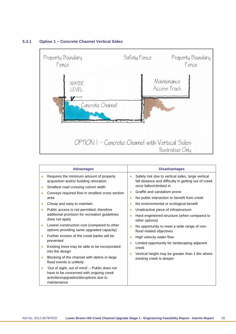
5.3.1 Option 1 – Concrete Channel Vertical Sides
Advantages Disadvantages
Requires the minimum amount of property acquisition and/or building relocation
Smallest road crossing culvert width
Conveys required flow in smallest cross section area
Cheap and easy to maintain
Public access is not permitted, therefore additional provision for recreation guidelines does not apply
Lowest construction cost (compared to other options providing same upgraded capacity)
Further erosion of the creek banks will be prevented
Existing trees may be able to be incorporated into the design
Blocking of the channel with debris in large flood events is unlikely
‘Out of sight, out of mind’ – Public does not have to be concerned with ongoing creek activities/upgrades/disruptions due to maintenance
Safety risk due to vertical sides, large vertical fall distance and difficulty in getting out of creek once fallen/climbed in
Graffiti and vandalism prone
No public interaction or benefit from creek
No environmental or ecological benefit
Unattractive piece of infrastructure
Hard engineered structure (when compared to other options)
No opportunity to meet a wide range of non-flood related objectives
High velocity water flow
Limited opportunity for landscaping adjacent creek
Vertical height may be greater than 1.8m where existing creek is deeper
Ref No. 2012.0679FR2D Lower Brown Hill Creek Channel Upgrade Stage 1 - Engineering Feasibility Report - Interim Report 29
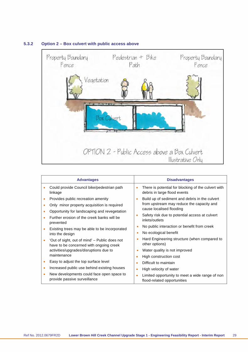
5.3.2 Option 2 – Box culvert with public access above
Advantages Disadvantages
Could provide Council bike/pedestrian path linkage
Provides public recreation amenity
Only minor property acquisition is required
Opportunity for landscaping and revegetation
Further erosion of the creek banks will be prevented
Existing trees may be able to be incorporated into the design
‘Out of sight, out of mind’ – Public does not have to be concerned with ongoing creek activities/upgrades/disruptions due to maintenance
Easy to adjust the top surface level
Increased public use behind existing houses
New developments could face open space to provide passive surveillance
There is potential for blocking of the culvert with debris in large flood events
Build up of sediment and debris in the culvert from upstream may reduce the capacity and cause localised flooding
Safety risk due to potential access at culvert inlets/outlets
No public interaction or benefit from creek
No ecological benefit
Hard Engineering structure (when compared to other options)
Water quality is not improved
High construction cost
Difficult to maintain
High velocity of water
Limited opportunity to meet a wide range of non flood-related opportunities
Ref No. 2012.0679FR2D Lower Brown Hill Creek Channel Upgrade Stage 1 - Engineering Feasibility Report - Interim Report 30
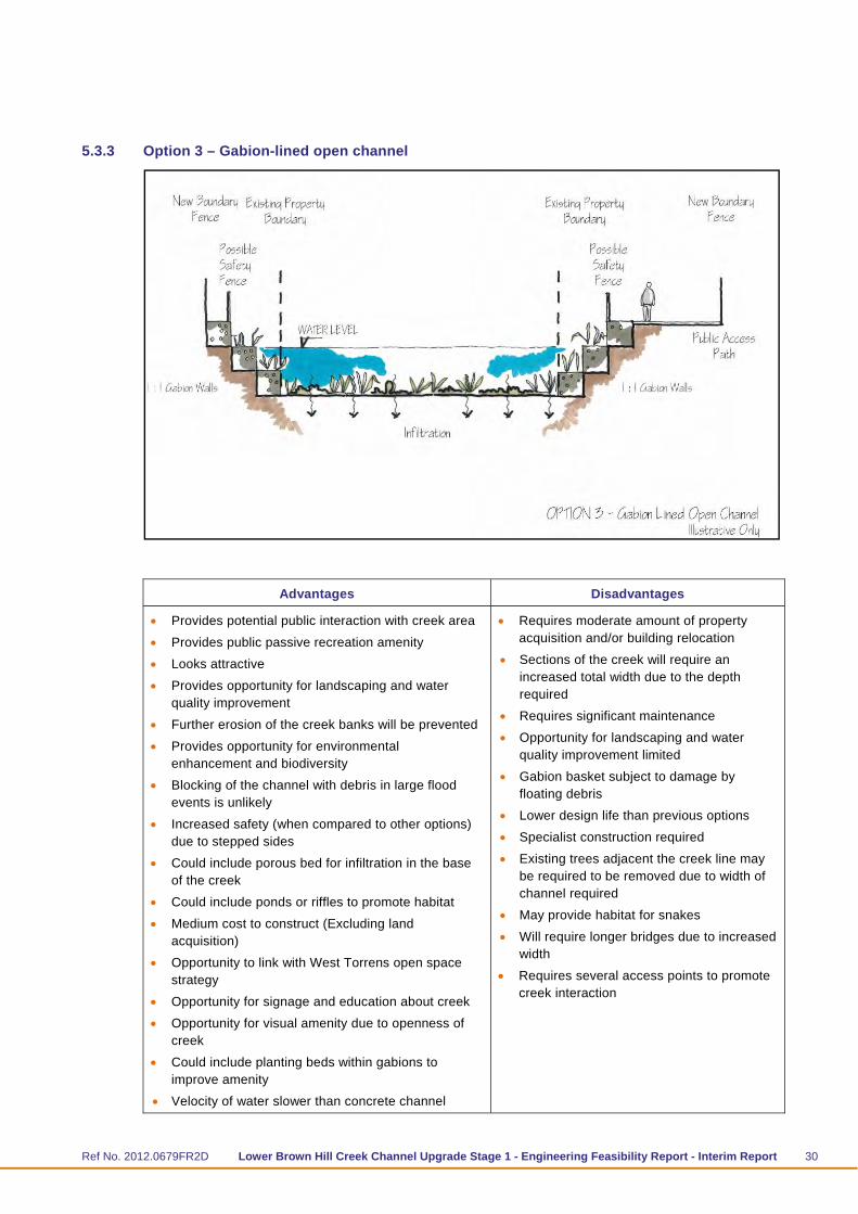
5.3.3 Option 3 – Gabion-lined open channel
Advantages Disadvantages
Provides potential public interaction with creek area
Provides public passive recreation amenity
Looks attractive
Provides opportunity for landscaping and water quality improvement
Further erosion of the creek banks will be prevented
Provides opportunity for environmental enhancement and biodiversity
Blocking of the channel with debris in large flood events is unlikely
Increased safety (when compared to other options) due to stepped sides
Could include porous bed for infiltration in the base of the creek
Could include ponds or riffles to promote habitat
Medium cost to construct (Excluding land acquisition)
Opportunity to link with West Torrens open space strategy
Opportunity for signage and education about creek
Opportunity for visual amenity due to openness of creek
Could include planting beds within gabions to improve amenity
Velocity of water slower than concrete channel
Requires moderate amount of property acquisition and/or building relocation
Sections of the creek will require an increased total width due to the depth required
Requires significant maintenance
Opportunity for landscaping and water quality improvement limited
Gabion basket subject to damage by floating debris
Lower design life than previous options
Specialist construction required
Existing trees adjacent the creek line may be required to be removed due to width of channel required
May provide habitat for snakes
Will require longer bridges due to increased width
Requires several access points to promote creek interaction

Ref No. 2012.0679FR2D Lower Brown Hill Creek Channel Upgrade Stage 1 - Engineering Feasibility Report - Interim Report 31
5.3.4 Option 4 – Earth Channel
Advantages Disadvantages
Provides potential public interaction with creek area
Provides public passive recreation amenity
Looks attractive
Provides opportunity for landscaping and water quality improvement
Provides opportunity for environmental enhancement and biodiversity
Provides habitat for local fauna
Blocking of the channel with debris in large flood events is unlikely
Increased safety (when compared to other options) due to moderate side slopes
Softer engineered structure
Could include porous bed for infiltration in the base of the creek
Medium cost to construct (Excluding land acquisition)
Opportunity to link with West Torrens open space strategy
Opportunity for signage and education about creek
Opportunity for visual amenity due to openness of creek
Lower flow velocity
Could provide pools and riffles for habitat
Requires significant amount of property acquisition and/or building relocation
Requires large cross section area that may be better utilised with a different land use
Requires significant maintenance
Erosion of creek floor and banks may occur
Lower design life than previous options
Standing water may promote mosquito breeding
Requires longer width of bridges/culverts due to large total cross section width
Existing trees adjacent the creek line may be required to be removed due to width of channel required
May provide habitat for snakes
Sections of the creek will require an increased total width due to the depth required

Ref No. 2012.0679FR2D Lower Brown Hill Creek Channel Upgrade Stage 1 - Engineering Feasibility Report - Interim Report 32
5.3.5 Option 5 – Low Flow Channel overtopping box culvert
Advantages Disadvantages
Provides public access
Provides public passive recreation amenity
Only minor property acquisition is required
Some opportunity for landscaping and revegetation
Further erosion of the creek banks will be prevented
Existing trees may be able to be incorporated into the design
Low flow channel will provide environmental and habitat value
Provides public interaction with creek
Provides ‘dual flowpath’ during large flood events
Opportunity to improve water quality
New developments could face open space to provide passive surveillance
Could reduce size of underground culvert and encourage surface flow in major events
Open channel could provide habitat
There is potential for blocking of the culvert with debris in large flood events
Build up of sediment and debris in the culvert from upstream may reduce the capacity and cause localised flooding
Safety risk due to potential access at culvert inlets/outlets
Higher construction cost compared to other options
Steeper sites or a deeper creek may require increased total width
Low flow channel above the culvert may require water to be pumped from the culvert.
Low flow channel will require additional maintenance.
5.3.6 Other Options
Other options are described below:

Ref No. 2012.0679FR2D Lower Brown Hill Creek Channel Upgrade Stage 1 - Engineering Feasibility Report - Interim Report 33
Cross sections similar to or a combination of existing options have not been investigated. The cross sections selected were based on an initial workshop to achieve the 60 m3/s design flow and consider cost, environmental and social factors. Some refinement of sections will be necessary during the concept design phase. This may include changing batter slopes on open channels, a concrete trapezoid channel in place of a concrete vertical walled channel if space is available or a combined gabion and open channel (i.e. 1 metre gabion and battered slopes above).
A culvert underlying an open space floodway has been investigated in detail (refer Tonkin Consulting report 20120679FR3 – October 2013) and was found to have insufficient capacity for a 60m3/s peak flow but may be viable at a lower required capacity.
A bypass culvert running generally parallel to the creek in the road network has been investigated in more detail (refer Tonkin Consulting report 20120679-FR1C – October 2013). This was found to have insufficient capacity for a 60 m3/s peak flow although may be viable at a lower required capacity.
Minor diversions along the alignment to avoid land acquisitions or improve the hydraulics. An example of this is the area in the vicinity of Daly Street to McArthur Avenue in which the creek is mostly within private property and has two near right angle bends. For the feasibility stage, this has not been investigated in detail.
5.4 Hydraulic Modelling
Approximate channel sizes of the various channel geometry options were determined using hydraulic modelling.
A 1-D hydraulic model of lower Brown Hill Creek has been created utilising the HEC-RAS computer backwater curve model for the open channel options. Data from the AWE Creek Hydraulic Capacity Report (2012) was used to define the existing channel geometry and characteristics. The model was executed for a 60m3/s flow for various cross sections to assess the type and size of cross section required, channel capacities and locations where exceedance is predicted to occur.
The model was also run for the 1 year ARI flow of 16m3/s and the 1 year ARI flow if Keswick Creek is not diverted to Brown Hill Creek of 9m3/s in order to confirm that the channel velocity does not cause erosion or deposition.
The culvert options were assessed and modelled using a Hydraulic Grade Line (HGL) analysis. In both cases the creek invert was adjusted slightly to improve the capacity. A preliminary assessment of under services confirmed that lowering the channel invert was possible in some areas.
The required velocities are as follows:
Maximum velocities to prevent erosion:
Concrete: 6m/s
Gabions: 5m/s
Rock Lined Channel: 1.5-4 m/s
Vegetated unlined channel: 1.5 m/s.
Minimum velocity to prevent siltation: 0.6 m/s.

Ref No. 2012.0679FR2D Lower Brown Hill Creek Channel Upgrade Stage 1 - Engineering Feasibility Report - Interim Report 34
HGLs of the vertical sided channel, gabion-lined channel, trapezoidal channel and box culvert are provided in Appendix B.
The required size for different cross section options for the channel is shown in Table 5.1.
Based on the findings of the hydraulic modelling of the cross section options (refer Table 5.1), it is considered feasible to achieve a 100 year ARI capacity of the lower Brown Hill Creek Channel of 60 m3/s, subject to upgrade works being undertaken to increase the current channel capacity.
The modelling completed is conceptual and has not been fully refined. It is expected that detailed design will include further modelling that will incorporate site specific constraints (i.e. road crossings, existing service crossings, etc). Scour velocities, impact on the creek due to changes in velocities (between different cross sections) and any water quality treatments proposed would also be considered during development of a concept design.

Ref No. 2012.0679FR2D Lower Brown Hill Creek Channel Upgrade Stage 1 - Engineering Feasibility Report - Interim Report 35
Table 5.1 Channel upgrade options summary
Option Cross-Section
Geometry Geometry Manning's 'n'
Design Flow (m3/s)
Average Flow Top Width (m)
Max Velocity
(m/s)
Average Velocity
(m/s) Comments*
1 Rectangular
Open Channel
7m width, 2.1m depth
0.013 (concrete) 60 7.0 6.5 5.6 Approx 600m of channel increased to 7.5m width. 16 7.0 4.2 3.5
9 7.0 3.5 2.9
2 Culvert 9m width x 1.8m height
0.013 60 9 3.7 3.7 Primed culvert
16 9 4.8 3.5 Open Channel Flow in culvert
9 9 3.9 2.8 Open Channel Flow in culvert
3 Gabion –lined open channel
10m base width, 1m stepped gabion sides to 2m
0.035 60 16.6 5.2 2.4 Approx 1600m length with 12m base width, 16 11.4 4.0 1.7
9 11.0 3.5 1.4
4 Trapezoidal
Earth-lined channel (Natural Channel)
6m base width, 1:4 side slopes, 2.1m depth
0.035 base (small rocks), 0.05 sides (vegetated)
60 24.9 4.0 3.2 Some sections base width increased to 8m 16 14.2 2.7 2.1
9 12.0 2.3 1.7
*The existing structures within the creek have not been modelled in detail and for the purposes of this feasibility have been assumed that if they have insufficient capacity they will be upgraded to suit the required capacity.

Ref No. 2012.0679FR2D Lower Brown Hill Creek Channel Upgrade Stage 1 - Engineering Feasibility Report - Interim Report 36
6 Constructability and Opinion of Cost 6.1 Construction Cost
Leed Engineering and Construction Pty Ltd (Leed), as a sub-consultant to Tonkin Consulting, completed a constructability and concept pricing report of the cross section options for the lower Brown Hill Creek Channel Upgrade. This was a high level report to provide input for the construction issues anticipated for the various proposed options, and to provide indicative comparison pricing.
The report is summarised as follows:
Cross Section options were requested to be evaluated as discussed below
Leed completed the report based on a review of site observations and information supplied by Tonkin Consulting
Extent of works is over the full length of Lower Brown Hill Creek from the downstream side of Anzac Highway to immediately upstream of the confluence of Keswick Creek. Some road crossings which are likely to have sufficient capacity based on visual assessment have been retained.
The cost estimates have been supplied as a linear metre pricing for each option and consider supply of materials, construction, landscaping, design growth, construction management, contractor’s risk, design costs and client contingencies
The linear metre pricing for each option has been calculated and is given in Table 6.1. This cost per linear meter excludes road and pedestrian structures, service relocations and land acquisitions. There is approximately 3,135 linear metes of creek works and 165 metres of road culverts. The Leed costs include 35% contingency.
The cost for road culverts, pedestrian bridges, design and an allowance for service relocations has been estimated at $10.3 M including 35% contingency. This cost would be similar for each option. The linear metre rate for the culverts under roads (road crossings) is $35,700 per linear metre including the 35% contingency.
The total construction cost includes the linear metre rate x 3,135 linear metres plus a lump sum cost (similar for all options) of $10.3M for road crossings, pedestrian bridges design and service relocations
All costs exclude GST.
Table 6.1 Linear metre construction pricing summary excluding land acquisition
No.
Option
Cross section width (m)
Linear metre cost
($/m) excluding
bridges and service
relocations
Total channel cost ($M) including
bridges and service
relocations
1 Vertical Sided Open Channel 12 $15,800 $59.8
2 Box Culvert with Shared Path 12 $22,800 $81.8
3 Stepped Gabion Channel 21 $21,000# $76.0
4 Trapezoidal unlined channel (Natural Channel)
30 $6,900# $31.8
5 Box Culvert and low flow channel 12 $24,900 $88.2 # Requires significant land acquisition (not included in cost).

Ref No. 2012.0679FR2D Lower Brown Hill Creek Channel Upgrade Stage 1 - Engineering Feasibility Report - Interim Report 37
6.2 Constructability
Leed undertook an assessment of the constructability issues which has informed the opinion of cost.
A number of significant construction issues have been identified for those options contained within the creek corridor. These include:
Community consultation / notification
Management of base flow. Works to be restricted to the summer period
Management of flood flow
Stability of executions and shoring
Access to the creek and along the creek. Material and surplus spoil may need to be tracked along the creek to a suitable access point
Location of a suitable compound (potentially in the rail corridor)
Dilapidation surveys and impact on adjoining properties
Protection of trees and vegetation
Management of any contaminated material (should it be identified).
Whilst the work is difficult it is likely to be achievable albeit at a higher cost.
The works would most likely be completed in sections over a number of years (summer construction periods) except where diversions are being constructed.
6.3 Property Acquisition
Maloney Field Services completed a Preliminary Land Acquisition Report for the lower Brown Hill Creek Channel Upgrade.
The report is summarised as follows:
Properties were identified by the City of West Torrens in which some or all of the creek alignment existed in private property.
29 properties were identified including ten strata units within three separate strata schemes.
A review of aerial photography, site inspection (from the road) and title search identified where properties may require only partial acquisition, based on Council acquiring the entirety of the current creek alignment as freehold.
A unit rate for full and partial acquisition including all costs incurred in obtaining the property but not including residual costs has been calculated based on the acquisition costs of the identified properties as follows:
Partial Acquisitions – $1,200 per m2
Full Acquisitions – $900 per m2
The unit rate has been applied by Tonkin across the different channel cross section options as shown in the following figures. The total property acquisition costs for each option are given in Table 6.2.
To reduce or avoid land acquisitions in the vicinity of Daly Street to McArthur Avenue, it may be possible to divert Brown Hill Creek within the road network (i.e. along Garfield Avenue) towards the disused rail reserve and then rejoin Brown Hill Creek downstream of the rail reserve. This has not been investigated in detail or an estimate of cost prepared.
Ref No. 2012.0679FR2D Lower Brown Hill Creek Channel Upgrade Stage 1 - Engineering Feasibility Report - Interim Report 38
Table 6.2 Property acquisition cost summary
No. Option
Cross section width (m)
Total Area Required
(over length of creek)
(m2)
Total Property Acquisition
Area Required (m2)
Property Acquisition
Cost ($ Million)
Property Acquisition
Cost ($/linear metre of
channel)*
1 Vertical Sided Open Channel
12 39,600 5,982 $7.4 $2,242
2 Box Culvert with Shared Path
12 39,600 5,982 $7.4 $2,242
3 Stepped Gabion Channel
21 69,300 35,683 $34.1 $10,333
4 Open Swale (Natural Channel)
30 99,000 65,382 $60.8 $18,424
5 Box Culvert and low flow channel
12 39,600 5,982 $7.4 $2,242
* Property acquisition cost distributed over the entire 3300 m channel length (for construction cost comparison
purposes).
The costing in the table above is based on the land acquisition cost reporting by Maloney Field Services. The numbers in the table above do not include residual value and have made assumptions as per the reporting as to full and partial acquisitions required. However, this could be overestimated if some of the properties identified as having the creek alignment in their ownership actually do not. This should be confirmed with site survey.
A ‘best case’ scenario costing for property acquisition for options 1, 2 and 5 assuming that the acquisition of ambiguous adjoining properties is not required and including gains from residual value is provided below:
Best case scenario property acquisition cost = $2.6 million
This cost could be best applied to the options that do not require additional creek alignment width. This could be reduced further if easements were acquired although this is not a preferred arrangement.
6.4 Total Construction cost including Land Acquisition
The total construction cost including land acquisitions is shown in Table 6.3. This is based on the 2012 SMP flow rates.

Ref No. 2012.0679FR2D Lower Brown Hill Creek Channel Upgrade Stage 1 - Engineering Feasibility Report - Interim Report 39
Table 6.3 Total Cost Including Land Acquisition – 60 m3/s peak flow
No. Option Typical Cross-Section
Construction Cost *
Total Construction
Cost*
Property Acquisition
Cost*
Grand Total including
Construction and Land
Acquisition*
($ / m) $ Million $ Million $ Million
1 Vertical Sided Open Channel
$15,800 $59.8 $7.4 $67.2
2 Box Culvert with Shared Path
$22,800 $81.8 $7.4 $89.2
3 Stepped Gabion Channel
$21,000# $76.0 $34.1 $110.1
4 Open Swale (Natural Channel)
$6,900# $31.8 $60.8 $92.6
5 Box Culvert and low flow channel
$24,900 $88.2 $7.4 $95.6
#All costs exclude GST

Ref No. 2012.0679FR2D Lower Brown Hill Creek Channel Upgrade Stage 1 - Engineering Feasibility Report - Interim Report 40
7 Multi-Criteria Analysis A multi-criteria analysis (MCA) is a process for a wider project team to evaluate a number of options through the use of weighted performance criteria and a common scoring system. For this project a MCA process has been used to evaluate the various channel options and to score these options by taking into account a range of project objectives.
The MCA workshop for this project was held on 9 May 2013 and included the following attendees:
Name Organisation
Angelo Catinari City of West Torrens
Andrew King City of West Torrens
Michael Salkeld BHKC Project
John Larwood BHKC Project
Michael de Heus Tonkin Consulting
Jo O’Brien Tonkin Consulting
Ken Schalk Tonkin Consulting
Kylie Fergusen Jensen Planning + Design
Lisel Ashby Jensen Planning + Design
The key discussion points of the workshop are described below:
Scoring and weighting was discussed and agreed.
Each channel option was scored by the workshop attendees as a group, and a final score was agreed upon for each option.
An analysis of the score and ranking was also completed without the cost component for comparison.
A sensitivity analysis was undertaken in the workshop to assess the cost and ranking sensitivity.
A ranking hierarchy of preferred options is the outcome of the scoring, which will inform the next stage of development; assessing the cross section options with reference to different creek section areas.
The agreed MCA criteria and weighting included
Environment = 20%
Social and community benefit = 30%
Construction and Operations = 50%.
The options considered in the MCA were:
Concrete Lined, Vertical Sided Open Channel
Box culvert overtopped with public access
Gabion lined open channel
Natural channel
Box culvert overtopped with low flow channel

Ref No. 2012.0679FR2D Lower Brown Hill Creek Channel Upgrade Stage 1 - Engineering Feasibility Report - Interim Report 41
The options of the bypass culvert (culvert in the road network) and the culvert underlaying an open space flow flow path were not considered as they did not have sufficient capacity for the 60 m3/s peak flow.
Figure 7.1 shows the agreed criteria, sub-criteria and ranking together with a description of the sub-criteria.
This weighting were thought to reflect a balance of project objectives, considering that the key objective, flood mitigation, is not considered in the MCA as this is a non-negotiable.
Some of the sub-criteria have scored the same number in different options for separate reasons. For example, the ‘Improved visual amenity’ sub-criteria score of 3 has been given for the Gabion channel and the Box culvert with public access. These options were both assessed to have a visual amenity improvement score of 3. They look very different visually, however their improvement value has been assessed as equal.
Figure 7.1 Lower Brown Hill Creek Upgrade Options – MCA Workshop
7.1 Total Score and Ranking Outcome from MCA Workshop
The total score and rank of each option as concluded in the MCA workshop is given in Table 7.1. The complete spreadsheet is given in Appendix D.
Table 7.1 MCA Workshop Summary
Concrete Lined, Vertical
Sided Open Channel
Box culvert overtopped with
public access
Gabion lined open channel
Natural channel
Box culvert overtopped
with low flow channel
Total Weighted Score / 100
47.0 55.9 48.9 59.1 56.3
Rank 5 3 4 1 2

Ref No. 2012.0679FR2D Lower Brown Hill Creek Channel Upgrade Stage 1 - Engineering Feasibility Report - Interim Report 42
7.2 Discussion
The highest ranking option was the natural channel due to the strong environmental benefits, and the comparable social and community benefits. Its cost scored lower than other options but not significantly as the option’s low construction cost was offset by its high land acquisition cost and high construction disruption (i.e. property acquisition). In this case the MCA rating for impact on adjoining residents was not significant enough to change its rank.
Based on the MCA, and the closeness of the final results, each option is still considered worthwhile investigating further as a component of the overall creek upgrade.

Ref No. 2012.0679FR2D Lower Brown Hill Creek Channel Upgrade Stage 1 - Engineering Feasibility Report - Interim Report 43
8 Project Opportunities and Alternatives Since the beginning of this study a number of issues have been discussed within the wider project team in relation to changes to the design inputs and different options for the creek alignment and cross sectional geometry.
8.1 Hydrology
The original scope of the investigation was to investigate options suitable to convey a 60m3/s peak flow along the existing channel alignment as described in the 2012 Stormwater Management Plan. Since the initial hydraulic modelling was completed, the hydrology requirements have been discussed during steering committee meetings with respect to whether the design flows can be reduced based on:
construction of a dam in the upper catchment; and/or
whether the predicted inflows have been over-estimated (no allowance for storage within the catchment). The extent of over estimation has been estimated by DPTI (Bill Lipp) through sub-catchment analysis to be in the order of 20%; and /or
changes to the design IFD (Intensity Frequency Duration) curves as part of 2013 upgrades to Australian Rainfall and Runoff.
A comparison of 1:100 year ARI design flow is summarised in Table 8.1.
Table 8.1 1:100 yr ARI flow (m3/s) in Brown Hill Creek immediately downstream of Anzac Highway -
Lower Brown Hill Creek
2012 (no dam)* 2012 (with dam)*
2013 (no dam)* 2013 (with dam)*#
Anzac Hwy (u/s) 38.9 (36 hr) 33.9 31 (36 hr) 26.8
Diversion flow from Keswick Creek
25 25 22.5 22.5
Anzac Hwy (d/s) 56.6 56.6 44.1 44.1
D/s junction with Keswick Creek
58.6 58.6 45.9 45.9
* All peak flows are governed by 90 minute storm except where indicated
# BHC peak flows from upstream of Anzac Highway would be reduced (mainly for the 36 hour storm) if there were to be
a flood control dam in the rural part of the catchment
8.2 Keswick Bypass Alignment (West Torrens)
In conjunction with this study, The City of West Torrens requested an investigation into an alternative alignment which uses a reinforced box culvert (approximately 3.6 x 1.8 m) within road reserves in addition to the existing creek channel.
Ref No. 2012.0679FR2D Lower Brown Hill Creek Channel Upgrade Stage 1 - Engineering Feasibility Report - Interim Report 44
Based on previous modelling (AWE 2012), the existing Brown Hill Creek has a capacity of 25 m3/s after some minor areas of channel improvement. The combined capacity of the existing Brown Hill Creek channel and a culvert in the road network is approximately 50 m3/s and could accommodate the 100 year ARI peak flow based on the 2013 hydrology.
The cost of providing a new culvert and upgrading the main channel to provide a total capacity of approximately 50m3/s has been estimated by Costplan to be $59.6 M including land acquisition compared with $56.6M for the Brown Hill Creek upgrade option including both land acquisition and the Keswick Creek diversion at Anzac Highway.
The full findings on this investigation are provided in “Keswick Creek Bypass (City of West Torrens) Options Report” (Tonkin Consulting Ref 20120679FR1).
8.3 Additional Geometry Option – Culvert underlaying an open space flood flowpath
Tonkin Consulting was also requested to investigate an additional geometry option for the main channel upgrade. This consisted of a 4.2 x 1.8m box culvert overlaid with a rectangular open channel. This geometry was found to have a combined capacity of approximately 50m3/s, but only if the invert of the creek were to be lowered, which would be subject to the exact location of existing sewers.
The full findings of this investigation are provided in “Lower Brown Hill Creek Upgrade Culvert and Channel Options” (Tonkin Consulting Ref 20120679FR3).

Ref No. 2012.0679FR2D Lower Brown Hill Creek Channel Upgrade Stage 1 - Engineering Feasibility Report - Interim Report 45
9 Recommendations The key outcomes of the study are as follows:
For a design capacity of 60 m3/s, the vertical sided open concrete lined channel for the full length of the creek is the most cost-effective option at an estimated cost of $67.2 million (or $62.4 million with enhanced/rationalised land acquisition)
Other options would also satisfy the design flow capacity, and provide social, environmental and amenity enhancements, but at significantly increased cost ranging from $89 million to $110 million.
Alternatively, enhanced options could be constructed over limited sections of the creek, subject to project cost limitations.
Based on revised hydrologic criteria the following options merit detailed investigation of two or more types of channel upgrade design:
Vertical sided open concrete channel (with width for pathway alongside)
Stepped gabion channel
Twin-culvert underlying open space linear path
Single culvert underlying an open space floodway
Based on revised hydrologic criteria the option of a bypass culvert in the road network together with minor upgrades to Lower Brown Hill Creek meant further investigations.
In order to progress to the concept design phase of the project, it is recommended that the following issues be addressed:
1. The design flow rate needs to be confirmed, as this has a significant bearing on the cost and the viability of the options investigated.
2. It should be confirmed whether the Keswick bypass culvert option is to be pursued further, either by confirmation of the 60m3/s required design capacity or through more detailed analysis (including costing).
3. If the preference is for a main channel upgrade, it is recommended that the following cross section geometry options are considered further:
Vertical Channel – due to its low cost and hydraulic efficiency.
Box Culvert – due to its hydraulic efficiency and possibility to incorporate a path or low flow channel above the culvert to increase the amenity value of the channel.
Wide unlined trapezoidal channel (Natural Channel) – rated highest in the MCA review. This option requires significant land acquisition and disruption to residents but may have the opportunity to promote redevelopment of the area with properties facing the creek as a feature of the locality.
Culvert underlying a open space floodway– due to the increased amenity and potentially lower construction cost, but may not have enough capacity, depending on the confirmed peak design flow.
4. Prior to detailed design, boundaries should be surveyed and any encroachments addressed. Further survey work is required to determine the actual extent of land within the corridor that is privately owned and which may need to be acquired to achieve the objectives of this project.
Ref No. 2012.0679FR2D Lower Brown Hill Creek Channel Upgrade Stage 1 - Engineering Feasibility Report - Interim Report 46
5. Further topographic and feature survey is also recommended in order to refine the hydraulic modelling completed to date.
6. Significant trees, regulated trees and trees which provide habitat value should be preserved where possible. If trees are at risk of damage it is recommended that a full survey and assessment by a suitably qualified arborist is commissioned and development approval sought.

Ref No. 2012.0679FR2D Lower Brown Hill Creek Channel Upgrade Stage 1 - Engineering Feasibility Report - Interim Report 47
10 References AWE, 2012, Channel Capacity Assessment, Brown Hill and Keswick Creek Survey and Hydraulic Assessment, Australian Water Environments, Eastwood
City of West Torrens 2013, City of West Torrens Open Space and Public Place Plan, City of West Torrens, Hilton
City of West Torrens, 2012, West Torrens (City) Development Plan, Consolidated 22 November 2012, City of West Torrens, Hilton
City of West Torrens, 2012 (a), Housing Diversity Development Plan Amendment, City of West Torrens, Hilton
City of West Torrens, 2006, City of West Torrens Strategic Bicycle Plan Review, City of West Torrens, Hilton
Creer, B, 1946, Historic Ashford Tree in Danger, The Mail, 23rd November.
Ecological Associates Pty Ltd, 2013, Brown Hill Creek, Ecological Risks – Stage 1, Reference EU001-1-B, Malvern
Government of South Australia, 2013, South Australian Heritage Places Database, Government of South Australia, available at planning.sa.gov.au/go/heritagesearch
Kraehenbuehl, D.N., 1996, Pre-European Vegetation of Adelaide: a Survey from the Gawler River to Hallett Cove, Nature Conservation Society of South Australia Inc., Adelaide.
Kraehenbuehl, D.N., 2005, Native plant associations of the Adelaide Plains before 1836. In “Adelaide: Nature of a City”, Daniels, C.B. and Tait, C.J. (Eds). Wakefield Press, Adelaide.
Schultz, 2005a, What happened to the Torrens Reedbeds?, In“Adelaide: Nature of a City”, Daniels, C.B. and Tait, C.J. (Eds). Wakefield Press, Adelaide.
Schultz, 2005b, The solution to River Torrens flood: Breakout Creek, In“Adelaide: Nature of a City”, Daniels, C.B. and Tait, C.J. (Eds). Wakefield Press, Adelaide.
Tonkin Consulting, 2013, Brown Hill Keswick Creek Stormwater Project: Figures 1-9, Tonkin Consulting, Kent Town
Tonkin Consulting, 2012, Airport East Shared Use Path Planning Study Report: City of West Torrens and Adelaide Airport Limited, Tonkin Consulting, Kent Town
Worley Parsons, 2012, Stormwater Management Plan 2012, Brown Hill Keswick Creek Stormwater Project, WorleyParsons Services Pty Ltd, Adelaide.

Ref No. 2012.0679FR2D Lower Brown Hill Creek Channel Upgrade Stage 1 - Engineering Feasibility Report - Interim Report
Appendix A Planning Issues Report

FINAL REPORT
April 2013

Document Quality Control
Project Name Brown Hill Keswick Creek Concept Design
Project Number P6312
Client Tonkin Consulting
Document Land Use and Planning Issues Report
Document File Name P6312-V4-PlanningIssues_Report.5April13
Author of Document KF / LA / HS / PJ
Version Date of
Document Release Name of Person/s document was released to
Method of Release
Authorised By Authorisation Date
4 05.04.13 Jo O’Brien Email KF 05.04.13
Jensen Planning + Design Unit 6/259 Glen Osmond Road Frewville SA 5063 Telephone: 08 8338 5511 Facsimile: 08 8338 6866 www.jensenplanning.com.au
J e n s e n Page 1 P L A N N I N G + D E S I G N
TABLE OF CONTENTS
1 INTRODUCTION 3
2 LAND USE 5
3 ZONING + IMPLICATIONS 7
3.1 Residential Zone 7 3.1.1 Policy Area 22 7 3.1.2 West Torrens Housing Diversity Development Plan Amendment (DPA) 7
3.2 Airfield Zone 8 3.3 Implications for the Project 8
4 HERITAGE + IMPLICATIONS 10
4.1 85-87 Anzac Highway, Ashford – Ashford House School and Fence 10 4.1.1 Context 10 4.1.2 Why is it Listed? 11 4.1.3 Implications for the Project 11
4.2 85-87 Anzac Highway, Ashford - Gum Tree Stump 12 4.2.1 Context 12 4.2.2 Why is it Listed? 12 4.2.3 Implications for the Project 12
4.3 12 Tyson Street, Ashford – Mature Oak 12 4.3.1 Context 12 4.3.2 Why is it Listed? 13 4.3.3 Implications for the Project 13
4.4 Birdwood Terrace – Former Railway Corridor 13 4.4.1 Context 13 4.4.2 Why is it Listed? 14 4.4.3 Implications for the Project 14
4.5 Aboriginal Heritage 15 4.5.1 Context 15 4.5.2 Implications for the Project 15
5 PRIVATE OWNERSHIP 16
6 SHARED USE PATHS, LINKAGES + ACCESS 18
6.1 Bicycle Lanes and Shared Paths 18 6.1.1 Captain McKenna Pathway 18 6.1.2 Mike Turtur Bikeway 18 6.1.3 Westside Bikeway 18 6.1.4 Opportunities 19
6.2 Access Across the Creek 22

J e n s e n Page 2 P L A N N I N G + D E S I G N
6.2.1 Pedestrian Bridges 22 6.2.2 Road Crossings 24 6.2.3 Implications for the Project 24
7 OPEN SPACE / LANDSCAPE OPPORTUNITIES 26
7.1 Grassmere Reserve 26 7.1.1 Context 26 7.1.2 Opportunities 27
7.2 Watson Avenue 27 7.2.1 Context 27 7.2.2 Opportunities 28
7.3 Significant Trees and Vegetation 29 7.3.1 Context 29 7.3.2 Implications for the Project 29
8 CITY OF WEST TORRENS OPEN SPACE AND PUBLIC PLACE PLAN 31
8.1.1 Context 31 8.1.2 Implications for the Project 34
9 REFERENCES 36
J e n s e n Page 3 P L A N N I N G + D E S I G N
1 INTRODUCTION This report identifies the existing conditions, issues, and current state of play within the study area that need to be considered as part of the Lower Brown Hill Creek upgrade Project. The Lower Brown Hill Creek Upgrade Project considers the section of Lower Brown Hill Creek between Anzac Highway and Adelaide Airport (Watson Avenue). The aim of the project is to identify how to modify this portion of the creek and incorporate any other associated works in order to minimise risk of flooding, whilst simultaneously identifying opportunities to enhance the amenity of the creek and promote the use of land in its vicinity. This report highlights the predominant land uses immediately adjoining the creek, as well as the relevant Zones and provisions affecting these properties, existing heritage listed properties, and opportunities for improving linkages, particularly for pedestrians and cyclists within the City of West Torrens area. The City of West Torrens is adjoined by the City of Unley, Adelaide City Council, City of Charles Sturt, City of Holdfast Bay and City of Marion. A summary of key challenges to achieving the objectives of the project include:
The very narrow stormwater channel corridor held in public ownership
Small sections of the corridor held in private ownership
The short length of the corridor that has public road frontage (i.e. generally homes back on to the creek)
Significant trees
Access issues (e.g. during construction)
Potential contamination of the site
Proximity of existing dwellings to the creek
Existing bridges
Bank erosion Figure 1 below illustrates the extent of the study area, and the alignment of the Lower Brown Hill Creek system.

Figure 1: Study area and Lower Brown Hill Creek alignment Figure 1: Extent of Lower Brown Hill Creek study area
J e n s e n Page 4 P L A N N I N G + D E S I G N

J e n s e n Page 5 P L A N N I N G + D E S I G N
2 LAND USE Figure 2 shows that, predominantly, the Brown Hill / Keswick Creek system is immediately abutted by residential land uses. There is, however, a small amount of education, industry and vacant land uses abutting the creek. Notable non-residential properties adjoining the creek include Adelaide Airport, Ashford Special School located on Anzac Highway (also a heritage place – see Section 4.1), and Adelaide Automatics located on Marion Road. Recreation and reserve areas surrounding the study area include Weigall Oval and Rex Jones Reserve.

J e n s e n Page 6 P L A N N I N G + D E S I G N
Figure 2: Land use surrounding Lower Brown Hill Creek (adapted from Atlas SA 2013)
Ashford Special School
Adelaide Automatics
Weigall Oval
Rex Jones Reserve
Adelaide Airport

J e n s e n Page 7 P L A N N I N G + D E S I G N
3 ZONING + IMPLICATIONS Within the West Torrens Council area, Brown Hill Creek traverses two Zones – the Residential Zone and the Airfield Zone, as indicated in Figure 3. 3.1 Residential Zone The West Torrens Residential Zone encourages a range of dwelling types, increased dwelling densities and non-residential developments which serve the local community (e.g. child care, open space, school, recreation area etc.). Increased dwelling densities are encouraged in close proximity to centres, public transport routes and public open spaces 3.1.1 Policy Area 22
The study area is covered by Residential Policy Area 22. This Policy Area is identified as having ‘the greatest potential for redevelopment and increased housing densities’. The provisions for the Policy Area are not extensive and largely relate to dwelling site area, height and frontage. 3.1.2 West Torrens Housing Diversity Development Plan Amendment (DPA) The West Torrens Housing Diversity DPA was released for consultation in November 2012. The DPA seeks to expand the range of housing options within the Council area to better meet the needs of future residents. As a result, the DPA sets out to change the form and character of selected areas which are suitable for medium and high density housing and mixed use development, as well as introduce a number of ‘character’ areas to be protected and preserved. Although the DPA has yet to be formally adopted, the study area is affected by the proposed rezonings. The majority of the study area will remain as Residential Zone, however the following policy areas will apply:
- Residential Low Density Policy Area 20 Watson Avenue to Marion Road This policy area supports low density dwellings, including predominantly detached dwellings, on allotments with a minimum site area of 340m2
- Residential Medium Density Policy Area 19 Marion Road to South Road This policy area supports medium density dwellings on allotments with a minimum site area of 270m2
- Residential Character Policy Area 22 Ashford South Road to Farnham Road

J e n s e n Page 8 P L A N N I N G + D E S I G N
This policy area supports low and very low density housing which is consistent with the existing built form and streetscape
The small portion of study area between Farnham Road and Anzac Highway will be zoned in the Urban Corridor Zone ‘Boulevard Policy Area 34’. This Zone supports a range of mixed use, medium and high rise development. The current Airfield Zone is not affected by the DPA.
3.2 Airfield Zone The Airfield Zone comprises aircraft operations, airport and aviation related light industrial, service industrial and warehouse and storage operations, including Adelaide Airport. Given the nature of the existing and envisaged development within the Zone, ‘Adequate separation distances between non-aviation and aviation development on airport land, and between development on airport land and off airport uses will be adopted.’ Additionally, the Adelaide Aiport site has been identified as a site for stormwater harvesting, sourcing water from the Brown Hill/Keswick Creek system. As identified in the West Torrens (City) Development Plan, a storage basin will be constructed on the Adelaide Airport site to capture stormwater flows and subsequently treated (2012, p. 105). As per airport safety requirements, any development within this zone and in proximity to the Adelaide Airport will need to avoid the attraction of birds. 3.3 Implications for the Project Increased densities of development surrounding the study area will have implications for the Brown Hill Creek catchment and water flows. An increase in the number of dwellings surrounding the creek will result in an increase in impervious surfaces, and subsequently increase the volume of water runoff entering the creek system. Enhanced open space amenity and useability along Brown Hill Creek will be beneficial for the increased number of households in its proximity in terms of amenity and recreation.

Figure 3: Development Plan zoning surrounding Lower Brown Hill Creek (City of West Torrens Development Plan 2012, p. 256, 363)
J e n s e n Page 9 P L A N N I N G + D E S I G N

4 HERITAGE + IMPLICATIONS There are four local heritage listed items located on properties immediately abutting the creek. These items include a Mature Oak tree, Ashford House School and fence, a gum tree stump, and the former railway corridor (Birdwood Terrace) (refer Figure 4).
J e n s e n Page 10 P L A N N I N G + D E S I G N
Gum Tree Stump Ashford House Mature Oak
Birdwood Terrace,
former railway
corridor
Figure 4: Local Heritage Items adjoining Lower Brown Hill Creek (adapted from City of West Torrens Development Plan 2012) 4.1 85-87 Anzac Highway, Ashford – Ashford House School and
Fence 4.1.1 Context
Ashford House School & Fence; Extent of 1882 residence including pillared front portico, front verandahs, bay windows, face stone and brickwork, slate roof, moulded chimneys, cast iron verandah balustrading and all other original architectural details. Front fence with 4 masonry pillars, masonry and cast iron fence sections, and cast iron double gates. Remaining garden elements including 2 mature Port Jackson figs (Ficus benjamina)(City of West Torrens 2012). Ashford House is located at 85-87 Anzac Highway, at the eastern boundary of the study area (refer Figure 5). The front fence is also included in the listing. The building currently houses Ashford Special School, however it has recently been announced that the current use of the building will cease in the near future. This may have

implications regarding any future redevelopment of the site and the interface with the creek as Brown Hill Creek runs along the rear boundary of the property. 4.1.2 Why is it Listed? According to the Heritage Places Database, and in accordance with Section 23 of the Development Act 1993, Ashford House School has been listed as a Local Heritage item due to the following qualities:
Historical, economic or social themes that are of importance to the local area
An important part in the lives of local residents Aesthetic merit, design characteristics or construction techniques of
significance to the local area Association with a notable local personality or event Notable landmark in the area
4.1.3 Implications for the Project Depending on the future use of the heritage building, there is potential opportunity to improve the interface between the property and the creek environment.
J e n s e n Page 11 P L A N N I N G + D E S I G N
Gum Tree Stump
Ashford House
Figure 5: Ashford House (Google Maps 2013)

J e n s e n Page 12 P L A N N I N G + D E S I G N
4.2 85-87 Anzac Highway, Ashford - Gum Tree Stump 4.2.1 Context Gum Tree Stump (rear of Ashford House); Extent and remains of gum tree stump(City of West Torrens 2012). This heritage listed gum tree stump is located to the rear of the Ashford Special School (Ashford House) at 85-87 Anzac Highway (refer Figure 5). The tree stump is located adjacent to the creek, which runs behind the property. The stump is currently cared for by the West Torrens Historical Society. 4.2.2 Why is it Listed? The Heritage Places Database provides an overview of the importance of the Local Heritage listed Gum Tree Stump. The database indicates that the item has the following significance:
Historical, economic or social themes that are of importance to the local area
Association with a notable local personality or event Notable landmark in the area
The Gum Tree Stump is the remnant of a large gum tree which stood on the Everard family property (Ashford Estate) (Creer 1946, p. 7). The Everard family were one of the first settling families of Adelaide. 4.2.3 Implications for the Project There is some uncertainty regarding the exact location of the gum tree stump relative to the property boundaries. Survey work to confirm the location of the stump within the grounds of Ashford House or within the reserve is required. It is recommended that the heritage listed Gum Tree Stump is preserved and any work which is likely to affect the stability of the stump should be incorporated into the design of any future public realm upgrade so that it can be enjoyed by the wider community. Any proposal which is likely to impact on the Gum Tree Stump should be seriously considered, given its significance. 4.3 12 Tyson Street, Ashford – Mature Oak 4.3.1 Context Mature Oak (Querbcus robur) Tree; Tree formed original part of Ashford House gardens(City of West Torrens 2012). The mature oak tree is located on the property at 12 Tyson Street, Ashford (Figure 6). The property abuts the Brown Hill creek system, which runs along the rear boundary of this property.

4.3.2 Why is it Listed? The mature Oak Tree formed an original part of the Ashford House grounds. The Heritage Places Database confirms the following key characteristics of the tree which relate to its heritage significance:
Historical, economic or social themes that are of importance to the local area
Association with a notable local personality or event Notable landmark in the area
4.3.3 Implications for the Project The local heritage listed Oak tree should be preserved. As with the Gum Tree Stump, any proposal impacting on the tree needs to be seriously considered.
J e n s e n Page 13 P L A N N I N G + D E S I G N
Figure 6: Mature Oak Tree,12 Tyson Street, Ashford (Google Maps 2013) 4.4 Birdwood Terrace – Former Railway Corridor 4.4.1 Context Extent of open land of former railway reserve (City of West Torrens 2012). The former Holdfast Bay railway corridor now serves as a shared path for cyclists and pedestrians, from Mile End to Glenelg (Figure 7).
Mature Oak Tree

The reserve is owned by the Commissioner of Highways and the City of West Torrens Council. The reserve is managed by the City of West Torrens. 4.4.2 Why is it Listed? The Heritage Places Database qualifies the heritage significance of the former railway corridor given the following characteristics:
Historical, economic or social themes that are of importance to the local area
An important part in the lives of local residents Notable landmark in the area
4.4.3 Implications for the Project The former railway reserve is an important open space and linkage within the City of West Torrens and should be retained for this purpose. Any minor intrusion on the corridor is likely to be acceptable as long as the linear pathway / park is maintained for public use and recreation.
J e n s e n Page 14 P L A N N I N G + D E S I G N
Birdwood Terrace, Former Railway Corridor
Figure 7: Birdwood Terrace, North Plympton (former railway corridor) (Google Maps 2013)

J e n s e n Page 15 P L A N N I N G + D E S I G N
4.5 Aboriginal Heritage 4.5.1 Context Land within 200 metres of a watercourse may contain Aboriginal objects or significant sites. Therefore, any development or construction on land within 200 metres of a watercourse needs to consider the potential for such sites. Although the Department of the Premier and Cabinet-Aboriginal Affairs and Reconciliation Division’s Central Archive ‘has no entries for Aboriginal sites within the project location’, it has been advised that sites or objects of Aboriginal heritage significance may still exist in the proposed development area. It should be noted that according to the earliest maps of the Adelaide Plains, Brown Hill Creek did not exist as a ‘creek’, but rather was part of the floodplain connecting to the wetlands further to west. 4.5.2 Implications for the Project As all ‘Aboriginal sites and objects are protected under the Aboriginal Heritage Act 1988’ (whether listed in the Register or not), the project team and contractors must be aware that if any sites are discovered, any damage or disturbance to a significant site or object is an offence, and authorisation must be granted by the Minister for Aboriginal Affairs and Reconciliation.

J e n s e n Page 16 P L A N N I N G + D E S I G N
5 PRIVATE OWNERSHIP Various sections of Brown Hill Creek are currently under private ownership. These properties are located on Harvey Avenue, Netley and Daly Street, Kurralta Park. The properties are currently used for residential purposes. These properties are depicted in Figure 8. Other areas are currently being reviewed to determine their exact boundary and whether the boundary falls within Lower Brown Hill Creek. These potential areas are depicted in red in Figure 8. Prior to construction boundaries should be surveyed and any encroachments addressed. Further survey work is required to determine the actual extent of land within the corridor that is privately owned and which may need to be acquired to achieve the objectives of this project.
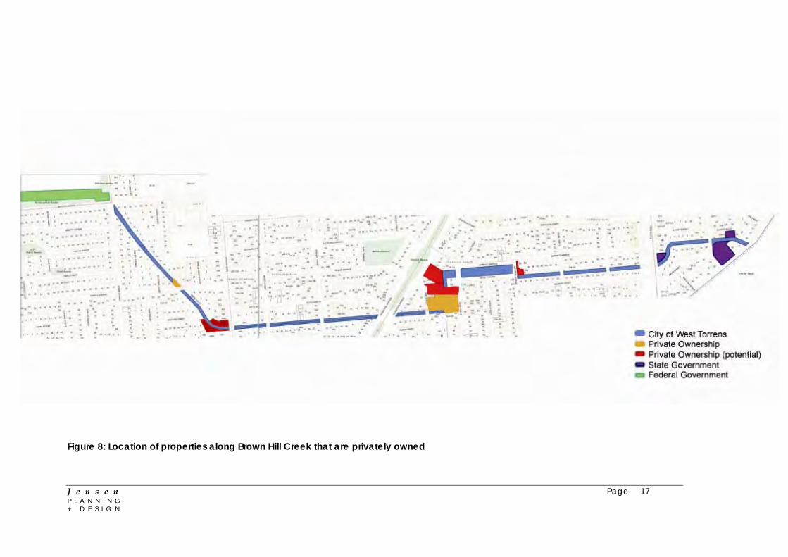
Figure 8: Location of properties along Brown Hill Creek that are privately owned
J e n s e n Page 17 P L A N N I N G + D E S I G N

6 SHARED USE PATHS, LINKAGES + ACCESS 6.1 Bicycle Lanes and Shared Paths The study area is serviced by a number of on-street bicycle lanes, as well as off road sealed pathways. Figure 10 indicates the cycling and shared use paths and sign locations within the City of West Torrens. 6.1.1 Captain McKenna Pathway
The Captain McKenna off road sealed pathway provides access between the creek (at Watson Avenue) and the Coast Park pathway. The pathway is also linked to the Reece Jennings Bikeway, which runs parallel to Tapleys Hill Road. Currently, there is no bicycle lane or pathway connection east of Watson Avenue. 6.1.2 Mike Turtur Bikeway Mike Turtur Bikeway is a shared use path and linear park, which when completed will provide a link between Glenelg and the City. The City of Marion is currently constructing a four kilometre stretch of the Mike Turtur Bikeway, between Morphett Road and South Road, incorporating public art sculptures and installations. 6.1.3 Westside Bikeway The Westside Bikeway runs between Glenelg and Mile End, utilising the area previously used for the former Holdfast Bay rail line (identified as a local heritage item in Section 4 of this report). The bikeway is a combination of shared use paths and quiet residential streets (see Figure 9). Figure 9: Westside Bikeway (Google Maps 2013)
J e n s e n Page 18 P L A N N I N G + D E S I G N

J e n s e n Page 19 P L A N N I N G + D E S I G N
6.1.4 Opportunities Whilst there are several major strategic bikeways and shared use paths surrounding the study area, there is potential to further enhance the cycle and pedestrian linkages. This will primarily be achieved by providing new linkages between these existing strategic pathways. The opportunities include:
Opportunity for the Westside Bikeway to connect to Captain McKenna Bikeway (which connects the Coast Park shared use path, which runs along the esplanade of the popular metropolitan beaches)
Potential to create an east-west link from Anzac Highway, connecting with
the Westside Bikeway. This will also provide a link between the City of Unley and the Westside Bikeway
Although outside this study area, there is potential to improve the amenity
and safety of the Captain McKenna Bikeway, particular as it runs alongside the rear fences of neighbouring properties
Potential to remove the existing fence at the beginning of the Captain
McKenna Bikeway (Watson Avenue) to encourage use of the shared path
Provision of new safe pedestrian / bicycle crossing points at main roads that enable pathways either side to be linked
Figure 11 illustrates those areas along the creekline where bike/shared path links should be created and prioritised during the design process (1 being the highest priority, 3 being the lowest priority, as determined by Jensen Planning + Design and discussed with the Steering Committee). Prioritisation of these links was based on consideration of where they may create links to existing paths and also where they could provide an important recreational function to residents within the surrounding suburbs. It should be noted that through the past development of the surrounding strategic bike pathways, valuable routes to the coast and city have been created.
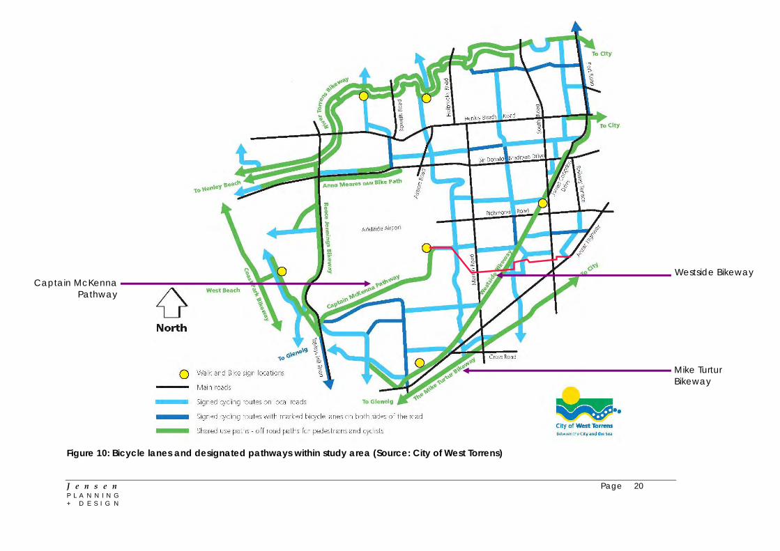
Westside Bikeway
Captain McKenna Pathway
Mike Turtur Bikeway
Figure 10: Bicycle lanes and designated pathways within study area (Source: City of West Torrens)
J e n s e n Page 20 P L A N N I N G + D E S I G N

J e n s e n Page 21 P L A N N I N G + D E S I G N
Figure 11: Improved bicycle and pedestrian path linkage priorities

6.2 Access Across the Creek 6.2.1 Pedestrian Bridges
Several pedestrian bridges provide access across Brown Hill Creek. These bridges are located at Packard Street, Gray Street, Beauchamp Street and Cross Terrace, as depicted in Figures 12-15. These access points are spatially illustrated in Figure 16. Figure 12: Packard Street Figure 13: Gray Street
J e n s e n Page 22 P L A N N I N G + D E S I G N

Figure 14: Cross Terrace Figure 15: Beauchamp Street
J e n s e n Page 23 P L A N N I N G + D E S I G N
J e n s e n Page 24 P L A N N I N G + D E S I G N
6.2.2 Road Crossings Several road crossings provide access across Brown Hill Creek. These are located at Watson Avenue, Harvey Avenue, Marion Road, Birdwood Terrace, Daly Street, South Road and Farnham Road, as depicted in Figure 16. 6.2.3 Implications for the Project There are seven road crossings and four pedestrian crossings within the study area. As a result, the study area is relatively well catered for in terms of access across the creek. It is noted that Tonkin Consulting has previously identified vehicle and pedestrian creek crossings within the study area which could be upgraded. This information is provided in their 2012 report titled ‘Airport East Shared Use Path Planning Study Report’. Existing pedestrian linkages and road crossings should be retained as part of any upgrade. These access points across the creek are important for movement and permeability of the local street network. Should it be necessary to remove an access point across the creek as part of the upgrade, the access point should be replaced. This is particularly important for those carrying services, such as sewer and water pipes (e.g. Packard Street and Beauchamp Street).

J e n s e n Page 25 P L A N N I N G + D E S I G N
Figure 16: Access across creek within study area

7 OPEN SPACE / LANDSCAPE OPPORTUNITIES 7.1 Grassmere Reserve 7.1.1 Context Grassmere Reserve is located between Cross Terrace and Garfield Avenue, Kurralta Park. The reserve is dissected by Brown Hill Creek. The reserve includes a Guides hall, playground and public seating, as well as a pedestrian footbridge across the creek, providing a linkage between Cross Terrace and Garfield Avenue (see figures 17-20). The Reserve is approximately 225 metres in length and 45 metres in width. Figure 17: Guide hall, Grassmere Reserve Figure 18: Playground, Grassmere (Google Maps 2013) Reserve (Google Maps 2013) Figure 19: Footbridge (Google Maps 2013) Figure 20: View of reserve from
Garfield Ave (Google Maps 2013)
J e n s e n Page 26 P L A N N I N G + D E S I G N

7.1.2 Opportunities Various opportunities to enhance the amenity of Grassmere Reserve and the interface with the creek environment exist. Key opportunities for improvement include the incorporation of water sensitive urban design, prevention of bank erosion, improved safety and protection / enhancement of significant trees. Further opportunities include:
Improved pedestrian access around and through the Reserve
Clearing of some small trees to allow for improved visibility to creek
Revegetation of the Reserve
Picnicking facilities
Small area of irrigated lawn in proximity to Guides Hall
Improved play facilities that promote adventure in a safe creek environment
It is noted that there may be a potential for a larger body of water for storage / amenity purposes, if required. However, it should be noted that considering the relatively small amount of open space that currently exists in the area for community use, small parks such as this should not be compromised for drainage purposes and the reserve should remain functional to a large range of users. 7.2 Watson Avenue 7.2.1 Context Watson Avenue is located at the western end of the study area, adjacent Adelaide Airport. Brown Hill Creek runs alongside Watson Avenue, forming a wide roadside reserve area (see Figures 21 and 22). The area is landscaped with trees and some low lying vegetation.
J e n s e n Page 27 P L A N N I N G + D E S I G N
Figure 21: Watson Avenue, looking east Figure 22: Watson Avenue, looking west (Google Maps 2013) (Google Maps 2013)

A bicycle path is currently provided along the creek, creating a link between the bicycle route of Galway Avenue with the Morley Street bicycle route (Tonkin Consulting 2012, p. 6). The path is part of the Bikedirect network and has been recommended to be retained, as outlined in the City of West Torrens Strategic Bicycle Plan Review (City of West Torrens 2006, p. 23). Access to the Captain McKenna Bikeway is available at the western end of Watson Avenue, which provides a link to Tapleys Hill Road. 7.2.2 Opportunities Two significant opportunities exist for the improvement of the Watson Avenue Reserve, its interface with the creek environment, and its relationship with the Captain McKenna Bikeway (Figure 23). These include:
Removal of the existing fence within the road reserve at the beginning of the bikeway, to promote use and establish inviting surroundings
Potential to enhance the amenity and safety of the Bikeway as it travels
alongside the rear fences of neighbouring properties
Potential to upgrade Watson Avenue Reserve and provide a shared use path alongside road, with sufficient width along Watson Avenue to accommodate this (as identified by Tonkin Consulting 2012, p. 7)
Figure 23: Watson Avenue opportunities (adapted from Google Maps)
Remove fencing Improve amenity
and safety of Bikeway
J e n s e n Page 28 P L A N N I N G + D E S I G N

J e n s e n Page 29 P L A N N I N G + D E S I G N
7.3 Significant Trees and Vegetation 7.3.1 Context The Development Act 1993 identifies a significant tree as:
(a) a tree declared to be a significant tree, or a tree within a stand of trees declared to be significant trees, by a Development Plan… or (b) a tree declared to be a regulated tree by the regulations, or a tree within a class of trees declared to be regulated trees by the regulations…
In total, there are twenty-one significant trees within the creek reserve or within adjacent property boundaries. Nineteen of these trees are located east of Birdwood Terrace, and ten of which are within Grassmere Reserve. The significant trees are located on the following allotments (table 1): Table 1: Significant tree locations within study area (Tonkin Consulting 2013) Street / Location Number of
Significant Trees Volume Folio
Creek reserve 2 5542 509 Gray Street 3 5975 152 Grassmere Reserve 10 5542 516 Creek reserve 1 5542 510 Creek reserve 2 2349 35 Tyson Street 1 5642 65 Tyson Street 1 5045 22 Tyson Street 1 5246 472
Although not focusing on significant trees within the study area, the ‘Ecological Risks – Stage 1’ Report prepared by Ecological Associates provides an overview of the conservation significance of the study area and identifies opportunities to improve the habitat value of Brown Hill Creek. The Report identifies trees and vegetation which are significant to the habitat of local fauna and fauna. In total, seven river red gum trees are identified as having ‘some’ or ‘moderate’ habitat value. These trees, four of which are located in Grassmere Reserve, are the only ‘significant native vegetation habitat values in the study reach’, and provide a ‘foundation on which to restore native riparian plant communities through revegetation’. 7.3.2 Implications for the Project The West Torrens (City) Development Plan states that significant trees should be preserved and tree damaging activity should not occur, unless:
(a) in the case of tree removal, where at least one of the following apply: (i) the tree is diseased and its life expectancy is short (ii) the tree represents an unacceptable risk to public or private safety (iii) the tree is within 20 metres of a residential, tourist accommodation or habitable building and is a bushfire hazard within a Bushfire Prone Area

J e n s e n Page 30 P L A N N I N G + D E S I G N
(b) the tree is shown to be causing or threatening to cause substantial damage to a substantial building or structure of value (c) all other reasonable remedial treatments and measures have been determined to be ineffective (d) it is demonstrated that all reasonable alternative development options and design solutions have been considered to prevent substantial tree-damaging activity occurring (e) in any other case, any of the following circumstances apply:
(i) the work is required for the removal of dead wood, treatment of disease, or is in the general interests of the health of the tree (ii) the work is required due to unacceptable risk to public or private safety (iii) the tree is shown to be causing or threatening to cause damage to a substantial building or structure of value (iv) the aesthetic appearance and structural integrity of the tree is maintained (v) it is demonstrated that all reasonable alternative development options and design solutions have been considered to prevent substantial tree-damaging activity occurring.
Pursuant to the Development Act 1993 section 4, tree damaging activity includes the destruction, killing or removal of a tree, severing of branches, truck or limbs, ringbarking or lopping, or any other substantial damage of a tree. Tree damaging activity involving significant trees requires development approval. Accordingly, identified significant trees and trees which provide habitat value should be preserved. If tree damaging activity is necessary for the upgrade of Brown Hill Creek, it is recommended that a full survey and assessment by a suitably qualified arborist is undertaken and development approval sought.

J e n s e n Page 31 P L A N N I N G + D E S I G N
8 CITY OF WEST TORRENS OPEN SPACE AND PUBLIC PLACE PLAN
8.1.1 Context In early 2013, Council released the City of West Torrens ‘Open Space and Public Place Plan Draft for Consultation’. One of the findings of this Plan is that, when compared with other local government areas, the City of West Torrens does not have a high provision of public open space. The aim of the Open Space and Public Place Plan is to ensure that the Council’s open space assets are utilised to their full potential. The Plan aims to deliver the following aspirations, as set out in the West Torrens Community Plan:
Enhanced natural environment Create green streetscapes and open spaces Design streetscapes to maximise opportunities for greening Incorporate native and local indigenous drought resistant plant species
into streetscapes and open spaces Develop water-smart open spaces
An attractive and functional open space network Facilitate equitable access to open spaces Develop a network of open spaces across Council, based on a balance
of environmental, social and economic factors Establish a hierarchy of maintenance for Council’s open spaces in
accordance with identified priorities
Healthy and learning communities Encourage all members of the community to pursue active and creative
lifestyles Support sporting leaders to engage with the local community and
encourage greater participation Enhance recreational facilities to provide a range of activities for all ages
and capabilities Relatively speaking, the area surrounding the section of Brown Hill Creek between Birdwood Terrace and Watson Avenue is lacking areas of open space. This is identifiable from Figure 24 below.

Figure 24: City of West Torrens Open Space (City of West Torrens 2013, p. 16)
J e n s e n Page 32 P L A N N I N G + D E S I G N

J e n s e n Page 33 P L A N N I N G + D E S I G N
The objectives, strategies and actions set out in the Plan aim to realise the Council’s Community Plan vision for open space in the West Torrens area. Many of the strategies and objectives outlined reflect the objectives of this project. The objectives of the Plan are as follows:
1. The open space we need An increased quantity, improved structure to open space and planning to
meet the future needs of the community
2. Healthy Spaces and places Open space and associated facilities which meet the access, inclusion
and health needs of the entire community and supports a healthy environment
3. Making Connections A well connected network of open space and public places which
recognise and reinforce the importance of key corridors
4. Vibrant public places Enhance quality, appeal, vibrancy and diversity of public places across
the city
5. Caring for our open space Open space that is used and valued by the community and is managed
and maintained efficiently The following strategies set out in the Plan are relevant to the project and the provision of enhanced linkages throughout the Council area, including the creek catchment:
Strategy 2.11 – Given Council’s flood risk acknowledge that open space has a role to play in stormwater management and utilise the flood prone areas as tools to negotiate open space provision outcomes with developers which address open space deficiencies Strategy 3.1 – Increase open space and public place connectability in accordance with Map 3 (refer Figure 25) through the use of bicycle lanes, appropriately located pedestrian crossings and clear directional signage, which establish walking and cycling links between existing and proposed areas of open space Strategy 3.4 – Establish stronger connections to the coast capitalising on the open space provision of Coast Park and Adelaide Shores Strategy 3.5 – Encourage the planning and development of waterways, creeks and drainage channels as green infrastructure assets that deliver recreational and environmental benefit
J e n s e n Page 34 P L A N N I N G + D E S I G N
Action 3.5.1 – Prepare concept designs for the development of linear reserves with associated environmental rehabilitation initiatives along the following waterways:
Keswick Creek Sturt Creek Brown Hill Creek Adelaide Airport ring-route
8.1.2 Implications for the Project The current lack of open space within and surrounding the study area necessitates the investigation of opportunities for this study to add to the existing quality and quantity. Within the study area, there is a potential for enhanced linkages between open space areas and the potential for the creation of linear reserves and green infrastructure. Not only can such development improve accessibility, opportunities for recreation and amenity for local residents, it can also support the enhancement of the riparian environment along Brown Hill Creek.
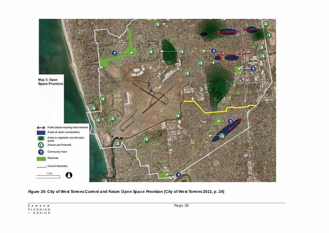
Figure 25: City of West Torrens Current and Future Open Space Provision (City of West Torrens 2013, p. 24)
J e n s e n Page 35 P L A N N I N G + D E S I G N
J e n s e n Page 36 P L A N N I N G + D E S I G N
9 REFERENCES City of West Torrens 2013, City of West Torrens Open Space and Public Place Plan, City of West Torrens, Hilton City of West Torrens, 2012, West Torrens (City) Development Plan, Consolidated 22 November 2012, City of West Torrens, Hilton City of West Torrens, 2012 (a), Housing Diversity Development Plan Amendment, City of West Torrens, Hilton City of West Torrens, 2006, City of West Torrens Strategic Bicycle Plan Review, City of West Torrens, Hilton Creer, B, 1946, ‘Historic Ashford Tree in Danger, The Mail, 23rd November. Government of South Australia, 2013, South Australian Heritage Places Database, Government of South Australia, available at planning.sa.gov.au/go/heritagesearch Tonkin Consulting, 2013, Brown Hill Keswick Creek Stormwater Project: Figures 1-9, Tonkin Consulting, Kent Town Tonkin Consulting, 2012, Airport East Shared Use Path Planning Study Report: City of West Torrens and Adelaide Airport Limited, Tonkin Consulting, Kent Town

Ref No. 2012.0679FR2D Lower Brown Hill Creek Channel Upgrade Stage 1 - Engineering Feasibility Report - Interim Report
Appendix B HEC RAS Results

0 500 1000 1500 2000 2500 3000
5
10
15
20
25
20120679 Brown Hill Plan: Plan 27 8/08/2013
Main Channel Distance (m)
Ele
vation (
m)
Legend
WS PF 1
Ground
catherine brock
Callout
Grassmere Reserve
catherine brock
Callout
South Road
catherine brock
Callout
Anzac Highway
catherine brock
Callout
Marion Road
catherine brock
Arrow
catherine brock
Textbox
To Keswick Creek
Catherine Brock
Textbox
Concrete-Lined Rectangular Channel

0 500 1000 1500 2000 2500 3000
5
10
15
20
25
20120679 LBHC Gabby Plan: Plan 12 13/08/2013
Main Channel Distance (m)
Ele
vation (
m)
Legend
WS PF 1
Ground
catherine brock
Callout
South Road
catherine brock
Callout
Anzac Highway
catherine brock
Callout
Grassmere Reserve
catherine brock
Callout
Marion Road
catherine brock
Arrow
catherine brock
Textbox
To Keswick Creek
Catherine Brock
Textbox
Gabion-Lined Open Channel

0 500 1000 1500 2000 2500 3000
5
10
15
20
25
20120679 BHC Trapz Plan: Plan 40 13/08/2013
Main Channel Distance (m)
Ele
vation (
m)
Legend
WS PF 1
Ground
catherine brock
Callout
Grassmere Reserve
catherine brock
Callout
South Road
catherine brock
Callout
Anzac Highway
catherine brock
Callout
Marion Road
catherine brock
Arrow
catherine brock
Textbox
To Keswick Creek
Catherine Brock
Textbox
Earth-Lined Trapezoidal Channel
Ref No. 2012.0679FR2D Lower Brown Hill Creek Channel Upgrade Stage 1 - Engineering Feasibility Report - Interim Report
Appendix C Constructability and Cost Estimate Report (60 m3/s Flow Rate)

BP72
Lower Brownhill Creek Flow Management
Concepts
Constructability and Cost Estimate Report

Revision Details Date Approved By
A Issued as Final for Concept Only Information 15/04/2013 Anthony Elder
©Leed Engineering Pty Limited (Leed) [2013].
Copyright in the drawings, information and data recorded in this document (the information) is the property of Leed. This document and the
information are solely for the use of the authorised recipient and this document may not be used, copied or reproduced in whole or part for any
purpose other than that for which it was supplied by Leed. Leed makes no representation, undertakes no duty and accepts no responsibility to any
third party who may use or rely upon this document or the information.

Contents
1.0 Executive Summary .................................................................................................................................. 1
2.0 Overall Project Delivery ........................................................................................................................... 2
2.1 Delivery Model ............................................................................................................................... 2
2.2 Interfaces ....................................................................................................................................... 2
2.3 Sequencing & Staging .................................................................................................................... 2
3.0 Location 1 – Downstream of South Rd .................................................................................................... 3
3.1 Site Description .............................................................................................................................. 3
3.2 Access / Egress ............................................................................................................................... 3
3.3 Enabling Works .............................................................................................................................. 3
3.4 Temporary Works .......................................................................................................................... 4
3.5 Recommended Treatment ............................................................................................................. 5
4.0 Location 2 – Downstream of Packard St .................................................................................................. 6
4.1 Site Description .............................................................................................................................. 6
4.2 Access/Egress ................................................................................................................................. 6
4.3 Enabling Works .............................................................................................................................. 6
4.4 Temporary Works .......................................................................................................................... 6
4.5 Recommended Treatment ............................................................................................................. 6
5.0 Option 1: Open Concrete Culvert............................................................................................................. 7
5.1 Overview ........................................................................................................................................ 7
5.2 Design Considerations for Construction ........................................................................................ 7
5.3 Indicative Program & Cost ............................................................................................................. 8
6.0 Option 2: Closed Concrete Culvert with Public Space ............................................................................. 9
6.1 Overview ........................................................................................................................................ 9
5.3 Design Considerations for Construction ........................................................................................ 9
5.3 Indicative Program & Cost ........................................................................................................... 10
7.0 Option 3: Gabion Wall Culvert ............................................................................................................... 11
7.1 Overview ...................................................................................................................................... 11
7.2 Design Considerations for Construction ...................................................................................... 11
7.4 Indicative Program & Cost ........................................................................................................... 12
8.0 Option 4: Open Swale ............................................................................................................................ 13
8.1 Overview ...................................................................................................................................... 13
8.2 Design Considerations for Construction ...................................................................................... 13
8.4 Indicative Program & Cost ........................................................................................................... 14
9.0 Option 5: Concealed Culvert with Low Flow Channel above ................................................................. 15
9.1 Overview ...................................................................................................................................... 15
9.2 Design Options ............................................................................................................................. 15
9.3 Indicative Program & Cost ........................................................................................................... 16
10.0 Cost Summary ........................................................................................................................................ 17
Appendix A – Concept Cost Build-up ................................................................................................................ 18
Appendix B – Cost Estimate by Section ............................................................................................................ 20

BP72 Lower Brown Hill Creek Stormwater Constructability Report 1 of 24
1.0 Executive Summary
This constructability and concept pricing report for the Lower Brown Hill Creek Stormwater Project is
intended to provide design input to the construction issues that would be likely for the various proposed
options and provide indicative comparison pricing.
The cost estimates consider supply of materials, construction, construction management and design costs
however do not consider land acquisitions which have been completed by others. The assumed conditions
of the existing creek line are derived from observations only as neither physical testing of ground
conditions nor detailed survey has been undertaken. This cost estimate is not detailed sufficiently on
actual conditions to replace a detailed cost estimate which should be done at the preliminary design phase.
Due to the difficulties in access/egress and the variability in conditions, it is recommended that
constructability input be continued through the design phase to assist with further evaluation and ensure
design can be constructed safely and within the project budget.
Options requested to be evaluated and their indicative linear meter pricing includes construction costs,
construction management, design, landscaping, design growth, contractor’s risk and client contingencies
however does not consider service relocations or pedestrian bridge crossings (which are considered in the
overall estimate):
1. Open rectangular concrete drain with shared path adjacent structure $13,445/m
2. Twin cell rectangular box culverts with shared path, lighting and landscaping $19,435/m
3. Stepped Gabion wall and reno floor drainage structure (no path) $17,855/m
4. Open swale with synthetic erosion control matting only (no path) $5,850/m
5. Option 2 complete with low flow channel and aquatic planting for treatment $21,175/m
6. Trapezoidal channel full width (no path) $12,595/m
Options 3 and 4 require significant land acquisition and this must be considered within the overall project
budget.
The overall project budget of $59.8m is suggested for the 3.68km reconstruction and upgrade of the culvert
between the Watson Ave gross pollutant traps NETLEY and First Ave FORESTVILLE. This budget is based on
Option 1 (rectangular drain with shared path) for the reserves behind properties and Option 2 (twin box
culvert) road crossings.
Figure 1: Location Plan with chainages for Lower Brown Hill Creek

BP72 Lower Brown Hill Creek Stormwater Constructability Report 2 of 24
2.0 Overall Project Delivery
2.1 Delivery Model
Due to the complex mix of design solutions to meet constructability requirements, an Early Contractor
Involvement (ECI) delivery model is recommended. Alternative methods such as Design and Construct or
Design and subsequent Construct Only construction are likely to be very difficult to sufficiently scope to
allow for competitive tendering that isn’t layered with risk/contingency funds to protect the contractor.
An ECI allows for contractor, designer and client to work collaboratively to investigate, design and deliver
the project requirements. The ECI team can interactively work through potential solutions having real
world cost input to the design solutions being offered. The project team will also provide risk models for
both client and contractor along with full open book cost estimation for the Target Outturn Cost (TOC).
Once the preliminary design and TOC are then approved, the contract can then continue as a conventional
D&C model with separation of the client from the delivery team.
2.2 Interfaces
The standard project interfaces of community, local businesses, public transport and road users are
especially prevalent on this project.
In addition there are a number of service relocations that are likely to be necessary which will require the
engagement of service authorities within the stakeholder management process.
2.3 Sequencing & Staging
Subject to final invert design for the alignment, this project is not particularly bound by sequencing or
staging. The project does lend itself to starting works from the downstream end (Watson Ave GPT) and
working progressively upstream however multiple crews could work on the full length of the creek if
necessary to meet time constraints.
Overall sequence will be driven by service relocations and road crossings to facilitate sufficient traffic
detours (so no simultaneous road closures that impact on each other). For example the Marion Rd bridge
replacement may best be done in January which typically has less traffic and long durations with no rain
and ensuring that both Watson Ave and Harvey Ave are not disturbed by other works.
An issue to overcome is the construction of the works whilst maintaining the operation of the creek for
storm flows. Bypass pipework for small base flows can be accommodated using temporary pumps and
pipework (allowed for within cost estimates) but this is not going to protect the works against rainfall
within the catchment and subsequent rework. Previous works completed in similar catchments have made
a temporary bund upstream with bypass pumping, making use of the detention volume within the creek
and discharging downstream of the works.
If budget constraints or preference is to package the works, then staging would lend itself to Marion Rd,
Daly Street and South Rd being likely stage boundaries. This is as the conditions on either side of these
sections are more typical and therefore tendering responses would be more comparable. The section
between Warwick Ave and South Rd presents the most technically challenging section assuming no land
acquisition is undertaken.
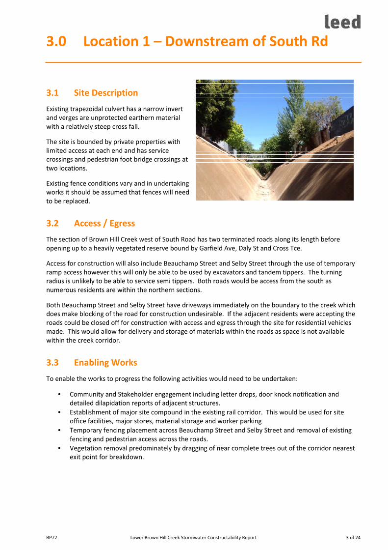
BP72 Lower Brown Hill Creek Stormwater Constructability Report 3 of 24
3.0 Location 1 – Downstream of South Rd
3.1 Site Description
Existing trapezoidal culvert has a narrow invert
and verges are unprotected earthern material
with a relatively steep cross fall.
The site is bounded by private properties with
limited access at each end and has service
crossings and pedestrian foot bridge crossings at
two locations.
Existing fence conditions vary and in undertaking
works it should be assumed that fences will need
to be replaced.
3.2 Access / Egress
The section of Brown Hill Creek west of South Road has two terminated roads along its length before
opening up to a heavily vegetated reserve bound by Garfield Ave, Daly St and Cross Tce.
Access for construction will also include Beauchamp Street and Selby Street through the use of temporary
ramp access however this will only be able to be used by excavators and tandem tippers. The turning
radius is unlikely to be able to service semi tippers. Both roads would be access from the south as
numerous residents are within the northern sections.
Both Beauchamp Street and Selby Street have driveways immediately on the boundary to the creek which
does make blocking of the road for construction undesirable. If the adjacent residents were accepting the
roads could be closed off for construction with access and egress through the site for residential vehicles
made. This would allow for delivery and storage of materials within the roads as space is not available
within the creek corridor.
3.3 Enabling Works
To enable the works to progress the following activities would need to be undertaken:
• Community and Stakeholder engagement including letter drops, door knock notification and
detailed dilapidation reports of adjacent structures.
• Establishment of major site compound in the existing rail corridor. This would be used for site
office facilities, major stores, material storage and worker parking
• Temporary fencing placement across Beauchamp Street and Selby Street and removal of existing
fencing and pedestrian access across the roads.
• Vegetation removal predominately by dragging of near complete trees out of the corridor nearest
exit point for breakdown.
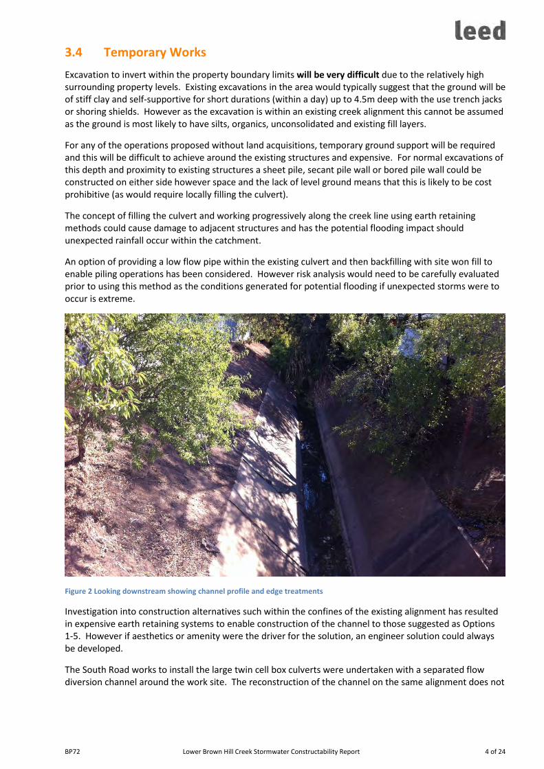
BP72 Lower Brown Hill Creek Stormwater Constructability Report 4 of 24
3.4 Temporary Works
Excavation to invert within the property boundary limits will be very difficult due to the relatively high
surrounding property levels. Existing excavations in the area would typically suggest that the ground will be
of stiff clay and self-supportive for short durations (within a day) up to 4.5m deep with the use trench jacks
or shoring shields. However as the excavation is within an existing creek alignment this cannot be assumed
as the ground is most likely to have silts, organics, unconsolidated and existing fill layers.
For any of the operations proposed without land acquisitions, temporary ground support will be required
and this will be difficult to achieve around the existing structures and expensive. For normal excavations of
this depth and proximity to existing structures a sheet pile, secant pile wall or bored pile wall could be
constructed on either side however space and the lack of level ground means that this is likely to be cost
prohibitive (as would require locally filling the culvert).
The concept of filling the culvert and working progressively along the creek line using earth retaining
methods could cause damage to adjacent structures and has the potential flooding impact should
unexpected rainfall occur within the catchment.
An option of providing a low flow pipe within the existing culvert and then backfilling with site won fill to
enable piling operations has been considered. However risk analysis would need to be carefully evaluated
prior to using this method as the conditions generated for potential flooding if unexpected storms were to
occur is extreme.
Figure 2 Looking downstream showing channel profile and edge treatments
Investigation into construction alternatives such within the confines of the existing alignment has resulted
in expensive earth retaining systems to enable construction of the channel to those suggested as Options
1-5. However if aesthetics or amenity were the driver for the solution, an engineer solution could always
be developed.
The South Road works to install the large twin cell box culverts were undertaken with a separated flow
diversion channel around the work site. The reconstruction of the channel on the same alignment does not
BP72 Lower Brown Hill Creek Stormwater Constructability Report 5 of 24
allow for this bypass and therefore design needs to be considerate of enabling flows to occur during
construction.
3.5 Recommended Treatment
Assuming that the constructed structure must confine within the existing boundaries, it is recommended
that the structure remain a trapezoidal channel through the deep sections of the creek. The excavation of
the batters would need to be undertaken progressively and shotcreted immediately following excavation to
ensure bank stability and therefore no subsidence of the adjacent ground. The batter slopes of 1H:2V
could be achieved using this method however detailed geotech investigation would be necessary to
confirm suitability.
Any existing structures along the boundary would most likely require underpinning prior to works being
undertaken.
This wider and possibly steeper structure could have a walkway/shared path constructed as an elevated
structure from one side with support outside of the high water line of the channel (subject to detailed
design).

BP72 Lower Brown Hill Creek Stormwater Constructability Report 6 of 24
4.0 Location 2 – Downstream of Packard St
4.1 Site Description
Between Marion Rd and Birdwood Tce (existing rail corridor),
the existing alignment is straight with only minor deflections
however has three distinct profiles.
From Marion Rd to just east of Wyatt Street, the trapezoidal
concrete channel has overhanging vegetation but is mostly
central within the corridor with two earthen verges.
East of Wyatt Street the channel is unlined and has numerous
edge treatments to treat erosion and act as retaining walls. The
large concrete block sections appear relatively recent
West of Birdwood Tce the profile of the channel is unprotected
earthern drainage channel.
4.2 Access/Egress
Similar to Location 1, the creek is situated between private
properties with access only at Wyatt Street and Packard Street.
Access/Egress from Birdwood Tce would require tree trimming
along Birdwood to provide sufficient sight distance requirements
for vehicles exiting.
4.3 Enabling Works
Minimal enabling works would be required however it would be
recommended that detailed dilapidation surveys were
undertaken of the adjacent retaining structures, residential
properties and buildings prior to works.
Service relocations would be required for existing services that
run across the creek alignment at Wyatt Street and Packard
Street.
4.4 Temporary Works
Temporary works would be limited to bypass pumping, temporary fencing and access ramps into and out of
the creek to facilitate construction.
4.5 Recommended Treatment
Due to the relatively shallow invert compared to surrounding area, this section could be constructed with
either open channel or dual box culvert construction and therefore constructability is not the driver for the
end solution in this area.

BP72 Lower Brown Hill Creek Stormwater Constructability Report 7 of 24
5.0 Option 1: Open Concrete Culvert
5.1 Overview
• Reinforced concrete culvert (open) with internal dimensions of 7.0m wide and 2.1m high.
• 3.0m access track immediately adjacent between property boundary and culvert.
• Safety fence between access track and culvert.
Assumptions
For the purpose of this assessment, the following assumptions have been made.
• Property boundaries have minimum 12.5m separation. This will enable the excavation to start on
the property boundary. Behind the inside of the structure, a minimum of 2.0-2.5m is necessary to
complete the excavation and the thickness of the structure. If structures are within 1.5m of the
boundary, then additional ground support or underpinning of the structure may be required (not
considered in this estimate).
5.2 Design Considerations for Construction
The culvert size is prohibitive to be supplied as precast as a single unit due to weight and confinement of
site. Alternatives are therefore constructing the concrete channel using full insitu construction, shot-crete
wall and conventional insitu slab or segmental precast with insitu stitch poured slab.
The use of precast elements will reduce the site construction program however does require additional
yard space for the storage of precast elements prior to installation. The existing rail corridor (owned by
DPTI) has sufficient space and therefore is considered an acceptable assumption.
Excavation Extent

BP72 Lower Brown Hill Creek Stormwater Constructability Report 8 of 24
The use of precast units would require
approximately 2.0-2.5m behind inside face of
the channel for the heal of the retaining wall
unit and necessary excavation benching.
Insitu concrete may require a larger working
space behind the walls to allow for formwork
shutter placement and will add to the
construction time within the water course.
The support or batter of the existing ground
will also need to be considered and therefore
may impose on the private property. The
benefit of using precast segments for the wall
is excavations are exposed for a short duration
and therefore drying out of the exposed
batters is minimal and hence excavation
collapse is less of a risk.
A clear excavation to 0.45m below invert is
also necessary to provide bedding material
and the thickness of the base slab. The use of
3%CTCR with a thin layer of paving sand as bedding is to provide a base stability and also protect the works
in case of unexpected rainfall exceeding the bypass pumping.
Positive/Negative Aspects of Cross Section for Constructability
The structural system requires retaining wall action from the heal and toe of the walls without the benefit
of top edge restraint that a box culvert provides. Unlike the culvert option, the open channel also requires
an area for the shared path which consumes land space from the drainage structure within the drainage
reserve.
Servicing an open channel is also easier compared to a culvert as it is not a confined space and can be easily
inspected. Lateral connections can also be easily connected without additional pipework or junction pits.
Under surge conditions, overflow can be seen and therefore mitigation measures can be put in place.
5.3 Indicative Program & Cost
The constructability of the open structure will depend on the final design requirements. The cost estimate
has been based on the following crew staging:
• Bypass pumping provisions
• An excavation and preparation crew
• Precast wall placement, doweled slab as a stitch pour
• Pipe connections and backfill
• Access track construction
• Fence replacement and signage.
A recommended program per construction face of 1000m should allow for 7 weeks which provides some
allowances for minor delays due to inclement weather, RDOs and public holidays.
This budget pricing has been completed without consideration to the property acquisition and property
demolition, service relocations, pedestrian bridge crossings or road crossings. The construction of precast
wall with stitch pour slab, connecting pipework, fence replacements, shared path, guard railing at road
intersections, signage and line marking, is estimated to cost in the order of $13,445/m.
Figure 3: Concept design detail for precast channel

BP72 Lower Brown Hill Creek Stormwater Constructability Report 9 of 24
6.0 Option 2: Closed Concrete Culvert with
Public Space
6.1 Overview
• Pair of conventional reinforced concrete culverts placed on grade to the existing creek invert.
• Construction of new shared path over the new works with lighting
• Landscaping to existing alignment
Assumptions
For the purpose of this assessment, the following assumptions have been made.
• The use of double culverts is acceptable rather than one structure with an internal wall.
• All existing property connections would use a collector network and then drain to the new culvert
through a grated inlet pit (GIP) or existing piped catchment connection
5.3 Design Considerations for Construction
The design solution for this option lacks the complexity of the alternatives as this design can be carried
through existing road crossings without change. The design of the amenity function is likely to have a
greater importance to the community than the drainage capability.

BP72 Lower Brown Hill Creek Stormwater Constructability Report 10 of 24
The burying of the structure assists with the technical challenges of the first option as the depth to invert is
not impacted by the placement of the path. However lateral pipework and venting of the culvert will need
to be carefully considered.
Excavation Extent
The placement of the culverts will require a minimum of 300mm on the outside of the culvert to allow for
backfill and typically bedding is sand or screenings. Unlike Option 1 – no over excavation for the heal is
required therefore overall excavation widths will cater for additional invert to natural surrounding level
without the need for additional shoring methods (excavation width within 12.5m will cater for 3 me
excavation depth).
Access / Egress
Access/egress is similar to Option 1. Crane placement of the culverts will be from on top of the culverts so
that the placement of culverts can continue following the excavation and bedding preparation. Backfilling
of the culverts progressively to provide a greater footprint could be undertaken if required to meet service
loading of the culvert.
Positive/Negative Aspects of Cross Section for Constructability
This construction has minor additional costs however the installation of the culvert at grade allows for
backfill above the culvert to match the surrounding properties (allowing for variability). This as a result
removes the need for boundary retaining walls. The alignment of the culverts within the corridor can also
be optimised to take advantage of batters and at best avoid the influence zone of adjacent structures.
5.3 Indicative Program & Cost
The constructability of the twin cell culvert will depend on the final design requirements. The cost estimate
has been based on the following crew staging:
• Bypass pumping provisions
• An excavation and preparation crew
• Precast culvert placement and backfill
• Pipe connections using collector network and GIP inlets to culvert
• Lighting and access track construction
• Fence replacement and signage.
A recommended program per construction face of 1000m should allow for 10 calendar weeks which
provides some allowances for minor delays due to inclement weather, RDOs and public holidays.
Additional time should be considered for road crossings such as Marion Rd and Anzac Hwy (6-8 weeks
each).
This budget pricing has been completed without consideration to the property acquisition and property
demolition, service relocations, pedestrian bridge crossings or road crossings. The construction of twin cell
culvert drainage structure, connecting pipework, fence replacements, shared path with lighting, signage
and line marking, is estimated to cost in the order of $19,435/m.

BP72 Lower Brown Hill Creek Stormwater Constructability Report 11 of 24
7.0 Option 3: Gabion Wall Culvert
7.1 Overview
• Battered channel with gabion basket for wall and reno mattress for floor. The gan
Assumptions
For the purpose of this assessment, the following assumptions have been made.
• Property boundaries have been acquired to make space for the new channel.
• All material is assumed to be exported off site and disposed at landfill. The disposal of concrete
and large rock structures has also been assumed to be averaged as a concrete trapezoidal channel
• The cost build-up does not consider the road crossings structures which would require separate
piling, bulkhead and bridge deck structure (or alternatively one of the previously discussed culvert
alternatives).
7.2 Design Considerations for Construction
The sketch shown indicates a batter slope of 1V:2H however during detailed design this may be able to
revise this to 1V:1H to achieve a greater channel capacity within the same excavation extent.
The invert of the channel has been assumed to have a base course of 150mm thick PM1/20. Placed over
this is a A24 bidim and a 230mm reno mattress for scour protection.

BP72 Lower Brown Hill Creek Stormwater Constructability Report 12 of 24
Figure 4 Creek line construction by Prospect Contractors
Excavation Extent
Excavation for the reno and gabion wall does not need to be overcut other than to provide sufficient
bedding material for placement. Progressive backfill behind gabions is completed during wall construction.
Positive/Negative Aspects of Cross Section for Constructability
The gabion style walls are a relatively easy to construct structure however for the gabion and reno basket
construction themselves it is recommended to have a specialist contractor. Incorrectly packed gabions and
reno do have a long term issue with rock movement within the basket which can lead to premature failure
of the structure. Shoving of the surface can also occur with incorrectly packed baskets resulting in further
disturbance to the water flow.
Gabion construction is however easily transitioned to other structures and profiles without the need for
new formwork.
7.4 Indicative Program & Cost
The constructability of the open structure with gabion edge protection is relatively quick. Once the project
has commenced, it would be anticipated that the excavation crew could continue upstream of the gabion
crew with gabions being installed at approximately 2m per day longitudinally. As the construction can be
undertaken by multiple crews the excavation and preparation will still remain as the critical path activity.
Therefore a recommended program per construction face of 1000m should allow for 5 calendar weeks
which provides some allowances for minor delays due to inclement weather, RDOs and public holidays.
Additional time should be considered for road crossings such as Marion Rd and Anzac Hwy which would
require piling and bridge structure or a culvert style construction.
Without consideration to the property acquisition and property demolition, the construction of boardwalks
or path, bridge crossings and road crossings, the gabion style replacement is estimated to cost in the order
of $17,855/m.

BP72 Lower Brown Hill Creek Stormwater Constructability Report 13 of 24
8.0 Option 4: Open Swale
8.1 Overview
• Open swale with 1V:4H batters.
Assumptions
For the purpose of this assessment, the following assumptions have been made.
• Property acquisition and demolition costs are captured by others
• Costing assume 10% of excess spoil is Low Level Waste and remainder is clean waste fill.
8.2 Design Considerations for Construction
The open swale design is suitable for straight lengths or gently curved however scour protection would be
required for changes in direction, tapers and for lateral connections (as cannot assume drain has flow when
lateral flows enter). As a result it is recommended that an alternate option is selected for changes in
direction.
Where the creek alignment does taper to suit alternate structures, the use of the gabion style construction
is recommended for long term scour and embankment stability.
The specification of a synthetic jute is recommended for all exposed natural material to prevent long term
scour. The use of GrassRoots is an example that would allow for grass and other vegetation to grow
through the jute however being synthetic would provide long term scour protection.

BP72 Lower Brown Hill Creek Stormwater Constructability Report 14 of 24
Possible Construction Sequence
The construction of this option would be dependent on other structures being completed prior to swale
works. For example upgrades to Watson Ave, Harvey Ave, Marion Rd, existing rail corridor, Daly St would
be required to then be able to complete the swale transitions to the finished structure. Once these
structures are near completed, multiple excavation fronts could occur simultaneously to then complete the
work.
Due to the need to provide scour protection to the surface, the excavation and final treatment work would
best be undertaken during the September to November and January to April months.
Positive/Negative Aspects of Cross Section for Constructability
Additional excavation would be required over depth due to natural ground profiles typically being deeper
than the required 2.1m as shown. This would therefore limit the opportunity for this profile to be used
other than downstream of Warwick Ave even with considering property acquisition.
The width of the construction is very sensitive to the depth of the channel given the batter slopes
requirements. Therefore the risk of excavation volumes assumed for this costing being in error is high. For
example this estimate assumes that the channel profile is 1.8m water depth + 0.3m freeboard which is
2.1m and represents an average spoil volume of 16m3. However typical invert to surrounding areas is on
average 2.7m which therefore changes the width and the volumes of export to approximately 30m3. For
the estimate provided, it has been assumed that 30m3 will be exported off site.
Transitions to road crossings would require long taper lengths that may prove alternative treatments are
preferred.
Temporary Works for Rain Interruptions
The swale would be treated with scour protection progressively with excavation and therefore temporary
works would be minimal and limited to conventional soil erosion and drainage management plan (SEDMP)
measures.
8.4 Indicative Program & Cost
The constructability of the open channel is relatively quick with excavation and scour treatment being
undertaken at an average of 6m production per day but could be as high as 9.5m per day in the lower areas
west of Marion Rd. This is however after the construction of other crossing points has been undertaken.
A recommended program per construction face of 1000m should allow for 4 weeks which provides some
allowances for minor delays due to inclement weather, RDOs and public holidays.
Without consideration to the property acquisition and property demolition, the construction of boardwalks
or path, bridge crossings and road crossings, the open swale replacement is estimated to cost in the order
of $5,850/m.

BP72 Lower Brown Hill Creek Stormwater Constructability Report 15 of 24
9.0 Option 5: Concealed Culvert with Low
Flow Channel above
9.1 Overview
• Twin cell culvert with low flow channel above culvert. Access track provided and a combination of
aquatic and terrestrial plantings to provide water treatment and amenity planting.
All constructability, sequencing and design requirements would be as per Option 2.
9.2 Design Options
The low flow channel would most likely be the result of overland flow catchments, including roof runoff
from adjacent properties. The channel would have field gully pits that would then feed the culverts
underneath.
The field gully pits would act to provide inflow for level control on the swale, access to the culverts for
inspection and “breathers” for the culvert.
If the wetlands are to retain a low level of water to maintain water to aquatic plants, then the use of clay
liner or geosyntetic liner will be required.

BP72 Lower Brown Hill Creek Stormwater Constructability Report 16 of 24
9.3 Indicative Program & Cost
The construction sequence is as per Option 2 however once the box culvert is completed, another
earthworks phase would be undertaken to construct the linear wetland and installation of field gully pits to
the culvert.
It would be anticipated that a further 6 weeks per 1000m (total 21 weeks) would be required for the
wetland aspect including lining, topsoil and plantings.
This budget pricing has been completed without consideration to the property acquisition and property
demolition, service relocations, pedestrian bridge crossings or road crossings. The construction of twin cell
culvert drainage structure, connecting pipework, fence replacements, low flow wetlands, shared path,
signage and line marking, is estimated to cost in the order of $21,175/m.

BP72 Lower Brown Hill Creek Stormwater Constructability Report 17 of 24
10.0 Cost Summary
It is recommended that due to the concept level analysis of option placement to physical space and
requirements, it is recommended that the following factors be applied.
• Contractors risk/contingencies 10%
• Contractors Profit & Overheads 6%+6%
• Design scope growth 5%
• Project (Client) risk/contingencies 10%
The cost per section have been built using first principles cost estimation and using 100m sections.
Therefore efficiencies for longer lengths will result in cost savings however this is likely to be offset by
transitions and rework due to rainfall events. Lost time due to rain has been considered and included,
however it is likely that the project would ideally be delivered over successive summers with a
demobilisation at the start of winter and a remobilisation at the start of spring.
Construction costs provided include construction Management and Supervision, site office premises and
facilities, attendant plant and all costs associated with the construction. Construction costs include disposal
fees for concrete and demolition waste, clean waste fill and a provision for contaminated material, supply
and placement of new structures and connection of existing drainage structures to the new structure.
A breakdown of recommended construction methods by each section and the likely costs are provided in
Appendix A.
The overall construction project budget of $59.8m is recommended for the 3.68km reconstruction and
upgrade of the culvert between the Watson Ave gross pollutant traps NETLEY and First Ave FORESTVILLE.
This budget is based on the conservative upgrade with a twin box culvert with shared path and high degree
of landscaping along the corridor.

BP72 Lower Brown Hill Creek Stormwater Constructability Report 18 of 24
Appendix A – Concept Cost Build-up

BP72 Lower Brown Hill Creek Stormwater Constructability Report 19 of 24
BP
72
- B
row
n H
ill
Ke
swic
k C
ree
k S
torm
wa
ter
Pro
ject
- L
ow
er
Bro
wn
Hil
l C
ree
k C
on
cep
t
Pro
ject
Bu
ild
up
CH
Sta
rtC
H F
inis
hO
pti
on
De
scri
pti
on
Pe
de
stri
an
Bri
dg
es
PC
Su
ms
Se
rvic
e
PC
Su
ms
Ra
w B
uil
d
Ra
te
Du
rati
on
Co
ntr
act
ors
Ris
k
Co
ntr
act
or
P&
O
Co
nst
ruct
ion
Co
nct
ract
Va
lue
De
sig
n S
cop
e
Ch
an
ge
Co
nti
ng
en
cie
s
De
sig
n F
ee
s
Cli
en
t
Ris
k /
Co
nti
ng
en
cie
s
Su
bto
tal
04
00
1W
ats
on
Av
e R
ese
rve
4,0
00
8,5
00
12
4 d
ay
s3
40
,40
0
4
87
,26
0
4,5
47
,76
0
22
7,3
88
90
,95
5
4
86
,61
0
5
,35
2,8
00
40
04
25
2R
CW
ats
on
Av
e R
oa
d C
ross
ing
4,0
00
21
,70
0
2
2 d
ay
s5
4,6
50
7
8,2
34
7
30
,18
4
3
6,5
09
4
3,8
11
81
,05
0
89
1,6
00
42
58
10
1-
8
,50
0
1
20
da
ys
32
7,2
50
46
8,4
38
4
,37
2,0
88
2
18
,60
4
8
7,4
42
46
7,8
13
5,1
46
,00
0
81
08
35
2R
CH
arv
ey
Av
e R
oa
d C
ross
ing
7,5
00
21
,70
0
2
2 d
ay
s5
5,0
00
7
8,7
32
7
34
,83
2
3
6,7
42
4
4,0
90
81
,56
6
89
7,3
00
83
51
08
01
Fle
tch
er
Str
ee
t R
ese
rve
-
8,5
00
76
da
ys
20
8,2
50
29
8,0
98
2
,78
2,2
48
1
39
,11
2
5
5,6
45
29
7,7
01
3,2
74
,80
0
10
80
11
20
2R
CM
ari
on
Rd
Cro
ssin
g9
0,0
00
2
1,7
00
36
da
ys
95
,80
0
13
7,1
36
1
,27
9,9
36
6
3,9
97
7
6,7
96
14
2,0
73
1,5
62
,90
0
11
20
16
00
12
0,0
00
14
,60
0
8,5
00
14
9 d
ay
s4
11
,46
0
5
88
,97
9
5,4
97
,13
9
27
4,8
57
10
9,9
43
5
88
,19
4
6
,47
0,2
00
16
00
17
50
2R
CE
xis
tin
g R
ail
Re
serv
e-
60
,00
0
21
,70
0
1
32
da
ys
33
1,5
00
47
4,5
28
4
,42
8,9
28
2
21
,44
6
2
65
,73
6
49
1,6
11
5,4
07
,80
0
17
50
21
00
12
0,0
00
8,5
00
10
9 d
ay
s2
99
,50
0
4
28
,71
2
4,0
01
,31
2
20
0,0
66
80
,02
6
4
28
,14
0
4
,70
9,6
00
21
00
21
25
2R
CD
aly
St
-
1
2,0
00
2
1,7
00
22
da
ys
55
,45
0
79
,37
4
74
0,8
24
37
,04
1
44
,44
9
8
2,2
31
9
04
,60
0
21
25
23
50
32
0,0
00
8,7
00
11
,30
0
5
0 d
ay
s2
57
,12
0
3
68
,05
4
3,4
35
,17
4
17
1,7
59
68
,70
3
3
67
,56
4
4
,04
3,3
00
23
50
28
70
65
0,0
00
6,2
00
7,9
00
12
0 d
ay
s4
16
,42
0
5
96
,07
8
5,5
63
,39
8
27
8,1
70
11
1,2
68
5
95
,28
4
6
,54
8,2
00
28
70
29
15
Ex
isti
ng
So
uth
Rd
Ex
isti
ng
Cu
lve
rts
-
-
-
-
-
-
-
29
15
31
35
14
0,0
00
6,2
00
8,5
00
69
da
ys
19
1,6
20
27
4,2
98
2
,56
0,1
18
1
28
,00
6
5
1,2
02
27
3,9
33
3,0
13
,30
0
31
35
31
60
2R
CF
arn
ha
m R
d1
6,0
00
2
1,7
00
22
da
ys
55
,85
0
79
,95
0
74
6,2
00
37
,31
0
44
,77
2
8
2,8
28
9
11
,20
0
31
60
32
90
1-
8
,50
0
4
1 d
ay
s1
10
,50
0
1
58
,18
4
1,4
76
,38
4
73
,81
9
29
,52
8
1
57
,97
3
1
,73
7,8
00
32
90
33
60
2R
CA
NZ
AC
Hw
y1
45
,00
0
2
1,7
00
62
da
ys
16
6,4
00
23
8,2
00
2
,22
3,2
00
1
11
,16
0
1
33
,39
2
24
6,7
75
2,7
14
,60
0
33
60
36
80
21
6,0
00
1
2,3
00
12
8 d
ay
s3
95
,20
0
5
65
,70
4
5,2
79
,90
4
26
3,9
95
10
5,5
98
5
64
,95
0
6
,21
4,5
00
Su
bto
tals
39
0,2
00
49
da
ys
3,7
72
,37
0
5,3
99
,96
0
50
,39
9,6
30
2,5
19
,98
2
1,4
43
,35
7
5
,43
6,2
97
5
9,8
00
,50
0
5.0
%3
.8%
10
.0%
Pri
cin
g L
oo
ku
p%
of
Co
nst
rct'
Va
lue
% o
f D
ire
ct C
ost
s
% o
f C
on
stru
ct +
Sco
pe
Ris
k +
De
sig
n
Fe
es
Co
de
De
scri
pti
on
Ra
te
$/m
Du
rati
on
Da
ys/
m
1O
pti
on
1 -
Op
en
Ch
an
ne
l8
,50
0
0.3
11
3,4
30
2O
pti
on
2 -
Bo
x C
ulv
ert
12
,30
0
0
.41
9,4
34
2R
CO
pti
on
2 R
C -
Bo
x C
ulv
ert
21
,70
0
0
.88
34
,28
6
3O
pti
on
3 -
Ga
bio
n C
ha
nn
el
11
,30
0
0
.22
17
,85
4
4O
pti
on
4 -
Op
en
Sw
ale
3,7
00
0
.15
5,8
46
5O
pti
on
5 -
Lo
w f
low
we
tla
nd
ov
er
bo
x c
ulv
ert
13
,40
0
0
.42
1,1
72
6O
pti
on
6 -
De
ep
Tra
pa
zoid
al
Ch
an
ne
l (N
o P
ath
)7
,90
0
0.2
31
2,4
82
Fa
cto
rs1
0%
Co
ntr
act
or
Ris
k/C
on
tin
ge
nci
es
12
%C
on
tra
cto
r P
rofi
t &
Ov
erh
ea
ds
5%
De
sig
n s
cop
e c
ha
ng
e C
on
tin
ge
nci
es
(co
nst
ruct
va
lue
)
10
%P
roje
ct (
Cli
en
t) R
isk
/Co
nti
ng
en
cie
s

BP72 Lower Brown Hill Creek Stormwater Constructability Report 20 of 24
Appendix B – Cost Estimate by Section

BP72 Lower Brown Hill Creek Stormwater Constructability Report 21 of 24
BP72 - Lower Brown Hill Creek Stormwater Project - Element Summary
Indirects Activity Budget
BP7201 Recurring Overheads 2,711,904.77
BP7201 WC01 Management and Supervision 1,604,392.00
BP7201 WC02 Site Facilities, Ablutions and Stores 115,654.58
BP7201 WC03 Freight/Deliveries (after mobilisation) 115,654.58
BP7201 WC04 Attendant Plant 845,250.00
BP7201 WC10 Survey 21,233.60
BP7201 WC16 Team Management 9,720.00
BP7202 Non Recurring Overheads 790,870.00
BP7202 WC01 Mobilisation 31,375
BP7202 WC02 Site Set-up 29,050
BP7202 WC03 Site Compound & Laydown Areas 57,485
BP7202 WC04 Guarantees / Security 58,500
BP7202 WC05 CITB Levy 178,750
BP7202 WC06 Insurances 38,000
BP7202 WC08 Demobilisation 6,390
BP7202 WC09 Clear Site & Make Good Compound - Pipeline 20,570
BP7202 WC10 As Constructed Drawings 18,750
BP7202 WC13 Wet Weather / Lost Time Labour 352,000
Directs Activity Rate $/m
BP7203 Option 1 - Open rectangular concrete channel 8,499.54
BP7203 WC01 Temporary Works including bypass 166.00
BP7203 WC02 Demolish existing and disposal 377.00
BP7203 WC03 Cut to Spoil 2,744.76
BP7203 WC04 Base Preparation and Placement of Precast Wall 2,505.82
BP7203 WC05 Stitch Pour Slab 1,760.95
BP7203 WC06 Backfill and connections 497.34
BP7203 WC07 Path Construction 124.27
BP7203 WC08 Fencing and Guardrails 274.90
BP7203 WC09 Site Clean Up 48.50
BP7204 Option 2 - Twin cell rectangular box culvert 12,249.12
BP7204 WC01 Temporary Works including bypass 184.50
BP7204 WC02 Demolish existing and disposal 377.00
BP7204 WC03 Cut to Stockpile & Spoil 2,306.40
BP7204 WC04 Base Preparation 562.65
BP7204 WC05 Placement of Precast 7,251.00
BP7204 WC06 Backfill and connections 813.59
BP7204 WC07 Path Construction 193.97
BP7204 WC08 Fencing, Lighting and landscaping 511.50
BP7204 WC09 Site Clean Up 48.50
BP7205 Option 2 RC - Twin cell rectangular box culvert (Road Crossing) 21,660.78
BP7205 WC01 Temporary Works including bypass 4,336.00
BP7205 WC02 Demolish existing and disposal 1,903.24
BP7205 WC03 Cut to Stockpile & Spoil 2,441.50
BP7205 WC04 Base Preparation 577.35
BP7205 WC05 Placement of Precast 7,256.80
BP7205 WC06 Backfill and connections 879.32
BP7205 WC07 Road Reconstruction 3,259.07
BP7205 WC08 Fencing, Lighting and landscaping 833.50
BP7205 WC09 Site Clean Up 174.00
BP7206 Option 3 - Stepped gabion and reno channel 11,215.04
BP7206 WC01 Temporary Works including bypass 160.00
BP7206 WC02 Demolish existing and disposal 377.00
BP7206 WC03 Cut to Spoil 3,383.70
BP7206 WC04 Base Preparation (parrallel to cut to spoil) 183.00
BP7206 WC05 Gabion Wall & Reno Mattress Construction 6,204.75
BP7206 WC06 Backfill and connections 282.12
BP7206 WC07 Path Construction 193.97
BP7206 WC08 Fencing and Guardrails 382.00
BP7206 WC09 Site Clean Up 48.50
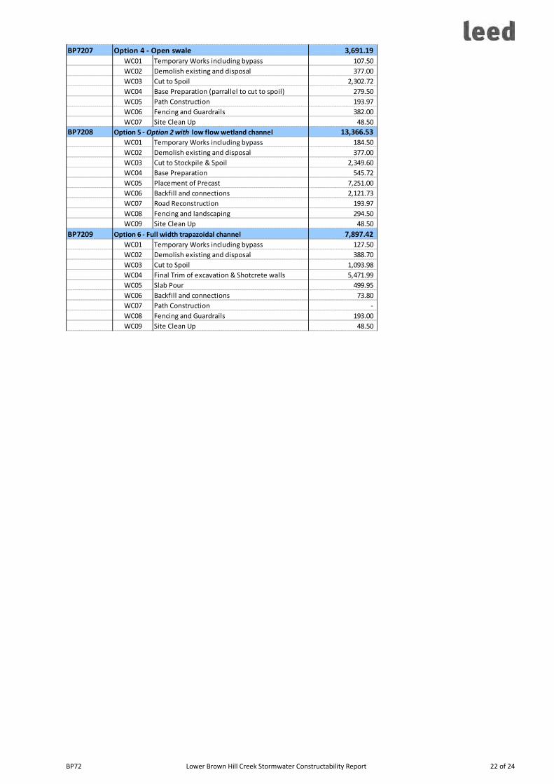
BP72 Lower Brown Hill Creek Stormwater Constructability Report 22 of 24
BP7207 Option 4 - Open swale 3,691.19
BP7207 WC01 Temporary Works including bypass 107.50
BP7207 WC02 Demolish existing and disposal 377.00
BP7207 WC03 Cut to Spoil 2,302.72
BP7207 WC04 Base Preparation (parrallel to cut to spoil) 279.50
BP7207 WC05 Path Construction 193.97
BP7207 WC06 Fencing and Guardrails 382.00
BP7207 WC07 Site Clean Up 48.50
BP7208 Option 5 - Option 2 with low flow wetland channel 13,366.53
BP7208 WC01 Temporary Works including bypass 184.50
BP7208 WC02 Demolish existing and disposal 377.00
BP7208 WC03 Cut to Stockpile & Spoil 2,349.60
BP7208 WC04 Base Preparation 545.72
BP7208 WC05 Placement of Precast 7,251.00
BP7208 WC06 Backfill and connections 2,121.73
BP7208 WC07 Road Reconstruction 193.97
BP7208 WC08 Fencing and landscaping 294.50
BP7208 WC09 Site Clean Up 48.50
BP7209 Option 6 - Full width trapazoidal channel 7,897.42
BP7209 WC01 Temporary Works including bypass 127.50
BP7209 WC02 Demolish existing and disposal 388.70
BP7209 WC03 Cut to Spoil 1,093.98
BP7209 WC04 Final Trim of excavation & Shotcrete walls 5,471.99
BP7209 WC05 Slab Pour 499.95
BP7209 WC06 Backfill and connections 73.80
BP7209 WC07 Path Construction -
BP7209 WC08 Fencing and Guardrails 193.00
BP7209 WC09 Site Clean Up 48.50

Ref No. 2012.0679FR2D Lower Brown Hill Creek Channel Upgrade Stage 1 - Engineering Feasibility Report - Interim Report
Appendix D MCA Analysis spreadsheet

Ref No. 2012.0679FR2D Lower Brown Hill Creek Channel Upgrade Stage 1 - Engineering Feasibility Report - Interim Report