Longitude and photography: picturing the invisible · invisible line is hard to underestimate as it...
18
Longitude and photography: picturing the invisible “Even to point is always to point…somewhere; and this is not only marks a place but makes it the subject of the particular attention” (Wood, 1992, p.24) I am standing on the edge of a field, my boots sinking deep into the mud. There are bare fields to the left and to the right stretching as far as the horizon. There is very little to hold on to in this minimalistic Fenland landscape. Far away, some trees punctuate the horizon and my eyes grasp at them as if they will save me from the emptiness. There is nothing in the trees or in the field to mark the line of the Prime Meridian that, according to my GPS 1 recorder, passes straight under my feet. Yet, the significance of this invisible line is hard to underestimate as it divides the East from the West 2 , cutting purposefully through the landscape. As I am pondering over its contradictory meanings, I recall the past and contemporary explorations encompassing meridians. Cartography and mapping have long been popular artistic means of engaging with landscape. 3 Whilst certain cartographic practices translate explicitly into the land, more abstract concepts such as meridian lines have rather ambiguous links. My photographic journey along the Prime Meridian 4 commences with revisiting some historic and contemporary projects that followed longitude or latitude. Drawing on diverse authors, including O’Sullivan, Gohlke, Crane and Moore 5 I am keen to explore common ground. What did cartographic lines compel them to do and believe? Why did they choose to follow the invisible and how does it connect to real? *** Over the centuries humankind has expended “the untold thousands of hours of thought and labour…to tell…exactly where we are” (Andrewes, 1996, p.1). This fight for determining one’s position has amassed numerous tools. In cartography, longitudes provide coordinates 6 whilst location-tracking devices pinpoint our exact position at any time. On maps, the meridians hold power dissecting the countries, “indifferent both to topography and state boundaries.” 7 Despite their scientific usefulness, their link with the real landscape seems obscure. One-hundredth meridian is an exception. As Jurovics (2015, p.114) put it, “no other longitude in the United States carries the authority of the 100 th meridian.” 8 Timothy O’Sullivan took part in two government-sponsored surveys along the 40 th parallel and 100 th meridian. 9 Some 130 years later Andrew Moore spent a decade photographing the prairies west of 100 th meridian.
Transcript of Longitude and photography: picturing the invisible · invisible line is hard to underestimate as it...

Longitude and photography: picturing the invisible
“Even to point is always to point…somewhere; and this is not only marks a place but makes it the subject of the particular attention”
(Wood, 1992, p.24)
I am standing on the edge of a field, my boots sinking deep into the mud. There are bare fields to the left and to the right stretching as far as the horizon. There is very little to hold on to in this minimalistic Fenland landscape. Far away, some trees punctuate the horizon and my eyes grasp at them as if they will save me from the emptiness. There is nothing in the trees or in the field to mark the line of the Prime Meridian that, according to my GPS1 recorder, passes straight under my feet. Yet, the significance of this invisible line is hard to underestimate as it divides the East from the West2, cutting purposefully through the landscape. As I am pondering over its contradictory meanings, I recall the past and contemporary explorations encompassing meridians. Cartography and mapping have long been popular artistic means of engaging with landscape.3 Whilst certain cartographic practices translate explicitly into the land, more abstract concepts such as meridian lines have rather ambiguous links. My photographic journey along the Prime Meridian4 commences with revisiting some historic and contemporary projects that followed longitude or latitude. Drawing on diverse authors, including O’Sullivan, Gohlke, Crane and Moore5 I am keen to explore common ground. What did cartographic lines compel them to do and believe? Why did they choose to follow the invisible and how does it connect to real? *** Over the centuries humankind has expended “the untold thousands of hours of thought and labour…to tell…exactly where we are” (Andrewes, 1996, p.1). This fight for determining one’s position has amassed numerous tools. In cartography, longitudes provide coordinates6 whilst location-tracking devices pinpoint our exact position at any time. On maps, the meridians hold power dissecting the countries, “indifferent both to topography and state boundaries.”7 Despite their scientific usefulness, their link with the real landscape seems obscure. One-hundredth meridian is an exception. As Jurovics (2015, p.114) put it, “no other longitude in the United States carries the authority of the 100th meridian.”8 Timothy O’Sullivan took part in two government-sponsored surveys along the 40th parallel and 100th meridian.9 Some 130 years later Andrew Moore spent a decade photographing the prairies west of 100th meridian.

O’Sullivan pictured the barren mountains and canons of Colorado and Utah and not Nebraska’s plains, but was it his choice?10 Unlike Moore, he did not choose the meridian11 though evidently he enjoyed independence at work.12 Yet, the tension between his internal choices and the external demands manifested in his images adding to their complexity. Surpassing the expeditions’ requirements,13 they revealed his unique experimental vision. In Black Canyon (1875) and Steamboat Spring (1868), O’Sullivan’s way of representing the uncharted “landscape in turmoil” (Jurovics, 2010, p.19) “as objectively and factually as possible,” (Weston, 1975, p.124) without idealizing or relying on traditional pictorial rhetoric seems akin to the surveyors’ efforts.14
1. O'Sullivan (1875) Black Canyon
2. O'Sullivan (1867) Steamboat Springs His Shoshone Falls (1868; 1874)15 images show his growing intimacy with the landscape: starting at a distance, he moves closer until his frame is filled with mist, conveying his physical and emotional experience.

3. O'Sullivan (1868) Shoshone Falls, Idaho, Plate 134
4. O'Sullivan (1868) Shoshone Falls, Idaho, Plate 137
5. O'Sullivan (1868) Shoshone Falls, Idaho, Plate 138
6. O'Sullivan (1874) Shoshone Falls, Idaho

Like O’Sullivan, Moore answered the “spiritual call of empty space” where “there is very little to see.” The theme of unseen is central to Dirt Meridian (Moore, 2015). Approaching Dust Storm and Schoolhouse (2013) capture what is visible to the eye but a closer look reveals the land’s hidden history and narrative, “the things that are unseen but very much present in that landscape“ (Kubicek, 2015).
7. Moore (2013) Approaching Dust Storm, Floyd Country, Texas
8. Moore (2013) Schoolhouse on the China Pasture, Cherry County, Texas Whilst O’Sullivan captured the wilderness before the human expansion, Moore’s landscape is intrinsically linked with people. Even the images devoid of people, as those shown above, connect to the land’s occupants.

In Routing the Pipeline (2014) we see pipelines slicing the landscape, as uncompromising as the meridian.
9. Moore (2014) Routing the Pipeline, McKenzie County, North Dakota
10. Moore (2014) Broken Pivot, Sheridan County, Nebraska Moore’s aerial and traditional views are woven into the Flyover country’s16 narrative. Resembling a close up of Emmet Gowin’s17 aerial views, Broken Pivot (2014) shows how the man reshapes his environment.18 Moore’s framing of our relationship with land is reminiscent of Joe Deal’s Fault Zone and West and West (Deal, 2009). In Fault Zone, Deal follows an invisible fault line in Southern California highlighting the complexity and brittleness of the man-made world built in the unstable ecosystem. In West and West (2009), Deal’s choice of square format and traditional surveyor’s view distilled Missouri Plateau (2005) into its classical elements, sky and land. Resonating strongly with O’Sullivan’s and the 19th century survey photography along the 6th Meridian,19 Deal (2009) compares photographers to surveyors as both “impose a frame around something that has no clear boundaries of its own.”

11. Deal (2005) Missouri Plateau Setting a boundary to boundless space is a concern I share with these photographers. This was a theme I explored in my Below the Sea project that featured Fenland. The use of long-term exposure in the images below manifested in the layers of individual moments and memories captured in each frame. I tried to convey my sense of the landscape as fluid and moving, and the connections between its elements.
12. Sellen (2015) Bedford Level South
13. Sellen (2015) Rapeseed at Burnt Fen This theme links strongly with my new project so I turn to Frank Gohlke to find out more. Like Deal, Gohlke belongs to the New Topographic movement of
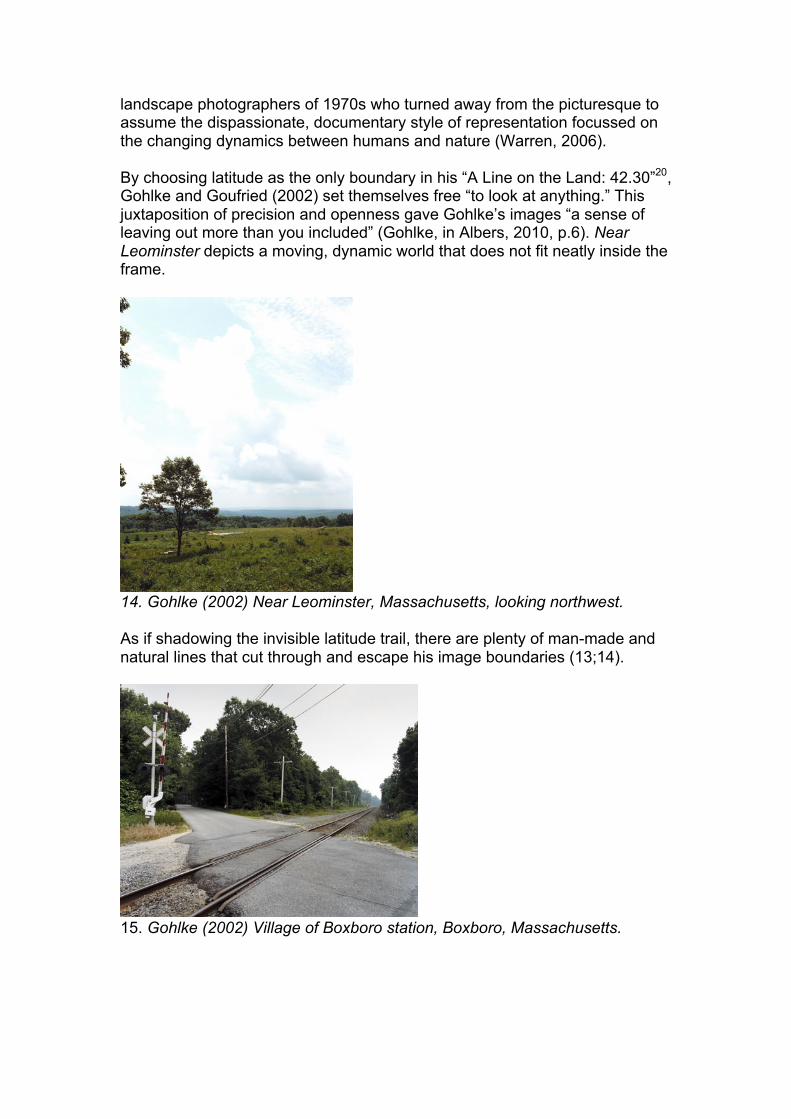
landscape photographers of 1970s who turned away from the picturesque to assume the dispassionate, documentary style of representation focussed on the changing dynamics between humans and nature (Warren, 2006). By choosing latitude as the only boundary in his “A Line on the Land: 42.30”20, Gohlke and Goufried (2002) set themselves free “to look at anything.” This juxtaposition of precision and openness gave Gohlke’s images “a sense of leaving out more than you included” (Gohlke, in Albers, 2010, p.6). Near Leominster depicts a moving, dynamic world that does not fit neatly inside the frame.
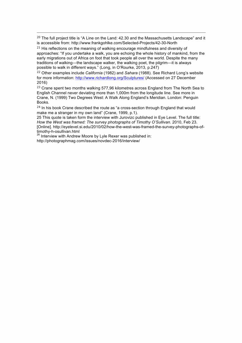
14. Gohlke (2002) Near Leominster, Massachusetts, looking northwest. As if shadowing the invisible latitude trail, there are plenty of man-made and natural lines that cut through and escape his image boundaries (13;14).
15. Gohlke (2002) Village of Boxboro station, Boxboro, Massachusetts.

16. Gohlke (2002) Connecticut River near Hubbardston, Massachusetts, looking north. For his project Gohlke mostly travelled by car. My next project will be completed by foot so what can I learn from works made by walking? I am turning to Richard Long, Mark Power and Nicholas Crane to find out about their relationship with lines and the unseen. Richard Long, who used landscape vistas as his artistic canvas, referred to walking “as a means to explore relationships between time, distance, geography and measurement” (O’Rourke, 2013).21 His A Line Made By Walking (1968) captured the invisible: it speaks about permanence and the brevity of our experience. Bolivia (1981)22 depicts a line, similar to longitude. Its semi-permanent nature invites to reflect on the ways we intervene in and engage with a landscape.
17. Long (1968) A Line Made By Walking 18. Long (1981) Bolivia If Richard Long shows natural vistas, Mark Power in his “26 Different Endings” (2007) offers a different kind of emptiness.

Following the arbitrary boundary of the A to Z London, he visits indistinguishable urban suburbs strangely devoid of life, their absence of names in the tittles, such as A148 South above, hints to their inaudible identities.
19. Power (2007) A 148 South His square format and dispassionate way of framing in K 13 North resembles the ‘surveyor’s view’ adopted by Deal. Like Gohlke and Deal, Power’s emotional and physical experiences translate powerfully into his images.
20. Power (2007) K 13 North What Power conveys visually, Crane expresses with words: “we have traded local interest for global unfamiliarity” (Crane, 1999, p.352). This poignant observation made at the end of his “England’s Meridian” walk frames his findings quite fittingly. Crane’s “Two Degrees West” walk along a meridian23 bears close resemblance to my next project idea. He describes his route as “counter-intuitive” and the places he visited as “randomly selected” by the arbitrary longitude line.24 This ingenious setup, in my view, invites approaching places indiscriminately, with an open mind, mirroring the route

that “neither followed the flow of the land nor the currents of culture and history that habitually steer the writer and traveller” (Crane, 1999, p.12). *** In summary, photographers, who have been considered in this essay, have used lines as a way of engaging with landscape. There are natural visible lines such as rivers and valleys that “provide geological, geographical and political ways of dividing space”. There are also railway tracks, roads and other man-made visible lines that are present in the landscape. Then there are the invisible lines that in the hands of the artists become “a tool for understanding…the way of entering the landscape” (Gohlke, 2009, p. 176). Layer by layer, as we deconstruct the landscape it reveals its complex, hidden meanings. Cartographic lines take a powerful place in the setup of these projects serving as “walking protocols” (O’Rourke, 2013, p. 49) and guiding our engagement with the landscape. They are a thread that holds the narrative together, a boundary containing the boundless; they are the reminder of the constructed nature of landscape. As Tim Ingold (2015) observed, “in the life of lines, parts are not components; they are movements.” In individual images, the visible lines such as roads create “visual conversation between the sky and the land” (Gohlke, 2009, p.254). Making the lines our principle of engagement incites us to consider landscape as a constantly changing, “dynamic set of relationships.” This requires listening to a space and entering a dialogue. As Gohlke (2009, p.189) pointed out, “as a photographer…I am not only simply the interrogator of a passive subject, I, too, am being questioned.” The common ground in all these projects is their attention to negative, empty space. Capturing emptiness requires certain choices. O’Sullivan’s had to “figure out how to put that [landscape] into an 10 x 12 inch sheet of glass.”25 In Dirt Meridian, Moore worked from the edges to bring “that vastness inside.”26 Gohlke experimented with the infinite choices in “42.30” and Deal surveyed the passing time in “West and West.” The lesson they convey is to be open, to listen and to keep asking questions such as ‘What is this landscape trying to tell me?’ or ‘What is the question here?’ The juxtaposition between the unlimited and precise elements (e.g. location coordinates) is another commonality that raises important questions. The image titles guide our engagement with the landscape even when they don’t give away specific coordinates. So, does it matter if we know precisely where we are and if so, why? What does a specific location mean? My own conclusion is that a precise location could be a powerful statement acting as a proof of existence, a reality check that is hard to dismiss. The coordinates transport us to the immediate location here and now and the photographic images act as a mirror that reflects back at us our desire to

know where we are. This innate desire to locate ourselves in the surroundings is rooted intrinsically in our long-lasting quest to understand who we are. The existence of the invisible meridian lines playfully suggests that there may be something else unseen, hidden out there. When we learn how to look and when we look deeper, other previously unnoticed connections begin to emerge. It is through linking these connections that we keep recreating landscapes afresh. (Word count: 2,000)

Main References Albers K. (2010) Cartographic postings: GPS, photography and landscape. Afterimage: The Journal of Media Arts and Cultural Criticism. [Online] March / April 2010. Available from: http://vsw.org/afterimage/ Accessed on November 10, 2016. Alfrey, N., et al (2012) To the Ends of the Earth: Art and Environment. Tate Papers N 17 [Online] Spring 2012. Available from: http://www.tate.org.uk/research/publications/tate-papers/17. Accessed: November 10, 2016. American Art Museum (2009) Accommodating nature: The photographs of Frank Gohlke. Exhibition catalogue text. Accessed from: http://americanart.si.edu/pr/library/2008/gohlke/gohlke_wall_text.pdf Accessed on: December 10, 2016 Andrewes, W. (1996) The quest for longitude. Cambridge, Mass: Harvard University
Bartlett, R.A. (1962) Great surveys of the American West. Norman: University of Oklahoma Press
Cosgrove, D. (2005) Maps, Mapping, Modernity: Art and Cartography in the Twentieth Century. Imago Mundi, Vol. 57, No. 1
Crane, N. (1999) Two Degrees West: A Walk Along England’s Meridian. London: Penguin Books.
Dawdy, D. (1993) George Montague Wheeler: the Man and the Myth. Ohio: Swallow Press. Deal, J. (2009) West and west: Reimagining the Great Plains. Chicago Center for American Places at Columbia College
Ewing, W. (2014) Landmark: The Fields of Landscape Photography. London: Thames and Hudson
Gohlke, F. (2002) 42’30’ North. [Online] Available from: http://frankgohlke.com/Selected-Projects/42-30-North. Accessed on: November 10, 2016. Gohlke, F. (2009). Thoughts on Landscape: Collected Writings and Interviews. Hol Art Books. Gohlke, F., Sternfeld, J., Mehta, S. (2016) Landscape as Longing. Göttingen: Steidl. Goetzmann, W. H. (1966) Exploration and empire: the explorer and the scientist in the winning of the American West. New York: Alfred A. Knopf Ingold, T. (2015) The Life of Lines. Hoboken: Taylor and Francis. Johnston, M. (2016) Narrating the Landscape: Print Culture and American Expansion in the Nineteen Century. Norman, Oklahoma: University of Oklahoma Press. Joslyn Art Museum (2016-17) Dirt Meridian: Photography by Andrew Moore. [Online] Available: https://www.joslyn.org/collections-and-exhibitions/temporary-exhibitions/upcoming/details.aspx?ID=354. Accessed on December 17, 2016. Jurovics, T. (2010) Framing the West: The Survey Photographs of Timothy H. O’Sullivan. Washington, D.C.: Library of Congress

Kubicek, O. and Loudenburg, K. (2015) Dirt Meridian https://www.youtube.com/watch?v=DURfYCi3Dao (Accessed 20 December 2016). Moore, A., et al. (2015) Dirt meridian. Bologna: Damiani. O’Rourke, K. (2013) Walking and Mapping: Artists as Cartographers. Cambridge, MA: The MIT Press. Roelstraete, D. (2010) Richard Long: A Line Made by Walking. Cambridge, Massachusetts and London: Afterall Books. Ryder, A. (2015) Andrew Moore examines the precarious nature of life along the 100th Meridian. American Photo Mag [Online] 5 October. Available from: http://www.americanphotomag.com/andrew-moores-dirt-meridian. Accessed: November 10, 2016 Snyder, J. (1981) American Frontiers: the Photographs of Timothy H. O'Sullivan, 1867-1874. New York: Aperture. Traff, T. (2014) Along the Hundredth Meridian. The New Yorker. [Online] January 28. Available form: http://www.newyorker.com/culture/photo-booth/along-the-hundredth-meridian. Accessed: November 10, 2016. The New York Public Library Digital Collections (no date) Available at: http://digitalcollections.nypl.org (Accessed: 10 December 2016) Tufnell, B. (ed.) (2007) Richard Long: Selected Statements and Interviews. London: Haunch of Venison. P.39.
U.S. Geological Survey Library. (2004) Special Collections. "Photographs." [Online] Available from: http://library.usgs.gov/specoll.html#Photographs. Accessed: December 20, 2016.
Verzemnieks, I. (2013) Life Along the 100th meridian. New York Times Magazine, Dec 6, 2013. [Online] Available: http://www.nytimes.com/2013/12/08/magazine/life-along-the-100th-meridian.html (Accessed on Dec 20, 2016). Warren, L. (2006) Encyclopedia of twentieth-century photography. New York: Routledge.
Weston J. N. (1975) Era of exploration: the rise of landscape photography in the American West, 1860-1885. Buffalo: Albright-Knox Art Gallery
Wheeler, G.M. (1874) Progress Report upon Geographical and Geological Explorations and Surveys West of the One Hundredth Meridian in 1872. Washington, D.C: Government Printing Office, 1874. Wheeler, G.M. (1875) Report upon United States Geographical Surveys west of the one hundredth meridian, in charge of Capt. Geo. M. Wheeler. Washington, D.C, Vols 1-7. Wood, D. (1992) The Power of Maps. New York: Guildford Press.

Images
1. O'Sullivan, T. (1875) Black Canyon, Colorado River, looking below from Big Horn Camp [Albumen print] Available from: https://www.loc.gov/item/2006676040/ (Accessed on 20 December 2016)
2. O'Sullivan, T. (1867) Steamboat Springs, Nevada [Albumen print] Available from: https://www.loc.gov/item/2003677314/ (Accessed on 20 December 2016)
3. O'Sullivan, T. (1868) Shoshone Falls, Idaho, Plate 134 [Albumen print] https://www.loc.gov/search/?in=&q=o%27sullivan+shoshone+falls&new=true (Accessed on 20 December 2016) 4. O'Sullivan, T. (1868) Shoshone Falls, Idaho, Plate 137 [Albumen print] https://www.loc.gov/search/?in=&q=o%27sullivan+shoshone+falls&new=true (Accessed on 20 December 2016) 5. O'Sullivan, T. (1868) Shoshone Falls, Idaho, Plate 138 [Albumen print] https://www.loc.gov/search/?in=&q=o%27sullivan+shoshone+falls&new=true (Accessed on 20 December 2016) 6. O'Sullivan, T. (1874) Shoshone Falls, Idaho [Stereograph, Albumen print] Available from: https://www.loc.gov/item/2005695663/ (Accessed on 20 December 2016) 7. Moore, A. (2013) Approaching Dust Storm, Floyd Country, Texas [Photograph] Available from: https://www.artspace.com/andrew_moore/approaching-dust-storm-floyd-county-texas (Accessed on 23 December 2016)
8. Moore, A. (2013) Schoolhouse on the China Pasture, Cherry County, Texas [Photograph] Available from: http://www.americanphotomag.com/andrew-moores-dirt-meridian#page-11 (Accessed on 23 December 2016)
9. Moore, A. (2014) Routing the Pipeline, McKenzie County, North Dakota. [Photograph] Available from: https://www.joslyn.org/collections-and-exhibitions/temporary-exhibitions/upcoming/details.aspx?ID=354 (Accessed on: 24 December 2016)
10. Moore, A. (2014) Broken Pivot, Sheridan County, Nebraska. [Photograph] Available from: http://www.andrewlmoore.com/broken-pivot-sheridan-county-ne/ (Accessed on: 24 December 2016)
11. Deal, J. (2005) Missouri Plateau [Photograph] Available from: http://www.kemperartmuseum.wustl.edu (Accessed on 26 December 2016)
12. Sellen (2015) Bedford Level South [Photograph] Available from: http://www.annanas.co.uk/belowthesea-gallery#1 (Accessed on 30 December 2016) 13. Sellen (2015) Rapeseed at Burnt Fen. [Photograph] Available from: http://www.annanas.co.uk/belowthesea-gallery#1 (Accessed on 30 December 2016) 14. Gohlke, F. (2002) Near Leominster, Massachusetts, looking northwest. [Photograph] Available from: http://www.frankgohlke.com/Selected-Projects/42-30-North (Accessed on: 24 December 2016)

15. Gohlke, F. (2002) Village of Boxboro station, Boxboro, Massachusetts. [Photograph] Available from: http://www.frankgohlke.com/Selected-Projects/42-30-North (Accessed on: 24 December 2016) 16. Gohlke, F. (2002) Connecticut River near Hubbardston, Massachusetts, looking north. [Photograph] Available from: http://www.frankgohlke.com/Selected-Projects/42-30-North (Accessed on: 24 December 2016) 17. Long, R. (1968) A Line Made By Walking. [Photograph] Available from: http://www.richardlong.org/Sculptures/2011sculptures/linewalking.html (Accessed on 26 December 2016) 18. Long, R. (1981) Bolivia. [Photograph] Available from: http://www.richardlong.org/Sculptures/2011sculpupgrades/bolivia.html (Accessed on 27 December 2016) 19. Power, M. (2007) A 148 South [Photograph] Available from: http://www.markpower.co.uk/Projects (Accessed on: 24 December 2016) 20. Power, M. (2007) K13 North [Photograph] Available from: http://www.markpower.co.uk/Projects (Accessed on: 24 December 2016) 1 Global Positioning System is defined in Oxford Dictionary as “an accurate worldwide navigational and surveying facility based on the reception of signals from an array of orbiting satellites”. https://en.oxforddictionaries.com/definition/GPS. Oxford Dictionaries, English (2016) Available at: https://en.oxforddictionaries.com/definition/GPS (Accessed: 20 December 2016). 2 According to the online encyclopaedia of the National Geographic Society, “the prime meridian is the line of 0 longitude, the starting point for measuring distance both east and west around the Earth.” National Geographic Society (2016) Available at: http://nationalgeographic.org/encyclopedia/ (Accessed: 21 December 2016). 3 Over the centuries the meaning of maps and mapping, and their relations with arts and science have been evolving. Whilst a few centuries ago maps frequently included elements of art and drawings, modern discussions are about the place of maps and mapping in the artistic world. From Situationists’ “algorithmic walking” to studio walking experiments of Bruce Nauman and the Land Artists (O’Rourke, 2013), there is a growing tradition of artistic expression by walking. More detailed information is available from the following sources: Cosgrove, D. (2005) Maps, Mapping, Modernity: Art and Cartography in the Twentieth Century. Imago Mundi, Vol. 57, No. 1, pp. 35-54; Ewing W. (2014) Landmark: The Fields of Landscape Photography. London: Thames and Hudson; O’Rourke, K. (2013) Walking and Mapping: Artists as Cartographers. Cambridge, MA: The MIT Press. 4 Longitude 0º photographic project intends to follow the Prime Meridian of the World across the UK. 5 This essay examines the following contemporary work: “A Line on the Land: 42.30 and the Massachusetts Landscape” by Gohlke and Goufried; “Dirt Meridian” by Andrew Moore; “West and West: Reimagining the Great Plains” by Joe Deal; “Two Degrees West: A Walk along England’s Meridian” by Nicolas Crane. 6 Royal Museums Greenwich (no date) Available at: http://www.rmg.co.uk/discover/explore/prime-meridian-greenwich#fvS47dlHB1qcfLxJ.99 (Accessed on 15 December 2016). 7 Jurovics, T. (2015) Riding the Line, in Moore, A. Dirt Meridian. Damiani. p.114

8 On-hundredth meridian splits the country in half marking a distinctive geographical, geological and climatic boundary (Bartlett, 1962; Goetzmann, 1966). 9 Two government-sponsored expeditions carried out between 1867 and 1879 used a latitude or longitude as a guide. The United States Geological Exploration of the Fortieth Parallel was led by a civilian geologist Clarence King and employed photographer Timothy O’Sullivan. The United States Geographical Surveys West of the One Hundredth Meridian was headed by Lieutenant George Montague Wheeler and employed photographers Timothy O’Sullivan and William Bell. They accompanied the scientists and military personnel 9 “whose goal was to map, measure, and chronicle the empty expanses along the fortieth parallel and one-hundredth meridian” (Weston, 1975, p.14). See more in Bartlett, R.A. (1962) Great surveys of the American West. Norman: University of Oklahoma Press; The New York Public Library Digital Collections (no date) Available at: http://digitalcollections.nypl.org (Accessed: 10 December 2016); Goetzmann, W. H. (1966) Exploration and empire: the explorer and the scientist in the winning of the American West. New York: Alfred A. Knopf. 10 The Wheeler survey covered 360,000 miles exploring the most promising locations for exploitation and expansion that Western terra incognita could offer (Bartlett, 1962; Weston, 1975; Goetzmann, 1966; Jurovics, 2010). The prairies around 100th meridian, deemed “an unfit residence for any but a nomad population” (Verzemnieks, 2013) by an earlier expedition, were not a priority for Wheeler. Evidence suggests that O’Sullivan’s decision to join the surveys indicated his motivation and commitment. Exploring Western grandeur attracted photographers: the advancement of the wet plate process coincided with the rising appetite for picturesque among general public and these dramatic vistas provided a fitting location for the emerging market (Weston, 1975; Jurovics, 2010). When O’Sullivan’s joined Wheeler, he was a reputable photographer with a distinctive style who spent three years documenting the Civil War battlefields and a number of years working in the West with Clarence King (Weston, 1975; Jurovics, 2010). Wheeler recognised O’Sullivan’s experience and was keen to give him what he needed to perform his duties. A good supply of equipment, free service of assistants and packers, reliable references and income were among other incentives that enticed photographers like O’Sullivan to apply. See more in Bartlett, R.A. (1962) Great surveys of the American West. Norman: University of Oklahoma Press; Weston J. N. (1975) Era of exploration: the rise of landscape photography in the American West, 1860-1885. Buffalo: Albright-Knox Art Gallery. 11 The idea of the surveying “the structure, topographical and geological, of the whole mountain system of western America from the Plains to the Pacific” using a cross-section of the fortieth parallel was conceived by King and his friend Gardner in summer 1866. See in Bartlett, R.A. (1962) Great surveys of the American West. Norman: University of Oklahoma Press, p.141. In winter 1871-72 (according to some sources this request was made in June 1872) Wheeler submitted a “plan for a systematic topographical survey of the United States west of the one hundredth Meridian.” On June 10, 1872 Congress passed the act that gave an official approval to the “geographical and geological” mapping surveys west of one hundredth meridian.” (Bartlett, 1962; Goetzmann, 1966) 12 In comparison to the King Survey where O'Sullivan worked under the direction of geologists, with Wheeler he enjoyed more independence and was even appointed as a lead of smaller groups of the expedition on some occasions. See: Wheeler, G.M. (1875) Report upon United States Geographical Surveys west of the one hundredth meridian, in charge of Capt. Geo. M. Wheeler. Washington, D.C, Vols.1-7. Jurovics also points out, “Wheeler had sought out O’Sullivan, purposely recruited him away from King, and almost immediately gave him authority to lead side parties for his survey at a pace that allowed him to work effectively” (Jurovics, 2010, p.28). 13 To give an example, Wheeler in a progress report (Wheeler, 1874, p.11) commented that, “It is in the presentation of such subjects as these that the camera affords the greatest aid to the geologist. Only with infinite pains could the draughtsman give expression to the systematic heterogeneity of the material, and, at the same time, embody in his sketch the wonderfully convoluted surface, so suggestive of the folds of heavy drapery.” Geologist G. Gilbert commented on the unique contribution of photography to surveys in one of his reports, “to photography the complicated is as easy as the simple, the novel as the familiar. The negative once secured, the observer may at any time, and at his leisure, restudy the view, of

which a hurried visit has given him but at first impression; and more than this, he is enabled to publish its lesson, or its story, with the vividness that pertains to all graphic illustration, and with a guarantee of accuracy afforded only by the work of the sun.” (Wheeler, 1874, p.12). It helps to be aware that at the time photography was perceived as one of the tools, “an auxiliary” and “an adjunct to a survey of this character. Indeed, alongside photographic images, sketches, diagrams and drawings were used extensively in the survey reports. For example, the Hayden surveys to Yellowstone with William Henry Jackson included landscape painters Sanford Gifford and Thomas Moran (See more in Warren, L. (2006) Encyclopaedia of Twentieth-Century Photography. Volume 3. New York and London: Routledge, p. 708). Some comments in the survey reports suggest a degree of reluctance to accept the new medium seriously and appreciate the unique contribution it could play. In one of his reports, Wheeler commented that whilst photography “assists us somewhat in gathering ideas of rock forms”, it “fails entirely to impress one with the grandeur of the shapes and details of colouring expressed in nature.” He described the value of photography as “so far comparatively little good beyond that which is of general interest as expressive of the scenic features of specified areas.” However, in the same report Wheeler recommend including a professional photographic outfit with each survey. See more in: Report upon United States Geographical Surveys west of the one hundredth meridian, in charge of Capt. Geo. M. Wheeler. Washington, D.C., 1875-89. (1875). Vols.1-7; Weston J. N. (1975) Era of exploration: the rise of landscape photography in the American West, 1860-1885. Buffalo: Albright-Knox Art Gallery. 14 The angles, framing and multiple views of the same area were similar approaches to those that surveyors would employ. His images “are not a seamless narrative” and focussed more on the areas of greater “geological and pictorial” interest. It is important to note that the demands and needs of King’s survey differed significantly from Wheeler’s. For example, King was more interested in geological exploration rather than the topographical and ethnographical investigations of the area. This, again, points out to the complexity of O’Sullivan’s working environment. See in Jurovics, T. (2010) Framing the West: The Survey Photographs of Timothy H. O’Sullivan. Washington, D.C.: Library of Congress, p.18 - 20. 15 Shoshone Falls series is a valuable example of O’Sullivan’s work as this was the only place in the West that he visited twice. Jurovics points out that the images taken on O’Sullivan’s last visit appear less dynamically challenging and the choice of framing more conventional. There is evidence that Wheeler was more interested in showing the potential tourist locations at this stage of the survey so O’Sullivan’s choices may have been influenced by that. See in Jurovics, T. (2010) Framing the West: The Survey Photographs of Timothy H. O’Sullivan. Washington, D.C.: Library of Congress, p.35. 16 This part of the country is often referred to as flyover country. Cambridge University English Dictionary defines flyover country as “parts of the United States which many people only see when they fly over them on journeys to the other coast, but which they would never visit” See more in: Cambridge University English Dictionary (2016) Cambridge: Cambridge University Press. [Online edition] Available from: http://dictionary.cambridge.org/dictionary/english/flyover-country Accessed on Dec 20, 2016. 17 Moore studied under the instruction of Emmet Gowin at Princeton. See more in: Verzemnieks, I. (2013) Life Along the 100th meridian. New York Times Magazine, Dec 6, 2013. [Online] Available: http://www.nytimes.com/2013/12/08/magazine/life-along-the-100th-meridian.html Accessed on Dec 20, 2016. 18 Moore’s style of aerial photography is quite different from Edwin Gowin’s. Moore brings the viewer much closer to the ground level, “the height a raven might fly,…high enough to get an overview but not so high as to make the human traces disappear”. Quote from: Interview with Andrew Moore by Lyle Rexer, published in Photograph Magazine and available from: http://photographmag.com/issues/novdec-2016/interview/= 19 Deal reflects on the process of working on West and West series, “In some respects, making these photographs was a kind of re-enactment, a way of knowing what it must have been like to lay a straight line down over a vast plain.” Deal, J. (2009) West and west: Reimagining the Great Plains. Chicago Center for American Places at Columbia College
20 The full project title is “A Line on the Land: 42.30 and the Massachusetts Landscape” and it is accessible from: http://www.frankgohlke.com/Selected-Projects/42-30-North 21 His reflections on the meaning of walking encourage mindfulness and diversity of approaches: “If you undertake a walk, you are echoing the whole history of mankind, from the early migrations out of Africa on foot that took people all over the world. Despite the many traditions of walking—the landscape walker, the walking poet, the pilgrim—it is always possible to walk in different ways.” (Long, in O’Rourke, 2013, p.247) 22 Other examples include California (1982) and Sahara (1988). See Richard Long’s website for more information: http://www.richardlong.org/Sculptures/ (Accessed on 27 December 2016) 23 Crane spent two months walking 577,96 kilometres across England from The North Sea to English Channel never deviating more than 1,000m from the longitude line. See more in Crane, N. (1999) Two Degrees West: A Walk Along England’s Meridian. London: Penguin Books. 24 In his book Crane described the route as “a cross-section through England that would make me a stranger in my own land” (Crane, 1999, p.1). 25 This quote is taken form the interview with Jurovizc published in Eye Level. The full title: How the West was framed: The survey photographs of Timothy O’Sullivan. 2010, Feb 23. [Online]. http://eyelevel.si.edu/2010/02/how-the-west-was-framed-the-survey-photographs-of-timothy-h-osullivan.html 26 Interview with Andrew Moore by Lyle Rexer was published in: http://photographmag.com/issues/novdec-2016/interview/