London'sDocklallds: engineering geology - A F …howland.co.uk/Articles/London's Docklands -...
25
Proc. Instn Civ. Engrs, Part 1, 1991, 90, Dec., 1153-1178 PAPER 9659 GROUND BOARD London's Docklallds: engineering geology A. F. HOWLAND, MSc, PhD, DIC, CGeol, FIMM, FGS* A systematic collation ofsite investigation data has been carried out as part of the urban regeneration of Docklands by the London Dockland's Development Corporation to provide a regional understanding of its engineering geology. This has included a revision of the local geology, indicating in particular that the Greenwich Fault is not present in the area and that a northwards plunging syncline called the Greenwich Syncline is the dominant structural feature. Somegeotechnical parameters of the principal formations are provided and the proposal made that these can be broadly correlated with the lithostratigraphy, although the historical influence of humans does dominate the condition of the near surface materials. The local hydrogeology is shown to be complex. The confined deep aquifer of central London rises from beneath the London Clay and becomes unconfined in the area. The Jocal situation is influenced by the interaction of this deep aquifer, with the overlying Thames Gravel acting as a shallow aquifer. Local groundwater levels are transient at present. Introduction In 1981, the London Docklands Development Corporation (LDDC) was created by the Government to foster the regeneration of the former docklands area, which lay to the east of the City between the Tower of London·and Beckton (Fig. l).·This gave an opportunity to undertake a systematic appraisal of the regional engineer- ing geology of the area in order to provide support to its redevelopment. This contrasts with the more usual involvement where the geology, and other geotech- nical factors, are restricted to specific and often relatively short-term aspects of each engineering project. The LDDC was aware of the importance of a com- prehensive geotechnical understanding of the area and included engineering geology as a central function within the renewal procedure. 2. The value of such a regionalized approach was relevant to Docklands because it forms a large coherent area which was expected to be completely redeveloped within a relatively short period. Also, as redevelopment was con- trolled by a single client, it gave the opportunity to apply a unified set of standards and made it possible to devise new techniques and procedures. Geological setting 3. The Docklands area lies on part of the flood plain of the River Thames withinthe geological province of the London Basin. This is an open synclinal fold in Cretaceous and younger rocks plunging gently eastwards. It is one of a suite of relatively gently folded structures found across north-west Europe. 4. The London Basin has a geomorphologicalexpression defined by the Chalk downlands of the Chilterns and the North Downs to the north and south respec- Ordinary meeting 5.30 p.m., 3 March 1992. Written discussion closes 18 March 1992; for further details see p. ii. * A. F. Howland Associates, Norwich. 1153 http://www.howland.co.uk Copyright Protected
Transcript of London'sDocklallds: engineering geology - A F …howland.co.uk/Articles/London's Docklands -...

Proc. Instn Civ. Engrs, Part 1, 1991, 90, Dec., 1153-1178
PAPER 9659 GROUND BOARD
London's Docklallds: engineering geology
A. F. HOWLAND, MSc, PhD, DIC, CGeol, FIMM, FGS*
A systematic collation ofsite investigation data has been carried out as part of the urbanregeneration of Docklands by the London Dockland's Development Corporation to providea regional understanding of its engineering geology. This has included a revision of the localgeology, indicating in particular that the Greenwich Fault is not present in the area and thata northwards plunging syncline called the Greenwich Syncline is the dominant structuralfeature. Somegeotechnical parameters of the principal formations are provided and theproposal made that these can be broadly correlated with the lithostratigraphy, although thehistorical influence of humans does dominate the condition of the near surface materials. Thelocal hydrogeology is shown to be complex. The confined deep aquifer of central Londonrises from beneath the London Clay and becomes unconfined in the area. The Jocal situationis influenced by the interaction of this deep aquifer, with the overlying Thames Gravel actingas a shallow aquifer. Local groundwater levels are transient at present.
IntroductionIn 1981, the London Docklands Development Corporation (LDDC) was createdby the Government to foster the regeneration of the former docklands area, whichlay to the east of the City between the Tower of London·and Beckton (Fig. l).·Thisgave an opportunity to undertake a systematic appraisal of the regional engineering geology of the area in order to provide support to its redevelopment. Thiscontrasts with the more usual involvement where the geology, and other geotechnical factors, are restricted to specific and often relatively short-term aspects ofeach engineering project. The LDDC was aware of the importance of a comprehensive geotechnical understanding of the area and included engineeringgeology as a central function within the renewal procedure.
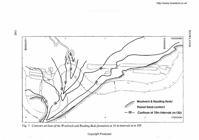
2. The value of such a regionalized approach was relevant to Docklandsbecause it forms a large coherent area which was expected to be completelyredeveloped within a relatively short period. Also, as redevelopment was controlled by a single client, it gave the opportunity to apply a unified set of standardsand made it possible to devise new techniques and procedures.
Geological setting3. The Docklands area lies on part of the flood plain of the River Thames
withinthe geological province of the London Basin. This is an open synclinal foldin Cretaceous and younger rocks plunging gently eastwards. It is one of a suite ofrelatively gently folded structures found across north-west Europe.
4. The London Basin has a geomorphologicalexpression defined by the Chalkdownlands of the Chilterns and the North Downs to the north and south respec-
Ordinary meeting 5.30 p.m., 3 March 1992. Written discussion closes 18 March 1992; forfurther details see p. ii.*A. F. Howland Associates, Norwich.
1153
http://www.howland.co.uk
Copyright Protected

'"""'"'"""'"Ul,J::..
eSt Albans
«!tReading
L 1Km I
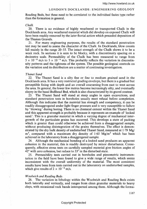
Fig. 1. London's Docklands
o
Chelmsford
Maidstone·! 20Km I
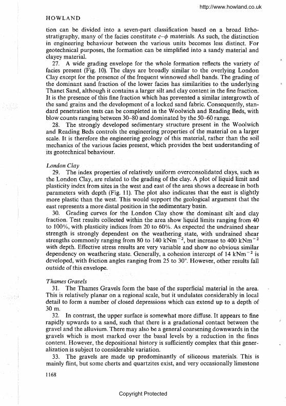
GREENWICH
N
D
BECKTON
R. THA MES
~o~~
>Zo
http://www.howland.co.uk
Copyright Protected
LONDON'S DOCKLANDS: ENGINEERING GEOLOGY
Palaeogene
UpperCretaceouslowerCretaceous
t=EE:EEE Jurassic
• London Basin••- synclinal axis
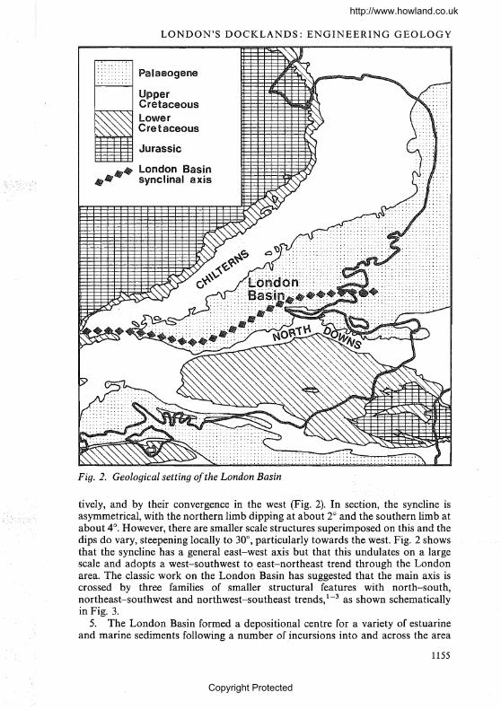
Fig. 2. Geological setting ofthe London Basin
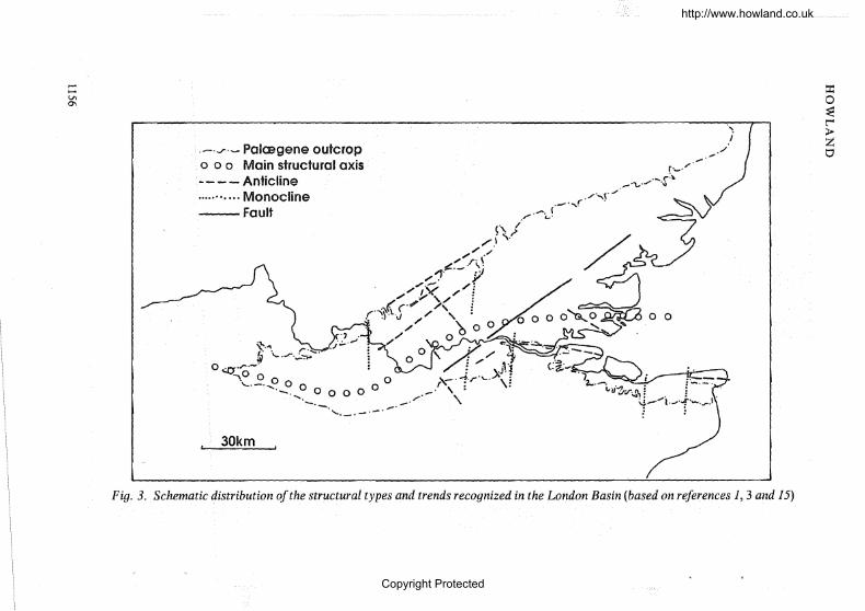
tively, and by their convergence in the west (Fig. 2). In section, the syncline isasymmetrical, with the northern limb dipping at about 2° and the southern limb atabout 4°. However, there are smaller scale structures superimposed on this and thedips do vary, steepening locally to 30°, particularly towards the west. Fig. 2 showsthat the syncline has a general east-west axis but that this undulates on a largescale and adopts a west-southwest to, east-northeast trend through the Londonarea. The classic work on the London Basin has suggested that the main axis iscrossed by three families of smaller structural features with north-south,northeast-southwest and northwest-southeast trends,1-3 as shown schematicallyin Fig. 3.
5. The London Basin formed a depositional centre for a variety of estuarineand marine sediments following a number of incursions into and across the area
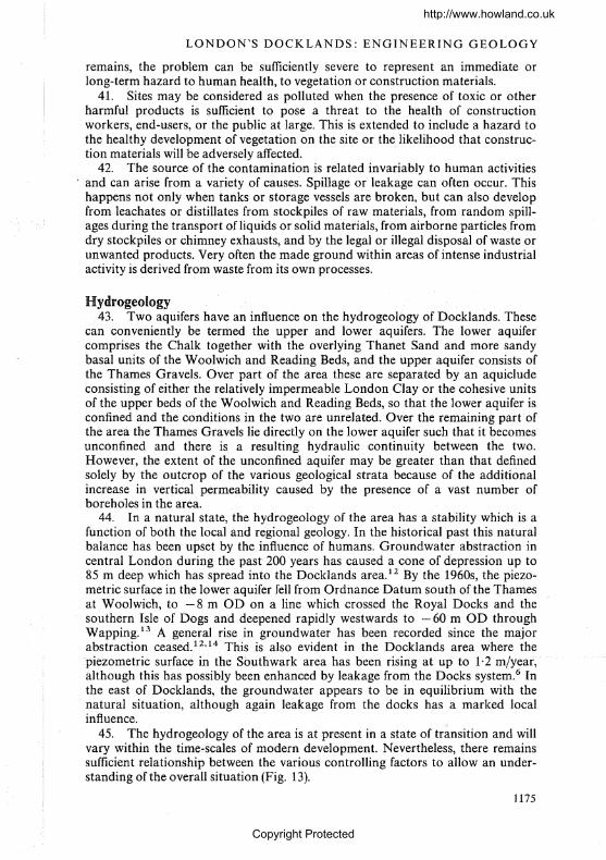
1155
http://www.howland.co.uk
Copyright Protected
~......tA0\
.-.'/'- Palaegene outcropo 0 0 Main structural axis- - - - Anticline........... Monocline--Fault
't.",\,.. ..r.S:-~'=.;g 0o .r·- 0
~,o 0 0 0 0 0 0 0 0 /~._.,._,. --'-',._.- -
, 30km .
r·.....·/.-.".......... -.~.\,
" .~
-z...·_t,iI·~.r..~\d ""l ,j..'-..,..J"1...... .~ ~
"
i./
=r:o~t""4:>Zo
Fig. 3. Schematic distribution ofthe structural types and trends recognized in the London Basin (based on references 1, 3 and 15)
http://www.howland.co.uk
Copyright Protected
LONDON'S DOCKLANDS: ENGINEERING GEOLOGY
Table 1. Geological succession in south-east England
Era Period Epoch FormationAge:Ma
HaloceneQuaternary 0·01
Pleistocene1·8
PlioceneNeogene 5·0
Miocene
u 22·5'0 OligoceneN0 37·5c
Om > Headon Bedsu (ijBarton Beds.~
l1) Eocene Bracklesham Beds.... PalaeogeneBagshot BedsLondon Clay
53·5Blackheath Beds
Palaeocene Woolwichand Reading BedsThanet Sand
65·0
Upper ChalkUpper Cretaceous Middle Chalk
u Lower Chalk'0 93·0N0 Upper Greensand/GaultNQ) Lower Cretaceous Lower Greensand~
Wealden Beds135·0
Jurassic
by the sea throughout the Palaeogene (Table 1). These sediments now largely formthe near surface geology of the Basin.
Geology of Docklands
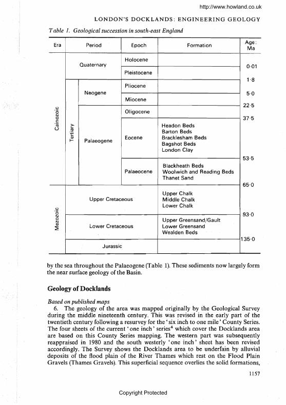
Based on published maps6. The. geology of the area was mapped originally by the Geological Survey
during the middle nineteenth century. This was revised in the early part of thetwentieth century following a resurvey for the 'six inch to one mile' County Series.The four sheets of the current' one inch' series4 which cover the Docklands areaare based on this County Series mapping. The western part was subsequentlyreappraised in 1980 and the south westerly' one inch' sheet has been revisedaccordingly. The Survey shows the Docklands area to be undertain by alluvialdeposits of the flood plain of the River Thames which rest on the Flood PlainGravels (Thames Gravels). This superficial sequence overlies the solid formations,
1157
http://www.howland.co.uk
Copyright Protected
London Clay
Woolwich at Reading Beds
Thanat Sand
::r:o~re>ZC1
178000N
182000N0'1~
~
o
Fault
Chalk+
+
om
\\ _... -'.~.-::.(..'?-::{::"(\\N\C'"'fau~.--. ...:: ::.:....•.
Gt'e~_-'- .-.---- ::.:.--- ... :.,'. ::::
BASED ON G-INCH
'COUNTY SERIES'
REVISED
1980
++01W~
ooom
~
~
V'I00
Fig. 4~ Distribution ofsolid geological formation in Docklands area based on published nlaps by BGS (after reference 4)
http://www.howland.co.uk
Copyright Protected

LONDON'S DOCKLANDS: ENGINEERING GEOLOGY
which in the area comprise Chalk, Thanet Sand, the Woolwich and Reading Bedsand the London Clay. The solid formations are shown by the maps to be intersected by a fault with a northeast-southwest trend, commonly referred to as theGreenwich Fault (Fig. 4).
Revisionfollowing the regional appraisal7. The availability of some 4500 borehole records collated by the LODC in the
Docklands area has allowed a review of the distribution of the principal geologicalunits (Fig. 5). This has shown a broad agreement with the published mapping ofthe British Geological Survey, apart from a revision to the subcrop of the ThanetSand and the fact that the Greenwich Fault does not appear to cross the area.
8. A .lack .of evidence for the presence of the Greenwich Fault, or any othermajor structural dislocation, in the area affects not only the geology along thepreviously postulated fault line but also the structural implications for the region.The Survey shows the Greenwich Fault truncating the Thanet Sand outcropwhere it crosses the Royal Docks to produce a faulted contact with the Woolwichand Reading Beds (Fig. 4). Further to the south east, the Chalk is mapped to bethrown against the Woolwich and Reading Beds. This requires a minimum verti..cal displacement equivalent to the thickness of the intervening Thanet Sand, whichis about 16 m. Without the presence of a fault, it would be necessary to postulatethe local absence of the Thanet Sand. However, the stratigraphy of thePalaeogene5 indicates that the Thanet Sand is a persistent formation. This hasbeen confirmed in the Docklands area,6 hence any local absence is unlikely.Although no work has been undertaken directly for the LDDC south of theThames in this area, a review of other available borehole information indicatesthat the Thanet Sand is present to the south of the river. It seems, therefore, that
. the outcrop of the Thanet Sand extends further to the south west than is shown onthe current geological maps of the British Geological Survey, crossing the Thamesimmediately west of the Thames Barrier site and extending into Greenwich. It isnot therefore necessary to postulate the fault to account for the local absence ofThanet Sand.
9. Without the Greenwich Fault, the dominant structural feature in the areabecomes a· north plunging syncline. The feature is evident in the form of theLondon Clay subcrop shown on the current geological maps of the Survey. Thishas been more closely defined by the new data, and for easy reference is referred toas the Greenwich Syncline.
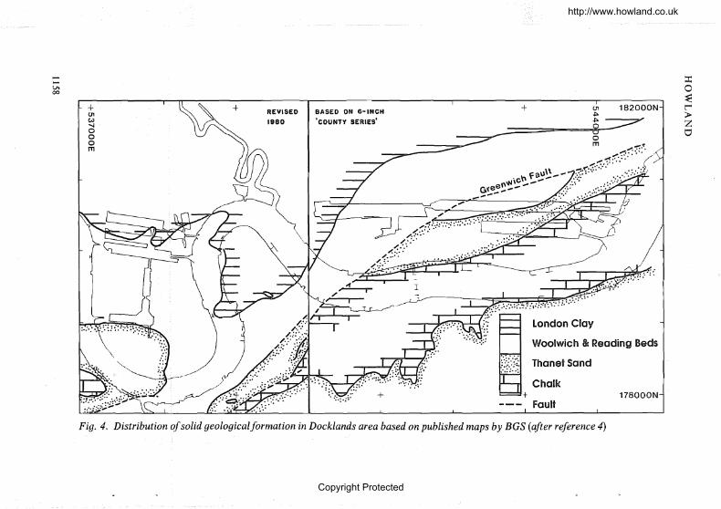
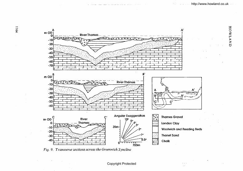
10. Detailed mapping of the Greenwich Syncline shows a north-northeast tosouth~southwestaxis, crossing Docklands from Greenwich. It plunges northwardsto cross the mouth of the River Lea at about is confluence with the Thames.Contouring of the base of each of the formations has shown this to be a relativelyshallow feature (Figs 6-9). In general, the eastern limb dips at about 2°~ with anortheast-southwest strike, and the western limb at about 0'5°. There is evidenceof some minor folding with a complementary northwest-southeast trend, particularly on its east limb. No complementary features ofa similar scale are present inthe mapped area, although low amplitude anticlinal features exist to both the eastand the west, and these have been termed the Beckton Anticline and the MillwallAnticline respectively (Fig. 5). Both of these complementary structures are confused by the smaller scale features on the limb of the Greenwich Syncline, and theyrequire further definition as more data are collected.
1159
http://www.howland.co.uk
Copyright Protected
Fig. 6. Contours on the base ofthe London Clayformation at 10 m intervals in m OD
tI1ZoI--C
Zt'Ijt'Ij
itlI--C
ZootI1ot"""oo~
l4oztjoZt:IJ
oon~l4;>Ztj00
178000N
182000N
t
~London Clay/Woolwich &
Reading Beds contact
- -40 _.. - Contours at 10m intervals (m OD)
I
+
+
+
+
'~_/
+
+U1eN~
ooom
......I--"0\,...
http://www.howland.co.uk
Copyright Protected
--20- Contours at lOm intervals Cm OD)
::r:o~~
>Zo
178000N
182000N
+
Woolwich It Reading Beds/
Thanet Sand contact/ ......: .
.; ....
/
~ /
I - /-~-y/
+
+
+
.. ::.:.::...
..' ....::.:;....,.:..:::~ :.'+
+OlW~
ooom
.......
.......0\N
Fig. 7. Contours onbase ofthe Woolwich and Reading Bedsformatiol1 at 10 m intervals in nz OD
http://www.howland.co.uk
Copyright Protected

Fig. 8. Contours on base ofthe Thanet Sandformation at 10 m intervals in m OD
~ Thanat Sond/Chalk contact
....... ·30- Contours at IOm intervals (m OD)
............0\w
+01W-....Iooom
+
+ +
+ +
182000N
J
178000N
~
ozooZr.noon~~;l>Zot:I'l
t'rlZCl""""4
Zt'rlt'rl~""""4
ZC)
C)t'rlo~
oC)~
http://www.howland.co.uk
Copyright Protected
10-0\10-0\0\~
AI
A _ __ _ __-_~~~_;:m o~l~iverThames::::.;:-_-::: ;;;:: -:0--:' :-;;:: -:0. -..-.,. ..Q.-
=o~t-4>Zt1
Thames Gravel
London Clay
Woolwich and Reading Beds
Thanat Sand
Chalk
gerationAngular Exag
~10" 5°4°30
35m~ ~;.50
C"
700m
Fig. 9. Transverse sections across the Greenwich Syncline
http://www.howland.co.uk
Copyright Protected
LONDON'S DOCKLANDS: ENGINEERING GEOLOGY
Solid deposits
11. Chalk. Water-well records from the area show that the Chalk is approximately 200 m thick, with the Upper Chalk present in the highest levels. Chalk is aweak limestone characterized by a whiteness and purity. A sedimentary structureexists in the Chalk on both a macro-and micro-scale, which in the Middle andUpper Chalk is often picked out by tabular or nodular concretions of flint.
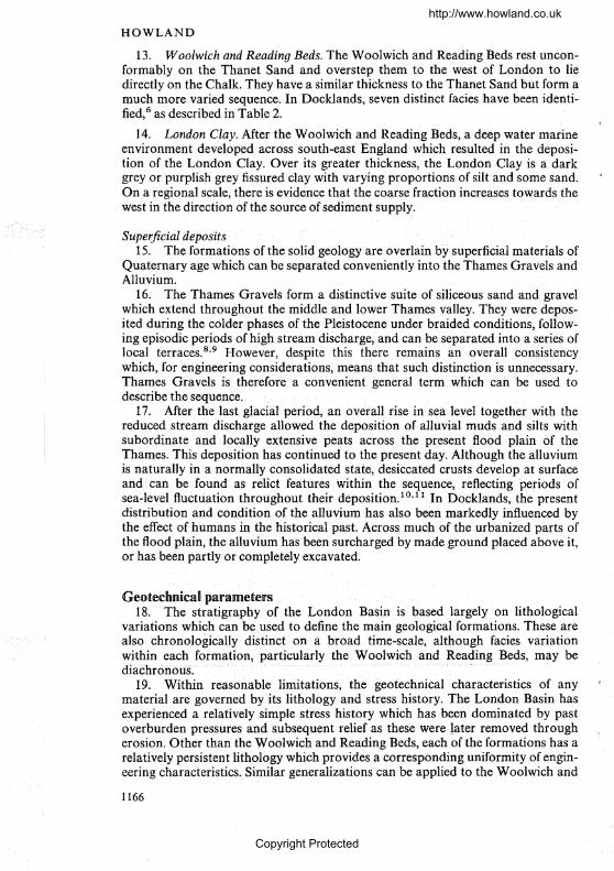
12. Thanet Sand. The Thanet Sand is the youngest of the Palaeogene sediments which infill the London Basin. It lies unconformably on the Chalk, and isabout 16 ID thick in Docklands. In an unweathered state, the Thanet Sand has anoticeable green colour, owing to the presence of the mineral glauconite, but onweathering, it changes to a pale yellow brown. It comprises a quartz sand overmost of its thickness, although minor fractions of clay are found, and occasionalthin clay laminae are present. The basal layer of the Thanet Sand is called theBullhead Bed and is characterized by dark-green rounded flint pebbles in a siltyclay matrix.
Table 2. Description offacies present in W oolwich and Reading Beds in Docldandsarea
Bed Description
h This is an impersistent bed of sands and well-rounded flint gravels, sometimes with aclay content and often containing shell debris. It can be locally cemented and liesirregularly on the lower facies. It is usually no greater than O' 5 m in thickness.
g This is a light blue-grey unfossiliferous clay which lies above Bed e to the west of thearea.
f This isa greenish-grey silty fine sand. It is more persistent than the underlying bedsbut is found only to the east of the area and partly replaces Bed e.
e This is a grey shelly clay with bands of both intact shells and broken, oftenwinnowed shell debris. In the west of the area the bed becomes lessJossiliferous inthe upper part where it contains partings and laminations of silt arid occasionallyfine sand which can develop into rnore prominent sand units ofahout O'5 mthickness. Here, the upper contact is marked by an organic horizon.
c This is a distinctive variously coloured clay, often veryIuottled with a gradationalcontact from Bed b. It is associated with a buff or pale~ctearnlixnestone,·usually ina single horizon, occasionally two bands maybe present. The limestone varies inthickness and although it has been recorded as being a metre or so, it is morecommonly only a fraction of this. The limestone may appear as nodules orconcretions. Where it is more persistent, it is often weathered and reduces inhardness with depth and can be very rubbly or poorly developed in its lowerparts.
b Thisis a persistetlt clayey sand, green or green-grey with a blue-greymottling. Itoften appears to have very little sedimentological structure, although some claypartings and lenses have been noted. The clay content can be sufficient to make itcohesive, even though its grain size is dominated by a fine to medium sand sizefraction. The fines content increases downwards through the bed. It containssome gravel which can be similar to Bed arnaterial. Gravel becomes commontowards the west of the area, noticeably from the Lea confluence. It is commonlyabout 2-4 m in thickness.
a This is sandy clay, typically dark grey~green,with a varying gravc:;l content which inplaces dominates the grading. The gravels are well-rounded, dark green or blackin colour. It varies in thickness, but is usually less than a metre and often muchless.
1165
http://www.howland.co.uk
Copyright Protected
HOWLAND
13. Woolwich and Reading Beds. The Woolwich and Reading Beds restunconformably on the Thanet Sand and overstep them to the west of London to liedirectly on the Chalk. They have a similar thickness to the Thanet Sand but form amuch more varied sequence. In Docklands, seven distinct facies have been identified, 6 as described in Table 2.
14. London Clay. After the Woolwich and Reading Beds, a deep water marineenvironment developed across south-east England which resulted in the deposition of the London Clay. Over its greater thickness, the London Clay is a darkgrey or purplish grey fissured clay with varying proportions of silt and some sand.On a regional scale, there is evidence that the coarse fraction increases towards thewest in the direction of the source of sediment supply.
Super.ficial deposits15. The formations of the solid geology are overlain by superficial materials of
Quaternary age which can be separated conveniently into the Thames Gravels andAlluvium.
16. The Thames Gravels form a distinctive suite of siliceous sand and gravelwhich extend throughout the middle and lower Thames valley. They were deposited during the colder phases of the Pleistocene under braided conditions, following episodic periods of high stream discharge, and can be separated into a series oflocal terraces. 8
,9 However, despite this there remains an overall consistencywhich, for engineering considerations, means that such distinction is unnecessary.Thames Gravels is therefore a convenient general term which caribe used todescribe the sequence.
17. After the last glacial period, an overall rise in sea level together with thereduced stream discharge allowed the deposition of alluvial muds and silts withsubordinate and locally extensive peats across the present flood plain of theThames. This deposition has continued to the present day. Although the alluviumis naturally in a normally consolidated state, desiccated crusts develop at surfaceand can be found as relict features within the sequence, reflecting periods ofsea-level fluctuation throughout their deposition. 1
0,11 In Docklands, the presentdistribution and condition of the alluvium has also been markedly influenced bythe effect of humans in the historical past. Across much of the urbanized parts ofthe flood plain, the alluvium has been surcharged by made ground placed above it,or has been partly or completely excavated.
Geotechnical parameters18. The stratigraphy of the London Basin is based largely on lithological
variations which can be used to define the main geological formations. These arealso chronologically distinct on a broad time-scale, although facies variationwithin each formation, particularly the Woolwich and Reading Beds, may bediachroI1oiIs. ... .....
19. Within reasonable limitations, the geotechnical characteristics of anymaterial are governed by its lithology and stress history. The London Basin hasexperienced a relatively simple stress history which has been dominated by pastoverburden pressures and subsequent relief as these were later removed througherosion. Other than the Woolwich and Reading Beds, each of the formations has arelatively persistent lithology which provides a corresponding uniformity of engineering characteristics. Similar generalizations can be applied to the Woolwich and
1166
http://www.howland.co.uk
Copyright Protected
LONDON'S DOCKLANDS: ENGINEERING GEOLOGY
Reading Beds, but these need to be correlated to the individual facies type ratherthan the formation in general.
Chalk20. There is no evidence of highly weathered or transported Chalk in the
Docklands area. Any weathered material which did develop on exposed Chalk willhave bee,n readily removed by the later fluvial action which preceded deposition ofthe Thames Gravels.
21. For many engineering purposes, the results of the standard penetrationtest may be used to assess the character of the Chalk. In Docklands, blow countsfall mainly in the range 20-55. The intact strength of the Chalk shows it to be aweak rock. In sections. it is seen to be blocky, with· a discontinuity spacing on adecimetre scale. Permeability of the Chalk has been measured to range from5 x 10- 8 rn/sto 5 x 10- 4 m/so This probably reflects the variation in discontinuity patterns and the tightness of the system. The possible geological controls onthe variation and its distribution are a matter of continuing investigation.
ThanetSand22. The Thanet Sand is a silty fine or fine to medium grained sand in the
Docklands area. It has a very restricted grading envelope, but there is a gradual butperceptible fining with depth and an overall coarsening from east to west acrossthe area. In general, the lower few metres become increasingly silty, and eventuallyclayey in the basal Bullhead Bed, which is also characterized by its gravel content.
23. The Thanet Sand will stand at steep angles in open excavations, andstandard penetration tests in boreholes usually meet refusal before completion.Although this indicates that the material has strength and competency, it can bereadily dissaggregated under light finger pressure and is very susceptible to failureby 'blowing' during boring. There is no chemical cement within the Thanet Sandand this apparent strength is probably because it represents an example of' lockedsand '. This is a granular material in which a varying degree of mechanical· intergrowth of. the. particulate grains has occurred. This develops a state of packingwhich is greater than could otherwise be achieved from a disaggregated sample,without producing disintegration of the grains themselves. The effect is demonstrated by the dry bulk density of undisturbed Thanet Sand, measured at 1·79 Mgjm 3
, compared with a maximum dry density of 1·65 Mg/m3 which has beenachieved in the laboratory from a disaggregated sample.
24. Although the mechanical bonding of a locked sand produces an apparentcohesion in the material, this is readily destroyed by minor disturbance. Consequently, effective stress tests on carefully sampled material give friction angles of42° with zero cohesion, but reduce to 33° in the disturbed state.
25. Permeability tests carried out in boreholes and piezometric instrumentation in the field have been found to give a wide range of results, which seemsinconsistent with the overall uniformity of the material. The most consistentresults have been from tests carried out in the laboratory on undisturbed samples,which give results of2 x 10- 6 rn/s.
W oolwich and Reading Beds26. The variation in lithology within the Woolwich and Reading Beds exists
both laterally and vertically, and ranges from clean granular materials to heavyclays, with occasional rock bands interspersed among them. Although the forma-
1167
http://www.howland.co.uk
Copyright Protected
HOWLAND
tion can be divided into a seven-part classification based on a broad lithostratigraphy, many of the facies constitute c-4> materials. As such, the distinctionin engineering behaviour between the various units becomes less distinct. Forgeotechnical purposes, the formation can be simplified into a sandy material andclayey material.
27. A wide grading envelope for the whole formation reflects the variety offacies present (Fig. 10). The clays are broadly similar to the overlying LondonClay except for the presence of the frequent winnowed shell bands. The grading ofthe dominant sand fraction of the lower facies has similarities to the underlyingThanet Sand, although it contains a larger silt and clay content in the fine fraction.It is the presence of this fine fraction which has prevented a similar intergrowth ofthe sand grains and the development of a locked sand fabric. Consequently, standard penetration tests can be completed in the Woolwich and Reading Beds, withblow counts ranging between 3D-SO and dominated by the 50-60 range.
2S. The strongly. developed sedimentary structure present "in the Woolwichand Reading Beds controls the engineering properties of the material on a largerscale. It is therefore the engineering geology of this material, rather than the soilmechanics of the various facies present, which provides the best understanding of,its geotechnical behaviour.
London Clay29. The index properties of relatively uniform overconsolidated clays, such as
the London Clay, are related to the grading of the clay. A plot of liquid limit andplasticity index from sites in the west and east of the area shows a decrease in bothparameters with depth (Fig. 11). The plot also indicates that the east is slightlymore plastic than the west. This would support the geological argument that theeast represents a more distal position in the sedimentary basin.
30. Grading curves for the London Clay show the dominant silt" and clayfraction. Test results collected within the area show liquid limits ranging from 40to 100%, with plasticity indices from 20 to 60°;{). As expected the undrained shearstrength is strongly dependent on the weathering state, with undrained shearstrengths commonly ranging from 80 to 140 kNm -2, but increase to 400 kNm- 2
with depth. Effective stress results are very variable and show no obvious similardependency on weathering state. Generally, a cohesion intercept of 14 kNm -2 isdeveloped, with friction angles ranging from 25 to 30°. However, other results falloutside of this envelope.
Thames Gravels31. The Thames Gravels form the base of the superficial material in the area.
This is relatively planar ona regional scale, but it undulates considerably in localdetail to form a number of closed depressions which can extend up to a depth of30 m.
32. In contrast, the upper surface is somewhat more diffuse. Itappears to finerapidly upwards to a sand, such that there is a gradational contact between thegravel and the alluvium. There may also be a general coarsening downwards in thegravels which is most marked over the basal levels by a reduction in the finescontent. However, the depositional history is sufficiently complex that this generalization is subject to considerable variation.
33. The gravels are made up predominantly of siliceous materials. This ismainly flint, but some cherts and quartzites exist, and very occasionally limestone
1168
http://www.howland.co.uk
Copyright Protected

LONDON'S DOCKLANDS: ENGINEERING GEOLOGY
has been found which appears to have been derived locally from the Woolwichand Reading Beds. Very occasionally, the gravels are found to be cemented withan iron oxide, but typically they are in a medium dense condition, with standardpenetration tests giving results ranging from 10 to 35.
34. The material is graded from fine sand to coarse gravel and occasionally upto cobble size. Only rarely is any clay found, and then usually as a distinct band orlens. Although there is a wide range in DIO and D60 for the gravels, when plottedagainst each other (Fig. 12) there is a very marked linearity in the relationship overmuch of the range, such that
D60 = (DID - 0.294)0'0042- 1
35. Permeability tests have been found to give very variable results in theThames Gravels. Although permeability can be expected to be controlled by theprecise grading and other local sedimentological structures, the results often showan unacceptable range, even when closely supervised. Large-scale pumping testshave proved a more reliable method of assessment and have given results of10- 3-10- 4 m/so
Alluvium36. The alluvium comprises peats, and a group of clays and siltyclays with a
varying organic content which often contains peaty inclusions. The present condition and distribution of the alluvium has been affected greatly by the developmentof the area and it does not therefore conform readily to an anticipated normallyconsolidated material.
37. Atterberg limits of the clays fall around the A-line, reflecting the variableorganic content. These contrast with those of the peats which fall mainly below theA-line. Undrained shear strengths vary typically from 5 to 45 kNm - 2.
Made ground38. Much of the area of Docklands is convered by made ground. It varies in
thickness from less than 1 m to more than 10 m, but is most commonly between2-3 m. Its greatest thickness occurs as infill to former docks, although it also has asubstantial thickness adjacent to the river, where the ground has been made upover historical time to provide an increasing deep water frontage and protectionagainst flooding.
39. Over much of the area of former docks, the made ground comprises adiverse mix of sands, gravels and clays derived from the excavation of the docks.Elsewhere, the made ground comprises thicknesses of demolition rubble and othermaterials from the activities of former industrial activities. Although various docksand related structures have been infilled or demolished, this has been to varyingstandards. Substructures were rarely removed so that buried structures and services are also present. The made ground is therefore the most random of thedeposits in the area.
Contamination40. The previous use of much of the land within Docklands for industrial
purposes means that it is potentially contaminated by chemical pollution. Theeffects of industrial contamination are usually permanent, or at least very longlived, so that even where no evidence of the original cause of the contamination
1169
http://www.howland.co.uk
Copyright Protected
HOWLAND
\\
\\
\
IIIGU(/)1--11-
,"
".
\\\\\\.
" .............
..................... ........
..............\ ,\ ,
""
"
"
" ,"
"
"
" ,""
........
\\\\\
""'\\
"
1170
http://www.howland.co.uk
Copyright Protected
~
0Z00ZCZl
00(')
~~
>Zt'CZl..tr.1Z0~
ZL'T1m~
mm ~
ZC)
Qm0t""400~
100
WRS
hfe,9ca,b
./
100.10.01
-,;::::;::.- ,--~~ ......... ,....:;):~1 it" /"-"-"
/' ,: /"/1 if"/' / 1...__---/ / +--1'I A! j! //! /
~' /",/
" / !f !" /: // I / I! :
"" J ,. I./"" / / /j j
./ """", // :/" .......... /" I"......" ~/.i j............. :/ I
~~ "'~'./~~ .' /
CLAY
Fig. 1O(b). Grading envelopes for mainfacies of W oolwich and Reading Beds (WRB)
0.001
........
:i........
http://www.howland.co.uk
Copyright Protected

A-"'V VV LAND
+ LL
o PI
+I
+14
20
18
16
~[jc 12o-0Co
....J
aID(/)co-0ID>o.0eel(/)Q)
~ 8:2
0"---------.1.----------o 50 100Percent
(a)
Fig. 11 (above and facing). Liquid limit (LL) and plasticity index (PI) for London~lay plotted against metres above its stratigraphic base from: (a) west of area; (b)ast ofarea
72
http://www.howland.co.uk
Copyright Protected

LONDON'S DOCKLANDS: ENGINEERING GEOLOGY
20
o18
16
14
>.et!Uc 120"CC0
...J
15Q)Cl)
10co.0Q)
>0.0coCl)
~Q) 8~
6
4
2
10050Percent
(b)
O'-------,.----,._------,.--L.------,.-----,.----,..,---------I
o
Fig. ll-continued
1173
http://www.howland.co.uk
Copyright Protected

HOWLAND
Grading: D1 0: mm
0·8 1·2
4
6
8
EEoCD
C 10enc::ccc(5
12
4H
16
18
20
+ +
t
•
1·6
+ + +
• +
2·0
Fig. 12. D10 plotted against D60for Thames Gravels
1174
http://www.howland.co.uk
Copyright Protected
LONDON'S DOCKLANDS: ENGINEERING GEOLOGY
remains, the problem can be sufficiently severe to represent an immediate orlong-term hazard to human health, to vegetation or construction materials.
41. Sites may be considered as polluted when the presence of toxic or otherharmful products is sufficient to pose a threat to the health of constructionworkers, end-users, or the public at large. This is extended to include a hazard tothe healthy development of vegetation on the site or the likelihood that construction materials will be adversely affected.
42. The source of the contamination is related invariably to human activities. and can arise from a variety of causes. Spillage or leakage can often occur. This
happens not only when tanks or storage vessels are broken, but can also developfrom leachates or distillates from stockpiles of raw materials, from random spillages during the transport of liquids or solid materials, from airborne particles fromdry stockpiles or chimney exhausts, and by the legal or illegal disposal of waste orunwanted products. Very often the made ground within areas of intense industrialactivity is derived from waste from its own processes.
Hydrogeology43. Two aquifers have an influence on the hydrogeology of Docklands. These
can conveniently be termed the upper and lower aquifers. The lower aquifercomprises the Chalk together with the overlying Thanet Sand and more sandybasal units of the Woolwich and Reading Beds, and the upper aquifer consists ofthe Thames Gravels. Over part of the area these are separated by an aquicludeconsisting of either the relatively impermeable London Clay or the cohesive unitsof the upper beds of the Woolwich and Reading Beds, so that the lower aquifer isconfined and the conditions in the two are unrelated. Over the remaining part ofthe area the Thames Gravels lie directly on the lower aquifer such that it becomesunconfined and there is a resulting hydraulic continuity between the two.However, the extent of the unconfined aquifer may be greater than that definedsolely by the outcrop of the various geological strata because of the additionalincrease in vertical permeability caused by the presence of a vast number ofboreholes in the area.
44. In a natural state, the hydrogeology of the area has a stability which is afunction of both the local and regional geology. In the historical past this naturalbalance has been upset by the influence of humans. Groundwater abstraction incentral London during the past 200 years has caused a cone of depression up to85 m deep which has spread into the Docklands area. 12 By the 1960s, the piezometric surface in the lower aquifer fell from Ordnance Datum south of the Thamesat Woolwich, to -8 m OD on a line which crossed the Royal Docks and thesouthern Isle of Dogs and deepened rapidly westwards to - 60m OD throughWapping. 13 A general rise in groundwater has been recorded since the majorabstraction ceased. 12,14 This is also evident in the Docklands area where thepiezometric surface in the SOuthwark area has been rising at up to 1·2 m/yea.r,although this has possibly been enhanced by leakage from the Docks system.6 Inthe east of Docklands, the groundwater appears to be in equilibrium with thenatural situation, although again leakage from the docks has a marked localinfluence.
45. The hydrogeology of the area is at present in a state of transition and willvary within the time-scales of modern development. Nevertheless, there remainssufficient relationship between the various controlling factors to allow an understanding of the overall situation (Fig. 13).
1175
http://www.howland.co.uk
Copyright Protected
:r:o~~
>ZtJ
-."..-~.",.-.,.,.
("--~Lower i aquifer
Artesion
S well
'" .. .. __---~-------------.-------Jl--(f-. T ..~ ' .. ..:.~Tham~.s~ . . Aqljlclude_,~. 5;:···· . I...., ....: .. Upper aquifer :<:" /
;...4
~0'\
""
,,'"
/r'"Fig. 13. Schematic east-west section through part of Docklands showing the effect of historical groundwater abstraction in centralLondon and the relationship between piezometric levels in the lower and upper aquifer
http://www.howland.co.uk
Copyright Protected
LONDON'S DOCK LANDS : ENGINEERING GEOLOGY
Conclusions46. The stratigraphy of the Docklands area is based largely on lithological
changes. These can be correlated with their geotechnical characteristics which aregoverned by the lithology land stress history. An appreciation of the regionalgeology and its associated geotechnical conditions improves the understanding ofany site specific data.
47. The need to understand the relevant geology and hydrogeology has been aprerequisite to the role of engineering geology in the renewal programme ofLondon Docklands. A systematic collection and evaluation of information haveallowed the necessary models to be developed, and have improved the engineeringgeological understanding of the area. This approach has had advantages in evaluating further information as it is collected during the course of engineering pro-
. jects, to provide an assessment of the reliability of the data or give an earlyindication of anomalous results. It has also aided the rapid response by the LDDCto development proposals generated through the renewal process.
48. The evaluation is by no means complete and every new borehole adds tothe understanding and will assist the continuing development of the area. A rolefor engineering geology as a central function has been demonstrated in the newdiscipline of urban renewal.
Acknowledgements49. I am indebted to the London Docklands Development Corporation for
permission to incorporate work undertaken for them in this Paper, and in particular to Bob Blyth, Bill Conchie and David Crompton, past and present officers ofthe LDDC, who have allowed and encouraged the general approach to be formulated within the civil engineering section.
References1. WOOLDRIDGE S. W. The minor structures of the London Basin. Proc. Geologists Ass.,
1923,34, 175-190.2. WOOLDRIDGE S. W. The structural evolution of the London Basin. Proc. Geologists Ass.,
1926, 37, 162-196.3. WOOLDRIDGE S. W. and LINTON D. L. Structure, surface and drainage in south-east
England. George Philip, London, 1955.4. BRITISH GEOLOGICAL SURVEY. Geological maps ofEngland and Wales: Sheets 256 (North
London), 257 (Romford), 270 (South London) and 271 (Dartford). Ordnance Survey,Southampton.
5." CURRY D.et al. A correlation ofthe Tertiary rocks in the British Isles. Geological Societyof London, 1978, Special Report 12.
6. HOWLAND A. F. An engineering geology database for urban renewal. University ofLondon, 1989, PhD thesis, unpublished.
7. SHERLOCK R. L. British regional geology: London and Thames Valley. HMSO, London,1960.
8. GIBBARD P. L. Pleistocene history of the Middle Thames Valley. Cambridge UniversityPress, Cambridge, 1985.
9. BRIDGLAND D. R. The Pleistocene fluvial stratigraphy and palaeogeography of Essex.Proc. Geologists Ass., 1988,99, (4),291-314.
10. HAWKINS A. B. et al. Selecting the location, and the initial investigation of the SERC softclay test bed site. Q. JI EngngGeology, 1989,22, (4), 281-316.
11. DEVOY R. J. N. Flandrian sea level changes and vegetational history of the lower ThamesEstuary. Philosophical Trans. R. Soc., Lond., 1977,2858,355-407.
1177
http://www.howland.co.uk
Copyright Protected

HOWLAND
12. CONSTRUCTION INDUSTRY RESEARCH AND INFORMATION ASSOCIATION. The engineeringimplications of rising groundwater levels in the deep aquifer beneath London. CIRIA,
London, 1989.13. WATER RESOURCES BOARD. The hydrogeology of the London Basin with special reference
to artificial recharge. Water Resources Board, Reading, 1972.14. MARSH T. J. and DAVIES P. A. The decline and partial recovery of groundwater levels
below London. PI'OC. Instn Civ. Engrs, 1983, 74, May, 263-276.15. IONES D. K. C. The geomorpltology of the British Isles: southeast and sOllthern England.
Methuen, London, 1981.
1178
http://www.howland.co.uk
Copyright Protected