London Boroughs of Wandsworth, Merton, Sutton...
74
Prepared for London Boroughs of Wandsworth, Merton, Sutton and Croydon Strategic Flood Risk Assessment Level 1 Final Report December 2008
-
Upload
truongdung -
Category
Documents
-
view
217 -
download
0
Transcript of London Boroughs of Wandsworth, Merton, Sutton...
Prepared for
London Boroughs of Wandsworth, Merton, Sutton and Croydon
Strategic Flood Risk Assessment Level 1 Final Report December 2008
London Boroughs of Wandsworth, Merton, Sutton and Croydon Level 1 Strategic Flood Risk Assessment
Scott Wilson 6 – 8 Greencoat Place London SW1P 1PL Tel +44(0)20 7798 5000 Fax +44(0)20 7798 5001 www.scottwilson.com
This document has been prepared in accordance with the scope of Scott Wilson's appointment with its client and is subject to the terms of that appointment. It is addressed to and for the sole and confidential use and reliance of Scott Wilson's client. Scott Wilson accepts no liability for any use of this document other than by its client and only for the purposes for which it was prepared and provided. No person other than the client may copy (in whole or in part) use or rely on the contents of this document, without the prior written permission of the Company Secretary of Scott Wilson Ltd. Any advice, opinions, or recommendations within this document should be read and relied upon only in the context of the document as a whole. The contents of this document do not provide legal or tax advice or opinion. © Scott Wilson Ltd 2008
Revision Schedule Level 1 Strategic Flood Risk Assessment December 2008
Rev Date Details Prepared by Reviewed by Approved by
00 Dec 2007 Draft Tom Edwards Flood Risk Consultant
Liz Williams Senior Consultant
Jon Robinson Associate Director
01 May 2008 Final Draft Tom Edwards Flood Risk Consultant
Jon Robinson Associate Director
Jon Robinson Associate Director
02 June 2008 Final Nick Martin Flood Risk Engineer Liz Williams Senior Consultant
Jon Robinson Associate Director
Jon Robinson Associate Director
03 July 2008 Final with EA comments
Nick Martin Flood Risk Engineer Tom Edwards Flood Risk Consultant
Liz Williams Principal Consultant
Jon Robinson Associate Director
04 Dec 2008 Final version Tom Edwards Flood Risk Consultant
Liz Williams Principal Consultant
Jon Robinson Associate Director
London Boroughs of Wandsworth, Merton, Sutton and Croydon Level 1 Strategic Flood Risk Assessment
Abbreviations Acronym Definition
AONB Area of Outstanding Natural Beauty
CFMP Catchment Flood Management Plan
CLG Communities and Local Government
DEM Digital Elevation Model
DPD Development Plan Documents
DTLR UK Department of Transport, Local Government and Regions
EA Environment Agency for England and Wales
FRA Flood Risk Assessment
GIS Geographical Information Systems
IDB Internal Drainage Board
LB London Borough
LBC The London Borough of Croydon
LBM The London Borough of Merton
LBS The London Borough of Sutton
LBW The London Borough of Wandsworth
LDDs Local Development Documents
LDF Local Development Framework
LDS Local Development Scheme
LiDAR Light Detection and Ranging
LPA Local Planning Authority
ODPM Office of the Deputy Prime Minister
PCPA 2004 Planning and Compulsory Purchase Act 2004
PPG25 Planning Policy Guidance Note 25: Development and Flood Risk
PPS25 Planning Policy Statement 25: Development and Flood Risk
RFRA Regional Flood Risk Appraisal
RPG Regional Planning Guidance
SAR Synthetic Aperture Radar
SAC Special Area of Conservation
SA Sustainability Appraisal
SFRA Strategic Flood Risk Assessment
SPG Supplementary Planning Guidance
SSSI Site of Special Scientific Interest
SuDS Sustainable Drainage Systems
London Boroughs of Wandsworth, Merton, Sutton and Croydon Level 1 Strategic Flood Risk Assessment
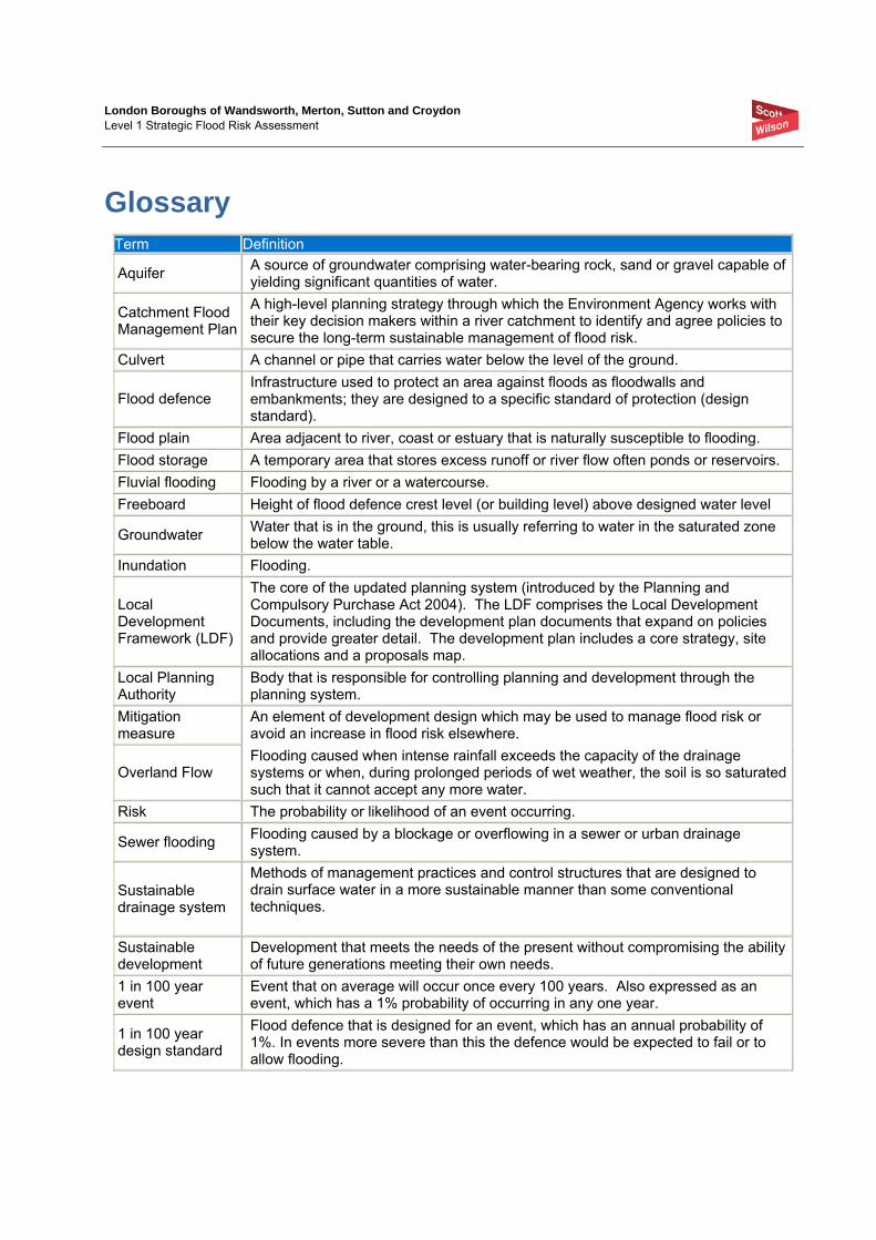
Glossary Term Definition
Aquifer A source of groundwater comprising water-bearing rock, sand or gravel capable of yielding significant quantities of water.
Catchment Flood Management Plan
A high-level planning strategy through which the Environment Agency works with their key decision makers within a river catchment to identify and agree policies to secure the long-term sustainable management of flood risk.
Culvert A channel or pipe that carries water below the level of the ground.
Flood defence Infrastructure used to protect an area against floods as floodwalls and embankments; they are designed to a specific standard of protection (design standard).
Flood plain Area adjacent to river, coast or estuary that is naturally susceptible to flooding. Flood storage A temporary area that stores excess runoff or river flow often ponds or reservoirs. Fluvial flooding Flooding by a river or a watercourse. Freeboard Height of flood defence crest level (or building level) above designed water level
Groundwater Water that is in the ground, this is usually referring to water in the saturated zone below the water table.
Inundation Flooding.
Local Development Framework (LDF)
The core of the updated planning system (introduced by the Planning and Compulsory Purchase Act 2004). The LDF comprises the Local Development Documents, including the development plan documents that expand on policies and provide greater detail. The development plan includes a core strategy, site allocations and a proposals map.
Local Planning Authority
Body that is responsible for controlling planning and development through the planning system.
Mitigation measure
An element of development design which may be used to manage flood risk or avoid an increase in flood risk elsewhere.
Overland Flow Flooding caused when intense rainfall exceeds the capacity of the drainage systems or when, during prolonged periods of wet weather, the soil is so saturated such that it cannot accept any more water.
Risk The probability or likelihood of an event occurring.
Sewer flooding Flooding caused by a blockage or overflowing in a sewer or urban drainage system.
Sustainable drainage system
Methods of management practices and control structures that are designed to drain surface water in a more sustainable manner than some conventional techniques.
Sustainable development
Development that meets the needs of the present without compromising the ability of future generations meeting their own needs.
1 in 100 year event
Event that on average will occur once every 100 years. Also expressed as an event, which has a 1% probability of occurring in any one year.
1 in 100 year design standard
Flood defence that is designed for an event, which has an annual probability of 1%. In events more severe than this the defence would be expected to fail or to allow flooding.
London Boroughs of Wandsworth, Merton, Sutton and Croydon Level 1 Strategic Flood Risk Assessment
Table of Contents 1 Non-Technical Summary.................................................................... 1 1.1 Introduction....................................................................................................................... 1 1.2 SFRA Background............................................................................................................ 1 1.3 SFRA Report Layout ........................................................................................................ 1 1.4 SFRA Planning Objectives ............................................................................................... 2 1.5 Way Forward .................................................................................................................... 3 1.6 A Living Document ........................................................................................................... 3
2 Introduction......................................................................................... 4 2.1 Overview .......................................................................................................................... 4 2.2 Aim of the SFRA............................................................................................................... 4 2.3 SFRA Objectives .............................................................................................................. 4 2.4 SFRA Structure ................................................................................................................ 5
3 The Wandsworth, Merton, Sutton and Croydon SFRA Study Area.................................................................................................... 7
3.1 Local Rivers...................................................................................................................... 7 3.2 Hydrogeology/Groundwater ............................................................................................. 9 3.3 Sewers ............................................................................................................................. 9 3.4 Overland Flow .................................................................................................................. 9 3.5 Surface Water ................................................................................................................ 10 3.6 Artificial Sources............................................................................................................. 10 3.7 History of Flooding in the area ....................................................................................... 10
4 Policy Context .................................................................................. 11 4.1 Introduction..................................................................................................................... 11 4.2 National Policies............................................................................................................. 11 4.3 Regional Policies............................................................................................................ 12 4.4 Local Policies ................................................................................................................. 15 4.5 Environment Agency Policies......................................................................................... 16 4.6 Regional Flood Risk Assessment (RFRA)...................................................................... 17 4.7 Neighbouring Strategic Flood Risk Assessment Status ................................................. 19 4.8 Other Relevant Policies.................................................................................................. 19
5 Data Collection and Review ............................................................. 20 5.1 Project Approach............................................................................................................ 20 5.2 Data Review / Overview ................................................................................................. 21
6 Methodology..................................................................................... 25 6.1 Requirements of PPS25................................................................................................. 25
London Boroughs of Wandsworth, Merton, Sutton and Croydon Level 1 Strategic Flood Risk Assessment
6.2 GIS Layers and Mapping................................................................................................ 25 6.3 Tidal Flooding................................................................................................................. 26 6.4 Fluvial Flooding .............................................................................................................. 28 6.5 Sewer Flooding .............................................................................................................. 30 6.6 Surface Water Flooding / Overland Flow........................................................................ 31 6.7 Groundwater Flooding.................................................................................................... 32 6.8 Artificial Sources / Infrastructure Failure ........................................................................ 33
7 Flood Mapping and Application ........................................................ 34 7.1 Introduction..................................................................................................................... 34 7.2 Flood Zone Mapping ...................................................................................................... 34 7.3 Breach Modelling............................................................................................................ 34 7.4 Depth Mapping ............................................................................................................... 36 7.5 Hazard Mapping ............................................................................................................. 36 7.6 Riverside Topographic Assessment............................................................................... 36 7.7 Summary ........................................................................................................................ 38
8 Guidance on Applying PPS25 Sequential Test ................................ 40 8.1 What is the PPS25 Sequential Test? ............................................................................. 40 8.2 Development Vulnerability Classifications...................................................................... 41 8.3 Undertaking the Sequential Test .................................................................................... 41
9 Guidance on Applying the PPS25 Exception Test ........................... 46 9.1 Why is there an Exception Test?.................................................................................... 46
10 Flood Risk Management................................................................... 48 10.1 Flood Defences .............................................................................................................. 48 10.2 Flood Warning ................................................................................................................ 49 10.3 Residual Risk ................................................................................................................. 50 10.4 Emergency Planning ...................................................................................................... 53
11 Sustainable Drainage Systems ........................................................ 55 11.1 Principles........................................................................................................................ 55 11.2 SuDS Recommendations ............................................................................................... 55 11.3 SuDS Policies................................................................................................................. 57 11.4 Where can SuDS be utilised? ........................................................................................ 57 11.5 London Borough of Wandsworth Summary ................................................................... 58 11.6 London Borough of Merton Summary ............................................................................ 59 11.7 London Borough of Sutton Summary ............................................................................. 59 11.8 London Borough of Croydon Summary.......................................................................... 60 11.9 Planning Considerations for SuDS................................................................................. 61 11.10 Further Information......................................................................................................... 61
London Boroughs of Wandsworth, Merton, Sutton and Croydon Level 1 Strategic Flood Risk Assessment
12 Site Specific FRA Guidance ............................................................. 62 12.1 When is a Flood Risk Assessment Required? ............................................................... 62 12.2 FRA Requirements......................................................................................................... 62
13 Conclusions and Recommendations ................................................ 64 13.1 Summary ........................................................................................................................ 64 13.2 Recommendations ......................................................................................................... 64
14 References ....................................................................................... 66
Appendices.................................................................................................. 67 Appendix A - Figures Appendix B - Local Policy Appendix C - Breach Modelling and Riverside Topographic Analysis Appendix D - Sequential Test Tables and Flood Zone Mapping Appendix E - SuDS Guidance Appendix F - Environment Agency Policy Checklist
Appendix G - Surface Water Flooding Data
London Boroughs of Wandsworth, Merton, Sutton and Croydon Level 1 Strategic Flood Risk Assessment
D116824 – Wandsworth, Merton, Sutton and Croydon SFRA December 2008 1
1 Non-Technical Summary
1.1 Introduction The study area is located in south London and is defined by the administrative boundaries of the London Boroughs of Wandsworth, Merton, Sutton and Croydon.
The study area is heavily urbanised with a higher concentration of recreational parkland areas in the southern Boroughs. The main sources of flooding are the tidal River Thames and fluvial River Wandle, River Graveney, Beverley Brook and Pyl Brook. The River Wandle and its tributaries flow through all four Boroughs before converging with the Thames in Wandsworth.
The River Thames forms the northern boundary of the study area, and provides the dominant flood source on the London Borough of Wandsworth. However taking into account the reported good condition of the Thames Tidal Defences and protection afforded by the Thames Barrier, the tidal floodplain area is considered as being defended.
The main pockets of higher flood risk areas (from rivers) tend to be localised along the main Rivers. Within and around these areas it is important that flood risk management is effectively implemented to ensure future development does not exacerbate existing flood risk.
The southern half of the study area (including the majority of Croydon and Sutton Boroughs) has a localised floodplain from the associated stretches of river, and the main flooding risks to the remaining area would arise from surface, sewer or groundwater flooding. These sources are also considered in this SFRA.
In the recent floods of 2007 all four Boroughs were affected. The flooding incidents were mainly attributed to surface water flooding.
1.2 SFRA Background Scott Wilson Ltd was commissioned by the London Boroughs of Wandsworth, Merton, Croydon and Sutton to undertake a Strategic Flood Risk Assessment (SFRA) of their local authority areas. This project has been carried out in collaboration with the Environment Agency’s Thames Region.
1.3 SFRA Report Layout In accordance with the Practice Guide Companion to PPS25 recommendations, the SFRA has been structured in a two level approach. This report forms a Level 1 SFRA, providing an overview of the flood risk issues across all four Boroughs to enable application of the Sequential Test by the individual Boroughs.
Hydraulic modelling was completed along the River Thames frontage to assess the tidal flood risks as a result of a failure in the Thames Tidal Defences. The hydraulic modelling results provide a greater level of information, and enable the residual risk (i.e. in the event of a defence failure) to be categorised into high, medium and low hazard.
London Boroughs of Wandsworth, Merton, Sutton and Croydon Level 1 Strategic Flood Risk Assessment
D116824 – Wandsworth, Merton, Sutton and Croydon SFRA December 2008 2
Surface water, sewer and groundwater records have been investigated in order to assess the risk of flooding originating from these sources. The Environment Agency, Thames Water and the Boroughs have supplied various pieces of information for the Level 1 SFRA.
1.4 SFRA Planning Objectives The primary objective of the study was to enable the four participating London Boroughs to undertake Sequential Testing inline with Government’s flood risk and development policy document - Planning Policy Statement (PPS) 25: Development and Flood Risk - to inform the development of their emerging Local Development Framework (LDF) documents.
PPS25 requires the London Boroughs to review flood risk across their districts, steering all development towards areas of lowest risk. Development is only permissible in areas at risk of flooding in exceptional circumstances where it can be demonstrated that there are no reasonably available sites in areas of lower risk, and the benefits of that development outweigh the risks from flooding. Such development is required to include mitigation/management measures to minimise risk to life and property should flooding occur.
The Strategic Flood Risk Assessment is the first step in this process, assisting in the development of the LDF’s by identifying flood risk areas and outlining the principles for sustainable development policies, informing strategic land allocations and integrating flood risk management into the spatial planning of the area. The SFRA thereby forms an essential reference tool providing the building blocks for future strategic planning.
The Sequential Test
The process of the Sequential Test outlined in PPS25 aims to steer vulnerable development to areas of lowest flood risk. The SFRA aims to facilitate this process by identifying the variation in flood risk across each Borough allowing an area-wide comparison of future development sites with respect to flood risk considerations.
The Boroughs of Wandsworth, Merton, Sutton and Croydon have been delineated into the flood zones outlined in PPS25 as Flood Zone 1, low probability, Flood Zone 2, medium probability, Flood Zone 3a, high probability and Flood Zone 3b, functional floodplain. Table D.1 of PPS25 provides information on which developments might be considered to be appropriate in each flood zone, subject to the application of the Sequential Test and the Exception Test with a site-specific Flood Risk Assessment demonstrating safety.
In accordance with PPS25 the Borough Councils will use this SFRA to complete their Sequential Test process to inform their spatial strategies and development proposals for each of their strategic locations. This identifies the flood risks and development vulnerability in order to assess the suitability of each development location, and where possible steers more vulnerable developments to areas of lower flood risk.
The Exception Test
Where it can be demonstrated by the Boroughs that the Sequential Test is passed, it will also be necessary in some circumstances for the Boroughs to demonstrate that all three elements of the Exception Test are satisfied.
London Boroughs of Wandsworth, Merton, Sutton and Croydon Level 1 Strategic Flood Risk Assessment
D116824 – Wandsworth, Merton, Sutton and Croydon SFRA December 2008 3
1.5 Way Forward The risk of flooding posed to properties within the study area arises from a number of different sources including river flooding, tidal flooding, sewer, groundwater and surface water flooding.
A spatial planning solution to flood risk management should be sought wherever possible. It is necessary for each of the Boroughs to consider, through the PPS25 Sequential Test, how to steer vulnerable development away from areas affected by flooding. This should also take into consideration other relevant strategies and studies in the area seeking to reduce flooding to those already at risk within their areas. Specific planning recommendations have been provided at the end of this report.
Where other planning considerations must guide the allocation of sites and the Sequential Test has been satisfied, further studies can be carried out to assist the Boroughs and developers to meet the Exception Test. These will be detailed in a Level 2 SFRA once the Sequential Test has been carried out by the participating Boroughs.
Engagement with the Emergency Planning Team and emergency services is imperative to minimise the risk to life posed by flooding within each of the Boroughs. It is recommended that the Boroughs review their adopted flood risk response plan in light of the findings and recommendations of the SFRA.
1.6 A Living Document The SFRA has been completed in accordance with PPS25 and the current guidance outlined in the draft Development and Flood Risk: A Practice Guide Companion to PPS25 ‘Living Draft’ (Feb 2007).
The SFRA has been developed by building heavily upon existing knowledge with respect to flood risk within the Boroughs. Ongoing modelling of fluvial systems (Beverley Brook) may significantly improve current knowledge of flood risk within the various Boroughs over time, and may alter predicted flood extents through improved defences or de-culverting of watercourses. This may therefore influence future development control decisions within these areas.
In summary, it is imperative that the SFRA is adopted as a ‘living’ document and is reviewed regularly in light of emerging policy directives and an improving understanding of flood risk within the Boroughs. The maximum period between reviews of the SFRA should not exceed 3 – 6 years.
London Boroughs of Wandsworth, Merton, Sutton and Croydon Level 1 Strategic Flood Risk Assessment
D116824 – Wandsworth, Merton, Sutton and Croydon SFRA December 2008 4
2 Introduction
2.1 Overview The Planning and Compulsory Purchase Act 2004 (PCPA 2004) requires Local Development Documents (LDDs) to undergo a Sustainability Appraisal (SA), which assists Planning Authorities in ensuring that their policies fulfil the principles of sustainability.
Strategic Flood Risk Assessments (SFRAs) constitute a component of the SA process and should be used in the review of LDDs or in their production.
The release of Planning Policy Guidance Note 25: Development and Flood Risk in July 2001 (PPG25) (DTLR, 2001) introduced a new emphasis on flood risk. This increased the responsibility that the Boroughs have to ensure that flood risk is understood and managed effectively using a risk-based approach as an integral part of the planning process.
PPG25 was superseded (7th December 2006) by Planning Policy Statement 25: Development and Flood Risk (PPS25) (CLG, 2006). This re-emphasises the active role that the Boroughs should have in ensuring that flood risk is considered in strategic land use planning. PPS25 requires the Boroughs to undertake SFRAs and to use the findings to inform land use planning. In February 2007, a ‘living draft’ of the Practice Guide Companion to PPS25 was released for consultation. Although this is a consultation document, it provides a suggested approach to the production of SFRAs that should be considered.
To assist the Boroughs in their strategic land use planning SFRAs should present sufficient information to enable the Boroughs to apply the Sequential Test to their proposed development sites. The Sequential Test seeks to guide development to areas of lowest flood risk or, where necessary, to ensure development vulnerability is appropriate to the flooding probability of an area. To achieve this, SFRAs should have regard to river catchment-wide flood issues and also involve a – ‘process which allows the Local Planning Authority to determine the variations in flood risk across and from their area as the basis for preparing appropriate policies for flood risk management for these areas’.
In addition where development sites cannot be located in accordance with the Sequential Test as set out in PPS25 (i.e. to steer development to low risk sites): “The scope of the SFRA should be increased to provide the information necessary for the application of the Exception Test.”
2.2 Aim of the SFRA Scott Wilson was commissioned to develop an SFRA for the combined London Boroughs of Wandsworth, Croydon, Merton and Sutton, The primary purpose of the SFRA is to determine the variation in flood risk across the Boroughs. Robust information on flood risk is essential to inform and support the Council’s revised flooding policies in their emerging Local Development Frameworks (LDF).
2.3 SFRA Objectives To achieve the aims of the SFRA, a staged approach is proposed, in keeping with guidance presented in the Practice Guide Companion to PPS25. The objectives of this SFRA are to:
• Identify the extent of all PPS25 Flood Zones but focus on areas within Flood Zone 3 and areas where new development is likely to be concentrated;
London Boroughs of Wandsworth, Merton, Sutton and Croydon Level 1 Strategic Flood Risk Assessment
D116824 – Wandsworth, Merton, Sutton and Croydon SFRA December 2008 5
• Identify areas at risk of flooding from all flood sources present in the study area;
• Provide evidence-based reports which inform each Authority’s Local Development Framework and other Development Planning Documents about managing potential flood risk and are also suitable to inform the Sustainability Appraisal of related documents;
• Advise the Boroughs on suitable polices to address flood risk management in a consistent manner across their administrative areas;
• Advise the Boroughs on the requirements of site specific flood risk assessments based on local conditions and policy recommendations;
• Advise the Boroughs on the objectives of Sustainable Drainage Systems throughout the study area; and,
• Present sufficient information to inform the Boroughs of the flood considerations necessary in emergency planning.
2.4 SFRA Structure The Practice Guide Companion to PPS25 recommends that SFRAs are completed in two consecutive stages. This provides the Boroughs with tools throughout the LDF and SFRA process sufficient to inform decisions regarding development sites. The two stages are:
• Level 1 SFRA
• Level 2 SFRA
This report is intended as a Level 1 SFRA to present sufficient information to enable the Boroughs to apply the PPS25 Sequential Test to potential development sites and, where there are no ‘more reasonably’ available sites, to assist in identifying if application of the PPS25 Exception Test will be necessary and can be satisfied.
Level 1 SFRA – Study Area, Flood Source Review & Data Review
The objective of the Level 1 SFRA is to collate and review available information on flood risk for the study area. Information has been sought from a variety of stakeholders including the Environment Agency, Thames Water and the London Boroughs of Wandsworth, Merton, Sutton and Croydon.
The deliverables from the Level 1 SFRA should be used by the Boroughs to complete the Sequential Test. Where the Sequential Test identifies the potential need to apply the Exception Test, further data collection and/or analysis may need to be carried out in a Level 2 report. This report presents the findings of a Level 1 SFRA study.
Level 2 SFRA
The purpose of a Level 2 SFRA is to facilitate the application of the Exception Test.
The Level 2 SFRA will use information obtained in the Level 1 SFRA where suitable, and additional works where necessary, to generate sufficient information for the application of the Exception Test to those sites which cannot be located in lower flood risk zones for other, wider sustainability, reasons.
The Exception Test is the application of a three part test, as set out in PPS25. The test considered the wider sustainability benefits of the development, whether the site is where possible located on previously
London Boroughs of Wandsworth, Merton, Sutton and Croydon Level 1 Strategic Flood Risk Assessment
D116824 – Wandsworth, Merton, Sutton and Croydon SFRA December 2008 6
developed land, and the flood risks to the development to ensure it is safe and doesn’t increase flood risk elsewhere (see Section 7).
This information will supplement the Level 1 SFRA to provide the Boroughs with an evidence base sufficient to inform the strategic planning of their administration areas.
London Boroughs of Wandsworth, Merton, Sutton and Croydon Level 1 Strategic Flood Risk Assessment
D116824 – Wandsworth, Merton, Sutton and Croydon SFRA December 2008 7
3 The Wandsworth, Merton, Sutton and Croydon SFRA Study Area
The study area is defined by the administrative boundaries of the London Boroughs of Wandsworth, Merton, Sutton and Croydon (Figure 1). The study area covers a significant proportion of south London and is typically heavily developed with some areas of open space more commonly found towards the southern extent of the study area. The scale and density of development generally increases throughout the study area towards central London.
The study area contains a number of watercourses that generally flow north and discharge into the River Thames, which forms the northern boundary of the study area.
3.1 Local Rivers There are a number of key main rivers within the study area as shown in Figure 2, these are:
• the River Thames;
• the River Ravensbourne tributaries;
• the River Wandle;
• the River Graveney;
• the Beverley Brook; and
• the Pyl Brook.
River Thames
The River Thames defines the northern boundary of the study area and its tidal limit is situated at Teddington Weir approximately 20km upstream of Wandsworth Bridge. The Borough of Wandsworth, which lies within the Battersea and Chelsea Reaches, is therefore potentially at risk from both fluvial and tidal flooding from the Thames. The Borough of Wandsworth benefits from an extensive network of flood defences that protects London from extreme flood events.
The Thames Barrier, located in Woolwich Reach lies approximately 25km downstream of the study area and is the main structure of the Thames Tidal Defence system. When closed, the barrier prevents extreme storm surges from flowing up the estuary and flooding central London. The Tidal Defence system also includes over 300km of walls and embankments and more than 400 minor barriers and flood gates to prevent by-passing of the barrier.
Under normal circumstances the Tidal Defence network reduces the annual probability of flooding from the Thames to less than 0.1%; however there is still a risk of flooding in the event of a breach and/or overtopping of the defences.
The Thames Barrier has been used to control the risks of fluvial flooding to the upper stretches of the Thames, by closing during low tides to increase the storage capacity of the Thames for fluvial waters during extreme events.
London Boroughs of Wandsworth, Merton, Sutton and Croydon Level 1 Strategic Flood Risk Assessment
D116824 – Wandsworth, Merton, Sutton and Croydon SFRA December 2008 8
In the future, as climate change increases the frequency of Barrier closures, this type of use may not be possible owing to operational constraints and the needs of the river and its users. Over the next 20 to 30 years, another way to reduce freshwater flooding may have to be found.
River Ravensbourne and tributaries
The River Ravensbourne catchment drains approximately 180km2 of south east London and discharges into the Thames at Deptford Creek. The catchment extends from the North Downs where ground levels are approximately 270m above sea level and as such the Ravensbourne and tributaries typically have relatively steep bed gradients. The natural river channel has also been replaced with concrete lined channel throughout urban areas therefore the combined effect of the steep gradient and urbanisation is that the catchment responds very rapidly to rainfall events.
The St James Stream, Chaffinch Brook and Pool River are tributaries of the River Ravensbourne which flow through the north east of LB Croydon. The total length of channel within the study area is approximately 3km, which consists of mixture of natural and urban channel. Due to the nature of the catchment and its rapid response to rainfall, flooding problems tend to be more severe in the lower reaches of the system, with less impact typically felt in these upper reaches within the study area.
River Wandle
The River Wandle catchment, which includes the River Graveney tributary, drains a total area of approximately 200km2. The Wandle flows from south to north through the study area and discharges into the Thames at Bell Lane Creek in Wandsworth. The southern half of the catchment is underlain by Chalk which results in negligible surface water runoff into the Wandle in non urbanised areas. The northern half of the catchment is underlain by London Clay with very limited permeability which can generate significant volumes of rapid surface water runoff during periods of heavy rainfall. Overall however, the Wandle catchment is heavily urbanised and therefore generally responds rapidly to rainfall.
The two sources of the Wandle are springs at Carshalton and Waddon, which rise at the junction between the Chalk and the overlying Clays and Gravels. The Carshalton and Waddon branches combine at Hackbridge then flow through Mitcham, where a short tributary called the Beddington Corner branch also joins the main channel. This branch carries discharge from Beddington Sewage Treatment Works (BSTW).
River Graveney
The River Graveney joins the Wandle at South Wimbledon. The source of the River Graveney is located in the vicinity of Selhurst and the upper reaches are often referred to as the Norbury Brook. The River Graveney forms the boundary between Croydon and Lambeth along parts of its length.
Beverley Brook
The Beverley Brook catchment, which includes the Pyl Brook tributary, drains a total area of approximately 65km2 and discharges into the Thames at Barn Elms, upstream of Putney. Flood relief culverts are located in the lower catchment, which discharge into the Thames at Barnes Bridge.
The Beverley Brook rises in Cuddington Recreation Ground in Worcester Park and flows north through Motspur Park along the western boundary of the Borough of Sutton. The Beverley Brook continues to flow north along the western boundary of the Borough of Merton incorporating Wimbledon Common. In the
London Boroughs of Wandsworth, Merton, Sutton and Croydon Level 1 Strategic Flood Risk Assessment
D116824 – Wandsworth, Merton, Sutton and Croydon SFRA December 2008 9
lower reaches the Brook flows through Richmond Park, within the Borough of Richmond upon Thames, before turning northwest and flowing along the western boundary of the Borough of Wandsworth.
Pyl Brook
The Pyl Brook rises in Sutton, at the junction between the Chalk and the overlying Clays. The Brook and its tributary, the East Pyl Brook, flows north east through Sutton and Merton to the confluence with the Beverley Brook at Raynes Park.
3.2 Hydrogeology/Groundwater The Solid and Drift deposit geology of the study area is shown in Figure 3A and 3B. The Solid Geology consists of Chalk at the southern extent, which gives rise to the Lambeth Group and London Clay to the north. The Drift deposit geology is dominated by River Terrace Deposits, with Alluvium also present along the Wandle valley and Clay with flints present along the southern boundary of LB Croydon.
Due to the dominance of Chalk throughout the south of the study area, extensive aquifers are found here with many used for potable and/or industrial water supply. In addition most of the watercourses in the area are spring-fed, indicating groundwater levels are at or very close to the ground surface in some locations.
3.3 Sewers Sewer systems are present throughout the study area. Modern sewer systems are typically designed to accommodate rainfall events with a 1 in 30 year return period. Older sewer systems were often constructed without consideration of a design standard therefore some areas may be served by victorian sewers with an effective design standard of less than 1 in 30 years. Consequently rainfall events with a return period greater than 1 in 30 years would be expected to result in flooding of some parts of the sewer system.
In addition, as towns and villages expand to accommodate growth, their original sewer systems are rarely upgraded, eventually becoming overloaded and reducing their effective design standard. The rapid expansion of south London in the past means that this issue can be locally important. Compounding this problem are the effects of climate change. Climate change is forecast to result in milder wetter winters and increased rainfall intensity in summer months. This combination will increase the pressure on existing sewer systems effectively reducing their design standard, leading to more frequent flooding.
Many of the sewer systems in the Boroughs discharge directly, or via some degree of attenuation, into the natural watercourses of the area such as in the Raynes Park area in LB Merton. These point discharges can locally increase flood levels in some reaches and, by delivering water rapidly to the watercourse, be an important component of overall flood volume.
3.4 Overland Flow Areas of steep ground have the potential to generate runoff which can present a flood source to immediate lower lying areas. This source of flooding is often exacerbated when steep ground is combined with impermeable subsoils and/or significant areas of development with associated hard standing areas.
London Boroughs of Wandsworth, Merton, Sutton and Croydon Level 1 Strategic Flood Risk Assessment
D116824 – Wandsworth, Merton, Sutton and Croydon SFRA December 2008 10
Low lying areas are potentially at risk from overland flows and subsequent ponding of water. Across the study area, the areas particularly susceptible to overland flow are formed by the river valleys of the Beverley Brook, Wandle and Thames. Other low lying areas that are present throughout the study area such as underpasses, subways and lowered roads beneath railway lines are also at risk.
3.5 Surface Water Surface water flooding typically arises as a result of intense rainfall, often of short duration, that is unable to soak into the ground or enter drainage systems. It can run quickly off land and result in local flooding. Large areas of impermeable surfaces that are typically created during development, such as car parks and paving areas will generate large volumes of surface water runoff during rainfall events.
As the majority of the study area is heavily developed, overland flow typically tends to occur when surface water cannot enter overloaded drainage systems during significant rainfall events. There is therefore an inherent link between sewer flooding and overland flow/surface water flooding and problems of this nature have been highlighted in the West Barnes/Raynes Park area.
3.6 Artificial Sources Artificial sources include any water bodies not covered by the previous categories. This typically includes canals, lakes, reservoirs etc. There are relatively few artificial sources in the study area, with the exception of ponds/lakes located in:
• Lakes/ponds at Battersea Park, Clapham Common, Wandsworth Common, Wimbledon Park, Wimbledon Common, Bushey Mead, Tooting Bec Common, Mitcham Common, Beddington, South Norwood Lake
3.7 History of Flooding in the area The Environment Agency retains records of flooding which have occurred throughout the Boroughs, these are typically held as GIS layers, and/or roads/areas subjected to flooding. Some additional records are also held by the Boroughs which include areas and/or streets which have historically been flooded.
It should be noted that historic flooding information can often be anecdotal and is unlikely to include records of antecedent conditions giving rise to the flooding (therefore typically not attributed to a flood source) or reference to a flood return period.
Considerable flooding was experienced throughout the study area during 1928, 1937 and 1968 with Raynes Park, West Barnes and Morden Park the areas worst affected.
Significant surface water flooding also occurred recently during Summer 2007, when intense periods of rainfall exceeded the capacity of existing drainage systems, causing significant overland flow and ponding of surface water in low lying areas. Many areas were affected during Summer 2007 as drainage systems were overwhelmed including Beddington, West Barnes, Worcester Park, Summerstown, New Malden, Balham, Tooting, Wandsworth Town, Addiscombe, Wallington and Waddon.
London Boroughs of Wandsworth, Merton, Sutton and Croydon Level 1 Strategic Flood Risk Assessment
D116824 – Wandsworth, Merton, Sutton and Croydon SFRA December 2008 11
4 Policy Context
4.1 Introduction This chapter provides a summary of both national and regional policies that provide direction and guidance to Local Authorities with respect to flood risk. The information presented in the SFRA should be used by the Boroughs to establish robust policies in relation to flood risk as part of their emerging Local Development Frameworks (LDFs).
4.2 National Policies Making Space for Water
In 2004 the Government’s Making Space for Water strategy set out a new national direction for flood risk management planning in England over the next 20 years. The report recognised the requirement for a holistic approach between the various responsible bodies, including flood defence operating authorities, sewerage undertakers and highways authorities, to achieve sustainable development. The report also highlighted the need for a more integrated approach to urban drainage. The protection of the functional floodplain forms an integral aspiration of the strategy.
In January 2007 details of 15 new pilot studies were released that will aim to identify the causes and consider the most suitable ways to manage urban drainage and reduce future flooding taking climate change into consideration. It is hoped the outcome of these studies will culminate in guidance on how to approach urban flood risk and integrated drainage, which will be released in Autumn 2008.
Amongst several other key drivers1, the Making Space for Water document intended to improve the manner in which land use planning was undertaken. Since 2004 the particular goals alluded to in this document have been achieved. The Environment Agency’s role as a statutory consultee has been extended in areas that are at risk of flooding. In essence, an objection made by the Environment Agency has the same weighting as that of the Boroughs. An integral part of this new direction for flood risk management planning in England was the production of a new Planning Policy Statement (PPS). As discussed within the Making Space for Water document itself, the intention was ‘to replace and improve the operational effectiveness of’, Planning Policy Guidance Note (PPG) 25. The overriding document PPS25 was released in December 2006 and is discussed below.
Planning Policy Statement 25: Development & Flood Risk
Planning Policy Statement 25 requires that local councils must do the following, when preparing the local development framework:
1. Allocate all sites in accordance with the ‘Sequential Test’, reduce the flood risk and ensure that the vulnerability classification of the proposed development is appropriate to the flood zone classification;
2. Flood Risk Assessments (FRAs) should be undertaken for all developments within Flood Zones 2 and 3 and sites with critical drainage problems to assess the risk of flooding to the
1 Including coastal erosion, management of water in a rural setting, improved provision of data and research and an improved incorporation of the three pillars of sustainable development (i.e. economic, social and environmental) in risk management activities.
London Boroughs of Wandsworth, Merton, Sutton and Croydon Level 1 Strategic Flood Risk Assessment
D116824 – Wandsworth, Merton, Sutton and Croydon SFRA December 2008 12
development and identify options to mitigate the flood risk to the development, site users and surrounding area;
3. Flood Risk Assessments are required for all major developments in Flood Zone 1. These are residential developments of more than 10 dwellings or with site areas greater than 0.5 ha.
4. FRAs are also required for commercial developments with a site area greater than 1 ha or a floor area greater than 1000 m2, and when a change of use to a greater vulnerability is proposed.
5. Flood Risk to development should be assessed for all forms of flooding;
6. Encourage the management of surface water as close to the source as possible, using appropriate Sustainable Drainage Systems (SuDS) where possible.
The PPS25 document aims to ensure that flood risk is taken into account at all stages in the planning process from the inception of regional and local policy through to individual development control decisions.
The document seeks to avoid inappropriate development in areas at risk of flooding and to direct development away from areas of high risk through the application of the sequential approach and the precautionary principle.
4.3 Regional Policies
London Plan
The Greater London Assembly published the London Plan, Spatial Development Strategy for Greater London in February 2008. The published London Plan has been approved by the Secretary of State and is a statutory development planning document, and covers a period up to 2020. One of the important roles of the Draft RSS is to ‘translate strategy into proposals for the provision of new homes’. The plan sets out a strategy for distributing housing numbers amongst the boroughs and for realising and monitoring that development. The Plan sets out the following targets for additional homes between 2007/8 and 2016/17 i.e. a ten year target:
• LB Wandsworth – 7,450
• LB Merton – 3,700
• LB Sutton - 3,450
• LB Croydon – 11,000
The London Plan also sets out policies pertaining to flood risk that should be considered as part of the development process:-
• Policy 4A.12 Flooding: In reviewing their DPDs, boroughs should carry out strategic flood risk assessments to identify locations suitable for development and those required for flood risk management. Within areas at risk from flooding (flood zones) the assessment of flood risk for development proposals should be carried out in line with PPS25.
• Policy 4A.13 Flood risk management: Where development in areas at risk from flooding is permitted, (taking into account the provisions of PPS25), the Mayor will, and boroughs and other agencies should, manage the existing risk of flooding, and the future increased risk and consequences of flooding as a result of climate change, by:
London Boroughs of Wandsworth, Merton, Sutton and Croydon Level 1 Strategic Flood Risk Assessment
D116824 – Wandsworth, Merton, Sutton and Croydon SFRA December 2008 13
o protecting the integrity of existing flood defences
o setting permanent built development back from existing flood defences to allow for the management, maintenance and upgrading of those defences to be undertaken in a sustainable and cost effective way
o incorporating flood resilient design
o establishing flood warning and emergency procedures.
Opportunities should also be taken to identify and utilise areas for flood risk management, including the creation of new floodplain or the restoration of all or part of the natural floodplain to its original function, as well as using open space in the flood plain for the attenuation of flood water.
The Mayor will, and boroughs and other agencies should, take fully into account the emerging findings of the Thames Estuary 2100 Study, the Regional Flood Risk Appraisal and the Thames Catchment Flood Management Plan.
• Policy 4A.14 Sustainable drainage: The Mayor will, and boroughs should, seek to ensure that surface water run-off is managed as close to its source as possible in line with the following drainage hierarchy:
o store rainwater for later use
o use infiltration techniques, such as porous surfaces in non-clay areas
o attenuate rainwater in ponds or open water features for gradual release to a watercourse
o attenuate rainwater by storing in tanks or sealed water features for gradual release to a watercourse
o discharge rainwater direct to a watercourse
o discharge rainwater to a surface water drain
o discharge rainwater to the combined sewer.
The use of sustainable urban drainage systems should be promoted for development unless there are practical reasons for not doing so. Such reasons may include the local ground conditions or density of development. In such cases, the developer should seek to manage as much run-off as possible on site and explore sustainable methods of managing the remainder as close as possible to the site.
The Mayor will encourage multi agency collaboration (GLA Group, Environment Agency, Thames Water) to identify sustainable solutions to strategic surface water and combined sewer drainage flooding/overflows.
Developers should aim to achieve greenfield run off from their site through incorporating rainwater harvesting and sustainable drainage. Boroughs should encourage the retention of soft landscaping in front gardens and other means of reducing, or at least not increasing, the amount of hard standing associated with existing homes.
• Policy 4A.15 Rising groundwater: In considering major planning applications in areas where rising groundwater is an existing or potential problem, the Mayor will, and boroughs should, expect reasonable steps to be taken to abstract and use that groundwater. The water may be used for cooling or watering purposes or may be suitable for use within the development or by a water supply company.
The Mayor of London water strategy details these proposals further, Proposal 7 states that: The Mayor will, and the Boroughs should, require new developments (larger than 1,000 m2 or more than 10 dwellings) to
London Boroughs of Wandsworth, Merton, Sutton and Croydon Level 1 Strategic Flood Risk Assessment
D116824 – Wandsworth, Merton, Sutton and Croydon SFRA December 2008 14
manage their surface water runoff so that there is a 50 per cent reduction in the volume and rate of surface water drainage when compared to that of the undeveloped site at peak times.
In the Mayor of London water strategy, Proposal 8 states that: The Mayor will, and the Boroughs should, require new developments (larger than 3,000 m2 or more than 100 dwellings) to establish separate foul sewer and surface water drains and not to discharge excess surface water into the combined sewer system.
In addition, development should integrate successfully with the water space in terms of use, appearance and physical impact and should in particular:
• Include a mix of uses appropriate to the water space, including public uses and open spaces, to ensure an inclusive accessible and active waterside and ground level frontage;
• Integrate into the public realm, especially in relation to walking and cycling routes and borough open space strategies. Public art will often be appropriate in such locations as well as clear signage, information and lighting to promote the use of waterside spaces by all;
• Incorporate built form that has a human scale of interaction with the street, public spaces and waterside and integrates with existing communities and places;
• Recognise the opportunity to provide landmarks that are of cultural and social significance along the waterways, providing orientation points and pleasing views without causing undue harm to the cohesiveness of the water’s edge;
• Relate successfully in terms of scale, materials, colour and richness of detail, not only to direct neighbours but also to buildings on the opposite bank and those seen in the same context with the River Prospects (see Policy 4B.15) or other locally identified views. Such juxtaposition of buildings should take into account river meanders and the impact these can have on how buildings may be seen together;
• Incorporate sustainable design and construction techniques, in particular a precautionary approach to flood risk.
London Plan Supplementary Planning Guidance (2006)
The Mayor of London has also published Supplementary Planning Guidance (SPG) to provide additional information and support the implementation of the London Plan. The SPG sets out ‘Essential Standards’, which must be met by new developments and ‘Preferred Standards’ which are desirable, for a number of Sustainable Design and Construction categories.
The SPG includes important requirements regarding water usage and surface water drainage. In particular, the Water Pollution and Flooding category sets the following standards.
Essential Standards
• Use of Sustainable Drainage Systems, wherever practical;
• Achieve 50% attenuation of the undeveloped site’s surface water run-off at peak times.
Mayor’s Preferred Standard
• Achieve 100% attenuation of the undeveloped site’s surface water run-off at peak times.
London Boroughs of Wandsworth, Merton, Sutton and Croydon Level 1 Strategic Flood Risk Assessment
D116824 – Wandsworth, Merton, Sutton and Croydon SFRA December 2008 15
Sub Regional Strategy
In May 2006 the GLA published Sub-Regional Development Frameworks (SRDF) covering five geographic regions of London. Wandsworth is located in the Central London sub-region along with six neighbouring London Boroughs. Merton, Sutton and Croydon are located in the South sub-region with three other London Boroughs. The purpose of this PPS 12 aligned strategy, is to provide guidance on the implementation of policies in the London Plan in order to help deliver a sustainable and prosperous future for the sub-region in two parts:
• Part One providing an overall direction for the sub-region which has been broadly endorsed through the consultation process;
• Part Two looks at implementation, in particular it quantifies the various impacts of the growth that is projected to take place in the sub-region and proposes how it can be accommodated in the right place, at the right time and in a sustainable way.
Central London SRDF (LB Wandsworth)
Projections for the London Plan suggested the Central London sub-regional economy may create 238,000 new jobs by 2016 – a very significant addition to an already densely developed area. Alongside this, the London Plan anticipates minimum growth of 7,010 additional homes per year between 1997 and 2016, giving a total number of 140,020. However it should be noted that these figures include some of the most densely populated areas in London and the actual growth within the Borough of Wandsworth is likely to be approximately 10% of this number.
South London SRDF (LB Merton, Sutton and Croydon)
The London Plan minimum target for the South London SRDF includes an additional 2,830 homes per year, giving a total of 56,550 new homes between the years 1997 and 2016. Alongside this it is projected that an additional 36,000 new jobs will be created. This figure represents less employment growth than might be expected due to complex economic challenges.
The South London and Central London SRDFs recommend that the Boroughs should work with the Environment Agency to produce a Strategic Flood Risk Assessment for the Wandle Valley. Completion of this study should satisfy this requirement.
4.4 Local Policies The Local Development Framework (LDF) for all London Boroughs will replace their current Unitary Development Plan (UDP) previously adopted. The LDFs are being prepared under the provisions of the Planning and Compulsory Purchase Act 2004, whereby Local Planning Authorities prepare and adopt an LDF with the objective of delivering sustainable development in across their jurisdiction.
The LDF will set out a spatial plan of the area and identify issues, visions and objectives for future development of the Borough. The Core Strategy will be the central document for the LDF to which all planning policies must relate. It will set out the spatial vision through strategic policies that cover the whole of a Borough.
A summary of the current status of each Boroughs UDP and LDF is included in Appendix B, including a summary of relevant flood risk policies where these are available.
London Boroughs of Wandsworth, Merton, Sutton and Croydon Level 1 Strategic Flood Risk Assessment
D116824 – Wandsworth, Merton, Sutton and Croydon SFRA December 2008 16
4.5 Environment Agency Policies
Catchment Flood Management Plan (CFMP)
Catchment Flood Management Plans are high level strategic planning documents that provide an overview of the main sources of flood risk and how these can be managed in a sustainable framework for the next 50 to 100 years. The Environment Agency engages stakeholders within the catchment to produce policies in terms of sustainable flood management solutions whilst also considering the land use changes and effects of climate change.
Thames Regional Catchment Flood Management Plan (Summary document January 2007)
The Thames Regional CFMP covers the study area and summarises the future approach to flood risk management into four key messages:
1. Flood defences cannot be built to protect everything
Current flood defences will be maintained but it is unrealistic to continue to build defences to protect all of the peoples and properties at risk of flooding. The focus should be placed on the consequences of flooding rather than the likelihood of flooding.
2. Climate change will be the major cause of increased flood risk in the future
The predicted change in weather patterns due to climate change suggests that winter floods will happen more frequently.
3. The floodplain is our most important asset in managing flood risk
Many floodplains in the Thames region have no flood defences and can serve their natural function of storing water during times of flood. The value of this floodplain needs to be recognised in reducing the impacts of flooding. Improving the effectiveness of the floodplain can reduce flooding to properties both locally and further downstream.
4. Development and urban regeneration provide a crucial opportunity to manage the risk
The consequences of flooding can be managed through forward planning. By considering the location, layout and the design of the development, flood risk to properties can be reduced. For example, locate more vulnerable properties out of the floodplain, open up urban river corridors to provide more floodplain and make new buildings flood resilient in combination with the use of SuDS.
The Thames CFMP separates the Wandle, Graveney and Beverley Brook into three separate policy units, each having specific objectives and action plans. Whilst full details of the individual action plans are not included within this report, the CFMP classifies the catchments as follows with specific objectives.
The River Wandle is classified as ‘Largely developed floodplain with some flood defences’:
• These are urban catchments with many of the associated flood risk issues (rapid runoff, large-scale encroachment onto the floodplain and modified watercourses). However, they do have sufficient features (river corridors, open space and natural watercourses) that provide the potential to adopt a more sustainable management of flood risk in the future.
• A priority in these catchments is to maintain river corridors and safeguard existing open space so that the potential to reduce the probability of flooding in the future remains.
London Boroughs of Wandsworth, Merton, Sutton and Croydon Level 1 Strategic Flood Risk Assessment
D116824 – Wandsworth, Merton, Sutton and Croydon SFRA December 2008 17
• There is still a high level of flood risk from a variety of sources in these catchments. Regeneration and re-development of some areas offers an opportunity to reduce the risk; for example through the layout and design of new development
The Beverley Brook and River Graveney are classified as ‘Developed floodplain with little open space and often concrete river channels:
• Options to reduce the probability of flooding are highly constrained in these catchments. There is significant flood risk from a variety of sources and the rivers have been significantly altered.
• We need to change the character of the urban footprint through re-development so that the consequences of flooding are reduced by better layout and a greater resilience to flooding.
• In most areas we need to change the character of the urban area through re-development before we can introduce measures to reduce the probability of flooding that will be sustainable. For example, re-creating river corridors so that there is space for the river to flow and flood more naturally.
Thames Estuary 2100 (TE2100) Flood Risk Management
The TE2100 Project has split the Thames Estuary into 23 separate Policy Management Units (PMU) based upon the character of the local area and where the floodwaters would flow during a flood event. Each PMU offers different opportunities for managing flood risk, both at a local level and on an estuary-wide scale and has therefore been subject to a number of detailed studies and appraisals to assist TE2100 in identifying a flood risk management policy specific to the area.
Wandsworth lies within both the Barnes and Kew PMU and the Bermondsey PMU. At present TE2100 are reviewing their initial set of flood risk management policies and so cannot commit to any specific policy, however it is likely that the current level of flood risk management will be maintained, taking the impacts of climate change into account. With this in mind, managing the consequences of flooding will become increasingly important and emphasis should be placed upon emergency planning and applying the sequential approach to new development.
4.6 Regional Flood Risk Assessment (RFRA) The GLA as the regional planning body have produced a RFRA to accompany the London Plan. The draft RFRA was issued in June 2007 for informal consultation and is drawn from in this SFRA. The purpose of the RFRA is to provide a broad regional understanding of the flood risks across Greater London. The RFRA is a descriptive document, intended to feed into the Strategic Sustainability Assessment (SSA) and the RSS in order to help determine broad regionally significant locations for development. The regional appraisal of flood risk concludes that there are five major flood sources - tidal, fluvial, groundwater, surface water and sewers that influence the Greater London area.
This SFRA study area falls within the City Reach of the River Thames (Hammersmith Bridge to Thames Barrier). This reach is currently defended to the 0.1% (1 in 1000 year) design standard in 2030, however the Environment Agency has identified that further actions may be needed to provide an acceptable level of risk management beyond this time, and recommends that development should:
• Pursue options for small scale set back of development from river walls to enable river walls to be
modified, raised and maintained in a sustainable, aesthetically acceptable and cost effective way.
London Boroughs of Wandsworth, Merton, Sutton and Croydon Level 1 Strategic Flood Risk Assessment
D116824 – Wandsworth, Merton, Sutton and Croydon SFRA December 2008 18
The RFRA identifies two main rivers within the study area and describes the associated flood risk.
• Beverley Brook
Many parts of the floodplain remain as open space, notably through Richmond Park, although the Raynes Park area is identified as having an extensive floodplain. This coincides with the confluence of two tributaries and the river passing underneath several major road and railway structures.
• River Wandle
The downstream area of this river catchment runs through a heavily built up area with flood plain covering significant developed areas. Some upstream areas south of Mitcham are more open with the possibility of enabling some upstream catchment storage.
The RFRA provides twenty three strategy recommendations pertaining to the Local Authorities. More specifically the regional policies that should be considered as part of this SFRA in the context of the entire study area are:-
• Recommendation 6: Developments all across London should implement the Drainage Hierarchy set out in Policy 4A.5vii of the FALP.
• Recommendation 7: Regeneration and redevelopment of London’s fluvial river corridors offer a crucial opportunity to reduce flood risk. Strategic Flood Risk Assessments and policies should focus on making the most of this opportunity through appropriate location, layout and design of development as set out in PPS25 and the Thames Catchment Flood Management Plan. In particular opportunities should be sought to:
i. Set back of development from the river edge to enable sustainable and cost effective flood risk management options (FALP Policy 4A.5vi).
ii. Ensure that the buildings with residual flood risk are designed to be flood compatible or flood resilient (FALP Policy 4A.5vi).
iii. Use open spaces within developments which have a residual flood risk to act as flood storage areas
• Recommendation 20: All of London’s major hospitals, including those not on the above table (i.e. outside floodplains) have large roof, parking and other hard surfaced areas which will generate high volumes of surface water run-off. Opportunities should be taken during refurbishment or extension works to introduce sustainable drainage techniques. This is particularly viable in those hospitals which are set in large grounds.
The following specific strategy recommendations relate to Thames-side Boroughs only and should therefore be considered as part of this SFRA in relation to Borough of Wandsworth only:-
• Recommendation 2: All Thames-side planning authorities should put in place policies to promote the setting back of development from the river edge to enable sustainable and cost effective upgrade of river walls/embankments, in line with London Plan Policy 4C.6 (FALP policy 4A.5vi)
• Recommendation 3: The London Boroughs of Richmond, Kingston, Hounslow and Wandsworth should put in place policies to avoid development that would prejudice the implementation of increased channel capacity between Teddington Lock and Hammersmith Bridge in line with TE21002 findings.
• Recommendation 5: Boroughs at confluences of tributary rivers with the River Thames should pay particular attention to the interaction of fluvial and tidal flood risks.3
2 Thames Estuary 2100 is an ongoing Environment Agency project investigating potential flood risk management options for the next century. The project is currently preparing high level options which will be presented to Government in 2008.

London Boroughs of Wandsworth, Merton, Sutton and Croydon Level 1 Strategic Flood Risk Assessment
D116824 – Wandsworth, Merton, Sutton and Croydon SFRA December 2008 19
4.7 Neighbouring Strategic Flood Risk Assessment Status Local Authority areas do not follow river catchment boundaries and therefore share neighbouring river catchments. On this basis a list of neighbouring SFRAs is provided below, their status at the time of writing is provided to allow users to cross reference catchments where necessary:-
• London Boroughs of Kingston upon Thames, Richmond upon Thames and Elmbridge SFRA – completed spring 2007;
• London Borough of Kingston Upon Thames, Kingston Town Centre SFRA – updated version published May 2007;
• London Borough of Lambeth SFRA – expected to be finalised by summer 2008;
• London Borough of Southwark SFRA – updated version published August 2007
4.8 Other Relevant Policies No policies have been presented by Thames Water, however national guidance on new sewer infrastructure should be adhered to as part of any new development.
Sewers for Adoption (A Design and Construction Guide for Developers)
The Sewers for Adoption Guide is to be used by developers undertaking new development when planning, designing and constructing conventional foul and surface water gravity sewers, lateral drains and pumping stations intended for adoption under an Agreement made in accordance with Section 104 of the Water Industry Act 1991. The developer should consult the sewage undertaker and all other relevant bodies at the earliest opportunity before a planning application has been made, so that drainage arrangements can be agreed.
London Boroughs of Wandsworth, Merton, Sutton and Croydon Level 1 Strategic Flood Risk Assessment
D116824 – Wandsworth, Merton, Sutton and Croydon SFRA December 2008 20
5 Data Collection and Review This section describes the data collection process, presents the available data and discusses its benefits and limitations. A comprehensive record of all the data collected through the production of the Level 1 SFRA is presented in a document register in Appendix A.
The objective of this Level 1 report is to collate and review the information available relating to flooding in the study area and present this in a manner suitable for the Boroughs to apply the PPS25 Sequential Test.
5.1 Project Approach The Level 1 SFRA assessment methodology is based on using available existing information and data where suitable. Further investigations were required as part of the Level 1 SFRA to determine the variation in residual risk across areas protected by flood defences. Additional hydrodynamic modelling was therefore carried out to ensure that the sequential test for development plans in defended areas take residual flood risk into account.
5.1.1 Stakeholder Consultation
In the preparation of this Level 1 SFRA the following stakeholders were contacted to provide data and information:
• London Borough of Wandsworth;
• London Borough of Merton;
• London Borough of Sutton;
• London Borough of Croydon;
• Thames Water – surface water and foul water management responsibility for the study area; and,
• Environment Agency - the study area falls within the Environment Agency’s Thames Region, project co-ordination is by the London office (other teams/offices are consulted for data supply and comment).
5.1.2 Data/Information Requested
Information and data requested from the stakeholders was based on the following categories:
• Terrain Information e.g. LiDAR, SAR, river cross-sections;
• Hydrology e.g. the main and ordinary watercourses;
• Hydrogeology e.g. groundwater vulnerability zones;
• Flood Defence e.g. flood banks, sluices;
• Environment Agency Flood Levels e.g. at flood monitoring points;
• Flood Risk Assessments e.g. on previous development sites;
• Environment Agency Flood Zone Maps;
London Boroughs of Wandsworth, Merton, Sutton and Croydon Level 1 Strategic Flood Risk Assessment
D116824 – Wandsworth, Merton, Sutton and Croydon SFRA December 2008 21
• Local Authority Information e.g. Local Development Schemes; and,
• Drainage Standards.
5.2 Data Review / Overview 5.2.1 Flood Zone Maps
The Flood Map has been compiled using a combination of detailed information from appropriate hydraulic models (where available), outputs from the Environment Agency’s National Generalised Model and historic flooding records where available. Hydraulic models use detailed topographic data and rigorously derived flow estimates to derive flood extents. The National Generalised Model outputs are derived from less accurate topographic data (typically SAR data) and national data for river flows.
The Environment Agency’s current Flood Zone map is shown in Figure 4. The Flood Zone map shows the estimated extent of Flood Zone 2 (area with a 1 in 1000 or greater annual probability of flooding) and Flood Zone 3 (area with an annual probability of less than or equal to 1 in 100 fluvial flood risk or 1 in 200 tidal flood risk). The maps ignore the presence of flood defences show Flood Zones for all main rivers and/or watercourses with identified critical drainage problems.
The Flood Map gives a good indication of the areas at risk of flooding in the study area, but it does not provide detail on individual properties, or information on flood depth, speed or volume of flow. It also does not show flooding from other sources, such as groundwater, direct runoff from fields, or overflowing sewers.
5.2.2 Hydraulic Modelling
Hydraulic models enable the estimation of accurate floodplain extents and flood depths based on detailed topographic data of river channels including structures (bridges, culverts etc) and flood defences. The floodplain extents are compiled using rigorously developed statistically derived flow estimates. Hydraulic models have been developed for a number of watercourses within the study area by the Environment Agency.
River Thames
The EA has invested significant funds in the construction and development of a 1D hydraulic model of the River Thames. The model simulates the fluvial flow from the upstream catchment in conjunction with the tidal levels experienced in the lower estuary, and the operation of the Thames Barrier during extreme tidal events. The model has been used to simulate a full range of return period events and provide estimated water levels throughout the estuary. The EA has provided the peak tidal flood levels for the 1 in 200 year and 1 in 1000 year return period flood events, calculated in 2002.
The EA has confirmed that the Thames hydraulic model has also been used to simulate flood events incorporating increased fluvial flows and tide levels to represent the predicted effects of climate change. However the modelled climate change flood levels for extreme events are slightly lower than present day levels within the study area.
This unexpected result is based on the assumption that the Barrier will be closed more frequently due to increased sea levels anticipated during climate change scenarios. Increased use of the Barrier will allow
London Boroughs of Wandsworth, Merton, Sutton and Croydon Level 1 Strategic Flood Risk Assessment
D116824 – Wandsworth, Merton, Sutton and Croydon SFRA December 2008 22
fewer high tides to flow upstream into central London each year therefore the estimated extreme water levels within the study area do not increase with climate change.
Beverley Brook
The Environment Agency holds a Hydro-1D model of the Beverley Brook. However following completion of the model a number of reviews have been carried out which have highlighted errors and uncertainties in the outputs.
The Environment Agency has therefore advised that the current model is not fit for purpose and have not provided the model outputs for use within this study. However a flood risk mapping and modelling study has recently been commissioned that will produce revised flood outlines and flood levels for the entire Beverley Brook catchment. It is anticipated that the outputs will available by the end of 2008.
River Wandle
The Environment Agency holds a model of the River Wandle which has been recently been modified and re-run for the 2008 Wandle Flood Risk Mapping Study.
The EA has provided the draft flood outlines from the Wandle hydraulic model for use within this study. This modelling includes climate change and functional floodplain outlines.
River Ravensbourne Tributaries
The Environment Agency holds a model of the Ravensbourne catchment which has recently been refined in 2006 to produce new Flood Zone maps for the catchment. The EA has therefore provided flood extents from the model for use within this study.
5.2.3 Historical Flooding Records
The Environment Agency has provided GIS outlines showing areas which experienced flooding from the Beverley Brook during the 1937 and 1968 events. An outline showing areas flooded from the Thames in 1928 has also been provided. The 1928 flooding was caused by rapid snow melt in the upper catchment which combined with a North Sea tidal surge to overtop flood defences in Central London.
Additional records have also been provided from the Boroughs which list areas and/or streets which have historically been subjected to flooding. A summary of historic flooding information is shown in Figures 5A – 5D. It should be noted that the information provided by the Boroughs is largely anecdotal and typically does not include a record of the antecedent conditions giving rise to the flooding (therefore typically not attributed to a flood source) or reference to a flood return period.
Considerable flooding was experienced throughout the study area during Summer 2007 and numerous flooding records and images have been available from the project stakeholders, local press and national media. The main source of flooding during this event was surface water, as intense periods of rainfall exceeded the capacity of existing drainage systems, causing significant overland flow and ponding of surface water in low lying areas.
5.2.4 Flood Defence Data
Flood defences are typically engineered structures designed to limit the impact of flooding. Flood defences take several forms including bunds/embankments, canalised channels, culverts and flood storage areas.
London Boroughs of Wandsworth, Merton, Sutton and Croydon Level 1 Strategic Flood Risk Assessment
D116824 – Wandsworth, Merton, Sutton and Croydon SFRA December 2008 23
Information on flood defences throughout the study area has been provided by the Environment Agency as a GIS layer of the National Flood and Coastal Defence Database (NFCDD), listing details of structures and flood defences. The NFCDD aims to provide the following information:
• The location, composition and condition of fluvial and tidal defences and watercourses referenced to identified risk areas,
• The types of asset (i.e. property, infrastructure, environmental) at risk within identified risk areas and including those protected by fluvial, tidal and coastal defences,
• The extent of floods related to different flooding scenarios (e.g. different return periods and different types of flood event such as overtopping or embankment failure).
The NFCDD details the asset reference, the location, level of protection that the structure provides and the geographic extent of the structure or defence. Details of all NFCDD flood defences in the study area are presented as a GIS layer and in Figures 6A – 6D.
The EA has also provided topographic survey drawings of some flood defences from their data archives which vary significantly in age, format, level of detail and coverage. A full review of these drawings has not been undertaken as it is currently beyond the scope of this study.
5.2.5 Topographic Data
Aerial survey methods such as Light Detection and Ranging (LiDAR) and Synthetic Aperture Radar (SAR) provide a cost effective way of collecting topographic data over large areas. Both techniques provide height data of the ground surface, which can be used in topographic mapping.
The Environment Agency has provided LiDAR data for the study area, which uses a laser to measure the distance between the aircraft and the ground. LiDAR varies in accuracy depending on the nature of the terrain; for example in woodlands, complex urban areas and near lakes, the accuracy lowers due to limitations in the technique. However, LIDAR is generally recognised to be +/- 250mm in vertical accuracy.
LiDAR data is not available for the whole of the study area, but is largely available throughout the majority of the northern and central portions of the study area. The data has been collected by the Environment Agency under its remit to monitor floodplain areas, therefore the data tends to broadly follow river valleys and flood zones.
The Environment Agency has also provided SAR data to cover the study area. The principles associated with SAR are similar to LiDAR data, however radar signals are used instead of laser beams. As radar signals can travel greater distances than laser beams without signal deterioration, the aircraft can fly at a higher altitude and survey a larger area of ground during each flight. However the higher flight altitude reduces the accuracy of data and SAR is generally recognised to be +/- 1m in vertical accuracy.
5.2.6 Sewer Flooding Data
Records of sewer flooding were obtained from Thames Water through a query of their DG5 registers. In order to fulfil statutory commitments set by OFWAT, water companies must maintain verifiable records of sewer flooding, which is achieved through their DG5 registers. Water companies are required to record flooding arising from public foul, combined or surface water sewers and identify where properties suffered internal or external flooding.
London Boroughs of Wandsworth, Merton, Sutton and Croydon Level 1 Strategic Flood Risk Assessment
D116824 – Wandsworth, Merton, Sutton and Croydon SFRA December 2008 24
The data provided by the water companies is limited to postcode data, resulting in the coverage of relatively large areas by comparatively limited and isolated recorded flood events. The data also only covers the last ten years of record.
In addition, the records of flooding do not account for the affect of any capital works designed to alleviate flooding. In areas exposed to frequent flooding from overloaded sewers, water companies will typically undertake alleviation works to reduce the severity and/or frequency of the flood events. It is understood that Thames Water are currently constructing a surface water sewer flooding alleviation scheme to the south of King Georges’ Park in Wandsworth. The Penwith Road scheme will aim to prevent surcharging of sewers and property flooding.
5.2.7 Overland Flow / Surface Water Flooding Data
Overland flow / surface water flooding typically arises as a result of intense rainfall, often of short duration, that is unable to soak into the ground or enter drainage systems. It can run quickly off land and result in local flooding.
As the majority of the study area is heavily developed, overland flow typically tends to occur when surface water cannot enter overloaded drainage systems during significant rainfall events. There is therefore an inherent link between sewer flooding and overland flow/surface water flooding. A number of the historic flooding records provided attribute the source of flooding to surface water.
5.2.8 Groundwater Flooding Data
The Environment Agency has provided as a GIS layer containing groundwater flooding records throughout the study area, however these records have only been collated between the years of 2000 and 2005. As with all historic flooding records the evidence is rather anecdotal, and in some cases simply refers to water being present within the basement of a building. This situation could be caused by a number of other flood sources such as a leaking or burst water pipe in the vicinity of the building.
The short length of the data record is a cause for concern and will reduce confidence in the conclusions drawn from analysis. However continued data collection will provide more confidence in drawn conclusions in future SFRA revisions.
5.2.9 Artificial Sources / Infrastructure Failure Data
Artificial sources of flooding can include reservoirs, canals and lakes where water is retained above natural ground level. There are several ponds and lakes throughout the study area however they are located at ground level and do not include significant bunding to retain water.
Water supply and sewage infrastructure can also form a potential source of artificial flood risk in the event of failure. For example a broken water main could cause flooding above ground, leading water to flow overland based on topography. None of the stakeholders contacted hold any records of flooding arising from artificial sources and/or infrastructure failures.
London Boroughs of Wandsworth, Merton, Sutton and Croydon Level 1 Strategic Flood Risk Assessment
D116824 – Wandsworth, Merton, Sutton and Croydon SFRA December 2008 25
6 Methodology This section describes the data used in the production of mapping and GIS deliverables for the project. To facilitate production of the maps and GIS layers, some of the data received from the stakeholders has been standardised and/or combined.
The Level 1 SFRA assessment methodology is based on using available existing information and data where this suitable. However additional hydrodynamic modelling has also been undertaken to provide information on the residual risk behind defences across the study area.
6.1 Requirements of PPS25 Planning Policy Statement 25 and its accompanying Practice Guide Companion requires Strategic Flood Risk Assessments to present sufficient information on all flood sources to enable local planning authorities to apply the Sequential Test in their administrative areas. In order to apply the Sequential Test information is required on the probability (High, Medium and Low) associated with flooding from the different flood sources. This information should be presented graphically where possible as a series of figures and/or maps.
In addition, the assessment of probability should also account for the effects of climate change on a flood source for the lifetime of any development that would be approved through the emerging Local Development Framework.
For all but tidal and fluvial flood sources the current lack of data makes definition of robust classifications of probability unreliable. For example to define high, medium and low probabilities for groundwater flooding within the study area based on one reported incident (with no corresponding record of the severity of that flood) is not robust. Consequently for all flood sources other than fluvial and tidal where only anecdotal evidence of flooding is available, subjective assessments of probability have been made where the data allows.
However in some cases, definitions of probability are not practical or are unreliable; in these situations the flood risk from a particular source should be considered as ‘medium’ until proven otherwise and should be investigated through a site specific assessment of flood risk submitted as part of a planning application. Details of the requirements for flood risk assessments is presented in Section 12.
The following sections explain how the available data has been used to develop strategic flood risk mapping for use in undertaking the Sequential Test.
6.2 GIS Layers and Mapping Geographical data such as flood extents and watercourse routes, for use in determining appropriate planning decisions, have been presented as maps (attached to this report) and published through Geographical Information System (GIS) layers.
GIS acts as an effective management tool for the coordinated capture, storage and analysis of data of a geographical nature. GIS handles data in a hierarchical manner by storing spatial features within various layers, which are allied to an underlying database. GIS is a recognised tool for the efficient collation, storage and analysis of information and is also an increasingly valuable resource for local planning authorities.
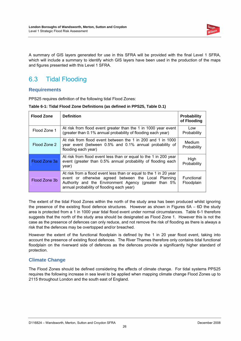
London Boroughs of Wandsworth, Merton, Sutton and Croydon Level 1 Strategic Flood Risk Assessment
D116824 – Wandsworth, Merton, Sutton and Croydon SFRA December 2008 26
A summary of GIS layers generated for use in this SFRA will be provided with the final Level 1 SFRA, which will include a summary to identify which GIS layers have been used in the production of the maps and figures presented with this Level 1 SFRA.
6.3 Tidal Flooding Requirements
PPS25 requires definition of the following tidal Flood Zones:
Table 6-1: Tidal Flood Zone Definitions (as defined in PPS25, Table D.1)
Flood Zone Definition Probability of Flooding
Flood Zone 1 At risk from flood event greater than the 1 in 1000 year event (greater than 0.1% annual probability of flooding each year)
Low Probability
Flood Zone 2 At risk from flood event between the 1 in 200 and 1 in 1000 year event (between 0.5% and 0.1% annual probability of flooding each year)
Medium Probability
Flood Zone 3a At risk from flood event less than or equal to the 1 in 200 year event (greater than 0.5% annual probability of flooding each year)
High Probability
Flood Zone 3b
At risk from a flood event less than or equal to the 1 in 20 year event or otherwise agreed between the Local Planning Authority and the Environment Agency (greater than 5% annual probability of flooding each year)
Functional Floodplain
The extent of the tidal Flood Zones within the north of the study area has been produced whilst ignoring the presence of the existing flood defence structures. However as shown in Figures 6A – 6D the study area is protected from a 1 in 1000 year tidal flood event under normal circumstances. Table 6-1 therefore suggests that the north of the study area should be designated as Flood Zone 1. However this is not the case as the presence of defences can only reduce, and not remove the risk of flooding as there is always a risk that the defences may be overtopped and/or breached.
However the extent of the functional floodplain is defined by the 1 in 20 year flood event, taking into account the presence of existing flood defences. The River Thames therefore only contains tidal functional floodplain on the riverward side of defences as the defences provide a significantly higher standard of protection.
Climate Change
The Flood Zones should be defined considering the effects of climate change. For tidal systems PPS25 requires the following increase in sea level to be applied when mapping climate change Flood Zones up to 2115 throughout London and the south east of England.
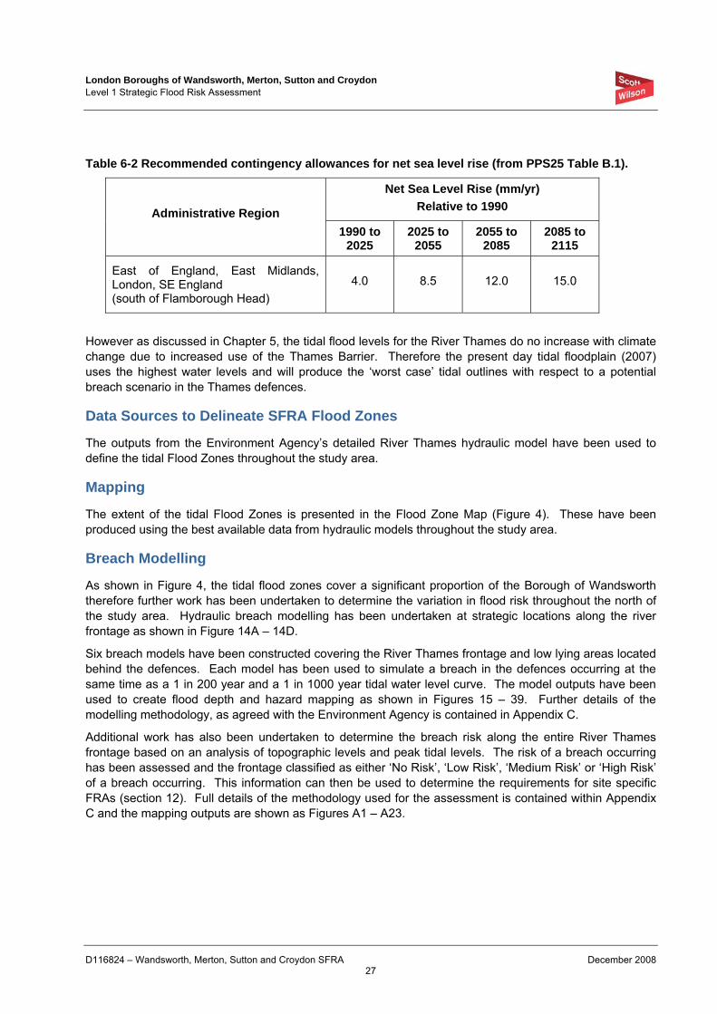
London Boroughs of Wandsworth, Merton, Sutton and Croydon Level 1 Strategic Flood Risk Assessment
D116824 – Wandsworth, Merton, Sutton and Croydon SFRA December 2008 27
Table 6-2 Recommended contingency allowances for net sea level rise (from PPS25 Table B.1).
Net Sea Level Rise (mm/yr) Relative to 1990 Administrative Region
1990 to 2025
2025 to 2055
2055 to 2085
2085 to 2115
East of England, East Midlands, London, SE England (south of Flamborough Head)
4.0 8.5 12.0 15.0
However as discussed in Chapter 5, the tidal flood levels for the River Thames do no increase with climate change due to increased use of the Thames Barrier. Therefore the present day tidal floodplain (2007) uses the highest water levels and will produce the ‘worst case’ tidal outlines with respect to a potential breach scenario in the Thames defences.
Data Sources to Delineate SFRA Flood Zones
The outputs from the Environment Agency’s detailed River Thames hydraulic model have been used to define the tidal Flood Zones throughout the study area.
Mapping
The extent of the tidal Flood Zones is presented in the Flood Zone Map (Figure 4). These have been produced using the best available data from hydraulic models throughout the study area.
Breach Modelling
As shown in Figure 4, the tidal flood zones cover a significant proportion of the Borough of Wandsworth therefore further work has been undertaken to determine the variation in flood risk throughout the north of the study area. Hydraulic breach modelling has been undertaken at strategic locations along the river frontage as shown in Figure 14A – 14D.
Six breach models have been constructed covering the River Thames frontage and low lying areas located behind the defences. Each model has been used to simulate a breach in the defences occurring at the same time as a 1 in 200 year and a 1 in 1000 year tidal water level curve. The model outputs have been used to create flood depth and hazard mapping as shown in Figures 15 – 39. Further details of the modelling methodology, as agreed with the Environment Agency is contained in Appendix C.
Additional work has also been undertaken to determine the breach risk along the entire River Thames frontage based on an analysis of topographic levels and peak tidal levels. The risk of a breach occurring has been assessed and the frontage classified as either ‘No Risk’, ‘Low Risk’, ‘Medium Risk’ or ‘High Risk’ of a breach occurring. This information can then be used to determine the requirements for site specific FRAs (section 12). Full details of the methodology used for the assessment is contained within Appendix C and the mapping outputs are shown as Figures A1 – A23.
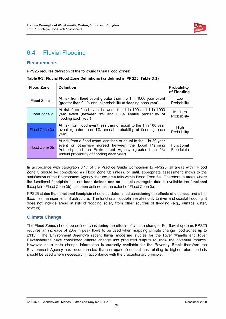
London Boroughs of Wandsworth, Merton, Sutton and Croydon Level 1 Strategic Flood Risk Assessment
D116824 – Wandsworth, Merton, Sutton and Croydon SFRA December 2008 28
6.4 Fluvial Flooding Requirements
PPS25 requires definition of the following fluvial Flood Zones:
Table 6-3: Fluvial Flood Zone Definitions (as defined in PPS25, Table D.1)
Flood Zone Definition Probability of Flooding
Flood Zone 1 At risk from flood event greater than the 1 in 1000 year event (greater than 0.1% annual probability of flooding each year)
Low Probability
Flood Zone 2 At risk from flood event between the 1 in 100 and 1 in 1000 year event (between 1% and 0.1% annual probability of flooding each year)
Medium Probability
Flood Zone 3a At risk from flood event less than or equal to the 1 in 100 year event (greater than 1% annual probability of flooding each year)
High Probability
Flood Zone 3b
At risk from a flood event less than or equal to the 1 in 20 year event or otherwise agreed between the Local Planning Authority and the Environment Agency (greater than 5% annual probability of flooding each year)
Functional Floodplain
In accordance with paragraph 3.17 of the Practice Guide Companion to PPS25, all areas within Flood Zone 3 should be considered as Flood Zone 3b unless, or until, appropriate assessment shows to the satisfaction of the Environment Agency that the area falls within Flood Zone 3a. Therefore in areas where the functional floodplain has not been defined and no suitable surrogate data is available the functional floodplain (Flood Zone 3b) has been defined as the extent of Flood Zone 3a.
PPS25 states that functional floodplain should be determined considering the effects of defences and other flood risk management infrastructure. The functional floodplain relates only to river and coastal flooding, it does not include areas at risk of flooding solely from other sources of flooding (e.g., surface water, sewers).
Climate Change
The Flood Zones should be defined considering the effects of climate change. For fluvial systems PPS25 requires an increase of 20% in peak flows to be used when mapping climate change flood zones up to 2115. The Environment Agency’s recent fluvial modelling studies for the River Wandle and River Ravensbourne have considered climate change and produced outputs to show the potential impacts. However no climate change information is currently available for the Beverley Brook therefore the Environment Agency has recommended that surrogate flood outlines relating to higher return periods should be used where necessary, in accordance with the precautionary principle.
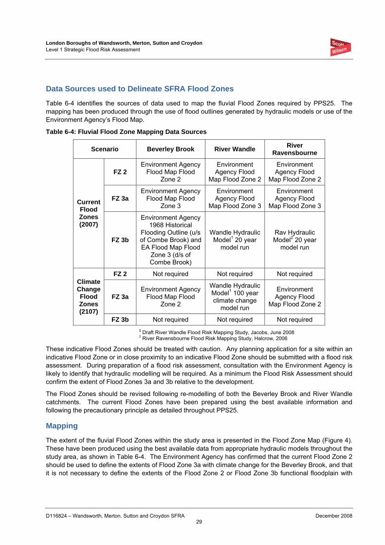
London Boroughs of Wandsworth, Merton, Sutton and Croydon Level 1 Strategic Flood Risk Assessment
D116824 – Wandsworth, Merton, Sutton and Croydon SFRA December 2008 29
Data Sources used to Delineate SFRA Flood Zones
Table 6-4 identifies the sources of data used to map the fluvial Flood Zones required by PPS25. The mapping has been produced through the use of flood outlines generated by hydraulic models or use of the Environment Agency’s Flood Map.
Table 6-4: Fluvial Flood Zone Mapping Data Sources
Scenario Beverley Brook River Wandle River Ravensbourne
FZ 2 Environment Agency
Flood Map Flood Zone 2
Environment Agency Flood
Map Flood Zone 2
Environment Agency Flood
Map Flood Zone 2
FZ 3a Environment Agency
Flood Map Flood Zone 3
Environment Agency Flood
Map Flood Zone 3
Environment Agency Flood
Map Flood Zone 3 Current Flood Zones (2007)
FZ 3b
Environment Agency 1968 Historical
Flooding Outline (u/s of Combe Brook) and EA Flood Map Flood
Zone 3 (d/s of Combe Brook)
Wandle Hydraulic Model1 20 year
model run
Rav Hydraulic Model2 20 year
model run
FZ 2 Not required Not required Not required
FZ 3a Environment Agency
Flood Map Flood Zone 2
Wandle Hydraulic Model1 100 year climate change
model run
Environment Agency Flood
Map Flood Zone 2
Climate Change Flood Zones (2107)
FZ 3b Not required Not required Not required 1 Draft River Wandle Flood Risk Mapping Study, Jacobs, June 2008 2 River Ravensbourne Flood Risk Mapping Study, Halcrow, 2006
These indicative Flood Zones should be treated with caution. Any planning application for a site within an indicative Flood Zone or in close proximity to an indicative Flood Zone should be submitted with a flood risk assessment. During preparation of a flood risk assessment, consultation with the Environment Agency is likely to identify that hydraulic modelling will be required. As a minimum the Flood Risk Assessment should confirm the extent of Flood Zones 3a and 3b relative to the development.
The Flood Zones should be revised following re-modelling of both the Beverley Brook and River Wandle catchments. The current Flood Zones have been prepared using the best available information and following the precautionary principle as detailed throughout PPS25.
Mapping
The extent of the fluvial Flood Zones within the study area is presented in the Flood Zone Map (Figure 4). These have been produced using the best available data from appropriate hydraulic models throughout the study area, as shown in Table 6-4. The Environment Agency has confirmed that the current Flood Zone 2 should be used to define the extents of Flood Zone 3a with climate change for the Beverley Brook, and that it is not necessary to define the extents of the Flood Zone 2 or Flood Zone 3b functional floodplain with
London Boroughs of Wandsworth, Merton, Sutton and Croydon Level 1 Strategic Flood Risk Assessment
D116824 – Wandsworth, Merton, Sutton and Croydon SFRA December 2008 30
climate change. It is recommended that following completion of the Beverley Brook re-modelling work this document should be updated to include revised Flood Zones for present day and the climate change scenario.
6.5 Sewer Flooding Requirements
Areas at risk from sewer flooding have been determined through review of the records from the DG5 registers provided by Thames Water.
As per fluvial flooding, areas with high, medium and low probability should be defined based on the available data. The definition of functional floodplain is not required for flooding from sewers.
Due to the lack of resolution of the data and the relatively short period for which the records are available (≤10 years), definition of flooding probability cannot currently follow the same approach as that used for fluvial or tidal flooding. Therefore based on the available data the following criteria have been used:
• High Probability - > 5 properties affected within the previous 10 year period
• Medium Probability – between 3 and 5 properties affected within the previous 10 year period
• Low Probability - < 3 properties affected within the previous 10 year period
Climate Change
Climate change is estimated to result in milder wetter winters and increased summer rainfall intensity. This combination will increase the pressure on existing sewer systems effectively reducing their design standard, leading to more frequent flooding. PPS25 Table D2 recommends that a 20% increase in rainfall intensity is considered up to 2085, and a 30% increase up to 2115, as shown in Table 6-5.
The current data does not enable a robust assessment of the effects of climate change on sewer flooding to be undertaken. Therefore in the absence of accurate data the effects of climate change should be taken to result in an increase in the flooding probability of each post code area by one category. For example where a post code area is currently identified to have a low probability, accounting for the effects of climate change the area has been defined as medium probability.
Data Source used for SFRA Mapping
Mapping of sewer flooding probability areas has been undertaken using records from Thames Water’s DG5 registers and a review of historical flooding records.
Mapping
Figures 7A – 7D illustrate the areas suspected to be suffering from high, medium and low probability of flooding throughout the study area. This is based on the post code prefixes for which sewer flooding data has been supplied.
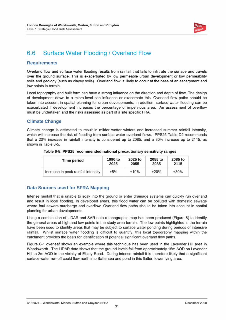
London Boroughs of Wandsworth, Merton, Sutton and Croydon Level 1 Strategic Flood Risk Assessment
D116824 – Wandsworth, Merton, Sutton and Croydon SFRA December 2008 31
6.6 Surface Water Flooding / Overland Flow Requirements
Overland flow and surface water flooding results from rainfall that fails to infiltrate the surface and travels over the ground surface. This is exacerbated by low permeable urban development or low permeability soils and geology (such as clayey soils). Overland flow is likely to occur at the base of an escarpment and low points in terrain.
Local topography and built form can have a strong influence on the direction and depth of flow. The design of development down to a micro-level can influence or exacerbate this. Overland flow paths should be taken into account in spatial planning for urban developments. In addition, surface water flooding can be exacerbated if development increases the percentage of impervious area. An assessment of overflow must be undertaken and the risks assessed as part of a site specific FRA.
Climate Change
Climate change is estimated to result in milder wetter winters and increased summer rainfall intensity, which will increase the risk of flooding from surface water overland flows. PPS25 Table D2 recommends that a 20% increase in rainfall intensity is considered up to 2085, and a 30% increase up to 2115, as shown in Table 6-5.
Table 6-5: PPS25 recommended national precautionary sensitivity ranges
Time period 1990 to 2025
2025 to 2055
2055 to 2085
2085 to 2115
Increase in peak rainfall intensity +5% +10% +20% +30%
Data Sources used for SFRA Mapping
Intense rainfall that is unable to soak into the ground or enter drainage systems can quickly run overland and result in local flooding. In developed areas, this flood water can be polluted with domestic sewage where foul sewers surcharge and overflow. Overland flow paths should be taken into account in spatial planning for urban developments.
Using a combination of LiDAR and SAR data a topographic map has been produced (Figure 8) to identify the general areas of high and low points in the study area terrain. The low points highlighted in the terrain have been used to identify areas that may be subject to surface water ponding during periods of intensive rainfall. Whilst surface water flooding is difficult to quantify, this local topography mapping within the catchment provides the basis for identification of potential significant overland flow paths.
Figure 6-1 overleaf shows an example where this technique has been used in the Lavender Hill area in Wandsworth. The LiDAR data shows that the ground levels fall from approximately 15m AOD on Lavender Hill to 2m AOD in the vicinity of Elsley Road. During intense rainfall it is therefore likely that a significant surface water run-off could flow north into Battersea and pond in this flatter, lower lying area.
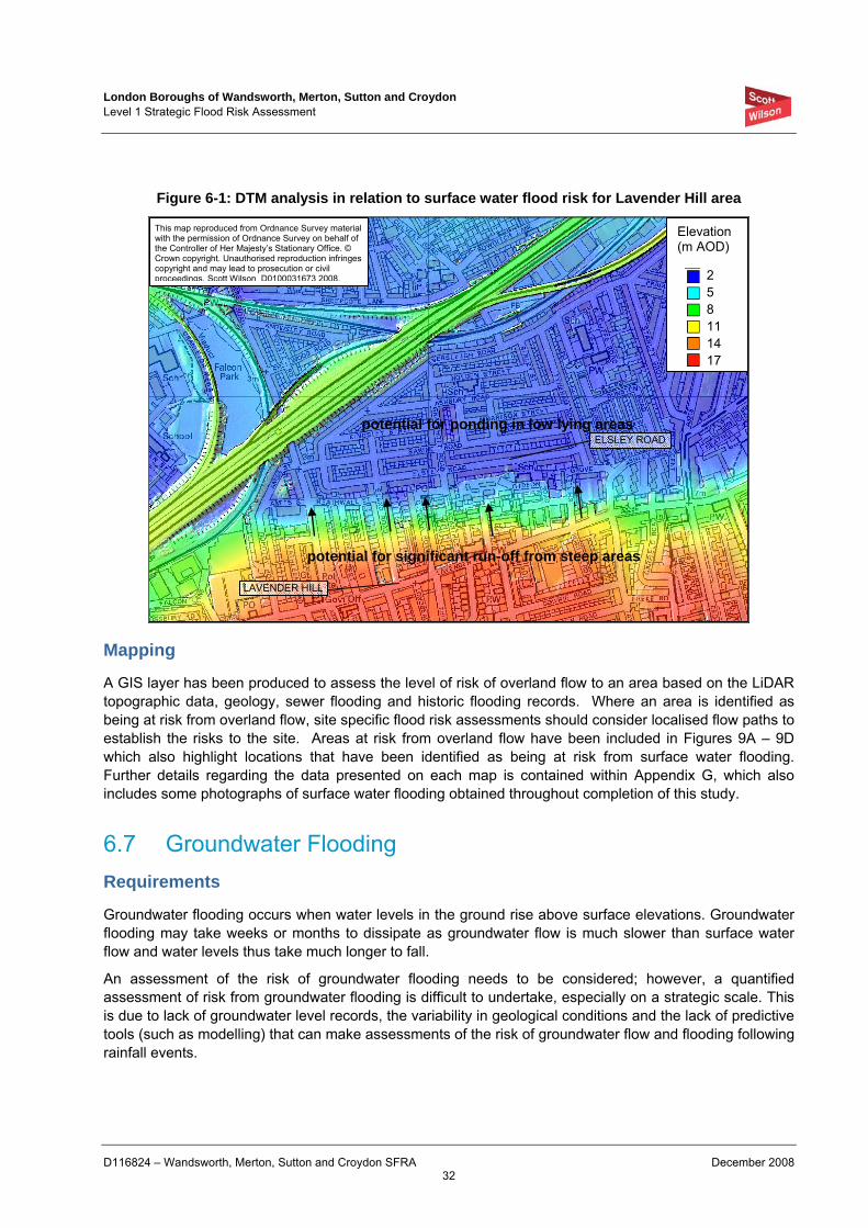
London Boroughs of Wandsworth, Merton, Sutton and Croydon Level 1 Strategic Flood Risk Assessment
D116824 – Wandsworth, Merton, Sutton and Croydon SFRA December 2008 32
Figure 6-1: DTM analysis in relation to surface water flood risk for Lavender Hill area
Mapping
A GIS layer has been produced to assess the level of risk of overland flow to an area based on the LiDAR topographic data, geology, sewer flooding and historic flooding records. Where an area is identified as being at risk from overland flow, site specific flood risk assessments should consider localised flow paths to establish the risks to the site. Areas at risk from overland flow have been included in Figures 9A – 9D which also highlight locations that have been identified as being at risk from surface water flooding. Further details regarding the data presented on each map is contained within Appendix G, which also includes some photographs of surface water flooding obtained throughout completion of this study.
6.7 Groundwater Flooding Requirements
Groundwater flooding occurs when water levels in the ground rise above surface elevations. Groundwater flooding may take weeks or months to dissipate as groundwater flow is much slower than surface water flow and water levels thus take much longer to fall.
An assessment of the risk of groundwater flooding needs to be considered; however, a quantified assessment of risk from groundwater flooding is difficult to undertake, especially on a strategic scale. This is due to lack of groundwater level records, the variability in geological conditions and the lack of predictive tools (such as modelling) that can make assessments of the risk of groundwater flow and flooding following rainfall events.
This map reproduced from Ordnance Survey material with the permission of Ordnance Survey on behalf of the Controller of Her Majesty’s Stationary Office. © Crown copyright. Unauthorised reproduction infringes copyright and may lead to prosecution or civil proceedings. Scott Wilson D0100031673 2008.
Elevation (m AOD)
2 5 8 11 14 17
potential for significant run-off from steep areas
potential for ponding in low lying areas
LAVENDER HILL
ELSLEY ROAD
London Boroughs of Wandsworth, Merton, Sutton and Croydon Level 1 Strategic Flood Risk Assessment
D116824 – Wandsworth, Merton, Sutton and Croydon SFRA December 2008 33
Data Sources used for SFRA Mapping
A small number of recorded groundwater flooding occurrences in the study area has been provided by the Environment Agency, these are generally not located on London Clay and Alluvium deposits as these impermeable soils act as an aquiclude and prevent groundwater rising to the surface.
The majority of the reported groundwater incidents are located within the River Terrace Deposits distributed throughout the study area. However groundwater flooding is most likely to occur where an interface between the Chalk and the River Terrace deposits allows groundwater to rise up through these permeable strata to the surface.
The identification of local geology within the catchment provides a strategic basis for flood risk estimation, which should be used in conjunction with the historic records to determine the groundwater flooding risk.
Mapping
The GIS layer provided by the Environment Agency showing records of groundwater flooding incidents between 2000 and 2005 is shown in Figure 10. Where an area is identified as being at risk from groundwater flooding, site specific flood risk assessments should consider localised groundwater levels and geology (Figures 3A and 3B) to establish the risks to the site.
6.8 Artificial Sources / Infrastructure Failure Requirements
No significant artificial flood sources have been identified throughout this study, however should additional sources be identified the potential consequences of failure will need to be assessed. A typical example of a necessary assessment would involve modelling to determine the impact of a reservoir/dam failure, which could potentially rapidly inundate businesses and properties with deep fast flowing water.
London Boroughs of Wandsworth, Merton, Sutton and Croydon Level 1 Strategic Flood Risk Assessment
D116824 – Wandsworth, Merton, Sutton and Croydon SFRA December 2008 34
7 Flood Mapping and Application
7.1 Introduction The following section is intended for use in conjunction with the flood zone and hazard zone mapping presented in the Appendices of this report. The flood zone maps should be used to complete the Sequential Test, identifying the particular flood zones and flood risks to individual allocation sites. The hazard and depth maps provided for the tidal areas in this Level 1 report provide a greater level of detail on the variation of residual flood risk from tidal flooding.
7.2 Flood Zone Mapping The strategic flood zone mapping for the London Boroughs in this SFRA study area have been produced in accordance with PPS25 using hydraulic modelling outputs provided by the Environment Agency. The fluvial outlines include Flood Zone 3b outputs. The River Thames only contains tidal functional floodplain on the riverward side of defences as the defences provide a significantly higher standard of protection.
The flood zone maps should be used as part of the Sequential Test to determine the level of flood risk associated with potential development allocations. Guidance on applying the Sequential Test is detailed in the following chapter.
7.3 Breach Modelling The tidal floodplain areas in the London Borough of Wandsworth are associated with the River Thames and mostly classified as defended. Therefore the associated flood risk with these areas is that of a residual nature, i.e. the flood risk as a result of a failure or breach in the flood defences.
To provide the London Borough of Wandsworth with further detail on the variation of the tidal residual risk, hydraulic breach modelling was undertaken along the River Thames frontage. Six flood cells were identified with six locations specified for breach locations. The detailed methodology used for the breach modelling is included in Appendix C.
The six breach locations modelled are presented in Table 7-1 alongside the associated peak water levels.
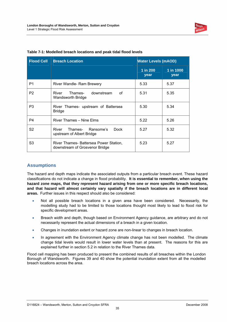
London Boroughs of Wandsworth, Merton, Sutton and Croydon Level 1 Strategic Flood Risk Assessment
D116824 – Wandsworth, Merton, Sutton and Croydon SFRA December 2008 35
Table 7-1: Modelled breach locations and peak tidal flood levels
Water Levels (mAOD) Flood Cell Breach Location
1 in 200 year
1 in 1000 year
P1 River Wandle- Ram Brewery 5.33 5.37
P2 River Thames- downstream of Wandsworth Bridge
5.31 5.35
P3 River Thames- upstream of Battersea Bridge
5.30 5.34
P4 River Thames – Nine Elms 5.22 5.26
S2 River Thames- Ransome’s Dock upstream of Albert Bridge
5.27 5.32
S3 River Thames- Battersea Power Station, downstream of Grosvenor Bridge
5.23 5.27
Assumptions
The hazard and depth maps indicate the associated outputs from a particular breach event. These hazard classifications do not indicate a change in flood probability. It is essential to remember, when using the hazard zone maps, that they represent hazard arising from one or more specific breach locations, and that hazard will almost certainly vary spatially if the breach locations are in different local areas. Further issues in this respect should also be considered:
• Not all possible breach locations in a given area have been considered. Necessarily, the modelling study had to be limited to those locations thought most likely to lead to flood risk for specific development areas.
• Breach width and depth, though based on Environment Agency guidance, are arbitrary and do not necessarily represent the actual dimensions of a breach in a given location.
• Changes in inundation extent or hazard zone are non-linear to changes in breach location.
• In agreement with the Environment Agency climate change has not been modelled. The climate change tidal levels would result in lower water levels than at present. The reasons for this are explained further in section 5.2 in relation to the River Thames data.
Flood cell mapping has been produced to present the combined results of all breaches within the London Borough of Wandsworth. Figures 39 and 40 show the potential inundation extent from all the modelled breach locations across the area.

London Boroughs of Wandsworth, Merton, Sutton and Croydon Level 1 Strategic Flood Risk Assessment
D116824 – Wandsworth, Merton, Sutton and Croydon SFRA December 2008 36
Limitations
To obtain a complete analysis of residual risk a breach location would be required every 50m along the River Thames frontage. Instead strategic locations have been identified by LB Wandsworth where potential allocations are likely to require further information as part of the Exception Test. In addition the Environment Agency has been consulted on the breach locations and alternative locations suggested in relation to defence condition, historical flooding and the existing communities potentially at risk.
Areas that are shown between the breaches as white areas are not necessarily free from flooding. The depth and hazard maps represent the results associated with a specific location. The composite mapping presents the greatest flood depth associated with all six breach locations.
In order to provide additional information on the variation of residual risk along the entire frontage, a topographic assessment has been carried out which is described in section 7.6. If a development site lies within an area not covered by one of the six specific breach locations specified then the riverside topography mapping should initially be reviewed to provide further information to assist with Sequential and Exception testing of additional sites in the future.
7.4 Depth Mapping These maps show the water depth in metres associated with a breach event at a specific location. The depth varies across the flood cell in relation to ground levels, where lower levels are more likely to experience deeper flooding in the event of a breach.
7.5 Hazard Mapping Hazard mapping presents the results of breach modelling within each flood cell in accordance with the FD2320/21 Defra/EA Flood Risks to People Report. However as the breach modelling has been completed on a strategic scale a debris factor cannot accurately be assigned, therefore for the purposes of this study the hazard mapping shows a relation of depth and velocity.
7.6 Riverside Topographic Assessment The riverside topographic assessment mapping provides additional information regarding the potential consequences of a breach occurring along LB Wandsworth’s River Thames frontage. The full methodology is described within Appendix C, however in summary the assessment has considered ground levels and peak flood levels to determine the potential inflow of water through a theoretical breach occurring anywhere along the frontage.
The data has been analysed to assign a ‘riverside category’ along the entire frontage to give an indication of the potential consequences of a breach occurring. This illustrates the areas which could potentially be significantly inundated if a breach was to occur. It should be noted that the categories do not in any way relate to the probability of a defence breach occurring, which has not been assessed in this study.
Cross sections have been through of the land behind the defences at 20m intervals along the frontage, which extend 400m inland. Ground levels have then been extracted at seven points for each section to show how ground levels vary with distance from the breach. The ground levels have been compared with peak flood levels to determine the consequences of a breach throughout the frontage, which has been
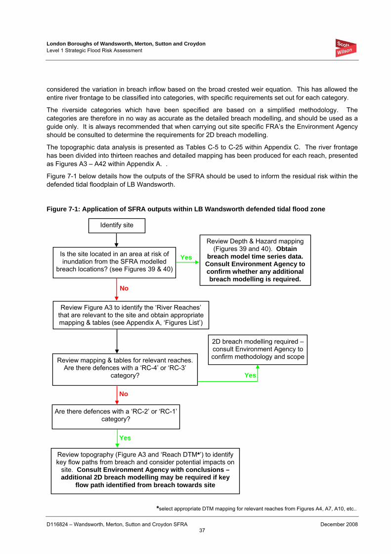
London Boroughs of Wandsworth, Merton, Sutton and Croydon Level 1 Strategic Flood Risk Assessment
D116824 – Wandsworth, Merton, Sutton and Croydon SFRA December 2008 37
considered the variation in breach inflow based on the broad crested weir equation. This has allowed the entire river frontage to be classified into categories, with specific requirements set out for each category.
The riverside categories which have been specified are based on a simplified methodology. The categories are therefore in no way as accurate as the detailed breach modelling, and should be used as a guide only. It is always recommended that when carrying out site specific FRA’s the Environment Agency should be consulted to determine the requirements for 2D breach modelling.
The topographic data analysis is presented as Tables C-5 to C-25 within Appendix C. The river frontage has been divided into thirteen reaches and detailed mapping has been produced for each reach, presented as Figures A3 – A42 within Appendix A. .
Figure 7-1 below details how the outputs of the SFRA should be used to inform the residual risk within the defended tidal floodplain of LB Wandsworth.
Figure 7-1: Application of SFRA outputs within LB Wandsworth defended tidal flood zone
Identify site
Is the site located in an area at risk of inundation from the SFRA modelled
breach locations? (see Figures 39 & 40)
Review Depth & Hazard mapping (Figures 39 and 40). Obtain
breach model time series data. Consult Environment Agency to confirm whether any additional breach modelling is required.
Review Figure A3 to identify the ‘River Reaches’ that are relevant to the site and obtain appropriate mapping & tables (see Appendix A, ‘Figures List’)
Review mapping & tables for relevant reaches. Are there defences with a ‘RC-4’ or ‘RC-3’
category?
2D breach modelling required – consult Environment Agency to confirm methodology and scope
Are there defences with a ‘RC-2’ or ‘RC-1’ category?
Review topography (Figure A3 and ‘Reach DTM*’) to identify key flow paths from breach and consider potential impacts on
site. Consult Environment Agency with conclusions –additional 2D breach modelling may be required if key
flow path identified from breach towards site
Yes
No
Yes
No
Yes
*select appropriate DTM mapping for relevant reaches from Figures A4, A7, A10, etc..
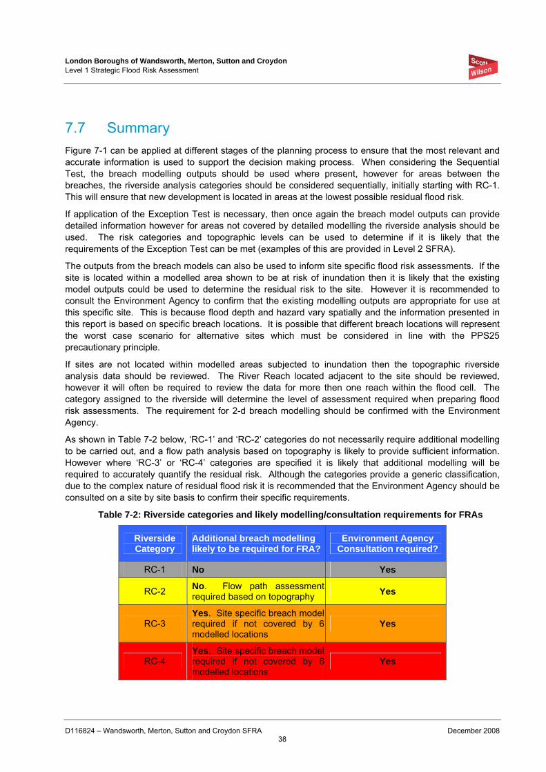
London Boroughs of Wandsworth, Merton, Sutton and Croydon Level 1 Strategic Flood Risk Assessment
D116824 – Wandsworth, Merton, Sutton and Croydon SFRA December 2008 38
7.7 Summary Figure 7-1 can be applied at different stages of the planning process to ensure that the most relevant and accurate information is used to support the decision making process. When considering the Sequential Test, the breach modelling outputs should be used where present, however for areas between the breaches, the riverside analysis categories should be considered sequentially, initially starting with RC-1. This will ensure that new development is located in areas at the lowest possible residual flood risk.
If application of the Exception Test is necessary, then once again the breach model outputs can provide detailed information however for areas not covered by detailed modelling the riverside analysis should be used. The risk categories and topographic levels can be used to determine if it is likely that the requirements of the Exception Test can be met (examples of this are provided in Level 2 SFRA).
The outputs from the breach models can also be used to inform site specific flood risk assessments. If the site is located within a modelled area shown to be at risk of inundation then it is likely that the existing model outputs could be used to determine the residual risk to the site. However it is recommended to consult the Environment Agency to confirm that the existing modelling outputs are appropriate for use at this specific site. This is because flood depth and hazard vary spatially and the information presented in this report is based on specific breach locations. It is possible that different breach locations will represent the worst case scenario for alternative sites which must be considered in line with the PPS25 precautionary principle.
If sites are not located within modelled areas subjected to inundation then the topographic riverside analysis data should be reviewed. The River Reach located adjacent to the site should be reviewed, however it will often be required to review the data for more then one reach within the flood cell. The category assigned to the riverside will determine the level of assessment required when preparing flood risk assessments. The requirement for 2-d breach modelling should be confirmed with the Environment Agency.
As shown in Table 7-2 below, ‘RC-1’ and ‘RC-2’ categories do not necessarily require additional modelling to be carried out, and a flow path analysis based on topography is likely to provide sufficient information. However where ‘RC-3’ or ‘RC-4’ categories are specified it is likely that additional modelling will be required to accurately quantify the residual risk. Although the categories provide a generic classification, due to the complex nature of residual flood risk it is recommended that the Environment Agency should be consulted on a site by site basis to confirm their specific requirements.
Table 7-2: Riverside categories and likely modelling/consultation requirements for FRAs
Riverside Category
Additional breach modelling likely to be required for FRA?
Environment Agency Consultation required?
RC-1 No Yes
RC-2 No. Flow path assessment required based on topography Yes
RC-3 Yes. Site specific breach model required if not covered by 6 modelled locations
Yes
RC-4 Yes. Site specific breach model required if not covered by 6 modelled locations
Yes
London Boroughs of Wandsworth, Merton, Sutton and Croydon Level 1 Strategic Flood Risk Assessment
D116824 – Wandsworth, Merton, Sutton and Croydon SFRA December 2008 39
It is likely that additional ‘windfall’ sites may become available for redevelopment in between the Boroughs
Table 7-2 outlines the process which should be followed to use the specific breach model outputs and riverside topographic analysis, and determine when further work is required during site specific flood risk assessments.
Where areas have been identified as ‘RC-4’ or ‘RC-3’, future site specific flood risk assessments should carry out 2D breach modelling. In areas of ‘RC-2’ or ‘RC-1’ categories, site specific flood risk assessments should focus on topographic site levels and analyse potential flow paths to the site from the River Thames. It is always recommended to consult with the Environment Agency, firstly to confirm whether modelling is required, and secondly to agree the modelling scope and methodology.
Table 7-2 provides an outline regarding the level of assessment required for an FRA for each category, Figures A3 – A42 shows the categorisation along the River Thames frontage.
London Boroughs of Wandsworth, Merton, Sutton and Croydon Level 1 Strategic Flood Risk Assessment
D116824 – Wandsworth, Merton, Sutton and Croydon SFRA December 2008 40
8 Guidance on Applying PPS25 Sequential Test
8.1 What is the PPS25 Sequential Test? PPS25 states that a sequential risk based approach to determining the suitability of land for development in flood risk areas should be applied to all levels of the planning process.
The PPS25 Sequential Test requires consideration of strategic land allocations with regard to flood risk, with the overall aim of locating new development in areas with the lowest risk of flooding. PPS25 requires local planning authorities to review flood risk across their districts, steering all development towards areas of lowest risk, through completion of the Sequential Test. Development is only permissible in areas at risk of flooding in exceptional circumstances where it can be demonstrated that there are no reasonably available sites in areas of lower risk, and the benefits of that development outweigh the risks from flooding. Such development is required to include mitigation/management measures to minimise risk to life and property should flooding occur.
The preparation and review of Local Development Documents (LDDs) should be used to review existing and proposed development. The overall aim being to allocate land in lower flood risk zones suitable for existing vulnerable uses already in medium and high flood zones. This will reduce flood risk and realise opportunities arising through redevelopment to improve the sustainability of communities.
Where it can be demonstrated by the Boroughs that the Sequential Test is passed, it will also be necessary in some circumstances for the Boroughs to demonstrate that all three elements of the Exception Test are satisfied. However it should be reinforced that the Exception Test will only be applicable in exceptional circumstances.
A Level 1 SFRA is designed to be sufficiently detailed to allow the application of the Sequential Test on the basis of Table D.1. of PPS25 (reproduced as Tables 6-1 and 6-3) and Figure 3.1 of its Practice Guide Companion and to also identify where application of the Exception Test (discussed further in Section 8) is necessary.
PPS25 acknowledges that some areas will (also) be at risk of flooding from sources other than tidal and fluvial. Consequently all sources of flooding must be considered when looking to locate new development. The other sources of flooding requiring consideration when situating new development allocations include:
• Overland Flow;
• Groundwater;
• Sewers; and
• Artificial Sources.
These sources (as sources of flooding) are typically less well understood than tidal and fluvial sources. Consequently data often only exists as point source data or through interpretation of local conditions. In addition there is conflicting guidance on suitable return periods to associate with floods arising from these sources. For example modern surface water drainage systems are constructed to a 1 in 30 year standard. Any rainfall event in excess of the 30 year return period would be expected to result in some flooding through insufficient capacities. Consequently when assessing these sources through the Sequential Test, if a location is recorded as having experienced flooding from an alternative flood source this should be investigated further in a site specific flood risk assessment.
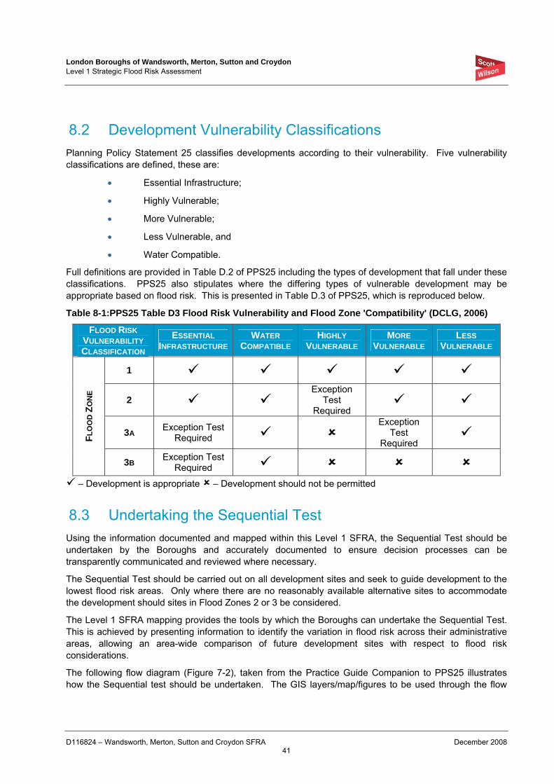
London Boroughs of Wandsworth, Merton, Sutton and Croydon Level 1 Strategic Flood Risk Assessment
D116824 – Wandsworth, Merton, Sutton and Croydon SFRA December 2008 41
8.2 Development Vulnerability Classifications Planning Policy Statement 25 classifies developments according to their vulnerability. Five vulnerability classifications are defined, these are:
• Essential Infrastructure;
• Highly Vulnerable;
• More Vulnerable;
• Less Vulnerable, and
• Water Compatible.
Full definitions are provided in Table D.2 of PPS25 including the types of development that fall under these classifications. PPS25 also stipulates where the differing types of vulnerable development may be appropriate based on flood risk. This is presented in Table D.3 of PPS25, which is reproduced below.
Table 8-1:PPS25 Table D3 Flood Risk Vulnerability and Flood Zone 'Compatibility' (DCLG, 2006)
FLOOD RISK VULNERABILITY CLASSIFICATION
ESSENTIAL INFRASTRUCTURE
WATER COMPATIBLE
HIGHLY VULNERABLE
MORE VULNERABLE
LESS VULNERABLE
1
2 Exception
Test Required
3A Exception Test Required
Exception Test
Required FL
OO
D Z
ON
E
3B Exception Test Required
– Development is appropriate – Development should not be permitted
8.3 Undertaking the Sequential Test Using the information documented and mapped within this Level 1 SFRA, the Sequential Test should be undertaken by the Boroughs and accurately documented to ensure decision processes can be transparently communicated and reviewed where necessary.
The Sequential Test should be carried out on all development sites and seek to guide development to the lowest flood risk areas. Only where there are no reasonably available alternative sites to accommodate the development should sites in Flood Zones 2 or 3 be considered.
The Level 1 SFRA mapping provides the tools by which the Boroughs can undertake the Sequential Test. This is achieved by presenting information to identify the variation in flood risk across their administrative areas, allowing an area-wide comparison of future development sites with respect to flood risk considerations.
The following flow diagram (Figure 7-2), taken from the Practice Guide Companion to PPS25 illustrates how the Sequential test should be undertaken. The GIS layers/map/figures to be used through the flow
London Boroughs of Wandsworth, Merton, Sutton and Croydon Level 1 Strategic Flood Risk Assessment
D116824 – Wandsworth, Merton, Sutton and Croydon SFRA December 2008 42
diagram are also highlighted. The full process is described fully in PPS25, A Practice Guide Companion, ‘Living Draft’ 2007.
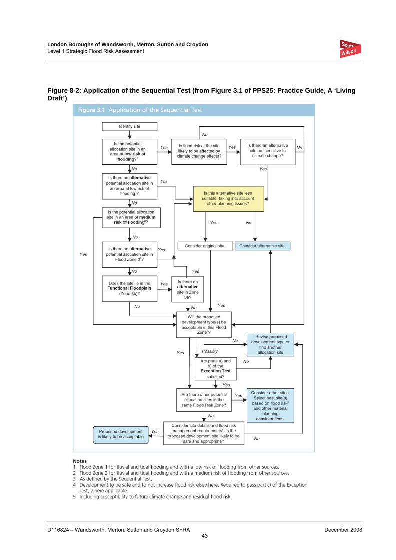
London Boroughs of Wandsworth, Merton, Sutton and Croydon Level 1 Strategic Flood Risk Assessment
D116824 – Wandsworth, Merton, Sutton and Croydon SFRA December 2008 43
Figure 8-2: Application of the Sequential Test (from Figure 3.1 of PPS25: Practice Guide, A ‘Living Draft’)
London Boroughs of Wandsworth, Merton, Sutton and Croydon Level 1 Strategic Flood Risk Assessment
D116824 – Wandsworth, Merton, Sutton and Croydon SFRA December 2008 44
Additional Guidance
The sequence of steps presented below in tandem with Figure 8-2 is designed to guide the Boroughs and developers through the Sequential Test. The steps are designed to ensure land allocations are allocated in line with the principles of the Sequential Test, and where necessary in exceptional circumstances, the principles of Exception Test are clearly identified.
Recommended stages for the Boroughs application of the Sequential Test:
1. The developments (i.e. housing, hospitals, industrial etc) that need to be accommodated by the Boroughs should be assigned a vulnerability classification in accordance with Table D.2 “Flood Risk Vulnerability Classification” in PPS25;
2. The Flood Zone classification of all development sites should be determined based on a review of the Environment Agency Flood Zones for fluvial sources. This should consider the effects of climate change on flood zone definition for the design life of any development that the site may be suitable for, i.e.:
• 60 years – up to 2070 for commercial / industrial developments; and
• 100 years – up to 2110 for residential developments
3. In the first instance the ‘highly vulnerable’ developments should be located in those sites identified as being within Flood Zone 1. If the ‘highly vulnerable developments’ cannot be located in Flood Zone 1, because the identified sites are unsuitable or there are insufficient sites in Flood Zone 1 then sites in Flood Zone 2 can be considered. According to PPS25 ‘highly vulnerable’ uses would not be permitted in Flood Zone 3.
4. Once all ‘highly vulnerable’ developments have been allocated to a development site, the Boroughs can consider those development types defined as ‘more vulnerable’. In the first instance ‘more vulnerable’ development should be located in any unallocated sites in Flood Zone 1. Where these sites are unsuitable or there are insufficient sites, sites in Flood Zone 2 can be considered. If there are insufficient sites in Flood Zone 1 or 2 to accommodate the ‘more vulnerable’ development types, sites in Flood Zone 3a can be considered. However, any ‘more vulnerable’ developments in Flood Zone 3a will require application of the Exception Test. Responses to parts ‘a’ and ‘b’ of the Exception Test should be prepared and agreed through consultation with the Environment Agency before ‘part c’ is tackled. ‘More vulnerable’ developments are not appropriate in Flood Zone 3b – functional floodplain.
5. Once all ‘more vulnerable’ developments have been allocated to a development site, the Boroughs can consider those development types defined as ‘less vulnerable’. In the first instance ‘less vulnerable’ development should be located in any remaining unallocated sites in Flood Zone 1, 2 or 3a. Less vulnerable development types are not appropriate in Flood Zone 3b – Functional Floodplain.
6. ‘Essential infrastructure’ developments should also be preferentially located in the lowest flood risk zones, however this type of development can be located in Flood Zones 3a and 3b, where necessary, through application of the Exception Test. Where these types of development are located in Flood Zone 3a or 3b responses to parts ‘a’ and ‘b’ of the Exception Test will be required before ‘part c’ is tackled.
London Boroughs of Wandsworth, Merton, Sutton and Croydon Level 1 Strategic Flood Risk Assessment
D116824 – Wandsworth, Merton, Sutton and Croydon SFRA December 2008 45
7. Water compatible development typically has the least flood risk constraints and it is therefore recommended to consider these types of development last when allocating development sites.
8. For decisions made through stages 4 to 7 it will also be necessary to consider the risks posed to the site from other flood sources and where comparable development sites in the same flood zone may be more suitable due to:
• flood risk management measures,
• the rate of flooding,
• flood water depth, or,
• flood water velocity.
Where the development type is highly vulnerable, more vulnerable, less vulnerable or essential infrastructure and a site is found to be impacted by a recurrent flood source (other than fluvial), the site and flood sources should be investigated further irrespective of a requirement for the Exception Test. This should be discussed with the Environment Agency to establish the appropriate time for the assessment to be undertaken, (i.e. Exception Test through a Level 2 SFRA or through a site specific flood risk assessment).
9. It is recommended that the Boroughs complete the Proforma in Table D1 (Appendix D) to assist in completion of the Sequential Test to provide a transparent framework and justification of sites that may need to be Exception Tested.
10. The potential growth areas identified by each Borough are presented in Figures D1-1 – D4-2 in Appendix D in relation to flood risk. This provides a starting point for the Boroughs to consider the Sequential Test.
Additional Sequential Test Guidance for LB Wandsworth Defended Tidal Floodplain
11. A significant proportion of LB Wandsworth is located within the defended tidal Flood Zone 3a and it is therefore likely that development will be required in these areas to meet growth targets. Should this be the case, the breach modelling outputs provided should be used to allow application of a sequential approach within the LB Wandsworth defended tidal flood zone.
12. The hazard mapping should initially be reviewed to locate sites within areas of low flood hazard where possible. If there are no suitable and reasonably available sites within low hazard zones, then medium hazard zones can then be considered. Again if no sites are available in medium hazard zones then high hazard zones can be considered.
13. If the sites being considered are not covered by the six modelled breach locations, then the riverside topographic analysis should be used to inform the sequential approach. Areas which are identified as ‘RC-1’ should initially be given priority, following which the ‘RC-2’, ‘RC-3’ and ‘RC-4’ areas should sequentially be considered.
London Boroughs of Wandsworth, Merton, Sutton and Croydon Level 1 Strategic Flood Risk Assessment
D116824 – Wandsworth, Merton, Sutton and Croydon SFRA December 2008 46
9 Guidance on Applying the PPS25 Exception Test
9.1 Why is there an Exception Test? Application of the Sequential Test aims to steer all development towards areas of lowest risk. However, PPS25 acknowledges that in some circumstances it may not be possible to locate development in areas of low or appropriate (considering development vulnerability, Table 7.1) flood risk. In these circumstances, it is necessary to clearly demonstrate that the benefits for development of a site outweigh the flood risks to the development and its occupants.
In addition, it may be necessary to apply the Exception Test where the Sequential Test alone cannot deliver acceptable sites, and where some continuing development is necessary for wider sustainable development reasons, taking into account the need to avoid social or economic blight and the need for essential civil infrastructure to remain operational during floods.
9.2 What is the Exception Test? The Exception Test is an additional test to be applied by decision-makers following application of the Sequential Test. The Exception Test is a series of three criteria as shown below, all of which must be satisfied for development in a flood risk area to be considered acceptable. For the Exception Test to be passed:
a) It must be demonstrated that the development provides wider sustainability benefits to the community that outweigh flood risk, informed by a SFRA;
b) The development should be on developable previously developed land or, if not, it must be demonstrated there is no such alternative land available; and
c) A FRA must demonstrate that the development will be safe, without increasing flood risk elsewhere, and, where possible, reducing flood risk overall.
All three parts of this test must be satisfied in order for the development to be considered acceptable in terms of flood risk. There must be robust evidence in support of every part of the test.
This report is intended as a Level 1 SFRA - should the Sequential Test identify the need for allocations to undergo the Exception Test this will be addressed in a Level 2 SFRA.
Where use of the Exception Test is required, decision-makers should apply it at the earliest stage possible in planning, to all LDD allocations for development and all planning applications other than for minor development.
A significant proportion of LB Wandsworth is located within Flood Zone 3a of the River Thames, therefore it is likely that the requirements of the Exception Test will need to be satisfied for ‘more vulnerable’ e.g. residential development in this area.
To inform LB Wandsworth of the variation of flood risk in their tidal floodplain, breach modelling has been undertaken for this Level 1 SFRA to enable LB Wandsworth to take into account the variation in flood depth and hazard within Flood Zone 3a when allocating development sites through the Sequential Test. An additional riverside topographic analysis has been carried out to determine the potential consequences
London Boroughs of Wandsworth, Merton, Sutton and Croydon Level 1 Strategic Flood Risk Assessment
D116824 – Wandsworth, Merton, Sutton and Croydon SFRA December 2008 47
of a breach along the entire Thames frontage, to provide information for areas not covered by detailed breach modelling.
The breach modelling provides detailed flood depth, velocity and time to inundation outputs which can be used to inform the Exception Test. The information provided by the riverside analysis is less detailed than the modelling outputs, however the risk categories and topographic data can still be used as a conservative approach when considering the requirements of the Exception Test for sites in these areas.
Further examples of how to undertake the Exception Test with both approaches are contained within the SFRA Level 2 report.
London Boroughs of Wandsworth, Merton, Sutton and Croydon Level 1 Strategic Flood Risk Assessment
D116824 – Wandsworth, Merton, Sutton and Croydon SFRA December 2008 48
10 Flood Risk Management
10.1 Flood Defences The National Flood and Coastal Defence Database (NFCDD) compiled by the Environment Agency holds information on natural and man-made defences. The standard of these flood defences is only available for man-made defences. Figures 6A – 6D display the location of NFCDD defences throughout the study area.
The Flood Zones produced by the Environment Agency refer to the probability of flooding from rivers, the sea and tidal sources and ignore the presence of existing defences, because these can be breached, overtopped and may not be in existence for the lifetime of the development.
This conservative approach over time will reduce reliance on flood defences, raises the awareness of flood risk in defended areas and helps to ensure that is it not discounted as part of development but is managed appropriately.
Flood defences are typically designed and constructed to protect people and property from a given magnitude of flood. This is referred to as the design standard and may vary depending on the age of the structure, the value attributed to the people and property it is designed to serve and the scale of works necessary to construct the defence. For new defences, these issues and others are balanced through a cost benefit analysis to determine if investment in defence schemes can be justified.
Current
The NFCDD identifies a significant number of flood defences throughout the study area, which are classified as either tidal or fluvial defences. The Thames Tidal Defences, incorporating the Thames Barrier were designed to protect London from a tidal flood with a magnitude of 1 in 1000 years in the year 2030. So far sea level rise has not exceeded predicted rates and the defences are therefore providing a greater level of protection than 1 in 1000 years.
The fluvial flood defences throughout the study area typically consist of raised walls and embankments, which provide varying standards of protection ranging from 5 to 100 years. Many of the fluvial defences have a design standard less than 100 years, therefore a flood event of this magnitude would be expected to result in flooding despite the presence of a flood defence.
With this in mind the efficient operation of channels and culverts is paramount if the existing standard of flood defence is to be maintained for the study area. This requires maintenance by the defence owners which include the Environment Agency, Local Authorities and riparian owners or by the responsible drainage authority where appropriate remedial action does not take place.
Future
The Environment Agency is currently undertaking a comprehensive programme of study referred to as Thames Estuary 2100 (TE2100), to establish the best approaches to manage flood risk with respect to different climate change scenarios. A number of measures have been identified that could be implemented depending on the increase in sea level rise and storm surge that may be experienced over the next 100 years. TE2100 will recommend local policies that set the strategic direction of flood risk management, and high level, estuary-wide options to ensure these local policies are achieved.
London Boroughs of Wandsworth, Merton, Sutton and Croydon Level 1 Strategic Flood Risk Assessment
D116824 – Wandsworth, Merton, Sutton and Croydon SFRA December 2008 49
TE2100 will be recommending options that place more emphasis on floodplain management, in addition to flood defence. These options will include more appropriate use of the floodplain, making space for water, better flood awareness and flood-preparedness and improved emergency planning and response measures.
The TE2100 are currently consulting on ‘high level options’ and will submit the final plan central government in March 2010. It is recommended that progress of the TE2100 project should be closely monitored and this study should be updated to reflect the latest findings.
The Thames CFMP also includes policies that have been developed with the aim of promoting sustainable flood management solutions into the future, which are summarised in section 4.6.
10.2 Flood Warning The Environment Agency operates a flood warning service in areas at risk of flooding. The service is provided free of charge however homes and businesses must register with the service to receive warnings.
Flood Warning service consists of 4 codes, Flood Watch, Flood Warning, Severe Flood Warning and All Clear. A Flood Watch is issued when rivers are expected to overtop banks and cause low lying flooding. Our advice to the public is to keep an eye on the situation. A Flood Warning is issued when we expect property flooding. Our advice to the public is to act on this warning by taking steps to protect against and prevent flooding. A Severe is issued when the situation becomes much worse, numerous houses could be flooded and major infrastructure affected. This is also the trigger for the LA’s and emergency services to activate major incident plans.
It should be noted somewhere that on the fluvial rivers there is limited lead time from the onset of rain to the response of the river, meaning difficultly in providing a 2 hour lead time on flood warnings.
The flood warnings are disseminated through a variety of mediums that include TV, radio, Automated Voice Messaging service direct to recipients’ phone/fax/pager, internet and/or loudhailer. There is also an emergency Floodline number (0845 988 1188) and a quickdial number for specific areas.
Figure 11 illustrates the flood warning areas within the study area, with are categorised by flood source i.e. tidal and fluvial. The flood warning system helps residents in areas of flood risk prepare for floods, through preparation of obtaining sand bags, moving valuables upstairs and where necessary evacuating the property to minimise the potential consequences of flooding. It is not possible to provide any warning of flooding due to flood defence breach or failure, which could potentially cause rapid inundation of areas with deep fast flowing water. This is why residual risk planning and appropriate mitigation measures are required for development within the defended floodplain.
The Environment Agency would like to see an increase in flood-preparedness, so that people have already taken steps to reduce the consequences of a flood before the event. We would like to see an increase in the number of people that sign up to Flood Warnings Direct (via Floodline). This should be a target set in cooperation with the Emergency Planning Procedures.
Emergency Planning and Floodplain Management will be multi-agency tasks, requiring the coordination and clear allocation of roles and responsibilities. The Environment Agency sees itself as having a key role in each.
London Boroughs of Wandsworth, Merton, Sutton and Croydon Level 1 Strategic Flood Risk Assessment
D116824 – Wandsworth, Merton, Sutton and Croydon SFRA December 2008 50
10.3 Residual Risk Residual risk in a generic sense can be defined as ‘the remaining risk following the implementation of all risk avoidance, reduction and mitigation measures’ (Communities and Local Government, 2007). In a flood risk context, this residual risk pertains to the flood risk that remains after flood avoidance and alleviation measures have been put in place.
An example of residual risk relevant to the study area is breaching of the floodwalls located along the banks of the River Thames. It is possible that the defences could be breached due to collision of river traffic, terrorist action and/or hydrostatic water pressure during high tides. The defences could also be overtopped if the Thames Barrier failed to close and a storm surge travelled up the estuary into Central London.
As sea levels rise over time, the Barrier will have to close with increasing frequency, and not just in response to surge tides. With operational constraints limiting the number of closures in any one year, the risk of overtopping will increase.
Residual risk management therefore aims to prevent or mitigate the consequences of flooding that can occur despite the presence of flood alleviation measures.
Application of the Sequential Test as part of PPS25 aims to preferentially develop or relocate potential development sites into areas with low flood risk. Where this is not realistically possible, some development sites may be located in higher flood risk areas, such as PPS25 defined Flood Zones 2 and 3. As a result, such developments will require residual risk management to minimise the consequences of potential flooding, e.g. following a breach or overtopping of local defences.
Ensuring properties are defended to an appropriate design standard reduces flood risk. However, further options are also available should the residual risk to a development prove unacceptable. Details of potential residual risk management options are contained below:
Potential Evacuation and Rescue Routes
In the event of a flood incident, it is essential that the evacuation and rescue routes to and from any proposed development remain safe. The FD2320/21 Defra/EA Flood Risks to People Report provides requirements for maximum flood depth and velocity to quantify whether an evacuation route should be deemed safe. The Environment Agency requires safe access for new development for a 1 in 100/200 year design event as a minimum. The flood risk posed during an extreme 1 in 1000 year event should also be considered to allow the Boroughs to consult with the emergency services over the suitability of the access route. If potential evacuation routes are likely to become inundated so that safe access/egress would not be possible, then the proposed development should be relocated. This may also be the case should the possible evacuation routes be across particularly long or difficult terrain.
A key consideration in relation to the presence and use of evacuation routes is the vulnerability and mobility of those in danger of being inundated. Development for highly vulnerable users e.g. disabled or the elderly should be located away from high-risk areas. For this reason it is preferable that evacuation routes remain dry. The Sequential Test does not however differentiate between the vulnerability of the end users of the site, only the vulnerability of the intended use of the site. A proposed residential development for highly vulnerable end users (elderly, physically impaired etc) will still fall under the ‘More Vulnerable’ classification in Table D.2 of PPS25 and the Sequential and Exception Tests will apply accordingly. Where development for highly vulnerable end users cannot be avoided, safe and easy evacuation routes are essential.
London Boroughs of Wandsworth, Merton, Sutton and Croydon Level 1 Strategic Flood Risk Assessment
D116824 – Wandsworth, Merton, Sutton and Croydon SFRA December 2008 51
Time to Peak of Flood Hazard
The time to peak relates to the amount of time it takes for a flood event to reach its maximum level, flow or height. The greater the time to peak, the greater the time available for evacuation. The time to peak for residual flooding can be very short. Should a defence structure breach/fail then inundation can be rapid, resulting in a short time to peak for the areas local to the breach. On the other hand, during tidal events, should a breach occur early in the tidal cycle, the time to peak could be a lot slower. Typically, areas immediately adjacent to a breach location will have a shorter time to peak than areas setback from the flood defence.
The breach modelling outputs provide detailed information regarding the potential time of peak in the event of defence failure, albeit only for the specific scenarios that have been modelled. These have been provided to LB Wandsworth as digital animation files, which can be analysed when assessing proposed land allocations. Sites which are rapidly inundated with flood waters present a higher risk and could require additional mitigation and/or emergency planning measures. It is therefore recommended that LB Wandsworth should give preference to development sites with a greater time to peak of flood hazard where possible.
Methods of Managing Residual Flood Risk
The following sub-sections outline various methods available for the management of residual flood risk. The methods outlined will not be appropriate for all development types or all geographical areas. Therefore, they should be considered on a site-by-site basis. In addition, it is important that the use of such techniques do not exacerbate flooding elsewhere within the flood cell oversight.
Recreation, Amenity and Ecology
There are many different ways recreation, amenity and ecological improvements can be used to mitigate the residual risk of flooding either by substituting less vulnerable land uses or by attenuating flows or both. They range from the development of parks and open spaces through to river restoration schemes. In addition, they have wider ecological, biodiversity and sustainability benefits.
The basic function of these techniques is increased flood storage and the storage or conveyance of rainwater. Typical measures include various guises of pools, ponds, and ditches which all have the added benefit of improving the ecological and amenity value of an area. These features can provide a haven for local wildlife and the benefits of provision of open spaces has been proven in studies of storage areas created at Sutcliffe Park and Chinbrook Meadows in south east London.. They also provide recreation and encourage activities such as walking, cycling or wildlife watching.
Secondary Defences
Secondary defences are those that exist on the dry side of primary defences. Typically, their main function is to reduce the risk of residual flooding following a failure or overtopping of the primary defences.
Secondary defences can relocate floodwaters away from certain areas or reduce the rate of flood inundation following a residual event. However it is essential to ensure that diversion of flood waters does not increase flood risk to other people and properties in other areas.
Examples of secondary defences include embankments or raised areas behind flood defence walls, raised infrastructure e.g. railways or roads and, on a strategic level, canals, river and drainage networks. The
London Boroughs of Wandsworth, Merton, Sutton and Croydon Level 1 Strategic Flood Risk Assessment
D116824 – Wandsworth, Merton, Sutton and Croydon SFRA December 2008 52
latter are a form of secondary defence as they are able to convey or re-direct water away from flood prone areas even if this is not their primary function.
The railway embankments located in LB Wandsworth act as secondary defences in breach scenarios, although the roads passing underneath them create easily accessible flow paths. The embankments have been represented within the breach models (including the flow paths underneath) hence the modelling provides and accurate estimate of the extent of the inundated area.
Land Raising
Land raising can have mixed results when used as a secondary flood alleviation measure. It can be an effective method of reducing flood inundation on certain areas or developments by raising the finished levels above the predicted flood level. However, it will result in the reduction in flood storage volume on the floodplain and can exacerbate flooding elsewhere. Level for level compensatory storage must therefore be provided to ensure there is no loss of floodplain storage in undefended fluvial areas. Where possible an increase in flood storage volume should be provided to reduce the risk of flooding in the surrounding area.
Compensatory storage is not required in tidal defended areas however the potential impacts of reduced flood storage, potentially causing displacement of water should be considered to quantify any potential impacts throughout the flood cell. In order for any potential impacts to be realised a breach in the defences would be required therefore this should be assessed in terms of residual risk and a potential 2-d breach assessment may be necessary as part of the FRA to demonstrate the impacts of the land raising on the wider flood cell area.
Finished Floor Levels
Where developing in flood risk areas is unavoidable, the most common method of mitigating flood risk to people is to ensure habitable floor levels are raised above the maximum flood water level. The Environment Agency suggest a 300mm freeboard on the 1 in 100 year fluvial flood levels and 1 in 200 year tidal flood levels when setting finished floor levels in undefended areas (600mm freeboard is required for less precisely computed levels). For defended tidal situations, flood levels derived on the site from a 1 in 200 year modelled breach scenario should be used to set floor levels. No additional freeboard is required in tidal defended areas.
It is also necessary to ensure that proposed roads levels are such that emergency access and evacuation routes are maintained where possible at the 1 in 1000 year flood level. This can significantly reduce the risk of the proposed development becoming inundated by flooding. As with the land raising option, it is imperative that any assessment takes into consideration the volume of floodwater potentially displaced by such raising.
Flood Resistance
Flood resistance measures aim to prevent floodwaters from entering a property and damaging its fabric. Following the UK floods in 2000, the use of demountable flood barriers and door flood guards for individual properties has become more common. If installed correctly, in advance of a flood event these measures can work effectively. However complications can arise regarding transportation of defences and installation time, therefore a reasonable time period between flood warning and the onset of flooding is required.
The use of temporary resistance measures is considered appropriate for existing properties, however they are not recommended for new development. This is because the temporary measures require human
London Boroughs of Wandsworth, Merton, Sutton and Croydon Level 1 Strategic Flood Risk Assessment
D116824 – Wandsworth, Merton, Sutton and Croydon SFRA December 2008 53
intervention to function plus continued maintenance procedures which cannot be guaranteed. Permanent flood resistance measures such as use of low permeability materials to prevent water ingress are therefore recommended for new development.
Flood Resilience
Flood risk can be reduced by reducing either the probability or consequences of flooding, and preferably both. Increasing resilience to flood damage reduces the consequences and ensures that buildings can be swiftly returned to normal use following a flood event.
PPS25 recommends that a sequential approach should be applied to new developments to direct more vulnerable uses to parts of the site at less probability risk of flooding. Flood resilient construction may be considered if there is a low probability of shallow water depth inundating the development. The DCLG has recently released the report ‘Improving the Flood Performance of New Buildings’ which provides guidance on appropriate measures.
These measures are also applicable to existing properties and can reduce residual flood risk whilst also improving the insurability of homes in flood risk areas. The guidance identifies the key flood resistant measures as being:
• Replace timber floors with concrete and cover with tiles,
• Replace chipboard/MDF kitchen and bathroom units with plastic equivalents,
• Replace gypsum plaster with more water-resistant material, such as lime plaster or cement render,
• Move service meters, boilers, and electrical points well above likely flood levels, and,
• Put one-way valves into drainage pipes to prevent sewage backing up into the house.
Advice on flood mitigation for homes and businesses is also given in the ODPM’s 2003 report, ‘Preparing for Floods’ (ODPM, 2003b).
10.4 Emergency Planning The Boroughs hold overall responsibility for emergency planning, however the Environment Agency recommends that a flood forum group is involved throughout emergency planning and management. The specific details of the emergency plans throughout the study area have not been made available during this study as they are highly confidential documents for security reasons. However, it is understood that the Boroughs have emergency plans in place to respond to any incident that occurs within their administrative area.
There are three phases where emergency planning measures are required to be active as follows:
• Before a flood – raising flood awareness, ensuring no inappropriate use of the floodplain by vulnerable uses, ensuring that emergency access and egress routes are available, protecting vital infrastructure, ensuring adequate flood resilience measures are employed.
• During a flood – flood warning, rescuing occupants, providing temporary shelter/accommodation.
• After the flood – providing support to help people recover and return to their homes and businesses including liaison with insurance companies.
PPS25 classifies police stations, ambulance stations, fire stations and command centres as Highly Vulnerable buildings. Hospitals and care homes are classified as More Vulnerable establishments. In the
London Boroughs of Wandsworth, Merton, Sutton and Croydon Level 1 Strategic Flood Risk Assessment
D116824 – Wandsworth, Merton, Sutton and Croydon SFRA December 2008 54
event of an emergency, to ensure that those services vital to the rescue operation are not impacted by flood water, it is essential that all establishments related to these services are located in the lowest flood risk zones. In addition future development control polices should seek to locate more vulnerable institutes such as schools and care homes in areas of the lowest risk to minimise the potential for flood casualties.
Allied to this, nominated rest and reception centres should also be identified within the study area and compared with the outputs of this SFRA to ensure that these allocated centres are not at high risk of flooding, so that evacuees will be safe during a flood event. Developments that would be suitable for such uses would include:
• Leisure centres;
• Churches;
• Schools; and
• Community Centres.
Table D.2 of PPS25 (Table 6-2) classifies ‘Highly Vulnerable’ developments, of those that should be taken into consideration in the event of an emergency are:
• Hospitals; Residential institutions such as residential care homes, children’s homes, social services homes, prisons and hostels;
• Student halls of residence; and,
• Non-residential uses for health service, nurseries and educational establishments.
The Boroughs have provided details of vulnerable institutions such as care homes, schools, medical facilities, emergency services which have been mapped in Figure 13A – 13D alongside Flood Zone 2, to establish the centres which have the highest risk of flooding.
The emergency planning maps should be reviewed to highlight particularly vulnerable centres and modifications made to emergency plans as appropriate. For example, if a school is located within Flood Zone 2 then it is clearly not appropriate to utilise the school as a rest centre during a flooding emergency. However the school could still act as an appropriate centre during other non-flooding emergencies.
It should be noted that LB Croydon has provided details of areas that are known to be vulnerable to flooding and not vulnerable institutions.
Situations may arise in an emergency where the occupants of the institutions detailed above cannot be evacuated (such as prisons). Therefore particular significance must be given to these development types when looking to allocate them. These allocations should be assessed against the outputs of the SFRA to develop robust emergency plans.
It is becoming increasingly important to manage the use floodplain. This includes increasing the number of people who sign up to Flood Warnings Direct especially targeting the most vulnerable such as those living in basement properties. Floodplain management and emergency response activities must have a focus on key infrastructure such as the underground network and other properties that are below sea level. All new development to have flood risk management factored in at planning stage including rigorous application of PPS25. Longer term (mid to end of the century) plans would include landscaping for flood storage and flood resilience. Emergency planning would include refuge areas in vulnerable areas.
London Boroughs of Wandsworth, Merton, Sutton and Croydon Level 1 Strategic Flood Risk Assessment
D116824 – Wandsworth, Merton, Sutton and Croydon SFRA December 2008 55
11 Sustainable Drainage Systems
11.1 Principles Traditionally, built developments have utilised piped drainage systems to manage surface water and convey surface water run-off away from developed areas as quickly as possible. Typically these systems connect to the public sewer system for treatment and/or disposal to local watercourses. Whilst this approach rapidly transfers surface water from developed areas, the alteration of natural drainage processes can potentially impact on downstream areas by increasing flood risk and reducing water quality. Receiving watercourses are therefore much more sensitive to rainfall intensity, volume and catchment land uses after a catchment or areas of a catchment have been developed.
Due to the difficulties associated with upgrading sewer systems it is uncommon for sewer and drainage systems to keep pace with the rate of development/re-development and increasingly stringent restrictions are also being placed upon discharges to watercourses. As development continues and/or urban areas expand these systems can become inadequate for the volumes of surface water that are generated, resulting in increased flood risk and/or pollution to watercourses. Allied to this are the implications of climate change on rainfall intensities, leading to flashier catchment / site responses and surcharging of piped systems.
In addition, as flood risk has increased in importance within planning policy, a disparity has emerged between the design standard of conventional sewer systems (typically 1 in 30 years), and the typical flood design standard (1 in 100 year) that should be considered for residential development. This has resulted in drainage inadequacies for the flood return periods considered for new developments, often resulting in potential flood risk from surface water/combined sewer systems.
A sustainable solution to these issues is to reduce the volume and/or rate of water entering the sewer system and watercourses.
11.2 SuDS Recommendations PPS25 indicates that Regional Planning Bodies and Local Authorities should promote the use of SuDS for the management of surface water runoff generated by development. Runoff rates from new developments should not increase following redevelopment, including an allowance for climate change.
PPS25 recognises that flood risk and the potential for environmental damage caused by traditional drainage systems, can be managed through the use of SuDS. Flood risk can be reduced by systems that minimise the changes in the volume and rate of surface runoff from development sites. This is complementary to the control of surface water within developments inside the floodplain. Where possible SuDS should be incorporated into all new developments. However, if for instance infiltration techniques were proposed, this must first be assessed subject to the appropriate geology and ground conditions to accommodate this technique.
The Practice Guide Companion to PPS25 (Communities and Local Government, 2007) outlines the potential use of surface water management plans by the Boroughs to manage the surface water at both a generic policy level and through local surface water management plans. These plans will provide a method of:
• Safeguarding existing features of the water environment;
London Boroughs of Wandsworth, Merton, Sutton and Croydon Level 1 Strategic Flood Risk Assessment
D116824 – Wandsworth, Merton, Sutton and Croydon SFRA December 2008 56
• Improving flood risk management;
• Managing surface water;
• Improving environmental quality;
• Setting a strategic template for SuDS and protecting the areas needed for these features; and
• Securing the ongoing management of a sustainable surface water drainage system.
The Further Alterations to the London Plan requires the Boroughs to ensure that surface water run-off is managed as close to its source as possible, and includes a drainage hierarchy for discharge of run-off (see section 4.3).
In addition, drainage of rainwater from roofs and paved areas around buildings should comply with the 2002 Amendment of Building Regulations Part H (3). The requirements are as follows:
• Adequate provision shall be made for rainwater to be carried from the roof of the building.
• Paved areas around the building shall be so constructed as to be adequately drained.
• Rainwater from a system provided pursuant to sub-paragraphs (1) or (2) shall discharge to one of the following in order of priority:
• An adequate soakaway or some other adequate infiltration system; or where that is not reasonably practicable;
• A watercourse; or where that is not reasonably practicable a sewer.
The Code for Sustainable Homes identifies the proactive reduction of surface water run off as a mandatory element worth two credits towards the 57 required for the Code’s level 3 rating. Through incorporating suitably designed systems into a development SuDS can also contribute to several other assessment criteria under Code for Sustainable Homes, such as those relating to ecology and potable water consumption, which offer a further 9 and 5 points respectively towards the Level 3 rating.
SuDS seek to manage surface water as close to its source as possible, mimicking the existing drainage patterns prior to the proposed development. Typically this approach involves a move away from piped systems to softer engineering solutions inspired by natural drainage processes.
SuDS should be designed to take into account the surface run-off quantity, rate and also water quality, and ensure the system can effectively operate up to and including the 1 in 100 year design standard flood including an increase in peak rainfall of up to 30% to account for climate change.
Wherever possible, SuDS techniques should seek to contribute to each of the three goals identified below, with the preferred system contributing significantly to each objective. SuDS solutions for specific sites should seek to:
• Reduce flood risk (to the site and neighbouring areas),
• Reduce pollution, and,
• Provide landscape and wildlife benefits.
These goals can be achieved by utilising a management plan incorporating a chain of techniques, (as outlined in Interim Code of Practice for Sustainable Drainage Systems 2004), where each component adds to the performance of the whole system:
London Boroughs of Wandsworth, Merton, Sutton and Croydon Level 1 Strategic Flood Risk Assessment
D116824 – Wandsworth, Merton, Sutton and Croydon SFRA December 2008 57
• Prevention: good site design and upkeep to prevent runoff and pollution (e.g. limited paved areas, regular pavement sweeping)
• Source control: runoff control at/near to source (e.g. rainwater harvesting, green roofs, pervious pavements)
• Site control: water management from a multitude of catchments (e.g. route water from roofs, impermeable paved areas to one infiltration/holding site)
• Regional control: integrate runoff manage from a number of sites (e.g. into a detention pond)
The application of SuDS is not limited to a single technique per site. Often a successful SuDS solution will utilise a combination of techniques, providing flood risk, pollution and landscape/wildlife benefits. In addition, SuDS can be employed on a strategic scale, for example with a number of sites contributing to large scale jointly funded and managed SuDS. It should be noted, each development site must offset its own increase in runoff and attenuation cannot be ‘traded’ between developments.
11.3 SuDS Policies There are a number of policies and planning documents that promote the implementation of SuDS in new developments.
PPS25
In accordance with PPS25 the Boroughs and Environment Agency would require any greenfield development to retain the existing greenfield runoff rate post-development including an allowance for climate change. SuDS should be included in new developments where possible to manage surface water. PPS25 requires the use of SuDS as an opportunity of managing flood risk, improving water quality and increasing amenity and biodiversity. SuDS should be located in accordance with the restrictions set out in Policy and Practice for the Protection of Groundwater. The detailed ground conditions of the study area have not been assessed as part of this SFRA and would be subject to the results of ground investigations for individual sites to determine their suitability.
Further Alteration to the London Plan
The Further Alterations to the London Plan aim for Greenfield runoff rates and the London plan SPG aims for an essential standard of 50 %, and desirable standard of 100% attenuation of the undeveloped site’s run off.
11.4 Where can SuDS be utilised? The underlying ground conditions of a development site will often determine the type of SuDS approach to be used. This will need to be determined through ground investigations carried out on-site. However an initial assessment of site suitability to the use of SuDS can be obtained from a review of the available soils/geological survey of the area (see Appendix E, TableE5).
London Boroughs of Wandsworth, Merton, Sutton and Croydon Level 1 Strategic Flood Risk Assessment
D116824 – Wandsworth, Merton, Sutton and Croydon SFRA December 2008 58
The Solid and Drift Deposits Geology throughout the study area is shown in Figures 3A and 3B, which is based on British Geological Survey 1:625,000 mapping available on their website. A review of the following maps has also been undertaken to provide a more detailed overview of geological conditions. By co considering the general description of the geology in the area, one can recommend suitable SuDS techniques that would be compatible with the underlying geology based on information provided in The Geological Survey of Great Britain (England and Wales) 1:50,000 Series Solid and Drift Edition:
• South London 270, Solid and Drift Geology, 1981
• Dartford 271, Solid and Drift Geology, 1998
• Reigate 286, Solid and Drift Geology, 1994
A broad brush summary of the solid and drift geology throughout the study area is also included in Appendix E as Tables E1 and E2, and guidance regarding the likely restrictions on infiltration drainage within each source protection zone is included in Table E3.
In the design of any drainage system and SuDS approach, consideration should be given to site-specific characteristics and where possible be based on primary data from site investigations. The information presented is provided as a guide and should not be used to accept or refuse SuDS techniques.
If after geotechnical analysis of the geology and associated permeability of the strata underlying the allocation site infiltration is considered appropriate, the allocation site must also be categorised in terms of proximity to a groundwater abstraction source. It should also be noted that in some cases ground contamination can render certain types of SuDS as inappropriate, due to potential pollution of groundwater and/or surface water resources. Ground contamination should be determined by site investigation on a site be site basis.
A summary of the geological conditions is detailed for each Borough below, alongside a broad summary of Thames Water sewer flooding incidents. This information is useful as it highlights broad areas where the sewer network appears to be over loaded, therefore use of SuDS should be encouraged where possible to prevent exacerbating existing flooding problems.
It is recommended that each Borough should complete Table E5 to assist in identifying where various types of SuDS are most suitable and enable developers to account for SuDS when developing masterplans for development sites.
11.5 London Borough of Wandsworth Summary
Geology
The solid geology of the area typically consists of London Clay in the north and the Lambeth Group (formerly Woolwich and Reading Beds) in the south. The drift deposits overlying the solid geology typically consist of River Terrace Deposits throughout the area. It is important to note that various geological formations have variable permeability, which can mean that the particular formation may consist of differing geological deposits. For example, River Terrace Deposits may consist of widespread sands and gravels, characterised by a high permeability. More isolated pockets may exist where the alluvial deposits consist of clay and silts, with a low permeability.
London Clay has very limited permeability therefore it is likely that attenuation systems will be most appropriate throughout the north of the area. The Lambeth Group is variably permeable therefore it is
London Boroughs of Wandsworth, Merton, Sutton and Croydon Level 1 Strategic Flood Risk Assessment
D116824 – Wandsworth, Merton, Sutton and Croydon SFRA December 2008 59
likely that infiltration and infiltration/attenuation systems may be more suitable in the south of the area. However the composition of the overlying River Terrace Deposits is highly variable and can be suitable for infiltration based methods, depending on the strata depth and composition. The use of infiltration based systems therefore cannot be discarded due to the presence of London Clay without a detailed ground investigation on a site specific basis.
Sewer Flooding Records
The Thames Water sewer flooding records show that the majority of the Borough is susceptible to significant sewer flooding with the exception of less developed areas in the west, such as Putney Heath. SuDS techniques should therefore be strongly recommended throughout the Borough to ensure that the existing sewer flooding problems are not exacerbated.
11.6 London Borough of Merton Summary
Geology
The solid geology of the area typically consists of the Lambeth Group (formerly Woolwich and Reading Beds) in the north, Bagshot Beds in the west and London Clay in the south and east. The drift deposits overlying the solid geology typically of River Terrace Deposits throughout the area. It is important to note that various geological formations have variable permeability, which can mean that the particular formation may consist of differing geological deposits. For example, River Terrace Deposits may consist of widespread sands and gravels, characterised by a high permeability. More isolated pockets may exist where the alluvial deposits consist of clay and silts, with a low permeability.
The Lambeth Group is variably permeable therefore it is likely that infiltration and infiltration/attenuation systems may be suitable in the north of the area. However the Bagshot Beds and London Clay have limited permeability therefore attenuation systems are likely to be more suitable in the west, south and east of the area. Despite this the composition of the overlying River Terrace Deposits is highly variable and can be suitable for infiltration based methods, depending on the strata depth and composition. The use of infiltration based systems therefore cannot be discarded due to the presence of Bagshot Beds and/or London Clay without a detailed ground investigation on a site specific basis.
Sewer Flooding Records
The Thames Water sewer flooding records show that the north west of the Borough is susceptible to significant sewer flooding. SuDS techniques should therefore be strongly recommended in these areas to ensure that existing sewer flooding problems are not exacerbated.
11.7 London Borough of Sutton Summary
Geology
The solid geology of the area typically consists of London Clay in the north and Upper Chalk in the south. Pockets of Thanet Sands overlay the Chalk in the some southern areas, and specifically form a narrow band in the vicinity of Beddington. The solid geology is overlain by River Terrace Deposits, with includes Alluvium along the Wandle Valley. It is important to note that various geological formations have variable
London Boroughs of Wandsworth, Merton, Sutton and Croydon Level 1 Strategic Flood Risk Assessment
D116824 – Wandsworth, Merton, Sutton and Croydon SFRA December 2008 60
permeability, which can mean that the particular formation may consist of differing geological deposits. For example, River Terrace Deposits may consist of widespread sands and gravels, characterised by a high permeability. More isolated pockets may exist where the alluvial deposits consist of clay and silts, with a low permeability.
London Clay has very limited permeability therefore it is likely that attenuation systems will be most appropriate throughout the north of the area. However the Upper Chalk is highly permeable therefore infiltration systems are likely to be feasible within the south of the area where the solid geology has been exposed. The composition of the overlying River Terrace Deposits is highly variable and may or may not be suitable for infiltration based methods, depending on the strata depth and composition. The use of infiltration based systems therefore cannot be recommended or rejected due to the presence of or London Clay and/or Chalk without a detailed ground investigation on a site specific basis.
Sewer Flooding Records
The Thames Water sewer flooding records show that the north west of the Borough is susceptible to significant sewer flooding. SuDS techniques should therefore be strongly recommended in these areas to ensure that existing sewer flooding problems are not exacerbated.
11.8 London Borough of Croydon Summary
Geology
The solid geology of the area typically consists of the Lambeth Group in the north and Upper Chalk in the south. A band of Thanet Sands runs from west to east across the centre of the area. The solid geology is typically overlain by River Terrace Deposits in the north and Clay with flints in the south. It is important to note that various geological formations have variable permeability, which can mean that the particular formation may consist of differing geological deposits. For example, River Terrace Deposits may consist of widespread sands and gravels, characterised by a high permeability. More isolated pockets may exist where the alluvial deposits consist of clay and silts, with a low permeability.
The Lambeth Group is variably permeable therefore it is likely that infiltration and infiltration/attenuation systems may be suitable in the north of the area. The composition of the overlying River Terrace Deposits is highly variable and may or may not be suitable for infiltration based methods, depending on the strata depth and composition. The Upper Chalk is highly permeable therefore infiltration systems are likely to be feasible within the south of the area where the solid geology has been exposed. However the overlying Clay with flints is typically impermeable and therefore unlikely to be suitable for infiltration. The use of infiltration based systems therefore cannot be recommended or rejected due to the presence of or London Clay and/or Chalk without a detailed ground investigation on a site specific basis.
Sewer Flooding Records
The Thames Water sewer flooding records show that parts of Coulsdon, South Norwood, Streatham Vale and Selhurst are susceptible to significant sewer flooding. SuDS techniques should therefore be strongly recommended in these areas to ensure that existing sewer flooding problems are not exacerbated.
London Boroughs of Wandsworth, Merton, Sutton and Croydon Level 1 Strategic Flood Risk Assessment
D116824 – Wandsworth, Merton, Sutton and Croydon SFRA December 2008 61
11.9 Planning Considerations for SuDS The application of SuDS may require space on development sites to be set-aside. Early consideration of SuDS will assist in determining the space required and identify methods to spread the management of surface water throughout a site using the SuDS ‘Management Train’ as described within C697 The SuDS Manual.
The design of SuDS measures should be undertaken as part of a drainage strategy proposed during the design of a development sites. A ground investigation will be required to access the suitability of using infiltration SuDS, with this information also being used to assess the required volume of on-site storage. Hydrological analysis should be undertaken using industry-approved procedures; to ensure a robust design storage volume is obtained. The consideration of utilising SuDS as part of a development will depend on many factors such as the geological and hydrogeological conditions outlined in section 10.4 and: -
• site slopes, run-off quality;
• site restrictions;
• maintenance requirements; and,
• economical viability.
The most convenient vehicle for agreeing long-term management responsibilities is through Section 106 of the Town and Country Planning Act. Under this, agreement for SuDS maintenance can be a requirement of the planning application, forcing the issue to be addressed.
11.10 Further Information The above information is intended to provide an introduction to the use of SuDS. The options available for the provision of SuDS is not limited to those presented here and new techniques are frequently developed.
Chapter 14 includes a list of relevant reference material which contain further information on SuDS, their benefits and limitations and how they can be employed.
London Boroughs of Wandsworth, Merton, Sutton and Croydon Level 1 Strategic Flood Risk Assessment
D116824 – Wandsworth, Merton, Sutton and Croydon SFRA December 2008 62
12 Site Specific FRA Guidance Site specific flood risk assessments are required to assess the flood risk posed to proposed developments and to ensure that where necessary and appropriate, suitable mitigation measures are included in the development.
This section presents the recommendations for site specific flood risk assessments prepared for submission with planning applications in the study area.
The site specific flood risk assessment guidance presented in the following sections has been developed based on:
• the recommendations presented in Planning Policy Statement 25 and the ‘Living Draft’ of the Practice Guide Companion to PPS25
• a review of the policies contained within the existing Local Plans of the London Boroughs; and
• the information gathered through and findings of the Level 1 SFRA process.
12.1 When is a Flood Risk Assessment Required? When informing developers of the requirements of a flood risk assessment for a development site, consideration should be given to the position of the development relative to flood sources, the vulnerability of the proposed development and its scale.
In the following situations a Flood Risk Assessment should always be provided with a planning application:
1. The development site is located in Flood Zone 2 or 3;
2. In Flood Zone 1, if a residential development site is greater than 0.5 ha or comprises 10 or more dwellings and if a commercial development site is greater than 1 ha or 1000m2 floorspace. This is to ensure surface water generated by the site is managed in a sustainable manner and does not increase the burden on existing infrastructure and/or flood risk to neighbouring property);
3. The floor space of proposed non-residential development is greater than 1000m2 or the site areas is greater than 1 hectare;
4. The development site is located in an areas known to have experienced flooding problems from any flood source; and,
5. The development is located within 20m of top of bank of a main river watercourse regardless of Flood Zone classification.
6. If the development includes a basement or other subsurface structure located on River Terrace drift deposits or Chalk bedrock, an FRA should consider the potential worsening of groundwater flooding at the basements of adjacent properties.
12.2 FRA Requirements Annex E of PPS25 presents the minimum requirements for flood risk assessments. The Practice Guide Companion to PPS25 (consultation document) advocates a staged approach to site specific flood risk
London Boroughs of Wandsworth, Merton, Sutton and Croydon Level 1 Strategic Flood Risk Assessment
D116824 – Wandsworth, Merton, Sutton and Croydon SFRA December 2008 63
assessment with the findings from each stage informing both the next level and the site masterplan, iteratively throughout the development process.
The staged approach comprises:
• Level 1 Screening Study
• Level 2 Scoping Study
• Level 3 Detailed Study
Level 1 - Screening Study
A Level 1 Screening Study is intended to identify if a development site has any flood risk issues that warrant further investigation. This should be based on existing information such as that presented in the Level 1 SFRA. Therefore this type of study can be undertaken by a development control officer in response to the developer query or by a developer where the Level 1 SFRA is available. Using the information presented in the Level 1 SFRA, and associated GIS layers, a development control officer could advise a developer of any flooding issues affecting the site. This should include a review of local structures that could potentially become blocked during a flood event as shown in Figures 12A – 12D. This information can then be used by the developer as the basis to further their understanding of how the flood risks could potentially affect their development.
Level 2 - Scoping Study
A Level 2 Scoping Study is predominately a qualitative assessment designed to further understanding of how the flood sources affect the site and the options available for mitigation. The Level 2 FRA should be based on existing available information to further a developers understanding of the flood risk and how they affect their development. This type of assessment should also be used to inform masterplans of the site raising a developer’s awareness of the additional elements the proposed development may need to consider.
Level 3 – Detailed Study
Where the quality and/or quantity of information for any of the flood sources affecting a site is insufficient to enable a robust assessment of the flood risks, further investigation will be required. For example it is generally considered inappropriate to base a flood risk assessment for a residential care home at risk of flooding from fluvial sources on Flood Zone maps alone. In such cases the results of hydraulic modelling are preferable to ensure details of flood flow velocity, onset of flooding and depth of flood water is fully understood and that the proposed development incorporates appropriate mitigation measures.
London Boroughs of Wandsworth, Merton, Sutton and Croydon Level 1 Strategic Flood Risk Assessment
D116824 – Wandsworth, Merton, Sutton and Croydon SFRA December 2008 64
13 Conclusions and Recommendations
13.1 Summary The process of the Sequential Test outlined in PPS25 aims to steer vulnerable development to areas of lowest flood risk. The SFRA aims to facilitate this process by identifying the variation in flood risk across the Boroughs allowing an area-wide comparison of future development sites with respect to flood risk considerations.
The SFRA presents Flood Zone Maps that delineated the flood zones outlined in PPS25 as Flood Zone 1, low probability, Flood Zone 2, medium probability and Flood Zone 3a, high probability. In addition, Flood Zone 3b, functional floodplain, has also been mapped. Table D.1 of PPS25 provides information on which developments might be considered to be appropriate in each flood zone, subject to the application of the Sequential Test and either the Exception Test or a site-specific Flood Risk Assessment demonstrating safety.
It is hoped that the further information provided through the hazard maps for the tidal areas, will provide additional information with respect to hazard and flood depths, to provide a better understanding of the spatial variations of flood risk within the Flood Zone 3. This information can then be used to inform the Sequential Test and inform future developers.
13.2 Recommendations
Climate change
This SFRA was completed using the PPS25 climate change recommendations. During the lifetime of this document it is likely that climate change levels may alter. As a result future site-specific flood risk assessments may have to adapt to these changes in line with current guidance in response to changing research into climate change. They should also consider the most up to date flood risk information available and therefore include consideration of any revised or additional modelling which has been undertaken.
A Living Document
This study has been completed in accordance with PPS25 and the current guidance outlined in the draft Development and Flood Risk: A Practice Guide Companion to PPS25 ‘Living Draft’ (Feb 2007). The SFRA has been developed by building heavily upon existing knowledge with respect to flood risk within the study area.
As the River Wandle model outputs are only currently available in draft format and revised modelling of the Beverley Brook is anticipated at the end of 2008 it is recommended that the SFRA should be updated based upon this new information when it becomes available.
Planning policy statements and guidance notes have an intended lifespan of 6-10 years, with local development documents and potential development sites to be revised within 3-6 years. Therefore it should be noted that although up-to date at the time of production, the SFRA has a finite lifespan and should potentially be upgraded or revised as required by the local authorities to reflect current policy and guidance.
London Boroughs of Wandsworth, Merton, Sutton and Croydon Level 1 Strategic Flood Risk Assessment
D116824 – Wandsworth, Merton, Sutton and Croydon SFRA December 2008 65
In summary, it is imperative that the SFRA is adopted as a ‘living’ document and is reviewed regularly in light of emerging policy directives and an improving understanding of flood risk within each of the Local Authority areas.
London Boroughs Approach
As this report is a Level 1 SFRA, site-specific allocations have not been considered at this stage therefore the flood risks to potential growth and development areas have been identified.
The following recommendations are made by way of an indication of how to proceed with the SFRA process:
• The Boroughs should apply the Sequential Test to the potential development sites and identify those sites they consider will be necessary to apply the Exception Test,
• If sites require the Exception Test a Level 2 SFRA will be undertaken to provide further flood risk information in key development areas,
• The Boroughs should provide responses to parts ‘a’ and ‘b’ of the Exception Test for each of the allocation sites.
• Following completion of the Sequential Test and parts ‘a’ and ‘b’ of the Exception Test the Environment Agency should be consulted to confirm their acceptance of the Boroughs arguments and justification for progressing with sites that require the Exception Test. The Boroughs should then refer future developers to complete an FRA to meet the requirements of part c) of the Exception Test in line with recommendations set out in PPS25.
• The SFRA outputs should be used by the Boroughs to assess flood risk to windfall sites which become available for redevelopment. If such sites require the Exception Test these will need to be supported by a Level 2 SFRA to be considered sound.
Policies
The Boroughs should consider the consequences of including SuDS on development sites and the impact these can have on the developable area. In all cases the Boroughs should assess allocation sites in relation to geology and local issues to determine where the use of Sustainable Drainage Systems is feasible.
This SFRA recommends various policies pertaining to specific Boroughs and associated flood risks. Through completion of these recommendations the Boroughs will be able to transparently manage flood risk and ensure risk to their development sites and communities, now and in the future are mitigated.
London Boroughs of Wandsworth, Merton, Sutton and Croydon Level 1 Strategic Flood Risk Assessment
D116824 – Wandsworth, Merton, Sutton and Croydon SFRA December 2008 66
14 References • BRE. Digest 365 (2003) Soakaway Design. Building Research Establishment.
• British Water (2005) Technical Guidance, Guidance to Proprietary Sustainable Drainage Systems and Components – SuDS. In partnership with the Environment Agency
• BSRIA Ltd. (1997) Water Conservation: Implications of Using Recycled Greywater and Stored Rainwater in the UK. Report 13034/1. Drinking Water Inspectorate, Department of the Environment.
• CIRIA 625 (2003) Model Agreements for Sustainable Water Management Systems – Review of Existing Legislation. RP664.
• CIRIA 626 (2003) Model Agreements for Sustainable Water Management Systems – Model Agreement for Rainwater and Greywater Use Systems. P Shaffer, C Elliott, J Reed, J Holmes and M Ward.
• CIRIA C521 (2000) Sustainable Urban Drainage Systems - Design Manual for Scotland and Northern Ireland. Sustainable Urban Drainage Scottish Working Party.
• CIRIA C522 (2000) Sustainable Urban Drainage Systems - Design Manual for England and Wales. Department of Environment Transport Regions.
• CIRIA C523 (2001) Sustainable Urban Drainage Systems, Best Practice Manual for England, Scotland, Wales and Northern Ireland.
• CIRIA C539 (2001 Rainwater and Greywater Use in Buildings: Best Practice Guidance. D J Leggett, R Brown, D Brewer, G Stanfield and E Holiday. Department of Trade and Industry.
• CIRIA C609 (2004 Sustainable Drainage Systems, Hydraulic, Structural and Water Quality Advice. S Wilson, R Bray and P Cooper. Department of Trade and Industry.
• CIRIA C697 (2007) The SuDS Manual. Woods Ballard B; Kellagher R et al.
• Construction Industry Research and Information Association. 1996. Report 156 – Infiltration Drainage – Manual of Good Practice. Roger Bettess. Highways Agency and National Rivers Authority.
• National SuDS Working Group. 2004. Interim Code of Practice for Sustainable Drainage Systems. National SuDS Working Group. ISBN 0-86017-904-4.
• Department of Communities and Local Government 2006. Planning Policy Statement 25: Development and Flood Risk (PPS25).
• Department of Communities and Local Government 2007. Living Draft Planning Policy Statement 25: Practice Guide
• Department of Communities and Local Government 2008. Flood Performance of New Buildings
• Office of Deputy Prime Minister. 2003. Preparing for Floods.
London Boroughs of Wandsworth, Merton, Sutton and Croydon Level 1 Strategic Flood Risk Assessment
D116824 – Wandsworth, Merton, Sutton and Croydon SFRA December 2008 67
Appendices