
Locmap BB 151 12 - Forestry Corporation
53
151 151 BATEMANS BAY MCLEODS CREEK JOES CREEK CATALINA LAKE HANGING ROCK CREEK LOCALITY MAP Compartment 151 Mogo State Forest No. 549 Emergency Meeting Point and Helicopter Landing Site Evacuation Route ® Major Forest Road Sealed Road Haulage Route G Á Á Planning Unit SOUTHERN REGION: SOUTH COAST MANAGEMENT AREA Scale: 1:25,000 ! Towns & Localities Non Forest State Forest Freehold Vacant Crown Land Major Rivers Water Informal Reserve Formal Reserve Batemans Bay G !
Transcript of Locmap BB 151 12 - Forestry Corporation

1 5 11 5 1
CLYDE RIVER
BATEMANS BAY
MCLEODS CREEK
JOES CREEKCATALINA LAKE
HANGING ROCK CREEK
LOCALITY MAPCompartment 151
Mogo State Forest No. 549
Emergency Meeting Pointand Helicopter Landing Site
Evacuation Route
®Major Forest RoadSealed Road
Haulage RouteG ÁÁ
Planning Unit
SOUTHERN REGION: SOUTH COAST MANAGEMENT AREAScale: 1:25,000
! Towns & Localities
Non Forest
State Forest
Freehold
Vacant Crown Land
Major Rivers
Water
Informal Reserve
Formal Reserve
Batemans Bay
G
!

ÉÉ ÉÉ
!H
!H
!H
!H
!H
J
J
J
J
J
J
J
J
H
H
H
H
H
H
H
H
J
J
H
H
H
H
HJ
J
J
XX
X
XXXXXX
##
XXX
XXX
!@!?ªXX
XXXXX
^
^
X
X
XX
XX
XX
###
#
Pipeline Access Track
Cpt 151/7 Rd
1
23
4
5
6
78
9
1011
12
13
14
15
16
17
18
19
20
21
22
23
24
25
Cpt 151/10 Rd
26
CLYDE RIVER
DEEP CREEK
MCLEODS CREEK
42
242000E
43
43
44
44
42
43 43
44 44
45 45
G:\PLANNING\HarvestPlans\South Coast\Mogo\Cpt-151\HP_BB_151_12\HP_BB_151_12.mxd
Mapped LIC DrainageDRAINAGE
State Forest BoundaryBOUNDARIES
Compartment BoundaryÉÉ ÉÉ ÉÉÉÉ ÉÉ ÉÉ
DUMPS & CROSSINGSH Temporary Dry Weather
J Temporary Wet Weather
!H Permanent Bee Set Down
NON HARVEST AREASpecial Management (FMZ 2)
Non Forest Use (FMZ 7)
Vacant Crown Land
EEC (indicative) - Riverflat Eucalypt Forest on Coastal Floodplains/ Swamp Oak Floodplain Forest/ Coastal Saltmarsh
TENUREPrivate Property
Waterbodies
Ridge & Headwater Habitat (80m)
MAP FEATURES
23>ROADS
Major ForestMinor Forest
EPL Standard Existing (Minor)EPL Licenced (New Construction)
EPL Standard Existing (Major)
Sealed
Overhead Transmission Lines
FAUNA FEATURES!?ª Sooty Owl!@ Masked OwlX Yellow-bellied GliderX Yellow-bellied Glider (Feed Tree)XX Yellow-bellied Glider (Heard)## Square-tailed Kite (Nest/Roost)
NET HARVEST AREAFMZ 4 - Resource Unit 1STS - Heavy
FMZ 3B (Visual) - Resource Unit 3STS - Heavy (Modified Prescription)FMZ 3B (Visual) - Resource Unit 4Retained BA(Not avail. for harvest this operation)
0 250 500 750 1,000125Meters
Scale: 1:15,000Contour Interval 10m
Standard Telstra Cables (indicative)!
Eurobodalla Shire Waterpipe (indicative)
!
Telstra Optic Fibre (indicative)
LEGEND
STREAM EXCLUSION ZONES (EPL IHL 2 & TSL)Feature Filter Strip Protection Zone Operational ZoneUnmapped
1st Order2nd order3rd order4th order
5m
5m
5m5m
5m15m5m
25m45m
5m10m10m
10m10m10m
Glossy Black Cockatoo (Feed Tree)^
FMZ 4 - Resource Unit 2STS - Light
Glossy Black Cockatoo^Grey-headed Flying FoxLittle Lorikeet#Little Lorikeet Nest##Varied Sittella#
Little Lorikeet Nest 30m Exclusion
Batemans Marine Park
Prepared By: Shane Clohesy
³Map Sheet: Nelligen 8926-4S
Compartment: 151Harvest Plan Operational Map
State Forest: Mogo No: 549SOUTHERN REGION - Native Forests
Version: 2REGIONAL MANAGER APPROVAL........................................................................................
APPROVED: Daniel Tuan
DATE: 4/9/2012

ÉÉ ÉÉ
Cpt 151/5 Road
Cpt 151/2 Road
4070
Cpt 151/7 Rd
Cpt 151/10 Rd
76
76
75
33
75
7575
75
75
76
70
32
70
219
32
32
75
70
92
33
219
CLYDE RIVER
MCLEODS CREEK
DEEP CREEK
42
242000E
43
43
44
44
42
43 43
44 44
45 45
G:\PLANNING\HarvestPlans\South Coast\Mogo\Cpt-151\HP_BB_151_12\FTmap_BB_151_12.mxd
Prepared By: Shane Clohesy
³Map Sheet: Nelligen 8926-4S
Compartment: 151Harvest Plan Forest Type Map
State Forest: Mogo No: 549SOUTHERN REGION - Native Forests
State Forest BoundaryBOUNDARIES
Compartment BoundaryÉÉ ÉÉ ÉÉÉÉ ÉÉ ÉÉ
WaterbodiesMAP FEATURES
23>ROADS
Major ForestMinor Forest
EPL Standard Existing (Minor)EPL Licenced (New Construction)
EPL Standard Existing (Major)
Sealed
BROAD FOREST TYPE
92 - Forest Red Gum76 - Spotted Gum - Blackbutt75 - Spotted Gum - Yellow/White Stringybark70 - Spotted Gum33 - Mangrove32 - Swamp Oak
219 - Settlements, Roads, Gravel Pits etc
Southern Region – Compartment 151, Mogo State Forest, South Coast Management Area
HP_BB_151_12 _v2 04-09-12 1
FORESTS NEW SOUTH WALES - SOUTHERN REGION HARVESTING PLAN NATIVE FOREST
Mogo State Forest - Compartment 151
Certification This plan has been prepared in accordance with the Integrated Forestry Operations Approval issued under the Forestry and National Park Estate Act 1998. The Standard Harvest Plan Conditions for Native Forest Operations in Southern Region, South Coast apply to this operation. Prepared By: Harvest Planner
Shane Clohesy
Endorsed By: Harvest Planning Team Leader
Kate Halton Approved By: Regional Manager
Daniel Tuan
Signature
Shane Clohesy
Signature
Kate Halton Signature
Daniel Tuan
Date 21/06/2012 Date 21/06/2012 Date 21/06/2012 Note: Approval includes the Harvest Plan Operational Map (HPOM) with the corresponding approval date displayed on the map, verifying final approved version. Other maps included with this plan are Locality, Forest Type, Roading and Cultural Heritage (limited distribution). Description of Proposal
Harvesting of native forest Harvesting of native forest, using Single Tree Selection Silviculture subject to the Southern Region, IFOA requirements will be undertaken within this planning unit. Road construction will be licensed under the EPL. The primary product of the harvesting is high quality large sawlogs (quota logs), small high quality sawlogs, veneer logs, girders, poles & piles where timber markets are available. Parts of felled logs that do not meet high quality log specifications are segregated and graded into other classifications such as salvage sawlogs, pulp logs & miscellaneous timbers e.g. split & round posts, firewood, mining timbers & craftwood. The availability of miscellaneous timbers depends mainly on forest types, log defectiveness & market conditions at the time of harvesting.
Clause 22 – Integrated Forestry Operations Approval (IFOA) Consideration All relevant factors have been reviewed taking into account the volume and monetary value of each forest product to supply Term Agreement Holders. The harvesting operation also complies with Clause 22 of the IFOA.
Attachment 1: Site Safety Plan prescribes safety requirements and Medical Emergency Evacuation Plan for this harvesting operation.
Attachment 2: Roading plan prescribes roading requirements for this harvesting operation. Attachment 3: Burning Plan prescribes burning requirements for this harvesting operation. Post-harvest burning should be confined as far as practicable to the Net Harvest Area. Site specific burning exclusions associated with Flora, Fauna, Cultural Heritage,

Southern Region – Compartment 151, Mogo State Forest, South Coast Management Area
HP_BB_151_12 _v2 04-09-12 2
Riparian and other exclusion zones are explained within the relevant sections of this Harvest Plan and indicated on the HPOM. Where practicable, snig track patterns should be designed to double as bare earth control lines to prevent fire entering specified burning exclusion zones and other tenures, i.e. Smoky Mouse, Southern Brown Bandicoot & significant Cultural Heritage sites. Where this is not practical, the Contract Coordinator is to assess the need for a bare earth break to be constructed close to harvesting exclusion boundaries and seek advice and approval from the Harvesting Team Leader for the additional earth works. Specific areas identified during the planning stage which require a mineral earth break are identified in the burning plan. Area Identification and Yield Estimates
State Forest Compartment/s Region Management Area
Certification Harvest Plan ID
Mogo 151 Southern South Coast
AS4708:2007 ISO 14001
3954
Cpt 151 Total Event ID 15019 N/A Gross Area (ha) 280.6 280.6 Net Harvestable Area (ha) 197.5 197.5 Harvest Area 179 179 Quota Logs (HQL) 20.4 m³/ha 3,500 m³ High Quality Small 4.6 m3/ha 1,000 m3 Salvage 8.3 m³/ha 1,500 m³ Pulp 34 t/ha ( 28m3/ha) 6,000 t ( 5,000m3) Estimated Total Yield (m3/ha) 61 m3/ha NA Estimated Total Volume (m3) 11,000 m3 11,000 m3
Slope Classes (percent of net harvest area)
Slope Class
Cpt 151
% of net harvest area 0-20º 96
20-25 º 4 25-30 º <1

Southern Region – Compartment 151, Mogo State Forest, South Coast Management Area
HP_BB_151_12 _v2 04-09-12 3
Forests NSW – Southern Region Harvesting Plan HP_BB_151_12
Compartment 151
Attachment 1 – Site Safety Plan
SAFETY CONSIDERATIONS
Emergency Plan Information
(a) Mobile Phone reception on work site: √ Good Poor Nil
Nearest reliable reception: Good reception across entire compartment. (b) Forests NSW Radio from work site: Contractor Radio at work site:
Channel No: 236 UHF Channel No: Call to: Batemans Bay Contractor Radio No: Call sign from: Your name Call to Bush Boss:
(c) Emergency meeting point for ambulance: Intersection of Mills Fishing Road and Princes Hwy.
1:100000 map sheet: Batemans Bay 8926 MGA zone: 56 MGA Grid reference: E243845 N6041823. Lat/Long for GPS: 35° 44' 03" S 150° 10' 04" E.
(d) Closest Helicopter Landing Place:
Mills Creek Fishing Road - near intersection with Princes Highway. 1:100000 map sheet: Batemans Bay 8926 MGA zone: 56 MGA Grid reference: E243845 N6041823. Lat/Long for GPS: 35° 44' 03" S 150° 10' 04" E.
(e) Procedure for obtaining Ambulance assistance: Dial "000" OR Call Batemans Bay Forestry Office 1300 880 548 for Ambulance assistance.
Dial “112” only as an alternative to “000” if you have a GSM digital mobile phone and you are outside your own provider’s GSM network coverage area.

Southern Region – Compartment 151, Mogo State Forest, South Coast Management Area
HP_BB_151_12 _v2 04-09-12 4
"000" Operator Question. Response 1. Police , Fire , Ambulance? Ambulance Wollongong. 2. Suburb (State Forest name): Mogo
(Nearest town or named locality): Batemans Bay (Nearest Ambulance station): Batemans Bay
3. Address: (Nearest named State forest road): Mills Fishing Road 4. Nearest Road Junction: Princes Highway & Mills Fishing Road
5 Local Government Area: Eurobodalla Shire Council 6. Nature of the problem: Give details of accident, number and condition of casualties.
7. Where is the accident: Work site location – (Centre of Compartments).
MGA Grid reference: Zone 56 E243258 N6043129 Lat/long for GPS: 35° 43' 20" S 150° 9' 42 " E.
8. Directions to navigate from Ambulance Station to meeting point:
Directions from Batemans Bay: • Head South on the Princes Highway for approx. 3km to intersection with Mills Fishing Road on right (not sign posted).
9. Injuries?: Give detailed information about the condition
of the casualty.
10. Call back No.: Give your Mobile Number. or Batemans Bay Office:1300 880 548.
11. Name of Reporter: Give own name.
Site Specific Identified Hazards
Assessment of existing hazards was undertaken at the time of planning. These hazards are in the attached table and where appropriate, control strategies have been applied. Where no control strategy has been described, the contractor must develop appropriate strategies as part of the contractors Safety Management Plan. A copy of the hazard assessment and control strategies is provided to assist in the development of the contractors Safety Management Plan for this harvesting area. All additional site hazards identified during harvesting must be assessed and documented in the , SFO and Contractor copies of the site specific plan.

Southern Region – Compartment 151, Mogo State Forest, South Coast Management Area
HP_BB_151_12 _v2 04-09-12 5
Identified hazards requiring risk assessment and control strategy in Safety Management Plan
IDENTIFIED HAZARD RISK RATING
SUGGESTED CONTROL STRATEGY
1. Adjoining roads of various traffic levels
1 Warning signs at FNSW intersections, road closure on FNSW roads. Implement Traffic Control plans (where specified in this harvest plan). 60km/hr speed limit on all State Forest gravel roads unless otherwise signposted. Compliance with Forests NSW lights on policy.
2. Overhead powerlines or cables
3-4 Refer to Forests NSW safety standard 1.3.12. Assess every individual tree for directional felling and degree of risk. Do not fall trees towards overhead hazard if within two tree lengths.
3. Underground cables & water pipelines
6 Minimise ground disturbance across or along cables & pipelines. Increase total depth of earth cover at crossing points to 60cm if required.
4. Cliff lines & rocky very steep terrain
3 Operators to assess work site within two tree lengths to identify immediate hazards. Communicate to other operators and mark sites.
5. Hazardous or dead trees 1 Refer to Forests NSW safety standard 1.3.9. Assess area within two tree lengths of work site. Assess risk, mark any Distinctly Dangerous Trees with the symbol Ø & if necessary remove hazard or move work site. Use machinery to assist with hazard removal if possible Contractor is responsible for implementing control strategies during harvesting.
6. Overhead hazards associated with dumps
1 Refer to Forests NSW safety standard 1.3.9.Assess overhead hazard within two tree lengths of the dump. Assess risk, & if necessary remove hazard or relocate dump site. Contractor is responsible for implementing control strategies during harvesting.
7. Dust from passing vehicles along dirt haulage routes
2 Restrict speed to minimise dust generation, slow down when passing vehicles. Turn on driving and hazard lights to increase visibility.
8.
9.
Hazard Nos. 1/2/3/6/7 are shown on the attached HPOM. (Note location of hazard nos. 2 & 3 is indicative only) Traffic management/road closures The logging contractor is responsible for traffic control on all roads when felling is within two tree lengths of the tallest tree to be felled of the road or snigging on roads or
Southern Region – Compartment 151, Mogo State Forest, South Coast Management Area
HP_BB_151_12 _v2 04-09-12 6
loading is occurring within 10 metres of a road. Warning of trucks entering must be displayed 200 metres either side of all State Forest road approaches leading to areas where harvesting operations are in progress. In addition to the above, when harvesting within two tree lengths of Lattas Point Road and Mills Fishing Road, these roads must be temporarily closed in accordance with “TCP78: Harvesting within 2 Tree Lengths of Lattas Point Road & Mills Fishing Road” which is attached to this plan. Forests NSW will provide suitably accredited traffic controllers to implement this Traffic Control Plan. If harvesting within 2 tree lengths of the Eurobodalla Shire Council owned section of Lattas Point Road (the section shown as “Major Forest” on HPOM) is to occur beyond the 1st of October 2012 the Harvesting Team Leader must contact the Eurobodalla Shire Council to arrange “workzone” permit extension. Warning of timber harvesting operations must be displayed 200 metres either side of all thoroughfare State Forest road approaches leading to areas where harvesting operations are in progress. The sight distance for trucks turning on/off Lattas Point Road onto Cpt 151/8 Rd has been assessed as inadequate (<120m) during the Harvest Planning stage. However it is envisaged that sight distance will improve when harvesting along the roadside has occurred. Therefore prior to the use of this road the Contract Coodinator must assess sight distance to determine if the minimum of 120m is met. If the minimum is not met then signage as per “TCP195: Intersections of Lattas Point Road and internal forest roads” must be erected by a suitably accredited traffic controller. Traffic Controllers implementing “TCP78: Harvesting within 2 Tree Lengths of Lattas Point Road & Mills Fishing Road” & “TCP195: Intersections of Lattas Point Road and internal forest roads” along the Eurobodalla Shire Council owned section of Lattas Point Road must complete the attached Traffic Control Plan Check Sheet at the beginning and end of each day. This plan assumes haulage from the compartments will be south via Lattas Point Road, then east via Mills Fishing Road, then north or southbound along Princess Hwy. The speed limit on the Princes Hwy in the vicinity of this intersection is 90km/hr, which requires a minimum sight distance of 180m. For vehicles travelling north on Princes Hwy the minimum sight distance of 180m to the intersection is met. Therefore additional signage in accordance with a Traffic Control Plan is not required for trucks to turn left at this intersection. For vehicles travelling south on Princess Hwy the minimum sight distance of 180m to the intersection is NOT met (the sight distance is only 120m). Trucks MUST NOT turn right onto the Princes Hwy at this intersection. All south bound trucks must first travel north to the roundabout on the northern side of the Clyde River and turn around there.

Forests NSW Southern Region Traffic Control Plan 195: Intersec-tions of Lattas Point Road & internal forest roads where sight dis-tance is poor (modified from RTA Traffic Control at Work Site TCP
)
LONG TERM USE ADT < 1500, <20 Truck Movements, Sight Distance Restricted
Prepared by Shane Clohesy, Red Card Certificate No. 5192033062 on 06/05/2012
Log Haulage - intersection (60km/hr). Sight distance restricted to <120m when trav-elling along Lattas Point Road.
Notes:
Haulage direction to mill
Traffic Control Plan may be implemented on either approach if sight distance is deemed inadequate (<120m).
Internal Forest Road
Sight distance is to be assessed for each intersection only after vegetation clearing along road has occurred.
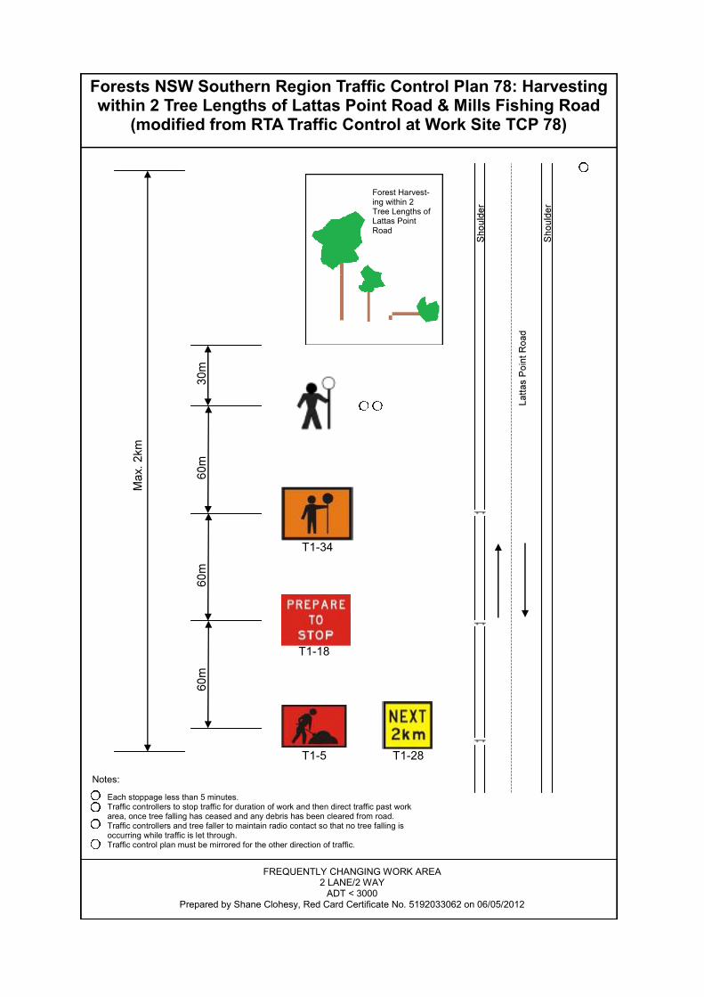
Forests NSW Southern Region Traffic Control Plan 78: Harvesting within 2 Tree Lengths of Lattas Point Road & Mills Fishing Road
(modified from RTA Traffic Control at Work Site TCP 78)
T1-5 T1-28
T1-18
T1-34
Forest Harvest-ing within 2 Tree Lengths of Lattas Point Road
FREQUENTLY CHANGING WORK AREA 2 LANE/2 WAY
ADT < 3000 Prepared by Shane Clohesy, Red Card Certificate No. 5192033062 on 06/05/2012
Each stoppage less than 5 minutes. Traffic controllers to stop traffic for duration of work and then direct traffic past work area, once tree falling has ceased and any debris has been cleared from road. Traffic controllers and tree faller to maintain radio contact so that no tree falling is occurring while traffic is let through. Traffic control plan must be mirrored for the other direction of traffic.
Notes:

Southern Region – Compartment 151, Mogo State Forest, South Coast Management Area
HP_BB_151_12 _v2 04-09-12 9
Silviculture and Harvesting Prescriptions
Year 1944 1948 1951 1962 1964 1970 1980 1986 1988 1991 1994 2000 2004
TSI X X X X X X X X X X X X X
HR Burning X X X X X X X X X X X X √
Wildfires √ √ √ √ √ √ √ √ √ √ √ √ √
Logging m3 0 0 0 0 0 0 0 0 0 0 0 0 0
√ - applies, X – not applicable
Compartment Resource Unit
No. of Sweeps
BA Average (m2/ha)
BA Range (m2/ha)
151 1 10 23 18-34
151 2 4 23 20-26
151 3 11 24 10-32
151 4 2 27 24-30
Silvicultural Planning Single Tree Selection The STS tract (197.5ha) is a predominantly mixed aged mature forest and will be harvested under a light to heavy single tree selection (STS) regime. The objective within the 179ha harvest area for this operation (resource units 1, 2 & 3) is to remove commercially mature and defective trees to create canopy openings for regeneration, whilst retaining and minimising damage to young regenerating stems, seed trees, habitat and recruitment trees.
In order to maintain the visual amenity of the area when viewed from the Batemans Bay township and the Princes Highway additional prescriptions will be applied within the FMZ 3B (visual) areas. Harvesting must be closely monitored by the CC to ensure that the operation is not having a negative visual impact. On the top of the ridges which can be seen from Batemans Bay, particular attention should be payed to the canopy being spaced evenly to avoid the skyline being visually affected. The aim on the ridgelines is to space trees in such a way so as to ensure a continuous canopy height and avoid a “jigsaw” effect. It is envisaged that the next harvesting operation in this compartment would be on average 30 years time.
The STS tract for IFOA purposes includes resource units 1, 2, 3 & 4 of compartment 151 as indicated on the HPOM.
Single Tree Selection (STS) must remove no more than 45% of the basal area (BA), while retaining a minimum BA of 10m2 per hectare within the tract.

Southern Region – Compartment 151, Mogo State Forest, South Coast Management Area
HP_BB_151_12 _v2 04-09-12 10
Resource Unit
(Refer to HPOM for
detail)
Species Composition Stand History Stand Structure and Condition
1 Overstorey dominated by Blackbutt (E. pilularis), Yellow Stringybark (E. muellerana), White Stringybark (E. globoidea) and Spotted Gum (C. maculata). Other species include Sydney Peppermint (E. piperita) and Red Bloodwood (C. gummifera).
• There is very little evidence of previous harvesting in Resource Unit 1 Areas.
• It may be assumed that due to the proximity of this compartment to the Batemans Bay town-ship this area was heavily harvested early on and evidence of cut stumps etc has disappeared through subsequent fire events.
• This area has been subject to numerous wildfires since Europeans settled the area.
• The 2 – 3 age class stands that make up this resource unit are primarily comprised of Mature and Over-mature trees with some small scattered patches of younger regeneration.
• Resource Unit 1 areas are primarily comprised of shade intolerant species such as Blackbutt and the Stringybarks.
• The stand has generally reached endpoint with limited further growth potential.
• Younger cohorts have been suppressed by dominant/co-dominant age class.
2 Overstorey dominated by Blackbutt (E. pilularis), Yellow Stringybark (E. muellerana), White Stringybark (E. globoidea) and Spotted Gum (C. maculata).
• As per Resource Unit 1 • Stand structure is similar to that in Resource Unit 1, however a larger proportion of younger regeneration occurs (particularly on the ridge adjacent to Lattas Point Road).
• Mature (sawlog) trees occur throughout the youngest cohort.
• The younger regeneration would benefit from the creation of canopy openings.
3 Overstorey dominated by
Spotted Gum (C. maculata), Grey Ironbark (E. Paniculata), Blackbutt (E. pilularis), Yellow Stringybark (E. muellerana) and White Stringybark (E. globoidea).
• As per Resource Unit 1 • Some high quality Spotted Gum/Iron Bark stands occur in the southern half of the Resource Unit 3 area.
• Younger cohorts have been suppressed by dominant/co-dominant age class.
4 Overstorey dominated by Spotted Gum (C. maculata), Grey Ironbark (E. Paniculata), Blackbutt (E. pilularis), Yellow Stringybark (E. muellerana) and White Stringybark (E. globoidea). Other species include Sydney Peppermint (E. piperita) and Red Bloodwood (C. gummifera).
• As per Resource Unit 1 • The northern section of the Resource Unit 4 area is quite poor and consists of Bloodwood/Peppermint overstorey with a dense oak understorey.
• The southern section of this Resource Unit is good quality Spotted Gum/Ironbark, however is inaccessible.
• Due to timber quality and inaccessibility this area should be retained as a “Basal Area Bank”.

Southern Region – Compartment 151, Mogo State Forest, South Coast Management Area
HP_BB_151_12 _v2 04-09-12 11
Harvesting Prescription
Resource Unit (Refer to HPOM
for detail)
% of NHA Silvicultural Treatment
1 35% STS Heavy • Retain and protect from harvesting/fire damage:
- habitat and recruitment trees as per TSL, - 4 seed trees/ha (can include other suitable retained trees).
• Retained trees should be evenly spaced throughout the resource unit. • All other trees should be removed markets permitting. If this objective
cannot be achieved the following options should be considered: - reject tree felling (Contract Coordinator must first obtain approval from harvesting team leader),
- defer harvesting until ideal market conditions prevail.
2 20% STS light: • Retain and protect from harvesting/fire damage:
- patches of good quality regeneration (average dbhob <20cm) - habitat and recruitment trees as per TSL, - 4 seed trees/ha (can include other suitable retained trees), - Retain additional trees of good form and vigour to ensure the total BA removal across the Resource Unit is no more than 25%.
• Additional trees may need to be retained throughout this resource unit to ensure no more than 45% of BA is removed and there is a minimum BA retention of 10m2 per hectare within tract.
3 35% STS heavy-Modified Prescription (visual amenity):
• Retain and protect from harvesting/fire damage: - patches of good quality regeneration (average dbhob <20cm) - poles/advanced growth (<40cm DBHOB) with good form and vigour, - habitat and recruitment trees as per TSL, - 4 seed trees/ha (can include other suitable retained trees). - Retain additional trees of good form and vigour to ensure the total BA removal across the Resource Unit is no more than 45%. - Additional trees may need to be retained throughout this resource unit to ensure no more than 45% of BA is removed and there is a minimum BA retention of 10m2 per hectare within tract.
To maintain the visual amenity of the area: • Retained trees should be evenly spaced throughout the resource unit. • Maintain a continuous canopy line along the ridge. • Tree heads should be felled to avoid windrows and minimise the visual
impact. • Retain additional trees around log dumps to minimise visual impact.
4 10% • Retained BA, exclude from harvest due to low viability of the northern
section and access issues of the southern section. Note: The area of each silvicultural treatment must be mapped and recorded in the Post logging information section of this plan.

Southern Region – Compartment 151, Mogo State Forest, South Coast Management Area
HP_BB_151_12 _v2 04-09-12 12
Special Requirements
Non-harvest areas The HPOM indicates the non-harvest areas in the compartments, as detailed in the legend. Harvesting disturbance is not permitted in non-harvest areas unless authorised by the Regional Manager.
Noxious Weeds/Disease/Pests Hygiene Requirements There are no known noxious weeds, pathogens or diseases in the compartment. Harvesting Machinery is not required to be washed down prior to leaving the compartment.
Permanent Growth and Research Plots Any inventory plots located during the harvesting operation are to be treated the same as the surrounding area. Private Property and Critical Boundaries Private property occurs adjacent to the northern and the eastern boundary of the compartment, as indicated on the HPOM. Private property owners have been notified of the scheduled harvesting and post-harvest burning. Contact details are available from the Batemans Bay office. The table below lists neighbours who adjoin Compartment 151:
Name Lot Number
• No harvest disturbance is permitted on private property.
• Harvesting debris must not be left within five metres of the boundary fence lines.
• Any damage to fences must be repaired by the contractor.
• Access roads must be maintained free of debris and in a trafficable state.
Occupation Permits Apiary 5 apiary sites provided in the table below are located within the planning unit as detailed in the table below. Contact details are available from the Batemans Bay office.

Southern Region – Compartment 151, Mogo State Forest, South Coast Management Area
HP_BB_151_12 _v2 04-09-12 13
Name Boundary Location
• The Contract Coordinator must provide the apiary permittees with at least two weeks advance notice when bee boxes need to be removed or relocated.
• A permanent apiary set down site is located at the intersection of Lattas Point Road and Cpt 151/5 Rd (see HPOM). This set down site must be levelled and free of debris at the completion of logging.
• Permanent sites must not be ripped.
Batemans Marine Park The north western boundary of compartment 151 is formed by Pelican Point Sanctuary Zone of the Batemans Marine Park. The Clyde River Habitat Protection Zone of the Batemans Marine Park occurs near the north eastern boundary of the compartment. All drainage features within the compartment are in this catchment and drain into the Clyde River. Refer to FMZ section of this plan for measures to be implemented to protect this zone.
Underground Water Pipe Occupation permit (HSO 3385) for Eurobodalla Shire Council pipelines/pump sites occur within compartment 151. The permit consists of underground pipe lines which run beneath Cpt 151/1 Rd and adjacent to Pipeline Access Track. The lines lead to an above ground tank, north of Mills Fishing Road (shown on HPOM and located in the field with markers).
To prevent damage to the pipes, use directional falling techniques to fall trees away from the pipes. Trucks and harvesting machinery may only cross the pipes where there is minimum depth of cover of 600mm above the pipes.
A field inspection with a Eurobodalla Shire Council representative was conducted to assess the works required before proposed pipe line crossing points can be utilised by trucks and harvesting machinary. Details are provided in the table below.
Location of pipe Is work required to
increase depth of cover to >600mm
Comments
Pipe line runs along entire length of Cpt 151/1 Rd road
line – beneath road pavement.
No This section of pipe line is disused and therefore does not require
minimum depth of 600mm. However incorporate wind rows into pavement when reshaping. DO NOT EXPOSE
ASBESTOS CEMENT PIPE OR DAMAGE THROUGH EXCAVATION.
Pipeline Access Track – Cpt 151/4 Ext Rd intersection
Yes Install 400mm of gravel/soil to road surface at crossing point.
Southern Region – Compartment 151, Mogo State Forest, South Coast Management Area
HP_BB_151_12 _v2 04-09-12 14
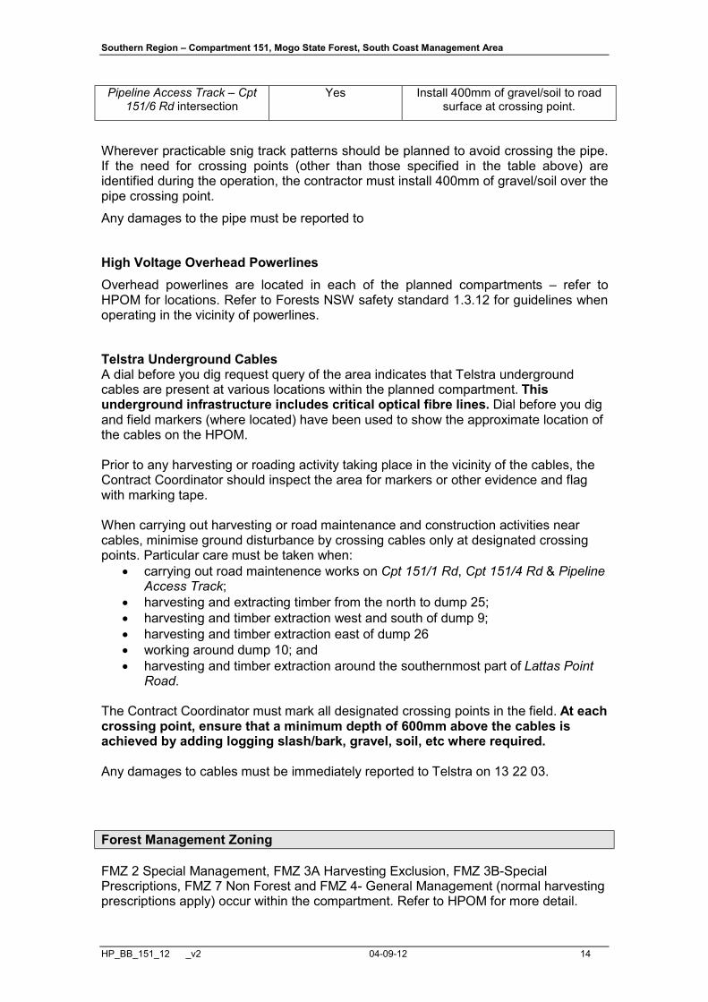
Pipeline Access Track – Cpt 151/6 Rd intersection
Yes Install 400mm of gravel/soil to road surface at crossing point.
Wherever practicable snig track patterns should be planned to avoid crossing the pipe. If the need for crossing points (other than those specified in the table above) are identified during the operation, the contractor must install 400mm of gravel/soil over the pipe crossing point.
Any damages to the pipe must be reported to
High Voltage Overhead Powerlines Overhead powerlines are located in each of the planned compartments – refer to HPOM for locations. Refer to Forests NSW safety standard 1.3.12 for guidelines when operating in the vicinity of powerlines.
Telstra Underground Cables A dial before you dig request query of the area indicates that Telstra underground cables are present at various locations within the planned compartment. This underground infrastructure includes critical optical fibre lines. Dial before you dig and field markers (where located) have been used to show the approximate location of the cables on the HPOM. Prior to any harvesting or roading activity taking place in the vicinity of the cables, the Contract Coordinator should inspect the area for markers or other evidence and flag with marking tape. When carrying out harvesting or road maintenance and construction activities near cables, minimise ground disturbance by crossing cables only at designated crossing points. Particular care must be taken when:
• carrying out road maintenence works on Cpt 151/1 Rd, Cpt 151/4 Rd & Pipeline Access Track;
• harvesting and extracting timber from the north to dump 25; • harvesting and timber extraction west and south of dump 9; • harvesting and timber extraction east of dump 26 • working around dump 10; and • harvesting and timber extraction around the southernmost part of Lattas Point
Road. The Contract Coordinator must mark all designated crossing points in the field. At each crossing point, ensure that a minimum depth of 600mm above the cables is achieved by adding logging slash/bark, gravel, soil, etc where required. Any damages to cables must be immediately reported to Telstra on 13 22 03.
Forest Management Zoning
FMZ 2 Special Management, FMZ 3A Harvesting Exclusion, FMZ 3B-Special Prescriptions, FMZ 7 Non Forest and FMZ 4- General Management (normal harvesting prescriptions apply) occur within the compartment. Refer to HPOM for more detail.

Southern Region – Compartment 151, Mogo State Forest, South Coast Management Area
HP_BB_151_12 _v2 04-09-12 15
FMZ 2 - Special Management (Flora) occurs over marine/wetland vegetation in the northern part of the compartment. Exclusion zones extend 100m east of the Mean High Water Mark of the Clyde River on western side of the compartment and 50m west of the Mean High Water Mark of wetlands on the eastern side of the compartment. Refer to HPOM for detail. These areas also protect the values of the Batemans Marine Park.
Harvesting, harvesting machinary and burning are NOT permitted in the FMZ 2 areas.
The Harvesting Supervisor and Operations Supervisor must liaise during harvesting operations to ensure appropriate control lines are in place to prevent fire entering the FMZ 2 area (this may include snig tracks, felling machine/dozer trail, rake hoe line or fuel moisture differentials).
FMZ 3A – Harvesting Exclusion occurs in the northern section of the compartment. These areas are not visible on the HPOM as they occur beneath the FMZ 2 area that has been extended to protect Batemans Marine Park values.
Harvesting and harvesting machinery are not permitted in these areas.
FMZ 3B (Visual) – Visual protection zones occur throughout the eastern side of compartment 151 due to visibility from Batemans Bay township and the Princes Highway. Harvesting is permitted in these zones under the modified conditions detailed in the harvesting prescriptions section. FMZ 7 – Prescribed burning is only permitted if fire does not conflict with the specific non-forest use of the site. IFOA Required Approval of Forestry Activities
Approvals have not been obtained for snig track construction and/or use and log haulage in FMZ 2/3A. If the Contract Coordinator identifies the need for harvesting related activities to occur within FMZ 2/3A during the operation, the Harvest Planner must be contacted to seek Regional Manager approval. All areas of Rare Non-Commercial Forest Ecosystems require prior OEH approval and Stream Exclusion Zones require prior Regional Manager approval before forest harvesting related activities (eg: road or snig track construction & reopening) can be undertaken. It is the responsibility of the Contract Coordinator to identify any exclusion areas which will need to be crossed during harvesting. The Contract Coordinator should then contact the Harvest Planner to obtain the necessary approval. Cultural Heritage
Cultural Heritage - There is Cultural Heritage site within the compartment and sites within close proximity to the boundary of the compartment. All relevant representatives have been consulted &/or inspected compartment 151. Due to the confidentiality of the Cultural Heritage sites, a Cultural Heritage site map will only be attached to the specific copies of the plan. All 10 metre radius exclusion buffers are to be marked in the field as hard exclusion zones (i.e. pink & yellow tape) where logging and/or road works are scheduled to be undertaken. All operators must be taken to each site within the planned area before any activities are commenced.
Southern Region – Compartment 151, Mogo State Forest, South Coast Management Area
HP_BB_151_12 _v2 04-09-12 16
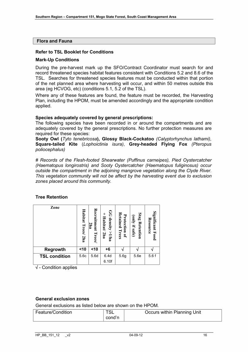
Flora and Fauna
Refer to TSL Booklet for Conditions Mark-Up Conditions During the pre-harvest mark up the SFO/Contract Coordinator must search for and record threatened species habitat features consistent with Conditions 5.2 and 8.6 of the TSL. Searches for threatened species features must be conducted within that portion of the net planned area where harvesting will occur, and within 50 metres outside this area (eg HCVOG, etc) (conditions 5.1, 5.2 of the TSL). Where any of these features are found, the feature must be recorded, the Harvesting Plan, including the HPOM, must be amended accordingly and the appropriate condition applied. Species adequately covered by general prescriptions: The following species have been recorded in or around the compartments and are adequately covered by the general prescriptions. No further protection measures are required for these species: Sooty Owl (Tyto tenebricosa), Glossy Black-Cockatoo (Calyptorhynchus lathami), Square-tailed Kite (Lophoictinia isura), Grey-headed Flying Fox (Pteropus poliocephalus) # Records of the Flesh-footed Shearwater (Puffinus carneipes), Pied Oystercatcher (Haematopus longirostris) and Sooty Oystercatcher (Haematopus fuliginosus) occur outside the compartment in the adjoining mangrove vegetation along the Clyde River. This vegetation community will not be affect by the harvesting event due to exclusion zones placed around this community. Tree Retention
Zone Habitat Trees/ 2ha
Recruitm
ent Trees/ 2ha
GG
density >1/ha + H
abitat/ 2ha
Protection of R
etained Trees
Stag Retention
(only if safe)
Significant Food R
esource
Regrowth <10 <10 +6 √ √ √ TSL condition 5.6c 5.6d 6.4d
6.10f 5.6g 5.6e 5.6 f
√ - Condition applies General exclusion zones General exclusions as listed below are shown on the HPOM. Feature/Condition TSL
cond’n Occurs within Planning Unit

Southern Region – Compartment 151, Mogo State Forest, South Coast Management Area
HP_BB_151_12 _v2 04-09-12 17
Rainforest 5.4 No Rare Non Commercial Forest Ecosystems
5.5 Yes (not visible on HPOM – located beneath FMZ 2 area)
Riparian Protection Zones 5.7 Yes Ridge & Headwater Habitat 5.8 Yes (80m total width) Wetlands 5.9 Yes (not visible on HPOM – located beneath
FMZ 2 area) Heath and Scrub 5.10 No Rocky Outcrops and Cliffs 5.11 No Endangered Ecological Community
NA Yes – Areas of 1 - River-flat Eucalypt Forest on Coastal Floodplains of NSW North Coast, Sydney Basin & South Coast Bioregions, 2 - Swamp Oak
Floodplain Forest of the NSW North Coast, Sydney Basin & South Coast Bioregions & 3 - Coastal Saltmarsh in the NSW North Coast,
Sydney Basin & South Coast Bioregions have been identified within compartment 151. Indicative boundaries are mapped on the HPOM. SFO/CC
to assess EEC extent during regular mark-up using the relevant EEC Identification Guidelines.
All areas of EEC must be excluded from harvesting & burning.
General Threatened Flora and Fauna Prescriptions
Feature Records in 151 Licence conditions under the TSC Act
Threatened Frog General Protection Measures
No 5.12
Bird Nest and Roost Site Protection
No 5.13
Tree Bat Roost Protection No 5.14.1 Subterranean Roost
Protection No 5.14.2
Significant Subterranean Roost Protection
No 5.14.3
Protection of flying-fox Camps
No 5.14.4
Burning Net planned area 5.16 Ground Habitat Protection Net planned area 5.17
Species & Site-Specific Threatened Flora and Fauna Prescriptions Contractors and supervisory staff must immediately report any sightings of Schedule 1 and 2 species to the Harvesting Team Leader. The Harvesting Plan must be amended to include additional prescriptions if necessary.
The following species have been recorded within or nearby the area and the associated prescriptions must be implemented:

Southern Region – Compartment 151, Mogo State Forest, South Coast Management Area
HP_BB_151_12 _v2 04-09-12 18
Threatened species and habitat features within trigger distance
Records in 151
Licence conditions under the TSC Act or relevant Site-
specific prescription Masked Owl, Tyto novaehollandie. No 6.4 Swift Parrot, Lathamus discolor No 6.5 Koala, Phascolarctos cinereus No 6.11 Yellow-bellied Glider, Petaurus australis Yes 6.13
Little Lorikeet, Glossopsitta pusilla Yes Refer to Condition 5.13(a) & (h) for Turquoise Parrot.
30m exclusion zone around all nests. Burning not permitted in
exclusion zones. Post-harvest burning within
compartment 151 may only be conducted outside nesting period (exclude burning between 1st May
& 1st September). Varied Sittella, Daphoenositta chrysoptera Yes Refer to Condition 5.13(a) & (h)
for Regent Honeyeater & Condition 5.17 (b).
20m exclusion zone around all nests.
Gang-gang Cockatoo, Callocephalon fimbriatum
No Inform ecologist immediately if this species is detected within the compartments or within 100m of
the compartment boundary. Little Eagle, Hieraaetus morphnoides No Inform ecologist immediately if
this species is detected within the compartments or within 100m of
the compartment boundary. Fisheries Licence Conditions
There are no known records of threatened fish species or class 1 or 2 aquatic habitat relevant to this operation. The conditions of the fisheries licence are not triggered for this operation. Soils and Water Protection
Refer to EPL Booklet & Standard Plan Conditions Site-specific EPL Conditions
Elements Conditions
Unmapped Drainage Lines EPL applies. Drainage Feature Protection See HPOM for widths
Inherent Hazard Class 2
Southern Region – Compartment 151, Mogo State Forest, South Coast Management Area
HP_BB_151_12 _v2 04-09-12 19
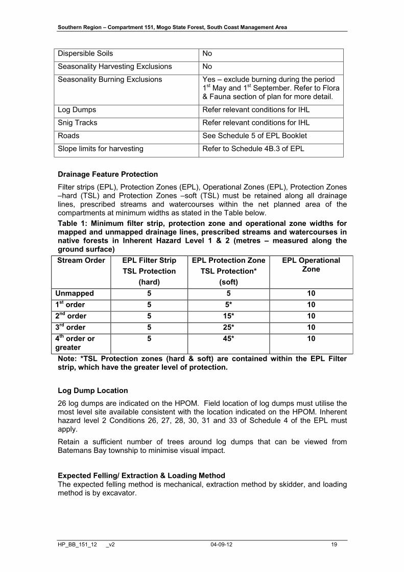
Dispersible Soils No
Seasonality Harvesting Exclusions No
Seasonality Burning Exclusions Yes – exclude burning during the period 1st May and 1st September. Refer to Flora & Fauna section of plan for more detail.
Log Dumps Refer relevant conditions for IHL
Snig Tracks Refer relevant conditions for IHL
Roads See Schedule 5 of EPL Booklet
Slope limits for harvesting Refer to Schedule 4B.3 of EPL
Drainage Feature Protection
Filter strips (EPL), Protection Zones (EPL), Operational Zones (EPL), Protection Zones –hard (TSL) and Protection Zones –soft (TSL) must be retained along all drainage lines, prescribed streams and watercourses within the net planned area of the compartments at minimum widths as stated in the Table below. Table 1: Minimum filter strip, protection zone and operational zone widths for mapped and unmapped drainage lines, prescribed streams and watercourses in native forests in Inherent Hazard Level 1 & 2 (metres – measured along the ground surface) Stream Order EPL Filter Strip
TSL Protection (hard)
EPL Protection Zone TSL Protection*
(soft)
EPL Operational Zone
Unmapped 5 5 10 1st order 5 5* 10 2nd order 5 15* 10 3rd order 5 25* 10 4th order or greater
5 45* 10
Note: *TSL Protection zones (hard & soft) are contained within the EPL Filter strip, which have the greater level of protection.
Log Dump Location 26 log dumps are indicated on the HPOM. Field location of log dumps must utilise the most level site available consistent with the location indicated on the HPOM. Inherent hazard level 2 Conditions 26, 27, 28, 30, 31 and 33 of Schedule 4 of the EPL must apply. Retain a sufficient number of trees around log dumps that can be viewed from Batemans Bay township to minimise visual impact.
Expected Felling/ Extraction & Loading Method The expected felling method is mechanical, extraction method by skidder, and loading method is by excavator.
Southern Region – Compartment 151, Mogo State Forest, South Coast Management Area
HP_BB_151_12 _v2 04-09-12 20
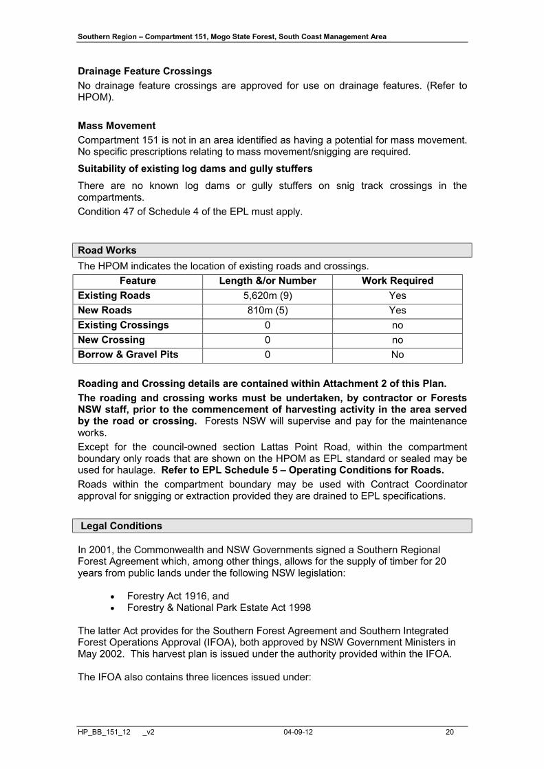
Drainage Feature Crossings No drainage feature crossings are approved for use on drainage features. (Refer to HPOM). Mass Movement Compartment 151 is not in an area identified as having a potential for mass movement. No specific prescriptions relating to mass movement/snigging are required.
Suitability of existing log dams and gully stuffers There are no known log dams or gully stuffers on snig track crossings in the compartments. Condition 47 of Schedule 4 of the EPL must apply. Road Works The HPOM indicates the location of existing roads and crossings.
Feature Length &/or Number Work Required Existing Roads 5,620m (9) Yes New Roads 810m (5) Yes Existing Crossings 0 no New Crossing 0 no Borrow & Gravel Pits 0 No Roading and Crossing details are contained within Attachment 2 of this Plan. The roading and crossing works must be undertaken, by contractor or Forests NSW staff, prior to the commencement of harvesting activity in the area served by the road or crossing. Forests NSW will supervise and pay for the maintenance works. Except for the council-owned section Lattas Point Road, within the compartment boundary only roads that are shown on the HPOM as EPL standard or sealed may be used for haulage. Refer to EPL Schedule 5 – Operating Conditions for Roads. Roads within the compartment boundary may be used with Contract Coordinator approval for snigging or extraction provided they are drained to EPL specifications. Legal Conditions
In 2001, the Commonwealth and NSW Governments signed a Southern Regional Forest Agreement which, among other things, allows for the supply of timber for 20 years from public lands under the following NSW legislation:
• Forestry Act 1916, and • Forestry & National Park Estate Act 1998
The latter Act provides for the Southern Forest Agreement and Southern Integrated Forest Operations Approval (IFOA), both approved by NSW Government Ministers in May 2002. This harvest plan is issued under the authority provided within the IFOA. The IFOA also contains three licences issued under:

Southern Region – Compartment 151, Mogo State Forest, South Coast Management Area
HP_BB_151_12 _v2 04-09-12 21
• Section 55 of the Protection of the Environment Act 1997 (EPL) • Threatened Species Conservation Act 1995 (TSL). • Section 220ZW of the Fisheries Management Act 1994 (FL).
This harvest plan will be managed in the field under:
• Licences issued under the Forestry Act (1916) • Forest Practices Code part 2 (Timber Harvesting in Native Forests – 1999)
and part 4 (Forest Roads and Fire Trails – 1999) • Standard Harvest Plan Conditions for Native Forest Operations Under the
IFOA, Southern Region-South Coast Area. Harvesting operations must comply with all of the above Licences and the Code (unless otherwise specified). Further information is available from http://www.environment.nsw.gov.au/
Southern Region – Compartment 151, Mogo State Forest, South Coast Management Area
HP_BB_151_12 _v2 04-09-12 22
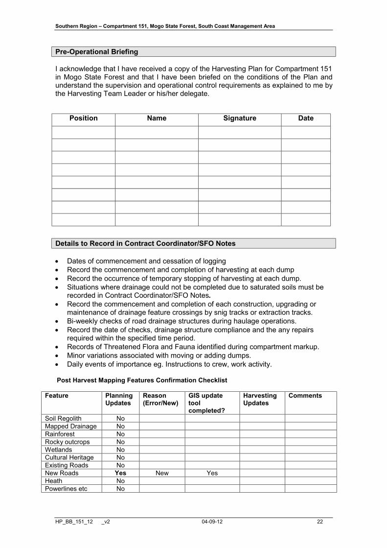
Pre-Operational Briefing
I acknowledge that I have received a copy of the Harvesting Plan for Compartment 151 in Mogo State Forest and that I have been briefed on the conditions of the Plan and understand the supervision and operational control requirements as explained to me by the Harvesting Team Leader or his/her delegate.
Position Name Signature Date
Details to Record in Contract Coordinator/SFO Notes
• Dates of commencement and cessation of logging • Record the commencement and completion of harvesting at each dump • Record the occurrence of temporary stopping of harvesting at each dump. • Situations where drainage could not be completed due to saturated soils must be
recorded in Contract Coordinator/SFO Notes. • Record the commencement and completion of each construction, upgrading or
maintenance of drainage feature crossings by snig tracks or extraction tracks. • Bi-weekly checks of road drainage structures during haulage operations. • Record the date of checks, drainage structure compliance and the any repairs
required within the specified time period. • Records of Threatened Flora and Fauna identified during compartment markup. • Minor variations associated with moving or adding dumps. • Daily events of importance eg. Instructions to crew, work activity. Post Harvest Mapping Features Confirmation Checklist
Feature Planning Updates
Reason (Error/New)
GIS update tool completed?
Harvesting Updates
Comments
Soil Regolith No Mapped Drainage No Rainforest No Rocky outcrops No Wetlands No Cultural Heritage No Existing Roads No New Roads Yes New Yes Heath No Powerlines etc No

Southern Region – Compartment 151, Mogo State Forest, South Coast Management Area
HP_BB_151_12 _v2 04-09-12 23
Contract Coordinator Feature Usage Record
Dates of commencement and cessation of logging Date of commencement of logging: _____________
Date of cessation of logging: __________________
DUMP USAGE RECORD • Record the commencement and completion of harvesting at each dump • Record the occurrence of temporary stopping of harvesting at each dump.
Dump
number Start date
Finish date
*Track drainage
completed within 2 days
(yes/no)
Date of temporary cessation
**Temporary track drainage completed
within 5 days (yes/no)
Date resumed
*At completion of snig track/dump, track drainage must be completed within 2 days unless soil is saturated.
*At temporary cessation of snig track use, track drainage must be completed within 5 days unless soil is saturated.
Situations where drainage could not be completed due to saturated soils must be recorded in Contract Coordinator/SFO Notes.

Southern Region – Compartment 151, Mogo State Forest, South Coast Management Area
HP_BB_151_12 _v2 04-09-12 24
Contract Coordinator/SFO Notes
Date Event Signed

Southern Region – Compartment 151, Mogo State Forest, South Coast Management Area
HP_BB_151_12 _v2 04-09-12 25
Contract Coordinator/SFO Notes (continued) Date Event Signed

Southern Region – Compartment 151, Mogo State Forest, South Coast Management Area
HP_BB_151_12 _v2 04-09-12 26
Contract Coordinator/SFO Notes (continued) Date Event Signed

Southern Region – Compartment 151, Mogo State Forest, South Coast Management Area
HP_BB_151_12 _v2 04-09-12 27
Contract Coordinator/SFO Notes (continued) Date Event Signed

Southern Region – Compartment 151, Mogo State Forest, South Coast Management Area
HP_BB_151_12 _v2 04-09-12 28
Contract Coordinator/SFO Notes (continued) Date Event Signed
Southern Region – Compartment 151, Mogo State Forest, South Coast Management Area
HP_BB_151_12 _v2 04-09-12 29
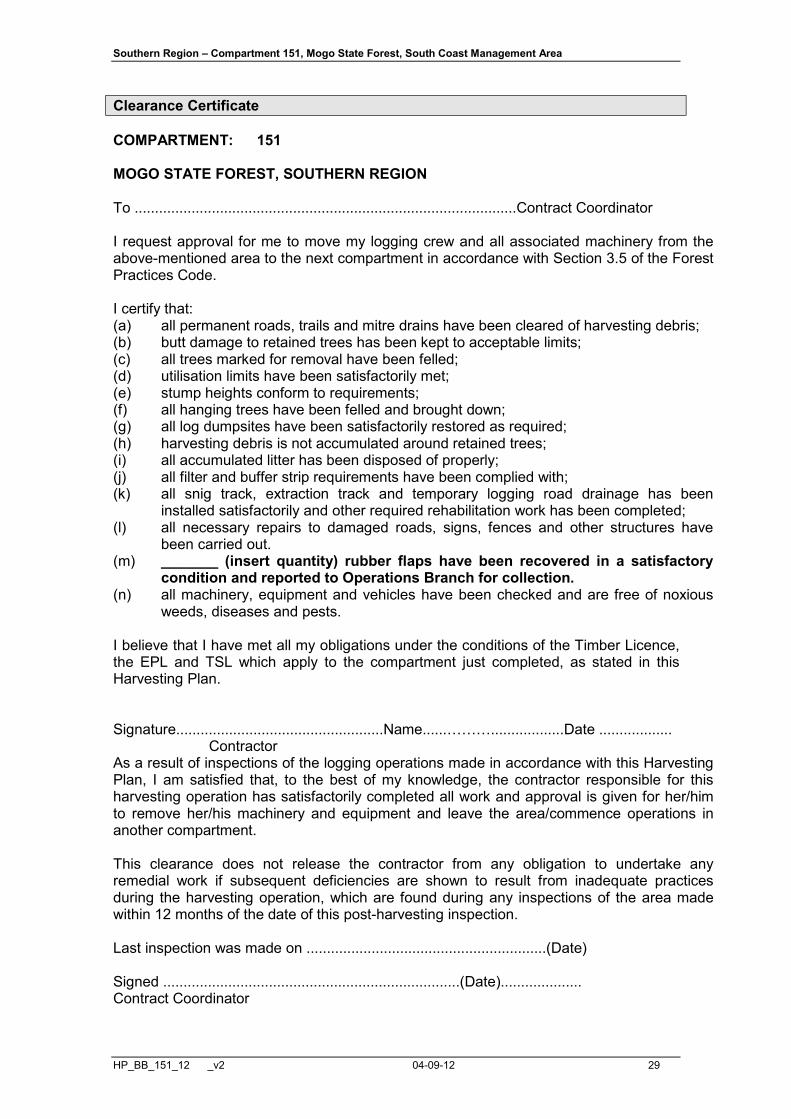
Clearance Certificate
COMPARTMENT: 151 MOGO STATE FOREST, SOUTHERN REGION To ..............................................................................................Contract Coordinator I request approval for me to move my logging crew and all associated machinery from the above-mentioned area to the next compartment in accordance with Section 3.5 of the Forest Practices Code. I certify that: (a) all permanent roads, trails and mitre drains have been cleared of harvesting debris; (b) butt damage to retained trees has been kept to acceptable limits; (c) all trees marked for removal have been felled; (d) utilisation limits have been satisfactorily met; (e) stump heights conform to requirements; (f) all hanging trees have been felled and brought down; (g) all log dumpsites have been satisfactorily restored as required; (h) harvesting debris is not accumulated around retained trees; (i) all accumulated litter has been disposed of properly; (j) all filter and buffer strip requirements have been complied with; (k) all snig track, extraction track and temporary logging road drainage has been
installed satisfactorily and other required rehabilitation work has been completed; (l) all necessary repairs to damaged roads, signs, fences and other structures have
been carried out. (m) _______ (insert quantity) rubber flaps have been recovered in a satisfactory
condition and reported to Operations Branch for collection. (n) all machinery, equipment and vehicles have been checked and are free of noxious
weeds, diseases and pests. I believe that I have met all my obligations under the conditions of the Timber Licence, the EPL and TSL which apply to the compartment just completed, as stated in this Harvesting Plan. Signature...................................................Name......………..................Date .................. Contractor As a result of inspections of the logging operations made in accordance with this Harvesting Plan, I am satisfied that, to the best of my knowledge, the contractor responsible for this harvesting operation has satisfactorily completed all work and approval is given for her/him to remove her/his machinery and equipment and leave the area/commence operations in another compartment. This clearance does not release the contractor from any obligation to undertake any remedial work if subsequent deficiencies are shown to result from inadequate practices during the harvesting operation, which are found during any inspections of the area made within 12 months of the date of this post-harvesting inspection. Last inspection was made on ...........................................................(Date) Signed .........................................................................(Date).................... Contract Coordinator

Southern Region – Compartment 151, Mogo State Forest, South Coast Management Area
HP_BB_151_12 _v2 04-09-12 30
Post Logging Information
Record any circumstances of significance relating to the harvesting of this compartment. Please draw or include any annotations on the attached operation scale map. Summary of silvicultural treatment
Treatment type Area (ha) subject to treatment
(Contract Coordinator estimate)
Number of AGS gaps created
Comments
Australian Group Selection Single Tree Selection Thinning/Spacing Post Harvest Silviculture Actual area harvested (record on attached HPOM)
Give reasons for harvestable areas that were not harvested (eg. Too steep, defective timber). Make reference to map.
Post Logging Basal Area sweeps
Dump No# Sweep 1 Sweep 2 Sweep 3 Sweep 4 Average Post BA Average m2/ha Pre BA Average 24.5 m2/ha
Comply with maximum STS BA removal of 45% or Thinning BA removal of 60% Y/N
Possible next cut (tick appropriate boxes)
Main product type Anticipated volume Time to next harvest H M L 0 to 5 years Girders 5 to 10 years Veneer 10 to 20 years Poles/piles 20 to 30 years Quota 30 plus years Smalls/Thinnings Salvage Pulpwood/chipwood
Southern Region – Compartment 151, Mogo State Forest, South Coast Management Area
HP_BB_151_12 _v2 04-09-12 31
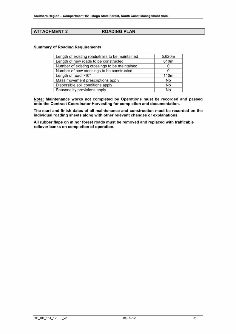
ATTACHMENT 2 ROADING PLAN
Summary of Roading Requirements
Length of existing roads/trails to be maintained 5,620m Length of new roads to be constructed 810m Number of existing crossings to be maintained 0 Number of new crossings to be constructed 0 Length of road >10° 110m Mass movement prescriptions apply No Dispersible soil conditions apply No Seasonality provisions apply No
Note: Maintenance works not completed by Operations must be recorded and passed onto the Contract Coordinator Harvesting for completion and documentation.
The start and finish dates of all maintenance and construction must be recorded on the individual roading sheets along with other relevant changes or explanations.
All rubber flaps on minor forest roads must be removed and replaced with trafficable rollover banks on completion of operation.
Southern Region – Compartment 151, Mogo State Forest, South Coast Management Area
HP_BB_151_12 _v2 04-09-12 32
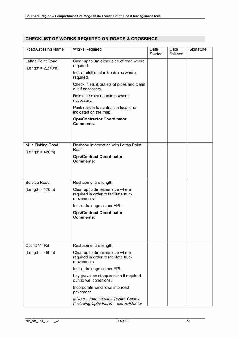
CHECKLIST OF WORKS REQUIRED ON ROADS & CROSSINGS
Road/Crossing Name Works Required Date Started
Date finished
Signature
Lattas Point Road
(Length = 2,270m)
Clear up to 3m either side of road where required.
Install additional mitre drains where required.
Check inlets & outlets of pipes and clean out if necessary.
Reinstate existing mitres where necessary.
Pack rock in table drain in locations indicated on the map.
Ops/Contractor Coordinator Comments:
Mills Fishing Road
(Length = 460m)
Reshape intersection with Lattas Point Road.
Ops/Contract Coordinator Comments:
Service Road
(Length = 170m)
Reshape entire length.
Clear up to 3m either side where required in order to facilitate truck movements.
Install drainage as per EPL.
Ops/Contract Coordinator Comments:
Cpt 151/1 Rd
(Length = 480m)
Reshape entire length.
Clear up to 3m either side where required in order to facilitate truck movements.
Install drainage as per EPL.
Lay gravel on steep section if required during wet conditions.
Incorporate wind rows into road pavement.
# Note – road crosses Telstra Cables (including Optic Fibre) – see HPOM for

Southern Region – Compartment 151, Mogo State Forest, South Coast Management Area
HP_BB_151_12 _v2 04-09-12 33
indicative location. Build up road pavement to at least 60cm depth over cable at crossing points.
# Note – disused asbestos cement water pipe runs along road line (beneath road pavement). DO NOT EXPOSE OR DAMAGE THROUGH EXCAVATION.
Ops/Contract Coordinator Comments:
Cpt 151/2 Rd
(Length = 300m)
Reshape entire length.
Clear up to 3m either side where required in order to facilitate truck movements.
Install drainage as per EPL.
Ops/Contract Coordinator Comments:
Cpt 151/3 Rd
(Length = 800m)
Reshape entire length.
Clear up to 3m either side where required to facilitate truck movements.
Install drainage as per EPL.
Ops/Contract Coordinator Comments:
Cpt 151/4 Rd
(Length = 590m)
Reshape entire length.
Clear up to 3m either side where required to facilitate truck movements.
Install drainage as per EPL.
# Note – road crosses Telstra Cables (including Optic Fibre) – see HPOM for indicative location. Build up road pavement to at least 60cm depth over cable at crossing point.
Ops/Contract Coordinator Comments:

Southern Region – Compartment 151, Mogo State Forest, South Coast Management Area
HP_BB_151_12 _v2 04-09-12 34
Cpt 151/4 Ext Rd
(Length = 140m)
Refer to New Road Construction form.
# Note – road crosses Eurobodalla Shire Council Waterpipe – see HPOM for indicative location. Build up road pavement to at least 60cm depth over water pipe at crossing point.
Ops/Contract Coordinator Comments:
Pipeline Access Track
(Length = 250m)
Reshape entire length and widen road pavement.
Clear up to 3m either side to facilitate truck movements.
Install drainage as per EPL.
Install drop down structures and dissipaters as per EPL to ensure that erosion does not occur on the old road line cutting below Pipeline Access Road.
Ops/Contract Coordinator Comments:
Cpt 151/6 Rd
(Length = 150m)
Reshape entire length and widen road pavement.
Clear up to 3m either side to facilitate truck movements.
Install drainage (rubber flaps and mitres) as per EPL.
# Note – road crosses Eurobodalla Shire Council Waterpipe – see HPOM for indicative location. Build up road pavement to at least 60cm depth over water pipe at crossing point.
Ops/Contract Coordinator Comments:
Cpt 151/7 Rd
(Length = 220m)
Refer to attached New Road Construction Form.
# Note – Use directional felling techniques when clearing road line within 2 x Tree Lengths of overhead powerlines. Exercise extreme caution.
Ops/Contract Coordinator Comments:
Southern Region – Compartment 151, Mogo State Forest, South Coast Management Area
HP_BB_151_12 _v2 04-09-12 35
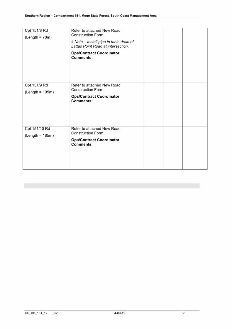
Cpt 151/8 Rd
(Length = 70m)
Refer to attached New Road Construction Form.
# Note – Install pipe in table drain of Lattas Point Road at intersection.
Ops/Contract Coordinator Comments:
Cpt 151/9 Rd
(Length = 195m)
Refer to attached New Road Construction Form.
Ops/Contract Coordinator Comments:
Cpt 151/10 Rd
(Length = 185m)
Refer to attached New Road Construction Form.
Ops/Contract Coordinator Comments:

Southern Region – Compartment 151, Mogo State Forest, South Coast Management Area
HP_BB_151_12 _v2 04-09-12 36
NEW ROAD CONSTRUCTION
Cpt 151/4 Ext Rd Features Road Specifications Additional instructions /
Materials Road Length (m) 140 m Max. Width of road prism (m) 4 m Max. Road grade (length road >10 degrees?)
11 degrees (~20m)
Max. Ground slope (length road >30 degrees?)
Nil
Max. Height of cut / fill batters (m)
Nil
Max length of batters (m) N/A Type of sediment trapping / soil erosion/ sediment control device to be used during construction
Natural surrounding vegetation supplemented with silt fencing, seed and mulch as required.
Contract Coordinator to monitor during road construction and assess requirements.
Recommended road drainage type
Recommend rubber flaps if >5 degrees. Rollovers or mitres if < or = 5 degrees. Contract Coordinator to measure & mark in the field in accordance to Sch. 5 Table 1 of the EPL. Trafficable rollovers to be installed upon harvest completion.
Rubber flaps during operation. Permanent trafficable rollovers to be installed upon completion of use.
Spacing of road structures to be installed
As per EPL Sch. 5, Section C, Table 1
Soil erosion / sediment control techniques
Drainage outlets must drain onto stable surface which provides efficient sediment trapping & energy dissipation. Upon harvest completion, logging debris is to be removed from table and mitre drains so they are left in effective working order.
Seed & mulch as required
Stabilisation assessment intervals
As per EPL Sch. 5, Clause 5, 15, 17, 19 & 20
Drop down & dissipater required Not required.
Soil stabilisation techniques of disturbed areas
Seed & mulch as required
Mass movement / dispersible soils
Nil
Final road use Retain Start Date Finish Date Note: Maintenance works not completed by Operations must be recorded and passed on to the Contract Coordinator.

Southern Region – Compartment 151, Mogo State Forest, South Coast Management Area
HP_BB_151_12 _v2 04-09-12 37
This page is intentionally left blank (removal of new road 151/6 Road from plan).
Southern Region – Compartment 151, Mogo State Forest, South Coast Management Area
HP_BB_151_12 _v2 04-09-12 38
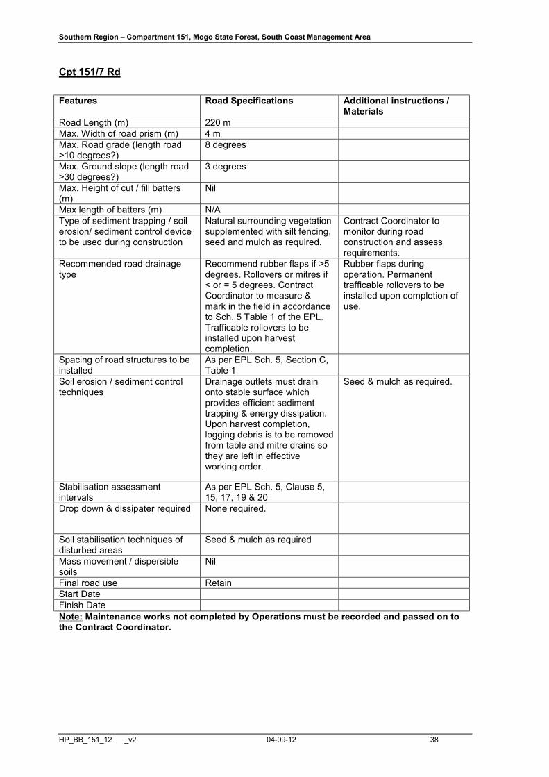
Cpt 151/7 Rd Features Road Specifications Additional instructions /
Materials Road Length (m) 220 m Max. Width of road prism (m) 4 m Max. Road grade (length road >10 degrees?)
8 degrees
Max. Ground slope (length road >30 degrees?)
3 degrees
Max. Height of cut / fill batters (m)
Nil
Max length of batters (m) N/A Type of sediment trapping / soil erosion/ sediment control device to be used during construction
Natural surrounding vegetation supplemented with silt fencing, seed and mulch as required.
Contract Coordinator to monitor during road construction and assess requirements.
Recommended road drainage type
Recommend rubber flaps if >5 degrees. Rollovers or mitres if < or = 5 degrees. Contract Coordinator to measure & mark in the field in accordance to Sch. 5 Table 1 of the EPL. Trafficable rollovers to be installed upon harvest completion.
Rubber flaps during operation. Permanent trafficable rollovers to be installed upon completion of use.
Spacing of road structures to be installed
As per EPL Sch. 5, Section C, Table 1
Soil erosion / sediment control techniques
Drainage outlets must drain onto stable surface which provides efficient sediment trapping & energy dissipation. Upon harvest completion, logging debris is to be removed from table and mitre drains so they are left in effective working order.
Seed & mulch as required.
Stabilisation assessment intervals
As per EPL Sch. 5, Clause 5, 15, 17, 19 & 20
Drop down & dissipater required None required.
Soil stabilisation techniques of disturbed areas
Seed & mulch as required
Mass movement / dispersible soils
Nil
Final road use Retain Start Date Finish Date Note: Maintenance works not completed by Operations must be recorded and passed on to the Contract Coordinator.
Southern Region – Compartment 151, Mogo State Forest, South Coast Management Area
HP_BB_151_12 _v2 04-09-12 39
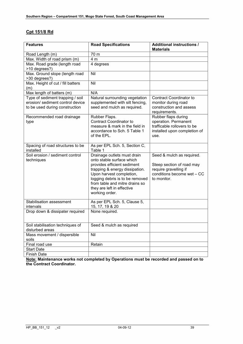
Cpt 151/8 Rd Features Road Specifications Additional instructions /
Materials Road Length (m) 70 m Max. Width of road prism (m) 4 m Max. Road grade (length road >10 degrees?)
4 degrees
Max. Ground slope (length road >30 degrees?)
Nil
Max. Height of cut / fill batters (m)
Nil
Max length of batters (m) N/A Type of sediment trapping / soil erosion/ sediment control device to be used during construction
Natural surrounding vegetation supplemented with silt fencing, seed and mulch as required.
Contract Coordinator to monitor during road construction and assess requirements.
Recommended road drainage type
Rubber Flaps. Contract Coordinator to measure & mark in the field in accordance to Sch. 5 Table 1 of the EPL.
Rubber flaps during operation. Permanent trafficable rollovers to be installed upon completion of use.
Spacing of road structures to be installed
As per EPL Sch. 5, Section C, Table 1
Soil erosion / sediment control techniques
Drainage outlets must drain onto stable surface which provides efficient sediment trapping & energy dissipation. Upon harvest completion, logging debris is to be removed from table and mitre drains so they are left in effective working order.
Seed & mulch as required. Steep section of road may require gravelling if conditions become wet – CC to monitor.
Stabilisation assessment intervals
As per EPL Sch. 5, Clause 5, 15, 17, 19 & 20
Drop down & dissipater required None required.
Soil stabilisation techniques of disturbed areas
Seed & mulch as required
Mass movement / dispersible soils
Nil
Final road use Retain Start Date Finish Date Note: Maintenance works not completed by Operations must be recorded and passed on to the Contract Coordinator.
Southern Region – Compartment 151, Mogo State Forest, South Coast Management Area
HP_BB_151_12 _v2 04-09-12 40
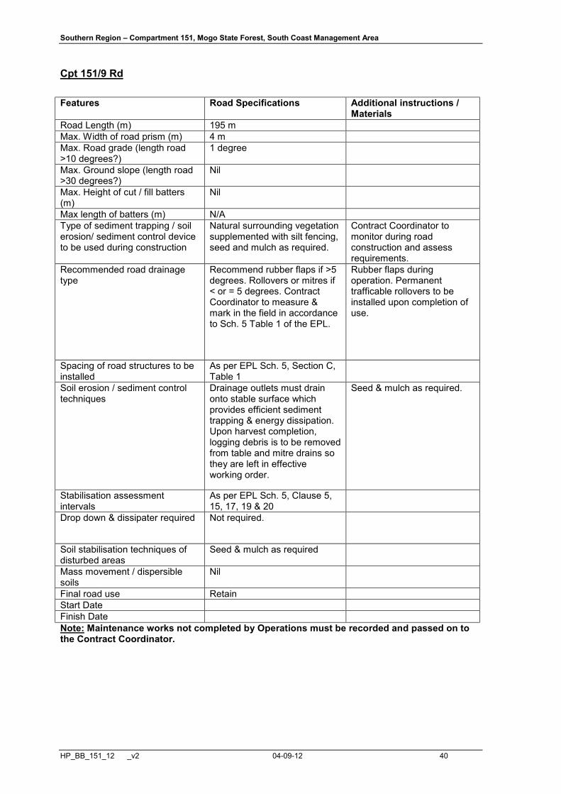
Cpt 151/9 Rd Features Road Specifications Additional instructions /
Materials Road Length (m) 195 m Max. Width of road prism (m) 4 m Max. Road grade (length road >10 degrees?)
1 degree
Max. Ground slope (length road >30 degrees?)
Nil
Max. Height of cut / fill batters (m)
Nil
Max length of batters (m) N/A Type of sediment trapping / soil erosion/ sediment control device to be used during construction
Natural surrounding vegetation supplemented with silt fencing, seed and mulch as required.
Contract Coordinator to monitor during road construction and assess requirements.
Recommended road drainage type
Recommend rubber flaps if >5 degrees. Rollovers or mitres if < or = 5 degrees. Contract Coordinator to measure & mark in the field in accordance to Sch. 5 Table 1 of the EPL.
Rubber flaps during operation. Permanent trafficable rollovers to be installed upon completion of use.
Spacing of road structures to be installed
As per EPL Sch. 5, Section C, Table 1
Soil erosion / sediment control techniques
Drainage outlets must drain onto stable surface which provides efficient sediment trapping & energy dissipation. Upon harvest completion, logging debris is to be removed from table and mitre drains so they are left in effective working order.
Seed & mulch as required.
Stabilisation assessment intervals
As per EPL Sch. 5, Clause 5, 15, 17, 19 & 20
Drop down & dissipater required Not required.
Soil stabilisation techniques of disturbed areas
Seed & mulch as required
Mass movement / dispersible soils
Nil
Final road use Retain Start Date Finish Date Note: Maintenance works not completed by Operations must be recorded and passed on to the Contract Coordinator.
Southern Region – Compartment 151, Mogo State Forest, South Coast Management Area
HP_BB_151_12 _v2 04-09-12 41
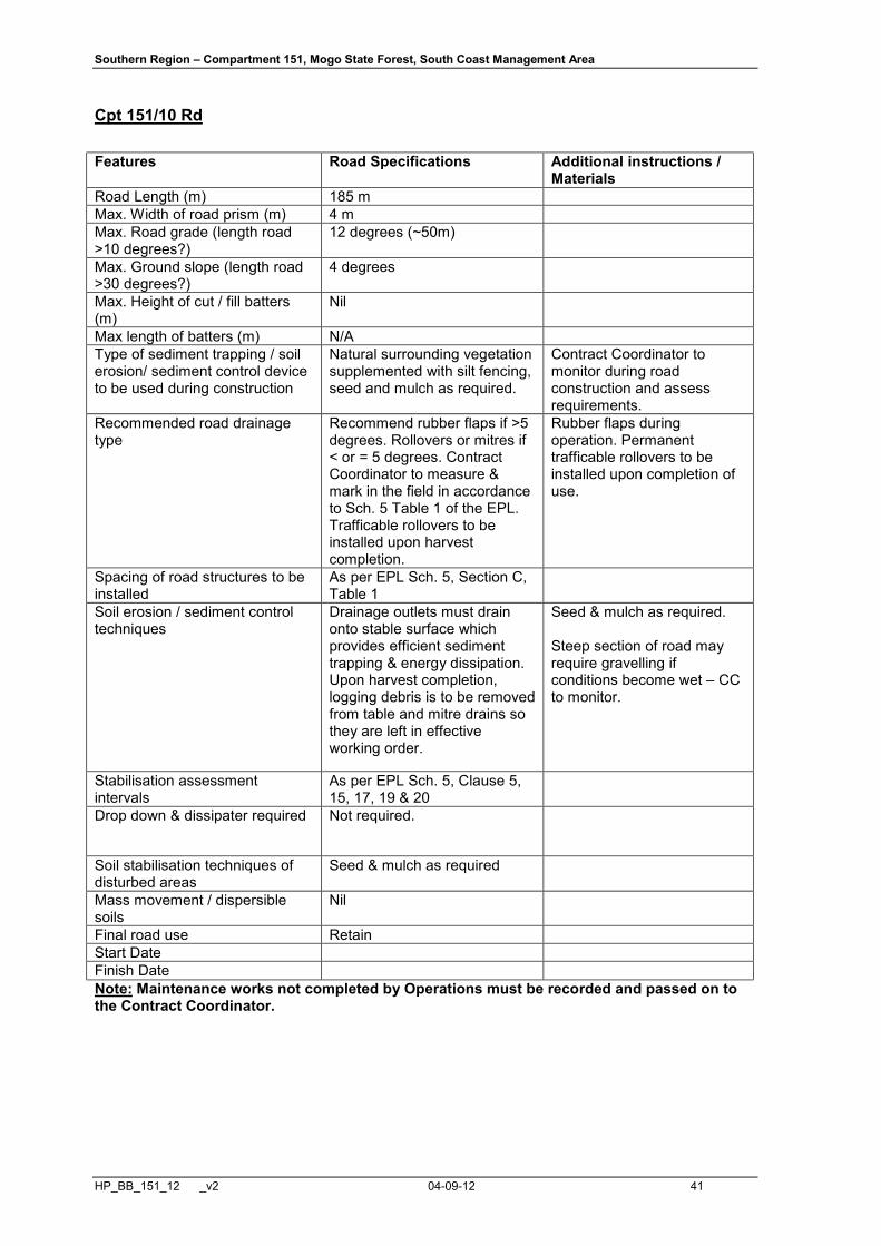
Cpt 151/10 Rd Features Road Specifications Additional instructions /
Materials Road Length (m) 185 m Max. Width of road prism (m) 4 m Max. Road grade (length road >10 degrees?)
12 degrees (~50m)
Max. Ground slope (length road >30 degrees?)
4 degrees
Max. Height of cut / fill batters (m)
Nil
Max length of batters (m) N/A Type of sediment trapping / soil erosion/ sediment control device to be used during construction
Natural surrounding vegetation supplemented with silt fencing, seed and mulch as required.
Contract Coordinator to monitor during road construction and assess requirements.
Recommended road drainage type
Recommend rubber flaps if >5 degrees. Rollovers or mitres if < or = 5 degrees. Contract Coordinator to measure & mark in the field in accordance to Sch. 5 Table 1 of the EPL. Trafficable rollovers to be installed upon harvest completion.
Rubber flaps during operation. Permanent trafficable rollovers to be installed upon completion of use.
Spacing of road structures to be installed
As per EPL Sch. 5, Section C, Table 1
Soil erosion / sediment control techniques
Drainage outlets must drain onto stable surface which provides efficient sediment trapping & energy dissipation. Upon harvest completion, logging debris is to be removed from table and mitre drains so they are left in effective working order.
Seed & mulch as required. Steep section of road may require gravelling if conditions become wet – CC to monitor.
Stabilisation assessment intervals
As per EPL Sch. 5, Clause 5, 15, 17, 19 & 20
Drop down & dissipater required Not required.
Soil stabilisation techniques of disturbed areas
Seed & mulch as required
Mass movement / dispersible soils
Nil
Final road use Retain Start Date Finish Date Note: Maintenance works not completed by Operations must be recorded and passed on to the Contract Coordinator.

ÉÉ ÉÉ
Pipeline Access Track
43
243000E
44
44
42
43 43
G
GG G
G
Clean out existing pipe
Existing Road Description
Features Works Plant/Material
Pavement
Roadside Clearing
Gravelling
Drainage
Erosion control
Road Name: Lattas Point Road Assessors Name: Shane Clohesy
Nil
3 metres either side where required.
Nil
Install additional mitres where required.Check inlets & outlets of pipes and clean out as necessary.Reinstate existing mitres where necessary.
Pack rock in table drain in locations indicated on map.
Lattas Point Rd = 2,270m
Dozer
Dozer
100-200mm diametreRock
Install RockMitre DrainPipe
ROADING FEATURESGÁÁ

Southern Region – Compartment 151, Mogo State Forest, South Coast Management Area
HP_BB_151_12 _v2 04-09-12 43
ATTACHMENT 3 POST-HARVEST BURNING PLAN
Planning Information
LGA: ?????? Shire
Fuel Management Zone & Proposed Burn Summary
(Refer to Section 1 & 2 of the Harvest Plan for details)
Fuel Load (t/ha): 50-150 tons per hectare of Logging Slash - est 10 t/ha between fallen tree
heads.
Season: autumn / winter / spring Zone 3B Post-Harvest
Fuel Reduction Objectives: % of net planned area to be burned: approx 75% Reduce fuels to: < 5 t/ha
Regional Burning Guideline
Max Temp (°C): 20°C Min RH (%): 40% Max BKDI: 100
Max Wind Speed (km/h): 15 km/h Max FDI: 6 (Calculate using McArthur Meter if favourable conditions deteriorate) Minimum Fuel Moisture Content: 12% (16% on edge of Main Drainage lines, not in dry up-slope
filter strips)
Max Rate of Spread: 1.5 m/min (Regulate with lighting pattern. Eg, A single “spot fire” on the up-
hill side of head, and don’t light heads directly beneath deliberately retained trees) Average Flame height: 5m (Post-logging burn tree head debris only)
Scorch Height: to 15m (ie, scorch height = approx 3 times flame height)
Environmental Prescriptions
Flora, Fauna & Other Exclusions
(Refer to Sections 6, 7, 8, 9 & 10 of the Harvest Plan for details) Soil, Water & Aquatic Habitat
Preferred months of burn: April to September (Post-Logging)
Filter Strip Protection: Fire to be excluded from main gully filter strips using fuel moisture differentials. (Refer to Section 11 & 12 of Harvest Plan for details) Soil exposure: Mineral earth exposure limited to less than 15% of undisturbed area (post harvest burn only)
Aquatic habitat protection – Fire to be excluded from main gully filter strips using fuel moisture differentials. (Refer to Section 12 of Harvest Plan for details)
Southern Region – Compartment 151, Mogo State Forest, South Coast Management Area
HP_BB_151_12 _v2 04-09-12 44
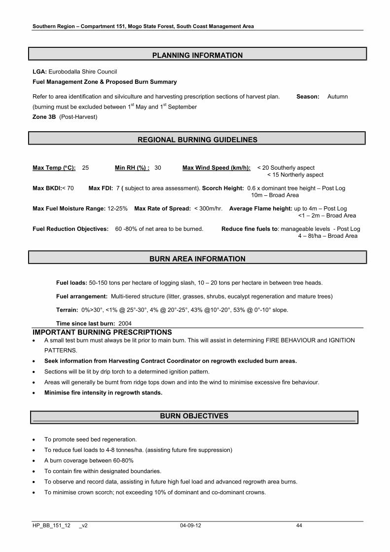
PLANNING INFORMATION
LGA: Eurobodalla Shire Council
Fuel Management Zone & Proposed Burn Summary
Refer to area identification and silviculture and harvesting prescription sections of harvest plan. Season: Autumn
(burning must be excluded between 1st May and 1st September
Zone 3B (Post-Harvest)
REGIONAL BURNING GUIDELINES
Max Temp (°C): 25 Min RH (%) : 30 Max Wind Speed (km/h): < 20 Southerly aspect < 15 Northerly aspect Max BKDI:< 70 Max FDI: 7 ( subject to area assessment). Scorch Height: 0.6 x dominant tree height – Post Log 10m – Broad Area Max Fuel Moisture Range: 12-25% Max Rate of Spread: < 300m/hr. Average Flame height: up to 4m – Post Log <1 – 2m – Broad Area Fuel Reduction Objectives: 60 -80% of net area to be burned. Reduce fine fuels to: manageable levels - Post Log 4 – 8t/ha – Broad Area
BURN AREA INFORMATION
Fuel loads: 50-150 tons per hectare of logging slash, 10 – 20 tons per hectare in between tree heads.
Fuel arrangement: Multi-tiered structure (litter, grasses, shrubs, eucalypt regeneration and mature trees)
Terrain: 0%>30°, <1% @ 25°-30°, 4% @ 20°-25°, 43% @10°-20°, 53% @ 0°-10° slope.
Time since last burn: 2004
IMPORTANT BURNING PRESCRIPTIONS • A small test burn must always be lit prior to main burn. This will assist in determining FIRE BEHAVIOUR and IGNITION
PATTERNS.
• Seek information from Harvesting Contract Coordinator on regrowth excluded burn areas.
• Sections will be lit by drip torch to a determined ignition pattern.
• Areas will generally be burnt from ridge tops down and into the wind to minimise excessive fire behaviour.
• Minimise fire intensity in regrowth stands.
BURN OBJECTIVES
• To promote seed bed regeneration.
• To reduce fuel loads to 4-8 tonnes/ha. (assisting future fire suppression)
• A burn coverage between 60-80%
• To contain fire within designated boundaries.
• To observe and record data, assisting in future high fuel load and advanced regrowth area burns.
• To minimise crown scorch; not exceeding 10% of dominant and co-dominant crowns.

Southern Region – Compartment 151, Mogo State Forest, South Coast Management Area
HP_BB_151_12 _v2 04-09-12 45
• To minimise defect damage to retained regrowth stems.
ENVIRONMENTAL PRESCRIPTIONS
FLORA AND FAUNA: Refer to Flora and Fauna sections of the Harvest plan document. H & R trees should be raked around if the risk of burning is high. Logging slash collected around retained trees should not be burnt. Note: Burning must not be carried out during the Little Lorikeet nesting period (1st of May to 1st of September). Fire must be excluded from Little Lorikeet nest exclusions during post-harvest burning. SOIL, WATER & AQUATIC HABITAT:
Refer to Soils and Water and Drainage Features sections of the Harvest plan document.
• Preferred months of burn – April to September
• Fuel moisture differentials will be utilised to minimise impacts upon drainage features within the burn area
ABORIGINAL CULTURAL HERITAGE: Refer to the cultural heritage section of the Harvest plan document. Significant sites, e.g. scar trees, groove stones, should be raked around to prevent fire damage. Where practically possible, burning of scattered artefacts should be avoided.
CONTROL AND STRATEGY
CONTROL LINES:
EXISTING Description of each control line
Description of Work Required Completed Yes /No
Lattas Point Road Nil
Mills Fishing Road Nil
Cpt 151/3 Road Nil
Check for trees that could burn down and fall over any boundary roads and wet down or rake around as necessary
PROPOSED Description of each control line
Description of Work Required Completed Yes /No
A control line is required along the entire edge of the
FMZ 2 exclusion areas to protect Batemans Marine
Park values and areas of EEC.
To be determined by Contract
Coordinator/SFO during harvesting.
A control line is required around Little Lorikeet nest
exclusion zones.
To be determined by Contract
Coordinator/SFO during harvesting.
A manually rake-hoed firebreak is
recommended to minimise disturbance.
Additional control lines may be required where snig
track network is not adequate along boundaries of NHA
(particularly along Private Property Boundaries and
utilities infrastructure).
To be determined by Contract
Coordinator/SFO during harvesting.
SMOKE HAZARD AND MANAGEMENT: http://www.bom.gov.au/general/reg/smoke/nsw/index.shtml
Smoke / Hazard Reduction Signs required?:……….. YES NO (R tick to indicate) Smoke Dispersion Forecasting via BOM utilised?..... YES NO (R tick to indicate)
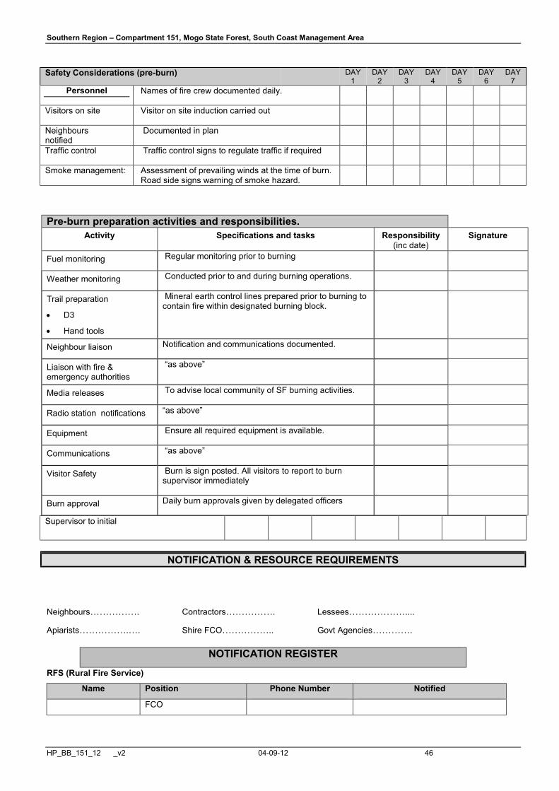
Southern Region – Compartment 151, Mogo State Forest, South Coast Management Area
HP_BB_151_12 _v2 04-09-12 46
Safety Considerations (pre-burn) DAY 1
DAY 2
DAY 3
DAY 4
DAY 5
DAY 6
DAY 7
Personnel Names of fire crew documented daily.
Visitors on site Visitor on site induction carried out
Neighbours notified
Documented in plan
Traffic control Traffic control signs to regulate traffic if required
Smoke management: Assessment of prevailing winds at the time of burn. Road side signs warning of smoke hazard.
Supervisor to initial
NOTIFICATION & RESOURCE REQUIREMENTS
Neighbours……………. Contractors……………. Lessees……………….... Apiarists…………….…. Shire FCO…………….. Govt Agencies………….
NOTIFICATION REGISTER
RFS (Rural Fire Service)
Name Position Phone Number Notified
FCO
Pre-burn preparation activities and responsibilities. Activity Specifications and tasks Responsibility
(inc date) Signature
Fuel monitoring Regular monitoring prior to burning
Weather monitoring Conducted prior to and during burning operations.
Trail preparation
• D3
• Hand tools
Mineral earth control lines prepared prior to burning to contain fire within designated burning block.
Neighbour liaison Notification and communications documented.
Liaison with fire & emergency authorities
“as above”
Media releases To advise local community of SF burning activities.
Radio station notifications “as above”
Equipment Ensure all required equipment is available.
Communications “as above”
Visitor Safety Burn is sign posted. All visitors to report to burn supervisor immediately
Burn approval Daily burn approvals given by delegated officers
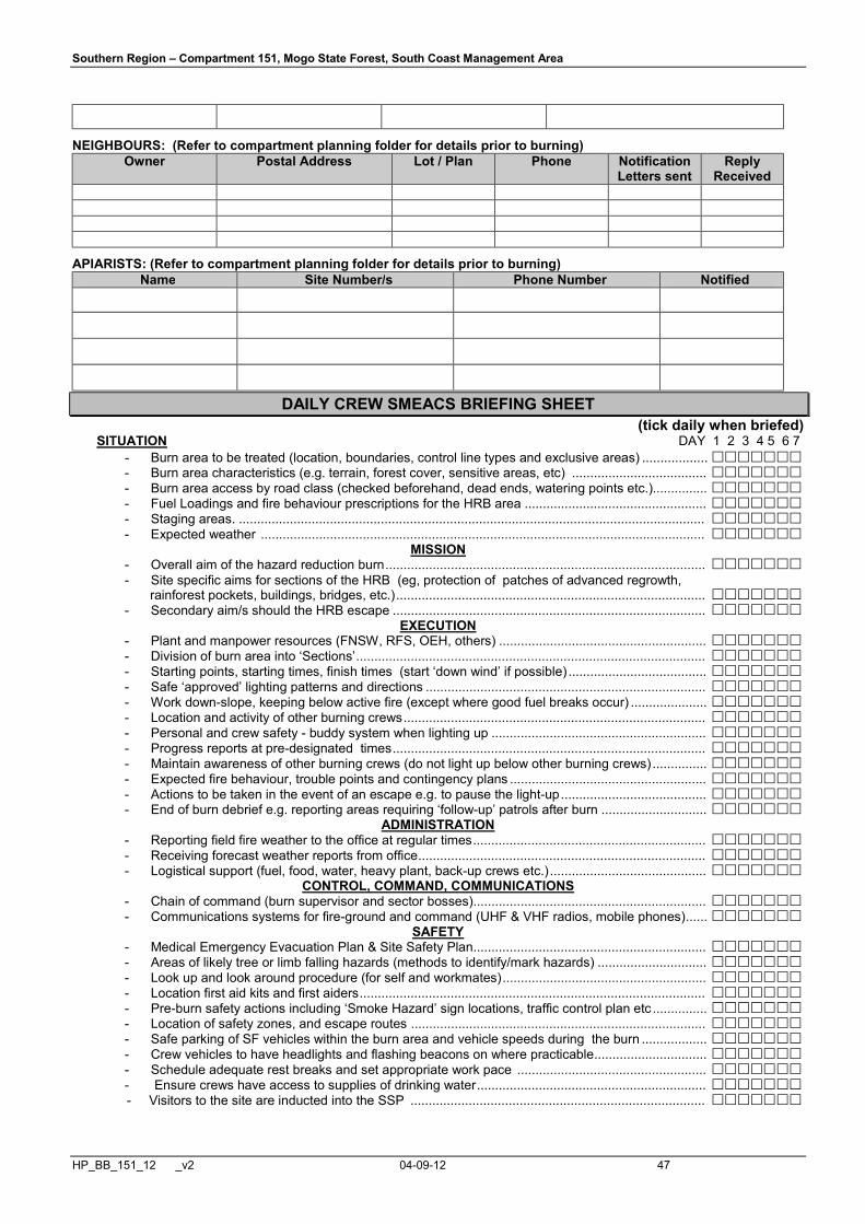
Southern Region – Compartment 151, Mogo State Forest, South Coast Management Area
HP_BB_151_12 _v2 04-09-12 47
NEIGHBOURS: (Refer to compartment planning folder for details prior to burning) Owner Postal Address Lot / Plan
Phone Notification
Letters sent Reply
Received
APIARISTS: (Refer to compartment planning folder for details prior to burning) Name Site Number/s Phone Number Notified
DAILY CREW SMEACS BRIEFING SHEET (tick daily when briefed) SITUATION DAY 1 2 3 4 5 6 7
- Burn area to be treated (location, boundaries, control line types and exclusive areas) .................. £££££££ - Burn area characteristics (e.g. terrain, forest cover, sensitive areas, etc) ..................................... £££££££ - Burn area access by road class (checked beforehand, dead ends, watering points etc.)............... £££££££ - Fuel Loadings and fire behaviour prescriptions for the HRB area .................................................. £££££££ - Staging areas. ................................................................................................................................ £££££££ - Expected weather .......................................................................................................................... £££££££
MISSION - Overall aim of the hazard reduction burn ........................................................................................ £££££££ - Site specific aims for sections of the HRB (eg, protection of patches of advanced regrowth, rainforest pockets, buildings, bridges, etc.) ..................................................................................... £££££££ - Secondary aim/s should the HRB escape ...................................................................................... £££££££
EXECUTION - Plant and manpower resources (FNSW, RFS, OEH, others) ......................................................... £££££££ - Division of burn area into ‘Sections’ ................................................................................................ £££££££ - Starting points, starting times, finish times (start ‘down wind’ if possible) ...................................... £££££££ - Safe ‘approved’ lighting patterns and directions ............................................................................. £££££££ - Work down-slope, keeping below active fire (except where good fuel breaks occur) ..................... £££££££ - Location and activity of other burning crews ................................................................................... £££££££ - Personal and crew safety - buddy system when lighting up ........................................................... £££££££ - Progress reports at pre-designated times ...................................................................................... £££££££ - Maintain awareness of other burning crews (do not light up below other burning crews) ............... £££££££ - Expected fire behaviour, trouble points and contingency plans ...................................................... £££££££ - Actions to be taken in the event of an escape e.g. to pause the light-up ........................................ £££££££ - End of burn debrief e.g. reporting areas requiring ‘follow-up’ patrols after burn ............................. £££££££
ADMINISTRATION - Reporting field fire weather to the office at regular times ................................................................ £££££££ - Receiving forecast weather reports from office ............................................................................... £££££££ - Logistical support (fuel, food, water, heavy plant, back-up crews etc.) ........................................... £££££££
CONTROL, COMMAND, COMMUNICATIONS - Chain of command (burn supervisor and sector bosses) ................................................................ £££££££ - Communications systems for fire-ground and command (UHF & VHF radios, mobile phones) ...... £££££££
SAFETY - Medical Emergency Evacuation Plan & Site Safety Plan ................................................................ £££££££ - Areas of likely tree or limb falling hazards (methods to identify/mark hazards) .............................. £££££££ - Look up and look around procedure (for self and workmates) ........................................................ £££££££ - Location first aid kits and first aiders ............................................................................................... £££££££ - Pre-burn safety actions including ‘Smoke Hazard’ sign locations, traffic control plan etc ............... £££££££ - Location of safety zones, and escape routes ................................................................................. £££££££ - Safe parking of SF vehicles within the burn area and vehicle speeds during the burn .................. £££££££ - Crew vehicles to have headlights and flashing beacons on where practicable ............................... £££££££ - Schedule adequate rest breaks and set appropriate work pace .................................................... £££££££ - Ensure crews have access to supplies of drinking water ............................................................... £££££££
- Visitors to the site are inducted into the SSP ................................................................................. £££££££

Southern Region – Compartment 151, Mogo State Forest, South Coast Management Area
HP_BB_151_12 _v2 04-09-12 48
Day 1 - Burn Supervisor………………………Date………….. Day 2 - Burn Supervisor…………………………Date………….. Day 3 - Burn Supervisor………………………Date………….. Day 4 - Burn Supervisor…………………………Date………….. Day 5 - Burn Supervisor………………………Date………….. Day 6 - Burn Supervisor…………………………Date………….. Day 7 - Burn Supervisor………………………Date………….. Day 8 - Burn Supervisor…………………………Date…………..
EMPLOYEE IDENTIFICATION
EMPLOYEE
NAME
PROOF OF ACCREDITATION
(E.g. FNSW RECORDS)
DATE SUPERVISOR OR RELEVANT AGENCY
SIGNATURE Incident Controller
Burn Supervisor
Crew Leader
Crew Leader
Crew Member
Crew Member
Crew Member
Crew Member
Crew Member
Crew Member
Crew Member
Crew Member
Personnel and equipment requirements: Resource State Forests NPWS Brigades Contract Coordinator
Signature
Incident Controller
Crew Leaders
Crew Members
Tankers 1
Slip – on Units 1+
Dozer n/a
Helicopter n/a
Radios – handheld UHF 1 per person
Weather monitoring equip. 1 per crew
Burning Operations Record
Forecast Weather and Indices (Obtain from Office)
See attached daily weather forecasts and relevant indices obtained from the Bureau of Meteorology
Burn Site Weather Readings Take daily on site readings (hourly if possible) and note un-forecast weather changes.
Date
Time
Temp
(°C)
RH
(%)
Wind
Direction
Wind Sp.
(km/h)
FDI FMC %
COMMENTS
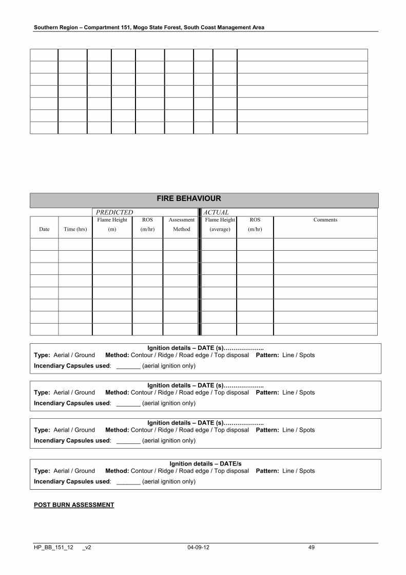
Southern Region – Compartment 151, Mogo State Forest, South Coast Management Area
HP_BB_151_12 _v2 04-09-12 49
FIRE BEHAVIOUR
PREDICTED ACTUAL
Date
Time (hrs)
Flame Height
(m)
ROS
(m/hr)
Assessment
Method
Flame Height
(average)
ROS
(m/hr)
Comments
Ignition details – DATE (s)………………..
Type: Aerial / Ground Method: Contour / Ridge / Road edge / Top disposal Pattern: Line / Spots
Incendiary Capsules used: _______ (aerial ignition only)
Ignition details – DATE (s)………………..
Type: Aerial / Ground Method: Contour / Ridge / Road edge / Top disposal Pattern: Line / Spots
Incendiary Capsules used: _______ (aerial ignition only)
Ignition details – DATE (s)………………..
Type: Aerial / Ground Method: Contour / Ridge / Road edge / Top disposal Pattern: Line / Spots
Incendiary Capsules used: _______ (aerial ignition only)
Ignition details – DATE/s Type: Aerial / Ground Method: Contour / Ridge / Road edge / Top disposal Pattern: Line / Spots
Incendiary Capsules used: _______ (aerial ignition only)
POST BURN ASSESSMENT

Southern Region – Compartment 151, Mogo State Forest, South Coast Management Area
HP_BB_151_12 _v2 04-09-12 50
Estimated burn coverage (% of net area):…………………..%
Estimated burn coverage:…………………………………….ha
Fine fuel reduced to an average of :………………………….t/ha Estimated area of crown scorch :……………………………. %
OPERATIONAL PERFORMANCE REVIEW Burn complete? Yes/No Follow up action required ? Yes/No Burn contained within planned boundaries? Yes/No Burn coverage objective met? Yes/No
Fine fuel reduction objective met? Yes/No Environmental prescriptions met? Yes/No Threatened Species License conditions met? Yes/No Fisheries License conditions met? Yes/No Remedial Action required (if any):_______________________________________________________________________ ____________________________________________________________________________________________________________________________________________________________________________________________________________________________________________________________________________________________________________
Remedial works certified complete. Work Supervisor___________________________________________________________ Date:_______________
Comments:__________________________________________________________________________________________________________________________________________________________________________________________________________________________________________________________________________________________________________________________________________________________________________________________________________________________________________________________________________________________________________________________________________________________________________________________________________________________________________________________________________________________________________________
Attach additional pages as required