Lockheed SAR
12
History of SAR at Lockheed Martin (formerly Goodyear Aerospace) Stephen W. Lasswell Lockheed Martin Corporation, 1300 South Litchfield Road, Goodyear, AZ USA 85338 ABSTRACT Synthetic Aperture Radar (SAR) was invented by Carl Wiley at Goodyear Aircraft Company in Goodyear, Arizona, in 1951. From that time forward, as the company became Goodyear Aerospace Corporation, Loral Corporation, and finally Lockheed Martin Corporation, the Arizona employees past and present played a long and storied role in numerous SAR firsts. These include the original SAR patent (known as Simultaneous Doppler Buildup), the first demonstration SAR and flight test, the first operational SAR system, the first operational SAR data link, the first 5-foot resolution operational SAR system, the first 1-foot resolution SAR system, and the first large scale SAR digital processor. The company has installed and flown over five hundred SAR systems on more than thirty different types of aircraft for numerous countries throughout the world. The company designed and produced all of the evolving high performance SAR systems for the U. S. Air Force SR-71 “Blackbird” spy plane throughout its entire operational history, spanning some twenty-nine years. Recent SAR accomplishments include long-range standoff high performance SAR systems, smaller high resolution podded SAR systems for fighter aircraft, and foliage penetration (FOPEN) SAR. The company is currently developing the high performance SAR/MTI (Moving Target Indication) radar for the Army Aerial Common Sensor (ACS) system. Keywords: Synthetic Aperture Radar, SAR, SAR patent, SAR history 1. INTRODUCTION Every great idea grows from the seed of past invention. One excellent example of this is Synthetic Aperture Radar, or SAR. In fact, SAR technology continues to evolve rapidly, and we can still expect exciting new SAR applications and advancements in the future. It’s an interesting exercise – even quite fun – to trace the history of SAR. The invention of SAR is the story of an eccentric genius who led a crazy team of scientists, engineers and mathematicians. And looking back at the past in this way can inspire us to realize the potential of SAR’s future. Lockheed Martin (with its legacy companies Goodyear and Loral) is proud to have had a long and pivotal role in numerous SAR firsts, including holding the original patent. We’ve employed some brilliant minds who worked together tirelessly to create, test, and eventually apply the original models of many of the radar devices used today. Although this paper focuses on Lockheed Martin and its legacy companies, we certainly recognize and applaud the fact that several other organizations also performed important and necessary work in the development of SAR technology. 2. SAR HISTORY But getting back to the history of SAR, let’s get started way back in 1904. Few of you might realize that radar has been around over one hundred years. In 1904, the “Telemobilescope” was created. This device could detect remote metallic objects (like ships) in the darkness, fog, and rain, and in doing so could prevent terrible ship disasters. Its purpose was to ring a bell whenever a ship passed under a test bridge and a nearby receiver picked up the radar echo signals. Keynote Address Radar Sensor Technology IX, edited by Robert N. Trebits, James L. Kurtz, Proceedings of SPIE Vol. 5788 (SPIE, Bellingham, WA, 2005) 0277-786X/05/$15 · doi: 10.1117/12.603927 1 Downloaded From: http://proceedings.spiedigitallibrary.org/ on 04/24/2015 Terms of Use: http://spiedl.org/terms
-
Upload
bring-it-on -
Category
Documents
-
view
75 -
download
5
description
Lockheed SAR
Transcript of Lockheed SAR

History of SAR at Lockheed Martin (formerly Goodyear Aerospace)
Stephen W. Lasswell Lockheed Martin Corporation, 1300 South Litchfield Road, Goodyear, AZ USA 85338
ABSTRACT
Synthetic Aperture Radar (SAR) was invented by Carl Wiley at Goodyear Aircraft Company in Goodyear, Arizona, in 1951. From that time forward, as the company became Goodyear Aerospace Corporation, Loral Corporation, and finally Lockheed Martin Corporation, the Arizona employees past and present played a long and storied role in numerous SAR firsts. These include the original SAR patent (known as Simultaneous Doppler Buildup), the first demonstration SAR and flight test, the first operational SAR system, the first operational SAR data link, the first 5-foot resolution operational SAR system, the first 1-foot resolution SAR system, and the first large scale SAR digital processor. The company has installed and flown over five hundred SAR systems on more than thirty different types of aircraft for numerous countries throughout the world. The company designed and produced all of the evolving high performance SAR systems for the U. S. Air Force SR-71 “Blackbird” spy plane throughout its entire operational history, spanning some twenty-nine years. Recent SAR accomplishments include long-range standoff high performance SAR systems, smaller high resolution podded SAR systems for fighter aircraft, and foliage penetration (FOPEN) SAR. The company is currently developing the high performance SAR/MTI (Moving Target Indication) radar for the Army Aerial Common Sensor (ACS) system. Keywords: Synthetic Aperture Radar, SAR, SAR patent, SAR history
1. INTRODUCTION
Every great idea grows from the seed of past invention. One excellent example of this is Synthetic Aperture Radar, or SAR. In fact, SAR technology continues to evolve rapidly, and we can still expect exciting new SAR applications and advancements in the future. It’s an interesting exercise – even quite fun – to trace the history of SAR. The invention of SAR is the story of an eccentric genius who led a crazy team of scientists, engineers and mathematicians. And looking back at the past in this way can inspire us to realize the potential of SAR’s future. Lockheed Martin (with its legacy companies Goodyear and Loral) is proud to have had a long and pivotal role in numerous SAR firsts, including holding the original patent. We’ve employed some brilliant minds who worked together tirelessly to create, test, and eventually apply the original models of many of the radar devices used today. Although this paper focuses on Lockheed Martin and its legacy companies, we certainly recognize and applaud the fact that several other organizations also performed important and necessary work in the development of SAR technology.
2. SAR HISTORY But getting back to the history of SAR, let’s get started way back in 1904. Few of you might realize that radar has been around over one hundred years. In 1904, the “Telemobilescope” was created. This device could detect remote metallic objects (like ships) in the darkness, fog, and rain, and in doing so could prevent terrible ship disasters. Its purpose was to ring a bell whenever a ship passed under a test bridge and a nearby receiver picked up the radar echo signals.
Keynote Address
Radar Sensor Technology IX, edited by Robert N. Trebits, James L. Kurtz,Proceedings of SPIE Vol. 5788 (SPIE, Bellingham, WA, 2005)0277-786X/05/$15 · doi: 10.1117/12.603927
1
Downloaded From: http://proceedings.spiedigitallibrary.org/ on 04/24/2015 Terms of Use: http://spiedl.org/terms

This was the birth of radar. By World War II, radar had come into its own and was really the “IT” tool, primarily for defense against incoming aircraft and missiles. With the importance and credibility of radar well established, the invention of SAR followed. 2.1 Carl Wiley and the 1950s So the story of SAR begins in 1951 with a genius engineer named Carl A. Wiley (Figure 1). Carl was, to put it mildly, a character. In the 1940s, he had been the first U.S. scientist to discuss the design of space sails, orbits for sail-craft, and the advantages of solar sailing for travel between planets. He was confident, but aware of his critics as well. In fact, Wiley was so concerned about his peers’ opinions of his scientific theories that he published his work under a pseudonym, Russell Sanders. Carl Wiley came to Goodyear Aircraft Company in 1950 to begin a new scientific project. He had come to the realization that if radar pulses were coherent, you could process the pulses and create two-dimensional imagery with greatly improved resolution. Wiley’s breakthrough observation of the Doppler effect was the birth of what he called Simultaneous Buildup Doppler. He was issued a patent that is generally recognized as the SAR patent (Figure 2). His invention was driven by the need to guide the 1950s version of a cruise missile (the MACE) to its destination using onboard radar (called ATRAN, or Automatic Terrain Recognition & Navigation) to provide day/night, all-weather guidance. He received a patent for this. The first radar to make an image using the SAR principle was a Goodyear system called DOUSER. It flew on a C-47 and made its first image in 1955 with resolution on the order of 500 feet (Figure 3). Figure 1 – Carl A. Wiley, the inventor of SAR radar. Figure 2 – The patent for SAR radar. Figure 3 – The first Douser images using the SAR principle. Carl Wiley came up with new ideas every morning. Fellow engineers that knew him best say that he enjoyed driving almost everyone at Goodyear crazy, including potential clients. But the Purchasing Operations Department was Wiley’s favorite target. They were very particular about spending, and they scrutinized every purchasing request that Wiley and his fellow engineers would submit. Imagine that! Wiley once submitted a request to purchase a fishing rod for a lab experiment involving the use of a tank of liquid to simulate SAR propagation phenomena. The request was quickly denied. He re-submitted the request providing more
2 Proc. of SPIE Vol. 5788
Downloaded From: http://proceedings.spiedigitallibrary.org/ on 04/24/2015 Terms of Use: http://spiedl.org/terms

detail as to why he needed a fishing rod to further his research. It was denied again. Purchasing did not believe that Wiley was going to use a fishing rod for research. Wiley thought about it, consulted some of the other engineers in his group, and then, as all great minds do, changed his tactic in order to get what he wanted. He submitted a new form, only this time he requested funds for purchasing a “Pescatorial Extractor.” Purchasing Operations approved his request immediately with no questions asked. It just goes to show you that great scientific minds tend to do their best work “outside the box.” In 1952, Wiley moved his lab from the Goodyear Aircraft Company headquarters in Akron, Ohio, to Arizona. Why Arizona? Surprisingly, it came down to cotton, tires, and the Middle East. Goodyear Tire & Rubber Company needed long staple cotton to manufacture tire cord (these were the days before synthetic fibers had been invented). Until this point, Goodyear had relied on other areas of the world for the appropriate cotton, but the world was becoming a different place and Goodyear became concerned that their supply might be cut off if there were any political unrest or another major war. Arizona’s climate conditions were perfect to grow the long staple cotton that Goodyear needed for their tires. They made the decision to purchase a large amount of “land in the middle of nowhere” that was suitable for growing this cotton. No place was more in the “middle of nowhere” than the land they chose west of Phoenix, Arizona, in the early 1900s. World War II arrived and the Navy decided that they needed a Naval Air Center that was not on the coast and therefore less vulnerable to enemy attack. They thought Goodyear was on to something with their move to Arizona. The Navy purchased land in Arizona and contracted Goodyear, a known and experienced manufacturing company, to construct their Naval facility west of Phoenix. Goodyear remanufactured Naval aircraft in these facilities during the war.
But after the war, the Navy no longer had the need for a base in Arizona. They offered to sell their base to Goodyear, who then became the proud owner of a serious amount of large, well-built, but empty buildings “in the middle of nowhere.” Big ideas filled those big empty spaces once Carl Wiley moved his radar lab from Ohio to Arizona. Goodyear had the easy task of convincing a small group of talented engineers, physicists, and mathematicians to join Wiley on what would turn out to be the adventure of their lifetime. With Wiley on board, it wasn’t difficult to get the others to Arizona as well. This group of motivated engineers worked together, nearly around the clock, for months and years on new ways to implement and test Wiley’s Simultaneous Buildup Doppler. Wiley’s team built Missile Guidance systems and other test beds in determined attempts to catch the interest of customers and prove SAR’s worth. One pioneer, Don Beckerleg, described what it was like as an outsider coming into Wiley’s laboratory just as the team was assembled to examine some of the gathered radar images. “They were all jumping up and down, but the mountains, shadows, and rivers all looked like grey blobs to me.” Those on Wiley’s team in 1951 could not yet see Wiley’s vision of SAR, and were not all in perfect stride alongside him. But the team’s roller coaster ride of discovery was just beginning. A clear vision and an active imagination, mixed with solid teamwork, were giving this team their mark in scientific history. Through the coming years, Wiley’s techniques would be applied to steadily improve SAR image resolution, moving SAR toward the indispensable sensor it is today (Figure 4).
Proc. of SPIE Vol. 5788 3
Downloaded From: http://proceedings.spiedigitallibrary.org/ on 04/24/2015 Terms of Use: http://spiedl.org/terms

Figure 4 – SAR Resolution Chart. Wiley left Goodyear in 1953 to launch his own company, returning the following year as a consultant. He soon passed the baton to his very capable team and his genius moved on to other things. The Goodyear engineering team went on to develop two significant SAR systems that flew in the late fifties, both designated AN/APS-73. The first was called XH-1 and it flew on a B-29 aircraft with more than 100-foot resolution. The second was called, sensibly enough, XH-2, and it flew on a C-97 with more than 50-foot resolution. 2.2 The 1960s Just prior to 1960, at the encouragement of the United States government, Goodyear began a program called “Quick Check,” also designated AN/APS-73 and known as XH-3. This program ended up opening up huge opportunities for SAR. Before signing on as believers in SAR, the government told Goodyear they needed concrete proof that live radar images could be displayed on an aircraft so that pilots flying the aircraft could establish their location at all times. Obviously, this would be an enormous advancement. Quick Check, which flew on the B-58 (Figure 5), demonstrated that live radar images could indeed be displayed inflight. This created an amazing amount of excitement for the future technology of all airplanes, and specifically checked the final square necessary to begin the development of the supersonic spy plane, the SR-71 “Blackbird.” Goodyear’s next SAR development in the AN/APS-73 series was the XH-4 SAR, also known as 665A, a totally unclassified effort with approximately 50-foot resolution. This effort, together with their performance on the B-58, was a key factor that led to Goodyear’s selection in a tough fought competition to build the first imaging radar for the SR-71, a very secret special access program with resolution on the order of 30 feet. Figure 5 – B-58 with SAR components. Goodyear also supplied an electronic (but certainly not digital) in-flight image processor for the navigation imaging radar on the supersonic B-70, which turned out to be a predecessor for the Mach 3+ SR-71. Legend has it that the B-70
4 Proc. of SPIE Vol. 5788
Downloaded From: http://proceedings.spiedigitallibrary.org/ on 04/24/2015 Terms of Use: http://spiedl.org/terms

was nicknamed “the Savior” when visitors viewing the enormous streamlined aircraft for the first time would exclaim, “Jesus Christ!” It was a strange looking and very exotic bird. It’s now featured for everyone to see at the Air Force museum at Wright Patterson Air Force Base in Dayton, Ohio. The Goodyear B-70 processor was flight tested on a C-97 with the XH-2 radar system. The SR-71 “Blackbird” was given the go ahead in 1960 and took four years to build. In December of 1964, the SR-71 was flying with a Goodyear SAR called KP1. It had resolution of about 30 feet and a maximum range of 100 nmi, which was a great accomplishment given the flight regime of the Blackbird. The government had asked for a plane that flew over three times the speed of sound at altitudes above 80,000 feet. They wanted the SR-71 to fly over borders and denied areas without being shot down. They asked for it, and we gave it to them. The SR-71 was often used in operations in which it would fly along enemy borders, or even overfly denied areas. The aircraft would come up on enemy radar, but no one would have the ability to reach it. This was meant to intimidate the enemy–let them know that the U.S. could collect intelligence with impunity. And how could they perform these maneuvers safely and confidently? Because of the SAR system onboard the plane that allowed the pilots to know precisely where they were at all times, even if the SR-71 inertial navigation system (INS) should lose accuracy or even fail. The SR-71 project was one of the longest running SAR programs of all time, lasting an impressive twenty-nine years with continually improving performance. In the early 1960s, the U. S. Air Force began large scale production of the reconnaissance version of the world’s premier fighter aircraft. It was known as the RF-4C (Figure 6), and half of the RF-4Cs were outfitted with a production Goodyear SAR, called the AN/APQ-102A. Its best resolution was about 30 feet, which still left much to be desired in terms of true operational utility.
The AN/UPD-3 SAR, known as XE-1, was an advanced design that Goodyear developed for the Air Force starting in the 1960s. It flew in the early 1970s on a KC-135 and achieved 5-foot resolution. In order to record the raw data from this radar onboard the aircraft, the Goodyear engineers developed the world’s first high resolution laser beam film recorder. This was just another example of SAR necessity being the “mother of invention” in related technologies. When the SAR pioneers needed technology that hadn’t been invented yet, they invented it. Time after time, the imaginative spirit of Carl Wiley seemed to shine yet again. Figure 6 – RF-4C with SAR components.
Two other Goodyear SARs from the 1960s are worthy of note. The Polyfrequency SAR was a research radar that had record-breaking bandwidth of 8 GHz. It flew on a C-131 and generated the world’s first 1-foot resolution SAR imagery (which, believe it or not, is still classified to this day). The other new SAR of the 1960s was called FOPEN A-1. It flew on a KC-135 and operated in a low frequency band (UHF) that enabled it to penetrate tree foliage (leaves and branches). It could indeed see through the trees, but SAR processing was not yet sophisticated enough for it to tell the difference between vehicles hiding under the trees and the tree trunks themselves, which have a significant radar return at UHF band.
Proc. of SPIE Vol. 5788 5
Downloaded From: http://proceedings.spiedigitallibrary.org/ on 04/24/2015 Terms of Use: http://spiedl.org/terms
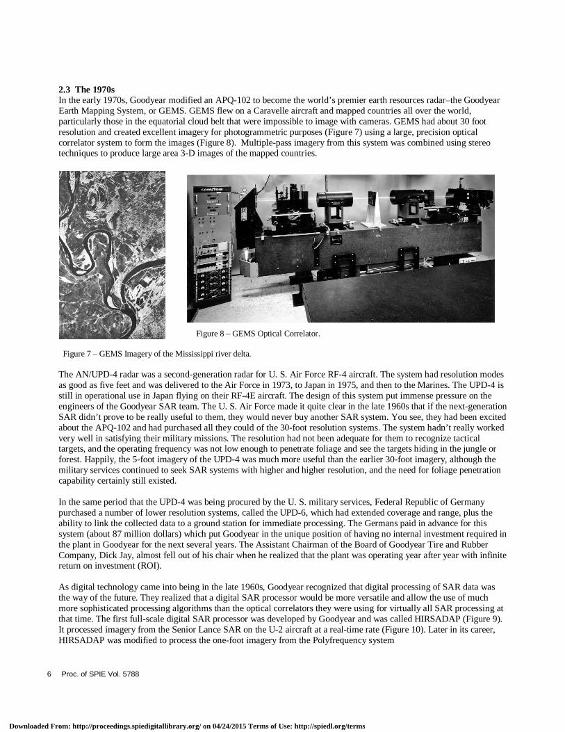
2.3 The 1970s In the early 1970s, Goodyear modified an APQ-102 to become the world’s premier earth resources radar–the Goodyear Earth Mapping System, or GEMS. GEMS flew on a Caravelle aircraft and mapped countries all over the world, particularly those in the equatorial cloud belt that were impossible to image with cameras. GEMS had about 30 foot resolution and created excellent imagery for photogrammetric purposes (Figure 7) using a large, precision optical correlator system to form the images (Figure 8). Multiple-pass imagery from this system was combined using stereo techniques to produce large area 3-D images of the mapped countries. Figure 8 – GEMS Optical Correlator. Figure 7 – GEMS Imagery of the Mississippi river delta. The AN/UPD-4 radar was a second-generation radar for U. S. Air Force RF-4 aircraft. The system had resolution modes as good as five feet and was delivered to the Air Force in 1973, to Japan in 1975, and then to the Marines. The UPD-4 is still in operational use in Japan flying on their RF-4E aircraft. The design of this system put immense pressure on the engineers of the Goodyear SAR team. The U. S. Air Force made it quite clear in the late 1960s that if the next-generation SAR didn’t prove to be really useful to them, they would never buy another SAR system. You see, they had been excited about the APQ-102 and had purchased all they could of the 30-foot resolution systems. The system hadn’t really worked very well in satisfying their military missions. The resolution had not been adequate for them to recognize tactical targets, and the operating frequency was not low enough to penetrate foliage and see the targets hiding in the jungle or forest. Happily, the 5-foot imagery of the UPD-4 was much more useful than the earlier 30-foot imagery, although the military services continued to seek SAR systems with higher and higher resolution, and the need for foliage penetration capability certainly still existed. In the same period that the UPD-4 was being procured by the U. S. military services, Federal Republic of Germany purchased a number of lower resolution systems, called the UPD-6, which had extended coverage and range, plus the ability to link the collected data to a ground station for immediate processing. The Germans paid in advance for this system (about 87 million dollars) which put Goodyear in the unique position of having no internal investment required in the plant in Goodyear for the next several years. The Assistant Chairman of the Board of Goodyear Tire and Rubber Company, Dick Jay, almost fell out of his chair when he realized that the plant was operating year after year with infinite return on investment (ROI). As digital technology came into being in the late 1960s, Goodyear recognized that digital processing of SAR data was the way of the future. They realized that a digital SAR processor would be more versatile and allow the use of much more sophisticated processing algorithms than the optical correlators they were using for virtually all SAR processing at that time. The first full-scale digital SAR processor was developed by Goodyear and was called HIRSADAP (Figure 9). It processed imagery from the Senior Lance SAR on the U-2 aircraft at a real-time rate (Figure 10). Later in its career, HIRSADAP was modified to process the one-foot imagery from the Polyfrequency system
6 Proc. of SPIE Vol. 5788
Downloaded From: http://proceedings.spiedigitallibrary.org/ on 04/24/2015 Terms of Use: http://spiedl.org/terms

Figure 9 – HIRSADAP Real Time Digital SAR Processing System.
Figure 10 – HIRSADAP Imagery. Then, in 1974, Goodyear won a significant Air Force digital processor competition called the Synthetic Aperture Precision Processor High Resolution program (SAPPHIRE). The SAPPHIRE processor (Figure 11) was designed as a full-throughput processor for the UPD-4 radar. It could process a 10-mile wide imagery swath at 5-foot resolution with excellent image quality (Figure 12) with an aircraft speed beyond Mach 1. Figure 11 – SAPPHIRE Real Time Digital SAR Processing System. Figure 12 – SAPPHIRE Imagery. The early 1970s also saw the upgrade of the SAR on the SR-71 Blackbird. The earlier 30-foot resolution system was replaced with a 5-foot resolution SAR known as the Capability Reconnaissance system (CAPRE). Then, after CAPRE became operational, Goodyear was funded to develop a prototype 1-foot resolution SAR for the Blackbird. It was called the Optic Bar Radar (OBR) in deference to the very successful Optic Bar Camera that was flying on the aircraft at that time. Computers have had a similar evolution as SAR and even today continue to become more advanced year after year. At one point in the mid-1970s on the SR-71 program, Goodyear bought the latest and greatest mini-computer, disk storage system, and digital display system for a state-of-the-art SAR digital processing laboratory. RAM memory was not
Proc. of SPIE Vol. 5788 7
Downloaded From: http://proceedings.spiedigitallibrary.org/ on 04/24/2015 Terms of Use: http://spiedl.org/terms

available yet, so the computer filled the top of a desk and had an amazing 32 kilobytes of magnetic core memory. Its 78-megabyte disk system was the size of a side-by-side refrigerator. The system was used to develop the first digital implementation of the SAR polar processing algorithm. This advanced algorithm, which had been conceived and implemented optically at the Environmental Research Institute of Michigan (ERIM), enabled the jump from 5-foot resolution to 1-foot. It’s interesting to note now that this historic minicomputer would be blown away by today’s PDA technology. Also during the 1970s, Goodyear built a series of ever-improving prototype SAR systems for the U-2 aircraft (Figure 13). These systems ranged from 5-foot resolution (Figure 14) to the first long-range 1-foot SAR (known as Lance Delta). Although the SAR engineers and scientists certainly had their setbacks as they pushed SAR technology to higher and higher performance, they had a whole lot of fun, too. For instance, Goodyear conducted an experiment in the 1970s with one of the U-2 radars where the customer was curious as to what would happen if you pointed the radar straight down. Operating in this geometry, the range dimension becomes elevation, so if you image mountains, the imagery really looks like three dimensional mountains. However, the images from left and right of the flightpath overlay each other because there is no way to differentiate between the two sides, and the images merge. Figure 13 – U-2 Lance Delta. Figure 14 – U-2 Senior Lance Bay Bridge Image So when the U-2 imaged various areas throughout Arizona looking straight down, the resulting imagery looked very much like the Lunar Sounder imagery–a device that flew around the moon and did vertical mapping of the moon’s surface with Goodyear involvement in the processing. These U-2 images ended up in the back room of the SR-71 project area, hanging on the wall. As it happened, there was one image of a little Arizona desert city that overlaid into a fold of some of the mountains. The Goodyear folks would call people in to this little room and let them have a look at the imagery. They would then tell them that they were the Lunar Sounder images and that they had found a city on the moon. The visitors would be stunned–absolutely amazed. Of course, they probably went away thinking the Goodyear engineers were “lunar-tics.” Another amazing SAR system that Goodyear built in the early 1970s was a topographic SAR, called the AN/APQ-152 Topographic Mapping System, or TOPO. This radar flew on a C-130 and used vertically offset antennas to produce three-dimensional SAR imagery, with topographic elevation lines automatically produced in the imagery. These elevation lines were caused by intentional destructive interference between the images from the two antennas. It was an amazing pre-digital system that implemented interferometric SAR principles with optical processing.
8 Proc. of SPIE Vol. 5788
Downloaded From: http://proceedings.spiedigitallibrary.org/ on 04/24/2015 Terms of Use: http://spiedl.org/terms

2.4 The 1980s & 1990s In 1980, Goodyear won the Air Force competition to put a production 1-foot radar system, known as ASARS-1, on the SR-71 (Figure 15). This system worked very well and ended up being the final operational SAR on the SR-71 before its ultimate retirement in the mid 1990s. Figure 15 – A picture of SR-71 and ASARS-1 Equipment. But this Mach 3+ aircraft with its high resolution SAR needed onboard digital tape recording with extremely high recording rate. During the development period of ASARS-1, no such airborne tape recorder existed. The Goodyear team went out and purchased a commercial airborne tape transport. They purchased high performance recording heads from a second company, and then built their own digital input and output electronics, creating the first high rate airborne digital tape recorder. They had accomplished what commercial industry wasn’t going to do for another five years; but due to program security, they couldn’t tell the tape companies what they had done. In the early 1980s, Goodyear developed the first successful bistatic SAR system in a research and development program for the Air Force. The program produced good 10-foot resolution imagery with the radar transmitter in one aircraft and the receiver in a completely separate aircraft. In the late 1980s, Loral (having purchased Goodyear Aerospace) won a competition to build a 1-foot resolution, multi-polarization, Ka-band SAR system for MIT Lincoln Labs to fly on their Gulfstream I. It was called the Advanced Detection Technology System, or ADTS, and it created the first unclassified 1-foot resolution imagery (Figure 16). Figure 16 – ADTS Image.
Proc. of SPIE Vol. 5788 9
Downloaded From: http://proceedings.spiedigitallibrary.org/ on 04/24/2015 Terms of Use: http://spiedl.org/terms
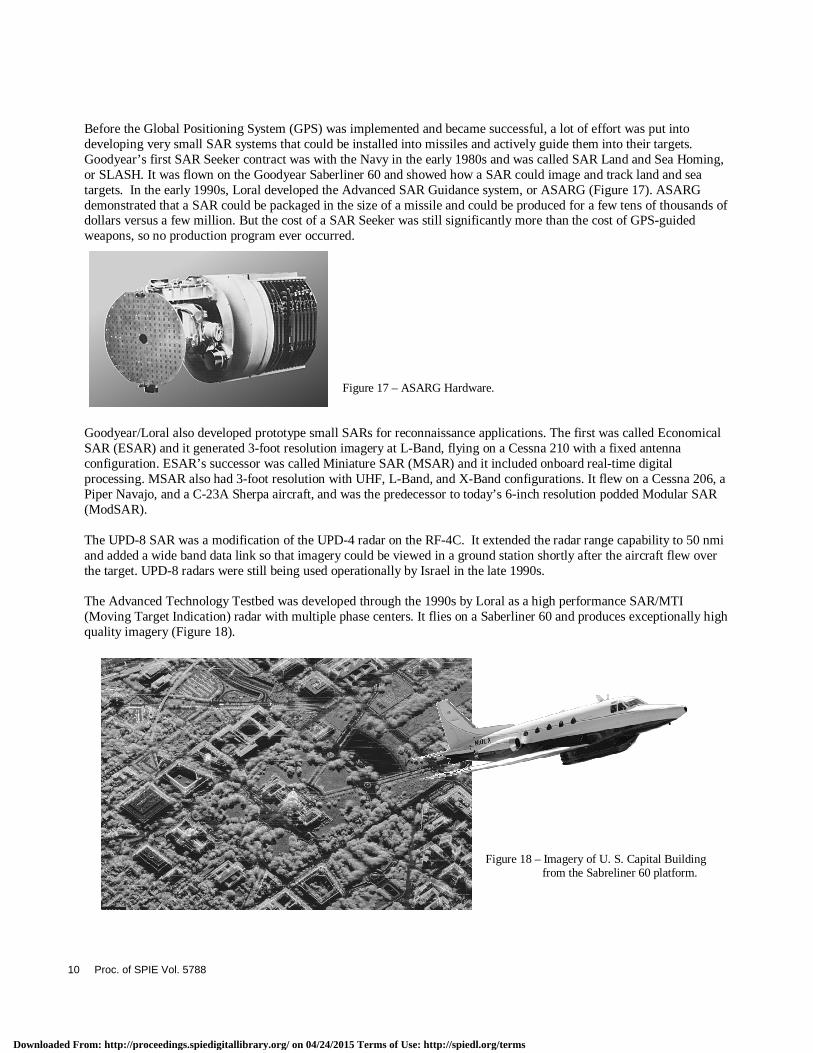
Before the Global Positioning System (GPS) was implemented and became successful, a lot of effort was put into developing very small SAR systems that could be installed into missiles and actively guide them into their targets. Goodyear’s first SAR Seeker contract was with the Navy in the early 1980s and was called SAR Land and Sea Homing, or SLASH. It was flown on the Goodyear Saberliner 60 and showed how a SAR could image and track land and sea targets. In the early 1990s, Loral developed the Advanced SAR Guidance system, or ASARG (Figure 17). ASARG demonstrated that a SAR could be packaged in the size of a missile and could be produced for a few tens of thousands of dollars versus a few million. But the cost of a SAR Seeker was still significantly more than the cost of GPS-guided weapons, so no production program ever occurred. Figure 17 – ASARG Hardware. Goodyear/Loral also developed prototype small SARs for reconnaissance applications. The first was called Economical SAR (ESAR) and it generated 3-foot resolution imagery at L-Band, flying on a Cessna 210 with a fixed antenna configuration. ESAR’s successor was called Miniature SAR (MSAR) and it included onboard real-time digital processing. MSAR also had 3-foot resolution with UHF, L-Band, and X-Band configurations. It flew on a Cessna 206, a Piper Navajo, and a C-23A Sherpa aircraft, and was the predecessor to today’s 6-inch resolution podded Modular SAR (ModSAR). The UPD-8 SAR was a modification of the UPD-4 radar on the RF-4C. It extended the radar range capability to 50 nmi and added a wide band data link so that imagery could be viewed in a ground station shortly after the aircraft flew over the target. UPD-8 radars were still being used operationally by Israel in the late 1990s. The Advanced Technology Testbed was developed through the 1990s by Loral as a high performance SAR/MTI (Moving Target Indication) radar with multiple phase centers. It flies on a Saberliner 60 and produces exceptionally high quality imagery (Figure 18). Figure 18 – Imagery of U. S. Capital Building from the Sabreliner 60 platform.
10 Proc. of SPIE Vol. 5788
Downloaded From: http://proceedings.spiedigitallibrary.org/ on 04/24/2015 Terms of Use: http://spiedl.org/terms
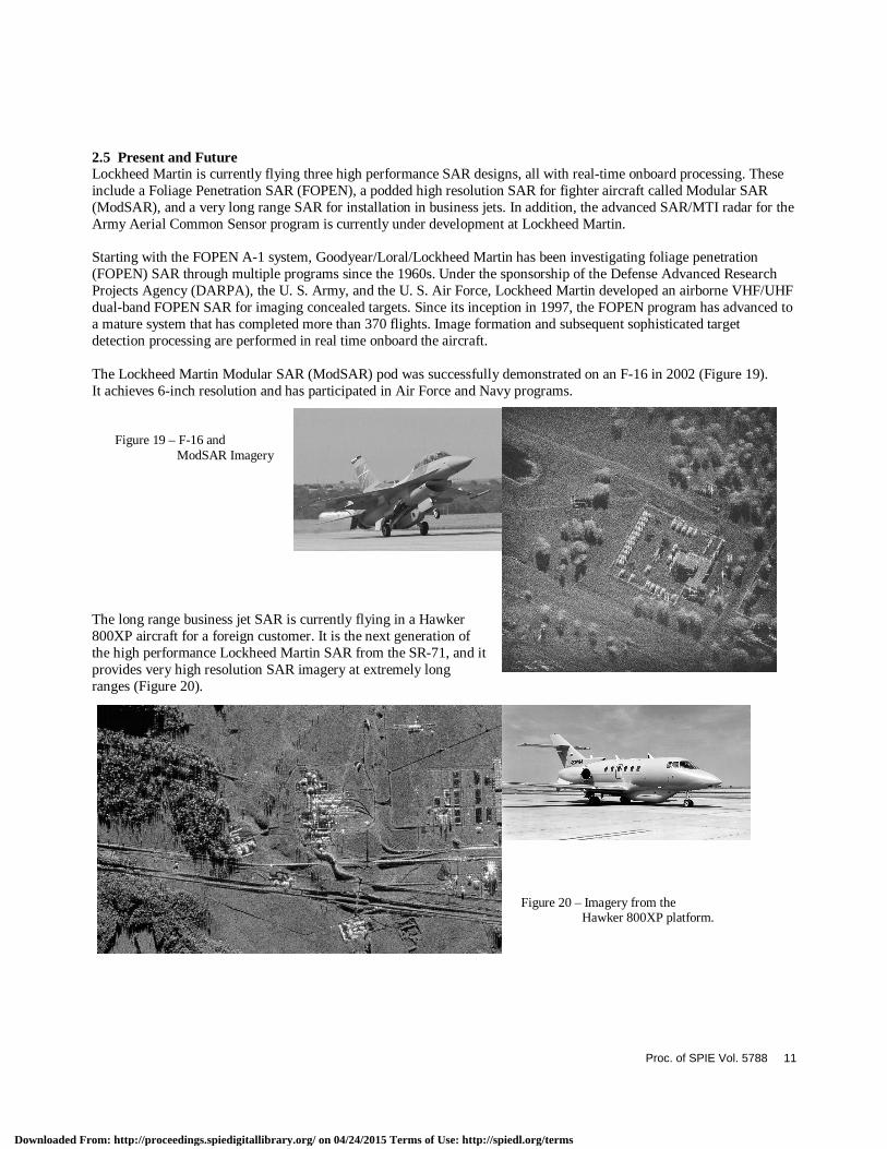
2.5 Present and Future Lockheed Martin is currently flying three high performance SAR designs, all with real-time onboard processing. These include a Foliage Penetration SAR (FOPEN), a podded high resolution SAR for fighter aircraft called Modular SAR (ModSAR), and a very long range SAR for installation in business jets. In addition, the advanced SAR/MTI radar for the Army Aerial Common Sensor program is currently under development at Lockheed Martin. Starting with the FOPEN A-1 system, Goodyear/Loral/Lockheed Martin has been investigating foliage penetration (FOPEN) SAR through multiple programs since the 1960s. Under the sponsorship of the Defense Advanced Research Projects Agency (DARPA), the U. S. Army, and the U. S. Air Force, Lockheed Martin developed an airborne VHF/UHF dual-band FOPEN SAR for imaging concealed targets. Since its inception in 1997, the FOPEN program has advanced to a mature system that has completed more than 370 flights. Image formation and subsequent sophisticated target detection processing are performed in real time onboard the aircraft. The Lockheed Martin Modular SAR (ModSAR) pod was successfully demonstrated on an F-16 in 2002 (Figure 19). It achieves 6-inch resolution and has participated in Air Force and Navy programs. Figure 19 – F-16 and ModSAR Imagery The long range business jet SAR is currently flying in a Hawker 800XP aircraft for a foreign customer. It is the next generation of the high performance Lockheed Martin SAR from the SR-71, and it provides very high resolution SAR imagery at extremely long ranges (Figure 20). Figure 20 – Imagery from the Hawker 800XP platform.
Proc. of SPIE Vol. 5788 11
Downloaded From: http://proceedings.spiedigitallibrary.org/ on 04/24/2015 Terms of Use: http://spiedl.org/terms

Lockheed Martin is currently developing the advanced SAR/MTI system for the Army Aerial Common Sensor (ACS) program (Figure 21).
Figure 21 – Drawing of configured ACS aircraft.
3. CONCLUSION The story of SAR at Lockheed Martin is a story of genius, of hard work, and of imagination. It is the story of teams of talented minds working through the decades, making discoveries based on the vision of one man. In only five decades, SAR has made incredible advancements–it is absolutely astonishing to see how far we’ve come since the beginning. Lockheed Martin is extremely proud of the role it has played in this exciting and necessary technology, and it is our hope, and educated guess, that where we stand today is but a drop in the SAR bucket compared to where we will stand another fifty years from now.
12 Proc. of SPIE Vol. 5788
Downloaded From: http://proceedings.spiedigitallibrary.org/ on 04/24/2015 Terms of Use: http://spiedl.org/terms