Locke Historic District USDI/NPS NRHP Registration Form (Rev. 8 ...
37
NFS Form 10-900 Locke Historic District OMB No. 1024-0018 Page 1 USDI/NPS NRHP Registration Form (Rev. 8-86) United States Department of the Interior, National Park Service National Register of Historic Places Registration Form 1. NAME OF PROPERTY Historic Name: Locke Other Name/Site Number: Locke Historic District 2. LOCATION Street & Number: City/Town: Locke State: CA County: Sacramento ______Not for publication:___ Vicinity:___ Code: 067 Zip Code: 95690 3. CLASSIFICATION Ownership of Property Private: X Public-local: X Public-State:__ Public-Federal: Category of Property Building(s):__ District: X Site:__ Structure:__ Object:__ Number of Resources within Property Contributing 53 54 Noncontributing ____ buildings 1 sites 2 structures ____ objects 3 Total Number of Contributing Resources Previously Listed in the National Register: 54 Name of related multiple property listing:
-
Upload
nguyencong -
Category
Documents
-
view
217 -
download
0
Transcript of Locke Historic District USDI/NPS NRHP Registration Form (Rev. 8 ...
NFS Form 10-900
Locke Historic District
OMB No. 1024-0018
Page 1
USDI/NPS NRHP Registration Form (Rev. 8-86)United States Department of the Interior, National Park ServiceNational Register of Historic Places Registration Form
1. NAME OF PROPERTY
Historic Name: Locke
Other Name/Site Number: Locke Historic District
2. LOCATION
Street & Number:
City/Town: Locke
State: CA County: Sacramento
______Not for publication:___
Vicinity:___
Code: 067 Zip Code: 95690
3. CLASSIFICATION
Ownership of PropertyPrivate: X
Public-local: X Public-State:__
Public-Federal:
Category of Property Building(s):__
District: XSite:__
Structure:__Object:__
Number of Resources within Property Contributing
53
54
Noncontributing ____ buildings
1 sites2 structures
____ objects3 Total
Number of Contributing Resources Previously Listed in the National Register: 54
Name of related multiple property listing:
NFS Form 10-900 OMB No. 1024-0018
Locke Historic District Page 2
USDI/NPS NRHP Registration Form (Rev. 8-86)United States Department of the Interior, National Park ServiceNational Register of Historic Places Registration Form
4. STATE/FEDERAL AGENCY CERTIFICATION
As the designated authority under the National Historic Preservation Act of 1986, as amended, I hereby certify that this ___ nomination ___ request for determination of eligibility meets the documentation standards for registering properties in the National Register of Historic Places and meets the procedural and professional requirements set forth in 36 CFR Part 60. In my opinion, the property ___ meets ___ does not meet the National Register Criteria.
Signature of Certifying Official Date
State or Federal Agency and Bureau
In my opinion, the property ___ meets ___ does not meet the National Register criteria.
Signature of Commenting or Other Official Date
State or Federal Agency and Bureau
5. NATIONAL PARK SERVICE CERTIFICATION
I, hereby certify that this property is:
___ Entered in the National Register ___________ ___ Determined eligible for the ______________
National RegisterDetermined not eligible for the __ National RegisterRemoved from the National Register Other (explain): ______________
Signature of Keeper Date of Action
NFS Form 10-900
Locke Historic District
OMB No. 1024-0018
Page 3
USDI/NPS NRHP Registration Form (Rev. 8-86)United States Department of the Interior, National Park ServiceNational Register of Historic Places Registration Form
6. FUNCTION OR USE
Historic:
Current:
Domestic Domestic Commerce/Trade Comme rce/Trade
Domestic Domestic Commerce/Trade Commerce/Trade
Sub: Single DwellingMultiple DwellingBusinessRestaurant
Sub: Single DwellingMultiple DwellingBusinessRestaurant
7. DESCRIPTION
Architectural Classification: Other
Materials:Foundation:Walls:Roof:Other:
N/AWood/ShingleN/AWood
Describe Present and Historic Physical Appearance.
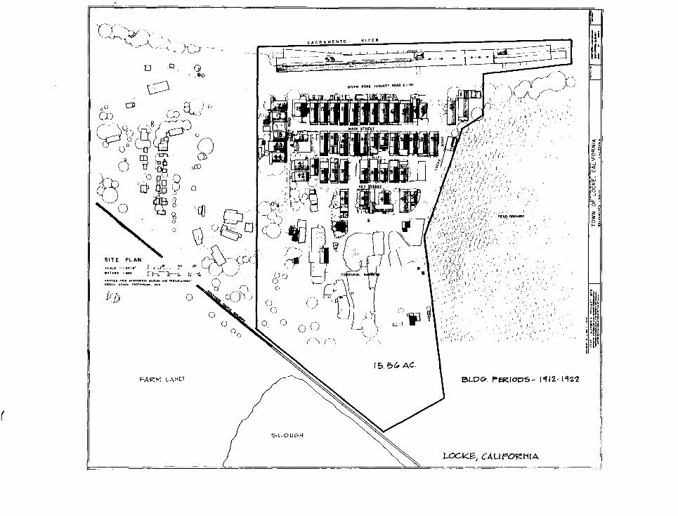
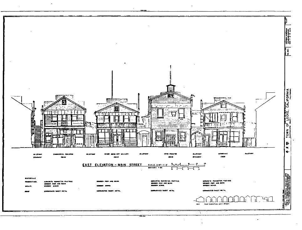
[i]The Locke Historic District covers about 14 acres of rural Sacramento County approximately 1 mile north of the town of Walnut Grove, California, along the east bank of the Sacramento River. Within the district are 53 frame buildings and major outbuildings, mostly constructed in 1916.
The 2-story buildings along River Road and Main Street housed grocery stores, boardinghouses, a bakery, a theater, a school, restaurants, a toner headquarters, gambling houses, saloons, brothels, and other commercial uses that served a largely transient population. Buildings along Key Street, mostly 1-story, were constructed as residences.
Except for a barn-mill in the communal garden, nearly all these residences and commercial buildings were erected for the Chungshan Chinese immigrants who settled there after a fire in 1915 destroyed their homes in Walnut Grove. Except for

NFS Form 10-900 OMB No. 1024-0018
Locke Historic District Page 4
USDI/NPS NRHP Registration Form (Rev. 8-86)United States Department of the Interior, National Park ServiceNational Register of Historic Places Registration Form
alterations, virtually no new construction has been undertaken in the town since the 1920s. Most of the buildings that remain are in poor or good condition. Many are quite fragile.
The site occupied by Locke was originally part of the large pear orchard to the north. The Locke family cleared the land and leased it to the Chinese late in 1915. The town was laid out in a conventional fashion to conform to existing structures, roads, and geography.
Lots began north of Tin Sin Chan's store-saloon (Building 15), built in 1912, and continued along River Road opposite the former Southern Pacific loading sheds (Building 52), begun in 1909. These lots were situated on the edge of a levee and made possible construction of buildings with entrances at both the levee level on the west and a lower flat level on the east. Main Street was then laid out to the east of these lots on the flat below the levee. This was primarily a commercial area. Key Street, parallel to Main to its east, was planned for residential construction. Locke Road and Levee Road marked the northern and southern limits, respectively. Several outbuildings and a community garden occupy the area outside the main development.
The residents of Locke paid rent for their 32' x 75' lots on the basis of use. Commercial lots rented for $10; residential lots for $5. Construction began in 1915, and, within 2 years, 45 buildings had been erected. All construction was completed by the early 1920s. Although built for the Chinese, the buildings were mostly erected by Caucasian contractors along conventional lines typical of the region. Even if they could have afforded it and had been permitted to own the land, the Chinese may have considered brick and stone too expensive for what many viewed as a temporary stay in the united States. The buildings were constructed of wood frame, often left unpainted, with cheap and relatively fire-resistant corrugated metal roofs. The style of the 1-story and 2-story buildings has been referred to as "riverfront woodcutter's Gothic commercial," a vernacular style popular in the West, beginning some 50 years before the settlement of Locke. Locke's buildings are a functional statement of architecture designed to serve a particular geographic need, and are patterned after a "rural vernacular," which typically employs a rectangular plan, gable roofs, false fronts, drop siding, and second-story balconies.
NFS Form 10-900 OMB No. 1024-0018
Locke Historic District Page 5
USDI/NPS NRHP Registration Form (Rev. 8-86)United States Department of the Interior, National Park ServiceNational Register of Historic Places Registration Form
The most striking evidences of Chinese presence in the buildings' features are the decorative paints used on some buildings and the use of ideographs and signboard calligraphy in windows, on building walls, and on hanging boards. These ideographs were a form of advertising but also were thought to be imbued with mystical powers that would bring good fortune.
COMMERCIAL-RESIDENTIAL BUILDINGS
Locke businessmen erected the 2-story frame buildings along River Road and Main Street for combination commercial and residential use. The three oldest of these (Buildings 15, 16, and 19) predate the founding of Locke, having been built in 1912. The other commercial-residential buildings in Locke were constructed north of the 1912 ones within a few years after the founding, most of them ca. 1915.
Tin Sin Chan Store (Building 15)
At the northeast corner of River and Levee Roads, this store-bar was constructed by its namesake Chinese entrepreneur, also known as Chan Tin-sen. [2] It is one story on the levee (River Road) side, but, like other buildings similarly placed along the edge of the levee, an additional lower story can be entered from the rear on Main Street.
Measuring 43' x 42', this wood building features a "boomtown" false front on the 3-bay west facade with a front porch that extends around the west and south sides. Part of the porch on the south side has been enclosed with vertical beaded boards. Except for the lower floor on Main Street, which is board-and- batten, the exterior walls are covered with wooden drop siding. The main entrance is in the diagonal of the southwest corner.
Chan's store-saloon served workers at the Southern Pacific loading sheds across River Road. It also operated as a boardinghouse and gambling parlor. The building, which is in fair condition, now houses a restaurant.
Wing Choy Owyung Hotel (Wing-chonq Owyoung Rooming House) (Building 16)
Across Levee Road to the south, on the southeast corner of the intersection with River Road, this is a 3-story boardinghouse or
NFS Form 10-900 OMB No. 1024-0018
Locks Historic District Page 6
USDI/NPS NRHP Registration Form (Rev. 8-86)United States Department of the Interior, National Park ServiceNational Register of Historic Places Registration Form
hotel, 25' x 50', with its 5-bay main facade facing north. The building, currently in a deteriorated state, is of wood, covered with drop siding. The first floor is below the level of Levee Road. The upper story on the main facade has an enclosed porch extending over a first-floor open porch and a hipped roof with hipped dormer. A portion of the open porch that continued along the west side of the building has been enclosed; it is covered by a sheet metal shed roof. A small wooden accessory structure in poor condition abuts the southwest corner of the hotel; it has board-and-batten siding but no features of distinction.
The hotel also catered to the largely male labor force at the loading sheds; its present use is residential.
This 2-story building was put up to the east of Chan's store. It is oriented toward Levee Road, rather than Main Street. It served as a prototype for other 2-story buildings erected in Locks. Sheathed in vertical board-and-batten siding, except on its east facade which has wooden drop siding, this is a frame building with a gable roof. It measures 20' across its 3-bay front by 42' deep. In fair condition, it now serves as a residence.
BUILDINGS 2. 4/5-14
These buildings between River Road and Main Street were apparently erected shortly before others in Locke and incorporate similar architectural features. Building 2, just north of Locke Road, forms part of this group.
Only the top floors of these 2-story buildings are visible and accessible from River Road, because they are built into the side of the levee. The buildings are entered on this side from wooden footbridges that span the drop from the levee and River Road and connect with a boardwalk running in front of the buildings. Each building features a boomtown false front, which conceals the roof behind, and, with the exception of the Star Theater (Building 9), a full-width shed roof porch extending over the boardwalk. The boardwalk rests atop the lower floors.
The east (Main Street) facades rise a full 2 stories. Building 6 features a boomtown facade, but low gabled roofs top the others.
NFS Form 10-900 OMB No. 1024-0018
Locke Historic District Page 7
USDI/NPS NRHP Registration Form (Rev. 8-86)United States Department of the Interior, National Park ServiceNational Register of Historic Places Registration Form
Second-story balconies extend over the sidewalks to the edge of Main Street, creating a covered walkway the length of the street.
These buildings were constructed so that the first and second floors could be used for separate stores or businesses, each with its own entrance on River Road or Main Street. The rear portions of each floor often housed the owner and his family or were rented out to transients.
Alleys between the buildings, roughly 8' in width, were provided for fire safety. They were, and are, typically used for storage and hanging laundry. Some have boardwalks, with stairs, running through them that accommodate the change in street level. Others are mere planks.
Yuen Chona Market (Buildings 4-5)
Of this group, only the Yuen Chong Market appears to have been heavily altered. This 2-story wood frame building, 38' x 60', reportedly built by a cooperative in 1915, was the town's first grocery. Although it now has a stuccoed false front gable in its 4-bay west facade, which gives it a faintly "Baroque" flavor, it still houses a grocery operating under the same name. The market is in excellent condition.
The upper level earlier housed the drygoods sold by the store. The east facade, which now has a wood canopy at the first-floor level, appears to have had its roof raised. Two small shed-roof additions on the south side of the building house refrigeration equipment.
To the north there is a small 2-story residence in the alleyway. The first level has wooden siding and part of it is enclosed with vertical and horizontal slats for storage space. The second level has corrugated sheet metal walls and a gable roof of corrugated sheet metal.
Other Buildings
Other buildings in this group include the Star Theater (Building 9), the Bakery and Lunch Parlor (Building 8), and Wah Lee and Co. Dry Goods Store (Building 7).
NFS Form 10-900 OMB No. 1024-0018
Locks Historic District Page 8
USDI/NPS NRHP Registration Form (Rev. 8-86)United States Department of the Interior, National Park ServiceNational Register of Historic Places Registration Form
BUILDINGS 20-31 EAST SIDE OF MAIN STREET
Across Main Street stands another group of commercial-residential buildings. Those numbered 20, 21, 23, and 25-27 are 2-story frame buildings with facades similar to those on the west side. Building 23, like Building 6, features a boomtown false front, but low end gables top the others. All have overhanging second- floor balconies. Buildings 22, 24, and 28-31 are 1- and 1-1/2 story. Building 29 has the same boomtown facade and overhanging shed roof found on the River Road facades of Buildings 5-14. The others have simple low end gables above the shed roofs. As on the west side of the street, balconies and shed roofs overhang the sidewalk and provide a sheltered walkway the full length of the street.
Jan Yinq ("Handsome/Brave Industrial Commercial") Association (Building 23)
The headquarters of this association is in Building 23. The bright yellow building, 24' x 35', features green trim and red entrance doors; it is 2 stories high and 4 bays wide, with a 2- story porch overhanging the sidewalk on the main (west) facade. It has wooden drop siding and a board-and-batten 1-story lean-to addition, 25' deep, on the east side. The alleyways on both sides are closed off with doors and conceal storage areas. The association, which is still active, has been variously described as a benevolent and social association and a merchants' organization. The building is in good condition.
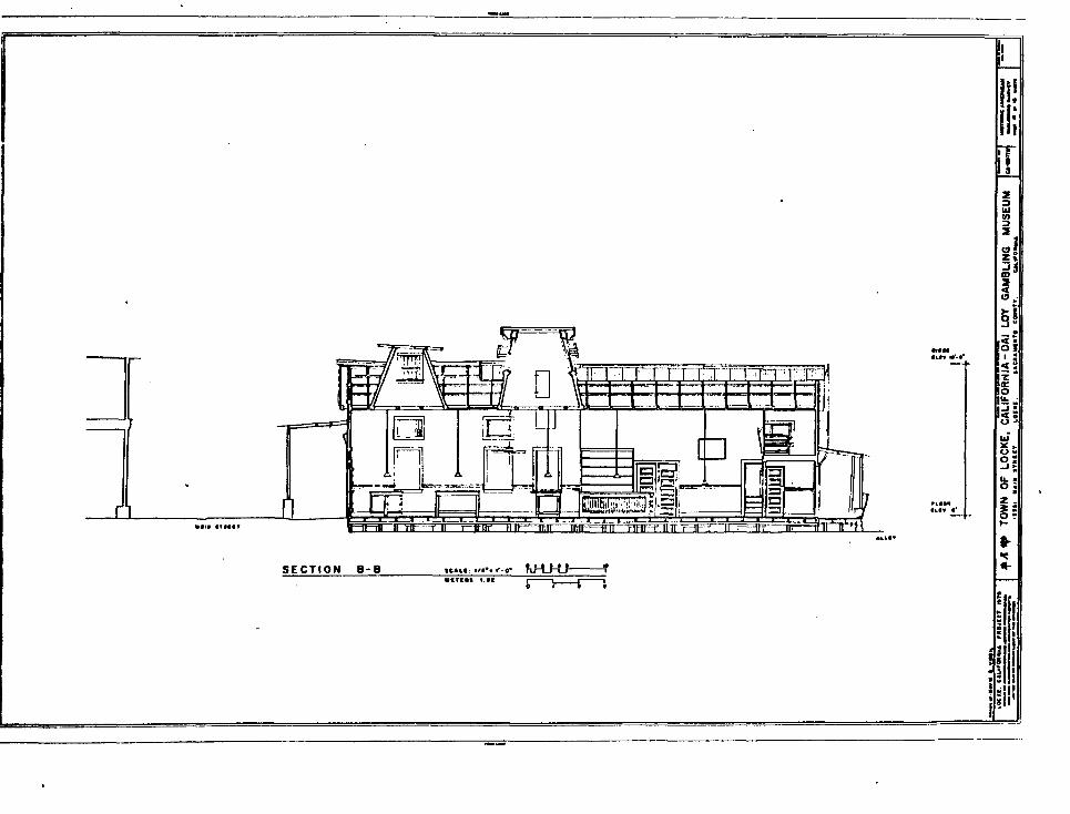
Dai Lov ("Big Welcome") Gambling House (Building 22)
The Sacramento River Delta Historical Society operates this former gambling hall as a museum. The building's dimensions are 24' x 60'; it is 2 stories with a 1-story addition. The main block is covered with wooden drop siding; the lean-to addition on the southeast is board and batten. A 1-story shed roof canopy covers the concrete sidewalk in front of the building.
On the south side, a covered alleyway with a wooden floor connects with Building 21, creating a 2-bay porch at the extreme east end of the 3-bay main block. The alleyway has a molded arch entrance on the west facade with an engaged pilaster at both sides. The east, or alley, facade has a plain and somewhat deteriorated shed-roof porch.
NFS Form 10-900 OMB No. 1024-0018
Locke Historic District Page 9
USDI/NPS NRHP Registration Form (Rev. 8-86)United States Department of the Interior, National Park ServiceNational Register of Historic Places Registration Form
After Sacramento County law enforcement officials closed the hall down in 1950, the building was used as a storehouse. The Society has restored the interior layout and furnishings of the gambling hall to their 1916 appearance. The Central Gaming Hall has five tables, set in mid-game. The Lottery Room and Money Room the latter with the original safe are also of interest. The windows are blind as they were during gambling days. The building is in fair condition.
Al's Place ("Al the WOP'S") (Building 24)
One of Locke's most famous establishments is located in this group, in Building 24. Al Adami, an Italian-American from San Francisco's North Beach, set up a saloon and steak place in this building in 1924, succeeding an earlier restaurant operated by Lee Bing. Al's has remained in operation ever since with the same simple menu.
Unlike most of the buildings in the Main Street row, Al's lacks a false front, but has a shed roof canopy supported by four plain wooden posts that covers the Main Street sidewalk fronting it. It is 1-1/2 stories. Measuring 23' across the 3-bay front, the building is 60' deep, and has lean-to additions on the east rear and in the alleyways, it is covered with narrow wood board siding except for the additions, which have drop siding. The unique interior decor consists of tongue-and-groove interior walls and wadded up dollar bills stuck to the ceiling. "Al's Place" is in good condition.
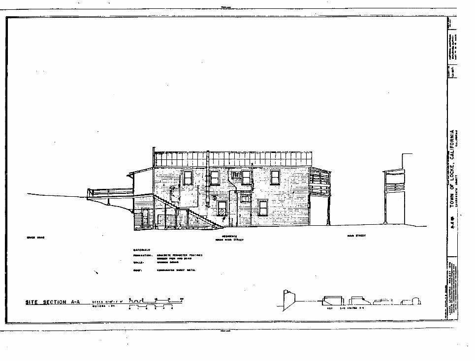
RESIDENTIAL BUILDINGS
Many of Locke's residents lived above or behind their businesses on River Road and Main Street, but 1-story houses were also constructed on both sides of Key Street (Buildings 32-42, 45-47, and 49-50) and on the south side of Levee Road (Buildings 17-18 and 43-44). These are generally simple rectangular frame buildings with end gables above either shed-roofed porches or small inset corner porches. Only Building 45 stands 2 stories, with a gabled roof sloping down toward the front facade.
NFS Form 10-900 OMB No. 1024-0018
Locke Historic District Page 10
USDI/NPS NRHP Registration Form (Rev. 8-86)United States Department of the Interior, National Park ServiceNational Register of Historic Places Registration Form
COMMUNITY BUILDINGS
Two buildings were constructed to serve the Locke community in general.
Joe Shoona Language School (Nationalist Party Hall) (Building 3)
This tall 1-1/2-story vernacular frame building was one of the first built in the town, in 1915, and probably served originally as the town hall, as well as the Nationalist Party (Kuomintanq) headquarters. Support for the Party was strong in Locke because its founder, Dr. Sun Yat-sen, was Chungshanese. Later Joe Shoong, a wealthy merchant, endowed the Chinese language school, held in this building, to supplement public school education provided in Walnut Grove.
The school is the first building at the north end on the west side of Main Street and is set back compared to other buildings in the row. It also has no access from River Road.
The rectangular building (20' x 50') features drop siding with a shingled end gable. The gabled roof of the cream-painted building slopes down over a porch that extends across the 3-bay main, or east, facade and around the north side. The interior is basically one large room.
This is one of the few buildings in Locke constructed with a foundation, and it remains in excellent condition. Privately owned, the school is shown by appointment.
Chinese Baptist Christian Center (Building 48)
Constructed in 1922, the center consists of a 1-story frame building, 32' x 35', with a boomtown front facade, obviously of Spanish Mission Revival derivation, facing west from the east side of Key Street, and a 2-story frame rear wing, 20' x 52', set at a right angle to the main block. The building is in good condition.
Built as part of a mission effort, the Center's Caucasian directors rather unsuccessfully attempted to Christianize the residents of Locke. The mission closed in 1965, and the building is now used for various charitable and religious functions. It is owned by the Walnut Grove Community Church.
NFS Form 10-900 OMB No. 1024-0018
Locke Historic District Page 11
USDI/NPS NRHP Registration Form (Rev. 8-86)United States Department of the Interior, National Park ServiceNational Register of Historic Places Registration Form
OTHER FEATURES
Barn-Mill
An old wood barn is southeast of Building 45 in the communal gardens. The Locke family reportedly built this building before the establishment of the town. It has been used for storage and as a mill.
Communal Garden
The 9-acre garden dates from the 1930s, when economic hard times forced the residents to begin growing much of their own food. They still tend the garden and grow tomatos, winter melons, bok choy, Chinese cabbage, bitter melon, snow peas, apricots, loquats, and other vegetables and fruits.
BUILDING-BY-BUILDING INVENTORY
All extant principal buildings and features are classed as contributing (except the wells, several garages, and small sheds, which do not contribute). [3] All are of a rural vernacular style, sometimes labeled "riverfront woodcutter's Gothic commercial," and all date from ca. 1915-16, except Buildings 15, 16, 19, and 48, discussed individually above. (Fuller descriptions of most buildings, including details of finishes, fenestration, floor plans, etc., can be found in the Historic American Buildings Survey materials.)
1. Jack Ross Gas Station-Garage River Road, adjacent to 2.
2. Jack Ross BoardinahouseNortheast corner, River and Locke Roads(See discussion above under heading Buildings 2, 5-14.)
3. Joe Shoong Language School (Nationalist Party Hall) 13920 Main Street (See individual discussion above.)
4/5. Yuen Chong ("Flourishing Source") Market13923 River Road (west side); 13924 Main Street (eastside).(See individual discussion above.)
NFS Form 10-900 OMB No. 1024-0018
Locke Historic District Page 12
USDI/NPS NRHP Registration Form (Rev. 8-86)United States Department of the Interior, National Park ServiceNational Register of Historic Places Registration Form
6. 13927 River Road; 13928 Main Street (site) Dimensions: 24' x 60'Notes: 2-story with wooden drop siding. False fronts on the 3-bay east and west facades. Vertical wooden siding covered the west facade's first floor, which was sheltered by a shed roof. On the east, a shed-roofed balcony projected over the sidewalk. (This structure burned in 1984.)
7. Wah Lee & Co. Dry Goods Store13931 River Road; 13932 Main StreetDimensions: 24' x 60'Notes: 2-story, 3-bay, of wooden drop siding, falsefront on west facade; shed-roofed canopies shelter thewest facade and the first level on the east.Specialized in boots and drygoods and groceries on theRiver Road upper level. Vacant.
8. Japanese Bakery and Lunch Parlor 13936 Main Street Dimensions: 25' x 60'Notes: 2-story with wooden drop siding and false front on west side. A shed roof overhangs the boardwalk across that facade. The 4-bay east facade has a bi- level porch, in deteriorated state, which overhangs the sidewalk. A gambling hall in the 1920s; the bakery was on the lower level, the residence on the upper. Now a residence. Except for the eastern porch, the structure appears in sound condition.
9. Star Theater13939 River Road Dimensions: 25' x 60'Notes: 2-1/2-story, 3-bays, covered with mostly wooden drop siding. False front on west facade with a large arched entranceway unique in Locke, featuring a sloping pediment and shallow arch ornamented by dentilling and supported by simple pilasters. The building previously featured side balconies; the balcony extending over the sidewalk on the east facade has been enclosed. Over the alleys to either side on the east facade are arched wooden openings joined to the adjacent buildings that served to guide patrons up stairs, in the alleys, to the River Road side and into the theater. Built as a theater and used also as a movie house; it also served
NFS Form 10-900 OMB No. 1024-0018
Locke Historic District Page 13
USDI/NPS NRHP Registration Form (Rev. 8-86)United States Department of the Interior, National Park ServiceNational Register of Historic Places Registration Form
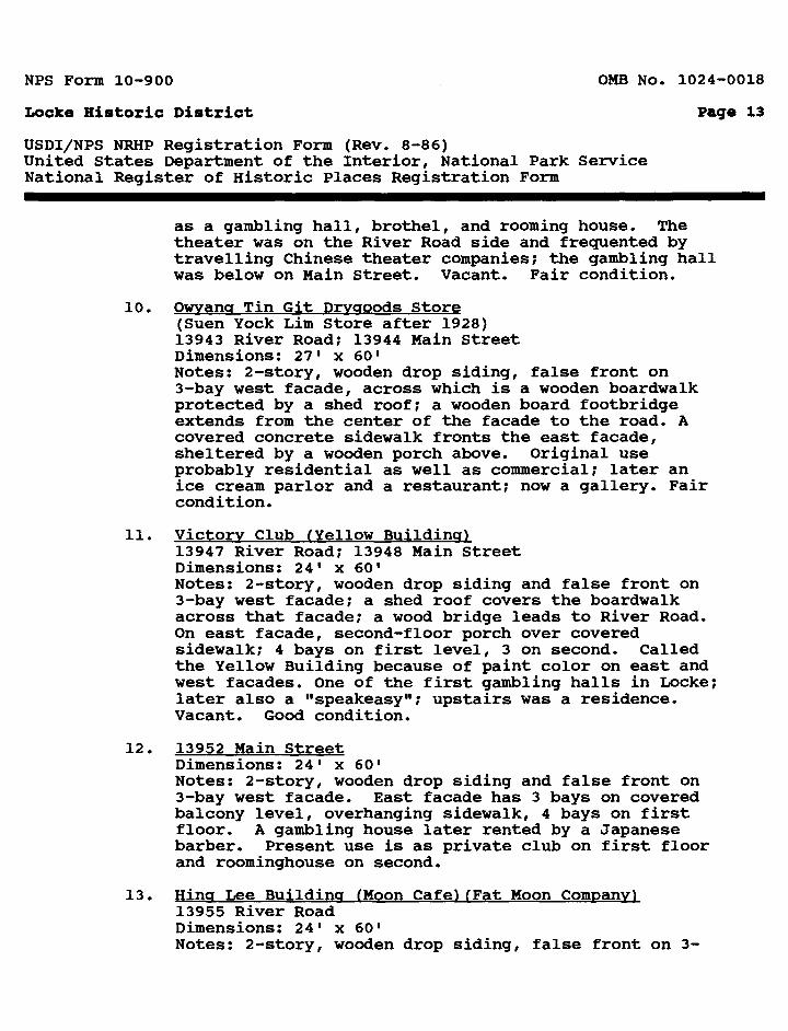
as a gambling hall, brothel, and rooming house. The theater was on the River Road side and frequented by travelling Chinese theater companies; the gambling hall was below on Main Street. Vacant. Fair condition.
10. Owyang Tin Git Dryaoods Store(Suen Yock Lim Store after 1928) 13943 River Road; 13944 Main Street Dimensions: 27' x 60'Notes: 2-story, wooden drop siding, false front on 3-bay west facade, across which is a wooden boardwalk protected by a shed roof; a wooden board footbridge extends from the center of the facade to the road. A covered concrete sidewalk fronts the east facade, sheltered by a wooden porch above. Original use probably residential as well as commercial; later an ice cream parlor and a restaurant; now a gallery. Fair condition.
11. Victory Club (Yellow Building)13947 River Road; 13948 Main Street Dimensions: 24' x 60'Notes: 2-story, wooden drop siding and false front on 3-bay west facade; a shed roof covers the boardwalk across that facade; a wood bridge leads to River Road. On east facade, second-floor porch over covered sidewalk; 4 bays on first level, 3 on second. Called the Yellow Building because of paint color on east and west facades. One of the first gambling halls in Locke; later also a "speakeasy"; upstairs was a residence. Vacant. Good condition.
12. 13952 Main StreetDimensions: 24' x 60'Notes: 2-story, wooden drop siding and false front on 3-bay west facade. East facade has 3 bays on covered balcony level, overhanging sidewalk, 4 bays on first floor. A gambling house later rented by a Japanese barber. Present use is as private club on first floor and roominghouse on second.
13. Hincf Lee Building (Moon Cafe) (Fat Moon Company) 13955 River Road Dimensions: 24' x 60' Notes: 2-story, wooden drop siding, false front on 3-
NFS Form 10-900 OMB No. 1024-0018
Locke Historic District Page 14
USDI/NPS NRHP Registration Form (Rev. 8-86)United States Department of the Interior, National Park ServiceNational Register of Historic Places Registration Form
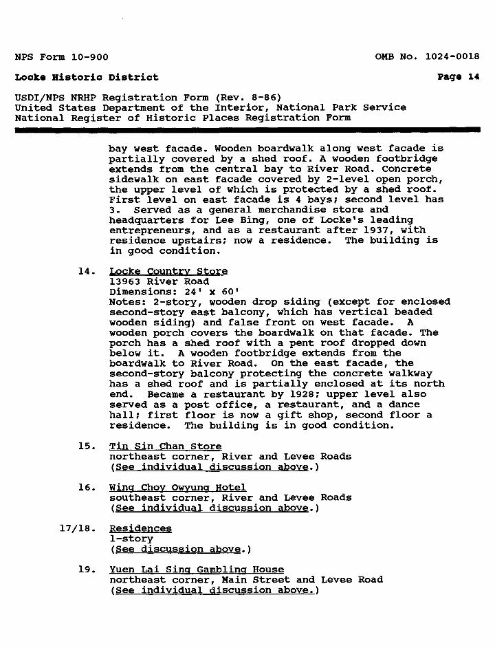
bay west facade. Wooden boardwalk along west facade is partially covered by a shed roof. A wooden footbridge extends from the central bay to River Road. Concrete sidewalk on east facade covered by 2-level open porch, the upper level of which is protected by a shed roof. First level on east facade is 4 bays; second level has 3. Served as a general merchandise store and headquarters for Lee Bing, one of Locke's leading entrepreneurs, and as a restaurant after 1937, with residence upstairs; now a residence. The building is in good condition.
14. Locke Country Store 13963 River Road Dimensions: 24' x 60'Notes: 2-story, wooden drop siding (except for enclosed second-story east balcony, which has vertical beaded wooden siding) and false front on west facade. A wooden porch covers the boardwalk on that facade. The porch has a shed roof with a pent roof dropped down below it. A wooden footbridge extends from the boardwalk to River Road. On the east facade, the second-story balcony protecting the concrete walkway has a shed roof and is partially enclosed at its north end. Became a restaurant by 1928; upper level also served as a post office, a restaurant, and a dance hall; first floor is now a gift shop, second floor a residence. The building is in good condition.
15. Tin Sin Chan Storenortheast corner, River and Levee Roads (See individual discussion above.)
16. Wing Chov Owyung Hotelsoutheast corner, River and Levee Roads (See individual discussion above.)
17/18. Residences 1-story (See discussion above.)
19. Yuen Lai Sing Gambling Housenortheast corner, Main Street and Levee Road (See individual discussion above.)
NFS Form 10-900 OMB No. 1024-0018
Locke Historic District Page 15
USDI/NPS NRHP Registration Form (Rev. 8-86)United States Department of the Interior, National Park ServiceNational Register of Historic Places Registration Form
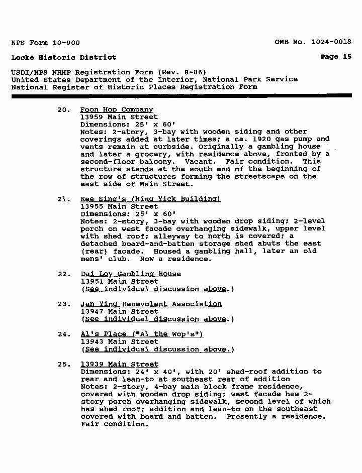
20. Foon Hop Company 13959 Main Street Dimensions: 25' x 60'Notes: 2-story, 3-bay with wooden siding and other coverings added at later times; a ca. 1920 gas pump and vents remain at curbside. Originally a gambling house and later a grocery, with residence above, fronted by a second-floor balcony. Vacant. Fair condition. This structure stands at the south end of the beginning of the row of structures forming the streetscape on the east side of Main Street.
21. Kee Sing's (King Yick Building) 13955 Main Street Dimensions: 25' x 60'Notes: 2-story, 3-bay with wooden drop siding; 2-level porch on west facade overhanging sidewalk, upper level with shed roof; alleyway to north is covered; a detached board-and-batten storage shed abuts the east (rear) facade. Housed a gambling hall, later an old mens 1 club. Now a residence.
22. Dai Loy Gambling House 13951 Main Street (See individual discussion above.)
23. Jan Yina Benevolent Association 13947 Main Street (See individual discussion above.)
24. Al's Place ("Al the Wop's") 13943 Main Street (See individual discussion above.)
25. 13939 Main StreetDimensions: 24' x 40', with 20' shed-roof addition to rear and lean-to at southeast rear of addition Notes: 2-story, 4-bay main block frame residence, covered with wooden drop siding; west facade has 2- story porch overhanging sidewalk, second level of which has shed roof; addition and lean-to on the southeast covered with board and batten. Presently a residence. Fair condition.
NFS Form 10-900 OMB No. 1024-0018
Locks Historic District Page 16
USDI/NPS NRHP Registration Form (Rev. 8-86)United States Department of the Interior, National Park ServiceNational Register of Historic Places Registration Form
26. Fish Market13935 Main Street Dimensions: 24' x 60'Notes: 2-story, 3-bay with wooden drop siding and board and batten on a rear addition. Bilevel porch projects over sidewalk and is covered by a shed roof. There is a covered balcony at the northern end of the addition. Housed a fish market on the first floor and a residence on the second. Now a residence. Very good condition.
27. Drug Store13931 Main StreetDimensions: 24' x 40', with a 20' eastern addition Notes: 2-story, 4-bay, wooden drop siding, except on addition which is board and batten. A high second- floor balcony protects the sidewalk. Began as a gambling hall; as a drug store, it dispensed Chinese herbal medicines, as well as Occidental ones; now a residence. Good condition.
28. 13927 Main StreetDimensions: 24' x 70'Notes: 1-story, 3-bay, with a shed-roof porch overhanging the Main Street sidewalk; wooden drop siding; a major 2-story addition perpendicular on the rear but with similar siding and gable roof. Always a residence. Good condition.
29. 13923 Main StreetDimensions: 25' x 60'Notes: 1-story, 2-bay, wooden drop siding; only building of its kind in Locks, with a curved false front, featuring a curved pediment anchored by short decorative piers and a balcony, and a shed roof overhanging the sidewalk. Wide entrance door. Has served as a movie theater and warehouse. Poor condition.
30. 13919 Main StreetDimensions: 24' x 60'Notes: 1-story frame residence with a gable roof; the 4-bay west front is sheltered by a simple shed roof porch; shed-roof additions to the north and south sides and a gable-roofed rear addition; structure is covered with wooden drop siding, except for the north and south
NFS Form 10-900 OMB No. 1024-0018
Locks Historic District Page 17
USDI/NPS NRHP Registration Form (Rev. 8-86)United States Department of the Interior, National Park ServiceNational Register of Historic Places Registration Form
sides of the rear (east) addition, which are board and batten, and the shed-roof additions, which are clad with narrow vertical boards. Once divided into six apartments; now a single family residence. Fair condition.
31. 13915 Main StreetDimensions: 24' x 60'Notes: 1-story, 3-bay, wooden drop siding on east and west facades, board and batten on the side walls. The west facade has a shed-roofed porch; the east a gable- roofed one, and a third porch, with a shed roof, extends along the south side of the house. Built as a 2-family residence; now converted to 1-family use.
32/47. Residences1-story, except for Building 45, which is 2-story. (See discussion above and next item.)
35. Residence13940 Key StreetDimensions: 24' x 60'Notes: 1-story, 3-bay, facing east; gable roof; woodendrop siding; west addition of board and batten; mainentrance porch is inset in northeast corner; smallwooden outbuilding with shed roof behind addition.Typical of residential construction in Locks.
48. Chinese Baptist Christian Center (See individual discussion above.)
49/51. Residences 1-story (See discussion above.)
Shed, east of building 49
Shed, east of building 51
Communal Garden and Barn-Mill(See individual discussion above.)
WellsThe two wells, at the north and south ends of the village, have been used historically, but have no
NFS Form 10-900 OMB No. 1024-0018
Locke Historic District Page 18
USDI/NPS NRHP Registration Form (Rev. 8-86)United States Department of the Interior, National Park ServiceNational Register of Historic Places Registration Form
specific attributes that contribute to Locke's historic significance.
Endnote
1. This description and inventory of Locke is based on therevised National Register of Historic Places nomination form prepared by John White and Christopher Yip in 1979 and on materials prepared by the Historic American Buildings Survey project in Locke led by John White in 1979-80.
2. Certain Asian cultures, notably Chinese and Vietnamese, give the family name first, the given name last, exactly contrary to Western conventions. For example, Reagan Wilson Ronald, rather than Ronald Wilson Reagan. In anglicizing their names, Asian-Americans have followed a variety of patterns, sometimes reversing the order of their names; in other instances adopting their Asian family names as their given names. Some individuals have used both methods at various times, as in this case, complicating the task of properly assigning names to buildings and opening the door to some measure of confusion.
3. The Southern Pacific Railroad Loading Shed (Boat House), Building 52, on the west side of River Road, recently burned. Loading or packing sheds had been present at this site on the Sacramento River as early as the 1880s. The 1-story wood-frame loft building, however, was begun in 1909 by the Southern Pacific Railroad after the extension of a rail line into the area in 1907. Construction of the cor rugated sheet metal shed, 40' x 880', was completed by 1927. Various packing companies rented space in it. It ran along the edge of the levee abutting the river.
This site is not included in the boundary.
NFS Form 10-900 OMB No. 1024-0018
Locke Historic District Page 19
USDI/NPS NRHP Registration Form (Rev. 8-86)United States Department of the Interior, National Park ServiceNational Register of Historic Places Registration Form
8. STATEMENT OF SIGNIFICANCE
Certifying official has considered the significance of this property in relation to other properties: Nationally; X Statewide:__ Locally:_
Applicable NationalRegister Criteria: A X B__ C X D_
Criteria Considerations (Exceptions): A__ B_
NHL Criteria: 1, 5
Areas of Significance: Period(s) of Significance Significant Dates Ethnic Heritage: 1915-1940 _________ Asian
NHL Themes: XXX. American Ways of LifeE. Ethnic Communities: Chinese-Americans
Significant Person(s): N/A
Cultural Affiliation: N/A
Architect/Builder: Unknown
State Significance of Property, and Justify Criteria, Criteria Considerations, and Areas and Periods of Significance Noted Above.
B«mitiai-y [1]
The Locke Historic District in Sacramento County, California, is "the largest and most complete example of a rural Chinese- American community" [2] in the United States. Locke was the last rural Chinese community established in the Sacramento-San Joaquin delta and is the last remaining. Although individual buildings associated with rural Chinese-American life survive, no comparable district exists that so clearly illustrates this little-known phase in the history of the Chinese in America.
NFS Form 10-900 0MB No. 1024-0018
Locke Historic District Page 20
USDI/NPS NRHP Registration Form (Rev. 8-86)United States Department of the Interior, National Park ServiceNational Register of Historic Places Registration Form
Partly, this is because most Chinese-Americans were long prevented from owning land in California. Thus, Locke's land tenure, where the Chinese have owned the buildings but never the land, is a legacy of anti-Asian discrimination.
Locke's survival, while Chinese-Americans generally became increasingly urbanized, arose from the combined economic impact of the asparagus canning industry, a transient farm labor force, and illegal activities during the Prohibition era. The town's persistence after economic incentives disappeared, however, reflects the deeply rooted social organization of the community and the common bonds of language and tradition. The Locke district thus effectively illustrates both the Chinese-American community's interaction with the larger society and economy and the survival of this ethnic way of life.
The Locke Historic District includes more than 50 frame buildings and several outbuildings, of both commercial and residential character, and covers approximately 14 acres along the east bank of the Sacramento River a mile north of Walnut Grove, California. The majority of the structures were constructed for the Chinese in 1916 in what has been called "riverfront woodcutter's Gothic commercial," a vernacular style. Although deterioration has occurred, most buildings in Locke are in fair condition and constitute a unique exhibit of a once common way of life that has now otherwise disappeared.
History
Merchants and laborers from the Chungshan district, in Kwangtung Province, founded the small town of Locke in 1915 after a fire destroyed their community in nearby Walnut Grove. They secured a verbal lease on 9 acres of land owned by the George Locke family, since anti-Asian legislation prevented them from actually buying land. Within a year, the basic core of houses and places of business that comprise Locke had been built.
The background of the settlement and development of Locke can be understood only within the larger context of the history of the Chinese in America. The source and nature of Chinese immigration, the role of Chinese labor within the developing American economy, the impact of anti-Chinese nativism, and the preservation and adaptation of the ethnic group's cultural distinctiveness all determined the composition, location, function, and longevity of this small rural community. The unique insight into the Chinese-
NFS Form 10-900 OMB No. 1024-0018
Locks Historic District Page 21
USDI/NPS NRHP Registration Form (Rev. 8-86)United States Department of the Interior, National Park ServiceNational Register of Historic Places Registration Form
American experience afforded by the Locke Historic District makes it significant in understanding the ethnic dimension of American life.
Major migration of Chinese to the United States in the last half of the 19th century ensued from the combined impact of events in China and in California. Most of the immigrants came from the southern Chinese provinces of Kwangtung and Fukien, where flood, famine, and general social and economic upheaval were capped by the great Taiping Rebellion (1851-64). Unable to support their families in the midst of this chaos, many Chinese chose to emigrate, with the intention of returning home as soon as they had made their fortunes and could properly support their families. Although many nations were the object of this emigration, a substantial number some 300,000 between 1850 and 1880 made their way to the United States, the "Land of the Golden Mountain."
The initial impetus for Chinese immigration to the United States was the discovery of gold in California in 1848. Lacking money, many immigrants fell prey to the credit-ticket system, which provided cheap passage to America but at the cost of virtual indentured servitude. Merchant-creditors who provided passage for the immigrants used this initial debt dependence to manipulate the Chinese labor force to their economic advantage. The profits from this system made these labor brokers or bosses wealthy and influential community figures.
Operators of Western mining camps and railroad construction projects eagerly hired the Chinese labor gangs, until Caucasian workers, particularly in the gold mines, began to demonstrate their bitter opposition to "coolie" labor. Although prejudice and violence drove the Chinese out of mining, they contributed in a major way to the construction of the transcontinental railroad, completed in 1869. Around that time an extensive levee project in the Sacramento-San Joaquin River Delta created a new demand for Chinese labor.
The levees begun by Chinese workers eventually turned 500,000 acres of swampland into some of the State's most valuable farm land. When machinery replaced human labor in the levee project, the newly reclaimed farm land provided a new source of employ ment. With the creation of large speculative farms and a shift from wheat to fruit and vegetable cultivation, cheap Chinese
NFS Form 10-900 OMB No. 1024-0018
Locke Historic District Page 22
USDI/NPS NRHP Registration Form (Rev. 8-86)United States Department of the Interior, National Park ServiceNational Register of Historic Places Registration Form
labor and the boss system became "absolutely essential." [3] By 1884 half of the farm laborers in the State were Chinese.
During these first 30 years, prejudice increased as the numbers of Chinese immigrants swelled. The Chinese were an easy target for the frustrations and emotions of the period and became the object of a bitter campaign of prejudice and hate. According to historian Betty Lee Sung, the Chinese were
charged with being debased and servile coolies, clannish, dangerous, deceitful, and vicious ... Degenerate traits were ascribed to them ... . The workingmen accused them of undermining the white man's standard of living. [4]
The anti-Chinese movement reached the national level with the passage of the Exclusion Act in 1882, which effectively ended Chinese immigration. Still not satisfied, nativist groups continued their campaign against the "Yellow Peril" with strikes, violence, and a formidable array of punitive and harassing legislation, including the California Alien Land Act of 1913.
Resentment of Chinese agricultural workers proved particularly bitter. "Those who had entered agricultural work ... were driven from the fields, orchards, and gardens," says sociologist Stanford M. Lyman, "in a series of race-baiting strikes and riots that spread over the state every decade before the turn of the century." [5] The last concentration of rural Chinese was in the Sacramento-San Joaquin delta in Sacramento County. In the late 19th century, this area, the home of the Bartlett pear, was ranked as the pear capital of the world. Since mechanization had not yet come to the pear industry, farm operators and managers continued to depend on cheap Chinese labor, and Chinatowns thrived in rural delta towns like Rio Vista, Courtland, Isleton, and Walnut Grove.
Although these communities were established to serve the pear industry, the basis for their survival into the 20th century was the sudden expansion of asparagus production. An asparagus boom developed in the 1890s, when technological improvements in canning finally made it profitable to meet the popular demand. The delta eventually accounted for nearly 90% of the world's asparagus crop.
NFS Form 10-900 OMB No. 1024-0018
Locke Historic District Page 23
USDI/NPS NRHP Registration Form (Rev. 8-86)United States Department of the Interior, National Park ServiceNational Register of Historic Places Registration Form
The predominantly male Chinese immigrant population proved an accessible and able work force for the booming asparagus farms. Women and children still waited in China for the most part, so the Chinese laborers readily adjusted to the temporary and cyclical farm work. Bosses controlled the work force in the delta through their manipulation of jobs, debts, housing, goods, and services. They used Chinatowns in the delta communities as their bases of operation. Laborers congregated there between jobs, waiting for the brokers to direct them to the next work. Boarding and rooming houses, often owned by the bosses, accommodated this transient population. The bosses were also often the leading merchants. Their stores supplied the laborers' needs and maintained their debt dependence and obligation. The merchant bosses also catered to the recreational needs of the predominantly adult male population by providing women, drugs, and gambling. Gambling was particularly popular, since it provided not only recreation but also the possibility, however remote, of substantial financial gain.
The last such Chinatown established in the delta was Locke. It was founded in 1915 after a fire in nearby Walnut Grove destroyed the Chinese community there. Although some decided to stay and rebuild, a group originally from the Chungshan district in southeastern China decided to built their own separate town. The Chungshan Chinese constituted a minority within the larger Chinese immigration to the United States, and their "commonality of language ... gave them a communal identity and group cohesion that persists to this day." [6] Under the leadership of Lee Bing and six other merchants, the Chungshan group secured a lease on a site a mile north of Walnut Grove along the Sacramento River levee. Since the State's Alien Land Act of 1913 effectively prevented Chinese who were not American-born from owning land, the new residents had only an oral lease with the Locke family, who owned the land and the pear orchard along the north edge of the district, and for whom the town was named.
Three Chungshan entrepreneurs had already set up business at the Locke site in 1912 and built structures that served the transient labor force that worked in the asparagus fields and canneries and in the packing sheds built across River Road by the Southern Pacific in 1909. These early structures established the basic character of Locke, and in its early years the town was "more a service center for the farm laborers than a residential community." [7]
NFS Form 10-900 OMB No. 1024-0018
Locke Historic District Page 24
USDI/NPS NRHP Registration Form (Rev. 8-86)United States Department of the Interior, National Park ServiceNational Register of Historic Places Registration Form
The town was laid out along the edge of the levee, and the first buildings were erected north of Chan's store, one of the 1912 structures, along River Road, opposite the Southern Pacific loading sheds. Main Street was laid out on the flat below the levee, and a more purely residential area was established farther to the east. Along these streets 1- and 2-story frame structures were constructed in a vernacular style. More permanent materials were considered too expensive and unnecessary, since the Chinese could not own the land and many still held on to the dream of returning to their homeland. The town was quickly built up, and no further construction was initiated after the 1920s.
The commercial portion of Locke along River Road and Main Street served the transient laborers in the area. The respectable storefronts reportedly hid gambling houses and opium dens from the beginning. The town's recreational facilities and its clientele expanded after 1919, and Locke developed a reputation as a wide-open town.
Because Locke was not incorporated and had no police, it became a popular location for Prohibition-era speakeasies. These bars catered to Caucasians who drove in from surrounding cities. Drugs, gambling, and prostitution were also present. The town's population peaked in this period at 600, but rose to 1,500 on weekends. A theater, a hotel, a bakery, a lodge, nine grocery stores, six restaurants, a flour mill, two slaughter houses, and brothels, bars, gambling halls, and boardinghouses brought prosperity to the small rural community. This situation did not last long, however. The Depression began, Prohibition ended, and the asparagus industry declined. Mechanization eventually also reduced the need for unskilled farm labor.
Locke survived, however, after other rural Chinese communities perished. This relative longevity reflects the cohesion and sense of community still evident there. Bound together by a common dialect, the community turned inward to preserve its culture and protect its members. The economic decline of the area, however, made Locke less attractive to second-generation Chinese- Americans, who often sought opportunities in the cities. Only the older people remained behind, still speaking only Chinese and ignoring the intrusions of the modern world.
NFS Form 10-900 OMB No. 1024-0018
Locke Historic District Page 25
USDI/NPS NRHP Registration Form (Rev. 8-86)United States Department of the Interior, National Park ServiceNational Register of Historic Places Registration Form
Although the Alien Land Act was eventually ruledunconstitutional, the residents of Locke have never purchased the land on which their homes are located. They continued until 1977 to pay rents of $7.50 to $15 per lot to the Locke family.
Locke's future is uncertain. Its present-day notoriety arises from its historical character, but this has made it prey to development schemes as well as a substantial tourist trade. The Chinese portion, now numbering less than 100, of its population is also continuing to decline.
Locke captured considerable State attention after 1974, when a serious proposal was first advanced, by State Parks Director William Penn Mott, Jr., to include major parts of it in the State Park system. For a variety of reasons, his recommendation was not followed, but has since intermittently remained an issue in the California legislature and with Sacramento County officials.
In 1977, the Locke estate sold its holdings, including the entire townsite, to Mr. Ng Doo Tai, of Hong Kong, head of Asian City Development, Inc. Between 1977 and the present, Mr. Ng has proposed a variety of plans, on different scales, for the area. Generally, they would have left the town intact, but develop adjacent areas. In September 1987, the latest Asian City plan was denied.
Conclusion:
Locke's rarity and charm have much to commend them. As observer Alec Dubro has noted, this rural delta town is "something of a living historical monument ... What makes Locke unusual is not its age, but that it has survived at all." [8]
Leo T. Goto, formerly of the Sacramento Housing and Redevelopment Authority, and a person long concerned with Locke, however, has put Locke's situation in a succinct, although bleak, perspective in a recent paper:
If something isn't done and present trends continue Locke faces one of two futures. It will either burn down or the town's structures will continue to decay and all the Chinese will have gone away. [9]

NFS Form 10-900 OMB No. 1024-0018
Locke Historic District Page 26
USDI/NPS NRHP Registration Form (Rev. 8-86)United States Department of the Interior, National Park ServiceNational Register of Historic Places Registration Form
Endnotes
1. This statement of significance is an edited and updated version of that prepared by James B. Gardner, for the American Association for State and Local History, under contract with the National Park Service, in September 1979.
2. Christopher L. Yip, "A Time for Bitter Strength: The Chinese in Locke, California," Landscape. XXII (Spring 1978): 13.
3. George Chu, "Chinatowns in the Delta: The Chinese in the Sacramento-San Joaquin Delta, 1870-1960," California Historical Society Quarterly. XLIX (March 1970): 29.
4. Betty Lee Sung, Mountain of Gold; The Story of the Chinese in America (New York, 1967), p. 42.
5. Stanford M. Lyman, Chinese Americans (New York, 1974), p. 74.
6. Ed Winge, "Rural Chinese Town Besieged," Asia Mail (March 1978), 14.
7. Yip, op. cit.. 10.
8. Alec Dubro, "The Delta Blues: A Few Keys to Locke," New West (September 13, 1976), 25.
9. Leo T. Goto, "Concept Paper for Locke," Sacramento Housing and Redevelopment Agency, October 12, 1987.
NFS Form 10-900 OMB No. 1024-0018
Locke Historic District Page 27
USDI/NPS NRHP Registration Form (Rev. 8-86)United States Department of the Interior, National Park ServiceNational Register of Historic Places Registration Form
9. MAJOR BIBLIOGRAPHICAL REFERENCES
Arrerola, Daniel D. "Locke, California: Persistence and Change in the Cultural Landscape of a Delta Chinatown." Ph.D. thesis. California State University, Hayward, 1975.
Augusta, Dorothy. "Locke," Sacramento County Historical Society Golden Notes. XVI (October 1970), 3-7.
Earth, Gunther. Bitter Strength: A History of the Chinese in the United States. 1850-1970. Cambridge: Harvard University Press, 1964.
Chu, George. "Chinatowns in the Delta: The Chinese in the Sacramento-San Joaquin Delta, 1870-1960," California Historical Society Quarterly. XLIX (March 1970), 21-37.
"Dad's Hometown," Jade. I (1974), 16-19.
Delta Advisory Planning Council. Delta Plan Technical Supplement; II. Delta Historic Resources. Sacramento, 1976.
Dubro, Alec. "The Delta Blues: A Few Keys to Locke," New West (September 13, 1976), 24-26.
Goto, Leo T. "Concept Paper for Locke." Sacramento Housing and Redevelopment Agency, October 12, 1987.
Graham, Kathleen. "Discovering Locke." Walnut Grove, Calif.: Sacramento River Delta Historical Society, 1982, 1985.
Jones, Dilys. "Locke in the Delta," Westwavs. LVI (May 1964), 34-35.
"Locke Developers Drop Plans for Commerce," Sacramento Bee. May 19, 1979.
"Locke on the Block," California (September 1987), 52.
Lortie, Frank. "Historic Sketch of the Town of Locke." 1979. (Unpublished paper in the files of the Sacramento Housing and Redevelopment Agency. Originally prepared for the Cultural Heritage Section, Resource Preservation and interpretation Division, California Department of Parks and Recreation.)
NFS Form 10-900 OMB No. 1024-0018
Locke Historic District Page 28
USDI/NPS NRHP Registration Form (Rev. 8-86)United States Department of the Interior, National Park ServiceNational Register of Historic Places Registration Form
Lyman, Stanford M. Chinese Americans. New York: Random House, 1974.
MacDonald-Ooms, Sally. "A Touch of Chungshan," California Living Magazine (February 22, 1976), 6-7.
Sung, Betty Lee. Mountain of Gold; The Storv of the Chinese in America. New York: Macmillan Company, 1967.
Trillin, Calvin. "U.S. Journal: Locke, Calif., the Last Chinatown," New Yorker. LIV (February 20, 1978), 107-108, HI- 113.
Walters, Robert E. Cruising the California Delta. San Francisco: Miller Freeman Publications, Inc., 1972.
Weiler, Joann. "The Town of Locke: Policies for Interpretation." 1979. (Unpublished study in the files of the Sacramento Housing and Redevelopment Agency.)
West, Hollie I. "A Delta Chinatown: A Relic, A Symbol A Future?" Washington Post (February 15, 1976), Hi, H3.
Winge, Ed. "Rural Chinese Town Besieged," Asia Mail (March 1978), 7, 14.
Yip, Christopher L. "A Time for Bitter Strength: The Chinese in Locke, California," Landscape. XXII, 2 (Spring 1978), 3-13.
"Locke, California and the Chinese-American." Ph.D. thesis. University of California, Berkeley, 1977.
NFS Form 10-900 OMB No. 1024-0018
Locke Historic District Page 29
USDI/NPS NRHP Registration Form (Rev. 8-86)United States Department of the Interior, National Park ServiceNational Register of Historic Places Registration Form
Previous documentation on file (NPS):
__ Preliminary Determination of Individual Listing (36 CFR 67) has been requested.Previously Listed in the National Register. Previously Determined Eligible by the National Register. Designated a National Historic Landmark.Recorded by Historic American Buildings Survey: # CA-2071 Recorded by Historic American Engineering Record: # N/A
Primary Location of Additional Data:
X State Historic Preservation Office __ Other State Agency __ Federal Agency
Local Government UniversityOther: Specify Repository: Sacramento Housing and Redevelopment
Agency
NFS Form 10-900
Locke Historic District
OMB No. 1024-0018
Page 30
USDI/NPS NRHP Registration Form (Rev. 8-86)United States Department of the Interior, National Park ServiceNational Register of Historic Places Registration Form
10. GEOGRAPHICAL DATA
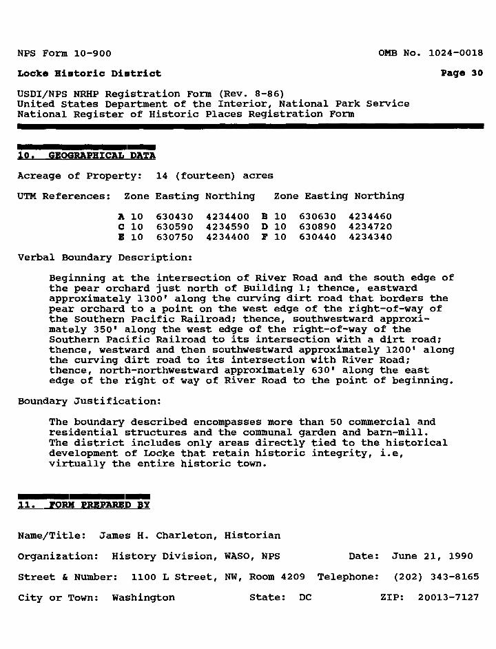
Acreage of Property: 14 (fourteen) acres
UTM References: Zone Easting Northing Zone Easting Northing
A 10 630430 4234400 B 10 630630 4234460C 10 630590 4234590 D 10 630890 4234720E 10 630750 4234400 F 10 630440 4234340
Verbal Boundary Description:
Beginning at the intersection of River Road and the south edge of the pear orchard just north of Building 1; thence, eastward approximately 1300' along the curving dirt road that borders the pear orchard to a point on the west edge of the right-of-way of the Southern Pacific Railroad; thence, southwestward approxi mately 350' along the west edge of the right-of-way of the Southern Pacific Railroad to its intersection with a dirt road; thence, westward and then southwestward approximately 1200' along the curving dirt road to its intersection with River Road; thence, north-northwestward approximately 630' along the east edge of the right of way of River Road to the point of beginning.
Boundary Justification:
The boundary described encompasses more than 50 commercial and residential structures and the communal garden and barn-mill. The district includes only areas directly tied to the historical development of Locke that retain historic integrity, i.e, virtually the entire historic town.
11. FORM PREPARED BY
Name/Title: James H. Charleton, Historian
Organization: History Division, WASO, NFS Date: June 21, 1990
Street & Number: 1100 L Street, NW, Room 4209 Telephone: (202) 343-8165
City or Town: Washington State: DC ZIP: 20013-7127
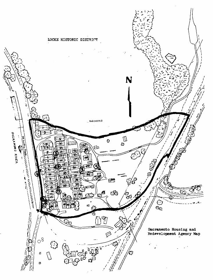
LOCKE HISTORIC DISTRICT
Sacramento Housing and Redevelopment Agency Map

WEST ELEVATION - RIVER ROAD
UMtMATM SHUT MIT At UMMATtl IMltT IMTM. Tin IMtlt MfTM.
. r-. n
•LLfVMT »¥«• BOM «T MlLf*T tTM TMMTMC
EAST ELEVATION - MAIN STREET ic*ct ; »m-- r-o-• • «
roormatMO MAM
ifti mtiMfrm raormos MM MO MMI
**U.« VOOOM
COMMUTflB IMIET IKTM. COMUMTIO *HCfT HlfM.
D nnnnn
:"II i
mt^
ccr
itr*
TOW
N
OF
LOC
KE.
C
ALI
FOR
NIA
UJCOD
i!iIi
<K
if
SECTION B-B

—3 o
COVEHEQ WALK
ruDO* WOODWALLS. MAD CO WOOD BOARDS CtlLIMI* MADCD WOOD •OAMOS
in rttci rodnow oven ALLEYWAY ON LCPT isCUT AVAT ON TME SECOND flOOft TO 1MO* MltH WALL LOUVNES
iciLf 1/4- •!•-«• fri.M H.<.!.> , ..
FIRST FLOOR PLAN SECOND FLOOR PLAN


![USDI/NPS NRHP Registration FormCastle Ballroom Section 7 Page 2 St. Louis [Independent City], Missouri entirely covered in corrugated metal and stuccoed panels. Double metal doors](https://static.fdocuments.us/doc/165x107/5f05e3807e708231d41538ee/usdinps-nrhp-registration-form-castle-ballroom-section-7-page-2-st-louis-independent.jpg)