Location and Description of Transects for Ecological...
92
SUWANNEE R I V E R Area shown in figure 22 Area shown in figure 20 347 TK SN SH BC DIXIE COUNTY LEVY COUNTY Fowlers Bluff North Entrance South Entrance 347 SANDFLY CREEK BARNETT CREEK Turkey Island 349 SUWANNEE R I V E R Area shown in figure 22 Area shown in figure 20 347 TK SN SH BC DIXIE COUNTY LEVY COUNTY Fowlers Bluff North Entrance South Entrance 347 SANDFLY CREEK BARNETT CREEK Turkey Island 349 Location and Description of Transects for Ecological Studies in Floodplain Forests of the Lower Suwannee River, Florida U.S. Department of the Interior U.S. Geological Survey Prepared in cooperation with the Suwannee River Water Management District Open-File Report 01-410
-
Upload
truongkhanh -
Category
Documents
-
view
213 -
download
0
Transcript of Location and Description of Transects for Ecological...

SU
WANNEE
RIV
ER
Area shownin figure 22
Area shownin figure 20
347
TK
SN
SH
BC
DIXIE
COUNTY
LEVY
COUNTY
FowlersBluff
North Entrance
SouthEntrance
347
SANDFLY CREEK
BA
RN
ET
TC
RE
EK
TurkeyIsland
349SU
WANNEE
RIV
ER
Area shownin figure 22
Area shownin figure 20
347
TK
SN
SH
BC
DIXIE
COUNTY
LEVY
COUNTY
FowlersBluff
North Entrance
SouthEntrance
347
SANDFLY CREEK
BA
RN
ET
TC
RE
EK
TurkeyIsland
349
Location and Description of Transects forEcological Studies in Floodplain Forests of theLower Suwannee River, Florida
U.S. Department of the InteriorU.S. Geological Survey
Prepared in cooperation with theSuwannee River Water Management District
Open-File Report01-410

Report Documentation Page Form ApprovedOMB No. 0704-0188
Public reporting burden for the collection of information is estimated to average 1 hour per response, including the time for reviewing instructions, searching existing data sources, gathering andmaintaining the data needed, and completing and reviewing the collection of information. Send comments regarding this burden estimate or any other aspect of this collection of information,including suggestions for reducing this burden, to Washington Headquarters Services, Directorate for Information Operations and Reports, 1215 Jefferson Davis Highway, Suite 1204, ArlingtonVA 22202-4302. Respondents should be aware that notwithstanding any other provision of law, no person shall be subject to a penalty for failing to comply with a collection of information if itdoes not display a currently valid OMB control number.
1. REPORT DATE 2002
2. REPORT TYPE N/A
3. DATES COVERED -
4. TITLE AND SUBTITLE Location and Description of Transects for Ecological Studies inFloodplain Forests of the Lower Suwannee River, Florida
5a. CONTRACT NUMBER
5b. GRANT NUMBER
5c. PROGRAM ELEMENT NUMBER
6. AUTHOR(S) 5d. PROJECT NUMBER
5e. TASK NUMBER
5f. WORK UNIT NUMBER
7. PERFORMING ORGANIZATION NAME(S) AND ADDRESS(ES) U.S. Department of the Interior 1849 C. Street, NW Washington, DC 20240
8. PERFORMING ORGANIZATIONREPORT NUMBER
9. SPONSORING/MONITORING AGENCY NAME(S) AND ADDRESS(ES) 10. SPONSOR/MONITOR’S ACRONYM(S)
11. SPONSOR/MONITOR’S REPORT NUMBER(S)
12. DISTRIBUTION/AVAILABILITY STATEMENT Approved for public release, distribution unlimited
13. SUPPLEMENTARY NOTES The original document contains color images.
14. ABSTRACT
15. SUBJECT TERMS
16. SECURITY CLASSIFICATION OF: 17. LIMITATION OF ABSTRACT
SAR
18. NUMBEROF PAGES
91
19a. NAME OFRESPONSIBLE PERSON
a. REPORT unclassified
b. ABSTRACT unclassified
c. THIS PAGE unclassified
Standard Form 298 (Rev. 8-98) Prescribed by ANSI Std Z39-18
U.S. GEOLOGICAL SURVEYOpen File Report 01-410
Location and Description of Transects for Ecological Studies in Floodplain Forests of the Lower Suwannee River, Florida
By Lori J. Lewis, Helen M. Light, and Melanie R. Darst
Tallahassee, Florida2002
Prepared in cooperation with the Suwannee River Water Management District

Copies of this report can be purchased from:
U.S. Geological SurveyBranch of Information ServicesBox 25286Denver, CO 80225-0286888-ASK-USGS
The use of firm, trade, and brand names in this report is for identification purposes only and does not constitute endorsement by the U.S. Geological Survey.
For additional informationwrite to:
District ChiefU.S. Geological SurveySuite 3015227 N. Bronough StreetTallahassee, FL 32301
Additional information about water resources in Florida is available on the Internet at http://fl.water.usgs.gov
U.S. DEPARTMENT OF THE INTERIORGALE A. NORTON, Secretary
U.S. GEOLOGICAL SURVEYCHARLES G. GROAT, Director

Contents III
CONTENTS
Abstract.................................................................................................................................................................................. 1Introduction ........................................................................................................................................................................... 1
Purpose and Scope ....................................................................................................................................................... 2Background.................................................................................................................................................................. 3Acknowledgements...................................................................................................................................................... 3
Methods ................................................................................................................................................................................. 4Transect Information ............................................................................................................................................................. 7
Confluence (CF) .......................................................................................................................................................... 8Log Landing (LL) ........................................................................................................................................................ 10Falkenburry (FK) ......................................................................................................................................................... 14Manatee Springs (MS) ................................................................................................................................................. 16Keen and Keen Island (KN and KI)............................................................................................................................. 19Turkey Island (TK) ...................................................................................................................................................... 22Sandfly North (SN)...................................................................................................................................................... 25Sandfly Hammock (SH)............................................................................................................................................... 27Barnett Creek (BC) ...................................................................................................................................................... 28Lock (LK) .................................................................................................................................................................... 29Demory (DM) .............................................................................................................................................................. 32
References ............................................................................................................................................................................. 33
APPENDIXES:
Appendix 1. Canopy tree species and measurements and marker locations on transects in the lower Suwannee River floodplain, Florida............................................................................................................................................................. 37
Appendix 2. Conversion tables for determining the permanent marker numbers of all previous stake numbers recorded in original U.S. Geological Survey field notes ...................................................................................................................... 82
FIGURES
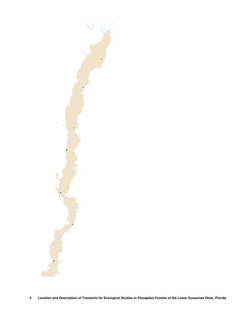
1-2. Maps showing:1. Drainage basin of the Suwannee River in Florida and Georgia ...................................................................... 22. Study area with locations of transects in the floodplain of the lower Suwannee River, Florida..................... 5
3-4. Photographs showing:3. Permanent marker with PVC sleeve used to mark transects in the lower Suwannee River floodplain,
Florida. ............................................................................................................................................................ 64. PVC pipe installed adjacent to marker used to mark transects in the lower Suwannee River floodplain,
Florida. ............................................................................................................................................................ 65-6. Maps showing:
5. CF transect and surrounding area in the lower Suwannee River floodplain, Florida. .................................... 96. CF transect with marker locations and access roads in the lower Suwannee River floodplain, Florida......... 9
7. Graph showing land-surface elevations and marker locations at CF transect in the lower Suwannee River floodplain, Florida. .................................................................................................................................................. 10
8-9. Maps showing:8. LL and FK transect locations with surrounding area in the lower Suwannee River floodplain, Florida........ 119. LL transect with marker locations and immediate vicinity in the lower Suwannee River floodplain, Florida. 12
10. Graph showing land-surface elevations and marker locations at LL transect in the lower Suwannee Riverfloodplain, Florida. .................................................................................................................................................. 13

IV Contents
11. Map showing FK transect with marker locations and access roads in the lower Suwannee River floodplain, Florida. .................................................................................................................................................. 14
12. Graph showing land-surface elevations and marker locations at FK transect in the lower Suwannee River floodplain, Florida. .................................................................................................................................................. 15
13-14. Maps showing13. MS, KN and KI transect locations and surrounding area in the lower Suwannee River floodplain, Florida. 1714. MS transect with marker locations and access roads in the lower Suwannee River floodplain, Florida. ...... 18
15. Graph showing land-surface elevations and marker locations at MS transect in the lower Suwannee River floodplain, Florida. .................................................................................................................................................. 19
16. Map showing KN and KI transects with marker locations and access roads in the lower Suwannee River floodplain, Florida. .................................................................................................................................................. 20
17-18. Graphs showing:17. Land-surface elevations and marker locations at KN transect in the lower Suwannee River Floodplain,
Florida............................................................................................................................................................. 2118. Land-surface elevations and marker locations at KI transect in the lower Suwannee River Floodplain,
Florida............................................................................................................................................................. 2119-20. Maps showing:
19. TK, SN, SH, and BC transect locations with surrounding area in the lower Suwannee River floodplain, Florida............................................................................................................................................................. 22
20. TK transect with marker locations and access roads in the lower Suwannee River floodplain, Florida........ 2321. Graph showing land-surface elevations and marker locations at TK transect in the lower Suwannee River
floodplain, Florida. .................................................................................................................................................. 2422. Map showing SN, SH, and BC transects with marker locations and access roads in the lower Suwannee
River floodplain, Florida. ........................................................................................................................................ 2523-25. Graphs showing:
23. Land-surface elevations and marker locations at SN transect in the lower Suwannee River floodplain, Florida............................................................................................................................................................. 26
24. Land-surface elevations and marker locations at SH transect in the lower Suwannee River floodplain, Florida............................................................................................................................................................. 27
25. Land-surface elevations and marker locations at BC transect in the lower Suwannee River floodplain, Florida............................................................................................................................................................. 28
26-27. Maps showing:26. LK and DM transect locations and surrounding area in the lower Suwannee River floodplain, Florida....... 2927. LK and DM transects with marker locations and access roads in the lower Suwannee River floodplain,
Florida............................................................................................................................................................. 3028-29. Graphs showing:
28. Land-surface elevations and marker locations at LK transect in the lower Suwannee River floodplain, Florida............................................................................................................................................................. 31
29. Land-surface elevations and marker locations at DM transect in the lower Suwannee River floodplain, Florida............................................................................................................................................................. 32
Contents V
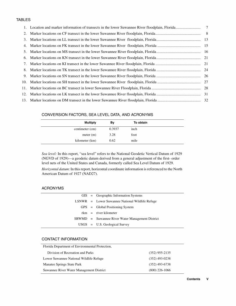
TABLES
1. Location and marker information of transects in the lower Suwannee River floodplain, Florida.......................... 7
2. Marker locations on CF transect in the lower Suwannee River floodplain, Florida............................................... 8
3. Marker locations on LL transect in the lower Suwannee River floodplain, Florida.............................................. 13
4. Marker locations on FK transect in the lower Suwannee River floodplain, Florida ............................................. 15
5. Marker locations on MS transect in the lower Suwannee River floodplain, Florida.............................................. 16
6. Marker locations on KN transect in the lower Suwannee River floodplain, Florida.............................................. 21
7. Marker locations on KI transect in the lower Suwannee River floodplain, Florida ............................................... 21
8. Marker locations on TK transect in the lower Suwannee River floodplain, Florida .............................................. 24
9. Marker locations on SN transect in the lower Suwannee River floodplain, Florida .............................................. 26
10. Marker locations on SH transect in the lower Suwannee River floodplain, Florida ............................................. 27
11. Marker locations on BC transect in lower Suwannee River Floodplain, Florida ................................................... 28
12. Marker locations on LK transect in the lower Suwannee River floodplain, Florida .............................................. 31
13. Marker locations on DM transect in the lower Suwannee River floodplain, Florida ............................................. 32
CONVERSION FACTORS, SEA LEVEL DATA, AND ACRONYMS
Sea level: In this report, “sea level” refers to the National Geodetic Vertical Datum of 1929 (NGVD of 1929)—a geodetic datum derived from a general adjustment of the first- order level nets of the United States and Canada, formerly called Sea Level Datum of 1929.
Horizontal datum: In this report, horizontal coordinate information is referenced to the North American Datum of 1927 (NAD27).
ACRONYMS
CONTACT INFORMATION
Multiply By To obtain
centimeter (cm) 0.3937 inch
meter (m) 3.28 foot
kilometer (km) 0.62 mile
GIS = Geographic Information Systems
LSNWR = Lower Suwannee National Wildlife Refuge
GPS = Global Positioning System
rkm = river kilometer
SRWMD = Suwannee River Water Management District
USGS = U.S. Geological Survey
Florida Department of Environmental Protection,
Division of Recreation and Parks (352) 955-2135
Lower Suwannee National Wildlife Refuge (352) 493-0238
Manatee Springs State Park (352) 493-6738
Suwannee River Water Management District (800) 226-1066

VI Contents

Location and Description of Transects for Ecological Studies in Floodplain Forests of the Lower Suwannee River, FloridaBy Lori J. Lewis, Helen M. Light and Melanie R. Darst
Abstract
Twelve transects were established in floodplain forests along the lower Suwannee River, Florida, as the principal data collection sites for a comprehensive study conducted by the U.S. Geological Survey and the Suwannee River Water Management District from 1996 to 2001. Data collected along the 12 transects included hydrologic conditions, land-surface elevations, soils, and vegetation of floodplain forests in relation to river flow. Transect locations are marked in the field with permanent markers at approximately 30 meter intervals.
Detailed descriptions of the 12 transects and their locations are provided so that they can be used for future ecological studies. Descriptions of the transects include contact information necessary for access to the property on which the transects are located, maps showing transect locations and routes from the nearest city or major road, small scale maps of each transect show-ing marker locations, latitude and longitude of each marker, compass bearings of each transect line and graphs showing land-surface elevations of the transect with marker locations.
Abstract
Twelve transects were established in floodplain forests along the lower Suwannee River, Florida, as the principal data collection sites for a comprehensive study conducted by the U.S. Geological Survey and the Suwannee River Water Management District from 1996 to 2001. Data collected along the 12 transects included hydrologic conditions, land-surface elevations, soils, and vegetation of floodplain forests in relation to river flow. Transect locations are marked in the field with permanent markers at approximately 30 meter intervals.
Detailed descriptions of the 12 transects and their locations are provided so that they can be used for future ecological studies. Descriptions of the transects include contact information necessary for access to the property on which the transects are located, maps showing transect locations and routes from the nearest city or major road, small scale maps of each transect showing marker locations, latitude and longitude of each marker, compass bearings of each transect line and graphs showing land-surface elevations of the transect with marker locations.
INTRODUCTION
This report is part of a comprehensive study of floodplain forests along the lower Suwannee River, Florida, conducted by the U.S. Geological Survey (USGS) in cooperation with the Suwannee River Water Management District (SRWMD) from 1996 to 2001. The purpose of the study was to help determine water needs for
maintaining healthy wetland eco-systems in the lower Suwannee River basin to assist the SRWMD in the establishment of minimum flows and levels for the river.
Data collected along twelve study transects included hydro-logic conditions, land-surface ele-vations, soils, and vegetation of floodplain forests in relation to
river flow (Light and others, in press; Darst and others, 2002). Locations and descriptions of the transects are presented to enable others to use these transects for future wetland studies such as long-term monitoring, land management studies, or interdisciplinary studies that could build on the information that has already been collected.
Introduction 1

Purpose and Scope
The objective of this report is to document the location and description of twelve permanently
marked transects in the forested floodplain of the lower Suwannee River to allow recovery of these transects for future studies. The study area for this project was the
forested floodplain of the Suwan-nee River from the confluence at the Santa Fe River to the down-stream limit of forests near the Gulf of Mexico (fig. 1).
Albany
G E O R G I A
F L O R I D A
Tallahassee
G u l fo f
M e x i c o
At
la
nt
ic
Oc
ea
nJacksonville
30 KILOMETERS
30 MILES
0 20
0 20
Gainesville
LakeCity
84°
32°
31°
30°
29°
83° 82°
Su
wannee
FeRiver
Satn a
Withla
cooch
ee
River
Ala
pha
aR
iver
River
Valdosta
CedarKey
EXPLANATION
GA
SUWANNEE RIVER DRAINAGE BASIN
STUDY AREA
OKEFENOKEE SWAMP
FLALocation
map
Areas shownin figure 2
Base from U.S. Geological Survey digital data, 1972Albers Equal-Area Conic Projection,Standard parallels 29 30 and 45 30 , central meridian -83 00° ° °′ ′ ′
Figure 1. Drainage basin of the Suwannee River in Florida and Georgia.
2 Location and Description of Transects for Ecological Studies in Floodplain Forests of the Lower Suwannee River, Florida

Background
The principal sites of data collection for a comprehensive wet-lands study were 12 belt transects established in the lower Suwannee River floodplain (fig. 2). A belt transect is a long, narrow rectangu-lar sampling area oriented along a centerline with a width of a few meters on one or both sides of the line.
In the comprehensive wet-land study, 14 forest types were defined from vegetative sampling and aerial photographic signatures at the transects. Extensive vegeta-tive, topographic, hydrologic and soils data collected on the transects were described and analyzed by forest type in a report by Light and others (in press). Ground cover veg-etation data was described by forest type in Darst and others, 2002. GIS
coverages of a forest map and the transect locations can be obtained from SRWMD or USGS files.
Specific transect data that is available for use by future research-ers is briefly described in the fol-lowing paragraphs. In the remainder of this background section, all appendix, table, and figure numbers refer to data pre-sented in the comprehensive report by Light and others (in press).
The specific location of the forest types at each transect are illustrated along with land-surface elevations of the transects and long-term hydrologic conditions in the Suwannee River in figure 15. The median elevations of the forest types at each transect (app. II) were compared to daily high stage at
each transect in the tidal portion of the Suwannee River in figure 16.
Water level measurements were made in the river and in flood-plain water bodies at the transects (app. III). Salinity of ponds and tidal creeks at selected lower tidal transects is described in appendix IV and figure 20.
Soil profiles were described at each transect at boring locations selected to represent various topo-graphic features and tree communi-ties (table 9, fig. 22 and app. V). Soil moisture observations were made at regular intervals along each transect line (app III). The amount of continuously saturated soils for the forest types at each transect is reported in table 10. Soil conduc-tivity measured at transects in the lower tidal portion of the river was reported in table 11 and figure 23.
Acknowledgements
The authors are grateful to USGS employees Darlene Blum, Warren Carmichael, Gary Mahon, Rich Marella, Terry Petrosky, Agustin Sepulveda, and Jim Tomberlin for their help in the installation of 170 markers in the floodplain.
The authors would like to thank John Good and Rob Mattson, SRWMD for technical reviews, and the following USGS employees: Jerilyn Collins, Gary Mahon, Jane Eggleston and Teresa Embry for tech-nical and editorial reviews; Agustin Sepulveda for geographic information systems (GIS) assistance; Ron Spencer and Jim Tomberlin for assistance with graphics; and Pat Mixson for layout.
Access to study sites was received from Ken Litzenberger, Lower Suwannee National Wildlife Refuge (LSNWR); Susie Hetrick, Florida Department of Parks and Recreation; Sally Lieb, Manatee Springs State Park; and Stephen Riggs, private landowner.
Introduction 3
26
27ALT
98
19
LAFAYETTE
DIXIE
LEVY
GILCHRIST
29°30′
29°35′
29°45′
83°00′
29°40′
82°55′
29°50′
Base from U.S. Geological Survey digital data, 1972Albers Equal-Area Conic Projection,Standard parallels 29 30 and 45 30 , central meridian -83 00° ° °′ ′ ′
ManateeSprings
OldTown
Wannee
Fanning Springs
Suw
anne
e R
iver
70
40
50
60
80
90
100
MS
FK
LL
CF
4 MILES
0
0 2
2 4 KILOMETERS
60
STUDY AREA
TRANSECT
DISTANCE FROM RIVER MOUTH In kilometers−
FK
EXPLANATION
Figure 2. Study area with locations of transects in the floodplain of the lower Suwannee River, Florida.
METHODS
Data collection efforts in the comprehensive study began in 1996 with the marking of transect lines with wooden stakes at approximately 30 meter intervals. The stakes had begun to show signs of deterioration by the end of the study period. The sites were revisited in 2001 and the wooden stakes replaced with ½-inch galvanized pipes labeled with aluminum tags for identifica-tion. They were installed so that approximately 18 inches of pipe was visible above the ground. For additional visibility, PVC pipes were installed around the galvanized pipe as a sleeve (fig. 3), or next to the galvanized pipe when conditions pre-vented sleeve-type installation (fig. 4).
Stainless steel rods (9/16-inch diameter) were installed at each transect endpoint to serve as backup reference points in case the visible perma-nent markers are damaged or destroyed by flood, fire, or vandalism. These rods were four feet in length and were driven to ground surface level so their location would be recoverable by use of a metal detector. Once the transect endpoint is found, the other transect marker locations can be reconstructed using compass bearings and mea-sured distances, with latitude and longitude of marker locations as an additional guide.
The map position of each transect marker was obtained from the GIS coverage of the transects. Latitudes and longitudes were deter-mined using an ARC macro language program that converts map units to geographic locations.
4 Location and Description of Transects for Ecological Studies in F
loodplain Forests of the Lower Suwannee River, Florida
98
DIXIE
LEVY
FowlersBluff
Suwannee
Gulf of M
exico
Suw
anne
e Ri
ver
SuwanneeSound
10
20
30
Wadley PassPass
Gophe
r Rive
r
East Pass
Allig
ator Pass
SandflyCreek
BC
SH
SN
KNKI
TK
DMLK
West
29°25′
29°20′
83°10′ 83°00′83°05′
0 2 4 MILES
0 2 4 KILOMETERS
Base from U.S. Geological Survey digital data, 1972Albers Equal-Area Conic Projection,Standard parallels 29 30 and 45 30 , central meridian -83 00° ° °′ ′ ′
Figure 2. Study area with locations of transects in the floodplain of the lower Suwannee River, Florida. (Continued)
Methods 5
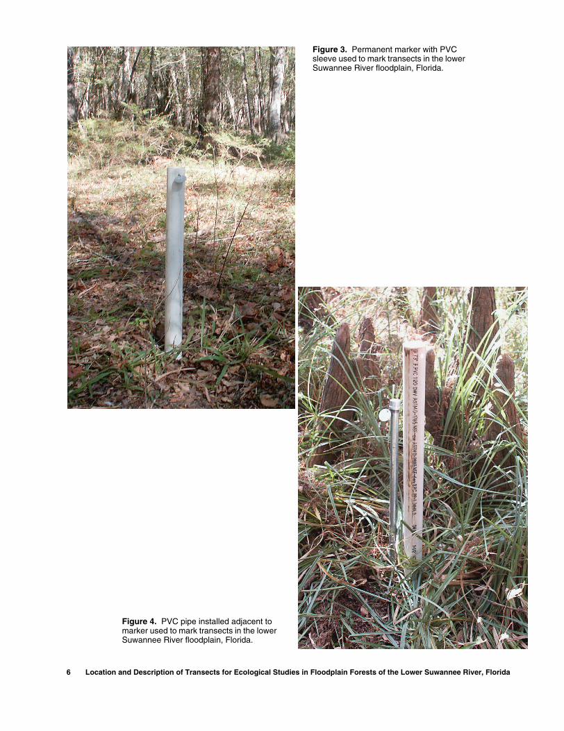
Figure 3. Permanent marker with PVC sleeve used to mark transects in the lower Suwannee River floodplain, Florida.
Figure 4. PVC pipe installed adjacent to marker used to mark transects in the lower Suwannee River floodplain, Florida.
6 Location and Description of Transects for Ecological Studies in Floodplain Forests of the Lower Suwannee River, Florida

TRANSECT INFORMATION
Descriptions of the transects are presented in downstream order. Directions by road are described using distances in miles; all other units in this report are metric. Basic data for the transects are included in table 1. Transect locations along the river are indicated in river kilo-meters (rkm), a measurement of stream distance beginning with 0 at the mouth of the river at latitude 29° 17′ 19.2″ and longitude 83° 9′ 51.8″.
Transects were named after the tract of land on which they were located or after a nearby creek or point of interest. Transects varied in length from 53.2 to 1,003.7 m and were 10 to 13 m wide when less than 400 m long and usually 5 m wide when longer.
Transects are located prima-rily on public lands with at least
one end of the transect accessible by boat or car. Permission from cur-rent land managers is needed to obtain access to these properties. The necessary contact information for property access is provided for each transect.
Maps showing the transect location and route from nearest city or major road are provided. In this report, U.S. and State highways are classified as primary roads, county roads and other paved streets are described as light duty roads, and dirt roads or trails are classified as unimproved roads. GIS coverage maps of each transect showing marker locations and numbers are also provided. Latitude and longi-tude of each marker are listed in an associated table.
Graphs showing land-sur-face elevations with marker loca-tions are provided for each transect.
Estimated elevations beyond the transect endpoints or between two segments of a transect are included to show the topographic features of the immediate area. The scales of the elevation graphs have been maximized for each transect for easier viewing of the marker num-bers and their locations; therefore, they cannot be used for comparing elevations of different transects. Elevation graphs of all the transects at the same scale are presented in figure 15 of Light and others, in press.
Canopy vegetation data with marker locations is presented for each transect in appendix 1. This information can be used not only as an additional guide for locating markers, but also as baseline data for future vegetative sampling efforts.
Table 1. Location and marker information of transects in the lower Suwannee Riverfloodplain, Florida
[rkm, river kilometers; m, meters]
Transect name Abbreviated
transect nameLocation,
in rkm
Length of transect,
in m
Number of markers
Range of marker
numbers
Confluence CF 104.3 441.0 21 1-22
Log Landing LL 77.6 921.2 30 22-51, 2001
1This marker is not on the transect line; it marks a verification plot near the transect
Falkenburry FK 64.4 362.6 15 52-66
Manatee Springs MS 42.5 1009.0 28 67-94
Keen KN 31.2 734.1 27 95-121
Keen Island KI 31.2 100.0 4 122-125
Turkey Island TK 19.8 411.9 15 126-140
Sandfly North SN 13.0 88.3 5 141-145
Sandfly Hammock SH 12.6 151.0 6 146-151
Barnett Creek BC 11.3 215.6 8 152-159
Lock LK 5.1 145.5 6 160-165
Demory DM 4.8 53.2 4 166-169
Transect Information 7

CF transect is located on land owned by the SRWMD. A locked gate restricts motor vehicle access to the roads on this property. Con-tact the SRWMD land manager in Live Oak, Florida at (800) 226-1066 for permission to access these lands.
CF transect is in eastern Lafayette County, approximately 1.6 kilometers downstream of the confluence of the Santa Fe River with the Suwannee River. To reach this transect from Branford, Flor-ida, travel 1.9 miles west on US Highway 27, then 4.3 miles south on State Highway 349 to County Road 138. Go east on County Road
Confluence (CF)
8 Location and Description of Transect
138 and follow this road to the Hatchbend boat ramp using the route highlighted in figure 5. Turn right on the last dirt road before the boat ramp. Turn left at the T-inter-section, travel approximately 1.5 miles and make another left turn. The SRWMD sign and locked gate are less than 0.1 mile down this drive. Once inside the gate, turn left. The roads on this property are very sandy and under certain condi-tions require the use of a four-wheel drive vehicle. Go approximately ¼ of a mile, following the 90° turn to the right, and then look for a smaller trail to the right. The west-ern portion of the transect is acces-
s for Ecological Studies in Floodplain Forests
sible from this trail. To reach the eastern portion of the transect con-tinue past this trail for another 0.5 mile until the road makes a 90° turn to the right.
CF transect is comprised of two segments (fig. 6), the west seg-ment (markers 1-7) and the east segment (markers 8-21). The west segment is 128.3 m in length and has a compass bearing of approxi-mately 80° from marker number 1. The east segment is 312.7 m long and has a compass bearing of 107° from marker 8. The latitude and longitude of each marker on the transect line are listed in table 2.
Table 2. Marker locations on CF transect in the lower Suwannee Riverfloodplain, Florida
Marker number
Distance from beginning of
segment
Distance from previous marker
Latitude Longitude
West Segment
1 0.0 - 29º 52′ 24.9″ 82º 53′ 14.7″2 20.1 20.1 29º 52′ 25.0″ 82º 53′ 14.0″3 44.6 24.5 29º 52′ 25.1″ 82º 53′ 13.1″4 68.3 23.7 29º 52′ 25.2″ 82º 53′ 12.2″5 88.6 20.3 29º 52′ 25.3″ 82º 53′ 11.4″6 115.5 26.9 29º 52′ 25.5″ 82º 53′ 10.4″7 128.3 12.8 29º 52′ 25.5″ 82º 53′ 10.0″
East Segment
8 0.0 - 29º 52′ 31.6″ 82º 52′ 47.9″9 22.1 22.1 29º 52′ 31.4″ 82º 52′ 47.1″10 53.9 31.8 29º 52′ 31.2″ 82º 52′ 46.0″11 79.9 26.0 29º 52′ 31.0″ 82º 52′ 45.0″12 106.8 26.9 29º 52′ 30.7″ 82º 52′ 44.1″13 129.4 22.6 29º 52′ 30.5″ 82º 52′ 43.3″14 158.7 29.3 29º 52′ 30.2″ 82º 52′ 42.2″15 187.8 29.1 29º 52′ 29.9″ 82º 52′ 41.2″16 216.3 28.5 29º 52′ 29.7″ 82º 52′ 40.2″17 235.2 18.9 29º 52′ 29.5″ 82º 52′ 39.5″18 256.7 21.5 29º 52′ 29.3″ 82º 52′ 38.7″19 286.1 29.4 29º 52′ 29.0″ 82º 52′ 37.7″20 300.8 14.7 29º 52′ 28.9″ 82º 52′ 37.2″21 310.7 9.9 29º 52′ 28.8″ 82º 52′ 36.8″
of the Lower Suwannee River, Florida

LA
FAY
ET
TE
CO
Markers 1-7
Markers 8-21
Suw
anne
e R
iver
82°53′15″ 82°53′ 82°52′45″
29°53′30″
29°53′25″
EXPLANATIONTRANSECT-Points indicate
marker locationsLOCKED GATE-Maintained
by SRWMDINDICATES DIRECTION OF
INCREASING MARKERNUMBERS
UNIMPROVED ROADSROUTE TO TRANSECT
GIL
CH
RIS
T C
O
0
0
0.1 0.2 KILOMETERS
0.1 0.2 MILES
82°56′
29°56′
29°52′
82°52′
349
27
247
CF
Area shownin figure 6
Branford
ToOld Town
HatchbendBoat Ramp
SAN
TAF
E
RIV
ER
S
I
U
WANNEE
RV
ER
SUWANNEE
COUNTY
LAFAYETTE
COUNTY
EXPLANATION
CF TRANSECT Location and
name
UNIMPROVED ROAD
LIGHT DUTY ROAD
PRIMARY ROAD
ROUTE TO TRANSECT
−
0
1 MILE0
1 KILOMETER
138
129
GILCHRIST
COUNTY
Figure 5. CF transect and surrounding area in the lower Suwannee River floodplain, Florida.
Figure 6. CF transect with marker locations and access roads in the lower Suwannee River floodplain, Florida.
Transect Information 9
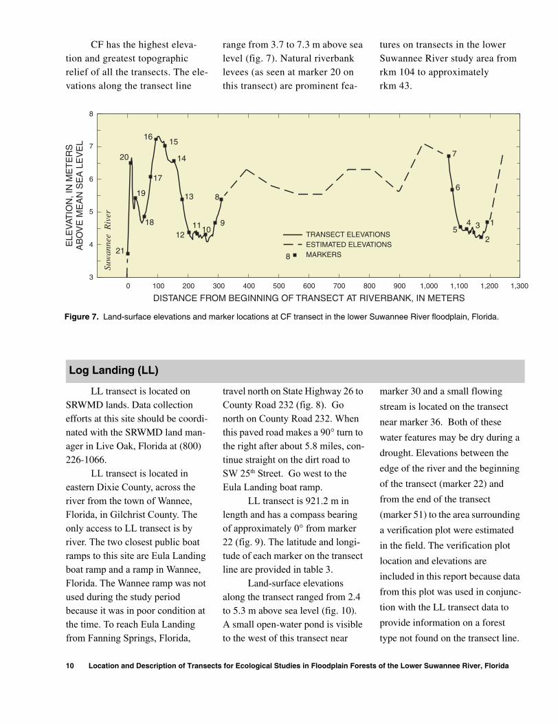
CF has the highest eleva-tion and greatest topographic relief of all the transects. The ele-vations along the transect line
range from 3.7 to 7.3 m above sea level (fig. 7). Natural riverbank levees (as seen at marker 20 on this transect) are prominent fea-
tures on transects in the lower Suwannee River study area from rkm 104 to approximately rkm 43.
LL transect is located on SRWMD lands. Data collection efforts at this site should be coordi-nated with the SRWMD land man-ager in Live Oak, Florida at (800) 226-1066.
LL transect is located in eastern Dixie County, across the river from the town of Wannee, Florida, in Gilchrist County. The only access to LL transect is by river. The two closest public boat ramps to this site are Eula Landing boat ramp and a ramp in Wannee, Florida. The Wannee ramp was not used during the study period because it was in poor condition at the time. To reach Eula Landing from Fanning Springs, Florida,
travel north on State Highway 26 to County Road 232 (fig. 8). Go north on County Road 232. When this paved road makes a 90° turn to the right after about 5.8 miles, con-tinue straight on the dirt road to SW 25th Street. Go west to the Eula Landing boat ramp.
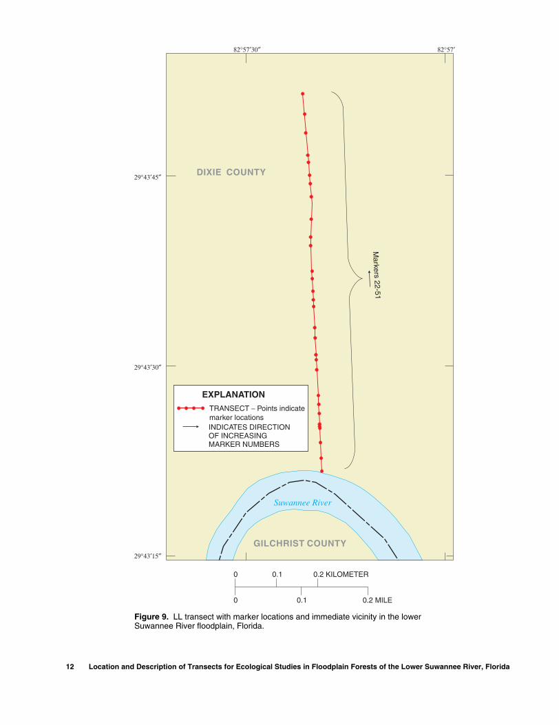
LL transect is 921.2 m in length and has a compass bearing of approximately 0° from marker 22 (fig. 9). The latitude and longi-tude of each marker on the transect line are provided in table 3.
Land-surface elevations along the transect ranged from 2.4 to 5.3 m above sea level (fig. 10). A small open-water pond is visible to the west of this transect near
marker 30 and a small flowing
stream is located on the transect
near marker 36. Both of these
water features may be dry during a
drought. Elevations between the
edge of the river and the beginning
of the transect (marker 22) and
from the end of the transect
(marker 51) to the area surrounding
a verification plot were estimated
in the field. The verification plot
location and elevations are
included in this report because data
from this plot was used in conjunc-
tion with the LL transect data to
provide information on a forest
type not found on the transect line.
TRANSECT ELEVATIONSESTIMATED ELEVATIONSMARKERS8
21
16
12
20
19
18
17
13
11109
8
1
2
345
6
7
15
14
0 100 200 300 400 500 600 700 800 900 1,000 1,100 1,200 1,300
DISTANCE FROM BEGINNING OF TRANSECT AT RIVERBANK, IN METERS
3
4
5
6
7
8
ELE
VAT
ION
, IN
ME
TE
RS
AB
OV
E M
EA
N S
EA
LE
VE
L
Suw
anne
e R
iver
Figure 7. Land-surface elevations and marker locations at CF transect in the lower Suwannee River floodplain, Florida.
Log Landing (LL)
10 Location and Description of Transects for Ecological Studies in Floodplain Forests of the Lower Suwannee River, Florida

83°00′
29°40′
82°55′
29°35′40″
EXPLANATION
FK TRANSECT-Locationand name
UNIMPROVED ROADLIGHT DUTY ROADPRIMARY ROAD
SUW
ANNEE
RIV
ER
Purvis LandingBoat Ramp
Area shownin figure 11
Area shownin figure 9
LL
FK
ALT27
1998
Purvis Landing Road
SW 25th Street
26
Eula LandingBoat Ramp
FanningSprings
OldTown
DIXIECOUNTY
GILCHRISTCOUNTY
LEVYCOUNTY
ToBranford Wannee
Boat Ramp
232 341349
232
349
ROUTE TO TRANSECT
1 2 MILES
1 2 KILOMETERS0
0
Figure 8. LL and FK transect locations with surrounding area in the lower Suwannee River floodplain, Florida.
Transect Information 11
12 Location and Description of Transects for Ecological Studies in Floodplain Forests of the Lower Suwannee River, Florida
0.1 0.2 KILOMETER
0
0
0.1 0.2 MILE
TRANSECT Points indicatemarker locations
−
INDICATES DIRECTIONOF INCREASINGMARKER NUMBERS
EXPLANATION
GILCHRIST COUNTY
DIXIE COUNTY
Suwannee River
Markers 22-51
82°57′82°57′30″
29°43′45″
29°43′30″
29°43′15″
Figure 9. LL transect with marker locations and immediate vicinity in the lower Suwannee River floodplain, Florida.
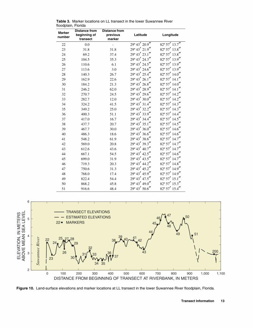
Table 3. Marker locations on LL transect in the lower Suwannee River floodplain, Florida
Marker number
Distance from beginning of
transect
Distance from previous marker
Latitude Longitude
22 0.0 - 29º 43′ 20.9″ 82º 57′ 13.7″23 31.8 31.8 29º 43′ 21.9″ 82º 57′ 13.8″24 69.2 37.4 29º 43′ 23.1″ 82º 57′ 13.8″25 104.5 35.3 29º 43′ 24.3″ 82º 57′ 13.9″26 110.6 6.1 29º 43′ 24.5″ 82º 57′ 13.9″27 113.6 3.0 29º 43′ 24.6″ 82º 57′ 13.9″28 140.3 26.7 29º 43′ 25.4″ 82º 57′ 14.0″29 162.9 22.6 29º 43′ 26.1″ 82º 57′ 14.1″30 184.2 21.3 29º 43′ 26.8″ 82º 57′ 14.0″31 246.2 62.0 29º 43′ 28.9″ 82º 57′ 14.1″32 270.7 24.5 29º 43′ 29.6″ 82º 57′ 14.2″33 282.7 12.0 29º 43′ 30.0″ 82º 57′ 14.2″34 324.2 41.5 29º 43′ 31.4″ 82º 57′ 14.3″35 349.2 25.0 29º 43′ 32.2″ 82º 57′ 14.3″36 400.3 51.1 29º 43′ 33.9″ 82º 57′ 14.4″37 417.0 16.7 29º 43′ 34.4″ 82º 57′ 14.5″38 437.7 20.7 29º 43′ 35.1″ 82º 57′ 14.5″39 467.7 30.0 29º 43′ 36.0″ 82º 57′ 14.6″40 486.3 18.6 29º 43′ 36.6″ 82º 57′ 14.6″41 548.2 61.9 29º 43′ 38.6″ 82º 57′ 14.7″42 569.0 20.8 29º 43′ 39.3″ 82º 57′ 14.7″43 612.6 43.6 29º 43′ 40.7″ 82º 57′ 14.7″44 667.1 54.5 29º 43′ 42.5″ 82º 57′ 14.6″45 699.0 31.9 29º 43′ 43.5″ 82º 57′ 14.7″46 719.3 20.3 29º 43′ 44.2″ 82º 57′ 14.8″47 750.6 31.3 29º 43′ 45.2″ 82º 57′ 14.9″48 768.0 17.4 29º 43′ 45.9″ 82º 57′ 14.9″49 822.4 54.4 29º 43′ 47.5″ 82º 57′ 15.1″50 868.2 45.8 29º 43′ 49.0″ 82º 57′ 15.3″51 916.6 48.4 29º 43′ 50.6″ 82º 57′ 15.4″
252224
26
23
2729
30
28
31
32
33
35
36
34
37
40 413942
43
38
4451
45
4746
48
49
50
200
TRANSECT ELEVATIONSESTIMATED ELEVATIONSMARKERS22
Suw
anne
e R
iver
0 100 200 300 400 500 600 700 800 900 1,000 1,100
DISTANCE FROM BEGINNING OF TRANSECT AT RIVERBANK, IN METERS
ELE
VAT
ION
, IN
ME
TE
RS
AB
OV
E M
EA
N S
EA
LE
VE
L
2
3
4
5
6
Figure 10. Land-surface elevations and marker locations at LL transect in the lower Suwannee River floodplain, Florida.
Transect Information 13
82°58′ 82°57′30″
Markers 52-58
GIL
CH
RIS
T C
OU
NT
Y
DIX
IE C
OU
NT
Y
Suwannee
River
Markers 59-66
Purvis Landing Road
Purvis LandingBoat Ramp
0 0.2 0.4 KILOMETER
0 0.2 0.4 MILE
EXPLANATION
TRANSECT oints indicate marker locations—P
UNIMPROVED ROADS
LIGHT DUTY ROADS
INDICATES DIRECTION OF INCREASINGMARKER NUMBERS
ROUTE TO TRANSECT
ations and access roads in the lower Suwannee River floodplain, Florida.
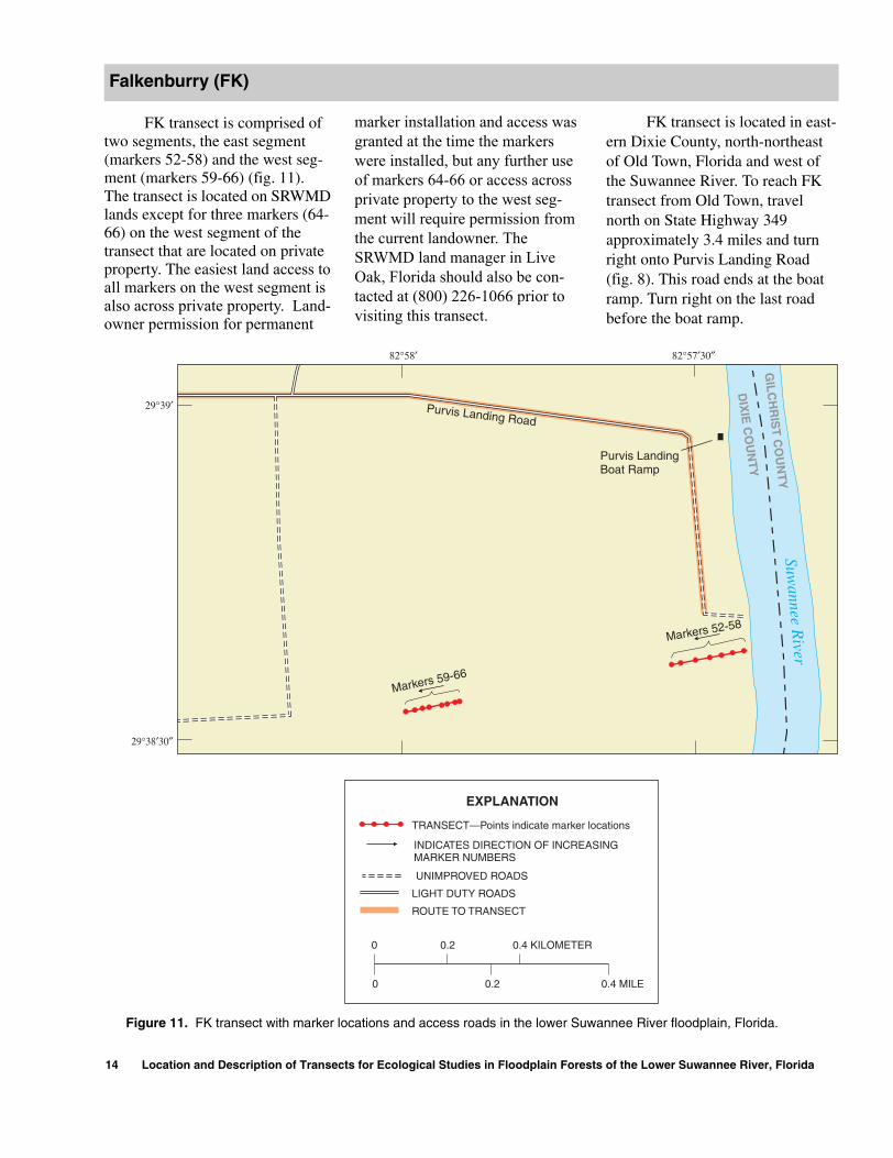
FK transect is comprised of two segments, the east segment (markers 52-58) and the west seg-ment (markers 59-66) (fig. 11). The transect is located on SRWMD lands except for three markers (64-66) on the west segment of the transect that are located on private property. The easiest land access to all markers on the west segment is also across private property. Land-owner permission for permanent
Falkenburry (FK)
29°39′
29°38′30″
Figure 11. FK transect with marker loc
14 Location and Description of Transec
marker installation and access was granted at the time the markers were installed, but any further use of markers 64-66 or access across private property to the west seg-ment will require permission from the current landowner. The SRWMD land manager in Live Oak, Florida should also be con-tacted at (800) 226-1066 prior to visiting this transect.
ts for Ecological Studies in Floodplain Forest
FK transect is located in east-ern Dixie County, north-northeast of Old Town, Florida and west of the Suwannee River. To reach FK transect from Old Town, travel north on State Highway 349 approximately 3.4 miles and turn right onto Purvis Landing Road (fig. 8). This road ends at the boat ramp. Turn right on the last road before the boat ramp.
s of the Lower Suwannee River, Florida
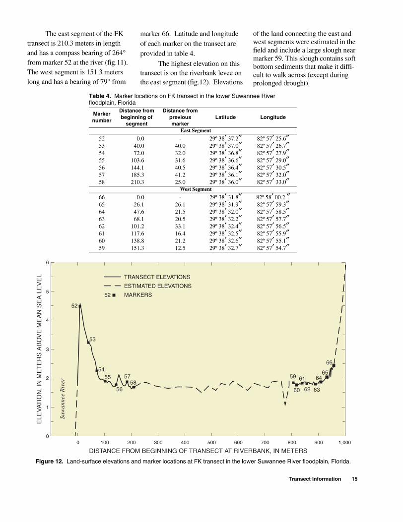
The east segment of the FK transect is 210.3 meters in length and has a compass bearing of 264° from marker 52 at the river (fig.11). The west segment is 151.3 meters long and has a bearing of 79° from
marker 66. Latitude and longitude of each marker on the transect are provided in table 4.
The highest elevation on this transect is on the riverbank levee on the east segment (fig.12). Elevations
of the land connecting the east and west segments were estimated in the field and include a large slough near marker 59. This slough contains soft bottom sediments that make it diffi-cult to walk across (except during prolonged drought).
Table 4. Marker locations on FK transect in the lower Suwannee River floodplain, Florida
Marker number
Distance from beginning of
segment
Distance from previous marker
Latitude Longitude
East Segment
52 0.0 - 29º 38′ 37.2″ 82º 57′ 25.6″53 40.0 40.0 29º 38′ 37.0″ 82º 57′ 26.7″54 72.0 32.0 29º 38′ 36.8″ 82º 57′ 27.9″55 103.6 31.6 29º 38′ 36.6″ 82º 57′ 29.0″56 144.1 40.5 29º 38′ 36.4″ 82º 57′ 30.5″57 185.3 41.2 29º 38′ 36.1″ 82º 57′ 32.0″58 210.3 25.0 29º 38′ 36.0″ 82º 57′ 33.0″
West Segment
66 0.0 - 29º 38′ 31.8″ 82º 58′ 00.2 ″65 26.1 26.1 29º 38′ 31.9″ 82º 57′ 59.3″64 47.6 21.5 29º 38′ 32.0″ 82º 57′ 58.5″63 68.1 20.5 29º 38′ 32.2″ 82º 57′ 57.7″62 101.2 33.1 29º 38′ 32.4″ 82º 57′ 56.5″61 117.6 16.4 29º 38′ 32.5″ 82º 57′ 55.9″60 138.8 21.2 29º 38′ 32.6″ 82º 57′ 55.1″59 151.3 12.5 29º 38′ 32.7″ 82º 57′ 54.7″
6
56
52
54
53
55 5758
62
66
6559
60
61
63
64
TRANSECT ELEVATIONS
ESTIMATED ELEVATIONS
MARKERS52
Suw
anne
e R
iver
0 100 200 300 400 500 600 700 800 900 1,000
DISTANCE FROM BEGINNING OF TRANSECT AT RIVERBANK, IN METERS
ELE
VAT
ION
, IN
ME
TE
RS
AB
OV
E M
EA
N S
EA
LE
VE
L
0
1
2
3
4
5
Figure 12. Land-surface elevations and marker locations at FK transect in the lower Suwannee River floodplain, Florida.
Transect Information 15

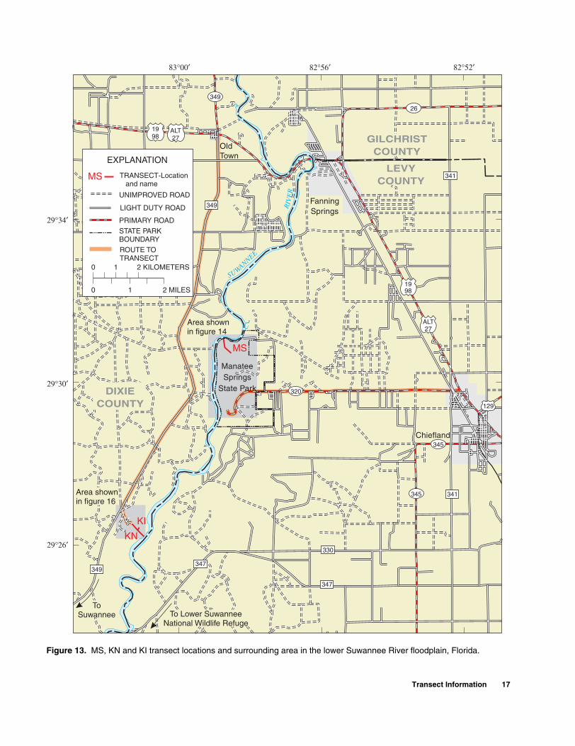
MS transect is located in Manatee Springs State Park. Con-tact the Park Manager at (352) 493-6738 in advance of field visits for coordination and arrangements. A research/collecting permit is needed to conduct a study in a Flor-ida state park or preserve. Permit applications are available from the Florida Department of Environ-mental Protection, Division of Rec-reation and Parks in Gainesville, Florida at (352) 955-2135.
Manatee Springs State Park is located in northwestern Levy County, Florida. To reach the park from Chiefland, Florida, go west on State Highway 320 directly to the
Manatee Springs (MS)
16 Location and Description of Transec
park entrance (fig. 13). The transect is located in the north end trail system; the trail entrance is the second road on the right after the park entrance (fig. 14). Although the trail system is open to foot and bicycle traffic during park hours, a locked gate restricts motor vehicle access. From the trail entrance, fol-low Scenic trail approximately 0.9 miles to a T-intersection then turn right on Clay trail. After a very short distance, turn left onto Hard-wood trail and follow this trail approximately 0.4 miles.
MS transect measures 1,009 meters in length and is the longest of the 12 transects. The
ts for Ecological Studies in Floodplain Forest
compass bearing of the transect line is 316.5° from marker 67 to marker 82, 338.5° from marker 82 to 83, and 353° from marker 83 to the transect endpoint at marker 94. The latitude and longitude of each marker are listed in table 5.
Land-surface elevations along the transect line are illus-trated in figure 15. Similar to CF transect, there is a second higher ridge on this transect immediately behind the riverbank levee. The swamps between markers 72-81 and 84-88 are continuously satu-rated and the ground is often “soupy”.
Table 5. Marker locations on MS transect in the lower Suwannee Riverfloodplain, Florida
Marker number
Distance from beginning of
transect
Distance from previous marker
Latitude Longitude
67 0.0 - 29º 30′ 37.1″ 82º 58′ 27.8″68 48.2 48.2 29º 30′ 38.2″ 82º 58′ 29.2″69 102.6 54.4 29º 30′ 39.4″ 82º 58′ 30.7″70 150.5 47.9 29º 30′ 40.4″ 82º 58′ 32.0″71 200.0 49.5 29º 30′ 41.5″ 82º 58′ 33.3″72 238.1 38.1 29º 30′ 42.3″ 82º 58′ 34.4″73 261.0 22.9 29º 30′ 42.8″ 82º 58′ 35.0″74 291.5 30.5 29º 30′ 43.5″ 82º 58′ 35.9″75 325.4 33.9 29º 30′ 44.2″ 82º 58′ 36.8″76 358.7 33.3 29º 30′ 44.9″ 82º 58′ 37.7″77 391.7 33.0 29º 30′ 45.6″ 82º 58′ 38.6″78 420.7 29.0 29º 30′ 46.3″ 82º 58′ 39.4″79 452.7 32.0 29º 30′ 47.0″ 82º 58′ 40.3″80 475.4 22.7 29º 30′ 47.5″ 82º 58′ 40.9″81 515.4 40.0 29º 30′ 48.3″ 82º 58′ 42.0″82 553.1 37.7 29º 30′ 49.2″ 82º 58′ 43.1″83 587.7 34.6 29º 30′ 50.2″ 82º 58′ 43.7″84 639.2 51.5 29º 30′ 51.8″ 82º 58′ 44.0″85 676.2 37.0 29º 30′ 53.0″ 82º 58′ 44.2″86 704.0 27.8 29º 30′ 53.9″ 82º 58′ 44.3″87 737.8 33.8 29º 30′ 55.0″ 82º 58′ 44.5″88 774.0 36.2 29º 30′ 56.1″ 82º 58′ 44.7″89 804.3 30.3 29º 30′ 57.1″ 82º 58′ 44.8″90 845.0 40.7 29º 30′ 58.4″ 82º 58′ 45.1″91 889.5 44.5 29º 30′ 59.9″ 82º 58′ 45.3″92 917.4 27.9 29º 31′ 00.8″ 82º 58′ 45.4″93 970.1 52.7 29º 31′ 02.5″ 82º 58′ 45.7″94 1003.7 33.6 29º 31′ 03.5″ 82º 58′ 45.9″
s of the Lower Suwannee River, Florida
SUWANNEE
RIV
ER
347
FanningSprings
OldTown
Chiefland
349
349
KN
MS
KI
349
ManateeSprings
State Park
Area shownin figure 16
Area shownin figure 14
320
26
129
ALT27
1998
345
ALT27
1998
345
ToSuwannee
29°26′
82°52′83°00′
29°34′
DIXIECOUNTY
LEVYCOUNTY
GILCHRISTCOUNTY
To Lower SuwanneeNational Wildlife Refuge
UNIMPROVED ROAD
LIGHT DUTY ROAD
PRIMARY ROAD
STATE PARKBOUNDARY
TRANSECT-Locationand name
MS
EXPLANATION
347
341
341
330
ROUTE TOTRANSECT
0
1 2 MILES0
1 2 KILOMETERS
82°56′
29°30′
Figure 13. MS, KN and KI transect locations and surrounding area in the lower Suwannee River floodplain, Florida.
Transect Information 17

Riv
erSu
wan
nee
Sc
ec
ni
Ho
ard
wo
dFork
ParkEntrance
Clay
Hornet
Loop
TRANSECT
PRIMARY ROAD
TRAIL
EXPLANATION
ROUTE TO TRANSECT
Markers 67-82
Markers83-94
320
LOCKED GATE
North EndTrail Entrance
0
0.4 MILE0
0.4 KILOMETER
Figure 14. MS transect with marker locations and access roads in the lower Suwannee River floodplain, Florida.
18 Location and Description of Transects for Ecological Studies in Floodplain Forests of the Lower Suwannee River, Florida

6768
6970
71
7273
74 75
76
7778
7980
81
82 83 8485 86 87
88
89
90
91
92
94
93
TRANSECT ELEVATIONS
ESTIMATED ELEVATIONS
MARKERS79
0 100 200 300 400 500 600 700 800 900 1,000 1,100
DISTANCE FROM BEGINNING OF TRANSECT AT UPLAND END, IN METERS
ELE
VAT
ION
, IN
ME
TE
RS
AB
OV
E M
EA
N S
EA
LE
VE
L
0
1
2
3
Suw
anne
e R
iver
Figure 15. Land-surface elevations and marker locations at MS transect in the lower Suwannee River floodplain, Florida.
d KI)
KN and KI transects are
located in the Lower Suwannee
National Wildlife Refuge
(LSNWR). Road access to this
transect is restricted by a locked
gate, therefore arrangements must
be made with the Refuge Manager
at (352) 493-0238 prior to field vis-
its. The LSNWR Headquarters are
located approximately 2 miles
south of Fowlers Bluff, Florida on
Highway 347.
KN and KI transects are
located in southeastern Dixie
County, west of the Suwannee
River. To reach these transects from
Old Town, Florida, go south on
Keen and Keen Island (KN an
County Road 349 (fig. 13). Travel
11.5 miles and turn left on the dirt
road with a yellow gate at the
entrance. Follow this road (fig. 16)
until it forks; continue straight
ahead (left fork) to a locked gate,
proceed to the split in the road, take
the right fork, then travel a short
distance and take the left fork. Fol-
low this road to the dead end.
KN transect is 734.1 m long
and has a compass bearing of 140°
from marker 95. The latitude and
longitude of each marker are listed
in table 6. KI is a 100 m transect
that lies nearly perpendicular to
KN. The beginning of KI is located
between KN markers 106 and 107
and this transect has a compass
bearing of 30° from marker 122.
The latitude and longitude of each
marker on this transect are listed in
table 7.
Land-surface elevations of
the transects are presented in fig-
ures 17 and 18. The lowest eleva-
tions on KN transect occur in a
marsh that lies between markers
120 and 121, and in a tidal creek
near marker 114. Soils on most of
the KN transect are continuously
saturated mucks; however the soils
on KI are usually dry and sandy.
Transect Information 19

83°01′30″ 83°01′
29°27′
29°26′30″
LEVY
CO
Markers 95-106
Markers 107-121
Mar
kers
122-
125
Suwan
nee R
iver
KN
KI
349
DIXIECOUNTY
INDICATES DIRECTION OF INCREASINGMARKER NUMBERS
LOCKED GATE
EXPLANATION
TRANSECT points indicate marker locations—
UNIMPROVED ROAD
LIGHT DUTY ROAD
ROUTE TO TRANSECT
0
0.2 KILOMETER
0.2 MILE
0
Figure 16. KN and KI transects with marker locations and access roads in the lower Suwannee River floodplain, Florida.
20 Location and Description of Transects for Ecological Studies in Floodplain Forests of the Lower Suwannee River, Florida

Table 6. Marker locations on KN transect in the lower Suwannee River floodplain, Florida
Marker number
Distance from
beginning of transect
Distance from
previous marker
Latitude Longitude
95 0.0 - 29º 26′ 28.5″ 83º 01′ 18.8″96 25.2 25.2 29º 26′ 27.9″ 83º 01′ 18.1″97 51.6 26.4 29º 26′ 27.3″ 83º 01′ 17.4″98 70.2 18.6 29º 26′ 26.9″ 83º 01′ 16.9″99 97.2 27.0 29º 26′ 26.3″ 83º 01′ 16.2″100 117.9 20.7 29º 26′ 25.8″ 83º 01′ 15.7″101 139.1 21.2 29º 26′ 25.3″ 83º 01′ 15.1″102 160.3 21.2 29º 26′ 24.8″ 83º 01′ 14.5″103 190.8 30.5 29º 26′ 24.1″ 83º 01′ 13.7″104 221.7 30.9 29º 26′ 23.4″ 83º 01′ 12.9″105 265.2 43.5 29º 26′ 22.4″ 83º 01′ 11.8″106 290.2 25.0 29º 26′ 21.9″ 83º 01′ 11.1″107 322.9 32.7 29º 26′ 21.1″ 83º 01′ 10.3″108 348.5 25.6 29º 26′ 20.5″ 83º 01′ 09.6″109 383.3 34.8 29º 26′ 19.7″ 83º 01′ 08.6″110 407.6 24.3 29º 26′ 19.2″ 83º 01′ 08.0″111 431.3 23.7 29º 26′ 18.7″ 83º 01′ 07.4″112 452.6 21.3 29º 26′ 18.2″ 83º 01′ 06.8″113 481.0 28.4 29º 26′ 17.5″ 83º 01′ 06.1″114 512.3 31.3 29º 26′ 16.8″ 83º 01′ 05.2″115 550.3 38.0 29º 26′ 15.9″ 83º 01′ 04.2″116 580.6 30.3 29º 26′ 15.2″ 83º 01′ 03.4″117 607.5 26.9 29º 26′ 14.6″ 83º 01′ 02.7″118 630.5 23.0 29º 26′ 14.1″ 83º 01′ 02.1″119 653.8 23.3 29º 26′ 13.6″ 83º 01′ 01.5″120 679.2 25.4 29º 26′ 13.0″ 83º 01′ 00.8″121 729.3 50.1 29º 26′ 11.9″ 83º 01′ 59.5″
Table 7. Marker locations on KI transect in the lower Suwannee River floodplain, Florida
Marker number
Distance from
beginning of transect
Distance from
previous marker
Latitude Longitude
122 0.0 - 29º 26′ 21.6″ 83º 01′ 10.5″123 36.9 36.9 29º 26′ 22.6″ 83º 01′ 09.8″124 74.0 37.1 29º 26′ 23.6″ 83º 01′ 09.1″125 100.0 26.0 29º 26′ 24.4″ 83º 01′ 08.6″
125
123
122
124
0 50 100 150
DISTANCE FROM BEGINNING OFTRANSECT, IN METERS
ELE
VAT
ION
, IN
ME
TE
RS
AB
OV
EM
EA
N S
EA
LE
VE
L
0
0.5
1.0
TRANSECT ELEVATIONS
MARKERS122
EXPLANATION
Figure 18. Land-surface elevations and marker locations at KI transect in the lower Suwannee River Floodplain, Florida.
KI Transectbegins here
TRANSECT ELEVATIONS
ESTIMATED ELEVATIONS
MARKERS121
Suw
anne
eR
iver
118
9596
979899
100101102103104
105
106107
109110111
112
113
114115
116117
119
120121 108
0 100 200 300 400 500 600 700 800
DISTANCE FROM BEGINNING OF TRANSECT AT RIVERBANK, IN METERS
ELE
VAT
ION
, IN
ME
TE
RS
AB
OV
E M
EA
N S
EA
LE
VE
L
0
0.5
1.0
1.5
2.0
Figure 17. Land-surface elevations and marker locations at KN transect in the lower Suwannee River Floodplain, Florida.
Transect Information 21
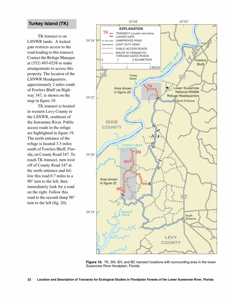
TK transect is on LSNWR lands. A locked gate restricts access to the road leading to this transect. Contact the Refuge Manager at (352) 493-0238 to make arrangements to access this property. The location of the LSNWR Headquarters, approximately 2 miles south of Fowlers Bluff on High-way 347, is shown on the map in figure 19.
TK transect is located in western Levy County in the LSNWR, southeast of the Suwannee River. Public access roads in the refuge are highlighted in figure 19. The north entrance of the refuge is located 3.3 miles south of Fowlers Bluff, Flor-ida, on County Road 347. To reach TK transect, turn west off of County Road 347 at the north entrance and fol-low this road 0.7 miles to a 90° turn to the left, then immediately look for a road on the right. Follow this road to the second sharp 90° turn to the left (fig. 20).
Turkey Island (TK)
22 Location and Description of T
SUWANNEE
RIVE
R
1
10
2 MILES0
2 KILOMETERS
29°24′
83°04′ 83°02′
29°22′
29°20′
29°18′
Area shownin figure 22
Area shownin figure 20
347
TK
SN
SH
BC
DIXIECOUNTY
LEVYCOUNTY
FowlersBluff
North Entrance
SouthEntrance
Lower SuwanneeNational Wildlife
Refuge Headquarters
EXPLANATIONTK TRANSECT-Location and name
LOCKED GATEUNIMPROVED ROAD
PUBLIC ACCESS ROADS
ROUTE TO TRANSECTS -THROUGH GATED ROADS
347349
SANDFLY CREEK
BARNETTCREEK
TurkeyIsland
LIGHT DUTY ROAD
Figure 19. TK, SN, SH, and BC transect locations with surrounding area in the lower Suwannee River floodplain, Florida.
ransects for Ecological Studies in Floodplain Forest
s of the Lower Suwannee River, Florida
Turkey Island
Suwannee Rive
r
Markers 126-140
EXPLANATION
TRANSECT—points indicate marker locations
UNIMPROVED ROADS
29°22′30″
29°22′15″
29°22′
83°03′30″ 83°03′15″ 83°03′
DIXIE CO.
LEVY CO.
INDICATES DIRECTION OF INCREASINGMARKER NUMBERS
ROUTE TO TRANSECT
LOCKED GATE
0
0
0.2 KILOMETERS
0.2 MILES
Figure 20. TK transect with marker locations and access roads in the lower Suwannee River floodplain, Florida.
Transect Information 23

TK is a 411.9-meter transect with a compass bearing of 320° from marker 126. Latitude and lon-gitude of each marker on the transect are listed in table 8.
Land-surface elevations of the transect line are provided in
figure 21. The peaks that appear on the transect are hummocks, mounds around the bases of trees elevated above the surrounding ground. Hummocks are present at nearly all transects but are most commonly exist on those in
the lower tidal portion of the river. The lowest elevation on this transect is a tidal creek, located between markers 135 and 136, approximately 290 meters from the beginning of the transect.
Table 8. Marker locations on TK transect in the lower Suwannee River floodplain,Florida
Marker number
Distance from beginning of
transect
Distance from previous marker
Latitude Longitude
126 0.0 - 29º 22′ 19.4″ 83º 03′ 25.7″127 29.6 29.6 29º 22′ 20.1″ 83º 03′ 26.5″128 54.6 25.0 29º 22′ 20.6″ 83º 03′ 27.1″129 84.3 29.7 29º 22′ 21.3″ 83º 03′ 27.9″130 110.5 26.2 29º 22′ 22.0″ 83º 03′ 28.5″131 140.4 29.9 29º 22′ 22.7″ 83º 03′ 29.3″132 173.1 32.7 29º 22′ 23.4″ 83º 03′ 30.1″133 205.9 32.8 29º 22′ 24.2″ 83º 03′ 31.0″134 241.4 35.5 29º 22′ 25.0″ 83º 03′ 31.9″135 271.0 29.6 29º 22′ 25.7″ 83º 03′ 32.7″136 305.8 34.8 29º 22′ 26.5″ 83º 03′ 33.6″137 333.0 27.2 29º 22′ 27.2″ 83º 03′ 34.3″138 361.1 28.1 29º 22′ 27.8″ 83º 03′ 35.0″139 392.2 31.1 29º 22′ 28.6″ 83º 03′ 35.8″140 411.9 19.7 29º 22′ 29.0″ 83º 03′ 36.3″
126
127 128
129
130
131 133 134 135
136
137
139
140
132 138
TRANSECT ELEVATIONS
ESTIMATED ELEVATIONS
MARKERS126
0 50 100 150 200 250 300 350 400 450
DISTANCE FROM BEGINNING OF TRANSECT AT UPLAND END, IN METERS
ELE
VAT
ION
, IN
ME
TE
RS
AB
OV
E M
EA
N S
EA
LE
VE
L
0
0.5
1.0
1.5
Suw
anne
e R
iver
Figure 21. Land-surface elevations and marker locations at TK transect in the lower Suwannee River floodplain, Florida.
24 Location and Description of Transects for Ecological Studies in Floodplain Forests of the Lower Suwannee River, Florida
83°04′30″ 83°04′00″
29°20′15″
83°04′15″
Y
CREEK EXPLANATIONTRANSECT oints indicate—P
Markers 146-151
Markers 1
41-145
Markers 152-159
SN
SH
BC
29°20′00″
29°19′45″
29°19′30″
29°19′15″
29°19′00″
29°18′45″
SAND
FL marker locations
UNIMPROVED ROADS
0
0.2 MILES0
0.2 KILOMETERS
INDICATES DIRECTION OFINCREASING MARKERNUMBERS
ROUTE TO TRANSECTS-THROUGH GATED ROADS
LOCKED GATE
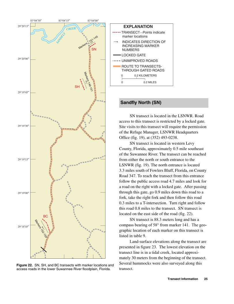
Figure 22. SN, SH, and BC transects with marker locations and access roads in the lower Suwannee River floodplain, Florida.
SN transect is located in the LSNWR. Road access to this transect is restricted by a locked gate. Site visits to this transect will require the permission of the Refuge Manager, LSNWR Headquarters Office (fig. 19), at (352) 493-0238.
SN transect is located in western Levy County, Florida, approximately 0.5 mile southeast of the Suwannee River. The transect can be reached from either the north or south entrance to the LSNWR (fig. 19). The north entrance is located 3.3 miles south of Fowlers Bluff, Florida, on County Road 347. To reach the transect from this entrance follow the public access road 4.7 miles and look for a road on the right with a locked gate. After passing through this gate, go 0.9 miles down this road to a fork, take the right fork and then follow this road 0.3 miles to a T-intersection. Turn right and follow this road 0.8 miles to the transect. SN transect is located on the east side of the road (fig. 22).
SN transect is 88.3 meters long and has a compass bearing of 58° from marker 141. The geo-graphic location of each marker on this transect is listed in table 9.
Land-surface elevations along the transect are presented in figure 23. The lowest elevation on the transect line is in a tidal creek, located approxi-mately 30 meters from the beginning of the transect. Several hummocks were also surveyed along this transect.
Sandfly North (SN)
Transect Information 25
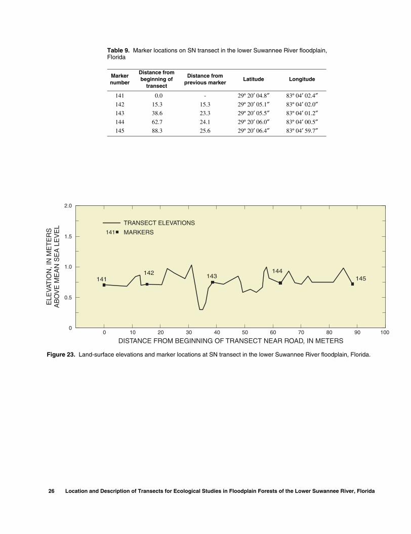
Table 9. Marker locations on SN transect in the lower Suwannee River floodplain,Florida
Marker number
Distance from beginning of
transect
Distance from previous marker
Latitude Longitude
141 0.0 - 29º 20′ 04.8″ 83º 04′ 02.4″142 15.3 15.3 29º 20′ 05.1″ 83º 04′ 02.0″143 38.6 23.3 29º 20′ 05.5″ 83º 04′ 01.2″144 62.7 24.1 29º 20′ 06.0″ 83º 04′ 00.5″145 88.3 25.6 29º 20′ 06.4″ 83º 04′ 59.7″
141142 143
144145
TRANSECT ELEVATIONS
MARKERS141
ELE
VAT
ION
, IN
ME
TE
RS
AB
OV
E M
EA
N S
EA
LE
VE
L
0 10 20 30 40 50 60 70 80 90 100
DISTANCE FROM BEGINNING OF TRANSECT NEAR ROAD, IN METERS
0
0.5
1.0
1.5
2.0
Figure 23. Land-surface elevations and marker locations at SN transect in the lower Suwannee River floodplain, Florida.
26 Location and Description of Transects for Ecological Studies in Floodplain Forests of the Lower Suwannee River, Florida
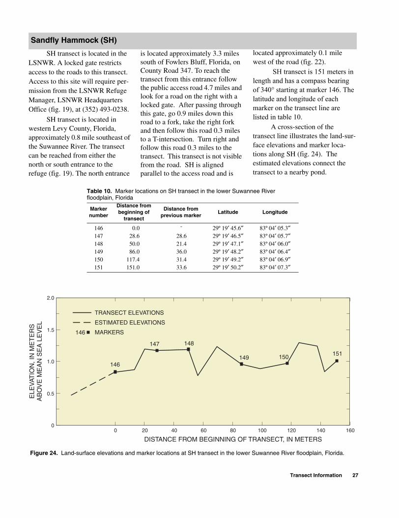
SH transect is located in the LSNWR. A locked gate restricts access to the roads to this transect. Access to this site will require per-mission from the LSNWR Refuge Manager, LSNWR Headquarters Office (fig. 19), at (352) 493-0238.
SH transect is located in western Levy County, Florida, approximately 0.8 mile southeast of the Suwannee River. The transect can be reached from either the north or south entrance to the refuge (fig. 19). The north entrance
Sandfly Hammock (SH)
is located approximately 3.3 miles south of Fowlers Bluff, Florida, on County Road 347. To reach the transect from this entrance follow the public access road 4.7 miles and look for a road on the right with a locked gate. After passing through this gate, go 0.9 miles down this road to a fork, take the right fork and then follow this road 0.3 miles to a T-intersection. Turn right and follow this road 0.3 miles to the transect. This transect is not visible from the road. SH is aligned parallel to the access road and is
located approximately 0.1 mile west of the road (fig. 22).
SH transect is 151 meters in length and has a compass bearing of 340° starting at marker 146. The latitude and longitude of each marker on the transect line are listed in table 10.
A cross-section of the transect line illustrates the land-sur-face elevations and marker loca-tions along SH (fig. 24). The estimated elevations connect the transect to a nearby pond.
Table 10. Marker locations on SH transect in the lower Suwannee River floodplain, Florida
Marker number
Distance from beginning of
transect
Distance from previous marker
Latitude Longitude
146 0.0 - 29º 19′ 45.6″ 83º 04′ 05.3″147 28.6 28.6 29º 19′ 46.5″ 83º 04′ 05.7″148 50.0 21.4 29º 19′ 47.1″ 83º 04′ 06.0″149 86.0 36.0 29º 19′ 48.2″ 83º 04′ 06.4″150 117.4 31.4 29º 19′ 49.2″ 83º 04′ 06.9″151 151.0 33.6 29º 19′ 50.2″ 83º 04′ 07.3″
0 20 40 60 80 100 120 140 160
146
147 148
149 150 151
TRANSECT ELEVATIONS
ESTIMATED ELEVATIONS
MARKERS146
DISTANCE FROM BEGINNING OF TRANSECT, IN METERS
ELE
VAT
ION
, IN
ME
TE
RS
AB
OV
E M
EA
N S
EA
LE
VE
L
0
0.5
1.0
1.5
2.0
Figure 24. Land-surface elevations and marker locations at SH transect in the lower Suwannee River floodplain, Florida.
Transect Information 27
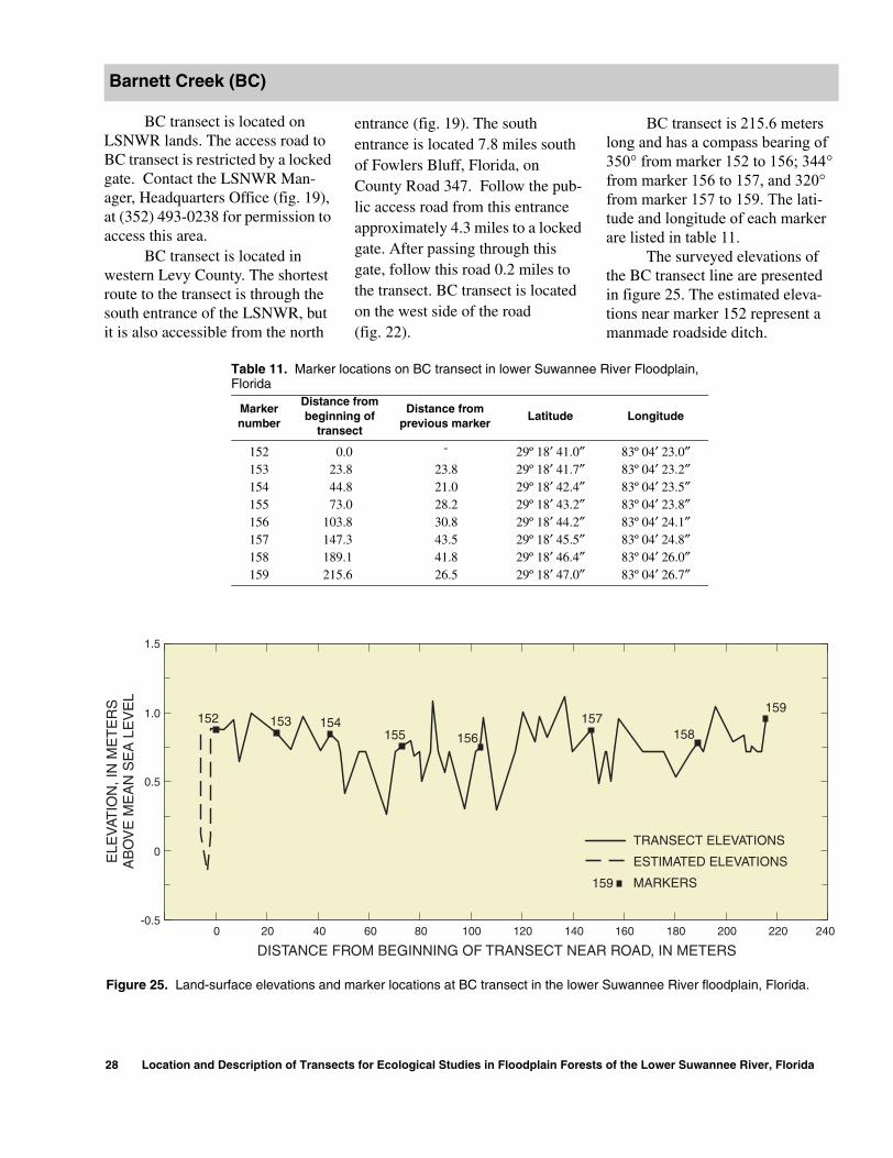
BC transect is located on LSNWR lands. The access road to BC transect is restricted by a locked gate. Contact the LSNWR Man-ager, Headquarters Office (fig. 19), at (352) 493-0238 for permission to access this area.
BC transect is located in western Levy County. The shortest route to the transect is through the south entrance of the LSNWR, but it is also accessible from the north
Barnett Creek (BC)
28 Location and Description of Transec
entrance (fig. 19). The south entrance is located 7.8 miles south of Fowlers Bluff, Florida, on County Road 347. Follow the pub-lic access road from this entrance approximately 4.3 miles to a locked gate. After passing through this gate, follow this road 0.2 miles to the transect. BC transect is located on the west side of the road (fig. 22).
ts for Ecological Studies in Floodplain Forest
BC transect is 215.6 meters long and has a compass bearing of 350° from marker 152 to 156; 344° from marker 156 to 157, and 320° from marker 157 to 159. The lati-tude and longitude of each marker are listed in table 11.
The surveyed elevations of the BC transect line are presented in figure 25. The estimated eleva-tions near marker 152 represent a manmade roadside ditch.
Table 11. Marker locations on BC transect in lower Suwannee River Floodplain,Florida
Marker number
Distance from beginning of
transect
Distance from previous marker
Latitude Longitude
152 0.0 - 29º 18′ 41.0″ 83º 04′ 23.0″153 23.8 23.8 29º 18′ 41.7″ 83º 04′ 23.2″154 44.8 21.0 29º 18′ 42.4″ 83º 04′ 23.5″155 73.0 28.2 29º 18′ 43.2″ 83º 04′ 23.8″156 103.8 30.8 29º 18′ 44.2″ 83º 04′ 24.1″157 147.3 43.5 29º 18′ 45.5″ 83º 04′ 24.8″158 189.1 41.8 29º 18′ 46.4″ 83º 04′ 26.0″159 215.6 26.5 29º 18′ 47.0″ 83º 04′ 26.7″
152 153 154155 156
157158
159
TRANSECT ELEVATIONS
ESTIMATED ELEVATIONS
MARKERS159
-0.5
0
0.5
1.0
1.5
ELE
VAT
ION
, IN
ME
TE
RS
AB
OV
E M
EA
N S
EA
LE
VE
L
1800 20 40 60 80 100 120 140 160 240200 220
DISTANCE FROM BEGINNING OF TRANSECT NEAR ROAD, IN METERS
Figure 25. Land-surface elevations and marker locations at BC transect in the lower Suwannee River floodplain, Florida.
s of the Lower Suwannee River, Florida
LEVYCOUNTY
Area shownin figure 27
Suwannee
DM LK
ToOld
Townion and name
N
D
AD
1 MILE
ETER
DIXIECOUNTY
349
SUWANNEE
LOC
KC
REEK
DEMORY
CREEK
WE
STPA
SS
EA
ST PASS
GOPHE
R
RIVER
RIVER
83°06′83°08′
ations and surrounding area in the lower Suwannee River floodplain, Florida.
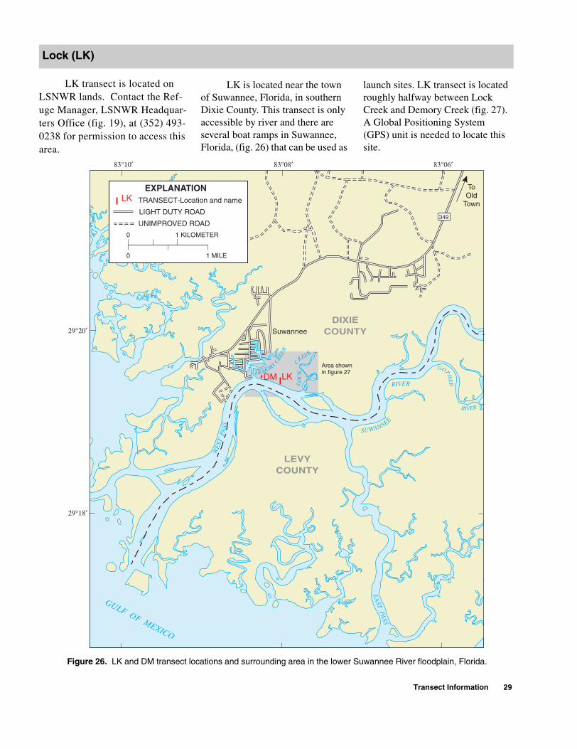
LK transect is located on LSNWR lands. Contact the Ref-uge Manager, LSNWR Headquar-ters Office (fig. 19), at (352) 493-0238 for permission to access this area.
Lock (LK)
TRANSECT-Locat
EXPLANATIOLK
LIGHT DUTY ROA
UNIMPROVED RO
0
0
1 KILOM
GULF OF MEXICO
29°18′
29°20′
83°10′
Figure 26. LK and DM transect loc
LK is located near the town of Suwannee, Florida, in southern Dixie County. This transect is only accessible by river and there are several boat ramps in Suwannee, Florida, (fig. 26) that can be used as
launch sites. LK transect is located roughly halfway between Lock Creek and Demory Creek (fig. 27). A Global Positioning System (GPS) unit is needed to locate this site.
Transect Information 29
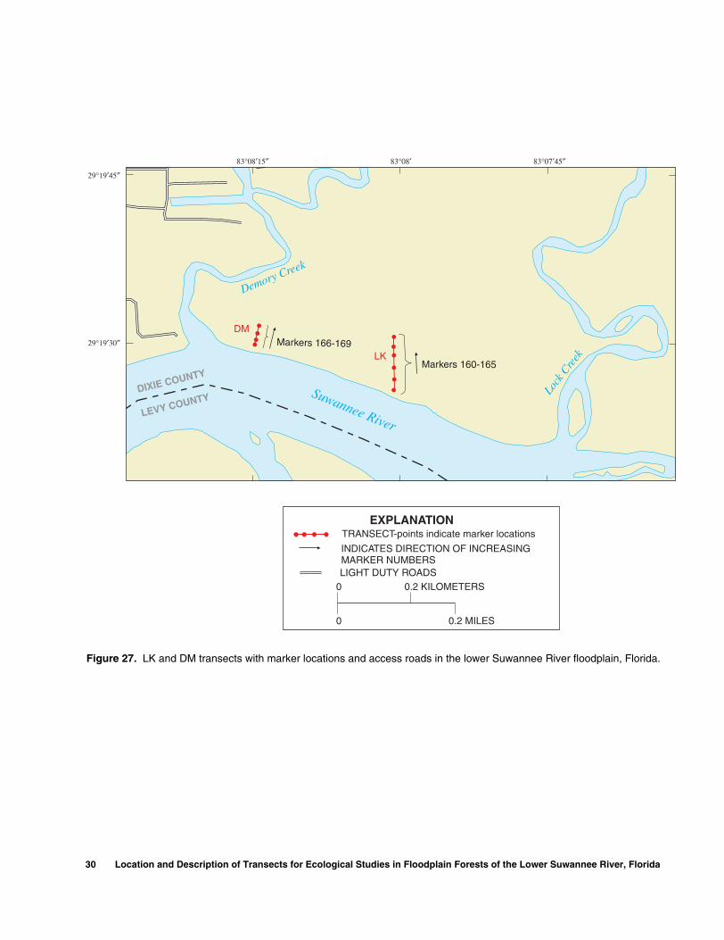
Suwannee River
Lock
Cre
ek
Demory Creek
LEVY COUNTYDIXIE COUNTY
Markers 166-169
Markers 160-165
0
0.2 MILES0
0.2 KILOMETERS
TRANSECT-points indicate marker locations
INDICATES DIRECTION OF INCREASINGMARKER NUMBERSLIGHT DUTY ROADS
EXPLANATION
83°08′15″ 83°08′ 83°07′45″
29°19′45″
29°19′30″
DM
LK
Figure 27. LK and DM transects with marker locations and access roads in the lower Suwannee River floodplain, Florida.
30 Location and Description of Transects for Ecological Studies in Floodplain Forests of the Lower Suwannee River, Florida
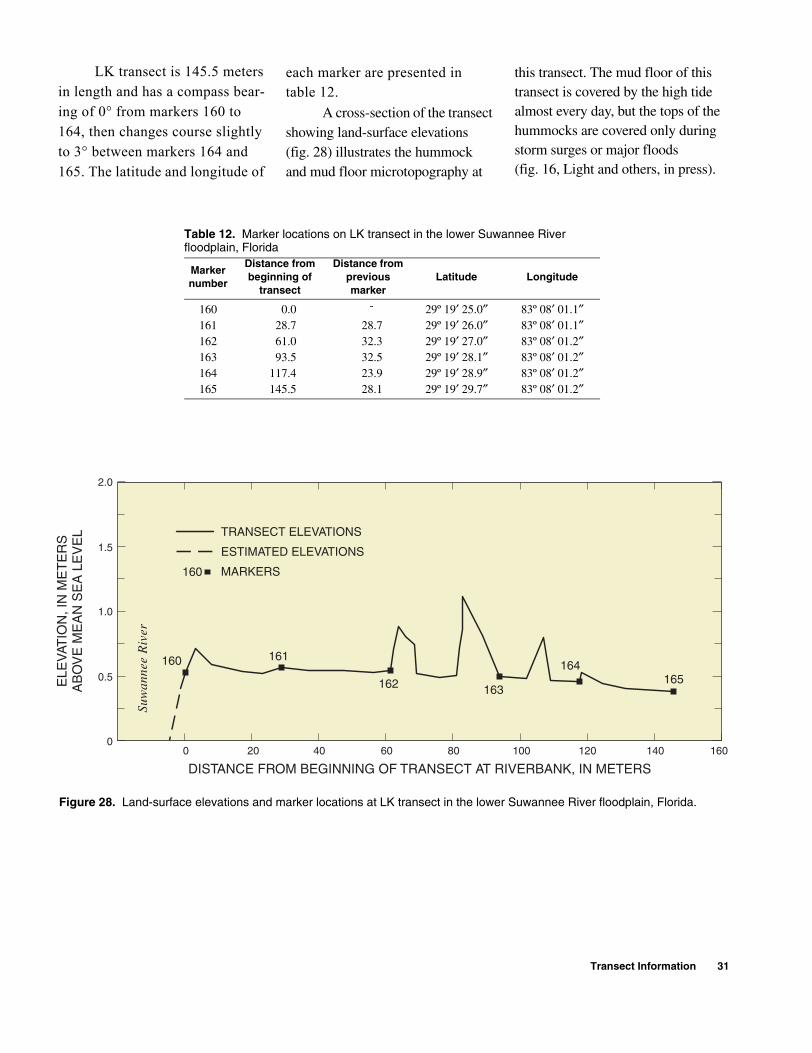
LK transect is 145.5 meters in length and has a compass bear-ing of 0° from markers 160 to 164, then changes course slightly to 3° between markers 164 and 165. The latitude and longitude of
each marker are presented in table 12.
A cross-section of the transect showing land-surface elevations (fig. 28) illustrates the hummock and mud floor microtopography at
this transect. The mud floor of this transect is covered by the high tide almost every day, but the tops of the hummocks are covered only during storm surges or major floods (fig. 16, Light and others, in press).
Table 12. Marker locations on LK transect in the lower Suwannee Riverfloodplain, Florida
Marker number
Distance from beginning of
transect
Distance from previous marker
Latitude Longitude
160 0.0 - 29º 19′ 25.0″ 83º 08′ 01.1″161 28.7 28.7 29º 19′ 26.0″ 83º 08′ 01.1″162 61.0 32.3 29º 19′ 27.0″ 83º 08′ 01.2″163 93.5 32.5 29º 19′ 28.1″ 83º 08′ 01.2″164 117.4 23.9 29º 19′ 28.9″ 83º 08′ 01.2″165 145.5 28.1 29º 19′ 29.7″ 83º 08′ 01.2″
160 161
162 163
164165
TRANSECT ELEVATIONS
ESTIMATED ELEVATIONS
MARKERS160
Suw
anne
eR
iver
0 20 40 60 80 100 120 140 160
DISTANCE FROM BEGINNING OF TRANSECT AT RIVERBANK, IN METERS
ELE
VAT
ION
, IN
ME
TE
RS
AB
OV
E M
EA
N S
EA
LE
VE
L
0
0.5
1.0
1.5
2.0
Figure 28. Land-surface elevations and marker locations at LK transect in the lower Suwannee River floodplain, Florida.
Transect Information 31
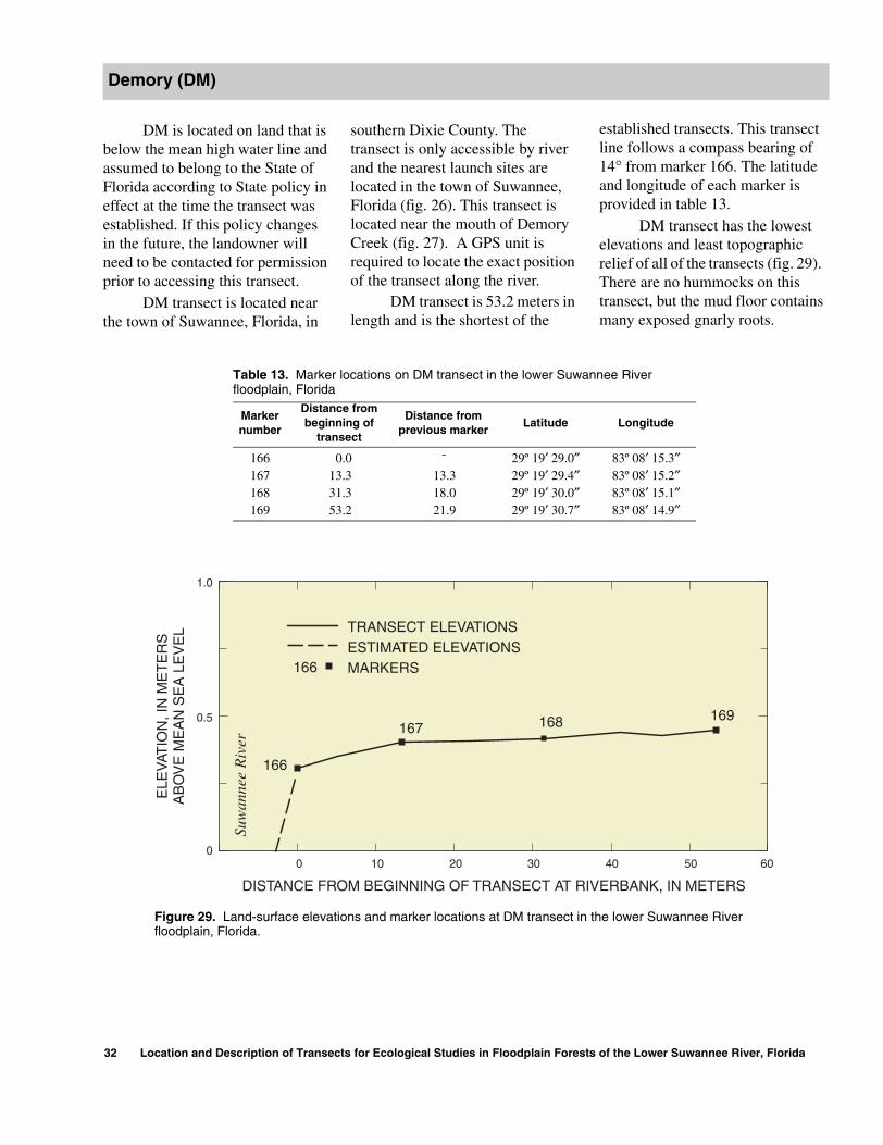
DM is located on land that is below the mean high water line and assumed to belong to the State of Florida according to State policy in effect at the time the transect was established. If this policy changes in the future, the landowner will need to be contacted for permission prior to accessing this transect.
DM transect is located near the town of Suwannee, Florida, in
Demory (DM)
32 Location and Description of Transec
southern Dixie County. The transect is only accessible by river and the nearest launch sites are located in the town of Suwannee, Florida (fig. 26). This transect is located near the mouth of Demory Creek (fig. 27). A GPS unit is required to locate the exact position of the transect along the river.
DM transect is 53.2 meters in length and is the shortest of the
ts for Ecological Studies in Floodplain Forest
established transects. This transect line follows a compass bearing of 14° from marker 166. The latitude and longitude of each marker is provided in table 13.
DM transect has the lowest elevations and least topographic relief of all of the transects (fig. 29). There are no hummocks on this transect, but the mud floor contains many exposed gnarly roots.
Table 13. Marker locations on DM transect in the lower Suwannee Riverfloodplain, Florida
Marker number
Distance from beginning of
transect
Distance from previous marker
Latitude Longitude
166 0.0 - 29º 19′ 29.0″ 83º 08′ 15.3″167 13.3 13.3 29º 19′ 29.4″ 83º 08′ 15.2″168 31.3 18.0 29º 19′ 30.0″ 83º 08′ 15.1″169 53.2 21.9 29º 19′ 30.7″ 83º 08′ 14.9″
TRANSECT ELEVATIONSESTIMATED ELEVATIONSMARKERS166
Suw
anne
e R
iver
166
167 168 169
0 10 20 30 40 50 60
DISTANCE FROM BEGINNING OF TRANSECT AT RIVERBANK, IN METERS
ELE
VAT
ION
, IN
ME
TE
RS
AB
OV
E M
EA
N S
EA
LE
VE
L
0
0.5
1.0
Figure 29. Land-surface elevations and marker locations at DM transect in the lower Suwannee River floodplain, Florida.
s of the Lower Suwannee River, Florida

REFERENCES
Clewell, A.F., 1985, Guide to the vascular plants of the Florida Panhandle: Tallahassee, Florida State University Press, 605 p.
Darst, M.R., Light, H. M., and Lewis, L.J., 2002, Ground cover vegetation in wetland forests in the Lower Suwannee River floodplain, Florida, and potential
impacts of flow reductions: U.S. Geological Survey Water-Resources Investigations Report 02-4027.
Godfrey, R.K., 1988, Trees, shrubs, and woody vines of northern Florida and adjacent Georgia and Alabama: Athens, The University of Georgia Press, 734 p.
Light, H.M., Darst, M.R., Lewis, L.J., and Howell, D.A., in press, Hydrology, vegetation, and soils of riverine and tidal floodplain forests of the lower Suwannee River, Florida, and potential impacts of flow reductions: U.S. Geological Survey Professional Paper 1656A.
References 33

34 Location and Description of Transects for Ecological Studies in Floodplain Forests of the Lower Suwannee River, Florida

Appendixes

36 Location and Description of Transects for Ecological Studies in Floodplain Forests of the Lower Suwannee River, Florida

Appendix 1. Canopy tree species and measurements and marker locations on transects in the lower Suwannee River floodplain, Florida
This appendix contains the following sections:A CF transectB LL transectC FK transectD MS transectE KN transectF KI transectG TK transectH SN transectI SH transectJ BC transectK LK transectL DM transect
[cm, centimeters; m, meters; dbh, diameter at breast height; separate measurements for dbh are shown for trunks of multiple trunked trees greater than 4 cm]
List of tree species codes with scientific names and common name equivalents[Plant nomenclature used in this report follows that by Godfrey (1988) unless otherwise indicated]
Code Scientific Name Common nameacerub Acer rubrum L. red maplebetnig Betula nigra L. river birchcarcar Carpinus caroliniana Walt. ironwoodcaraqu Carya aquatica (Michx. f.) Nutt. water hickorycargla Carya glabra (Mill.) Sweet pignut hickorycellae Celtis laevigata Nutt. hackberrycepocc Cephalanthus occidentalis L. buttonbushcorfoe Cornus foemina Mill. stiffcornel dogwoodcrafla Crataegus flava Ait. yellow hawcravir Crataegus viridis L. green hawcyrrac Cyrilla racemiflora L. titidiovir Diospyros virginiana L. persimmonforacu Forestiera acuminata (Michx.) Poir. in Lam. swamp-privetfracar Fraxinus caroliniana Mill. pop ashfrapro Fraxinus profunda (Bush) Bush pumpkin ashgleaqu Gleditsia aquatica Marsh. water locustilecas Ilex cassine L. dahooniledec Ilex decidua Walt. var. curtissii Fern. possum-hawileopa Ilex opaca Ait. var. opaca American hollyjunsil Juniperus silicicola (Small) Bailey 1 southern red cedarliqsty Liquidambar styraciflua L. sweetgummagvir Magnolia virginiana L. sweetbaymyrcer Myrica cerifera L. wax-myrtlenysaqu Nyssa aquatica L. water tupelonysbif Nyssa biflora Walt.1 swamp gumnyssyl Nyssa sylvatica Marsh.1 blackgumostvir Ostrya virginiana (Mill.) K. Koch eastern hophornbeamperpal Persea palustris (Raf.) Sarg. swamp red baypinell Pinus elliottii Engelm. var. elliottii slash pinepingla Pinus glabra Walt. spruce pinepintae Pinus taeda L. planer-treeplaaqu Planera aquatica J. F. Gmel. loblolly pine
Appendix 1 37

quegem Quercus geminata Small sand live oakquehem Quercus hemisphaerica Bartr. ex Willd. laurel oakquelau Quercus laurifolia Michx. swamp laurel oakquelyr Quercus lyrata Walt. overcup oakquenig Quercus nigra L. water oakquevir Quercus virginiana Mill. live oaksabpal Sabal palmetto Lodd. ex J. S. Shult. & J. H. Shult. cabbage palmsalcar Salix caroliniana Michx. Carolina willowsalnig Salix nigra L. black willowtaxdis Taxodium distichum (L.) L. C. Rich. bald cypressulmala Ulmus alata Michx. winged elmulmame Ulmus americana L. American elmulmcra Ulmus crassifolia Nutt. cedar elmvacarb Vaccinium arboreum Marsh. sparkleberryvibobo Viburnum obovatum Walt. small viburnumvitcin Vitis cinerea (Engelm. ex Gray) Millardet downy winter grape
var. floridana Munson
1Clewell (1985).
Appendix 1. Canopy tree species and measurements and marker locations on transects in the lower Suwannee River floodplain, Florida (Continued)
38 Location and Description of Transects for Ecological Studies in Floodplain Forests of the Lower Suwannee River, Florida
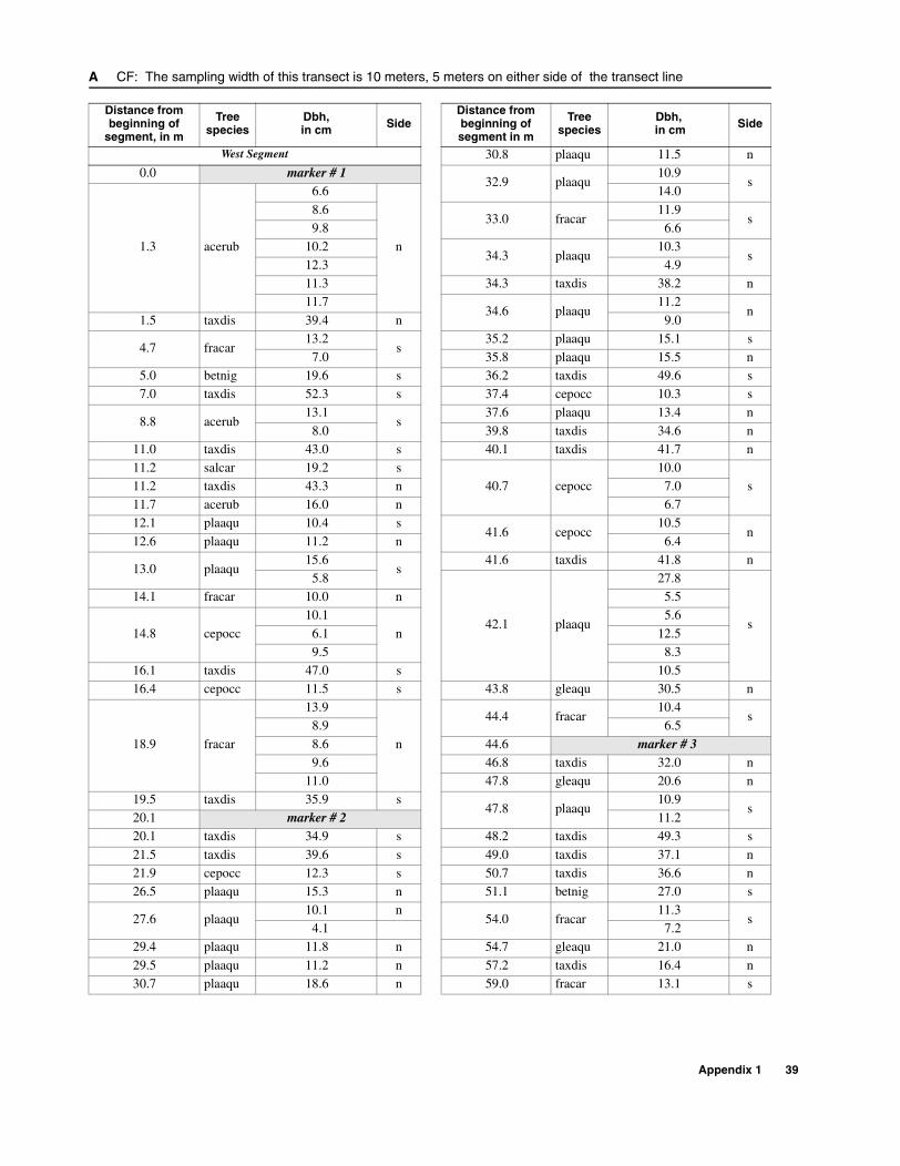
A CF: The sampling width of this transect is 10 meters, 5 meters on either side of the transect line
Distance from beginning of
segment, in m
Tree species
Dbh,in cm Side
Distance from beginning ofsegment in m
Tree species
Dbh, in cm Side
West Segment 30.8 plaaqu 11.5 n0.0 marker # 1
32.9 plaaqu10.9
s
1.3 acerub
6.6
n
14.0
8.633.0 fracar
11.9s
9.8 6.610.2
34.3 plaaqu10.3
s12.3 4.911.3 34.3 taxdis 38.2 n11.7
34.6 plaaqu11.2
n1.5 taxdis 39.4 n 9.0
4.7 fracar13.2
s35.2 plaaqu 15.1 s
7.0 35.8 plaaqu 15.5 n5.0 betnig 19.6 s 36.2 taxdis 49.6 s7.0 taxdis 52.3 s 37.4 cepocc 10.3 s
8.8 acerub13.1
s37.6 plaaqu 13.4 n
8.0 39.8 taxdis 34.6 n11.0 taxdis 43.0 s 40.1 taxdis 41.7 n11.2 salcar 19.2 s
40.7 cepocc10.0
s11.2 taxdis 43.3 n 7.011.7 acerub 16.0 n 6.712.1 plaaqu 10.4 s
41.6 cepocc10.5
n12.6 plaaqu 11.2 n 6.4
13.0 plaaqu15.6
s41.6 taxdis 41.8 n
5.8
42.1 plaaqu
27.8
s
14.1 fracar 10.0 n 5.5
14.8 cepocc
10.1
n
5.6
6.1 12.59.5 8.3
16.1 taxdis 47.0 s 10.516.4 cepocc 11.5 s 43.8 gleaqu 30.5 n
18.9 fracar
13.9
n
44.4 fracar10.4
s8.9 6.5
8.6 44.6 marker # 39.6 46.8 taxdis 32.0 n
11.0 47.8 gleaqu 20.6 n19.5 taxdis 35.9 s
47.8 plaaqu10.9
s20.1 marker # 2 11.220.1 taxdis 34.9 s 48.2 taxdis 49.3 s
21.5 taxdis 39.6 s 49.0 taxdis 37.1 n21.9 cepocc 12.3 s 50.7 taxdis 36.6 n26.5 plaaqu 15.3 n 51.1 betnig 27.0 s
27.6 plaaqu10.1 n
54.0 fracar11.3
s4.1 7.2
29.4 plaaqu 11.8 n 54.7 gleaqu 21.0 n
29.5 plaaqu 11.2 n 57.2 taxdis 16.4 n30.7 plaaqu 18.6 n 59.0 fracar 13.1 s
Appendix 1 39

59.7 cepocc 12.0 s 86.6 salcar 11.0 s
60.0 fracar 11.5 n 87.3 salcar 10.1 n
62.6 fracar
8.7 n 87.9 salcar 12.6 s12.4
n88.6 marker # 5
10.5 89.9 betnig 12.5 n9.6 89.9 salcar 15.7 s
63.7 fracar 11.3 n 91.1 salnig 12.6 n
65.1 fracar 11.2 n 95.1 quelyr 24.1 n65.1 taxdis 48.4 s 99.6 quelau 14.2 n65.2 fracar 11.3 s 100.8 liqsty 23.0 n68.3 marker # 4 101.1 quelau 25.6 n69.6 gleaqu 16.7 n 102.0 liqsty 18.6 n69.9 fracar 10.1 n 102.1 liqsty 20.0 s
70.0 fracar11.9
n102.3 quelau 17.5 n
5.5 102.3 taxdis 18.8 s70.1 betnig 24.7 n 102.8 quelau 12.1 n70.1 fracar 14.3 n 102.8 taxdis 16.9 s
71.1 plaaqu16.0
n 103.1 snag19.4
s4.3 17.5
71.5 fracar 12.1 s 104.3 quelau 20.7 s72.5 gleaqu 20.2 s
105.4 betnig12.8
s73.5 plaaqu 13.8 n 11.7
74.5 fracar13.4
n105.4 taxdis 13.1 n
7.1 105.6 betnig 13.9 s75.9 fracar 14.6 n 115.5 marker # 6
76.8 gleaqu25.6
n115.9 quelau 35.2 s
20.0 120.0 quelau 25.4 s
77.9 fracar10.9
s 120.5 cyrrac10.0
n12.6 6.8
80.0 taxdis 17.9 n123.5 nyssyl
27.5n
80.0 taxdis 17.8 s 25.0
80.5 fracar
10.7
s
128.3 marker # 77.8 East Segment
6.3 0.0 marker # 85.9
0.6 cravir10.6
s8.1 10.1
81.0 plaaqu 18.7 s 6.0
81.2 fracar10.6
n2.2 betnig 14.6 s
7.2 2.7 quelau 57.4 n6.9 3.9 betnig 14.4 s
82.8 fracar 14.4 s 4.3 quelau 47.4 n83.8 taxdis 17.2 n 5.8 taxdis 24.0 n
84.0 taxdis 18.9 n 10.6 betnig 20.0 s
84.6 plaaqu22.8
s10.6 betnig 16.2 s
10.8 12.2 gleaqu 22.1 s85.6 snag 12.1 s 12.9 liqsty 23.9 s85.8 plaaqu 17.2 s 13.3 taxdis 34.5 s
A CF: The sampling width of this transect is 10 meters, 5 meters on either side of the transect line (Continued)
Distance from beginning of
segment, in m
Tree species
Dbh,in cm Side
Distance from beginning ofsegment in m
Tree species
Dbh, in cm Side
40 Location and Description of Transects for Ecological Studies in Floodplain Forests of the Lower Suwannee River, Florida

13.7 liqsty 10.0 n
39.1 taxdis
29.7
n13.8 taxdis 29.0 s 30.014.8 taxdis 17.5 n 10.515.2 taxdis 24.6 n 39.016.1 plaaqu 36.0 s
39.9 taxdis
31.5
s16.5 plaaqu
25.3n
24.36.6 17.3
5.9 28.517.3 taxdis 22.4 n 40.8 plaaqu 34.0 s17.3 taxdis 23.9 n
42.1 taxdis37.1
n17.3 taxdis 48.0 n 29.0
18.0 plaaqu
22.0
n
12.822.1
47.1 fracar
12.2
s9.0 8.020.0 11.5
19.9 fracar12.6
s
47.3 taxdis
11.1
n
9.6 27.522.1 marker # 9 26.723.7 acerub 21.9 s 22.8
24.1 snag 20.0 n 21.424.5 acerub 10.5 s 25.624.7 gleaqu 14.4 s 48.9 betnig 13.7 s26.5 betnig 21.1 n
49.4 fracar
11.2
s28.5 fracar9.5
s8.5
11.1 12.3
8.6 6.4
29.5 fracar
11.6
s
5.89.3
53.3 fracar
9.2
n4.1 6.26.5 9.7
6.4 7.49.6 7.28.0 53.7 taxdis 19.7 n4.7 53.9 marker # 106.5 54.2 betnig 11.9 n
33.7 gleaqu 15.5 n
56.0 taxdis
23.3
n34.1 betnig 12.6 s 21.034.5 cepocc 12.5 s 27.7
37.4 taxdis30.9
s56.6 taxdis
12.5
n15.3 24.3
38.1 plaaqu
19.9
s
30.110.4 27.9
4.8
58.0 taxdis
19.4
s7.5 17.28.0 38.0
17.0
A CF: The sampling width of this transect is 10 meters, 5 meters on either side of the transect line (Continued)
Distance from beginning of
segment, in m
Tree species
Dbh,in cm Side
Distance from beginning ofsegment in m
Tree species
Dbh, in cm Side
Appendix 1 41

42 Location and Description of Transects for Ecological Studies in Floodplain Forests of the Lower Suwannee River, Florida
58.5 taxdis 40.8 s
102.4 fracar
10.4
s
59.1 taxdis 44.7 n 6.060.4 taxdis 23.0 n 10.861.5 betnig 10.7 n 7.463.2 plaaqu 42.3 s 8.464.1 betnig 12.4 s 5.765.0 taxdis 40.6 s
103.7 fracar
12.3
n
69.7 fracar
10.6
n
12.45.4 12.58.9 4.77.5
105.0 fracar
12.3
n9.4 7.36.9 10.1
8.2 8.910.0 106.8 marker # 129.9 107.8 taxdis 25.5 s
71.2 taxdis27.8
n107.9 taxdis 27.3 n
25.9 107.9 taxdis 37.4 n23.8 108.9 taxdis 32.6 n
79.2 taxdis 45.2 n 109.9 taxdis 33.0 s79.9 marker # 11 110.3 gleaqu 18.6 n
79.8 taxdis12.8
n
110.8 fracar
8.0
n
29.0 10.237.1 11.5
84.1 taxdis 42.5 n 4.9
88.3 plaaqu
4.5
n
9.08.6 5.2
11.4 113.8 plaaqu 14.4 n12.3 114.2 betnig 20.0 n12.5
114.4 plaaqu12.9
s8.7 6.08.3 116.2 caraqu 14.5 s
21.6 117.3 plaaqu 14.8 s10.3 117.5 gleaqu 11.7 n16.9 117.7 plaaqu 17.6 n
88.4 taxdis 35.0 s117.9 betnig
15.5s
88.9 taxdis 30.4 n 12.192.7 taxdis 32.6 n
118.0 plaaqu20.5
n95.1 plaaqu
18.8s
7.08.8
119.8 fracar
12.5
n95.8 betnig 10.6 s 8.097.7 taxdis 44.5 n 8.6
99.1 taxdis 35.6 n 7.4
100.4 taxdis
19.9
s
120.4 fracar12.4
n26.4 9.626.0 4.027.3 121.4 plaaqu 10.1 s29.1 122.7 taxdis 45.2 n
24.9 123.1 gleaqu 27.4 s
A CF: The sampling width of this transect is 10 meters, 5 meters on either side of the transect line (Continued)
Distance from beginning of
segment, in m
Tree species
Dbh,in cm Side
Distance from beginning ofsegment in m
Tree species
Dbh, in cm Side
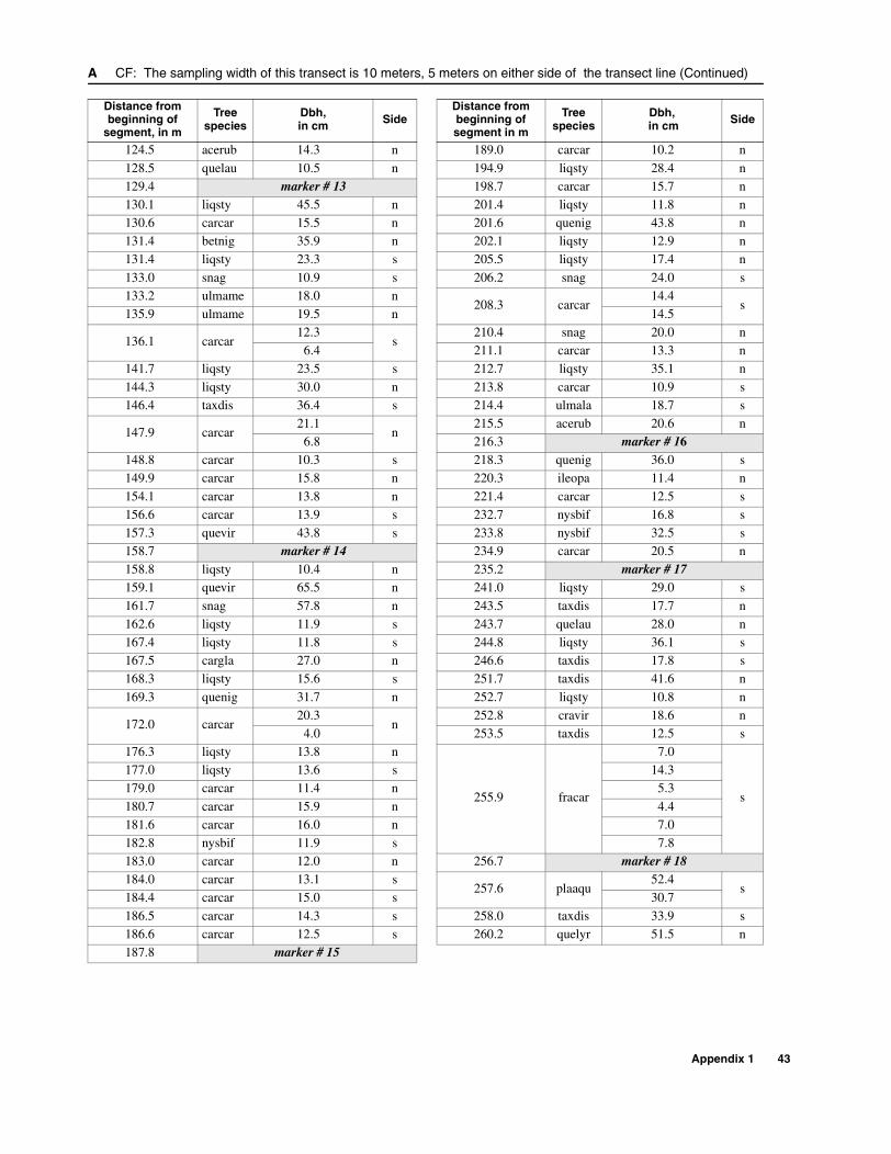
124.5 acerub 14.3 n 189.0 carcar 10.2 n
128.5 quelau 10.5 n 194.9 liqsty 28.4 n129.4 marker # 13 198.7 carcar 15.7 n130.1 liqsty 45.5 n 201.4 liqsty 11.8 n130.6 carcar 15.5 n 201.6 quenig 43.8 n131.4 betnig 35.9 n 202.1 liqsty 12.9 n131.4 liqsty 23.3 s 205.5 liqsty 17.4 n
133.0 snag 10.9 s 206.2 snag 24.0 s133.2 ulmame 18.0 n
208.3 carcar14.4
s135.9 ulmame 19.5 n 14.5
136.1 carcar12.3
s210.4 snag 20.0 n
6.4 211.1 carcar 13.3 n141.7 liqsty 23.5 s 212.7 liqsty 35.1 n
144.3 liqsty 30.0 n 213.8 carcar 10.9 s146.4 taxdis 36.4 s 214.4 ulmala 18.7 s
147.9 carcar21.1
n215.5 acerub 20.6 n
6.8 216.3 marker # 16148.8 carcar 10.3 s 218.3 quenig 36.0 s149.9 carcar 15.8 n 220.3 ileopa 11.4 n
154.1 carcar 13.8 n 221.4 carcar 12.5 s156.6 carcar 13.9 s 232.7 nysbif 16.8 s157.3 quevir 43.8 s 233.8 nysbif 32.5 s158.7 marker # 14 234.9 carcar 20.5 n158.8 liqsty 10.4 n 235.2 marker # 17159.1 quevir 65.5 n 241.0 liqsty 29.0 s
161.7 snag 57.8 n 243.5 taxdis 17.7 n162.6 liqsty 11.9 s 243.7 quelau 28.0 n167.4 liqsty 11.8 s 244.8 liqsty 36.1 s167.5 cargla 27.0 n 246.6 taxdis 17.8 s168.3 liqsty 15.6 s 251.7 taxdis 41.6 n
169.3 quenig 31.7 n 252.7 liqsty 10.8 n
172.0 carcar20.3
n252.8 cravir 18.6 n
4.0 253.5 taxdis 12.5 s176.3 liqsty 13.8 n
255.9 fracar
7.0
s
177.0 liqsty 13.6 s 14.3179.0 carcar 11.4 n 5.3
180.7 carcar 15.9 n 4.4181.6 carcar 16.0 n 7.0182.8 nysbif 11.9 s 7.8183.0 carcar 12.0 n 256.7 marker # 18184.0 carcar 13.1 s
257.6 plaaqu52.4
s184.4 carcar 15.0 s 30.7
186.5 carcar 14.3 s 258.0 taxdis 33.9 s186.6 carcar 12.5 s 260.2 quelyr 51.5 n187.8 marker # 15
A CF: The sampling width of this transect is 10 meters, 5 meters on either side of the transect line (Continued)
Distance from beginning of
segment, in m
Tree species
Dbh,in cm Side
Distance from beginning ofsegment in m
Tree species
Dbh, in cm Side
Appendix 1 43

A CF: The sampling width of this transect is 10 meters, 5 meters on either side of the transect line (Continued)
Distance from beginning of
segment, in mTree species
Dbh,in cm
Side
262.9 fracar
4.5
n8.4
11.6
266.6 plaaqu 35.0 s
268.0 plaaqu
29.7
n6.0
13.2
270.3 plaaqu 24.0 n
277.2 ulmame 19.0 n
280.1 ulmame 15.9 s
281.2 ulmame 17.7 s
284.7 acerub 10.3 n
286.1 marker # 19
288.1 quelau 17.6 s
289.5 caraqu 11.9 s
290.6 acerub 13.5 n
293.5 betnig 15.5 s
294.1 carcar 15.4 n
296.3 liqsty 11.8 n
298.5 liqsty 14.4 n
300.7 liqsty 11.8 n
300.8 marker # 20
301.5 carcar 13.6 s
302.5 carcar 22.7 n
302.6 carcar 25.2 s
304.7 snag 81.0 s
308.1 betnig 17.1 n
308.1 betnig 17.5 n
308.5 salcar 11.8 s
310.7 marker # 21
311.1 betnig 10.0 n
312.7 taxdis 45.0 n
312.7 taxdis 62.0 s
44 Location and Description of Transects for Ecological Studies in Floodplain Forests of the Lower Suwannee River, Florida
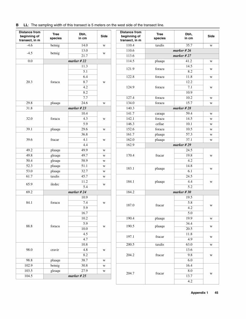
Appendix 1 45
B LL: The sampling width of this transect is 5 meters on the west side of the transect line.
Distance from beginning of transect, in m
Treespecies
Dbh,in cm
SideDistance from beginning oftransect, in m
Treespecies
Dbh,in cm
Side
-4.6 betnig 14.0 w 110.4 taxdis 35.7 w
-4.5 betnig13.0
w110.6 marker # 26
21.7 113.6 marker # 27
0.0 marker # 22 114.5 plaaqu 41.2 w
20.3 foracu
11.3
w
121.9 foracu14.5
w5.1 8.2
6.4 122.8 foracu 11.8 w
8.7
124.9 foracu
12.2
w4.2 7.1
8.2 10.9
7.7 127.4 foracu 10.2 w
29.8 plaaqu 24.6 w 134.0 foracu 15.7 w
31.8 marker # 23 140.3 marker # 28
32.0 foracu
10.4
w
141.7 caraqu 59.4 w
4.3 142.1 foracu 14.5 w
5.9 146.3 cellae 10.1 w
39.1 plaaqu 29.6 w 152.6 foracu 10.5 w
39.6 fracar
36.8
w
161.7 plaaqu 57.3 w
4.1 162.0 plaaqu 37.1 w
4.4 162.9 marker # 29
49.2 plaaqu 49.9 w
170.4 fracar
24.5
w49.8 gleaqu 49.7 w 19.8
50.4 gleaqu 58.9 w 4.2
52.3 plaaqu 51.1 w183.1 plaaqu
14.8w
53.0 plaaqu 32.7 w 6.1
61.7 taxdis 45.7 w
184.1 plaaqu
24.5
w65.9 iledec
11.2w
4.4
5.4 5.2
69.2 marker # 24 184.2 marker # 30
84.1 foracu
10.9
w187.0 fracar
19.5
w7.4 5.8
5.9 4.2
88.8 foracu
16.7
w
5.0
10.2 190.4 plaaqu 19.9 w
5.9190.5 plaaqu
34.4w
10.0 20.5
4.5197.1 fracar
11.8w
4.7 4.9
98.0 cravir
10.8
w
200.5 taxdis 63.0 w
4.8
204.2 fracar
13.6
w8.2 9.8
98.8 plaaqu 38.7 w 6.0
102.9 betnig 30.8 w
204.7 fracar
16.4
w103.5 gleaqu 27.9 w 8.0
104.5 marker # 25 13.7
4.2
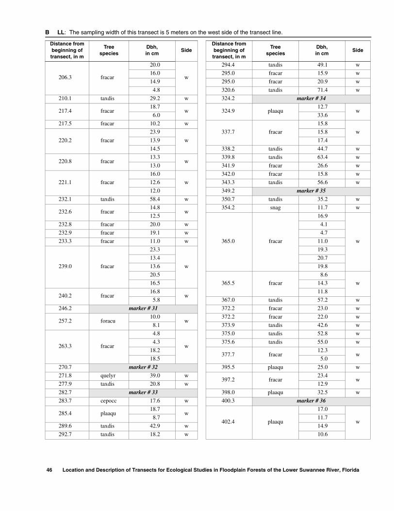
206.3 fracar
20.0
w
294.4 taxdis 49.1 w
16.0 295.0 fracar 15.9 w
14.9 295.0 fracar 20.9 w
4.8 320.6 taxdis 71.4 w
210.1 taxdis 29.2 w 324.2 marker # 34
217.4 fracar18.7
w 324.9 plaaqu12.7
w6.0 33.6
217.5 fracar 10.2 w
337.7 fracar
15.8
w
220.2 fracar
23.9
w
15.8
13.9 17.4
14.5 338.2 taxdis 44.7 w
220.8 fracar13.3
w339.8 taxdis 63.4 w
13.0 341.9 fracar 26.6 w
221.1 fracar
16.0
w
342.0 fracar 15.8 w
12.6 343.3 taxdis 56.6 w
12.0 349.2 marker # 35
232.1 taxdis 58.4 w 350.7 taxdis 35.2 w
232.6 fracar14.8
w354.2 snag 11.7 w
12.5
365.0 fracar
16.9
w
232.8 fracar 20.0 w 4.1
232.9 fracar 19.1 w 4.7
233.3 fracar 11.0 w 11.0
239.0 fracar
23.3
w
19.3
13.4 20.7
13.6 19.8
20.5
365.5 fracar
8.6
w16.5 14.3
240.2 fracar16.8
w11.8
5.8 367.0 taxdis 57.2 w
246.2 marker # 31 372.2 fracar 23.0 w
257.2 foracu10.0
w372.2 fracar 22.0 w
8.1 373.9 taxdis 42.6 w
263.3 fracar
4.8
w
375.0 taxdis 52.8 w
4.3 375.6 taxdis 55.0 w
18.2377.7 fracar
12.3w
18.5 5.0
270.7 marker # 32 395.5 plaaqu 25.0 w
271.8 quelyr 39.0 w397.2 fracar
23.4w
277.9 taxdis 20.8 w 12.9
282.7 marker # 33 398.0 plaaqu 32.5 w
283.7 cepocc 17.6 w 400.3 marker # 36
285.4 plaaqu18.7
w
402.4 plaaqu
17.0
w8.7 11.7
289.6 taxdis 42.9 w 14.9
292.7 taxdis 18.2 w 10.6
B LL: The sampling width of this transect is 5 meters on the west side of the transect line.
Distance from beginning of transect, in m
Treespecies
Dbh,in cm
SideDistance from beginning oftransect, in m
Treespecies
Dbh,in cm
Side
46 Location and Description of Transects for Ecological Studies in Floodplain Forests of the Lower Suwannee River, Florida
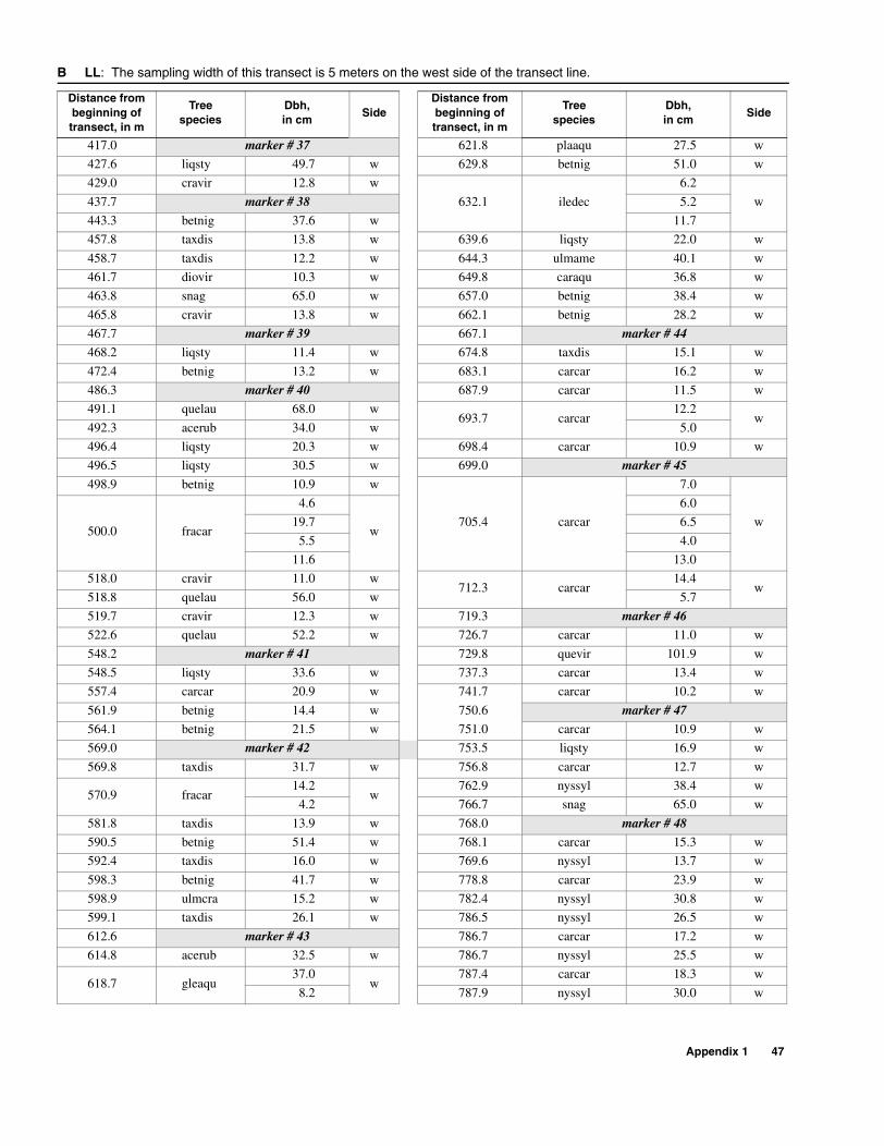
417.0 marker # 37 621.8 plaaqu 27.5 w
427.6 liqsty 49.7 w 629.8 betnig 51.0 w
429.0 cravir 12.8 w
632.1 iledec
6.2
w437.7 marker # 38 5.2
443.3 betnig 37.6 w 11.7
457.8 taxdis 13.8 w 639.6 liqsty 22.0 w
458.7 taxdis 12.2 w 644.3 ulmame 40.1 w
461.7 diovir 10.3 w 649.8 caraqu 36.8 w
463.8 snag 65.0 w 657.0 betnig 38.4 w
465.8 cravir 13.8 w 662.1 betnig 28.2 w
467.7 marker # 39 667.1 marker # 44
468.2 liqsty 11.4 w 674.8 taxdis 15.1 w
472.4 betnig 13.2 w 683.1 carcar 16.2 w
486.3 marker # 40 687.9 carcar 11.5 w
491.1 quelau 68.0 w693.7 carcar
12.2w
492.3 acerub 34.0 w 5.0
496.4 liqsty 20.3 w 698.4 carcar 10.9 w
496.5 liqsty 30.5 w 699.0 marker # 45
498.9 betnig 10.9 w
705.4 carcar
7.0
w500.0 fracar
4.6
w
6.0
19.7 6.5
5.5 4.0
11.6 13.0
518.0 cravir 11.0 w712.3 carcar
14.4w
518.8 quelau 56.0 w 5.7
519.7 cravir 12.3 w 719.3 marker # 46
522.6 quelau 52.2 w 726.7 carcar 11.0 w
548.2 marker # 41 729.8 quevir 101.9 w
548.5 liqsty 33.6 w 737.3 carcar 13.4 w
557.4 carcar 20.9 w 741.7 carcar 10.2 w
561.9 betnig 14.4 w 750.6 marker # 47
564.1 betnig 21.5 w 751.0 carcar 10.9 w
569.0 marker # 42 753.5 liqsty 16.9 w
569.8 taxdis 31.7 w 756.8 carcar 12.7 w
570.9 fracar14.2
w762.9 nyssyl 38.4 w
4.2 766.7 snag 65.0 w
581.8 taxdis 13.9 w 768.0 marker # 48
590.5 betnig 51.4 w 768.1 carcar 15.3 w
592.4 taxdis 16.0 w 769.6 nyssyl 13.7 w
598.3 betnig 41.7 w 778.8 carcar 23.9 w
598.9 ulmcra 15.2 w 782.4 nyssyl 30.8 w
599.1 taxdis 26.1 w 786.5 nyssyl 26.5 w
612.6 marker # 43 786.7 carcar 17.2 w
614.8 acerub 32.5 w 786.7 nyssyl 25.5 w
618.7 gleaqu37.0
w787.4 carcar 18.3 w
8.2 787.9 nyssyl 30.0 w
B LL: The sampling width of this transect is 5 meters on the west side of the transect line.
Distance from beginning of transect, in m
Treespecies
Dbh,in cm
SideDistance from beginning oftransect, in m
Treespecies
Dbh,in cm
Side
Appendix 1 47

B LL: The sampling width of this transect is 5 meters on the west side of the transect line (Continued)
Distance from beginning of transect, in m
Treespecies
Dbh,in cm
Side
789.6 carcar 16.4 w
792.5 carcar 12.0 w
796.5 carcar 10.5 w
802.1 carcar 27.4 w
809.9 betnig 39.9 w
811.2 carcar 10.8 w
812.4 liqsty 16.1 w
814.3 liqsty 39.3 w
816.9 liqsty 13.4 w
822.3 liqsty 19.6 w
822.4 marker # 49
826.6 betnig 22.8 w
829.5 carcar 14.3 w
833.6 carcar 11.5 w
837.2 carcar 11.2 w
837.5 carcar 12.2 w
837.6 betnig 12.3 w
845.2 carcar24.6
w7.9
855.0 carcar 21.4 w
857.4 carcar 21.1 w
862.7 carcar 25.0 w
863.3 carcar 15.5 w
868.2 marker # 50
872.4 carcar 20.8 w
875.1 quevir 64.0 w
880.8 nyssyl 21.9 w
881.2 carcar 12.0 w
884.1 nyssyl 25.8 w
884.4 diovir 31.5 w
887.1 carcar 17.4 w
899.3 carcar 14.0 w
900.8 nyssyl 34.8 w
903.1 carcar 18.4 w
905.9 nyssyl 19.5 w
906.1 carcar 18.2 w
916.6 nysbif 23.4 w
916.6 marker # 51
48 Location and Description of Transects for Ecological Studies in Floodplain Forests of the Lower Suwannee River, Florida

C FK: The sampling width of the west segment is 10 meters, 5 meters on either side of the transect line. The sampling width of the east segment was 5 meters on the south side of the transect only
Distance from beginning ofsegment in m
Treespecies
Dbh,in cm
SideDistance from beginning ofsegment in m
Treespecies
Dbh,in cm
Side
East segment 115.5 fracar 18.2 s
-9.5 fracar10.2
s115.9 fracar 13.4 s
8.0 117.2 taxdis 32.3 s
-8.5 fracar
12.8
s
118.7 taxdis 25.2 s
5.9 120.3 quelyr 59.5 s
10.3 133.2 fracar 15.4 s
-8.5 snag 54.0 s 133.7 fracar 18.9 s
-8.0 fracar 11.9 s 138.7 fracar 14.7 s
-8.0 fracar 10.6 s 138.7 fracar 13.6 s
-7.9 fracar16.2
s138.8 fracar 10.4 s
4.1138.9 fracar
14.5s
-3.4 quenig 35.9 s 14.4
0.0 marker # 52 138.9 fracar 17.6 s
11.8 quenig 11.6 s 138.9 fracar 4.4 s
12.2 liqsty 29.6 s 139.0 fracar 10.3 s
19.2 carcar 11.0 s 139.2 snag 15.1 s
20.0 liqsty 37.4 s 142.4 cepocc 12.0 s
22.9 carcar 10.9 s 144.1 marker # 56
32.7 quenig 32.3 s146.0 acerub
18.9s
34.7 betnig 28.3 s 12.1
37.1 carcar 13.5 s 146.3 plaaqu 20.1 s
37.5 vibobo 11.4 s 152.4 ulmame 16.4 s
38.3 carcar 10.3 s 154.5 acerub 26.4 s
40.0 marker # 53 156.4 acerub 25.8 s
40.5 carcar13.7
s156.4 gleaqu 30.4 s
9.4 158.2 acerub 10.5 s
43.3 carcar 13.2 s 158.5 ulmame 10.4 s
48.6 betnig 15.3 s 159.0 taxdis 38.4 s
49.7 carcar 16.0 s 161.8 ulmame 10.6 s
53.5 caraqu 57.3 s 165.9 taxdis 43.0 s
61.7 gleaqu 33.5 s 180.6 acerub 18.9 s
70.7 taxdis 56.0 s 182.6 taxdis 56.0 s
72.0 marker # 54 183.1 acerub 21.7 s
74.5 taxdis 59.4 s 185.3 marker # 57
75.9 fracar12.6
s186.9 snag 14.2 s
5.9 189.7 plaaqu 26.0 s
78.7 betnig 11.4 s
194.7 fracar
13.9
s
90.4 plaaqu 45.9 s 8.6
98.8 taxdis 25.5 s 8.0
103.6 marker # 55 9.0
104.5 taxdis 53.8 s 9.0
105.7 fracar 13.9 s
200.3 fracar
11.3
s113.5 fracar 13.3 s 9.9
113.6 fracar 13.7 s 4.0
115.3 fracar 19.9 s
Appendix 1 49

201.4 acerub
26.4
s31.7 cepocc
11.9s
24.9 7.0
11.5 32.7 nysaqu 41.5 s
203.4 taxdis 40.7 s 33.4 taxdis 23.9 n
204.1 acerub 16.6 s
34.7 fracar
10.7
n
204.3 fracar
15.7
s
4.6
7.6 8.5
11.0 35.5 nysaqu 40.6 s
15.4 36.5 cepocc 10.3 s
7.2 39.0 cepocc 10.4 n
205.0 plaaqu 12.6 s 39.1 cepocc 15.3 s
210.3 marker # 58 39.3 salcar 29.4 nWest segment 40.3 cepocc 13.4 s
0.0 marker # 66 40.9 salcar 25.9 s
0.6 betnig
10.0
n
42.2 fracar8.4
n10.4 16.3
8.1 42.2 taxdis 11.4 n
5.4 42.2 fracar 10.3 s
5.7 42.6 taxdis 18.3 n
7.8 taxdis 35.0 s 42.7 taxdis 17.5 s
8.3 betnig 12.0 s 43.2 cepocc 11.5 s
9.5 betnig 13.9 n 44.6 taxdis 17.3 s
14.0 acerub 11.9 s 45.4 cepocc 11.9 n
14.1 acerub
11.3
s
45.6 taxdis 20.0 s
4.5 45.7 taxdis 14.3 s
9.0 46.4 salcar 16.4 n
6.5 47.6 marker # 64
14.3 acerub 21.6 n 47.9 fracar 10.5 s
14.6 snag 30.7 n 48.1 fracar 10.3 s
14.6 acerub 16.9 s
49.2 fracar
13.4
s14.9 betnig 14.5 s 8.5
15.6 taxdis 24.4 n 4.5
18.6 nysaqu 24.9 n
49.5 fracar
10.8
s
19.0 betnig 10.2 n 9.0
19.2 taxdis 40.2 n 8.0
20.3 taxdis 20.1 n 5.0
21.4 taxdis 35.9 n 4.8
23.7 nysaqu 42.4 s
50.4 fracar
10.7
n25.9 taxdis 36.1 s 8.8
26.1 marker # 65 7.4
26.1 nysaqu 49.2 n 7.5
26.2 snag 23.3 n 50.6 fracar 11.8 n
27.2 nysaqu 24.2 n 52.0 salcar 30.3 s
27.7 taxdis 40.0 s53.3 taxdis
28.3s
29.7 nysaqu 46.3 n 47.4
31.2 cepocc 11.5 n 53.8 betnig 10.2 n
C FK: The sampling width of the west segment is 10 meters, 5 meters on either side of the transect line. The sampling width of the east segment was 5 meters on the south side of the transect only (Continued)
Distance from beginning ofsegment in m
Treespecies
Dbh,in cm
SideDistance from beginning ofsegment in m
Treespecies
Dbh,in cm
Side
50 Location and Description of Transects for Ecological Studies in Floodplain Forests of the Lower Suwannee River, Florida
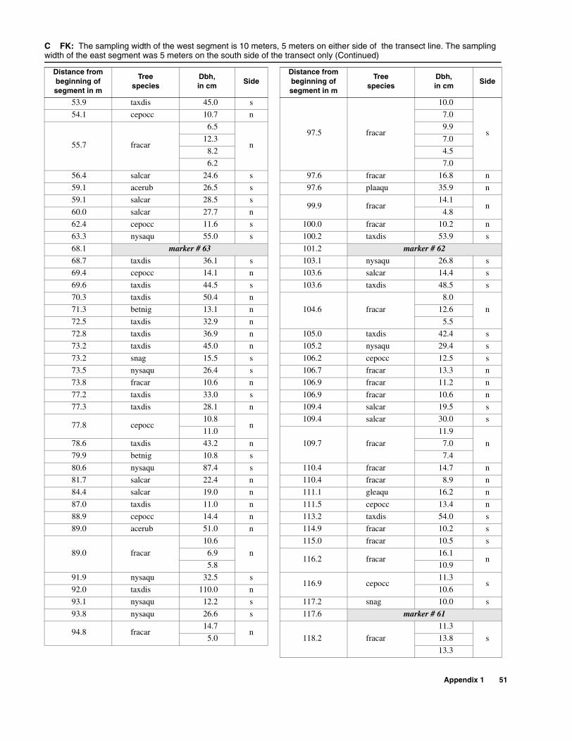
53.9 taxdis 45.0 s
97.5 fracar
10.0
s
54.1 cepocc 10.7 n 7.0
55.7 fracar
6.5
n
9.9
12.3 7.0
8.2 4.5
6.2 7.0
56.4 salcar 24.6 s 97.6 fracar 16.8 n
59.1 acerub 26.5 s 97.6 plaaqu 35.9 n
59.1 salcar 28.5 s99.9 fracar
14.1n
60.0 salcar 27.7 n 4.8
62.4 cepocc 11.6 s 100.0 fracar 10.2 n
63.3 nysaqu 55.0 s 100.2 taxdis 53.9 s
68.1 marker # 63 101.2 marker # 62
68.7 taxdis 36.1 s 103.1 nysaqu 26.8 s
69.4 cepocc 14.1 n 103.6 salcar 14.4 s
69.6 taxdis 44.5 s 103.6 taxdis 48.5 s
70.3 taxdis 50.4 n
104.6 fracar
8.0
n71.3 betnig 13.1 n 12.6
72.5 taxdis 32.9 n 5.5
72.8 taxdis 36.9 n 105.0 taxdis 42.4 s
73.2 taxdis 45.0 n 105.2 nysaqu 29.4 s
73.2 snag 15.5 s 106.2 cepocc 12.5 s
73.5 nysaqu 26.4 s 106.7 fracar 13.3 n
73.8 fracar 10.6 n 106.9 fracar 11.2 n
77.2 taxdis 33.0 s 106.9 fracar 10.6 n
77.3 taxdis 28.1 n 109.4 salcar 19.5 s
77.8 cepocc10.8
n109.4 salcar 30.0 s
11.0
109.7 fracar
11.9
n78.6 taxdis 43.2 n 7.0
79.9 betnig 10.8 s 7.4
80.6 nysaqu 87.4 s 110.4 fracar 14.7 n
81.7 salcar 22.4 n 110.4 fracar 8.9 n
84.4 salcar 19.0 n 111.1 gleaqu 16.2 n
87.0 taxdis 11.0 n 111.5 cepocc 13.4 n
88.9 cepocc 14.4 n 113.2 taxdis 54.0 s
89.0 acerub 51.0 n 114.9 fracar 10.2 s
89.0 fracar
10.6
n
115.0 fracar 10.5 s
6.9116.2 fracar
16.1n
5.8 10.9
91.9 nysaqu 32.5 s116.9 cepocc
11.3s
92.0 taxdis 110.0 n 10.6
93.1 nysaqu 12.2 s 117.2 snag 10.0 s
93.8 nysaqu 26.6 s 117.6 marker # 61
94.8 fracar14.7
n118.2 fracar
11.3
s5.0 13.8
13.3
C FK: The sampling width of the west segment is 10 meters, 5 meters on either side of the transect line. The sampling width of the east segment was 5 meters on the south side of the transect only (Continued)
Distance from beginning ofsegment in m
Treespecies
Dbh,in cm
SideDistance from beginning ofsegment in m
Treespecies
Dbh,in cm
Side
Appendix 1 51
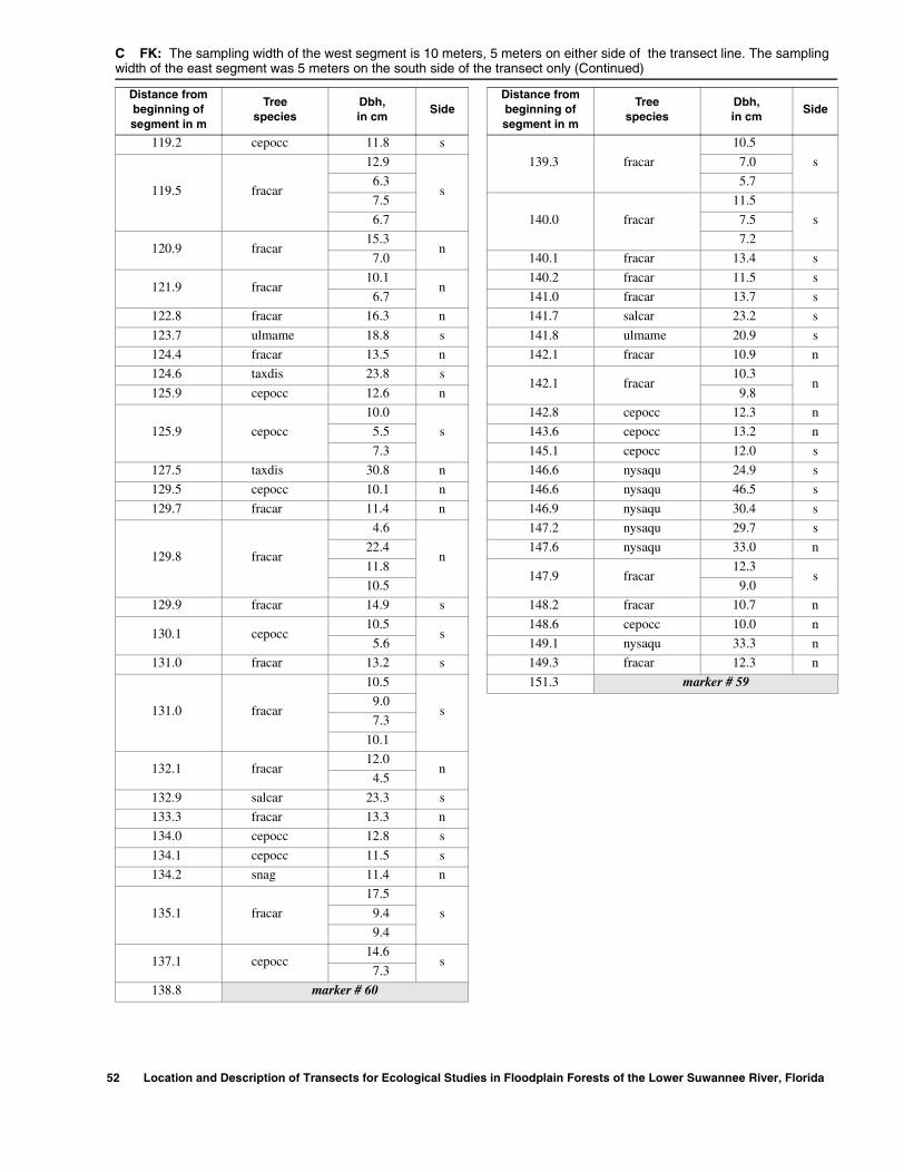
119.2 cepocc 11.8 s
139.3 fracar
10.5
s
119.5 fracar
12.9
s
7.0
6.3 5.7
7.5
140.0 fracar
11.5
s6.7 7.5
120.9 fracar15.3
n7.2
7.0 140.1 fracar 13.4 s
121.9 fracar10.1
n140.2 fracar 11.5 s
6.7 141.0 fracar 13.7 s
122.8 fracar 16.3 n 141.7 salcar 23.2 s
123.7 ulmame 18.8 s 141.8 ulmame 20.9 s
124.4 fracar 13.5 n 142.1 fracar 10.9 n
124.6 taxdis 23.8 s142.1 fracar
10.3n
125.9 cepocc 12.6 n 9.8
125.9 cepocc
10.0
s
142.8 cepocc 12.3 n
5.5 143.6 cepocc 13.2 n
7.3 145.1 cepocc 12.0 s
127.5 taxdis 30.8 n 146.6 nysaqu 24.9 s
129.5 cepocc 10.1 n 146.6 nysaqu 46.5 s
129.7 fracar 11.4 n 146.9 nysaqu 30.4 s
129.8 fracar
4.6
n
147.2 nysaqu 29.7 s
22.4 147.6 nysaqu 33.0 n
11.8147.9 fracar
12.3s
10.5 9.0
129.9 fracar 14.9 s 148.2 fracar 10.7 n
130.1 cepocc10.5
s148.6 cepocc 10.0 n
5.6 149.1 nysaqu 33.3 n
131.0 fracar 13.2 s 149.3 fracar 12.3 n
131.0 fracar
10.5
s
151.3 marker # 59
9.0
7.3
10.1
132.1 fracar12.0
n4.5
132.9 salcar 23.3 s
133.3 fracar 13.3 n
134.0 cepocc 12.8 s
134.1 cepocc 11.5 s
134.2 snag 11.4 n
135.1 fracar
17.5
s9.4
9.4
137.1 cepocc14.6
s7.3
138.8 marker # 60
C FK: The sampling width of the west segment is 10 meters, 5 meters on either side of the transect line. The sampling width of the east segment was 5 meters on the south side of the transect only (Continued)
Distance from beginning ofsegment in m
Treespecies
Dbh,in cm
SideDistance from beginning ofsegment in m
Treespecies
Dbh,in cm
Side
52 Location and Description of Transects for Ecological Studies in Floodplain Forests of the Lower Suwannee River, Florida
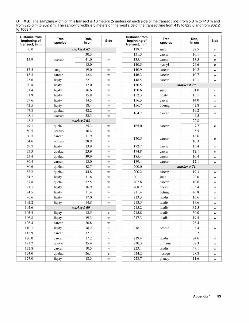
D MS: The sampling width of this transect is 10 meters (5 meters on each side of the transect line) from 5.3 m to 413 m and from 825.6 m to 902.2 m. The sampling width is 5 meters on the west side of the transect line from 413 to 825.6 and from 902.2 to 1003.7
Distance from beginning of transect, in m
Treespecies
Dbh,in cm Side
Distance from beginning of transect, in m
Treespecies
Dbh,in cm Side
0.0 marker # 67 128.7 snag 22.5 e
15.9 acerub30.5
w131.3 carcar 10.1 w
41.0 135.1 carcar 13.5 e13.0 140.5 nyssyl 24.6 e
17.5 snag 19.0 w 140.9 carcar 10.2 w18.3 carcar 12.4 w 146.3 carcar 10.7 w25.6 liqsty 22.1 w 148.5 carcar 12.1 w
30.8 liqsty 17.0 w 150.5 marker # 7031.4 liqsty 16.6 w 150.6 snag 81.0 e31.9 liqsty 15.8 w 152.3 liqsty 16.1 e39.6 liqsty 14.5 w 156.3 carcar 14.0 w42.5 liqsty 18.4 w 156.7 quenig 42.8 w47.8 quelau 42.2 w
164.7 carcar19.2
w48.1 acerub 32.3 w 4.548.2 marker # 68
165.0 carcar22.8
e49.1 quelau 25.3 w 7.750.5 acerub 10.4 w 5.560.7 carcar 11.9 w
170.5 carcar16.6
e64.6 acerub 28.9 w 10.3
69.7 liqsty 13.9 w 172.7 carcar 15.4 w73.3 quelau 23.9 w 174.8 carcar 12.1 e75.4 quelau 39.9 w 185.4 carcar 10.4 w80.4 carcar 13.0 w 189.4 carcar 12.1 w80.6 quelau 38.7 w 200.0 marker # 7182.2 quelau 44.8 w 200.2 carcar 19.3 w84.2 liqsty 11.8 w 201.7 snag 22.0 w87.8 quelau 52.5 w 207.8 carcar 10.6 w91.1 liqsty 16.9 w 208.2 quevir 35.4 w94.5 liqsty 11.4 w 211.4 betnig 40.8 w96.6 liqsty 17.0 w 213.3 taxdis 16.6 w
102.2 liqsty 14.8 w 213.3 taxdis 13.6 w102.6 marker # 69 215.2 taxdis 32.5 w105.4 liqsty 13.5 e 215.8 taxdis 30.0 w106.8 liqsty 19.3 w 217.3 taxdis 19.4 w108.4 carcar 20.8 w
218.1 acerub26.4
w110.1 liqsty 18.2 e 8.4
112.9 carcar 12.7 e 8.2120.0 carcar 17.2 w 219.4 taxdis 24.6 w121.2 quevir 35.4 w 220.3 ulmame 32.3 w122.8 carcar 10.5 w 223.1 taxdis 49.1 w124.0 quelau 26.1 e 224.2 nysaqu 28.8 w127.0 liqsty 18.3 w 228.7 plaaqu 11.6 w
Appendix 1 53

229.3 nysaqu 25.6 w 293.3 fracar 11.9 w
229.5 fracar
6.0
w
293.9 fracar 13.6 w12.3 296.0 fracar 10.2 w9.9 296.9 fracar 10.1 w7.0
297.3 fracar10.7
w9.9 7.4
238.1 marker # 72 299.0 nysaqu 34.7 w240.8 nysaqu 43.2 w 304.3 nysaqu 35.9 w
244.3 fracar14.0
w306.2 plaaqu
35.0w6.8 23.6
246.8 nysaqu 33.4 w 10.0
247.1 nysaqu33.9
w 309.5 fracar15.2
w36.2 10.6
247.7 fracar 10.1 w309.8 fracar
12.9w
252.3 cepocc10.4
w8.6
4.6 312.1 fracar 10.8 w
252.3 fracar
12.6
w
312.2 fracar 11.2 w
11.2312.8 plaaqu
20.4w
7.0 13.1253.2 betnig 18.0 w 313.6 plaaqu 20.6 w255.2 betnig 26.7 w 315.4 acerub 21.7 w
258.8 gleaqu36.9
w317.6 frapro 23.7 w
15.0 318.2 cepocc 10.3 w
259.2 nysaqu 48.8 w 318.5 frapro 20.6 w260.9 ulmame 25.9 w 319.7 nysaqu 36.4 w261.0 marker # 73 322.6 nysaqu 37.8 w
265.4 fracar
10.3
w
325.4 marker # 7510.0 326.6 plaaqu 16.3 w
5.5 329.2 snag 11.7 w8.4 330.2 taxdis 35.8 w
265.9 fracar
12.9
w
331.6 nysaqu 31.3 w7.7 333.9 taxdis 37.2 w
10.0 335.4 plaaqu 10.8 w8.7 336.2 fracar 10.1 w
10.4342.5 plaaqu
32.0w
8.0 6.6268.3 fracar 11.9 w 345.5 taxdis 35.9 w271.1 acerub 11.8 w 346.8 nysaqu 48.7 w272.7 nysaqu 38.6 w
348.1 fracar12.4
w276.6 nysaqu 38.5 w 9.2
280.9 acerub 55.0 w 350.1 taxdis 37.4 w283.2 taxdis 21.8 w 351.3 taxdis 20.5 w284.2 taxdis 53.0 w 351.8 taxdis 13.8 w284.3 plaaqu 18.6 w
352.6 plaaqu10.6
w286.4 taxdis 16.8 w 5.0287.7 acerub 22.3 w 352.9 gleaqu 22.3 w
291.5 marker # 74 356.4 frapro 49.2 w
D MS: The sampling width of this transect is 10 meters (5 meters on each side of the transect line) from 5.3 m to 413 m and from 825.6 m to 902.2 m. The sampling width is 5 meters on the west side of the transect line from 413 to 825.6 and from 902.2 to 1003.7 (Continued)
Distance from beginning of transect, in m
Treespecies
Dbh,in cm Side
Distance from beginning of transect, in m
Treespecies
Dbh,in cm Side
54 Location and Description of Transects for Ecological Studies in Floodplain Forests of the Lower Suwannee River, Florida
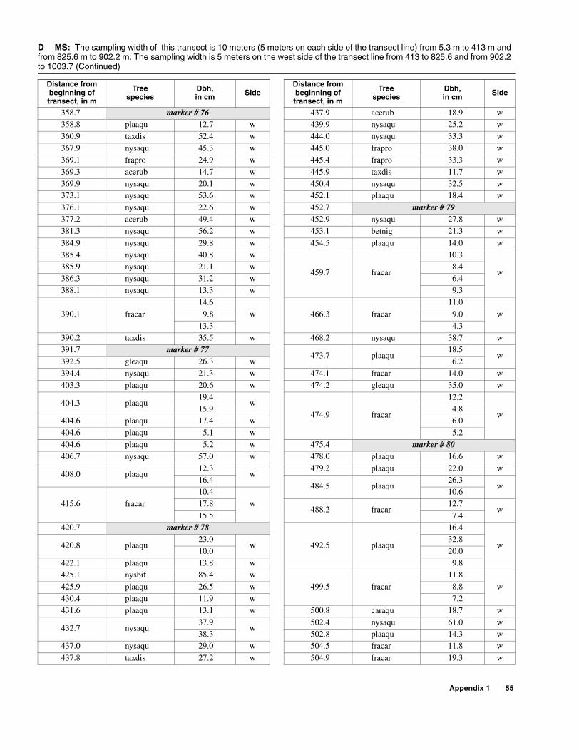
Appendix 1 55
358.7 marker # 76 437.9 acerub 18.9 w358.8 plaaqu 12.7 w 439.9 nysaqu 25.2 w360.9 taxdis 52.4 w 444.0 nysaqu 33.3 w367.9 nysaqu 45.3 w 445.0 frapro 38.0 w369.1 frapro 24.9 w 445.4 frapro 33.3 w
369.3 acerub 14.7 w 445.9 taxdis 11.7 w369.9 nysaqu 20.1 w 450.4 nysaqu 32.5 w373.1 nysaqu 53.6 w 452.1 plaaqu 18.4 w376.1 nysaqu 22.6 w 452.7 marker # 79377.2 acerub 49.4 w 452.9 nysaqu 27.8 w381.3 nysaqu 56.2 w 453.1 betnig 21.3 w
384.9 nysaqu 29.8 w 454.5 plaaqu 14.0 w385.4 nysaqu 40.8 w
459.7 fracar
10.3
w385.9 nysaqu 21.1 w 8.4386.3 nysaqu 31.2 w 6.4388.1 nysaqu 13.3 w 9.3
390.1 fracar
14.6
w 466.3 fracar
11.0
w9.8 9.013.3 4.3
390.2 taxdis 35.5 w 468.2 nysaqu 38.7 w391.7 marker # 77
473.7 plaaqu18.5
w392.5 gleaqu 26.3 w 6.2394.4 nysaqu 21.3 w 474.1 fracar 14.0 w
403.3 plaaqu 20.6 w 474.2 gleaqu 35.0 w
404.3 plaaqu19.4
w474.9 fracar
12.2
w15.9 4.8
404.6 plaaqu 17.4 w 6.0404.6 plaaqu 5.1 w 5.2
404.6 plaaqu 5.2 w 475.4 marker # 80406.7 nysaqu 57.0 w 478.0 plaaqu 16.6 w
408.0 plaaqu12.3
w479.2 plaaqu 22.0 w
16.4484.5 plaaqu
26.3w
415.6 fracar10.4
w10.6
17.8488.2 fracar
12.7w
15.5 7.4420.7 marker # 78
492.5 plaaqu
16.4
w420.8 plaaqu23.0
w32.8
10.0 20.0422.1 plaaqu 13.8 w 9.8425.1 nysbif 85.4 w
499.5 fracar
11.8
w425.9 plaaqu 26.5 w 8.8430.4 plaaqu 11.9 w 7.2431.6 plaaqu 13.1 w 500.8 caraqu 18.7 w
432.7 nysaqu37.9
w502.4 nysaqu 61.0 w
38.3 502.8 plaaqu 14.3 w437.0 nysaqu 29.0 w 504.5 fracar 11.8 w
437.8 taxdis 27.2 w 504.9 fracar 19.3 w
D MS: The sampling width of this transect is 10 meters (5 meters on each side of the transect line) from 5.3 m to 413 m and from 825.6 m to 902.2 m. The sampling width is 5 meters on the west side of the transect line from 413 to 825.6 and from 902.2 to 1003.7 (Continued)
Distance from beginning of transect, in m
Treespecies
Dbh,in cm Side
Distance from beginning of transect, in m
Treespecies
Dbh,in cm Side

56 Location and Description of Transects for Ecological Studies in Floodplain Forests of the Lower Suwannee River, Florida
511.0 nysaqu 17.2 w 587.7 marker # 83513.3 taxdis 44.0 w 593.2 betnig 40.4 w514.6 cepocc 16.4 w 594.0 betnig 11.1 e515.4 marker # 81 595.0 fracar 10.2 w
520.3 fracar
12.5
w
596.4 betnig 10.5 e
5.0 596.4 foracu 10.5 e10.3
601.8 fracar16.7
w5.7 8.95.4 4.1
11.8
604.2 fracar
10.0
w
521.2 fracar 18.1 w 8.9
523.5 fracar
11.2
w
8.76.1 7.37.9 9.05.5
608.3 fracar
10.0
w6.2 6.8
527.0 nysaqu 25.5 w 7.0
528.9 fracar
16.3
w
6.710.2 7.06.4 612.3 crafla 13.9 w9.2 613.5 diovir 24.2 w
529.7 fracar 15.5 w 614.1 fracar 21.0 w537.1 gleaqu 22.5 w 617.5 betnig 13.4 w
537.5 cepocc 11.0 w 619.7 caraqu 76.8 w538.1 betnig 34.4 w 621.1 crafla 22.3 w541.5 betnig 25.0 w
621.8 fracar12.5
e545.9 taxdis 46.3 w 8.3547.5 plaaqu 21.5 w 622.4 fracar 11.1 e
552.0 betnig 19.3 w 624.0 betnig 30.6 e552.2 betnig 13.0 w 625.6 betnig 28.6 w553.1 marker # 82 625.6 fracar 10.1 w554.0 betnig 15.5 w 627.4 liqsty 13.4 e557.9 betnig 22.1 w 628.5 betnig 17.5 e558.3 betnig 14.5 w 630.9 betnig 29.3 e
559.4 taxdis 29.9 w 631.2 fracar 10.5 w559.5 betnig 20.2 w
631.2 fracar
13.3
e
563.2 taxdis 16.7 w 8.9566.0 ulmame 31.0 w 5.7569.7 taxdis 26.2 w 8.6571.4 ulmame 31.8 w 6.4
571.6 betnig 40.4 w 6.7572.1 plaaqu 11.1 w
632.0 fracar13.0
w574.6 crafla 14.7 w 12.1579.8 taxdis 31.6 w 634.8 fracar 14.3 w580.4 betnig 16.0 w 635.1 gleaqu 42.7 e584.9 taxdis 20.9 w 635.1 taxdis 27.1 w
587.1 fracar 13.5 w 635.6 betnig 22.9 e
D MS: The sampling width of this transect is 10 meters (5 meters on each side of the transect line) from 5.3 m to 413 m and from 825.6 m to 902.2 m. The sampling width is 5 meters on the west side of the transect line from 413 to 825.6 and from 902.2 to 1003.7 (Continued)
Distance from beginning of transect, in m
Treespecies
Dbh,in cm Side
Distance from beginning of transect, in m
Treespecies
Dbh,in cm Side

639.2 marker # 84 678.2 fracar 13.1 w639.3 betnig 25.5 w 680.2 fracar 10.0 e
639.9 fracar11.5
w 680.3 plaaqu13.2
w7.6 4.9
640.3 fracar 13.1 w680.5 fracar
10.6e
640.4 betnig 14.0 w 7.9640.6 betnig 20.7 e
680.6 plaaqu35.5
w642.8 plaaqu 17.3 w 16.4644.3 fracar 10.5 w
681.7 plaaqu16.4
w647.1 taxdis 78.3 w 15.0648.0 fracar 13.1 e 685.6 plaaqu 11.5 e
649.7 plaaqu 11.5 w686.0 plaaqu
35.5e
649.9 plaaqu 17.8 w 30.6650.6 betnig 29.0 w 686.0 taxdis 19.4 w651.7 nysaqu 35.0 e 688.6 fracar 10.2 w
654.1 fracar12.0
w689.6 fracar 13.1 w
8.5689.9 fracar
10.0e
656.7 fracar 10.5 e 8.0656.7 taxdis 11.9 w 691.2 gleaqu 48.0 w657.0 fracar 10.1 e 692.0 nysaqu 35.7 w657.5 fracar 10.5 w 692.3 fracar 10.0 e658.0 fracar 10.8 w 693.2 nysaqu 42.0 e660.0 nysaqu 32.0 w 693.3 fracar 10.2 w
661.8 fracar 15.2 w693.4 betnig
19.2w
662.4 quelau 33.0 e 24.3662.7 ulmame 17.0 e 693.8 plaaqu 10.8 w
665.4 plaaqu51.0
e694.2 plaaqu 15.3 e
5.6 695.2 nysaqu 18.6 w
665.5 taxdis 32.0 w 697.6 fracar 12.4 e667.7 fracar 10.5 w 698.7 nysaqu 35.0 w668.9 fracar 13.4 w 699.1 plaaqu 11.0 w
670.6 fracar15.0
w699.4 plaaqu 16.0 w
7.1 699.5 fracar 13.2 e8.7 699.7 fracar 11.1 e
670.7 betnig 12.2 w699.7
fracar10.0 e
671.1 fracar12.7
wfracar
14.0 fracar673.6 cepocc 7.6 w 701.5 plaaqu 19.6 e674.6 cepocc 10.0 w 702.9 acerub 18.4 w
674.9 plaaqu36.0
w703.2 gleaqu 26.7 e
11.1 703.2 plaaqu 17.2 e675.4 fracar 10.2 e
703.7 plaaqu31.4
w676.2 fracar 11.1 e 21.2676.2 marker # 85
703.8 plaaqu16.7
w676.7 betnig 26.0 e 10.6676.8 acerub 11.6 w 703.9 gleaqu 18.0 e
678.0 cepocc 11.1 w 704.0 marker # 86
D MS: The sampling width of this transect is 10 meters (5 meters on each side of the transect line) from 5.3 m to 413 m and from 825.6 m to 902.2 m. The sampling width is 5 meters on the west side of the transect line from 413 to 825.6 and from 902.2 to 1003.7 (Continued)
Distance from beginning of transect, in m
Treespecies
Dbh,in cm Side
Distance from beginning of transect, in m
Treespecies
Dbh,in cm Side
Appendix 1 57
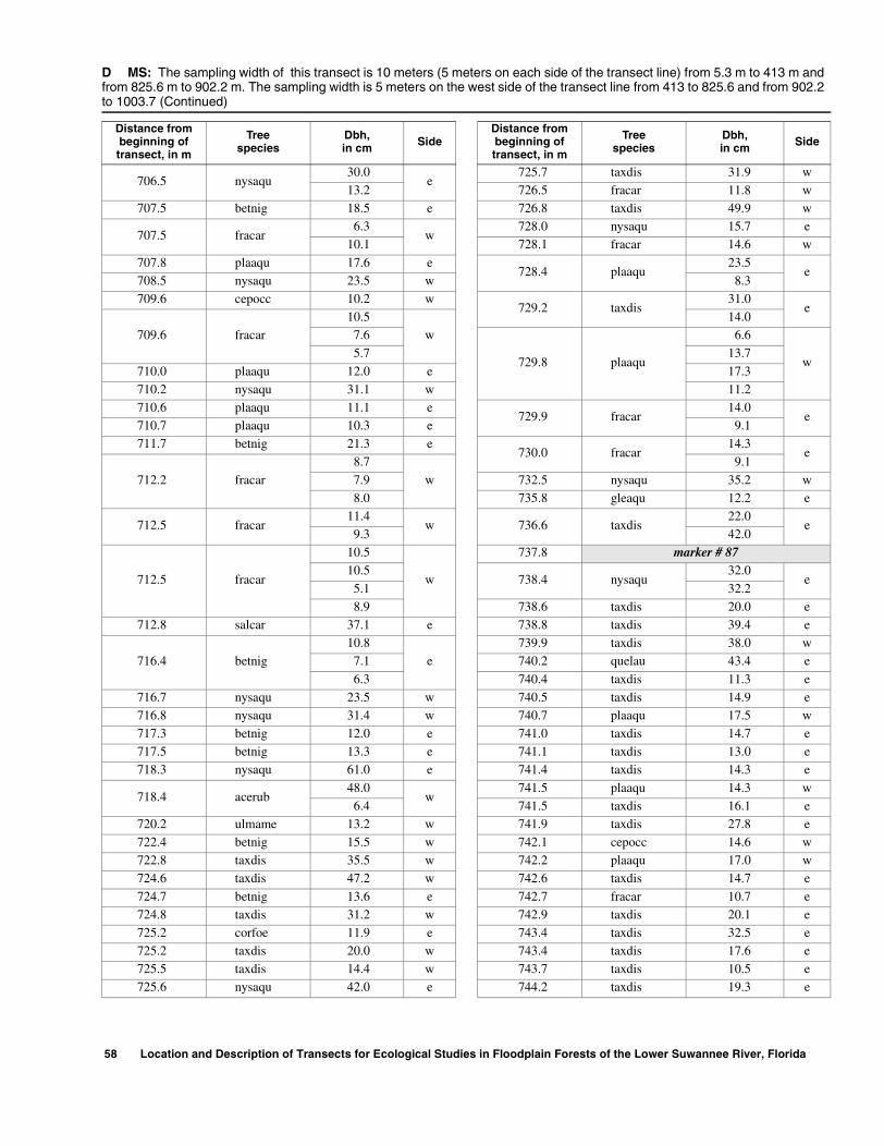
706.5 nysaqu30.0
e725.7 taxdis 31.9 w
13.2 726.5 fracar 11.8 w707.5 betnig 18.5 e 726.8 taxdis 49.9 w
707.5 fracar6.3
w728.0 nysaqu 15.7 e
10.1 728.1 fracar 14.6 w
707.8 plaaqu 17.6 e728.4 plaaqu
23.5e
708.5 nysaqu 23.5 w 8.3709.6 cepocc 10.2 w
729.2 taxdis31.0
e
709.6 fracar10.5
w14.0
7.6
729.8 plaaqu
6.6
w5.7 13.7
710.0 plaaqu 12.0 e 17.3710.2 nysaqu 31.1 w 11.2710.6 plaaqu 11.1 e
729.9 fracar14.0
e710.7 plaaqu 10.3 e 9.1711.7 betnig 21.3 e
730.0 fracar14.3
e
712.2 fracar
8.7
w
9.1
7.9 732.5 nysaqu 35.2 w8.0 735.8 gleaqu 12.2 e
712.5 fracar11.4
w 736.6 taxdis22.0
e9.3 42.0
712.5 fracar
10.5
w
737.8 marker # 8710.5
738.4 nysaqu32.0
e5.1 32.28.9 738.6 taxdis 20.0 e
712.8 salcar 37.1 e 738.8 taxdis 39.4 e
716.4 betnig10.8
e739.9 taxdis 38.0 w
7.1 740.2 quelau 43.4 e
6.3 740.4 taxdis 11.3 e716.7 nysaqu 23.5 w 740.5 taxdis 14.9 e716.8 nysaqu 31.4 w 740.7 plaaqu 17.5 w717.3 betnig 12.0 e 741.0 taxdis 14.7 e717.5 betnig 13.3 e 741.1 taxdis 13.0 e718.3 nysaqu 61.0 e 741.4 taxdis 14.3 e
718.4 acerub48.0
w741.5 plaaqu 14.3 w
6.4 741.5 taxdis 16.1 e720.2 ulmame 13.2 w 741.9 taxdis 27.8 e722.4 betnig 15.5 w 742.1 cepocc 14.6 w722.8 taxdis 35.5 w 742.2 plaaqu 17.0 w724.6 taxdis 47.2 w 742.6 taxdis 14.7 e
724.7 betnig 13.6 e 742.7 fracar 10.7 e724.8 taxdis 31.2 w 742.9 taxdis 20.1 e725.2 corfoe 11.9 e 743.4 taxdis 32.5 e725.2 taxdis 20.0 w 743.4 taxdis 17.6 e725.5 taxdis 14.4 w 743.7 taxdis 10.5 e725.6 nysaqu 42.0 e 744.2 taxdis 19.3 e
D MS: The sampling width of this transect is 10 meters (5 meters on each side of the transect line) from 5.3 m to 413 m and from 825.6 m to 902.2 m. The sampling width is 5 meters on the west side of the transect line from 413 to 825.6 and from 902.2 to 1003.7 (Continued)
Distance from beginning of transect, in m
Treespecies
Dbh,in cm Side
Distance from beginning of transect, in m
Treespecies
Dbh,in cm Side
58 Location and Description of Transects for Ecological Studies in Floodplain Forests of the Lower Suwannee River, Florida
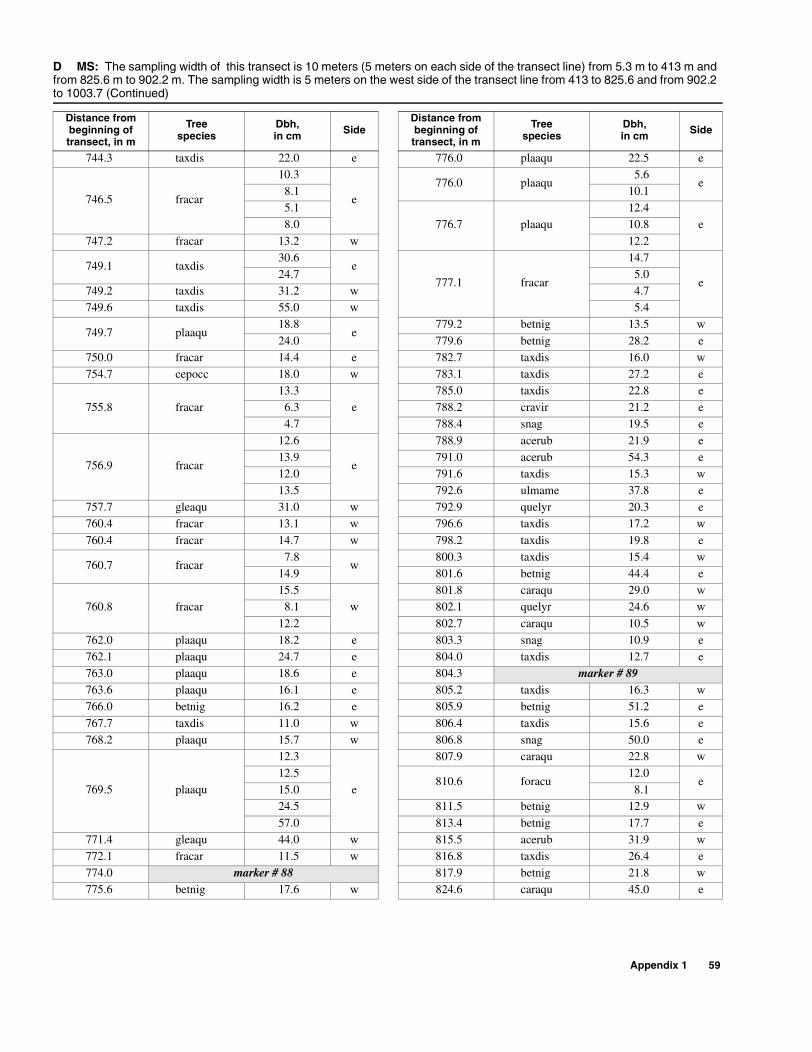
744.3 taxdis 22.0 e 776.0 plaaqu 22.5 e
746.5 fracar
10.3
e776.0 plaaqu
5.6e
8.1 10.15.1
776.7 plaaqu12.4
e8.0 10.8
747.2 fracar 13.2 w 12.2
749.1 taxdis30.6
e777.1 fracar
14.7
e24.7 5.0
749.2 taxdis 31.2 w 4.7749.6 taxdis 55.0 w 5.4
749.7 plaaqu18.8
e779.2 betnig 13.5 w
24.0 779.6 betnig 28.2 e750.0 fracar 14.4 e 782.7 taxdis 16.0 w754.7 cepocc 18.0 w 783.1 taxdis 27.2 e
755.8 fracar13.3
e785.0 taxdis 22.8 e
6.3 788.2 cravir 21.2 e4.7 788.4 snag 19.5 e
756.9 fracar
12.6
e
788.9 acerub 21.9 e13.9 791.0 acerub 54.3 e12.0 791.6 taxdis 15.3 w13.5 792.6 ulmame 37.8 e
757.7 gleaqu 31.0 w 792.9 quelyr 20.3 e760.4 fracar 13.1 w 796.6 taxdis 17.2 w
760.4 fracar 14.7 w 798.2 taxdis 19.8 e
760.7 fracar7.8
w800.3 taxdis 15.4 w
14.9 801.6 betnig 44.4 e
760.8 fracar15.5
w801.8 caraqu 29.0 w
8.1 802.1 quelyr 24.6 w
12.2 802.7 caraqu 10.5 w762.0 plaaqu 18.2 e 803.3 snag 10.9 e762.1 plaaqu 24.7 e 804.0 taxdis 12.7 e763.0 plaaqu 18.6 e 804.3 marker # 89763.6 plaaqu 16.1 e 805.2 taxdis 16.3 w766.0 betnig 16.2 e 805.9 betnig 51.2 e
767.7 taxdis 11.0 w 806.4 taxdis 15.6 e768.2 plaaqu 15.7 w 806.8 snag 50.0 e
769.5 plaaqu
12.3
e
807.9 caraqu 22.8 w12.5
810.6 foracu12.0
e15.0 8.124.5 811.5 betnig 12.9 w
57.0 813.4 betnig 17.7 e771.4 gleaqu 44.0 w 815.5 acerub 31.9 w772.1 fracar 11.5 w 816.8 taxdis 26.4 e774.0 marker # 88 817.9 betnig 21.8 w775.6 betnig 17.6 w 824.6 caraqu 45.0 e
D MS: The sampling width of this transect is 10 meters (5 meters on each side of the transect line) from 5.3 m to 413 m and from 825.6 m to 902.2 m. The sampling width is 5 meters on the west side of the transect line from 413 to 825.6 and from 902.2 to 1003.7 (Continued)
Distance from beginning of transect, in m
Treespecies
Dbh,in cm Side
Distance from beginning of transect, in m
Treespecies
Dbh,in cm Side
Appendix 1 59

826.3 betnig 18.7 w 924.2 betnig 50.8 w
828.0 foracu9.7
w928.7 taxdis 15.7 e
11.9929.8 fracar
11.1w830.6 ulmame 15.0 w 11.0
831.4 ulmame 11.9 w 9.5
839.5 caraqu 43.1 w930.1 fracar
11.0w
842.2 acerub 13.5 w 16.6845.0 marker # 90 930.1 fracar 5.5 w
845.8 cravir11.2
w930.6 fracar
12.4
w11.3 10.5
845.8 cravir 6.9 w 11.2
846.3 caraqu 38.4 w 13.2850.5 quelyr 46.4 e 931.8 liqsty 10.0 e854.9 cravir 16.8 e 935.0 plaaqu 30.0 e862.1 taxdis 10.2 e 936.1 taxdis 32.7 w863.9 caraqu 33.7 w 937.5 plaaqu 24.1 e864.1 cellae 22.7 w 938.3 plaaqu 25.4 w
866.7 betnig 37.5 e 938.4 cepocc 10.7 e867.7 caraqu 50.0 e
942.7 fracar
10.3
e
870.3 caraqu 34.4 w 9.3873.1 betnig 10.7 e 5.0873.7 betnig 16.2 w 8.0
877.0 carcar10.2
w7.4
14.0 13.8883.7 betnig 15.7 w 7.4883.8 betnig 17.2 e 9.2886.5 betnig 15.8 w 946.1 fracar 17.4 e889.3 betnig 22.9 e 946.3 snag 11.4 e
889.5 marker # 91 946.4 gleaqu 38.4 e889.8 liqsty 24.1 e 947.0 gleaqu 13.0 e890.1 betnig 13.0 w 948.0 gleaqu 15.0 e891.5 betnig 18.9 w
950.6 plaaqu27.9
w891.5 betnig 15.6 e 35.6893.5 betnig 10.7 e 954.6 nysaqu 21.5 e
894.5 betnig 23.7 w 955.4 plaaqu 37.5 w894.9 betnig 18.3 w 956.4 gleaqu 15.1 e896.3 betnig 10.0 w 956.4 taxdis 15.6 e897.7 betnig 11.9 w 956.8 taxdis 49.0 w897.7 betnig 10.3 e 959.0 taxdis 53.8 w899.0 caraqu 34.0 e
959.9 fracar12.7
w900.4 betnig 12.9 e 6.5900.8 betnig 31.8 w 959.9 taxdis 35.0 w902.2 betnig 12.4 e 960.1 plaaqu 17.3 w903.4 betnig 15.7 w 960.5 taxdis 55.5 e916.4 snag 30.6 e 964.9 plaaqu 16.0 w917.4 marker # 92 965.4 plaaqu 21.0 w
918.6 snag 69.0 e 966.4 nysaqu 63.0 e
D MS: The sampling width of this transect is 10 meters (5 meters on each side of the transect line) from 5.3 m to 413 m and from 825.6 m to 902.2 m. The sampling width is 5 meters on the west side of the transect line from 413 to 825.6 and from 902.2 to 1003.7 (Continued)
Distance from beginning of transect, in m
Treespecies
Dbh,in cm Side
Distance from beginning of transect, in m
Treespecies
Dbh,in cm Side
60 Location and Description of Transects for Ecological Studies in Floodplain Forests of the Lower Suwannee River, Florida

D MS: The sampling width of this transect is 10 meters (5 meters on each side of the transect line) from 5.3 m to 413 m and from 825.6 m to 902.2 m. The sampling width is 5 meters on the west side of the transect line from 413 to 825.6 and from 902.2 to 1003.7 (Continued)
Distance from beginning of transect, in m
Treespecies
Dbh,in cm
Side
967.9 nysaqu 45.9 w
969.5 nysaqu 28.2 e
969.9 gleaqu 34.8 w
970.0 taxdis 53.6 w
970.1 marker # 93
972.0 taxdis 63.8 w
972.2 snag 37.0 e
976.1 quelyr 61.1 e
980.6 caraqu 61.2 w
980.8 quelyr 67.0 e
984.0 quelyr 44.5 w
985.0 ulmame 26.4 w
994.0 snag 53.9 w
1000.2 ulmame 20.2 w
1002.9 ulmame 13.4 w
1003.7 marker # 94
1004.9 snag 36.1 w
1005.3 quelau 60.0 e
1007.5 ulmame 26.0 e
Appendix 1 61

E KN: The sampling width of this transect is 5 meters (on the north side of the transect line) from -3.1 to 721.5 and 10 meters (5 meters on either side of the transect line) from 721.5 to 729.3
Distance from beginning of transect, in m
Treespecies
Dbh,in cm
SideDistance from beginning of transect, in m
Treespecies
Dbh,in cm
Side
0 marker # 95 64.9 frapro 21.9 n
3.9 liqsty 10.0 n 65.8 plaaqu 12.0 n4.2 betnig 18.9 n 65.8 plaaqu 12.0 n
6.2 liqsty10.5
n69.3 nysaqu 56.4 n
6.5 70.2 marker # 987.9 taxdis 33.0 n 76.8 nysaqu 51.3 n
10.8 betnig 12.6 n 79.7 nysaqu 36.4 n
11.5 betnig 13.0 n 79.9 taxdis 19.2 n12.4 betnig 10.0 n
82.0 frapro30.3
n14.6 betnig 10.0 n 27.917.4 taxdis 37.3 n 83.0 snag 17.5 n18.5 taxdis 17.4 n 85.1 nysaqu 42.0 n
22.4 betnig15.7
n85.7 nysaqu 16.2 n
7.0 91.2 frapro 25.0 n25.1 taxdis 11.4 n 91.6 nysaqu 25.8 n25.2 marker # 96 93.5 nysaqu 30.4 n27.7 betnig 12.3 n 96.0 nysaqu 59.3 n
28.7 betnig8.9
n97.2 marker # 99
11.2 99.7 fracar 13.5 n
30.4 liqsty 10.2 n 100.3 nysaqu 41.6 n32.3 betnig 18.8 n 102.8 taxdis 27.0 n34.1 taxdis 35.4 n 105.8 plaaqu 12.5 n35.5 taxdis 35.4 n
108.3 plaaqu
12.8
n
37.3 liqsty 12.3 n 11.1
39.2 betnig 20.0 n 11.5
41.2 gleaqu10.0
n13.8
6.5 16.05.0 110.3 fracar 10.9 n
45.6 plaaqu 22.4 n 115.2 plaaqu 19.5 n50.7 taxdis 13.4 n 117.9 marker # 10051.6 marker # 97 118.5 plaaqu 17.9 n
52.5 salcar13.3
n122.1 plaaqu 20.0 n
8.7 127.9 frapro 43.0 n52.6 salcar 15.4 n 129.8 liqsty 19.0 n52.6 salcar 11.0 n 132.0 fracar 10.0 n54.0 fracar 12.5 n 132.5 taxdis 31.2 n
55.9 plaaqu 16.5 n 134.9 taxdis 10.6 n59.8 taxdis 32.6 n 135.3 nysaqu 48.9 n60.8 taxdis 32.7 n 136.4 nysaqu 24.6 n
61.0 fracar10.5
n136.7 taxdis 25.3 n
4.3 138.1 taxdis 26.4 n61.2 nysaqu 26.5 n 138.8 plaaqu 27.0 n
61.5 fracar14.5
n139.1 marker # 101
5.0 140.5 nysaqu 22.1 n6.0
62 Location and Description of Transects for Ecological Studies in Floodplain Forests of the Lower Suwannee River, Florida

150.8 fracar10.6
n230.4 nysaqu 32.0 n
9.5 234.6 nysaqu 31.8 n150.9 taxdis 39.6 n 234.6 nysaqu 17.9 n154.7 nysaqu 50.1 n 237.8 nysaqu 61.9 n156.9 plaaqu 30.4 n 240.9 nysaqu 12.3 n160.3 marker # 102 241.4 nysaqu 21.4 n160.5 nysaqu 56.8 n 241.4 nysaqu 23.1 n
163.5 plaaqu 10.9 n 242.2 taxdis 39.0 n
167.6 plaaqu11.3
n242.4 nysaqu 38.0 n
9.1 242.5 nysaqu 44.4 n9.2 242.8 nysaqu 16.7 n
168.5 acerub 27.9 n 243.8 nysaqu 25.8 n
170.4 fracar10.7
n246.2 taxdis 13.8 n
6.8 247.2 taxdis 23.3 n
170.7 fracar14.3
n248.1 taxdis 40.4 n
11.7 250.4 taxdis 41.5 n172.3 fracar 10.0 n 257.1 nysaqu 35.3 n178.5 taxdis 31.0 n 257.5 taxdis 39.6 n179.1 taxdis 38.8 n 260.0 nysaqu 16.9 n
180.7 taxdis39.4
n260.1 taxdis 46.0 n
28.4 265.2 marker # 105182.6 snag 24.7 n
265.7 nysaqu48.5
n
184.7plaaqu
22.9 n39.2
plaaqu 269.0 taxdis 43.0 n
plaaqu273.3 fracar
15.2n
184.7 taxdis 13.0 n 5.0186.8 taxdis 45.9 n 273.7 snag 12.5 n188.2 fracar 11.0 n 277.5 ulmame 26.9 n190.8 marker # 103 281.2 taxdis 23.4 n191.5 acerub 27.4 n
282.8 plaaqu
16.7
n192.3 liqsty 44.1 n 14.8192.4 taxdis 17.4 n 9.0200.8 nysaqu 52.5 n 6.0202.3 taxdis 38.0 n 16.9206.2 fracar 10.6 n 283.3 ulmame 30.3 n206.5 fracar 10.1 n 290.3 betnig 15.5 n
208.3 nysaqu 53.3 n 290.2 marker # 106208.7 snag 19.7 n 295.9 caraqu 60.6 n
212.3 plaaqu30.5
n302.6 quelau 65.9 n
6.5 306.0 taxdis 16.9 n212.6 nysaqu 58.6 n 306.1 quelau 21.4 n214.0 fracar 10.3 n 308.1 cravir 13.5 n
214.0 fracar 9.4 n 314.9 cravir 11.8 n216.0 taxdis 65.5 n 315.4 caraqu 14.8 n218.3 plaaqu 17.5 n 316.2 quelau 35.8 n219.2 nysaqu 14.6 n 321.5 liqsty 33.4 n221.7 marker # 104 322.4 carcar 16.5 n
E KN: The sampling width of this transect is 5 meters (on the north side of the transect line) from -3.1 to 721.5 and 10 meters (5 meters on either side of the transect line) from 721.5 to 729.3 (Continued)
Distance from beginning of transect, in m
Treespecies
Dbh,in cm
SideDistance from beginning of transect, in m
Treespecies
Dbh,in cm
Side
Appendix 1 63

322.6 marker # 107 405.8 taxdis 24.3 n
322.6 liqsty45.3
n406.9 taxdis 21.9 n
37.4 407.0 taxdis 30.8 n323.0 liqsty 19.9 n 407.1 taxdis 17.2 n325.8 taxdis 14.4 n 407.6 marker # 110327.5 betnig 14.7 n 408.1 taxdis 30.3 n334.7 plaaqu 22.0 n 408.1 taxdis 20.5 n
335.2 plaaqu 14.1 n 408.6 taxdis 43.5 n335.5 nysaqu 25.8 n 411.7 taxdis 25.2 n339.5 nysaqu 44.0 n 413.5 taxdis 14.3 n343.6 fracar 10.5 n 413.6 taxdis 31.5 n344.5 fracar 11.9 n 414.1 taxdis 21.5 n344.9 snag 10.4 n
415.8 fracar
10.9
n345.7 cepocc 10.1 n 6.3348.5 marker # 108 8.6349.5 taxdis 53.6 n 415.8 taxdis 24.3 n349.7 nysaqu 12.8 n 416.4 taxdis 31.5 n353.4 taxdis 22.3 n 416.8 fracar 11.0 n
357.3 plaaqu22.5
n417.4 taxdis 30.0 n
8.6 417.6 taxdis 46.9 n358.5 plaaqu 23.5 n 419.2 snag 10.3 n360.9 frapro 39.9 n 420.1 fracar 10.9 n361.5 fracar 20.8 n 420.4 fracar 10.7 n361.5 fracar 16.2 n 422.5 plaaqu 21.9 n
370.0 nysaqu45.0
n422.9 liqsty 17.8 n
22.7423.2 fracar
12.0n
371.6 nysaqu 51.0 n 4.5373.4 nysbif 51.5 n 425.9 frapro 40.8 n373.8 plaaqu 16.4 n 426.3 plaaqu 10.8 n376.2 taxdis 54.8 n 428.0 ulmame 11.0 n
382.8 frapro 23.7 n 431.3 marker # 111383.3 marker # 109
437.0 fracar13.1
n383.3 nysaqu 32.4 n 4.8383.3 nysaqu 40.3 n 8.8389.6 taxdis 40.5 n 438.4 snag 11.0 n390.8 taxdis 45.9 n 439.7 ilecas 11.3 n
390.9 taxdis 26.5 n 440.2 taxdis 39.4 n391.3 liqsty 16.5 n 442.8 nysaqu 49.7 n392.2 plaaqu 10.1 n 444.4 taxdis 34.9 n394.8 taxdis 30.8 n 445.6 taxdis 24.6 n396.4 taxdis 31.2 n 447.0 taxdis 45.2 n397.6 fracar 10.5 n 452.3 nysaqu 36.2 n
399.6 taxdis 23.5 n 452.6 marker # 112400.9 nysaqu 54.7 n 453.6 nysaqu 40.3 n401.5 taxdis 18.1 n 453.9 nysaqu 44.4 n403.6 taxdis 34.0 n 453.9 snag 17.1 n404.5 nysaqu 43.6 n 455.6 nysaqu 40.8 n
E KN: The sampling width of this transect is 5 meters (on the north side of the transect line) from -3.1 to 721.5 and 10 meters (5 meters on either side of the transect line) from 721.5 to 729.3 (Continued)
Distance from beginning of transect, in m
Treespecies
Dbh,in cm
SideDistance from beginning of transect, in m
Treespecies
Dbh,in cm
Side
64 Location and Description of Transects for Ecological Studies in Floodplain Forests of the Lower Suwannee River, Florida
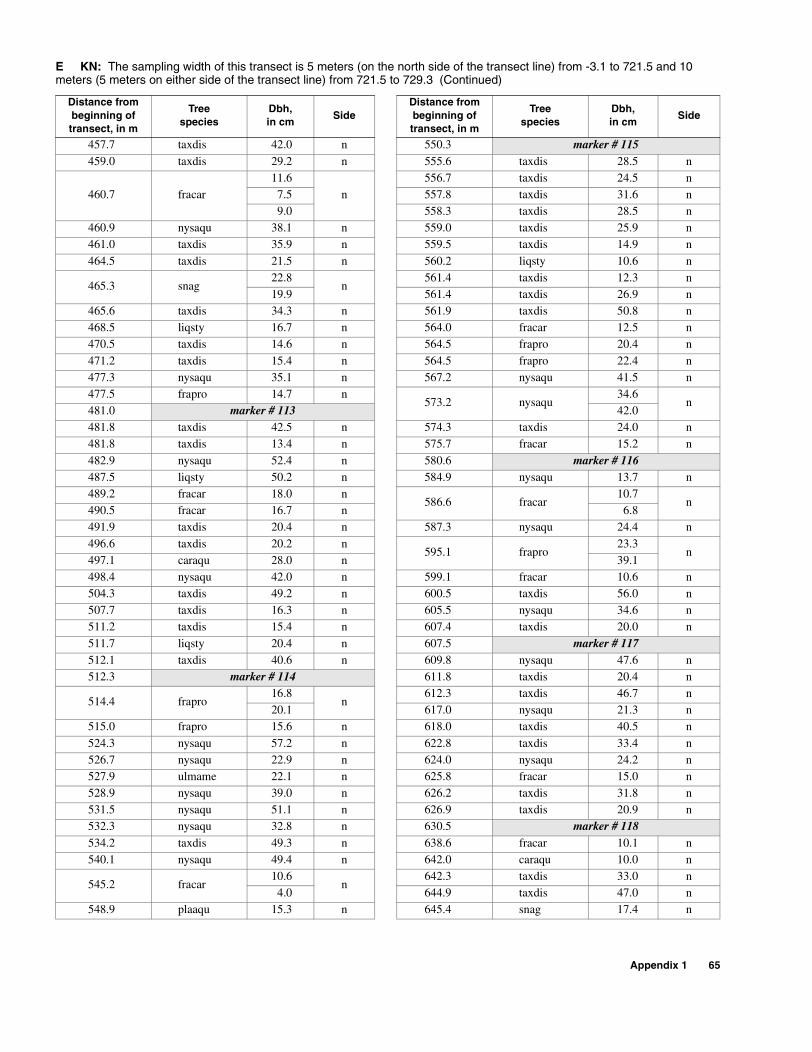
457.7 taxdis 42.0 n 550.3 marker # 115459.0 taxdis 29.2 n 555.6 taxdis 28.5 n
460.7 fracar11.6
n556.7 taxdis 24.5 n
7.5 557.8 taxdis 31.6 n9.0 558.3 taxdis 28.5 n
460.9 nysaqu 38.1 n 559.0 taxdis 25.9 n461.0 taxdis 35.9 n 559.5 taxdis 14.9 n
464.5 taxdis 21.5 n 560.2 liqsty 10.6 n
465.3 snag22.8
n561.4 taxdis 12.3 n
19.9 561.4 taxdis 26.9 n465.6 taxdis 34.3 n 561.9 taxdis 50.8 n468.5 liqsty 16.7 n 564.0 fracar 12.5 n470.5 taxdis 14.6 n 564.5 frapro 20.4 n
471.2 taxdis 15.4 n 564.5 frapro 22.4 n477.3 nysaqu 35.1 n 567.2 nysaqu 41.5 n477.5 frapro 14.7 n
573.2 nysaqu34.6
n481.0 marker # 113 42.0481.8 taxdis 42.5 n 574.3 taxdis 24.0 n481.8 taxdis 13.4 n 575.7 fracar 15.2 n
482.9 nysaqu 52.4 n 580.6 marker # 116487.5 liqsty 50.2 n 584.9 nysaqu 13.7 n489.2 fracar 18.0 n
586.6 fracar10.7
n490.5 fracar 16.7 n 6.8491.9 taxdis 20.4 n 587.3 nysaqu 24.4 n
496.6 taxdis 20.2 n595.1 frapro
23.3n
497.1 caraqu 28.0 n 39.1498.4 nysaqu 42.0 n 599.1 fracar 10.6 n504.3 taxdis 49.2 n 600.5 taxdis 56.0 n507.7 taxdis 16.3 n 605.5 nysaqu 34.6 n511.2 taxdis 15.4 n 607.4 taxdis 20.0 n
511.7 liqsty 20.4 n 607.5 marker # 117512.1 taxdis 40.6 n 609.8 nysaqu 47.6 n512.3 marker # 114 611.8 taxdis 20.4 n
514.4 frapro16.8
n612.3 taxdis 46.7 n
20.1 617.0 nysaqu 21.3 n515.0 frapro 15.6 n 618.0 taxdis 40.5 n
524.3 nysaqu 57.2 n 622.8 taxdis 33.4 n526.7 nysaqu 22.9 n 624.0 nysaqu 24.2 n527.9 ulmame 22.1 n 625.8 fracar 15.0 n528.9 nysaqu 39.0 n 626.2 taxdis 31.8 n531.5 nysaqu 51.1 n 626.9 taxdis 20.9 n532.3 nysaqu 32.8 n 630.5 marker # 118534.2 taxdis 49.3 n 638.6 fracar 10.1 n540.1 nysaqu 49.4 n 642.0 caraqu 10.0 n
545.2 fracar10.6
n642.3 taxdis 33.0 n
4.0 644.9 taxdis 47.0 n548.9 plaaqu 15.3 n 645.4 snag 17.4 n
E KN: The sampling width of this transect is 5 meters (on the north side of the transect line) from -3.1 to 721.5 and 10 meters (5 meters on either side of the transect line) from 721.5 to 729.3 (Continued)
Distance from beginning of transect, in m
Treespecies
Dbh,in cm
SideDistance from beginning of transect, in m
Treespecies
Dbh,in cm
Side
Appendix 1 65

645.7 frapro 23.4 n 732.4 caraqu 52.6 s
647.4fracar
14.5 n
733.6 acerub
37.4
nfracar 22.2
647.9 taxdis 27.4 n 7.6650.3 taxdis 24.4 n 16.5652.7 nysaqu 57.3 n 5.9653.8 marker # 119 733.9 nysaqu 54.2 n
656.7 taxdis 41.3 n662.1 taxdis 26.4 n664.0 nysaqu 43.5 n
666.2 fracar15.8
n6.4
667.5 fracar 11.3 n
672.8 fracar
9.1
n5.5
12.28.57.0
673.1 fracar 13.2 n
679.2 marker # 120682.1 plaaqu 12.3 n685.3 plaaqu 13.3 n687.8 frapro 37.4 n688.7 frapro 14.3 n
689.7 ulmame 10.0 n691.8 taxdis 91.4 n693.0 nysaqu 61.8 n694.2 fracar 14.0 n698.4 taxdis 30.4 n698.8 taxdis 28.7 n
727.7 fracar
11.4
s
6.212.6
9.04.38.3
8.410.2
729.3 marker # 121731.3 betnig 32.1 n731.4 frapro 48.3 s
732.3 fracar12.7
n6.0
732.3 taxdis 52.4 n
732.4 fracar13.7
n11.3
E KN: The sampling width of this transect is 5 meters (on the north side of the transect line) from -3.1 to 721.5 and 10 meters (5 meters on either side of the transect line) from 721.5 to 729.3 (Continued)
Distance from beginning of transect, in m
Treespecies
Dbh,in cm
SideDistance from beginning of transect, in m
Treespecies
Dbh,in cm
Side
66 Location and Description of Transects for Ecological Studies in Floodplain Forests of the Lower Suwannee River, Florida

F KI: The sampling width of this transect is 10 meters (5 meters on either side of the transect line).
Distance from beginning of transect, in m
Treespecies
Dbh,in cm
Side
0.0 marker # 122
3.6 liqsty 47.2 w
7.9 quelau 54.0 w
9.6 quelau 24.6 w
11.4 liqsty 32.5 e
16.9 caraqu 23.2 w
17.8 carcar 11.4 e
22.8 betnig37.8
w6.3
24.2 betnig18.6
w9.5
26.9 betnig 21.0 w
26.9 sabpal 19.3 w
28.4 sabpal 26.8 e
36.9 marker # 123
39.6 betnig 18.4 w
40.1 sabpal 26.8 w
41.4 carcar 14.9 e
43.3 carcar 16.5 w
45.6 betnig 37.6 w
46.6 liqsty 18.0 e
54.4 liqsty 12.0 e
54.6 liqsty 10.9 w
56.5 liqsty 11.0 w
56.9 cravir 16.4 w
62.3 carcar 20.4 e
64.2 betnig 19.6 w
67.7 carcar 11.4 e
73.8 carcar 15.3 w
74.0 marker # 124
77.1 carcar 20.3 e
77.5 quelau 53.8 e
81.8 quelau 37.0 e
83.9 quelau 52.4 w
87.3 betnig 19.9 e
94.8 liqsty 32.5 w
95.8 betnig 13.2 e
100.0 marker # 125
Appendix 1 67
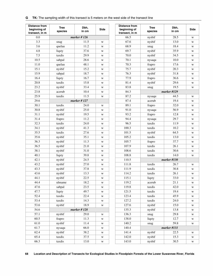
G TK: The sampling width of this transect is 5 meters on the west side of the transect line
Distance from beginning of transect, in m
Treespecies
Dbh,in cm
SideDistance from beginning of transect, in m
Treespecies
Dbh,in cm
Side
0.0 marker # 126 66.5 nysbif 28.5 w
3.3 snag 11.5 w 67.6 nysbif 13.0 w
3.6 quelau 11.2 w 68.9 snag 18.4 w
4.8 liqsty 37.6 w 69.7 nysbif 35.9 w
7.5 taxdis 29.9 w 70.0 nysbif 34.5 w
10.5 sabpal 28.6 w 70.1 nysaqu 10.0 w
11.0 quelau 48.1 w 70.3 frapro 17.6 w
15.1 nysbif 15.2 w 75.7 nysbif 20.3 w
15.9 sabpal 18.7 w 76.3 nysbif 31.8 w
16.4 liqsty 16.7 w 77.9 frapro 36.6 w
20.8 taxdis 15.8 w 81.4 nysbif 29.6 w
23.2 nysbif 33.4 w 83.8 snag 19.5 w
23.8 acerub 10.4 w 84.3 marker #129
25.9 taxdis 11.5 w 87.2 nysaqu 44.5 w
29.6 marker # 127 87.4 acerub 19.4 w
30.1 taxdis 24.0 w 89.1 frapro 32.0 w
30.8 nysbif 25.0 w 91.0 nysaqu 56.9 w
31.1 nysbif 19.5 w 93.2 frapro 12.8 w
31.4 frapro 11.2 w 94.4 nysaqu 29.7 w
32.3 taxdis 24.0 w 96.5 taxdis 11.9 w
34.1 nysbif 41.3 w 100.3 taxdis 10.2 w
35.5 taxdis 27.6 w 101.5 nysbif 64.5 w
35.6 nysbif 35.1 w 105.2 taxdis 13.0 w
36.3 nysbif 11.3 w 105.7 frapro 37.7 w
36.5 nysbif 21.0 w 107.9 taxdis 26.1 w
38.1 nysbif 31.0 w 108.6 taxdis 30.6 w
40.1 liqsty 39.8 w 108.8 taxdis 14.0 w
42.1 nysbif 24.5 w 110.5 marker #130
43.2 nysbif 27.0 w 111.8 taxdis 26.7 w
43.3 nysbif 37.8 w 111.9 taxdis 30.8 w
43.6 nysbif 13.3 w 114.2 taxdis 26.1 w
44.1 nysbif 22.5 w 115.1 liqsty 33.0 w
44.4 ulmame 18.2 w 119.2 acerub 21.1 w
47.6 sabpal 23.5 w 119.8 taxdis 42.0 w
47.7 liqsty 49.7 w 121.5 taxdis 19.4 w
52.4 taxdis 22.4 w 123.4 taxdis 45.9 w
53.4 taxdis 14.3 w 127.2 taxdis 24.0 w
53.6 nysbif 18.9 w 127.6 nysbif 15.0 w
54.6 marker # 128 135.3 nysbif 13.8 w
57.1 nysbif 29.0 w 136.3 snag 29.8 w
60.5 frapro 11.3 w 138.0 liqsty 12.7 w
61.0 nysbif 11.4 w 140.2 snag 59.8 w
61.7 nysaqu 66.0 w 140.4 marker #131
62.4 nysbif 38.2 w 141.4 nysbif 22.5 w
65.4 taxdis 37.5 w 142.0 nysbif 15.3 w
66.3 taxdis 13.0 w 143.0 nysbif 30.5 w
68 Location and Description of Transects for Ecological Studies in Floodplain Forests of the Lower Suwannee River, Florida

Appendix 1 69
145.7 taxdis 19.8 w 233.3 taxdis 15.6 w
148.4 nysbif 35.5 w 238.1 taxdis 24.8 w
153.6 ulmame 12.0 w 239.2 taxdis 22.9 w
156.3 carcar 15.4 w 241.4 marker #134
158.1 frapro 52.9 w 242.6 magvir 21.4 w
163.8 nysbif 22.5 w 243.2 taxdis 26.9 w
164.9 nysbif 10.4 w 243.7 taxdis 60.5 w
166.5 frapro23.8
w248.0 ulmame 13.0 w
5.2 248.6 frapro 16.9 w
166.8 frapro 51.8 w 255.5 ulmame 20.2 w
167.9 taxdis 22.0 w 256.0 nysbif 38.9 w
172.3 taxdis 18.3 w 256.8 nysbif 59.8 w
173.1 marker # 132 262.1 taxdis 16.0 w
173.3 taxdis 12.3 w 262.2 nysbif 19.7 w
175.5 frapro65.5
w262.3 nysbif 12.1 w
37.8 263.8 snag 15.4 w
176.7 nysbif 17.7 w 271.0 marker #135
176.9 nysbif 13.6 w 272.2 taxdis 30.0 w
181.5 frapro 23.9 w 272.3 snag 31.1 w
181.8 snag 30.5 w 276.1 snag 61.4 w
183.0 nysbif 61.0 w276.5 carcar
12.7w
183.2 quelau 19.0 w 8.7
185.4 nysbif 52.4 w 276.9 magvir 41.4 w
190.2 frapro 11.5 w 281.2 snag 44.0 w
190.6 taxdis 36.4 w 286.2 nysbif 17.0 w
192.8 taxdis 21.9 w 287.2 taxdis 10.6 w
193.9 taxdis 44.0 w 293.5 carcar 10.2 w
196.4 nysbif 11.5 w 295.4 quelau 21.7 w
197.3 nysbif 25.0 w 295.8 quelau 30.7 w
202.7 nysaqu 65.0 w 297.5 nysbif 59.9 w
202.9 nysbif 10.4 w 297.6 liqsty 22.5 w
205.9 marker # 133 300.1 snag 10.5 w
206.8 taxdis 14.6 w 302.0 nysbif 23.0 w
208.5 nysaqu 46.6 w 305.4 magvir 23.4 w
208.9 nysbif 17.0 w 305.8 marker # 136
211.6 snag 28.6 w 306.1 magvir 52.8 w
212.5 taxdis 53.6 w 306.4 nysbif 19.1 w
216.0 ulmame 13.1 w 313.3 frapro 23.2 w
216.3 ulmame 14.5 w 313.4 snag 34.8 w
219.9 frapro 12.0 w 318.4 magvir 55.0 w
221.5 nysbif 49.5 w 320.0 liqsty 12.2 w
221.8 snag 25.6 w 322.1 nysbif 19.4 w
224.2 taxdis 24.9 w 323.6 nysbif 11.0 w
227.3 frapro 20.6 w 323.9 nysbif 40.6 w
229.6 taxdis 46.9 w 325.4 nysbif 28.9 w
231.2 nysbif 19.5 w 327.8 magvir 10.2 w
G TK: The sampling width of this transect is 5 meters on the west side of the transect line
Distance from beginning of transect, in m
Treespecies
Dbh,in cm
SideDistance from beginning of transect, in m
Treespecies
Dbh,in cm
Side
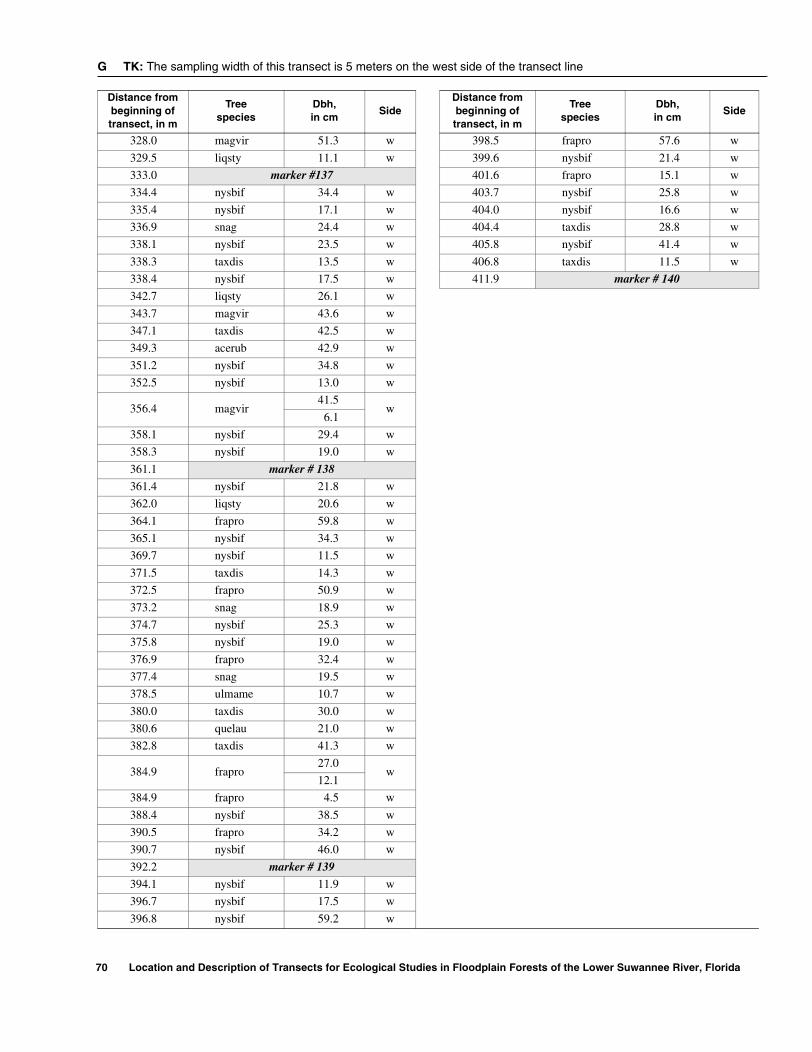
328.0 magvir 51.3 w 398.5 frapro 57.6 w
329.5 liqsty 11.1 w 399.6 nysbif 21.4 w
333.0 marker #137 401.6 frapro 15.1 w
334.4 nysbif 34.4 w 403.7 nysbif 25.8 w
335.4 nysbif 17.1 w 404.0 nysbif 16.6 w
336.9 snag 24.4 w 404.4 taxdis 28.8 w
338.1 nysbif 23.5 w 405.8 nysbif 41.4 w
338.3 taxdis 13.5 w 406.8 taxdis 11.5 w
338.4 nysbif 17.5 w 411.9 marker # 140
342.7 liqsty 26.1 w
343.7 magvir 43.6 w
347.1 taxdis 42.5 w
349.3 acerub 42.9 w
351.2 nysbif 34.8 w
352.5 nysbif 13.0 w
356.4 magvir41.5
w6.1
358.1 nysbif 29.4 w
358.3 nysbif 19.0 w
361.1 marker # 138
361.4 nysbif 21.8 w
362.0 liqsty 20.6 w
364.1 frapro 59.8 w
365.1 nysbif 34.3 w
369.7 nysbif 11.5 w
371.5 taxdis 14.3 w
372.5 frapro 50.9 w
373.2 snag 18.9 w
374.7 nysbif 25.3 w
375.8 nysbif 19.0 w
376.9 frapro 32.4 w
377.4 snag 19.5 w
378.5 ulmame 10.7 w
380.0 taxdis 30.0 w
380.6 quelau 21.0 w
382.8 taxdis 41.3 w
384.9 frapro27.0
w12.1
384.9 frapro 4.5 w
388.4 nysbif 38.5 w
390.5 frapro 34.2 w
390.7 nysbif 46.0 w
392.2 marker # 139
394.1 nysbif 11.9 w
396.7 nysbif 17.5 w
396.8 nysbif 59.2 w
G TK: The sampling width of this transect is 5 meters on the west side of the transect line
Distance from beginning of transect, in m
Treespecies
Dbh,in cm
SideDistance from beginning of transect, in m
Treespecies
Dbh,in cm
Side
70 Location and Description of Transects for Ecological Studies in Floodplain Forests of the Lower Suwannee River, Florida
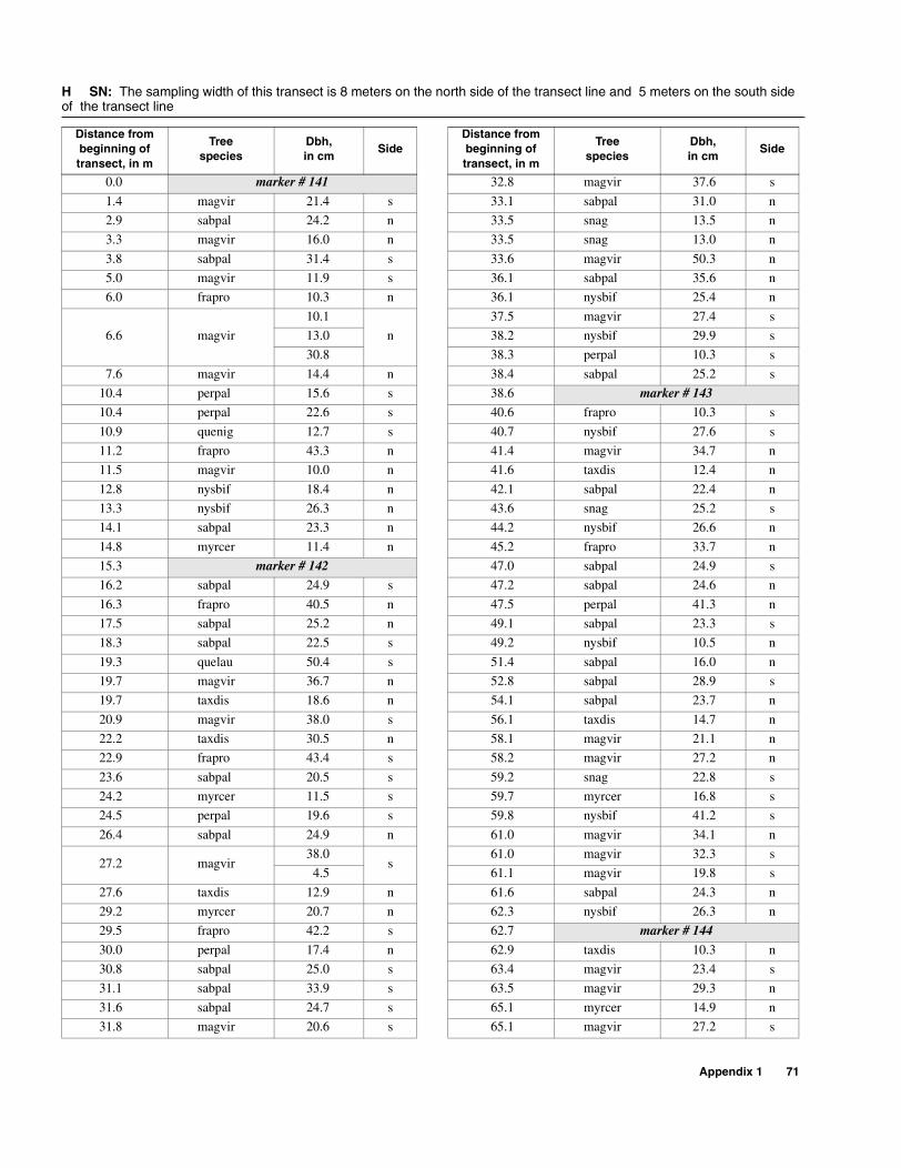
Appendix 1 71
H SN: The sampling width of this transect is 8 meters on the north side of the transect line and 5 meters on the south side of the transect line
Distance from beginning of transect, in m
Treespecies
Dbh,in cm
SideDistance from beginning of transect, in m
Treespecies
Dbh,in cm
Side
0.0 marker # 141 32.8 magvir 37.6 s
1.4 magvir 21.4 s 33.1 sabpal 31.0 n
2.9 sabpal 24.2 n 33.5 snag 13.5 n
3.3 magvir 16.0 n 33.5 snag 13.0 n
3.8 sabpal 31.4 s 33.6 magvir 50.3 n
5.0 magvir 11.9 s 36.1 sabpal 35.6 n
6.0 frapro 10.3 n 36.1 nysbif 25.4 n
6.6 magvir
10.1
n
37.5 magvir 27.4 s
13.0 38.2 nysbif 29.9 s
30.8 38.3 perpal 10.3 s
7.6 magvir 14.4 n 38.4 sabpal 25.2 s
10.4 perpal 15.6 s 38.6 marker # 143
10.4 perpal 22.6 s 40.6 frapro 10.3 s
10.9 quenig 12.7 s 40.7 nysbif 27.6 s
11.2 frapro 43.3 n 41.4 magvir 34.7 n
11.5 magvir 10.0 n 41.6 taxdis 12.4 n
12.8 nysbif 18.4 n 42.1 sabpal 22.4 n
13.3 nysbif 26.3 n 43.6 snag 25.2 s
14.1 sabpal 23.3 n 44.2 nysbif 26.6 n
14.8 myrcer 11.4 n 45.2 frapro 33.7 n
15.3 marker # 142 47.0 sabpal 24.9 s
16.2 sabpal 24.9 s 47.2 sabpal 24.6 n
16.3 frapro 40.5 n 47.5 perpal 41.3 n
17.5 sabpal 25.2 n 49.1 sabpal 23.3 s
18.3 sabpal 22.5 s 49.2 nysbif 10.5 n
19.3 quelau 50.4 s 51.4 sabpal 16.0 n
19.7 magvir 36.7 n 52.8 sabpal 28.9 s
19.7 taxdis 18.6 n 54.1 sabpal 23.7 n
20.9 magvir 38.0 s 56.1 taxdis 14.7 n
22.2 taxdis 30.5 n 58.1 magvir 21.1 n
22.9 frapro 43.4 s 58.2 magvir 27.2 n
23.6 sabpal 20.5 s 59.2 snag 22.8 s
24.2 myrcer 11.5 s 59.7 myrcer 16.8 s
24.5 perpal 19.6 s 59.8 nysbif 41.2 s
26.4 sabpal 24.9 n 61.0 magvir 34.1 n
27.2 magvir38.0
s61.0 magvir 32.3 s
4.5 61.1 magvir 19.8 s
27.6 taxdis 12.9 n 61.6 sabpal 24.3 n
29.2 myrcer 20.7 n 62.3 nysbif 26.3 n
29.5 frapro 42.2 s 62.7 marker # 144
30.0 perpal 17.4 n 62.9 taxdis 10.3 n
30.8 sabpal 25.0 s 63.4 magvir 23.4 s
31.1 sabpal 33.9 s 63.5 magvir 29.3 n
31.6 sabpal 24.7 s 65.1 myrcer 14.9 n
31.8 magvir 20.6 s 65.1 magvir 27.2 s

H SN: The sampling width of this transect is 8 meters on the north side of the transect line and 5 meters on the south side of the transect line
Distance from beginning of transect, in m
Treespecies
Dbh,in cm
Side
65.3 myrcer 10.4 s65.4 ulmame 16.3 n66.2 magvir 25.2 n66.4 nysbif 43.1 s66.8 frapro 25.6 n67.8 magvir 17.1 n68.1 magvir 30.2 n68.3 frapro 29.6 s69.2 nysbif 11.6 n70.6 perpal 14.5 n71.2 nysbif 28.6 n71.7 sabpal 22.1 n72.0 taxdis 20.2 n72.4 magvir 16.2 s73.4 taxdis 28.8 n74.3 frapro 29.5 n
74.3 frapro29.4
s15.9
76.0 perpal 12.5 s78.6 snag 40.0 s79.3 nysbif 27.5 n
79.3 myrcer22.2
n9.3
79.7 magvir 23.7 s80.0 magvir 32.3 n80.6 acerub 40.0 n82.3 sabpal 29.3 n82.5 taxdis 40.8 s82.6 sabpal 26.0 n83.5 taxdis 24.5 s84.2 myrcer 11.1 n85.3 snag 19.5 n86.5 magvir 20.6 s86.7 magvir 28.7 n88.3 sabpal 23.8 s88.3 marker # 145
88.4 myrcer11.0
s8.3
72 Location and Description of Transects for Ecological Studies in Floodplain Forests of the Lower Suwannee River, Florida
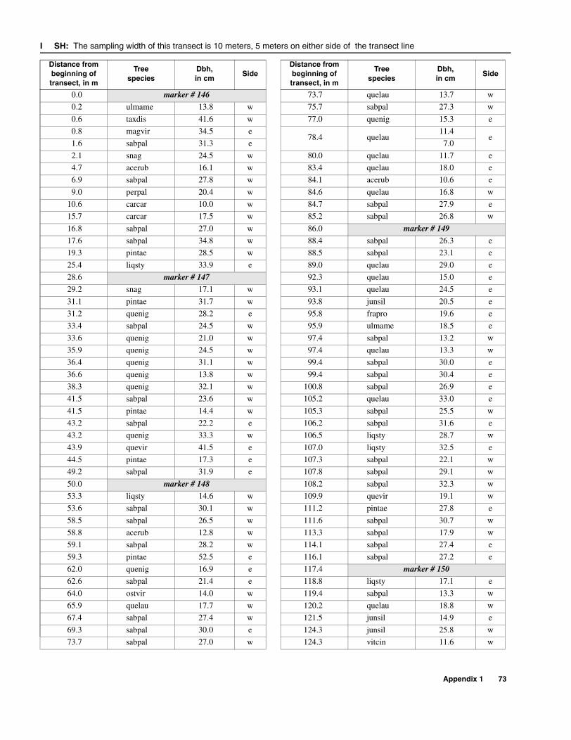
I SH: The sampling width of this transect is 10 meters, 5 meters on either side of the transect line
Distance from beginning of transect, in m
Treespecies
Dbh,in cm
SideDistance from beginning of transect, in m
Treespecies
Dbh,in cm
Side
0.0 marker # 146 73.7 quelau 13.7 w
0.2 ulmame 13.8 w 75.7 sabpal 27.3 w
0.6 taxdis 41.6 w 77.0 quenig 15.3 e
0.8 magvir 34.5 e78.4 quelau
11.4e
1.6 sabpal 31.3 e 7.0
2.1 snag 24.5 w 80.0 quelau 11.7 e
4.7 acerub 16.1 w 83.4 quelau 18.0 e
6.9 sabpal 27.8 w 84.1 acerub 10.6 e
9.0 perpal 20.4 w 84.6 quelau 16.8 w
10.6 carcar 10.0 w 84.7 sabpal 27.9 e
15.7 carcar 17.5 w 85.2 sabpal 26.8 w
16.8 sabpal 27.0 w 86.0 marker # 149
17.6 sabpal 34.8 w 88.4 sabpal 26.3 e
19.3 pintae 28.5 w 88.5 sabpal 23.1 e
25.4 liqsty 33.9 e 89.0 quelau 29.0 e
28.6 marker # 147 92.3 quelau 15.0 e
29.2 snag 17.1 w 93.1 quelau 24.5 e
31.1 pintae 31.7 w 93.8 junsil 20.5 e
31.2 quenig 28.2 e 95.8 frapro 19.6 e
33.4 sabpal 24.5 w 95.9 ulmame 18.5 e
33.6 quenig 21.0 w 97.4 sabpal 13.2 w
35.9 quenig 24.5 w 97.4 quelau 13.3 w
36.4 quenig 31.1 w 99.4 sabpal 30.0 e
36.6 quenig 13.8 w 99.4 sabpal 30.4 e
38.3 quenig 32.1 w 100.8 sabpal 26.9 e
41.5 sabpal 23.6 w 105.2 quelau 33.0 e
41.5 pintae 14.4 w 105.3 sabpal 25.5 w
43.2 sabpal 22.2 e 106.2 sabpal 31.6 e
43.2 quenig 33.3 w 106.5 liqsty 28.7 w
43.9 quevir 41.5 e 107.0 liqsty 32.5 e
44.5 pintae 17.3 e 107.3 sabpal 22.1 w
49.2 sabpal 31.9 e 107.8 sabpal 29.1 w
50.0 marker # 148 108.2 sabpal 32.3 w
53.3 liqsty 14.6 w 109.9 quevir 19.1 w
53.6 sabpal 30.1 w 111.2 pintae 27.8 e
58.5 sabpal 26.5 w 111.6 sabpal 30.7 w
58.8 acerub 12.8 w 113.3 sabpal 17.9 w
59.1 sabpal 28.2 w 114.1 sabpal 27.4 e
59.3 pintae 52.5 e 116.1 sabpal 27.2 e
62.0 quenig 16.9 e 117.4 marker # 150
62.6 sabpal 21.4 e 118.8 liqsty 17.1 e
64.0 ostvir 14.0 w 119.4 sabpal 13.3 w
65.9 quelau 17.7 w 120.2 quelau 18.8 w
67.4 sabpal 27.4 w 121.5 junsil 14.9 e
69.3 sabpal 30.0 e 124.3 junsil 25.8 w
73.7 sabpal 27.0 w 124.3 vitcin 11.6 w
Appendix 1 73

I SH: The sampling width of this transect is 10 meters, 5 meters on either side of the transect line (Continued)
Distance from beginning of transect, in m
Treespecies
Dbh,in cm
Side
124.8 quevir 26.0 w
125.7 quevir 54.9 w
128.0 sabpal 18.4 e
128.7 sabpal 29.9 w
130.9 sabpal 25.6 w
131.2 sabpal 26.2 e
132.8 sabpal 25.0 w
134.7 carcar 13.4 e
136.0 sabpal 29.9 e
136.5 sabpal 24.2 w
140.6 sabpal 28.1 e
141.7 sabpal 28.0 w
141.9 sabpal 26.3 e
144.0 sabpal 25.8 w
144.0 sabpal 23.9 e
147.2 sabpal 22.3 e
148.9 sabpal 30.5 e
151.0 marker # 151
155.0 quevir 62.2 e
74 Location and Description of Transects for Ecological Studies in Floodplain Forests of the Lower Suwannee River, Florida

J BC: The sampling width of this transect is 10 meters, 5 meters on either side of the transect line
Distance from beginning of transect, in m
Treespecies
Dbh,in cm
SideDistance from beginning of transect, in m
Treespecies
Dbh,in cm
Side
0.0 marker # 152 33.0 frapro 17.9 w
3.3 magvir 13.6 e 33.2 frapro 21.8 w
3.5 myrcer 17.8 e 33.2 sabpal 24.0 e
3.7 quevir 38.0 e
35.1 magvir
19.0
e4.2 sabpal 29.5 w 12.3
4.6 acerub 24.4 e 16.0
5.3 taxdis 16.5 w 35.6
5.7 frapro 34.1 w 36.8 frapro 47.5 w
8.0 nysbif 35.0 w 36.8 taxdis 12.4 e
9.0 acerub 21.4 w 38.7 sabpal 24.0 w
10.0 ulmame19.9
e40.5 frapro 26.5 e
21.1 41.6 frapro 26.4 e
10.5 sabpal 22.6 w 42.6 frapro 16.9 e
10.7 quelau 10.2 w 43.2 frapro 26.3 w
12.3 sabpal 28.2 e 43.4 frapro 26.2 e
12.7 frapro 14.0 w 43.5 frapro 24.5 w
12.8 taxdis 10.5 e 43.7 frapro 21.4 e
14.3 magvir 44.8 e 43.7 frapro 21.1 w
14.7 acerub 40.2 w 44.4 quelau 29.5 w
15.6 ulmame 23.4 w 44.8 marker # 154
16.6 magvir 12.3 w 45.8 frapro 24.4 w
18.5 ulmame 32.2 e 45.9 frapro 24.7 w
18.7 magvir 22.4 e 47.1 frapro 21.4 e
21.1 quelau 14.3 w 47.9 taxdis 11.2 e
21.2 quelau 12.4 e 48.1 frapro 21.7 w
22.4 frapro 17.2 e 48.5 frapro 16.0 e
22.5 frapro 15.4 w 48.7 frapro 27.4 w
22.7 quelau 14.1 e 49.0 frapro 38.6 e
22.8 nysbif 17.4 w 50.4 snag 11.0 w
23.8 marker # 153 52.7 sabpal 20.7 e
25.4 quelau 13.5 e53.2 frapro
13.4e
25.5 sabpal 18.4 e 17.7
26.3 sabpal 26.0 w 53.6 nysbif 27.5 e
27.3 nysbif 19.8 e 55.4 junsil 10.4 w
28.0 nysbif 20.0 w 55.6 magvir 33.9 w
29.1 frapro 43.8 e55.6 myrcer
11.9w
29.1 magvir
10.2
w
6.4
17.456.6 frapro
26.4e
8.9 27.8
32.0 56.7 taxdis 21.1 e
12.3 56.8 frapro 29.5 e
29.5 frapro 18.0 w 58.1 frapro 11.4 e
29.6 quelau 10.5 w 59.2 frapro 22.4 e
31.8 acerub 51.9 w 59.5 frapro 27.0 w
32.0 ulmame 23.4 w 59.9 frapro 33.5 w
32.8 frapro 33.1 e 62.5 frapro 19.0 w
Appendix 1 75

62.6 frapro 27.1 e 91.0 acerub 10.5 w
62.8 frapro 28.6 e 92.3 taxdis 42.3 e
63.6 frapro 16.9 e 93.0 taxdis 42.2 w
65.1 junsil 13.1 w 97.0 frapro 20.1 e
65.4 sabpal 23.0 w 97.6 frapro 30.2 e
65.5 taxdis 10.0 w100.0 frapro
10.3e
66.0 frapro16.7
e10.0
8.4 101.3 frapro 26.8 e
70.2 nysbif 29.7 w 101.7 frapro 17.5 e
70.6 frapro 12.7 e 101.7 frapro 40.6 w
70.7 frapro 22.0 w 101.9 frapro 31.1 e
72.2 frapro 28.5 w 102.0 snag 11.7 e
72.4 snag 40.4 e 102.9 quelau 12.7 w
72.6 frapro 29.0 e 103.6 frapro 25.9 e
73.0 marker # 155 103.7 frapro 27.2 w
73.4 frapro 22.7 w 103.8 marker # 156
74.3 frapro 13.3 w 104.3 snag 22.0 e
75.0 frapro22.0
e104.9 nysbif 36.9 e
19.6 105.0 frapro 14.4 w
75.5 frapro 31.9 w 105.5 frapro 25.3 e
75.6 frapro 22.0 w 106.3 quelau 10.8 e
76.4 frapro 32.5 w 107.3 frapro 17.3 e
77.7 frapro
17.3
e
107.3 frapro 18.0 e
13.5 111.0 acerub 14.2 w
10.3 113.8 nysbif 35.0 e
79.9 nysbif 30.0 w 114.2 frapro 25.4 e
80.1 frapro 17.4 w 114.6 taxdis 29.8 e
80.5 taxdis 27.7 e 115.0 frapro 20.6 w
80.9 magvir 25.7 w 115.9 junsil 17.7 w
81.1 frapro 17.7 e 116.3 frapro 21.5 e
81.1 frapro 15.0 e 116.3 quelau 11.8 e
81.2 frapro 14.2 e 118.7 sabpal 27.5 e
82.1 snag 25.4 e 119.3 taxdis 21.5 w
82.7 frapro 22.2 w 119.4 frapro 20.7 w
82.8 taxdis 32.1 e 120.1 frapro 24.5 w
84.9 frapro 32.7 e 120.3 frapro 17.9 e
84.9 frapro 24.8 e 124.1 taxdis 121.0 w
85.0 frapro 22.2 w 124.9 acerub 52.0 e
85.5 taxdis 27.2 e 125.9 sabpal 25.6 e
85.6 frapro 20.0 w 127.2 sabpal 28.3 w
86.4 frapro 37.3 w 127.6 sabpal 26.8 w
87.0 frapro 20.0 e 130.3 frapro 33.0 w
89.2 frapro 26.9 e 130.9 frapro 22.9 w
89.8 frapro 16.5 e 131.2 taxdis 15.2 e
90.3 frapro 29.4 e 131.8 taxdis 22.7 e
90.7 frapro 27.4 e 132.9 frapro 20.2 e
J BC: The sampling width of this transect is 10 meters, 5 meters on either side of the transect line (Continued)
Distance from beginning of transect, in m
Treespecies
Dbh,in cm
SideDistance from beginning of transect, in m
Treespecies
Dbh,in cm
Side
76 Location and Description of Transects for Ecological Studies in Floodplain Forests of the Lower Suwannee River, Florida

134.0 sabpal 25.2 e 179.4 nysbif 27.8 w
134.9 nysbif 13.2 w 181.3 magvir 15.1 e
135.3 ulmame 36.5 e 182.0 taxdis 31.1 e
135.6 sabpal 19.9 w182.6 frapro
21.4w
136.2 acerub 33.8 w 12.4
137.1 sabpal 26.1 e183.8 frapro
13.2e
139.0 frapro 42.4 w 11.1
140.1 sabpal 24.8 e 184.0 frapro 14.9 e
141.5 acerub 70.0 e 184.4 frapro 24.9 w
141.5 taxdis 12.4 w186.3 nysbif
30.6w
143.9 frapro 31.7 e 24.9
144.2 taxdis 15.1 w 186.8 carcar 10.0 w
145.9 frapro 10.9 e 188.0 frapro 13.4 e
146.3 acerub 42.8 w 188.1 taxdis 17.3 e
146.6 frapro 11.1 e 189.1 marker # 158
146.9 myrcer 12.2 e 189.8 frapro 24.8 e
147.3 marker # 157 191.0 frapro 44.1 e
150.9 pintae 20.6 e 191.0 frapro 33.5 w
151.3 ulmame 10.9 e 193.2 taxdis 47.5 e
151.9 junsil 16.1 e 195.9 junsil 10.9 e
153.1 sabpal 27.9 e 196.2 nysbif 10.3 e
154.0 frapro 67.0 e 196.3 sabpal 25.8 w
154.5 taxdis 11.2 w 197.3 sabpal 18.3 e
155.8 ulmame 29.8 w 200.2 acerub 33.2 w
157.7 frapro 21.0 e 200.8 ulmame 34.7 w
159.0 taxdis 28.5 w 201.2 magvir 11.5 e
159.8 taxdis 46.9 w 202.9 taxdis 45.2 e
160.0 quelau 10.2 e 203.7 frapro 10.9 w
160.2 taxdis 26.6 w 203.8 frapro 38.7 e
161.7 frapro 23.4 w 204.3 frapro 14.2 w
163.9 ulmame 40.2 e 206.9 frapro 21.9 w
164.2 taxdis 15.8 w 208.0 taxdis 13.6 e
164.5 frapro 24.0 e 208.1 ulmame 25.2 e
164.5 taxdis 15.0 w 208.4 nysbif 36.7 e
164.7 acerub 45.0 w 210.6 nysbif 20.7 w
166.3 snag 16.4 w 210.8 frapro 22.0 w
167.1 taxdis 33.3 w 211.2 nysbif 26.7 e
167.9 frapro 31.8 e 212.2 snag 19.4 e
168.8 sabpal 25.8 w 213.4 nysbif 24.5 w
171.0 frapro 28.8 e 213.5 snag 14.7 w
171.0 taxdis 27.8 w 214.5 frapro 24.0 e
172.2 frapro 42.9 w 215.6 marker # 159
175.0 taxdis 38.7 w
175.6 magvir 43.4 e
178.3 sabpal 24.3 e
178.9 frapro 22.1 e
J BC: The sampling width of this transect is 10 meters, 5 meters on either side of the transect line (Continued)
Distance from beginning of transect, in m
Treespecies
Dbh,in cm
SideDistance from beginning of transect, in m
Treespecies
Dbh,in cm
Side
Appendix 1 77
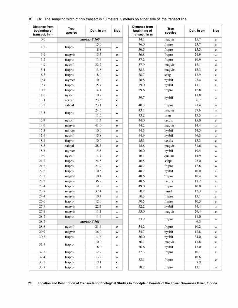
K LK: The sampling width of this transect is 10 meters, 5 meters on either side of the transect line
Distance from beginning of transect, in m
Treespecies
Dbh, in cm SideDistance from beginning of transect, in m
Treespecies
Dbh, in cm Side
0.0 marker # 160 34.1 magvir 15.7 e
1.8 frapro15.0
w36.0 frapro 23.7 e
8.8 36.5 frapro 15.3 e
1.9 magvir 15.5 e 36.8 frapro 24.9 w
3.2 frapro 13.4 w 37.2 frapro 19.9 w
4.9 nysbif 22.2 w 37.9 magvir 12.1 e
5.1 frapro 13.8 w 38.3 magvir 13.3 e
6.3 frapro 18.0 w 38.7 snag 13.9 e
9.4 myrcer 10.0 e 38.8 nysbif 25.4 w
9.7 frapro 15.7 w 39.0 nysbif 11.1 e
10.3 frapro 14.4 w 39.6 frapro 12.8 e
11.0 nysbif 10.7 w39.7 nysbif
11.8w
13.1 acerub 23.5 e 6.7
13.2 sabpal 23.1 e 40.3 frapro 21.4 w
13.5 frapro24.5
w43.1 magvir 27.6 w
11.5 43.2 snag 13.5 w
13.7 nysbif 11.4 e 44.0 taxdis 15.0 e
14.6 magvir 41.0 e 44.2 magvir 14.4 w
15.3 myrcer 10.0 e 44.5 nysbif 24.5 e
15.6 nysbif 15.8 w 44.9 nysbif 46.3 w
18.4 frapro 10.0 w 45.3 taxdis 13.3 e
18.5 sabpal 28.3 e 45.8 magvir 31.6 w
18.8 myrcer 15.5 w 46.0 nysbif 19.5 w
19.0 nysbif 14.7 e 46.1 quelau 14.9 w
21.2 frapro 24.5 e 46.5 sabpal 23.0 w
21.6 frapro 21.9 w 48.2 frapro 12.6 w
22.2 frapro 10.5 w 48.2 nysbif 10.0 e
22.3 magvir 10.4 e 48.6 frapro 10.4 w
23.2 magvir 36.9 e 48.6 taxdis 11.2 e
23.4 frapro 19.0 w 49.0 frapro 10.0 e
23.7 magvir 37.4 w 50.2 junsil 12.3 w
24.4 magvir 10.4 w 50.3 frapro 13.1 e
26.0 frapro 12.0 e 50.5 frapro 10.3 e
27.9 magvir 22.7 e 52.2 nysbif 34.4 w
27.9 magvir 11.1 w 53.0 magvir 29.4 e
28.2 frapro 11.4 w53.9 frapro
11.0w
28.7 marker # 161 6.3
28.8 nysbif 21.4 e 54.2 frapro 10.2 w
29.9 magvir 36.0 w 54.7 nysbif 12.8 e
30.8 frapro 11.6 e 56.0 nysbif 34.0 w
31.4 frapro10.0
w56.1 magvir 17.8 e
6.0 56.6 nysbif 13.0 e
32.3 frapro 12.9 w 57.3 frapro 10.1 e
32.4 frapro 13.2 w58.1 frapro
10.6e
33.2 frapro 19.1 e 7.9
33.7 frapro 11.4 e 58.2 frapro 13.1 w
78 Location and Description of Transects for Ecological Studies in Floodplain Forests of the Lower Suwannee River, Florida
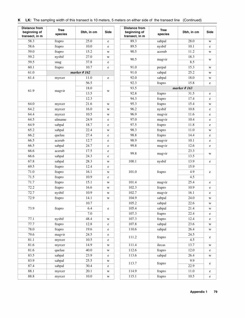
58.3 frapro 25.0 e 89.3 sabpal 28.0 w
58.6 frapro 10.0 e 89.5 nysbif 10.1 e
59.0 frapro 15.2 w 90.5 acerub 11.2 w
59.2 nysbif 27.0 w90.5 magvir
18.3w
59.5 snag 37.8 e 8.5
60.1 frapro 10.7 e 91.0 perpal 15.3 w
61.0 marker # 162 91.0 sabpal 25.2 w
61.4 myrcer 11.0 e 92.0 sabpal 18.0 w
61.9 magvir
56.5
w
92.3 frapro 15.8 e
18.0 93.5 marker # 163
13.5 92.8 frapro 31.5 e
12.3 94.3 frapro 17.4 e
64.0 myrcer 21.6 w 95.3 frapro 15.4 w
64.2 myrcer 16.0 w 96.2 nysbif 10.8 e
64.4 myrcer 10.5 w 96.9 magvir 11.6 e
64.5 ulmame 24.9 e 97.0 magvir 10.4 e
64.9 sabpal 18.7 e 97.5 frapro 11.8 e
65.2 sabpal 22.4 w 98.3 frapro 11.0 w
66.2 quelau 27.4 e 98.8 frapro 14.4 e
66.5 acerub 12.7 e 98.9 magvir 10.1 e
66.5 sabpal 24.7 e 99.8 magvir 12.6 e
66.6 acerub 17.5 e99.8 magvir
23.3w
66.6 sabpal 24.3 e 13.5
67.8 sabpal 28.3 w 100.1 nysbif 13.9 e
69.5 frapro 12.4 e
101.0 frapro
15.9
e71.0 frapro 16.1 w 4.9
71.5 frapro 10.9 e 4.5
71.7 frapro 15.1 w 101.4 magvir 25.4 e
72.2 frapro 16.6 w 102.3 frapro 10.9 e
72.7 nysbif 10.9 w 102.7 magvir 16.1 e
72.9 frapro 14.1 w 104.9 sabpal 24.0 w
73.9 frapro
10.7
e
105.2 sabpal 22.6 w
6.4 105.4 sabpal 21.4 w
7.0 107.3 frapro 22.4 e
77.1 nysbif 48.4 w 107.3 frapro 12.4 e
77.7 frapro 12.8 e 107.8 sabpal 23.6 w
78.0 frapro 19.6 e 110.6 sabpal 26.4 w
79.6 magvir 24.5 e111.2 frapro
24.5e
81.1 myrcer 10.5 e 4.5
81.6 myrcer 14.9 w 111.4 ilecas 13.7 w
81.6 quelau 40.0 w 112.6 frapro 12.0 e
83.5 sabpal 23.9 e 113.6 sabpal 26.4 w
83.9 sabpal 25.5 w113.7 frapro
9.9e
87.4 sabpal 30.4 e 22.9
88.1 myrcer 20.1 w 114.9 frapro 11.0 e
88.8 myrcer 10.0 w 115.1 frapro 10.5 e
K LK: The sampling width of this transect is 10 meters, 5 meters on either side of the transect line (Continued)
Distance from beginning of transect, in m
Treespecies
Dbh, in cm SideDistance from beginning of transect, in m
Treespecies
Dbh, in cm Side
Appendix 1 79

K LK: The sampling width of this transect is 10 meters, 5 meters on either side of the transect line (Continued)
Distance from beginning of transect, in m
Treespecies
Dbh, in cm Side
115.9 frapro 15.3 e
116.5 frapro 10.7 w
116.6 frapro 9.2 e
117.4 marker # 164
118.6 taxdis 12.2 e
119.3 frapro 11.4 w
119.7 nysbif 10.4 e
120.6 nysbif34.0
e9.0
121.8 nysbif 11.7 e
122.0 nysbif 14.6 w
122.3 frapro 10.7 e
122.4 taxdis 44.7 e
123.4 nysbif 10.3 w
124.8 frapro 10.2 e
126.3 nysbif 13.5 e
130.7 taxdis 21.2 w
131.1 taxdis 14.9 w
133.3 taxdis 19.4 w
133.7 taxdis 24.3 w
133.8 taxdis 23.2 w
134.7 taxdis 34.6 e
135.5 frapro 15.4 w
139.8 taxdis 37.3 w
142.1 taxdis 36.0 w
143.2 taxdis 10.9 e
145.5 marker # 165
80 Location and Description of Transects for Ecological Studies in Floodplain Forests of the Lower Suwannee River, Florida
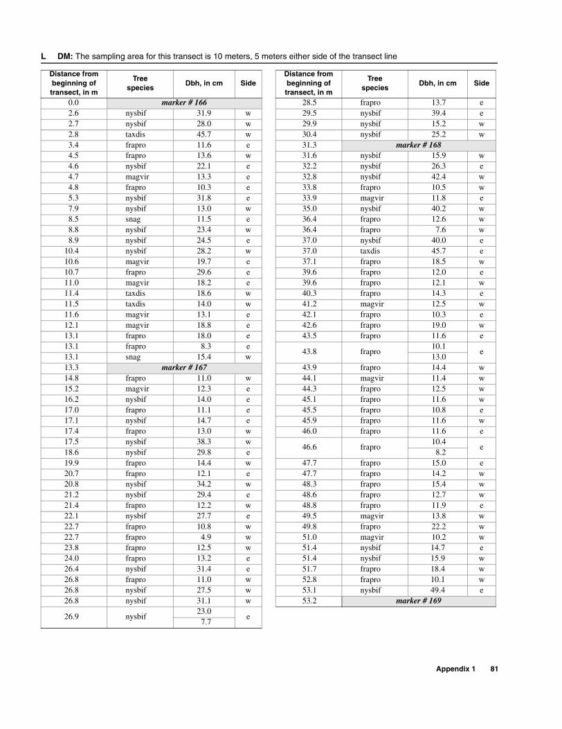
L DM: The sampling area for this transect is 10 meters, 5 meters either side of the transect line
Distance from beginning of transect, in m
Treespecies
Dbh, in cm SideDistance from beginning of transect, in m
Treespecies
Dbh, in cm Side
0.0 marker # 166 28.5 frapro 13.7 e2.6 nysbif 31.9 w 29.5 nysbif 39.4 e2.7 nysbif 28.0 w 29.9 nysbif 15.2 w2.8 taxdis 45.7 w 30.4 nysbif 25.2 w3.4 frapro 11.6 e 31.3 marker # 1684.5 frapro 13.6 w 31.6 nysbif 15.9 w4.6 nysbif 22.1 e 32.2 nysbif 26.3 e4.7 magvir 13.3 e 32.8 nysbif 42.4 w4.8 frapro 10.3 e 33.8 frapro 10.5 w5.3 nysbif 31.8 e 33.9 magvir 11.8 e7.9 nysbif 13.0 w 35.0 nysbif 40.2 w8.5 snag 11.5 e 36.4 frapro 12.6 w8.8 nysbif 23.4 w 36.4 frapro 7.6 w8.9 nysbif 24.5 e 37.0 nysbif 40.0 e
10.4 nysbif 28.2 w 37.0 taxdis 45.7 e10.6 magvir 19.7 e 37.1 frapro 18.5 w10.7 frapro 29.6 e 39.6 frapro 12.0 e11.0 magvir 18.2 e 39.6 frapro 12.1 w11.4 taxdis 18.6 w 40.3 frapro 14.3 e11.5 taxdis 14.0 w 41.2 magvir 12.5 w11.6 magvir 13.1 e 42.1 frapro 10.3 e12.1 magvir 18.8 e 42.6 frapro 19.0 w13.1 frapro 18.0 e 43.5 frapro 11.6 e13.1 frapro 8.3 e
43.8 frapro10.1
e13.1 snag 15.4 w 13.013.3 marker # 167 43.9 frapro 14.4 w14.8 frapro 11.0 w 44.1 magvir 11.4 w15.2 magvir 12.3 e 44.3 frapro 12.5 w16.2 nysbif 14.0 e 45.1 frapro 11.6 w17.0 frapro 11.1 e 45.5 frapro 10.8 e17.1 nysbif 14.7 e 45.9 frapro 11.6 w17.4 frapro 13.0 w 46.0 frapro 11.6 e17.5 nysbif 38.3 w
46.6 frapro10.4
e18.6 nysbif 29.8 e 8.219.9 frapro 14.4 w 47.7 frapro 15.0 e20.7 frapro 12.1 e 47.7 frapro 14.2 w20.8 nysbif 34.2 w 48.3 frapro 15.4 w21.2 nysbif 29.4 e 48.6 frapro 12.7 w21.4 frapro 12.2 w 48.8 frapro 11.9 e22.1 nysbif 27.7 e 49.5 magvir 13.8 w22.7 frapro 10.8 w 49.8 frapro 22.2 w22.7 frapro 4.9 w 51.0 magvir 10.2 w23.8 frapro 12.5 w 51.4 nysbif 14.7 e24.0 frapro 13.2 e 51.4 nysbif 15.9 w26.4 nysbif 31.4 e 51.7 frapro 18.4 w26.8 frapro 11.0 w 52.8 frapro 10.1 w26.8 nysbif 27.5 w 53.1 nysbif 49.4 e26.8 nysbif 31.1 w 53.2 marker # 169
26.9 nysbif23.0
e7.7
Appendix 1 81

Appendix 2. Conversion tables for determining the permanent marker numbers of all previous stake numbers recorded in original U.S. Geological Survey field notes
CONFLUENCE LOG LANDING FALKENBURRY
Stake numberin originalfield notes
Permanentmarkernumber
Stake number in original field notes
Permanentmarkernumber
Stake numberin originalfield notes
Permanent markernumber
West segment 1 22 East segment
1 1 2 23 1 52
2 2 3 24 2 53
3 3 4 25 3 54
4 4 5 26 4 55
5 5 6 27 5 56
6 6 7 28 6 57
7 7 8 29 7 58
East segment 9 30 West segment
1 8 10 31 8 59
2 9 11 32 7 60
3 10 12 33 6 61
4 11 13 34 5 62
5 12 14 35 4 63
6 13 15 36 3 64
7 14 16 37 2 65
8 15 17 38 1 66
9 16 18a 39
10 17 18b 40
11 18 19 41
12 19 20 42
13 20 21 43
14 21 22 44
23 45
24 46
25 47
26 48
27 49
28 50
29 51
82 Location and Description of Transects for Ecological Studies in Floodplain Forests of the Lower Suwannee River, Florida
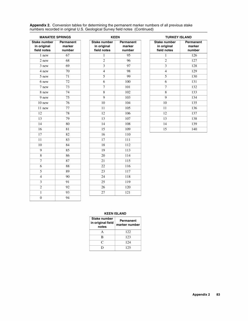
Appendix 2. Conversion tables for determining the permanent marker numbers of all previous stake numbers recorded in original U.S. Geological Survey field notes (Continued)
MANATEE SPRINGS KEEN TURKEY ISLAND
Stake number in originalfield notes
Permanent markernumber
Stake number in originalfield notes
Permanent markernumber
Stake numberin originalfield notes
Permanent markernumber
1 new 67 1 95 1 126
2 new 68 2 96 2 127
3 new 69 3 97 3 128
4 new 70 4 98 4 129
5 new 71 5 99 5 130
6 new 72 6 100 6 131
7 new 73 7 101 7 132
8 new 74 8 102 8 133
9 new 75 9 103 9 134
10 new 76 10 104 10 135
11 new 77 11 105 11 136
12 78 12 106 12 137
13 79 13 107 13 138
14 80 14 108 14 139
16 81 15 109 15 140
17 82 16 110
11 83 17 111
10 84 18 112
9 85 19 113
8 86 20 114
7 87 21 115
6 88 22 116
5 89 23 117
4 90 24 118
3 91 25 119
2 92 26 120
1 93 27 121
0 94
KEEN ISLAND
Stake number in original field
notes
Permanent marker number
A 122
B 123
C 124
D 125
Appendix 2 83

Appendix 2. Conversion tables for determining the permanent marker numbers of all previous stake numbers recorded in original U.S. Geological Survey field notes (Continued)
SANDFLY NORTH SANDFLY HAMMOCK BARNETT CREEK
Stake number in original field notes
Permanent marker number
Stake num-ber in original
field notes
Permanent marker number
Stake number in original field notes
Permanent marker number
1 141 1 146 1 152
2 142 2 147 2 153
3 143 3 148 3 154
4 144 4 149 4 155
5 145 5 150 5 156
6 151 6 157
7 158
8 159LOCK CREEK DEMORY CREEK
Stake number in original field notes
Permanent marker number
Stake num-ber in original
field notes
Permanent marker number
1 160 1 166
2 161 2 167
3 162 3 168
4 163 4 169
5 164
6 165
84 Location and Description of Transects for Ecological Studies in Floodplain Forests of the Lower Suwannee River, Florida