Local refinement of TAN 8 Strategic Search Areas B and C
113
Powys County Council Local refinement of TAN 8 Strategic Search Areas B and C Review Exercise
Transcript of Local refinement of TAN 8 Strategic Search Areas B and C

Powys County Council
Local refinement of TAN 8 Strategic Search Areas B and C
Review Exercise

Powys County Council
Local refinement of TAN 8 Strategic Search Areas B and C
Review Exercise April 2008
This report takes into account the
particular instructions and requirements of our client. It is not intended for and should not be relied upon by any third party and no responsibility is undertaken to any third party
Ove Arup & Partners Ltd Central Square, Forth Street, Newcastle upon Tyne NE1 3PL Tel +44 (0)191 261 6080 Fax +44 (0)191 261 7879 www.arup.com Job number 123944

\\WACNAS04\JOBS\123000\123944-00\4 INTERNAL PROJECT DATA\4-50 REPORTS\FINAL REPORT_11.04.08.DOC
Ove Arup & Partners LtdIssue 11 April 2008
Document VerificationPage 1 of 1
Job number Job title Local refinement of TAN 8 Strategic Search Areas B and C
123944
File reference Document title Review Exercise
Document ref
Revision Date Filename Draft Report 01.doc
Description First draft
Prepared by Checked by Approved by
Name Cathy Edy Simon White/Simon Power
Simon Power
Draft 1 08/01/08
Signature
Filename Draft Report 02_CE.doc
Description Updated following site review and internal review
Prepared by Checked by Approved by
Name Cathy Edy Simon White/Simon Power
Simon Power
Draft 2 12/02/08
Signature
Filename Draft Final Report 03_CE_07.03.08 corrected boundaries.doc
Description Updated with correct draft 2006 IDCG boundaries
Prepared by Checked by Approved by
Name Cathy Edy Simon White/Simon Power
Simon Power
Draft 3 07/03/08
Signature
Filename Final Report_11.04.08.doc
Description IDCG consultation responses moved to a separate document
Prepared by Checked by Approved by
Name Cathy Edy Simon White/Simon Power
Simon Power
Issue 11/04/08
Signature
Issue Document Verification with Document

Powys County Council Local refinement of TAN 8 Strategic Search Areas B and CReview Exercise
\\WACNAS04\JOBS\123000\123944-00\4 INTERNAL PROJECT DATA\4-50 REPORTS\FINAL REPORT_11.04.08.DOC
Ove Arup & Partners LtdIssue 11 April 2008
Contents
Page 1 Introduction 1
1.1 Overview 1 1.2 Brief 1 1.3 Report structure 2
2 Methodology and analysis 3 2.1 Methodology – The Review Process 3 2.2 Study Area/Units of analysis 3 2.3 Landscape sensitivity analysis 9 2.4 Visual Data 14 2.5 Deriving a least impact/refined SSA boundary 24 2.6 Comparison with 2006 draft IDCG refined boundaries 33
3 Conclusions and recommendations 36 3.1 Study findings/Conclusions 36
Appendices Appendix A Landscape Sensitivity Summary Sheets

Powys County Council Local refinement of TAN 8 Strategic Search Areas B and CReview Exercise
\\WACNAS04\JOBS\123000\123944-00\4 INTERNAL PROJECT DATA\4-50 REPORTS\FINAL REPORT_11.04.08.DOC
Page 1 Ove Arup & Partners LtdIssue 11 April 2008
1 Introduction 1.1 Overview
Technical Advice Note 8: Planning for Renewable Energy ( TAN 8 ) was published in June 2005. It contains details of seven Strategic Search Areas ( SSAs ) for onshore windfarms which are located throughout Wales. Two of these – SSAs B ( Carno North ) and C – Newtown South ), are located in Mid Wales in Powys County Council ( PCC ). TAN 8 contains, as an annex, a methodology for local planning authorities to refine their SSAs, taking into account aspect of the local environment, principally landscape/ visual issues and cumulative impact issues.
PCC appointed White Consultants with Arup and sub consultants in the summer of 2005, shortly after the finalisation of TAN 8, to begin work on a refinement exercise of SSAs B and C. The outcomes led to the preparation of a report on the local refinement process. This was published in January 20061. The planning response to the study was prepared in early Spring 2006 and was issued for consultation ( between 13th Feb and 27th March 06 ) in the form of Draft Interim Development Control Guidance2 ( IDCG ), pending formal consideration of revised policies as part of the Local Development Plan process. The Draft IDCG contained refined boundaries3 judged to be capable of meeting the TAN 8 indicative capacity for SSAs B and C, namely 290MW and 70MW of installed renewable energy capacity respectively.
This review of the refinement boundaries for SSA B and C was commissioned by PCC following feedback on the nature and extent of the refinement boundaries following the publication of the Draft IDCG and the Inspector’s decision letter for the Wern Ddu appeal4.
1.2 Brief
The brief for this study, agreed in dialogue with PCC, was to undertake a new local refinement of the boundary of the nationally published Strategic Search Areas (SSAs) for SSA B (Carno North) and SSA C (Newtown South). The new local refinement exercise was to follow the principles as set out below:
• It was to comply as far as possible with the guidance contained within TAN 8 Annex D
• It was not to serve to ‘cap’ development levels at the TAN 8 indicative capacities (in MW) for each SSA where the data indicated that greater levels of development might be possible i.e. the outcomes were to be driven by the landscape capacity of the area, within the context of an overall national policy objective to allow landscape change.
This new study has been undertaken by an Arup team with ad-hoc support from White Consultants and the University of Northumbria.
1 TAN 8 Annex D study of TAN 8 Strategic Search Areas B ( Carno North ) and C ( Newtown South )–– Arup in conjunction with White Consultants and the Centre for Environmental and Spatial Analysis, Jan 2006. 2 http://www.powys.gov.uk/uploads/media/WindEnergySPG_en_01.pdf 3 The Carno and Llanbadarn Wind Farm zones 4 Denbighshire County Council - Appeal decision APP/R6830/A/05/1185359 15 June 2007.

Powys County Council Local refinement of TAN 8 Strategic Search Areas B and CReview Exercise
\\WACNAS04\JOBS\123000\123944-00\4 INTERNAL PROJECT DATA\4-50 REPORTS\FINAL REPORT_11.04.08.DOC
Page 2 Ove Arup & Partners LtdIssue 11 April 2008
1.3 Report structure
This review report uses the same basic structure as the original refinement study and as such is organised under the following main headings of:
• Introduction/Brief
• Methodology and analysis including:
− Technical and Environmental Constraints Review and
− Landscape and Visual Analysis
• Conclusions and Recommendations
To understand the full context of this review, this report should be read in conjunction with the original refinement study report.

Powys County Council Local refinement of TAN 8 Strategic Search Areas B and CReview Exercise
\\WACNAS04\JOBS\123000\123944-00\4 INTERNAL PROJECT DATA\4-50 REPORTS\FINAL REPORT_11.04.08.DOC
Page 3 Ove Arup & Partners LtdIssue 11 April 2008
2 Methodology and analysis 2.1 Methodology – The Review Process
The review process undertaken can be summarised in the following flow diagram and is explained below in the sections which follows.
2.2 Study Area/Units of analysis
A technical and environmental constraints review of the SSA(s) and a 5km buffered margin (based on that used for the original refinement exercise) was undertaken to focus the scope of the area to be subject to the landscape and visual analysis. It comprised a standard constraint sieving exercise using a Geographic Information System (GIS), similar to that undertaken by all wind farm developers when selecting sites. This identified the “unconstrained5” land with respect to range of parameters which can then be tested for its suitability in landscape and visual terms. The technical and environmental constraints remain as described in the original refinement study report. The unconstrained land within the TAN 8 boundaries for SSA B and C is shown in Figures 1a and 1b.
5 “Unconstrained” in this context refers to the absence of a set of pre-defined technical and environmental constraints that prohibit development in absolute terms. It does not relate to the landscape and visual characteristics of an area or suggest that there are not other constraints that either singularly or in combination may affect the ability to develop wind turbines.
2.3 Re-evaluation of landscape sensitivity for new zones in the field and completion of working landscape sensitivity and capacity sheets
2.5 Undertake review of sensitive landscape features and settings Reassess refined boundary
2.2 Undertake review of land unconstrained with respect to wind farms. Preparation of New Zones based on re-evaluation in response to third party representations.
2.4 Determine overall visual sensitivity of zones

Powys County Council Local refinement of TAN 8 Strategic Search Areas B and CReview Exercise
\\WACNAS04\JOBS\123000\123944-00\4 INTERNAL PROJECT DATA\4-50 REPORTS\FINAL REPORT_11.04.08.DOC
Page 4 Ove Arup & Partners LtdIssue 11 April 2008
Figure 1a SSA B Technical and Environmental Constraints
Figure 1b SSA C Technical and Environmental Constraints

Powys County Council Local refinement of TAN 8 Strategic Search Areas B and CReview Exercise
\\WACNAS04\JOBS\123000\123944-00\4 INTERNAL PROJECT DATA\4-50 REPORTS\FINAL REPORT_11.04.08.DOC
Page 5 Ove Arup & Partners LtdIssue 11 April 2008
In the original refinement exercise areas of highest absolute constraints were excluded from the zone creation process. The zones were derived from the LANDMAP visual and sensory aspect layer data for Powys CC and were verified in the field; see the Arup 2006 Refinement Report.
The original refinement exercise used wind speed of <7m/s-1 as an absolute constraint in line with the constraints used for the derivation of the national TAN 8 boundaries. As wind turbine technology has progressed turbine heights have increased to provide greater energy yield at lower wind speeds. Figures 2a and 2b illustrate the increase in unconstrained land, in terms of absolute constraints, if lower wind speeds are used to define the constraints within the study area reflecting the increasing practice of wind developers expanding their search areas to include areas of lower wind speed.

Powys County Council Local refinement of TAN 8 Strategic Search Areas B and CReview Exercise
\\WACNAS04\JOBS\123000\123944-00\4 INTERNAL PROJECT DATA\4-50 REPORTS\FINAL REPORT_11.04.08.DOC
Page 6 Ove Arup & Partners LtdIssue 11 April 2008
Figure 2a SSA B Technical and Environmental Constraints with Varied Wind Speed
Figure 2b SSA C Technical and Environmental Constraints with Varied Wind Speed

Powys County Council Local refinement of TAN 8 Strategic Search Areas B and CReview Exercise
\\WACNAS04\JOBS\123000\123944-00\4 INTERNAL PROJECT DATA\4-50 REPORTS\FINAL REPORT_11.04.08.DOC
Page 7 Ove Arup & Partners LtdIssue 11 April 2008
There is a generally limited increase in unconstrained land in SSA B when lower wind speeds are considered. While in SSA C the most significant increase are observed to the east of Zones 11 and 12 where, in terms of absolute constraints, approximately 11km2 of previously constrained land would become available for consideration for wind development.
The potential for wind development in the areas of land which become available when lower wind speeds are considered cannot be ignored. However, within the limited resources available for this study, it was not possible to undertake further detailed analysis of these newly available areas. Due to their suitability, in terms of wind speed, for modern turbine development these newly available areas should be considered for inclusion within the revised refined boundary. Where development proposals come forwards in areas of land made available by the use of lower wind speed as a constraint within the revised refined boundary, these proposals should be considered on their own merits.
This study is predominately a desk based study which has built upon the original refinement exercise and the zones derived for it. Following comments received during the draft IDCG consultation process refined zones have been generated for this review of the refinement boundaries. Where representations were made during the consultation process regarding specific zones these (generally larger) zones have been further sub-divided based on observed landscape characteristics. These characteristics are described in the landscape sensitivity summaries in Appendix B.
The following original zones have been sub-divided into new zones, illustrated in Figures 3a and 3b, as follows:
For Area B:
• Zone 1 ( Pencoed upland ) has been sub-divided into Zones 1a and 1b;
• Zone 10 ( Dyfnant forest ) has been sub-divided into Zones 10a and 10b;
• Zone 11 ( Esgair Cwm Owen Uplands ) has been sub-divided into Zones 11a, 11b, 11c, 11d and 11e.
For Area C:
• Zone 2 ( Banc Gorddwr ) has been sub-divided into Zones 2a and 2b.

Powys County Council Local refinement of TAN 8 Strategic Search Areas B and CReview Exercise
\\WACNAS04\JOBS\123000\123944-00\4 INTERNAL PROJECT DATA\4-50 REPORTS\FINAL REPORT_11.04.08.DOC
Page 8 Ove Arup & Partners LtdIssue 11 April 2008
Figure 3a SSA B Revised Zones
Figure 3bSSA C Revised Zones

Powys County Council Local refinement of TAN 8 Strategic Search Areas B and CReview Exercise
\\WACNAS04\JOBS\123000\123944-00\4 INTERNAL PROJECT DATA\4-50 REPORTS\FINAL REPORT_11.04.08.DOC
Page 9 Ove Arup & Partners LtdIssue 11 April 2008
2.3 Landscape sensitivity analysis
Following the identification of new zones, the visual and sensory value has been identified from LANDMAP data for each new area. This is the same as the larger zones in the previous report that have now been subdivided. The values are listed in Tables 2a and 2b and illustrated in Figures 4a and 4b. It should be noted that the underlying data from LANDMAP has not changed, just the spatial distribution of the zones in so far as they fit on top of the LANDMAP data.
Figure 4a SSA B LANDMAP Visual and Sensory Value of Zones

Powys County Council Local refinement of TAN 8 Strategic Search Areas B and CReview Exercise
\\WACNAS04\JOBS\123000\123944-00\4 INTERNAL PROJECT DATA\4-50 REPORTS\FINAL REPORT_11.04.08.DOC
Page 10 Ove Arup & Partners LtdIssue 11 April 2008
Figure 4b SSA C LANDMAP Visual and Sensory Value of Zones
The LANDMAP visual and sensory data was used as part of a desk and site based assessment of the landscape sensitivity for each zone. The summary landscape sensitivity justifications for each zone are provided for reference in Appendix B. The sensitivities are summarised in Table 2a and 2b below, and in Figures 5a and 5b.

Powys County Council Local refinement of TAN 8 Strategic Search Areas B and CReview Exercise
\\WACNAS04\JOBS\123000\123944-00\4 INTERNAL PROJECT DATA\4-50 REPORTS\FINAL REPORT_11.04.08.DOC
Page 11 Ove Arup & Partners LtdIssue 11 April 2008
Figure 5a SSA B Landscape Sensitivity
Figure 5b SSA C Landscape Sensitivity

Powys County Council Local refinement of TAN 8 Strategic Search Areas B and CReview Exercise
\\WACNAS04\JOBS\123000\123944-00\4 INTERNAL PROJECT DATA\4-50 REPORTS\FINAL REPORT_11.04.08.DOC
Page 12 Ove Arup & Partners LtdIssue 11 April 2008
Table 2a Landscape Value of the Zones from LANDMAP Visual and Sensory Data and Summary Landscape Character Sensitivity of zones for SSA B (amending Table 4a and Table 5a in original 2006 refinement study report)
Zone
Zone name LANDMAP
Visual & Sensory Value
Landscape sensitivity value used
1a Pencoed Upland (a) Moderate Medium
1b Pencoed Upland (b) Moderate Medium-Low
2 Banwy Forest South Low Low
3 Banwy upland Moderate Medium-Low
4 Trannon Moors (Carno wind farm) Moderate Low
5 Mynydd Penypistyll (Carno west) Moderate Medium-High
6 Banwy Forest (Llyn Coch-hwyad) Low Low
7 Mynydd Lluest Fach Moderate Medium-Low
8 Mynydd y Cemmaes Moderate Medium-Low
9 Plynlimon Moorlands (east of Glaslyn)
High Medium-High
10a Dyfnant Forest (a) Moderate Medium-Low
10b Dyfnant Forest (b) Moderate Medium
11a Esgair Cwm Owen Uplands North (a) High Medium
11b Esgair Cwm Owen Uplands North (b) High Medium-Low
11c Esgair Cwm Owen Uplands North (c) High Medium-Low
11d Esgair Cwm Owen Uplands North (d) High Medium
11e Esgair Cwm Owen Uplands North (e) High Medium
12 Esgair Cwm Owen Uplands West High Medium-Low
13 Esgair Cwm Owen Uplands Central (Mynydd yr Hendre)
High Medium-Low
14 Esgair Cwm Owen Uplands South (Garreg Hir)
High Medium-High
15 Esgair Cwm Owen Uplands East (Mynydd Clogau)
High Medium-Low
16 Clywedog Upland High Medium
17 Trannon Woodlands High Medium
18 Trannon and Carno Uplands – South-east
High Medium-High

Powys County Council Local refinement of TAN 8 Strategic Search Areas B and CReview Exercise
\\WACNAS04\JOBS\123000\123944-00\4 INTERNAL PROJECT DATA\4-50 REPORTS\FINAL REPORT_11.04.08.DOC
Page 13 Ove Arup & Partners LtdIssue 11 April 2008
Table 2b Landscape Value of the Zones from LANDMAP Visual and Sensory Data and Summary Landscape Character Sensitivity of zones for SSA C (amending Table 4b and Table 5b in original 2006 refinement study report)
Zone Zone name LANDMAP
Visual & Sensory Value
Landscape sensitivity value used
1 Kerry Hill and Clifaesty Hill High Medium-High
2a Banc Gorddwr (a) High Medium-High
2b Banc Gorddwr (b) High Medium-Low
3 Bryn Gydfa Moderate Medium-Low
4 Pen-y-Bank North Moderate Medium-Low
5 Rhiw Garn Moderate Medium-Low
6 Gors Lydan High Medium
7 Beacon Hill High Medium-High
8 Brondre Fawr Hill High Medium-Low
9 Lion Hill (Forest) Low Medium-Low
10 Banc Du High Medium-Low
11 Waun Dubarthog (Llandinam P&L east)
High Low
12 Blue Lins Brook Low Medium-Low
13 Moel Lart High Medium-High
14 Kerry Ridgeway Forest Moderate Medium
15 Cwmderw Low Medium-Low
The landscape sensitivity of a zone is related to, among other factors, the features within the zone, the interrelationship between zones and the perceptual qualities of a zone.
As indicated by the data in Tables 2a and 2b above the majority of the zones are considered to have a Medium or lower sensitivity to wind turbine development. No zones within study areas for SSA B or SSA C were classed as Outstanding in term of the LANDMAP visual and sensory data.
Zones 5, 9, 14 and 18 within SSA B and Zones 1, 12a, 7 and 13 within SSA C are considered to have Medium High landscape sensitivity. This is due to their intrinsic landscape characteristics which are considered to increase landscape sensitivity to commercial scale wind turbine development.
Zones which are considered to have a Medium-High or greater landscape sensitivity are not considered suitable for full inclusion within the revised refined boundary. This is due to the landscape characteristics of these zones, although the boundary may extend slightly into less sensitive parts of the zone.

Powys County Council Local refinement of TAN 8 Strategic Search Areas B and CReview Exercise
\\WACNAS04\JOBS\123000\123944-00\4 INTERNAL PROJECT DATA\4-50 REPORTS\FINAL REPORT_11.04.08.DOC
Page 14 Ove Arup & Partners LtdIssue 11 April 2008
2.4 Visual Data
Following comments received regarding the initial refinement exercise and the complex ranking process that was used to define the suitability of zones for inclusion within the refined 2006 SSA boundaries an updated assessment of the relative visual performance of the zones within the study area was undertaken. The results of this assessment of the relative visual performance have been ranked but in a simple straight forward manner allowing the work to be transparent and more easily understood.
The parameters used for the visual assessment are based upon evidence/experience gathered from previous similar studies in Northumberland and Wales by the study team.
Visual impact is the dominant issue relating to most, if not all, wind farm proposals and in particular the potential for visual impact upon sensitive receptors.
Sensitive visual receptors are diverse in nature, but can be grouped as follows:
• “Landscape/Sensitive Outdoor Recreation Receptors” – these are locations within ‘sensitive landscapes’ used by people who may be sensitive receptors such as walkers/cyclists and general visitors enjoying areas of scenic quality. ‘Sensitive landscapes’ in this context are generally considered to be those which are valued nationally such as the Snowdonia National Park, the Shropshire Hills AONB and any National Trails.
• “People day to day” – these are people who may see turbines frequently while carrying out their day to day business or whilst residing in or around an area. Those most affected will be on the edges of settlements (others gaining glimpses between buildings and other structures). The category also includes those using highways in the area.
The study has considered the relative visual effects of hypothetical turbines of fixed height placed within each of the landscape zones identified for the landscape sensitivity exercise. Each zone has been evaluated in terms of its visibility overall and to sensitive receptors via the creation of a zone of theoretical visibility [ZTV] for each. Key parameters used in the generation of the relative visual analysis are established within Table 3 below.
Table 3 – Key parameters used in the generation of the relative visual analysis
Turbine height 125m to blade tip (a median value between a nominal 135m in any forested areas and a nominal 115m in open moorland). It should be stressed that using height to blade-tip in the ZTV presents a conservative approach to the analysis; many individual EIA ZTV studies for wind farms consider height to hub as well as to blade tip. These nominal turbine heights may not exactly fit with a given manufacturers specification.
Turbine density in zones 4 No. placed within each 1 km within the zone on a grid basis. Note this turbine distribution does not directly relate to the likely developable capacity (MW) available per zone as no constraints are taken into account.
Grid size used in ZTV 250m square
Extent of ZTV Maximum extent of 20km from edge turbines in the zone. Whilst it is acknowledged that 30-35km represents the ZTV in many cases, the study is concerned with moderate adverse visual impacts and greater only. For 100-140m turbines these impacts are considered to occur within 20km of the study area.
Powys County Council Local refinement of TAN 8 Strategic Search Areas B and CReview Exercise
\\WACNAS04\JOBS\123000\123944-00\4 INTERNAL PROJECT DATA\4-50 REPORTS\FINAL REPORT_11.04.08.DOC
Page 15 Ove Arup & Partners LtdIssue 11 April 2008
The ZTV for each zone takes no account of the presence of existing wind farms within the landscape (unlike the 2006 previous exercise).
The ZTV generated is then broken down into component parts:
• The overall area that can see wind turbines in each zone
• The number/area of day-to-day receptors such as dwellings and A and B roads that can see wind turbines in each zone
• The number/area of sensitive landscape and features receptors such as National Park/AONB or National Trails that can see wind turbines in each zone.
This is further described within Table 4 below.
Table 4 – Visibility data description – further details
Measurement category Comments
Overall visual effect
Overall total area that can view turbines
This measurement defines the theoretical area that can view the theoretically placed wind turbines in any study area zone. It covers all potential receptors including those not covered by categories below such as users of open access land, public footpaths and minor roads. It is also a factor which brings in the effects of the turbines on perception of landscapes surrounding any zones.
Landscape/ sensitive outdoor recreation receptors
Areas of National Park/AONB that can view turbines
These are sensitive landscapes used by people who may be sensitive receptors such as visitors enjoying its scenic quality. The nature of the landscapes within National Parks/AONBs is such that they often allow broad views, and wind turbines may be viewed whilst undertaking leisure activities.
National Trail that can view turbines
These are sensitive routes used by people who will be sensitive receptors-walkers enjoying scenic quality. The National Trails often allow broad views, and wind turbines may be viewed whilst undertaking leisure activities.
People day to day
Settlements that can view turbines in close proximity
The likelihood of severe effects upon visual amenity and setting, particularly cumulative effects upon communities. i.e. the visual effects that developing a zone might have upon adjacent villages and settlement in terms of dominance and sense of enclosure.
Settlements that can view turbines in medium distance
Settlements are the most sensitive receptors. People may see turbines frequently while carrying out their day to day business or whilst residing in or around the study area. Those most affected will be on the edge of settlements, others gaining glimpses between buildings and other structures.
A and B roads that can view turbines
Users of roads are less sensitive than residents generally but may include tourists and turbines will affect visitor’s perceptions of an area.
In arriving at an overall summary of the visual performance of a zone/sub-area, the data per receptor group is first ranked, and then the data combined. This is combined as follows:- Rank given to overall visual performance + Rank given to National Park/AONB + Rank given to settlement data (20km) + Rank given to settlement data (5km) + Rank given to roads + Rank given to the National Trails

Powys County Council Local refinement of TAN 8 Strategic Search Areas B and CReview Exercise
\\WACNAS04\JOBS\123000\123944-00\4 INTERNAL PROJECT DATA\4-50 REPORTS\FINAL REPORT_11.04.08.DOC
Page 16 Ove Arup & Partners LtdIssue 11 April 2008
The effects on these different receptors are considered at varying distances to cover the most significant effects dependent on the type of receptor. It is acknowledged that there will be effects beyond these distances and this is discussed further below.
2.4.1 Calibration of likely visual effects There have been many studies relating to the potential visual effect on wind farm development. This is brought together in the publication ‘Visual assessment of Windfarms: Best practice’ produced for Scottish Natural Heritage by the University of Newcastle 2002. As pointed out by the study, the expected magnitude of effect varied between studies but this depended on whether the writer was pro or anti wind farm development. ‘PAN 45: Renewable Energy Technologies’ produced by the Scottish Executive in 2002 suggest the following perception for a wind farm in an open landscape [without relating this to tower height, but having earlier referred to turbines of tower height >70m and rotor diameters of >80m i.e. height to blade tip of up to 110 m] is as follows (Table 5):
Table 5 –Perceptual distances for Wind farms
Distance Perception
0-2km Likely to be a prominent feature
2-5km Relatively prominent
5-15km Only prominent in clear visibility -- seen as part of a wider landscape
15-30km Only seen in very clear visibility -- a minor element in the landscape
The University of Newcastle suggest, based on this and other research that the size classes, names and descriptions of visual effect should be modified. This study does not come to a view on significance which is related to the sensitivity of the receptor. In Table 6 below the University of Newcastle data is taken and a view is developed on distance and significance of effect for 125m to blade tip turbines depending on sensitivity of receptor as the basis of the calibration of effects for visual impact assessment

Powys County Council Local refinement of TAN 8 Strategic Search Areas B and CReview Exercise
\\WACNAS04\JOBS\123000\123944-00\4 INTERNAL PROJECT DATA\4-50 REPORTS\FINAL REPORT_11.04.08.DOC
Page 17 Ove Arup & Partners LtdIssue 11 April 2008
Table 6 – Calibration of significance of visual effects with distance for wind farms University of Newcastle criteria This study calibration Sensitivity of Receptor Distance
range High Sensitivity
Moderate sensitivity
Low sensitivity
Size class [Magnitude]
Name Descriptors -appearance in central vision field
Modifying factors
Magnitude of Effects
Likely significance of effect
Very large Dominant
Commanding, controlling the view
Few Substantial adverse
Up to 2 km
Severe Major Moderate
Large Prominent
Standing out, striking, sharp, unmistakable, easily seen
Few Substantial/ Moderate
2 to 5 km Severe. Major in some situations
Major. Moderate in some situations
Moderate
Medium Conspicuous
Noticeable, distinct, catching the eye or attention, clearly visible, well-defined
Many: Limit of potential visual significance
Moderate 4- 10 km Major Moderate Minor
Very small Inconspicuous
Lacking sharpness of definition, not obvious, indistinct, not clear, obscure, blurred, indefinite
Many Limit of ZVI
Minor 9-20km Moderate Minor Minor
Negligible Faint Weak, not legible, near limit of acuity of human eye
Few Negligible 15km- 30km
Negligible Negligible Negligible
The sensitivity of receptors is based on commonly accepted standards derived from the Guidelines for Landscape and Visual Assessment [GLVIA 2002] where the most sensitive receptors may include:
• users of all recreational outdoor recreational facilities including public rights of way whose attention or interest may be focused on the landscape;
• communities where the development results in changes in the landscape setting or valued views enjoyed by the community; and
• occupiers of residential properties with views affected by the development.
The majority of the study area for SSA B and C is comprised of large scale sparsely wooded open upland plateaus divided by steep sided settled valleys. Views are limited within the valleys but while there are localised areas of topographic interest and variation on the plateau tops which provide screening, the generally open nature of the landform allows long distance views. The extreme nature of the potential intervisibility possible on the plateau tops has led to the use of maximum distances within the distance banding shown in Table 6 for severe to moderate significance effects on receptors.
The most significant i.e. “severe to moderate effects” related to the sensitivity of a receptor are shown highlighted in Table 6 and can be considered to be namely:
• Settlements – effects within 5km and 20km (acknowledged double counting – distance band tends to highlight most significant effects where potential for inter-visibility screening would be less)
• National Park/AONB/National Trails – effects within 20km
• Open Access land and other recreational users – all effects within 20km

Powys County Council Local refinement of TAN 8 Strategic Search Areas B and CReview Exercise
\\WACNAS04\JOBS\123000\123944-00\4 INTERNAL PROJECT DATA\4-50 REPORTS\FINAL REPORT_11.04.08.DOC
Page 18 Ove Arup & Partners LtdIssue 11 April 2008
• Roads – effects within 10km (lower sensitivity users)
The data6 for severe to moderate significance effects on sensitive receptors within these distance bands for each of the zones within the strategic search areas are shown in Tables 7a and 7b below, and illustrated spatially as ranked data on Figures 6a and 6b.
The data in Tables 7a and 7b generally shows the number of 250mx250m grid squares (in the computer generated ZTV distance band referenced) containing the appropriate sensitive receptors that would be theoretically able to see turbines located within each zone or sub-area. The only exception to this relates to the settlement data. This shows the numbers of residential properties (in the computer generated ZTV distance band referenced) that would be theoretically able to see turbines located within each zone or sub-area. Each set of data is then ranked.
6 It should be noted that the visual analysis does not make allowances for the localised screening effect of tree cover and building. The computing and resource implications render modelling such features within a County level 3-D model as generated for this study. It is therefore likely that the visual effects on settlement and other receptors may be less than indicated. Coniferous plantations, as a crop, cannot be relied on to provide screening in perpetuity and with modern tall turbines will only provide limited screening as they would be less that 25% of the height of a turbine to blade tip.
The visual analysis, as undertaken, does not differentiate between the number of turbines visible from each specified receptor nor the amount of a turbine visible from each receptor. Visual analysis of this detail should be contained within the Environmental Statements produced for developer proposals. To produce a visual analysis that differentiated between the number of turbines and amount of a turbine visible from receptors would be highly resource intensive and was not considered necessary for this high level study as all zones were analysed following the same methodology and are compared only relative to one another.

Powys County Council Local refinement of TAN 8 Strategic Search Areas B and CReview Exercise
\\WACNAS04\JOBS\123000\123944-00\4 INTERNAL PROJECT DATA\4-50 REPORTS\FINAL REPORT_11.04.08.DOC
Page 19 Ove Arup & Partners LtdIssue 11 April 2008
Table 7a Ranked Visual Data for SSA B
Zone Turbine
No
Overall Visibility
20km
Rank of Previous
Data National
Park
Rank of Previous
Data Settlement
Rank of Previous
Data Settlement
Rank of Previous
Data Roads
Rank of Previous
Data National
Trails
Rank of Previous
Data
Sum of
Ranks Overall ranking
(20km) (20km) (5km) (10km) (20km) AREA B Zone 1a 18 5426 2 443 14 486 6 178 11 149 12 157 5 50 6 Zone 1b 18 5942 3 646 16 466 5 139 7 108 6 167 9 46 4 Zone 2 17 6571 6 439 12 515 7 98 4 55 3 158 7 39 2 Zone 3 50 8470 18 862 19 703 12 199 13 146 11 245 21 94 17 Zone 4 51 10421 23 637 15 1064 20 348 23 275 21 239 20 122 24 Zone 5 15 7033 9 810 18 436 3 140 8 120 10 126 2 50 6 Zone 6 109 10382 22 1639 23 856 16 245 17 227 19 265 24 121 22 Zone 7 28 7625 12 1494 22 458 4 97 3 117 7 89 1 49 5 Zone 8 58 7881 15 2046 24 547 10 281 21 296 22 205 13 105 21 Zone 9 10 6270 4 1012 20 302 1 51 1 48 1 208 15 42 3
Zone 10a 39 6657 7 777 17 544 9 108 5 166 13 157 5 56 8 Zone 10b 36 6389 5 441 13 645 11 245 17 231 20 178 11 77 14 Zone 11a 24 8250 17 157 7 1102 21 346 22 305 23 179 12 102 20 Zone 11b 35 8506 19 199 8 1047 18 256 20 199 15 206 14 94 17 Zone 11c 27 7855 14 282 10 848 15 149 10 91 4 210 16 69 11 Zone 11d 12 4967 1 318 11 378 2 77 2 49 2 153 3 21 1 Zone 11e 24 7591 11 46 4 1057 19 245 17 202 16 153 3 70 12 Zone 12 19 8208 16 247 9 885 17 148 9 93 5 218 17 73 13 Zone 13 42 9653 20 88 5 1231 22 228 15 119 9 238 19 90 16 Zone 14 33 10038 21 33 3 1410 23 191 12 223 18 220 18 95 19 Zone 15 63 11328 24 28 2 1770 24 483 24 357 24 253 23 121 22 Zone 16 17 7786 13 1255 21 516 8 114 6 118 8 245 21 77 14 Zone 17 13 7288 10 118 6 737 13 219 14 181 14 171 10 67 10 Zone 18 10 6780 8 0 1 765 14 236 16 207 17 158 7 63 9

Powys County Council Local refinement of TAN 8 Strategic Search Areas B and CReview Exercise
\\WACNAS04\JOBS\123000\123944-00\4 INTERNAL PROJECT DATA\4-50 REPORTS\FINAL REPORT_11.04.08.DOC
Page 20 Ove Arup & Partners LtdIssue 11 April 2008
Table 7b Ranked Visual Data for SSA C
Zone Turbine
No
Overall Visibility
20km
Rank of Previous
Data AONB
Rank of Previous
Data Settlement
Rank of Previous
Data Settlement
Rank of Previous
Data Roads
Rank of Previous
Data National
Trails
Rank of Previous
Data
Sum of
Ranks Overall ranking
(20km) (20km) (5km) (10km) (20km) AREA C Zone 1 26 8895 13 1124 12 1273 13 168 12 98 3 198 11 64 12 Zone 2a 10 6673 4 509 8 1029 12 164 10 80 2 126 2 38 3 Zone 2b 26 6973 6 806 11 863 9 116 5 102 5 158 7 43 7 Zone 3 35 6714 5 1277 14 560 3 118 6 103 7 189 10 45 8 Zone 4 6 4697 1 726 10 340 1 74 1 103 7 139 3 23 2 Zone 5 11 5569 2 631 9 531 2 103 4 100 4 139 3 24 3 Zone 6 30 7141 7 1158 13 569 5 145 8 136 12 228 13 58 11 Zone 7 49 8019 11 1771 15 596 6 189 13 203 16 275 16 77 14 Zone 8 6 6474 3 226 2 561 4 90 3 102 5 140 5 22 1 Zone 9 20 7322 8 380 6 701 7 146 9 136 12 173 9 51 10 Zone 10 26 9812 14 364 5 1010 11 164 10 151 14 209 12 66 13 Zone 11 44 13002 16 403 7 1758 16 374 16 173 15 244 15 85 16 Zone 12 13 7870 9 343 4 882 10 82 2 103 7 153 6 38 5 Zone 13 10 7883 10 76 1 1290 14 360 15 52 1 114 1 42 6 Zone 14 26 10008 15 1846 16 1418 15 217 14 110 10 233 14 84 15 Zone 15 8 8121 12 264 3 780 8 123 7 118 11 160 8 49 9

Powys County Council Local refinement of TAN 8 Strategic Search Areas B and CReview Exercise
\\WACNAS04\JOBS\123000\123944-00\4 INTERNAL PROJECT DATA\4-50 REPORTS\FINAL REPORT_11.04.08.DOC
Page 21 Ove Arup & Partners LtdIssue 11 April 2008
Figure 6a SSA B Spatial Distribution of Ranked Visual Data
Figure 6b SSA C Spatial Distribution of Ranked Visual Data

Powys County Council Local refinement of TAN 8 Strategic Search Areas B and CReview Exercise
\\WACNAS04\JOBS\123000\123944-00\4 INTERNAL PROJECT DATA\4-50 REPORTS\FINAL REPORT_11.04.08.DOC
Page 22 Ove Arup & Partners LtdIssue 11 April 2008
2.4.2 Description of visual effects within SSA B
Overall Visual Effects
The most visible area is Zone B15 an upland area which is surrounded on three sides by relatively well settled lower ground. Zones B14 and B13 which form a continuation of this high ground therefore also have relatively high visibility. Zones B4 and B6, areas of higher ground in close proximity to settled land in the south and north respectively perform poorly in terms of overall visibility.
The least visible zones are Zones B11d, B1a and B1b which lie on the edge of the relatively sparsely settled Afon Gam valley. Zone B9 which lies in the far west of the study area away from settlement also performs relatively well.
Some of these zones show different performance when considered against the various criteria, although Zones B6 and B15 perform poorly across the board and Zones B11d generally performs well.
Effects on Settlement
The area is relatively sparsely settled, with settlements generally confined to the valley floors and in some instances valley sides, in the valleys surrounding the study area. A few residential properties are located on the plateaus tops although they are very widely scattered. The worst performing zones in terms of visual effect on settlements at a distance of 20km are Zones B15, B14 and B13 in the south east of the study area. Zone B15 also performs the worst at a distance of 5km. Zone B4 which comprises an area of higher ground to the west of the settlement of Carno and Zone B11a an area of higher ground above a well settled section of the Afon Banwy valley also perform poorly at 5km.
Zone B9, located in the sparsely settled south west of the study area, performs best with respect to settlement at both 20km and 5km. Zone B11d above the Afon Gam Valley and B7 which lies between Zones B6 and B8 also perform well at both 20km and 5km. Zone 5 performs well at 20km but slightly less well at 5km due its proximity above the Afon Tymwyn valley.
Effects on Roads
Most of the road network in and around the study area is concentrated in the valleys. In general zones with large frontages to and those above settled valleys are more visible from roads including Zones B4, B8, B11a and B15.
Zones B9, B11d, B2 and B11c perform well as they are in relatively remote, sparsely settled areas.
Effects on National Park
Snowdonia National Park lies in close proximity to and in some cases shares a boundary with the study area. Zones B6, B7 and B8, which either touch or lie in close proximity to the National Park, all perform poorly. As do Zones B9 and B16 as there is no intervening high ground between the National Park and these zones.
Zones furthest away from the National Park, such as Zones B18, B15and B14 and on land sloping toward the south east such as Zone B11e perform relatively well.

Powys County Council Local refinement of TAN 8 Strategic Search Areas B and CReview Exercise
\\WACNAS04\JOBS\123000\123944-00\4 INTERNAL PROJECT DATA\4-50 REPORTS\FINAL REPORT_11.04.08.DOC
Page 23 Ove Arup & Partners LtdIssue 11 April 2008
2.4.3 Description of visual effects within SSA C
Overall Visual Effects
The most visible area is Zone C11 which comprises some of the highest ground within the study area and therefore visible from long distances. Zone C10 is a continuation of this high ground which also performs poorly. Zones B14 and B1 which lie along the Kerry Ridgeway in the north east of the study also have high visibility.
The least visible zones are Zones C4 and C5 which lie toward the middle of the study area. Zones C8 and C2a which lie at the outer edge of the study area also have relatively low overall visibility.
While some of theses zones show markedly different performance when considered against the various criteria, Zones C7, C11 and C14 generally perform poorly across the board and Zones C4, C5 and C8 generally perform well.
Effects on Settlement
Like SSA B the area is relatively sparsely settled, with settlements generally confined to the valley floors in the valleys surrounding the study area. Zone C14 and C1 on the Kerry Ridgeway perform poorly at both 20km and 5km. Zones C11 and C13 which are adjacent to each other lie on some of the highest ground in the study area also perform poorly at 20km and 5km as they are highly visible from settlements within the surrounding lower land. Zone C7 performs poorly at 5km but much better at 20km.
Zone C4 performs best at both 20km and 5km. Zone C5 adjacent to C4 also performs well. Zone C3 which lies to the east of these zones performs well at 20km but less well at 5km due to its proximity to the River Teme valley. Zone C8 which faces toward relatively unsettled land to the west of the study area performs well at both 20km and 5km. Zone C12 performs well at 5km but less well at 20km.
Effects on Roads
Again as for SSA B most of the road network in and around the study area is concentrated in the valleys. In general zones with large frontages to and those above settled valleys are more visible from roads including Zones C7 which is surrounded by lower land on three sides. Zones C11 and C10 lie on higher ground with main roads running along valleys on either side increasing their visibility from roads. Zones C6 and C9 are also highly visible from roads.
The best performing zones are C1, C2a and C13 in the north and C5 within the middle of the study area.
Effects on AONB
The Shropshire Hills AONB lies in close proximity to and in some cases shares a boundary with the study area. Zones B3, C6, C7 and C14, which either touch or lie in close proximity to the AONB, all perform poorly.
Zones on lower ground, furthest away from the AONB, such as Zones C8, C12, C13 and C15 perform relatively well.
Currently there are no nationally accepted specific thresholds for the acceptability of visual effects of wind turbine development available. Therefore the relative visual performance of the zones and the presence of existing wind farms within zones have been considered qualitatively when reviewing the refined SSA boundaries

Powys County Council Local refinement of TAN 8 Strategic Search Areas B and CReview Exercise
\\WACNAS04\JOBS\123000\123944-00\4 INTERNAL PROJECT DATA\4-50 REPORTS\FINAL REPORT_11.04.08.DOC
Page 24 Ove Arup & Partners LtdIssue 11 April 2008
2.5 Deriving a least impact/refined SSA boundary
The original refinement study7 provides initial guidelines in the form of micro-siting guidance to minimise the adverse landscape and visual impacts of wind farms within SSAs/refined SSAs. The general principles behind the landscape guidelines have been used to inform the review of the refined SSA B and C boundaries.
It is recognised that wind turbines are inevitably prominent features in some views and can become defining features of some landscapes. The review of the refined SSA B and C boundaries has been informed by the guidelines and has sought to avoid dominant effects on sensitive receptors and serious distortion of sensitive landscape character.
The revised refined boundaries have sought to avoid juxtapositions between wind farm development and:
• well defined landform and areas of complex land cover where sense of scale would be affected.
• valleys, scree slopes, crags and other features whose sense of scale would be affected.
• the edge of plateaus, valley sides and hill fringes to avoid over-dominant effects.
The revised refined boundaries have also sought to minimise impacts on the setting of both the Snowdonia National Park and the Shropshire Hills AONB by drawing development back from their boundaries. This has been done by reviewing the proximity of each zone, the sensitive landscape features and the relationship between the zone and the National Park/AONB rather than by applying an arbitrary buffer.
Zones which are considered to have Medium-High landscape sensitivity were not considered suitable for full inclusion within the revised refined boundary. This is due to the landscape characteristics of these zones, although the boundary may extend slightly into less sensitive parts of the zone.
Before the revised refined boundaries were drawn a review of sensitive landscape features, foci and their setting was undertaken, carefully examining where the boundaries should come in/go out from the TAN 8 Boundaries for SSA B and C. Tables 8a and 8b provide a summary of the justifications for exclusion of land within each zone.
Table 8a – Justification for exclusion of land within zones for SSA B
Zone Zone name Justification for exclusion of areas
B1a Pencoed Upland (a) Part of the land in this zone is not considered suitable for inclusion within the revised refined boundary as wind development in these areas will impinge upon the setting of the Afon Banwy and Afon Gam valleys. Wind development in these areas will be visible from settlements such as Foel and Llangadfan and roads including the A 458(T). Pen Coed, in the south of this zone, forms the rounded termination of a broad ridge with several small outcrops which extends from the west and turbine development on the slopes of this hill will compromise its relative scale. Glyndŵr’s Way passes through the south east of this zone.
7 TAN 8 Annex D study of TAN 8 Strategic Search Areas B ( Carno North ) and C ( Newtown South )–– Arup in conjunction with White Consultants and the Centre for Environmental and Spatial Analysis, Jan 2006.

Powys County Council Local refinement of TAN 8 Strategic Search Areas B and CReview Exercise
\\WACNAS04\JOBS\123000\123944-00\4 INTERNAL PROJECT DATA\4-50 REPORTS\FINAL REPORT_11.04.08.DOC
Page 25 Ove Arup & Partners LtdIssue 11 April 2008
Zone Zone name Justification for exclusion of areas
B1b Pencoed Upland (b) Part of the land in the north of this zone is not considered suitable for wind development of any scale as it will impinge upon the setting of the Afon Banwy valley. Wind development in this area will be visible from settlements and roads within the Afon Banwy valley.
B2 Banwy Forest South No exclusions were made in this zone.
B3 Banwy upland Some of the land in the west of this zone is not considered suitable for wind development as it will impinge upon the setting of the Afon Iaen valley due to topography and proximity. Wind development in these areas will be visible from settlements such as Llanbrynmair and Carno and from the busy A470.
B4 Trannon Moors (Carno wind farm)
The existing Carno wind farm is located within this zone but some of the land in the east of this zone is considered unsuitable for wind development as it will impinge upon the setting of the Afon Iaen valley. Wind development in this location will be visible from settlements such as Talerddig and Carno on the valley floor as well as from the busy A470.
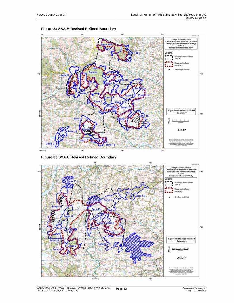
B5 Mynydd Penypistyll (Carno west)
This area is considered to have Medium-High landscape sensitivity. Wind development will impinge upon the setting of the Afon Twymyn valley and will be visible from the roads and settlements within. Limited inclusion of development extending from Zone B4 into this zone may be acceptable but would have to be kept back from the narrow ridge which is visible from the Afon Twymyn valley.
B6 Banwy Forest (Llyn Coch-hwyad)
Part of the land in the east of this zone is not considered suitable for wind development as it will impinge upon the setting of the Afon Banwy valley. Wind development in this area will be visible from settlements such as Foel and roads within the valley.
Part of the land in the north of this zone is not considered suitable for wind development as it will impinge upon the setting of the Afon Dugoed valley and will be visible from settlements and roads within the valley. Wind development in the north of the zone would dominate views out from the south of the National Park, due in part to proximity and topography. The steep north facing slopes in the north of the zone would mean wind development within this part of the zone would be highly visible from the National Park.
Land in the south west of this zone is not considered suitable for wind development due to the steeply sloping topography.
B7 Mynydd Lluest Fach
(Nant Carfan)
Land, generally comprising the steep sloped edges of this zone, is not considered suitable for wind development as it will impinge upon the setting of the Afon Tafalog, Nant Carfan and Clegyrnant valleys. Wind development in these areas will be visible from settlements and roads within the valleys.

Powys County Council Local refinement of TAN 8 Strategic Search Areas B and CReview Exercise
\\WACNAS04\JOBS\123000\123944-00\4 INTERNAL PROJECT DATA\4-50 REPORTS\FINAL REPORT_11.04.08.DOC
Page 26 Ove Arup & Partners LtdIssue 11 April 2008
Zone Zone name Justification for exclusion of areas
B8 Mynydd y Cemmaes The existing Mynydd y Cemais wind farm is located within this zone but land in the north of this zone was considered unsuitable for wind development as it will compromise the setting of Esgair Ddu. The steep slopes around the edge of this zone are also considered unsuitable for wind development as it would impinge upon the setting of the Afon Dyfi, Afon Tafalog and Nant Carfan valleys and settlements and roads located within them.
B9 Plynlimon Moorlands (east of Glaslyn)
This area is considered to have Medium-High landscape sensitivity. Wind development is considered unsuitable in this zone as it will impinge upon the setting of Foel Fadian and its associated crags and outcrops. Wind development would dominate the ground above the Wynford Vaughan Thomas memorial viewpoint and the scenic route along which it is located. Glyndŵr’s Way passes around the south of this zone.
B10a Dyfnant Forest (a) The steep slopes in the south of this zone are not considered suitable for wind development as it will impinge upon the setting of the Afon Twrch valley. Wind development in this area will be visible from settlements and roads within the Afon Twrch valley.
B10b Dyfnant Forest (b) The steep slopes in the south of this zone are not considered suitable for wind development as it will impinge upon the setting of the Afon Efyrnwy valley. Wind development in this area will be visible from settlements and roads within the Afon Efyrnwy valley. Glyndŵr’s Way passes through the north and west of this zone.
B11a Esgair Cwm Owen Uplands North (a)
The land in the north of this zone rises steeply and has a relatively complex visual composition which will be dominated by wind development. Wind development is not considered suitable in this area as it will impinge upon the setting of the Afon Gam and Afon Banwy valleys and will be visible from settlements and roads within these valleys. Crags and outcrops are present in the north of this area.
B11b Esgair Cwm Owen Uplands North (b)
The land in the north of this zone forms a visual continuation of the land in Zone B11a. Wind development is not considered suitable in this area as it will impinge upon the setting of the Afon Gam valley and will be visible from settlements and roads within this valley.
B11c Esgair Cwm Owen Uplands North (c)
The land in the north of this zone forms a visual continuation of the land in Zone B11a and B11b. Wind development is not considered suitable due to the steep topography in this area.
B11d Esgair Cwm Owen Uplands North (d)
Land in the north of this zone which forms a prominent hill above the Afon Gam valley is not considered suitable for wind development of any scale as it will impinge upon the setting of the valley. Wind development in this area will be visible from settlements and roads within the Afon Gam valley.
B11e Esgair Cwm Owen Uplands North (e)
No exclusions were made in this zone.

Powys County Council Local refinement of TAN 8 Strategic Search Areas B and CReview Exercise
\\WACNAS04\JOBS\123000\123944-00\4 INTERNAL PROJECT DATA\4-50 REPORTS\FINAL REPORT_11.04.08.DOC
Page 27 Ove Arup & Partners LtdIssue 11 April 2008
Zone Zone name Justification for exclusion of areas
B12 Esgair Cwm Owen Uplands West
The steep slopes in the south west of this zone are not considered suitable for wind development as it will impinge upon the setting of the Afon Iaen valley. Wind development in this area will be visible from settlements and roads within the Afon Iaen valley.
B13 Esgair Cwm Owen Uplands Central (Mynydd yr Hendre)
Land in the south of this zone is not considered suitable for wind development as it will impinge upon the setting of steeply rising Esgair Cwm Owen in Zone B14.
B14 Esgair Cwm Owen Uplands South (Garreg Hir)
This area is considered to have Medium-High landscape sensitivity. Wind development is considered unsuitable in this zone as it would impinge upon the setting of Garreg-hir and its associated crags and outcrops to the north. Wind development is also considered unsuitable on the narrow ridge of Esgair Cwm Owen.
B15 Esgair Cwm Owen Uplands East (Mynydd Clogau)
The existing Mynydd Clogau wind farm is located on the plateau top within this zone. The steep slopes around the edge of this zone are not considered suitable for wind development, as development in these locations would dominate the scale of the slopes and would be visible from settlements and roads located within the lower ground to the east.
B16 Clywedog Upland Wind development is considered unsuitable in this zone as it will impinge upon the setting of Foel Fadian and its associated crags and outcrops. Wind development would dominate the ground above the Wynford Vaughan Thomas memorial viewpoint and the scenic route along which it is located. Wind development is not considered suitable in this east of this area as it will impinge upon the setting of the Afon Twymyn valley and will be visible from settlements and roads within this valley.
B17 Trannon Woodlands No exclusions were made in this zone.
B18 Trannon and Carno Uplands – South-east
This area is considered to have Medium-High landscape sensitivity. Wind development would impinge upon the setting of the Afon Trannon valley and will be visible from the roads and settlements within. Limited inclusion of development extending from Zones B4 and B17 into this zone may be acceptable in the north of this zone.

Powys County Council Local refinement of TAN 8 Strategic Search Areas B and CReview Exercise
\\WACNAS04\JOBS\123000\123944-00\4 INTERNAL PROJECT DATA\4-50 REPORTS\FINAL REPORT_11.04.08.DOC
Page 28 Ove Arup & Partners LtdIssue 11 April 2008
Table 8b – Justification for areas of exclusion within SSA C
Zone Zone name Justification for exclusion of areas
C1 Kerry Hill and Clifaesty Hill
This zone is considered to have Medium-High landscape sensitivity. Wind development would impinge upon the setting of the Kerry Ridgeway, a prehistoric track which runs along a gently undulating ridge. Other features of historic interest in this zone include tumuli. Wind development would reduce the scale of Bryn Coch and Cilafaesty Hill two locally prominent rounded hills in the middle and south of the zone.
Limited inclusion of development extending from Zones C14, C2a and C2b into this zone may be acceptable in the east and west of this zone provided it would not compromise the setting of the above features.
C2a Banc Gorddwr (a) This zone is considered to have Medium-High landscape sensitivity. Wind development would reduce the apparent scale and impinge upon the setting of Glog in the north of the zone. Features of historic interest including tumuli are located on this hill.
Limited inclusion of development extending from Zone C2b into this zone may be acceptable in the south of this zone provided it would not compromise the setting of the above features.
C2b Banc Gorddwr (b) No exclusions were made in this zone.
C3 Bryn Gydfa The steep slopes in the east of this zone are not considered suitable for wind development. Wind development in these locations would dominate the scale of the slopes and would be visible from settlements and roads located in the Shropshire Hills AONB to the east.
C4 Pen-y-Bank North No exclusions were made in this zone.
C5 Rhiw Garn The steep slopes in the west of this zone are not considered suitable for wind development. Wind development in this location would dominate both the scale of the slopes and Afon Ieithon valley and would be visible from settlements and roads located on the lower ground to the west.
C6 Gors Lydan The steep slopes around the edge of this zone are not considered suitable for wind development. Wind development in these locations would dominate the scale of the slopes and would be visible from settlements and roads located within the surrounding lower ground. The zone also contains several hills including Warren Hill, Tylcau Hill and Tynybrynniau Hill. Wind development would dominate and reduce the apparent scale of these hills. Several features of historic interest including tumuli are located on these hills.
C7 Beacon Hill This zone is considered to have a Medium-High landscape sensitivity. Several prominent hills including Beacon Hill, Pool Hill, Stanky Hill and Black Mountain are located within this zone. Wind development would dominate and reduce the apparent scale of these hills. Several tumuli are located in the south of this zone.

Powys County Council Local refinement of TAN 8 Strategic Search Areas B and CReview Exercise
\\WACNAS04\JOBS\123000\123944-00\4 INTERNAL PROJECT DATA\4-50 REPORTS\FINAL REPORT_11.04.08.DOC
Page 29 Ove Arup & Partners LtdIssue 11 April 2008
Zone Zone name Justification for exclusion of areas
C8 Brondre Fawr Hill Land in the south east of this zone is not considered suitable for wind development as it will dominate the relatively small Ffrwd Wen valley. Wind development in this area will be visible from the scattered settlements and roads to the south.
C9 Lion Hill (Forest) Land in the south west of this zone is not considered suitable for wind development as it will dominate the relatively small Ffrwd Wen valley. Wind development in this area will be visible from the scattered settlements and roads to the south.
C10 Banc Du The steep slopes in the west and south west of the zone are considered unsuitable for wind development. Several historic features of interest inclosing Fowler’s Armchair SAM and Domen-ddu tumulus are present within this zone and careful consideration should be given to any wind development in close proximity to these features.
C11 Waun Dubarthog (Llandinam P&L east)
The existing P and L wind farm is located within this zone but land in the north of this zone is considered unsuitable for wind development as it will dominate and compromise the setting of the landform. Steep slopes in the west of the zone are also considered unsuitable as wind development would be visible from settlement and roads to the west.
C12 Blue Lins Brook No exclusions were made in this zone.
C13 Moel Lart This area is considered to have a Medium-High landscape sensitivity. Wind development within this area would dominate and compromise the setting of Moel Iart. Wind development would be visible in the settled valleys to the north, east and west of this zone.
C14 Kerry Ridgeway Forest Wind development would impinge upon the setting of the Kerry Ridgeway, a prehistoric track which runs along a gently undulating ridge. Other features of historic interest in this zone include tumuli. Wind development in this location would dominate the scale of the slopes to the north and would be visible from settlements including Kerry and roads located on the lower ground to the north.
C15 Cwmderw The steep slopes in the south of this zone are not considered suitable for wind development. Wind development in this location would dominate the scale of the slopes.
The extent of the land excluded from zones to protect of sensitive landscape features, foci and their setting from wind turbine development is illustrated in Figures 7a and 7b below.

Powys County Council Local refinement of TAN 8 Strategic Search Areas B and CReview Exercise
\\WACNAS04\JOBS\123000\123944-00\4 INTERNAL PROJECT DATA\4-50 REPORTS\FINAL REPORT_11.04.08.DOC
Page 30 Ove Arup & Partners LtdIssue 11 April 2008
Figure 7a SSA B Land considered for exclusion

Powys County Council Local refinement of TAN 8 Strategic Search Areas B and CReview Exercise
\\WACNAS04\JOBS\123000\123944-00\4 INTERNAL PROJECT DATA\4-50 REPORTS\FINAL REPORT_11.04.08.DOC
Page 31 Ove Arup & Partners LtdIssue 11 April 2008
Figure 7b SSA C Land considered for exclusion
Where edge and other landscape features are visually enclosed and the number of visual receptors is small ( i.e. a few scattered farms, limited visitor numbers etc. ) then these features have been considered for inclusion within the revised boundaries on the basis of their potential for limited landscape and visual impacts.
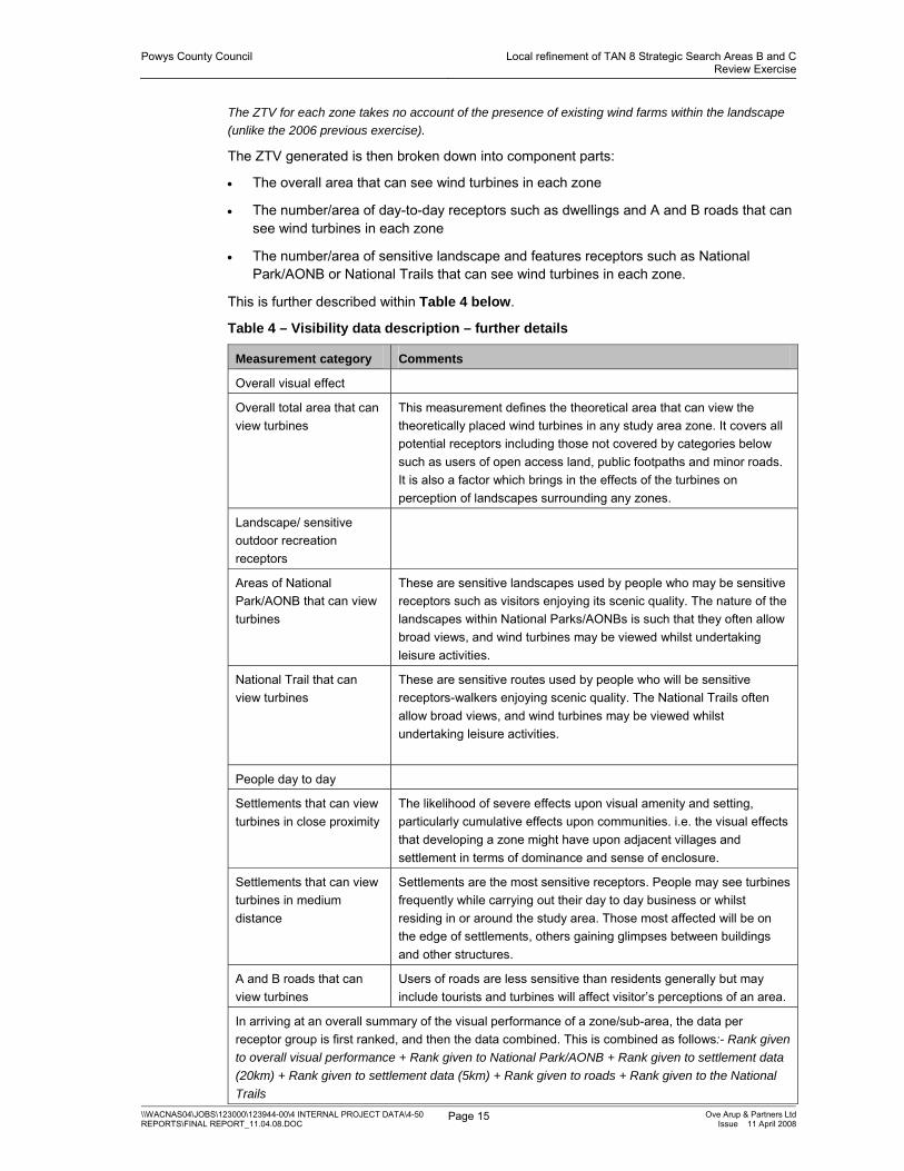
The revised refined boundaries were drawn taking into account landscape sensitivity, the visual analysis and the exclusion of sensitive landscape features; due consideration was also given to the inclusion of areas of lower wind speed. The revised refined boundaries for SSA B and SSA C are shown in Figures 8a and 8b respectively.
Powys County Council Local refinement of TAN 8 Strategic Search Areas B and CReview Exercise
\\WACNAS04\JOBS\123000\123944-00\4 INTERNAL PROJECT DATA\4-50 REPORTS\FINAL REPORT_11.04.08.DOC
Page 32 Ove Arup & Partners LtdIssue 11 April 2008
Figure 8a SSA B Revised Refined Boundary
Figure 8b SSA C Revised Refined Boundary

Powys County Council Local refinement of TAN 8 Strategic Search Areas B and CReview Exercise
\\WACNAS04\JOBS\123000\123944-00\4 INTERNAL PROJECT DATA\4-50 REPORTS\FINAL REPORT_11.04.08.DOC
Page 33 Ove Arup & Partners LtdIssue 11 April 2008
2.6 Comparison with 2006 draft IDCG refined boundaries
The revised refined boundaries for SSA B and C and the 2006 draft IDCG boundaries are shown on Figures 9a and 9b.
The main differences between the SSA B revised refined boundary and the SSA B 2006 draft IDCG boundary can be summarised as follows:
• The valley between Zone 8 and Zone 7 including steep slopes within these zones has not been included partially because of the low wind speeds within the valley and also to protect the setting of the Afon Tafalog valleys. Wind development in this area will be visible from settlements and roads within the valley.
• Some land within Zone 5 has not been included due to the landscape sensitivity of the zone and the potential effects on the Afon Twymyn valley, see Table 8a.
• Some land within Zone 14 has not been included due to the landscape sensitivity of the zone and the potential effects on the setting of Garreg Hir and Esgair Cwmowen, see Table 8a.
• Some land in Zone 18 has not been included due to the landscape sensitivity of the zone and the potential effects on the setting of Afon Trannon valley, see Table 8a.
• Land in Zones 10a and 10b, which was excluded from the 2006 draft IDCG boundary as it was not required to achieve the targets set for that study, has been included.
• Land in Zones 11a, 11b and 11e, which was excluded from the 2006 draft IDCG boundary as it was not required to achieve the targets set for that study, has been included.

Powys County Council Local refinement of TAN 8 Strategic Search Areas B and CReview Exercise
\\WACNAS04\JOBS\123000\123944-00\4 INTERNAL PROJECT DATA\4-50 REPORTS\FINAL REPORT_11.04.08.DOC
Page 34 Ove Arup & Partners LtdIssue 11 April 2008
Figure 9a SSA B Comparison between Revised Refined Boundary and the 2006 Draft IDCG Boundary
The main differences between the SSA C revised refined boundary and the SSA C 2006 draft IDCG boundary can be summarised as follows:
• Some land in Zone 13 and the extreme north of Zone 11 has not been included due to the landscape sensitivity of Zone 13 and the potential effects development in this location may have on Moel Iart, the River Severn valley and the settlement within this valley, see Table 8b.
• Some land in Zone 10 and Zone 15 including steep slopes within these zones has not been included and wind energy development would dominate the scale of the slopes. Some land has also been excluded to protect the setting of historic features within the area, see Table 8b.
• Some land within Zones 3, 5 and 9 has not been included to protect the setting of the incised valleys within these zones, see Table 8b.
• Land in Zones 2b, which was excluded from the 2006 draft IDCG boundary as it was not required to achieve the targets set for that study, has been included.
• Land between Zones 12 and 2b has been included within the revised refined boundary for SSA C following the consideration of lower wind speed as an absolute constraint for development, see Section 2.2.

Powys County Council Local refinement of TAN 8 Strategic Search Areas B and CReview Exercise
\\WACNAS04\JOBS\123000\123944-00\4 INTERNAL PROJECT DATA\4-50 REPORTS\FINAL REPORT_11.04.08.DOC
Page 35 Ove Arup & Partners LtdIssue 11 April 2008
Figure 9b SSA C Comparison between Revised Refined Boundary and the 2006 Draft IDCG Boundary
Overall the review of the refinement exercise has led to an increase in the area of land contained within the new refined boundaries when compared to the original refinement boundaries for both SSA B and SSA C.

Powys County Council Local refinement of TAN 8 Strategic Search Areas B and CReview Exercise
\\WACNAS04\JOBS\123000\123944-00\4 INTERNAL PROJECT DATA\4-50 REPORTS\FINAL REPORT_11.04.08.DOC
Page 36 Ove Arup & Partners LtdIssue 11 April 2008
3 Conclusions and recommendations 3.1 Study findings/Conclusions
In accordance with the brief, the review exercise has allowed the original (2006) refinement study for SSAs B and C to be updated with inputs from other Welsh Annex D studies, other wind farm development landscape sensitivity and capacity studies undertaken by the study team and consultee responses to the draft IDCG.
Two new boundaries result from the exercise. The revised refinement boundaries for SSA B and C are likely to be capable of accommodating a maximum of 806MW ±25MW and 345MW ± 25MW respectively, based on an estimated yield of 6.5MW/km2. It should be noted that these maximum capacities are based on developing the entire area within the revised SSA boundaries and would lead to significant cumulative effects in and around the SSA boundaries as well as the landscape change envisaged by TAN 8.
In accordance with the aspirations of TAN 8, it is recommended that these refined SSA B and C boundaries, rather than the published TAN 8 boundaries, form the basis for policy and plan-making within Powys County Council.

Appendix A Landscape Sensitivity Summary Sheets

Powys County Council Local refinement of TAN 8 Strategic Search Areas B and CReview Exercise
\\WACNAS04\JOBS\123000\123944-00\4 INTERNAL PROJECT DATA\4-50 REPORTS\FINAL REPORT_11.04.08.DOC
Page A1 Ove Arup & Partners LtdIssue 11 April 2008
A1 Landscape Sensitivity sheets for SSA B
POWYS WINDFARMS SSA B: Landscape sensitivity worksheet
AREA: B1A PENCOED UPLAND (EAST)
Generally criteria from better to worse for large scale windfarms, left to right.
Visual and Sensory
Criteria from LANDMAP assessment
PHYSICAL Topographic form
plateau rolling/undulating hills/valleys levels mountains
Landcover pattern
forestry open land field pattern/mosaic
development
Settlement pattern
no settlements
scattered/rural/farm clustered urban
AESTHETIC Scale of landform
vast large medium small intimate
Scale of landcover
vast large medium small intimate
Sense of enclosure
confined enclosed open exposed
Diversity uniform simple diverse complex PERCEPTUAL Level of
human access
rare occasional infrequent Frequent (in LANDMAP)
constant
Presence of attractive views
None Some Many
Presence of detractive views
Many Some None
Tranquillity Noisy Tranquil Remoteness Remote Settled [in
LANDMAP] Wildness Human
intervention Wild
Other criteria
Skyline smooth rounded complex
Skyline/ridge multiple (northern part
skyline to Afan Banwy)
single
Sensitive features
no sensitive features
(Some cairns) some sensitive features
features on skyline
Vertical elements
Many Masts and pylons
Some masts and pylons
No man made vertical elements
Landscape Character Sensitivity Summary Overall sensitivity
Low Medium-low Medium Medium-high High
Comments The area Is open, large scale, gently rounded upland hillsides with a simple skyline. The skyline is visible and on the edge of part of the Afon Banwy valley (to the north –Letty Ma is most prominent) a small area of forestry is included.

Powys County Council Local refinement of TAN 8 Strategic Search Areas B and CReview Exercise
\\WACNAS04\JOBS\123000\123944-00\4 INTERNAL PROJECT DATA\4-50 REPORTS\FINAL REPORT_11.04.08.DOC
Page A2 Ove Arup & Partners LtdIssue 11 April 2008
LANDMAP Landscape Value
Aspect
Visual and sensory
Low Moderate High Outstanding
Historic landscape
Low Moderate High Outstanding N/A
Biodiversity Low Moderate High Outstanding N/A Cultural Associations
Low Moderate High Outstanding N/A
Geology Low Moderate High Outstanding N/A Overall Value Low Moderate High Outstanding Irrelevant

Powys County Council Local refinement of TAN 8 Strategic Search Areas B and CReview Exercise
\\WACNAS04\JOBS\123000\123944-00\4 INTERNAL PROJECT DATA\4-50 REPORTS\FINAL REPORT_11.04.08.DOC
Page A3 Ove Arup & Partners LtdIssue 11 April 2008
POWYS WINDFARMS SSA B: Landscape sensitivity worksheet
AREA: B1B PENCOED UPLAND (WEST)
Generally criteria from better to worse for large scale windfarms, left to right.
Visual and Sensory
Criteria from LANDMAP assessment
PHYSICAL Topographic form
plateau rolling/undulating hills/valleys levels mountains
Landcover pattern
forestry open land field pattern/mosaic
development
Settlement pattern
no settlements
scattered/rural/farm clustered urban
AESTHETIC Scale of landform
vast large medium small intimate
Scale of landcover
vast large medium small intimate
Sense of enclosure
confined enclosed open exposed
Diversity uniform simple diverse complex PERCEPTUAL Level of
human access
rare occasional infrequent Frequent
constant
Presence of attractive views
None Some Many
Presence of detractive views
Many Some None
Tranquillity Noisy Tranquil Remoteness Remote Settled Wildness Human
intervention Wild
Other criteria
Skyline smooth rounded complex
Skyline/ridge multiple single
Sensitive features
no sensitive features
some sensitive features
features on skyline
Vertical elements
Many Masts and pylons
Some masts and pylons
No man made vertical elements
Landscape Character Sensitivity Summary Overall sensitivity
Low Medium-low Medium Medium-high High
Comments This area is open, large scale, gently undulating upland hillsides with a simple skyline. The area forms the south/east facing slopes facing the Nant Yr Eira Valley – a side of valley off the Afan Banwy.

Powys County Council Local refinement of TAN 8 Strategic Search Areas B and CReview Exercise
\\WACNAS04\JOBS\123000\123944-00\4 INTERNAL PROJECT DATA\4-50 REPORTS\FINAL REPORT_11.04.08.DOC
Page A4 Ove Arup & Partners LtdIssue 11 April 2008
LANDMAP Landscape Value
Aspect
Visual and sensory
Low Moderate High Outstanding
Historic landscape
Low Moderate High Outstanding N/A
Biodiversity Low Moderate High Outstanding N/A Cultural Associations
Low Moderate High Outstanding N/A
Geology Low Moderate High Outstanding N/A Overall Value Low Moderate High Outstanding Irrelevant

Powys County Council Local refinement of TAN 8 Strategic Search Areas B and CReview Exercise
\\WACNAS04\JOBS\123000\123944-00\4 INTERNAL PROJECT DATA\4-50 REPORTS\FINAL REPORT_11.04.08.DOC
Page A5 Ove Arup & Partners LtdIssue 11 April 2008
POWYS WINDFARMS SSA B: Landscape sensitivity worksheet
AREA: B2/B6 BANWY FOREST
Generally criteria from better to worse for large scale windfarms, left to right.
Visual and Sensory
Criteria from LANDMAP assessment
PHYSICAL Topographic form
plateau rolling/undulating hills/valleys levels mountains
Landcover pattern
forestry open land field pattern/mosaic
development
Settlement pattern
no settlements
scattered/rural/farm clustered urban
AESTHETIC Scale of landform
vast large medium small intimate
Scale of landcover
vast large medium small intimate
Sense of enclosure
confined enclosed open exposed
Diversity uniform simple diverse complex PERCEPTUAL Level of
human access
rare occasional infrequent Frequent
constant
Presence of attractive views
None Some Many
Presence of detractive views
Many Some (Single species)
None
Tranquillity Noisy Remoteness Remote Settled Wildness Human
intervention Wild
Other criteria
Skyline smooth rounded complex
Skyline/ridge multiple single
Sensitive features
no sensitive features
some sensitive features
features on skyline
Vertical elements
Many Masts and pylons
Some masts and pylons
No man made vertical elements (except forestry)
Landscape Character Sensitivity Summary Overall sensitivity
Low Medium-low Medium Medium-high High
Comments Landform single, relatively flat and featureless plateau top with rectangular forestry blocks on a large scale. These act as detractors in themselves. Some steep slopes on western and northern edge of 6 – more sensitive.

Powys County Council Local refinement of TAN 8 Strategic Search Areas B and CReview Exercise
\\WACNAS04\JOBS\123000\123944-00\4 INTERNAL PROJECT DATA\4-50 REPORTS\FINAL REPORT_11.04.08.DOC
Page A6 Ove Arup & Partners LtdIssue 11 April 2008
LANDMAP Landscape Value
Aspect
Visual and sensory
Low Moderate High Outstanding
Historic landscape
Low Moderate High Outstanding N/A
Biodiversity Low Moderate High Outstanding N/A Cultural Associations
Low Moderate High Outstanding N/A
Geology Low Moderate High Outstanding N/A Overall Value Low Moderate High Outstanding Irrelevant

Powys County Council Local refinement of TAN 8 Strategic Search Areas B and CReview Exercise
\\WACNAS04\JOBS\123000\123944-00\4 INTERNAL PROJECT DATA\4-50 REPORTS\FINAL REPORT_11.04.08.DOC
Page A7 Ove Arup & Partners LtdIssue 11 April 2008
POWYS WINDFARMS SSA B: Landscape sensitivity worksheet
AREA: B3 BANWY UPLAND
Generally criteria from better to worse for large scale windfarms, left to right.
Visual and Sensory
Criteria from LANDMAP assessment
PHYSICAL Topographic form
plateau rolling/undulating hills/valleys levels mountains
Landcover pattern
forestry open land field pattern/mosaic
Development (mixture)
Settlement pattern
no settlements
scattered/rural/farm clustered urban
AESTHETIC Scale of landform
vast large medium small intimate
Scale of landcover
vast large medium small intimate
Sense of enclosure
confined enclosed open exposed
Diversity uniform simple diverse complex PERCEPTUAL Level of
human access
rare occasional infrequent Frequent
constant
Presence of attractive views
None Some Many
Presence of detractive views
Many Some (Plantations are harsh)
None
Tranquillity Noisy Remoteness Remote Settled Wildness Human
intervention Wild
Other criteria
Skyline smooth rounded complex
Skyline/ridge multiple single
Sensitive features
no sensitive features
tumulus some sensitive features
features on skyline
Vertical elements
Many Masts and pylons
Some masts and pylons
No man made vertical elements
Landscape Character Sensitivity Summary Overall sensitivity
Low Medium-low Medium Medium-high High
Comments This large scale upland plateau fringe has a gently undulating form and a landcover of open moorland and grasses interspersed with blocks of coniferous plantations. It is relatively remote but the southern slopes border the Afon Iaen valley forming a transition from the more isolated plateau to the north. Views are possible across to the Trannon Moors and Cambrian Mountains to the south and west.

Powys County Council Local refinement of TAN 8 Strategic Search Areas B and CReview Exercise
\\WACNAS04\JOBS\123000\123944-00\4 INTERNAL PROJECT DATA\4-50 REPORTS\FINAL REPORT_11.04.08.DOC
Page A8 Ove Arup & Partners LtdIssue 11 April 2008
LANDMAP Landscape Value
Aspect
Visual and sensory
Low Moderate High Outstanding
Historic landscape
Low Moderate High Outstanding N/A
Biodiversity Low Moderate High Outstanding N/A Cultural Associations
Low Moderate High Outstanding N/A
Geology Low Moderate High Outstanding N/A Overall Value Low Moderate High Outstanding Irrelevant

Powys County Council Local refinement of TAN 8 Strategic Search Areas B and CReview Exercise
\\WACNAS04\JOBS\123000\123944-00\4 INTERNAL PROJECT DATA\4-50 REPORTS\FINAL REPORT_11.04.08.DOC
Page A9 Ove Arup & Partners LtdIssue 11 April 2008
POWYS WINDFARMS SSA B: Landscape sensitivity worksheet
AREA: B4 TRANNON MOORS
Generally criteria from better to worse for large scale windfarms, left to right.
Visual and Sensory
Criteria from LANDMAP assessment
PHYSICAL Topographic form
plateau rolling/undulating hills/valleys levels mountains
Landcover pattern
forestry open land field pattern/mosaic
development
Settlement pattern
no settlements
scattered/rural/farm clustered urban
AESTHETIC Scale of landform
vast large medium small intimate
Scale of landcover
vast large medium small intimate
Sense of enclosure
confined enclosed open exposed
Diversity uniform simple diverse complex PERCEPTUAL Level of
human access
rare occasional infrequent Frequent
constant
Presence of attractive views
None Some Many
Presence of detractive views
Many Some (dependent on view of wind turbines)
None
Tranquillity Noisy (Turbines) Remoteness Remote Settled Wildness Human
intervention Wild
Other criteria
Skyline smooth rounded complex
Skyline/ridge multiple Broad topped
ridge single
Sensitive features
no sensitive features
some sensitive features
features on skyline
Vertical elements
Many Masts and pylons
Wind farm carno Some masts and pylons
No man made vertical elements
Landscape Character Sensitivity Summary Overall sensitivity
Low Medium-low Medium Medium-high High
Comments This large scale upland plateau has a gently undulating form, a smooth skyline and a relatively simple landcover of open moorland and grasses. It is relatively remote with no settlement but the northern steeper sloping edges border the Afon Iaen valley. The area already has a large windfarm within it- Carno and forestry lies to the south [Area B17]. Northern edges with valley in which A470 is located are the most sensitive. Views are possible across to the plateau to the north and across to the P and L windfarm at Llandinam to the south east.

Powys County Council Local refinement of TAN 8 Strategic Search Areas B and CReview Exercise
\\WACNAS04\JOBS\123000\123944-00\4 INTERNAL PROJECT DATA\4-50 REPORTS\FINAL REPORT_11.04.08.DOC
Page A10 Ove Arup & Partners LtdIssue 11 April 2008
LANDMAP Landscape Value
Aspect
Visual and sensory
Low Moderate High Outstanding
Historic landscape
Low Moderate High Outstanding N/A
Biodiversity Low Moderate High Outstanding N/A Cultural Associations
Low Moderate High Outstanding N/A
Geology Low Moderate High Outstanding N/A Overall Value Low Moderate High Outstanding Irrelevant
Powys County Council Local refinement of TAN 8 Strategic Search Areas B and CReview Exercise
\\WACNAS04\JOBS\123000\123944-00\4 INTERNAL PROJECT DATA\4-50 REPORTS\FINAL REPORT_11.04.08.DOC
Page A11 Ove Arup & Partners LtdIssue 11 April 2008
POWYS WINDFARMS SSA B: Landscape sensitivity worksheet
AREA: B5 MYNYDD PENYPISTYLL
Generally criteria from better to worse for large scale windfarms, left to right.
Visual and Sensory
Criteria from LANDMAP assessment
PHYSICAL Topographic form
plateau rolling/undulating hills/valleys levels mountains
Landcover pattern
forestry open land field pattern/mosaic
development
Settlement pattern
no settlements
scattered/rural/farm clustered urban
AESTHETIC Scale of landform
vast large medium small intimate
Scale of landcover
vast large medium small intimate
Sense of enclosure
confined enclosed open exposed
Diversity uniform simple diverse complex PERCEPTUAL Level of
human access
rare occasional infrequent Frequent
constant
Presence of attractive views
None Some Many
Presence of detractive views
Many Some None
Tranquillity Noisy Windfarm at Carno nearby
Tranquil
Remoteness Remote Settled Wildness Human
intervention Wild
Other criteria
Skyline smooth rounded complex
Skyline/ridge multiple Single (narrow
ridge)
Sensitive features
no sensitive features
some sensitive features
features on skyline
Vertical elements
Many Masts and pylons
Some masts and pylons
No man made vertical elements
Landscape Character Sensitivity Summary Overall sensitivity
Low Medium-low Medium Medium-high High
Comments This narrow ridge with a varied skyline is a continuation of the Trannon Moors plateau to the east with a relatively simple landcover of open moorland and grasses. Coniferous forest covers part of the valley sides around Cwmcalch. The area is remote and has no settlement but the ridge is prominent in the Afon Twymyn valley to the west.
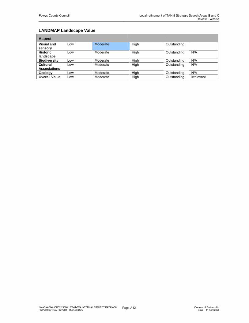
Powys County Council Local refinement of TAN 8 Strategic Search Areas B and CReview Exercise
\\WACNAS04\JOBS\123000\123944-00\4 INTERNAL PROJECT DATA\4-50 REPORTS\FINAL REPORT_11.04.08.DOC
Page A12 Ove Arup & Partners LtdIssue 11 April 2008
LANDMAP Landscape Value
Aspect
Visual and sensory
Low Moderate High Outstanding
Historic landscape
Low Moderate High Outstanding N/A
Biodiversity Low Moderate High Outstanding N/A Cultural Associations
Low Moderate High Outstanding N/A
Geology Low Moderate High Outstanding N/A Overall Value Low Moderate High Outstanding Irrelevant

Powys County Council Local refinement of TAN 8 Strategic Search Areas B and CReview Exercise
\\WACNAS04\JOBS\123000\123944-00\4 INTERNAL PROJECT DATA\4-50 REPORTS\FINAL REPORT_11.04.08.DOC
Page A13 Ove Arup & Partners LtdIssue 11 April 2008
POWYS WINDFARMS SSA B: Landscape sensitivity worksheet
AREA: B7 MYNYDD LLUEST FACH
Generally criteria from better to worse for large scale windfarms, left to right.
Visual and Sensory
Criteria from LANDMAP assessment
PHYSICAL Topographic form
plateau rolling/undulating hills/valleys levels mountains
Landcover pattern
forestry open land field pattern/mosaic
development
Settlement pattern
no settlements
scattered/rural/farm clustered urban
AESTHETIC Scale of landform
vast large medium small intimate
Scale of landcover
vast large medium small intimate
Sense of enclosure
confined enclosed open exposed
Diversity uniform simple diverse complex PERCEPTUAL Level of
human access
rare occasional infrequent Frequent
constant
Presence of attractive views
None Some Many
Presence of detractive views
Many Some None
Tranquillity Noisy Remoteness Remote Settled Wildness Human
intervention Wild
Other criteria
Skyline smooth rounded complex
Skyline/ridge multiple single
Sensitive features
no sensitive features
some sensitive features
features on skyline
Vertical elements
Many Masts and pylons
Some masts and pylons
No man made vertical elements
Landscape Character Sensitivity Summary Overall sensitivity
Low Medium-low Medium Medium-high High
Comments This upland plateau fringe has a gently undulating top and steep sides to the adjacent valleys [which are more sensitive] and a relatively simple landcover of open moorland and grasses. It is remote with no settlement or public rights of way. Views are possible to the National Park.

Powys County Council Local refinement of TAN 8 Strategic Search Areas B and CReview Exercise
\\WACNAS04\JOBS\123000\123944-00\4 INTERNAL PROJECT DATA\4-50 REPORTS\FINAL REPORT_11.04.08.DOC
Page A14 Ove Arup & Partners LtdIssue 11 April 2008
LANDMAP Landscape Value
Aspect
Visual and sensory
Low Moderate High Outstanding
Historic landscape
Low Moderate High Outstanding N/A
Biodiversity Low Moderate High Outstanding N/A Cultural Associations
Low Moderate High Outstanding N/A
Geology Low Moderate High Outstanding N/A Overall Value Low Moderate High Outstanding Irrelevant

Powys County Council Local refinement of TAN 8 Strategic Search Areas B and CReview Exercise
\\WACNAS04\JOBS\123000\123944-00\4 INTERNAL PROJECT DATA\4-50 REPORTS\FINAL REPORT_11.04.08.DOC
Page A15 Ove Arup & Partners LtdIssue 11 April 2008
POWYS WINDFARMS SSA B: Landscape sensitivity worksheet
AREA: B8 MYNNYD Y CEMMAES
Generally criteria from better to worse for large scale windfarms, left to right.
Visual and Sensory
Criteria from LANDMAP assessment
PHYSICAL Topographic form
plateau rolling/undulating hills/valleys levels mountains
Landcover pattern
forestry open land field pattern/mosaic
development
Settlement pattern
no settlements
scattered/rural/farm clustered urban
AESTHETIC Scale of landform
vast large medium small intimate
Scale of landcover
vast large medium small intimate
Sense of enclosure
confined enclosed open exposed
Diversity uniform simple diverse complex PERCEPTUAL Level of
human access
rare occasional infrequent Frequent
constant
Presence of attractive views
None Some Many
Presence of detractive views
Many Some None
Tranquillity Noisy (already some turbines)
Tranquil
Remoteness Remote Settled Wildness Human
intervention Wild
Other criteria
Skyline smooth rounded complex
Skyline/ridge multiple single
Sensitive features
no sensitive features
some sensitive features
features on skyline
Vertical elements
Many Masts and pylons [Existing Cemmaes Windfarm]
Some masts and pylons
No man made vertical elements

Powys County Council Local refinement of TAN 8 Strategic Search Areas B and CReview Exercise
\\WACNAS04\JOBS\123000\123944-00\4 INTERNAL PROJECT DATA\4-50 REPORTS\FINAL REPORT_11.04.08.DOC
Page A16 Ove Arup & Partners LtdIssue 11 April 2008
Landscape Character Sensitivity Summary Overall sensitivity
Low Medium-low Medium Medium-high High
Comments The area is a narrow ridge with a relatively even skyline and a simple landcover generally of open moorland and grasses with some conifer blocks on the slopes. There is an existing linear windfarm but no settlement. Esgair Ddu lies to the north as an outlying hill close to the Snowdonia National Park and is of high sensitivity. The area is relatively remote but the ridge is prominent in the Afon Dyfi valley to the west.
LANDMAP Landscape Value
Aspect
Visual and sensory
Low Moderate High Outstanding
Historic landscape
Low Moderate High Outstanding N/A
Biodiversity Low Moderate High Outstanding N/A Cultural Associations
Low Moderate High Outstanding N/A
Geology Low Moderate High Outstanding N/A Overall Value Low Moderate High Outstanding Irrelevant

Powys County Council Local refinement of TAN 8 Strategic Search Areas B and CReview Exercise
\\WACNAS04\JOBS\123000\123944-00\4 INTERNAL PROJECT DATA\4-50 REPORTS\FINAL REPORT_11.04.08.DOC
Page A17 Ove Arup & Partners LtdIssue 11 April 2008
POWYS WINDFARMS SSA B: Landscape sensitivity worksheet
AREA: B9 PLYNLIMON MOORLANDS
Generally criteria from better to worse for large scale windfarms, left to right.
Visual and Sensory
Criteria from LANDMAP assessment
PHYSICAL Topographic form
Plateau (should be)
rolling/undulating (landmap)
hills/valleys levels mountains
Landcover pattern
forestry open land field pattern/mosaic
development mixture
Settlement pattern
no settlements
scattered/rural/farm clustered urban
AESTHETIC Scale of landform
vast large medium small intimate
Scale of landcover
vast large medium small intimate
Sense of enclosure
confined enclosed open exposed
Diversity uniform simple diverse complex PERCEPTUAL Level of
human access
rare occasional infrequent Frequent
constant
Presence of attractive views
None Some Many[ to distant peaks]
Presence of detractive views
Many Some None
Tranquillity Noisy Tranquil Remoteness Remote Settled Wildness Human
intervention Wild
Other criteria
Skyline smooth rounded Slightly
complex undulations
complex
Skyline/ridge multiple single
Sensitive features
no sensitive features
some sensitive features
features on skyline
Vertical elements
Many Masts and pylons
Some masts and pylons
No man made vertical elements
Landscape Character Sensitivity Summary Overall sensitivity
Low Medium-low Medium Medium-high High
Comments This upland plateau landscape is an open moorland with a multiple slightly complex skyline and landcover of rough grasses with heather and bilberry patches. The area cuts across a conifer plantation. The scale is large and there are views to Plynlimon to the south. The area is exposed and relatively remote in feel although it is bounded by the Machynlleth to Staylittle road to the north which is a scenic route on which the Wynford Vaughan Thomas memorial viewpoint is located, just to the north west, and there is settlement to the east at Dylife. The nature reserve and lake at Glaslyn is adjacent to the west. Views are possible to the windfarms of Carno and P and L Llandinam to the east.

Powys County Council Local refinement of TAN 8 Strategic Search Areas B and CReview Exercise
\\WACNAS04\JOBS\123000\123944-00\4 INTERNAL PROJECT DATA\4-50 REPORTS\FINAL REPORT_11.04.08.DOC
Page A18 Ove Arup & Partners LtdIssue 11 April 2008
LANDMAP Landscape Value
Aspect
Visual and sensory
Low Moderate High Outstanding
Historic landscape
Low Moderate High Outstanding N/A
Biodiversity Low Moderate High Outstanding N/A Cultural Associations
Low Moderate High Outstanding N/A
Geology Low Moderate High Outstanding N/A Overall Value Low Moderate High Outstanding Irrelevant

Powys County Council Local refinement of TAN 8 Strategic Search Areas B and CReview Exercise
\\WACNAS04\JOBS\123000\123944-00\4 INTERNAL PROJECT DATA\4-50 REPORTS\FINAL REPORT_11.04.08.DOC
Page A19 Ove Arup & Partners LtdIssue 11 April 2008
POWYS WINDFARMS SSA B: Landscape sensitivity worksheet
AREA: B10A DYFNANT FOREST (WEST)
Generally criteria from better to worse for large scale windfarms, left to right.
Visual and Sensory
Criteria from LANDMAP assessment
PHYSICAL Topographic form
plateau rolling/undulating hills/valleys levels mountains
Landcover pattern
forestry open land field pattern/mosaic
development
Settlement pattern
no settlements
scattered/rural/farm clustered urban
AESTHETIC Scale of landform
Vast (LANDMAP)
large medium small intimate
Scale of landcover
vast large medium small intimate
Sense of enclosure
confined enclosed open exposed
Diversity uniform simple diverse complex PERCEPTUAL Level of
human access
rare occasional infrequent Frequent
constant
Presence of attractive views
None Some Many (to SNP)
Presence of detractive views
Many Some (clear felling areas)
None
Tranquillity Noisy Remoteness Remote Settled Wildness Human
intervention Wild
Other criteria
Skyline smooth rounded complex
Skyline/ridge multiple single
Sensitive features
no sensitive features
some sensitive features
features on skyline
Vertical elements
Many Masts and pylons
Some masts and pylons
No man made vertical elements (forestry only)
Landscape Character Sensitivity Summary Overall sensitivity
Low Medium-low Medium Medium-high High
Comments Rounded/undulating profile broad ridge with moderately sloping convex sides. The tops are covered with forest plantation some of which is felled. The scale of the land form is around 200m above the adjacent valley bottoms. The area lies close to the SNP but not close to sensitive receptors.

Powys County Council Local refinement of TAN 8 Strategic Search Areas B and CReview Exercise
\\WACNAS04\JOBS\123000\123944-00\4 INTERNAL PROJECT DATA\4-50 REPORTS\FINAL REPORT_11.04.08.DOC
Page A20 Ove Arup & Partners LtdIssue 11 April 2008
LANDMAP Landscape Value
Aspect
Visual and sensory
Low Moderate High Outstanding
Historic landscape
Low Moderate High Outstanding N/A
Biodiversity Low Moderate High Outstanding N/A Cultural Associations
Low Moderate High Outstanding N/A
Geology Low Moderate High Outstanding N/A Overall Value Low Moderate High Outstanding Irrelevant

Powys County Council Local refinement of TAN 8 Strategic Search Areas B and CReview Exercise
\\WACNAS04\JOBS\123000\123944-00\4 INTERNAL PROJECT DATA\4-50 REPORTS\FINAL REPORT_11.04.08.DOC
Page A21 Ove Arup & Partners LtdIssue 11 April 2008
POWYS WINDFARMS SSA B: Landscape sensitivity worksheet
AREA: B10B DYFNANT FOREST (EAST)
Generally criteria from better to worse for large scale windfarms, left to right.
Visual and Sensory
Criteria from LANDMAP assessment
PHYSICAL Topographic form
plateau rolling/undulating hills/valleys levels mountains
Landcover pattern
forestry open land field pattern/mosaic
development
Settlement pattern
no settlements
scattered/rural/farm clustered urban
AESTHETIC Scale of landform
Vast (LANDMAP)
large medium small intimate
Scale of landcover
vast large medium small intimate
Sense of enclosure
confined enclosed open exposed
Diversity uniform simple diverse complex PERCEPTUAL Level of
human access
rare occasional infrequent Frequent
constant
Presence of attractive views
None Some Many (to lower land to east especially)
Presence of detractive views
Many Some (clear felling areas)
None
Tranquillity Noisy Remoteness Remote Settled Wildness Human
intervention Wild
Other criteria
Skyline smooth rounded complex
Skyline/ridge multiple single
Sensitive features
no sensitive features
some sensitive features
features on skyline
Vertical elements
Many Masts and pylons
Some masts and pylons
No man made vertical elements (forestry only)
Landscape Character Sensitivity Summary Overall sensitivity
Low Medium-low Medium Medium-high High
Comments Rounded series of hills as part of a broad ridge, more pronounced than to the west with sloping sides, steep in places. The tops are covered with forest plantation some of which is felled. The tops rise around 170m above the adjacent valleys. The land falls gradually away to the east making this area somewhat exposed to views from lower areas.

Powys County Council Local refinement of TAN 8 Strategic Search Areas B and CReview Exercise
\\WACNAS04\JOBS\123000\123944-00\4 INTERNAL PROJECT DATA\4-50 REPORTS\FINAL REPORT_11.04.08.DOC
Page A22 Ove Arup & Partners LtdIssue 11 April 2008
LANDMAP Landscape Value
Aspect
Visual and sensory
Low Moderate High Outstanding
Historic landscape
Low Moderate High Outstanding N/A
Biodiversity Low Moderate High Outstanding N/A Cultural Associations
Low Moderate High Outstanding N/A
Geology Low Moderate High Outstanding N/A Overall Value Low Moderate High Outstanding Irrelevant

Powys County Council Local refinement of TAN 8 Strategic Search Areas B and CReview Exercise
\\WACNAS04\JOBS\123000\123944-00\4 INTERNAL PROJECT DATA\4-50 REPORTS\FINAL REPORT_11.04.08.DOC
Page A23 Ove Arup & Partners LtdIssue 11 April 2008
POWYS WINDFARMS SSA B: Landscape sensitivity worksheet
AREA: B11A DISGWYLFA
Generally criteria from better to worse for large scale windfarms, left to right.
Visual and Sensory
Criteria from LANDMAP assessment
PHYSICAL Topographic form
plateau rolling/undulating hills/valleys levels mountains
Landcover pattern
forestry open land field pattern/mosaic
development
Settlement pattern
no settlements
scattered/rural/farm clustered urban
AESTHETIC Scale of landform
vast large medium small intimate
Scale of landcover
vast large medium small intimate
Sense of enclosure
confined enclosed open exposed
Diversity uniform simple diverse complex PERCEPTUAL Level of
human access
rare occasional infrequent Frequent
constant
Presence of attractive views
None Some Many
Presence of detractive views
Many Some None
Tranquillity Noisy Tranquil Remoteness Remote Settled Wildness Human
intervention Wild
Other criteria
Skyline smooth rounded complex
Skyline/ridge multiple single
Sensitive features
no sensitive features
some sensitive features
features on skyline
Vertical elements
Many Masts and pylons
Some masts and pylons
No man made vertical elements
Landscape Character Sensitivity Summary Overall sensitivity
Low Medium-low Medium Medium-high High
Comments Northern end of extensive upland plateau forming a ridge with multiple hilltops in part. Open rough grazing landcover with occasional isolated woodland cover or tree belts. Steep slopes to NW and SE. Area overlooks Afan Banwy Valley.

Powys County Council Local refinement of TAN 8 Strategic Search Areas B and CReview Exercise
\\WACNAS04\JOBS\123000\123944-00\4 INTERNAL PROJECT DATA\4-50 REPORTS\FINAL REPORT_11.04.08.DOC
Page A24 Ove Arup & Partners LtdIssue 11 April 2008
LANDMAP Landscape Value
Aspect
Visual and sensory
Low Moderate High Outstanding
Historic landscape
Low Moderate High Outstanding N/A
Biodiversity Low Moderate High Outstanding N/A Cultural Associations
Low Moderate High Outstanding N/A
Geology Low Moderate High Outstanding N/A Overall Value Low Moderate High Outstanding Irrelevant

Powys County Council Local refinement of TAN 8 Strategic Search Areas B and CReview Exercise
\\WACNAS04\JOBS\123000\123944-00\4 INTERNAL PROJECT DATA\4-50 REPORTS\FINAL REPORT_11.04.08.DOC
Page A25 Ove Arup & Partners LtdIssue 11 April 2008
POWYS WINDFARMS SSA B: Landscape sensitivity worksheet
AREA: B11B MYNYDD WAUN FAWR
Generally criteria from better to worse for large scale windfarms, left to right.
Visual and Sensory
Criteria from LANDMAP assessment
PHYSICAL Topographic form
Plateau (should be)
rolling/undulating (LANDMAP)
hills/valleys levels mountains
Landcover pattern
forestry open land field pattern/mosaic
development
Settlement pattern
no settlements
scattered/rural/farm clustered urban
AESTHETIC Scale of landform
vast large medium small intimate
Scale of landcover
vast large medium small intimate
Sense of enclosure
confined enclosed open exposed
Diversity uniform simple diverse complex PERCEPTUAL Level of
human access
rare occasional infrequent Frequent
constant
Presence of attractive views
None Some Many
Presence of detractive views
Many Some None
Tranquillity Noisy Tranquil Remoteness Remote Settled Wildness Human
intervention Wild
Other criteria
Skyline smooth rounded complex
Skyline/ridge multiple single
Sensitive features
no sensitive features
some sensitive features
features on skyline
Vertical elements
Many Masts and pylons
Some masts and pylons
[two dwellings]
No man made vertical elements
Landscape Character Sensitivity Summary Overall sensitivity
Low Medium-low Medium Medium-high High
Comments Part of an extensive upland plateau with relatively smooth skyline and moderately steep to the north east which are more sensitive. Open rough grazing landcover with isolated conifer blocks and upland water bodies. Area overlooks minor valley of Nant yr Eira.

Powys County Council Local refinement of TAN 8 Strategic Search Areas B and CReview Exercise
\\WACNAS04\JOBS\123000\123944-00\4 INTERNAL PROJECT DATA\4-50 REPORTS\FINAL REPORT_11.04.08.DOC
Page A26 Ove Arup & Partners LtdIssue 11 April 2008
LANDMAP Landscape Value
Aspect
Visual and sensory
Low Moderate High Outstanding
Historic landscape
Low Moderate High Outstanding N/A
Biodiversity Low Moderate High Outstanding N/A Cultural Associations
Low Moderate High Outstanding N/A
Geology Low Moderate High Outstanding N/A Overall Value Low Moderate High Outstanding Irrelevant

Powys County Council Local refinement of TAN 8 Strategic Search Areas B and CReview Exercise
\\WACNAS04\JOBS\123000\123944-00\4 INTERNAL PROJECT DATA\4-50 REPORTS\FINAL REPORT_11.04.08.DOC
Page A27 Ove Arup & Partners LtdIssue 11 April 2008
POWYS WINDFARMS SSA B: Landscape sensitivity worksheet
AREA: B11C MYNYDD LLUEST-Y-GRAIG
Generally criteria from better to worse for large scale windfarms, left to right.
Visual and Sensory
Criteria from LANDMAP assessment
PHYSICAL Topographic form
Plateau (should be)
rolling/undulating (LANDMAP)
hills/valleys levels mountains
Landcover pattern
forestry open land field pattern/mosaic
development
Settlement pattern
no settlements
scattered/rural/farm clustered urban
AESTHETIC Scale of landform
vast large medium small intimate
Scale of landcover
vast large medium small intimate
Sense of enclosure
confined enclosed open exposed
Diversity uniform simple diverse complex PERCEPTUAL Level of
human access
rare occasional infrequent Frequent
constant
Presence of attractive views
None Some Many
Presence of detractive views
Many Some None
Tranquillity Noisy Tranquil Remoteness Remote Settled Wildness Human
intervention Wild
Other criteria
Skyline smooth rounded complex
Skyline/ridge multiple single
Sensitive features
no sensitive features
some sensitive features
features on skyline
Vertical elements
Many Masts and pylons
Some masts and pylons
No man made vertical elements
Landscape Character Sensitivity Summary Overall sensitivity
Low Medium-low Medium Medium-high High
Comments Part of an extensive simple upland plateau with smooth skyline with steep slopes at one point facing north west which is more sensitive. Open rough grazing land cover with isolated conifer blocks.

Powys County Council Local refinement of TAN 8 Strategic Search Areas B and CReview Exercise
\\WACNAS04\JOBS\123000\123944-00\4 INTERNAL PROJECT DATA\4-50 REPORTS\FINAL REPORT_11.04.08.DOC
Page A28 Ove Arup & Partners LtdIssue 11 April 2008
LANDMAP Landscape Value
Aspect
Visual and sensory
Low Moderate High Outstanding
Historic landscape
Low Moderate High Outstanding N/A
Biodiversity Low Moderate High Outstanding N/A Cultural Associations
Low Moderate High Outstanding N/A
Geology Low Moderate High Outstanding N/A Overall Value Low Moderate High Outstanding Irrelevant

Powys County Council Local refinement of TAN 8 Strategic Search Areas B and CReview Exercise
\\WACNAS04\JOBS\123000\123944-00\4 INTERNAL PROJECT DATA\4-50 REPORTS\FINAL REPORT_11.04.08.DOC
Page A29 Ove Arup & Partners LtdIssue 11 April 2008
POWYS WINDFARMS SSA B: Landscape sensitivity worksheet
AREA: B11D – TRWYN-Y-BRYN
Generally criteria from better to worse for large scale windfarms, left to right.
Visual and Sensory
Criteria from LANDMAP assessment
PHYSICAL Topographic form
Plateau (should be)
rolling/undulating (landmap)
hills/valleys levels mountains
Landcover pattern
forestry open land field pattern/mosaic (In parts to the north)
development
Settlement pattern
no settlements
scattered/rural/farm clustered urban
AESTHETIC Scale of landform
vast large medium small intimate
Scale of landcover
vast large medium small intimate
Sense of enclosure
confined enclosed open exposed
Diversity uniform simple diverse complex PERCEPTUAL Level of
human access
rare occasional infrequent Frequent
constant
Presence of attractive views
None Some Many
Presence of detractive views
Many Some None
Tranquillity Noisy Tranquil Remoteness Remote Settled Wildness Human
intervention Wild
Other criteria
Skyline smooth rounded complex
Skyline/ridge multiple single
Sensitive features
no sensitive features
some sensitive features
features on skyline
Vertical elements
Many Masts and pylons
Some masts and pylons
Forest No man made vertical elements
Landscape Character Sensitivity Summary Overall sensitivity
Low Medium-low Medium Medium-high High
Comments
LANDMAP Landscape Value
Aspect
Visual and Low Moderate High Outstanding

Powys County Council Local refinement of TAN 8 Strategic Search Areas B and CReview Exercise
\\WACNAS04\JOBS\123000\123944-00\4 INTERNAL PROJECT DATA\4-50 REPORTS\FINAL REPORT_11.04.08.DOC
Page A30 Ove Arup & Partners LtdIssue 11 April 2008
sensory Historic landscape
Low Moderate High Outstanding N/A
Biodiversity Low Moderate High Outstanding N/A Cultural Associations
Low Moderate High Outstanding N/A
Geology Low Moderate High Outstanding N/A Overall Value Low Moderate High Outstanding Irrelevant

Powys County Council Local refinement of TAN 8 Strategic Search Areas B and CReview Exercise
\\WACNAS04\JOBS\123000\123944-00\4 INTERNAL PROJECT DATA\4-50 REPORTS\FINAL REPORT_11.04.08.DOC
Page A31 Ove Arup & Partners LtdIssue 11 April 2008
POWYS WINDFARMS SSA B: Landscape sensitivity worksheet
AREA: B11E FOELFAWR
Generally criteria from better to worse for large scale windfarms, left to right.
Visual and Sensory
Criteria from LANDMAP assessment
PHYSICAL Topographic form
Plateau (should be)
rolling/undulating (landmap)
hills/valleys levels mountains
Landcover pattern
forestry open land [LANDMAP]
field pattern/mosaic [some]
development
Settlement pattern
no settlements [LANDMAP]
scattered/rural/farm clustered urban
AESTHETIC Scale of landform
vast large medium small intimate
Scale of landcover
vast large medium small intimate
Sense of enclosure
confined enclosed open exposed
Diversity uniform simple diverse complex PERCEPTUAL Level of
human access
rare occasional infrequent Frequent
constant
Presence of attractive views
None Some Many
Presence of detractive views
Many Some None
Tranquillity Noisy Tranquil Remoteness Remote Settled Wildness Human
intervention Wild
Other criteria
Skyline smooth rounded complex
Skyline/ridge multiple single
Sensitive features
no sensitive features
some sensitive features
features on skyline
Vertical elements
Many Masts and pylons
Some masts and pylons
No man made vertical elements
Landscape Character Sensitivity Summary Overall sensitivity
Low Medium-low Medium Medium-high High
Comments Upland plateau with smooth simple skyline of open rough grazing and some enclosure with some settlement and a minor road. Slopes to enclosed Afon Rhiw Valley to south east less sensitive to north away from settlement.

Powys County Council Local refinement of TAN 8 Strategic Search Areas B and CReview Exercise
\\WACNAS04\JOBS\123000\123944-00\4 INTERNAL PROJECT DATA\4-50 REPORTS\FINAL REPORT_11.04.08.DOC
Page A32 Ove Arup & Partners LtdIssue 11 April 2008
LANDMAP Landscape Value
Aspect
Visual and sensory
Low Moderate High Outstanding
Historic landscape
Low Moderate High Outstanding N/A
Biodiversity Low Moderate High Outstanding N/A Cultural Associations
Low Moderate High Outstanding N/A
Geology Low Moderate High Outstanding N/A Overall Value Low Moderate High Outstanding Irrelevant

Powys County Council Local refinement of TAN 8 Strategic Search Areas B and CReview Exercise
\\WACNAS04\JOBS\123000\123944-00\4 INTERNAL PROJECT DATA\4-50 REPORTS\FINAL REPORT_11.04.08.DOC
Page A33 Ove Arup & Partners LtdIssue 11 April 2008
POWYS WINDFARMS SSA B: Landscape sensitivity worksheet
AREA: B12-B15 ESGAIR CYMOWEN UPLANDS
Generally criteria from better to worse for large scale windfarms, left to right.
Visual and Sensory
Criteria from LANDMAP assessment
PHYSICAL Topographic form
Plateau (should be)
rolling/undulating hills/valleys levels mountains
Landcover pattern
forestry open land field pattern/mosaic
development
Settlement pattern
no settlements
scattered/rural/farm clustered urban
AESTHETIC Scale of landform
vast large medium small intimate
Scale of landcover
vast large medium small intimate
Sense of enclosure
confined enclosed open exposed
Diversity uniform simple diverse complex PERCEPTUAL Level of
human access
rare occasional infrequent Frequent
constant
Presence of attractive views
None Some Many
Presence of detractive views
Many Some None
Tranquillity Noisy Tranquil Remoteness Remote Settled Wildness Human
intervention Wild
Other criteria
Skyline Smooth (In places)
rounded [Garreg Hir] complex
Skyline/ridge multiple single
Sensitive features
no sensitive features
some sensitive features
features on skyline (Garreg Hir- cairns, stone circles, rock outcrops)
Vertical elements
Many Masts and pylons
Some masts and pylons
No man made vertical elements
Landscape Character Sensitivity Summary Overall sensitivity
Low Medium-low Medium [upland fringes]
Medium-high [Garreg Hir]
High
Comments Extensive area of upland plateau with steep valley sides. Used for upland grazing with simple landcover and a few isolated areas of conifer plantation. Mainly grass with some moorland vegetation. Sensitivity varies across the area- Garreg Hir is intrinsically sensitive as are edges and steep slopes.

Powys County Council Local refinement of TAN 8 Strategic Search Areas B and CReview Exercise
\\WACNAS04\JOBS\123000\123944-00\4 INTERNAL PROJECT DATA\4-50 REPORTS\FINAL REPORT_11.04.08.DOC
Page A34 Ove Arup & Partners LtdIssue 11 April 2008
LANDMAP Landscape Value
Aspect
Visual and sensory
Low Moderate High Outstanding
Historic landscape
Low Moderate High Outstanding N/A
Biodiversity Low Moderate High Outstanding N/A Cultural Associations
Low Moderate High Outstanding N/A
Geology Low Moderate High Outstanding N/A Overall Value Low Moderate High Outstanding Irrelevant

Powys County Council Local refinement of TAN 8 Strategic Search Areas B and CReview Exercise
\\WACNAS04\JOBS\123000\123944-00\4 INTERNAL PROJECT DATA\4-50 REPORTS\FINAL REPORT_11.04.08.DOC
Page A35 Ove Arup & Partners LtdIssue 11 April 2008
POWYS WINDFARMS SSA B: Landscape sensitivity worksheet
AREA: B16 CLYWEDOG UPLANDS GRAZING
Generally criteria from better to worse for large scale windfarms, left to right.
Visual and Sensory
Criteria from LANDMAP assessment
PHYSICAL Topographic form
Plateau (should be)
rolling/undulating (landmap)
hills/valleys levels mountains
Landcover pattern
forestry open land field pattern/mosaic
development mixture
Settlement pattern
no settlements
scattered/rural/farm clustered urban
AESTHETIC Scale of landform
vast large medium small intimate
Scale of landcover
vast large medium small intimate
Sense of enclosure
confined enclosed open exposed
Diversity uniform simple diverse complex PERCEPTUAL Level of
human access
rare occasional infrequent Frequent
constant
Presence of attractive views
None Some Many
Presence of detractive views
Many Some None
Tranquillity Noisy Tranquil Remoteness Remote Settled Wildness Human
intervention Wild?
Other criteria
Skyline smooth rounded complex
Skyline/ridge multiple single
Sensitive features
no sensitive features
some sensitive features
features on skyline
Vertical elements
Many Masts and pylons
Some masts and pylons
No man made vertical elements
Landscape Character Sensitivity Summary Overall sensitivity
Low Medium-low Medium Medium-high High
Comments This elevated rolling upland landscape has a rounded form interspersed with drainage gullies and a relatively simple landcover of improved grassland. The scale is large although the ridge to valley height is around 100m. Enclosure is minimal. It is exposed and relatively remote in feel although it is crossed by the Machynlleth to Staylittle road which is a scenic route on which the Wynford Vaughan Thomas memorial viewpoint is located, just to the west, and there is settlement to the east at Dylife. Views are possible to Snowdonia to the west, and to the windfarms of Carno and P and L Llandinam to the east. Areaon north western fringe is high sensitivity due to its proximity to the Wynford Vaughan Thomas Memorial

Powys County Council Local refinement of TAN 8 Strategic Search Areas B and CReview Exercise
\\WACNAS04\JOBS\123000\123944-00\4 INTERNAL PROJECT DATA\4-50 REPORTS\FINAL REPORT_11.04.08.DOC
Page A36 Ove Arup & Partners LtdIssue 11 April 2008
LANDMAP Landscape Value
Aspect
Visual and sensory
Low Moderate High Outstanding
Historic landscape
Low Moderate High Outstanding N/A
Biodiversity Low Moderate High Outstanding N/A Cultural Associations
Low Moderate High Outstanding N/A
Geology Low Moderate High Outstanding N/A Overall Value Low Moderate High Outstanding Irrelevant

Powys County Council Local refinement of TAN 8 Strategic Search Areas B and CReview Exercise
\\WACNAS04\JOBS\123000\123944-00\4 INTERNAL PROJECT DATA\4-50 REPORTS\FINAL REPORT_11.04.08.DOC
Page A37 Ove Arup & Partners LtdIssue 11 April 2008
POWYS WINDFARMS SSA B: Landscape sensitivity worksheet
AREA: B17 TRANNON WOODLANDS [FOREST PLANTATION]
Generally criteria from better to worse for large scale windfarms, left to right.
Visual and Sensory
Criteria from LANDMAP assessment
PHYSICAL Topographic form
Plateau rolling/undulating (landmap)
hills/valleys levels mountains
Landcover pattern
forestry open land field pattern/mosaic
development mixture
Settlement pattern
no settlements
scattered/rural/farm clustered urban
AESTHETIC Scale of landform
vast large medium small intimate
Scale of landcover
vast large medium small intimate
Sense of enclosure
confined enclosed open exposed
Diversity uniform simple diverse complex PERCEPTUAL Level of
human access
rare occasional infrequent Frequent
constant
Presence of attractive views
None Some [out] Many
Presence of detractive views
Many Some [in] None
Tranquillity Noisy Tranquil Remoteness Remote Settled Wildness Human
intervention Wild?
Other criteria
Skyline smooth rounded complex
Skyline/ridge multiple single
Sensitive features
no sensitive features
some sensitive features
features on skyline
Vertical elements
Many Masts and pylons
Some masts and pylons
No man made vertical elements
Landscape Character Sensitivity Summary Overall sensitivity
Low Medium-low Medium Medium-high High
Comments

Powys County Council Local refinement of TAN 8 Strategic Search Areas B and CReview Exercise
\\WACNAS04\JOBS\123000\123944-00\4 INTERNAL PROJECT DATA\4-50 REPORTS\FINAL REPORT_11.04.08.DOC
Page A38 Ove Arup & Partners LtdIssue 11 April 2008
LANDMAP Landscape Value
Aspect
Visual and sensory
Low Moderate High Outstanding
Historic landscape
Low Moderate High Outstanding N/A
Biodiversity Low Moderate High Outstanding N/A Cultural Associations
Low Moderate High Outstanding N/A
Geology Low Moderate High Outstanding N/A Overall Value Low Moderate High Outstanding Irrelevant

Powys County Council Local refinement of TAN 8 Strategic Search Areas B and CReview Exercise
\\WACNAS04\JOBS\123000\123944-00\4 INTERNAL PROJECT DATA\4-50 REPORTS\FINAL REPORT_11.04.08.DOC
Page A39 Ove Arup & Partners LtdIssue 11 April 2008
POWYS WINDFARMS SSA B: Landscape sensitivity worksheet
AREA: B18 TRANNON AND CARNO UPLANDS
Generally criteria from better to worse for large scale windfarms, left to right.
Visual and Sensory
Criteria from LANDMAP assessment
PHYSICAL Topographic form
Plateau (should be)
rolling/undulating (landmap)
hills/valleys levels mountains
Landcover pattern
forestry open land field pattern/mosaic
development mixture
Settlement pattern
no settlements
scattered/rural/farm clustered urban
AESTHETIC Scale of landform
vast large medium small intimate
Scale of landcover
vast large medium small intimate
Sense of enclosure
confined enclosed open exposed
Diversity uniform simple diverse complex PERCEPTUAL Level of
human access
rare occasional infrequent Frequent
constant
Presence of attractive views
None Some Many
Presence of detractive views
Many Some None
Tranquillity Noisy Tranquil Remoteness Remote Settled Wildness Human
intervention Wild
Other criteria
Skyline smooth rounded complex
Skyline/ridge multiple single
Sensitive features
no sensitive features
some sensitive features
features on skyline
Vertical elements
Many Masts and pylons
Some masts and pylons
No man made vertical elements
Landscape Character Sensitivity Summary Overall sensitivity
Low Medium-low Medium Medium-high High
Comments
LANDMAP Landscape Value
Aspect
Visual and sensory
Low Moderate High Outstanding
Historic Low Moderate High Outstanding N/A

Powys County Council Local refinement of TAN 8 Strategic Search Areas B and CReview Exercise
\\WACNAS04\JOBS\123000\123944-00\4 INTERNAL PROJECT DATA\4-50 REPORTS\FINAL REPORT_11.04.08.DOC
Page A40 Ove Arup & Partners LtdIssue 11 April 2008
landscape Biodiversity Low Moderate High Outstanding N/A Cultural Associations
Low Moderate High Outstanding N/A
Geology Low Moderate High Outstanding N/A Overall Value Low Moderate High Outstanding Irrelevant

Powys County Council Local refinement of TAN 8 Strategic Search Areas B and CReview Exercise
\\WACNAS04\JOBS\123000\123944-00\4 INTERNAL PROJECT DATA\4-50 REPORTS\FINAL REPORT_11.04.08.DOC
Page A41 Ove Arup & Partners LtdIssue 11 April 2008
A2 Landscape Sensitivity sheets for SSA C
POWYS WINDFARMS SSA C: Landscape sensitivity worksheet
AREA: C1 KERRY RIDGEWAY
Generally criteria from better to worse for large scale windfarms, left to right.
Visual and Sensory
Criteria from LANDMAP assessment
PHYSICAL Topographic form
plateau rolling/undulating hills/valleys levels mountains
Landcover pattern
forestry open land field pattern/mosaic
development
Settlement pattern
no settlements
scattered/rural/farm clustered urban
AESTHETIC Scale of landform
vast Large medium small intimate
Scale of landcover
vast Large medium small intimate
Sense of enclosure
confined Enclosed open exposed
Diversity uniform Simple diverse complex PERCEPTUAL Level of
human access
rare Occasional infrequent frequent constant
Presence of attractive views
None Some [To farming to north To upland to south]
Many
Presence of detractive views
Many Some None
Tranquillity Noisy Tranquil Remoteness Remote Settled Wildness Human
intervention Wild
Other criteria
Skyline smooth rounded complex
Skyline/ridge multiple Kerry
Ridgeway + 2 other hills]
single
Sensitive features
no sensitive features
some sensitive features [Two tumps, cross dyke and ridgeway]
features on skyline
Vertical elements
Many Masts and pylons
Some masts and pylons
No man made vertical elements

Powys County Council Local refinement of TAN 8 Strategic Search Areas B and CReview Exercise
\\WACNAS04\JOBS\123000\123944-00\4 INTERNAL PROJECT DATA\4-50 REPORTS\FINAL REPORT_11.04.08.DOC
Page A42 Ove Arup & Partners LtdIssue 11 April 2008
Landscape Character Sensitivity Summary Overall sensitivity
Low Medium-low Medium Medium-high High
Comments Kerry Hill is part of a gently undulating ridge which runs to the south of the Severn valley and is known for the prehistoric track along it called the Kerry Ridgeway which starts in this area. Zone C1 landcover on the hill is a primarily grassland with some heath and with limited coniferous plantation to the east and some tree enclosure to the west. There is evidence of prehistoric remains including a cross dyke and tumps. Cilfaesty Hill and Bryn Coch to the south form two distinct rounded hills covered in heath and bracken. The area is tranquil although the area is bounded by a road to the south and west. There is no settlement. Views are possible to the AONB to the east.
LANDMAP Landscape Value
Aspect
Visual and sensory
Low Moderate High Outstanding
History and Archaeology
Low Moderate High Outstanding N/A
Biodiversity Low Moderate High Outstanding N/A Cultural associations
Low Moderate High Outstanding N/A
Geology Low Moderate High Outstanding N/A Overall Value Low Moderate High Outstanding Irrelevant

Powys County Council Local refinement of TAN 8 Strategic Search Areas B and CReview Exercise
\\WACNAS04\JOBS\123000\123944-00\4 INTERNAL PROJECT DATA\4-50 REPORTS\FINAL REPORT_11.04.08.DOC
Page A43 Ove Arup & Partners LtdIssue 11 April 2008
POWYS WINDFARMS SSA C: Landscape sensitivity worksheet
AREA: C2A BANC CEFNPERFEDD
Generally criteria from better to worse for large scale windfarms, left to right.
Visual and Sensory
Criteria from LANDMAP assessment
PHYSICAL Topographic form
plateau rolling/undulating hills/valleys levels mountains
Landcover pattern
forestry open land field pattern/mosaic
development
Settlement pattern
no settlements
scattered/rural/farm clustered urban
AESTHETIC Scale of landform
vast Large medium small intimate
Scale of landcover
vast Large medium small intimate
Sense of enclosure
confined Enclosed open exposed
Diversity uniform Simple diverse complex PERCEPTUAL Level of
human access
rare Occasional infrequent frequent constant
Presence of attractive views
None Some Many
Presence of detractive views
Many Some None
Tranquillity Noisy Tranquil Remoteness Remote Settled Wildness Human
intervention Wild
Other criteria
Skyline smooth rounded complex
Skyline/ridge multiple single
Sensitive features
no sensitive features
some sensitive features [tumuli]
features on skyline
Vertical elements
Many Masts and pylons
Some masts and pylons
No man made vertical elements
Landscape Character Sensitivity Summary Overall sensitivity
Low Medium-low Medium Medium-high High
Comments Northern ridge is sensitive as the west is narrow with a varied profile. Some features of historic interest on ridge tops including tumuli. Generally the land cover is open with occasional conifer/beech belts. Steep slopes border the north and west of the area and it lies on the edge of settled lower land to the north.
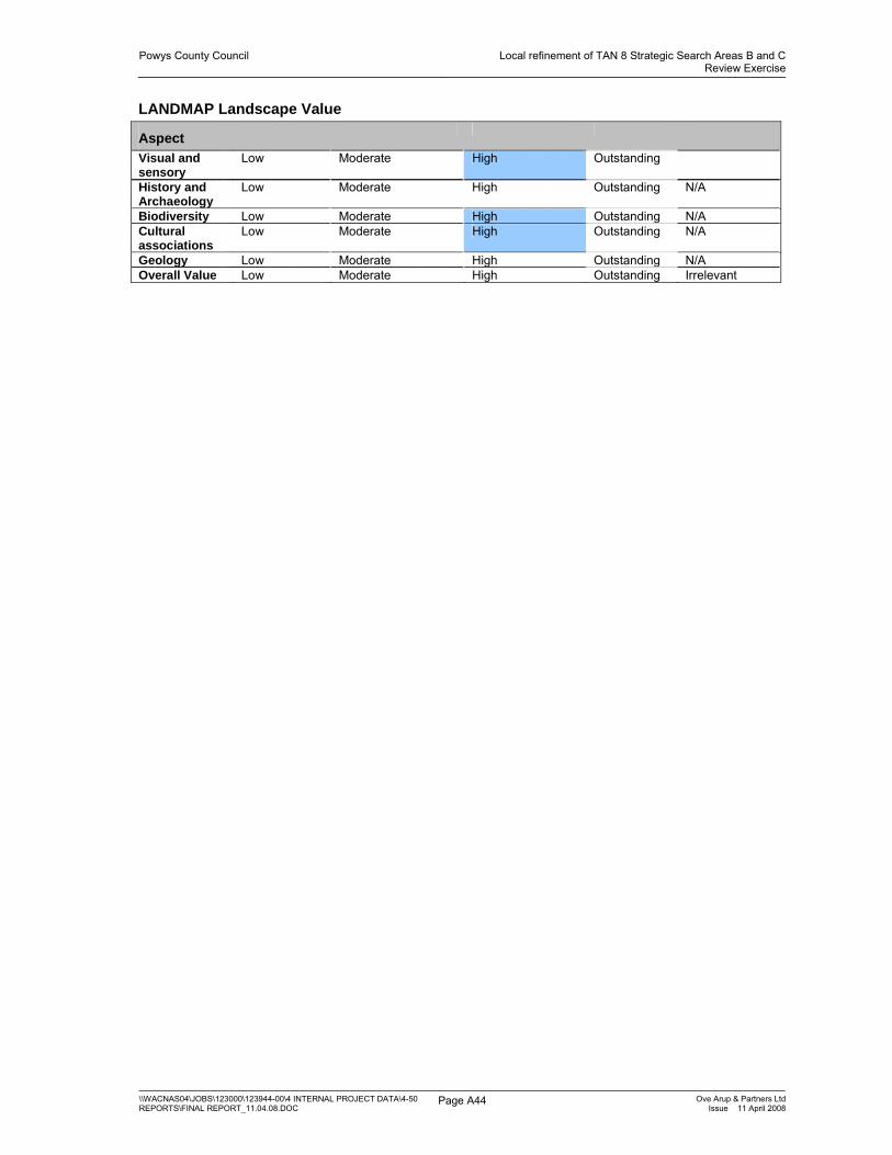
Powys County Council Local refinement of TAN 8 Strategic Search Areas B and CReview Exercise
\\WACNAS04\JOBS\123000\123944-00\4 INTERNAL PROJECT DATA\4-50 REPORTS\FINAL REPORT_11.04.08.DOC
Page A44 Ove Arup & Partners LtdIssue 11 April 2008
LANDMAP Landscape Value
Aspect
Visual and sensory
Low Moderate High Outstanding
History and Archaeology
Low Moderate High Outstanding N/A
Biodiversity Low Moderate High Outstanding N/A Cultural associations
Low Moderate High Outstanding N/A
Geology Low Moderate High Outstanding N/A Overall Value Low Moderate High Outstanding Irrelevant

Powys County Council Local refinement of TAN 8 Strategic Search Areas B and CReview Exercise
\\WACNAS04\JOBS\123000\123944-00\4 INTERNAL PROJECT DATA\4-50 REPORTS\FINAL REPORT_11.04.08.DOC
Page A45 Ove Arup & Partners LtdIssue 11 April 2008
POWYS WINDFARMS SSA C: Landscape sensitivity worksheet
AREA: C2B BANC GORDDWR
Generally criteria from better to worse for large scale windfarms, left to right.
Visual and Sensory
Criteria from LANDMAP assessment
PHYSICAL Topographic form
plateau rolling/undulating hills/valleys levels mountains
Landcover pattern
forestry open land field pattern/mosaic
development
Settlement pattern
no settlements
scattered/rural/farm clustered urban
AESTHETIC Scale of landform
vast Large medium small intimate
Scale of landcover
vast Large medium small intimate
Sense of enclosure
confined Enclosed open exposed
Diversity uniform Simple diverse complex PERCEPTUAL Level of
human access
rare Occasional infrequent frequent constant
Presence of attractive views
None Some Many
Presence of detractive views
Many Some None
Tranquillity Noisy Tranquil Remoteness Remote Settled Wildness Human
intervention Wild
Other criteria
Skyline smooth rounded complex
Skyline/ridge multiple single
Sensitive features
no sensitive features
some sensitive features [tumuli]
features on skyline
Vertical elements
Many Masts and pylons
Some masts and pylons
No man made vertical elements
Landscape Character Sensitivity Summary Overall sensitivity
Low Medium-low Medium Medium-high High
Comments A broad sweep of upland rising to Banc Gorddwr in gradual slopes with some small incised streams. The area is common and other wide enclosed upland grassing simple in character. Small conifer/beech shelter belts intersperse the area. There as some features of historic interesting including tumuli.

Powys County Council Local refinement of TAN 8 Strategic Search Areas B and CReview Exercise
\\WACNAS04\JOBS\123000\123944-00\4 INTERNAL PROJECT DATA\4-50 REPORTS\FINAL REPORT_11.04.08.DOC
Page A46 Ove Arup & Partners LtdIssue 11 April 2008
LANDMAP Landscape Value
Aspect
Visual and sensory
Low Moderate High Outstanding
History and Archaeology
Low Moderate High Outstanding N/A
Biodiversity Low Moderate High Outstanding N/A Cultural associations
Low Moderate High Outstanding N/A
Geology Low Moderate High Outstanding N/A Overall Value Low Moderate High Outstanding Irrelevant

Powys County Council Local refinement of TAN 8 Strategic Search Areas B and CReview Exercise
\\WACNAS04\JOBS\123000\123944-00\4 INTERNAL PROJECT DATA\4-50 REPORTS\FINAL REPORT_11.04.08.DOC
Page A47 Ove Arup & Partners LtdIssue 11 April 2008
POWYS WINDFARMS SSA C: Landscape sensitivity worksheet
AREA: C3 BRYNGYDFA
Generally criteria from better to worse for large scale windfarms, left to right.
Visual and Sensory
Criteria from LANDMAP assessment
PHYSICAL Topographic form
plateau rolling/undulating hills/valleys levels mountains
Landcover pattern
forestry open land field pattern/mosaic
development
Settlement pattern
no settlements (some)
scattered/rural/farm clustered urban
AESTHETIC Scale of landform
vast Large medium small intimate
Scale of landcover
vast Large medium small intimate
Sense of enclosure
confined Enclosed open exposed
Diversity uniform Simple diverse complex PERCEPTUAL Level of
human access
rare Occasional infrequent frequent constant
Presence of attractive views
None Some [out] Many
Presence of detractive views
Many Some [in] None
Tranquillity Noisy Tranquil Remoteness Remote Settled Wildness Human
intervention Wild
[in LANDMAP]
Other criteria
Skyline smooth rounded complex
Skyline/ridge multiple single
Sensitive features
no sensitive features
tumulus some sensitive features
features on skyline
Vertical elements
Many Masts and pylons
Some masts and pylons
No man made vertical elements
Landscape Character Sensitivity Summary Overall sensitivity
Low Medium-low Medium Medium-high High
Comments The area is an undulating upland plateau with incised valleys in part. The landcover is improved grassland with large rectangular fields and wire fences interrupted by some small conifer plantations. Tumuli are scattered across the area. Settlement is very sparse.

Powys County Council Local refinement of TAN 8 Strategic Search Areas B and CReview Exercise
\\WACNAS04\JOBS\123000\123944-00\4 INTERNAL PROJECT DATA\4-50 REPORTS\FINAL REPORT_11.04.08.DOC
Page A48 Ove Arup & Partners LtdIssue 11 April 2008
LANDMAP Landscape Value
Aspect
Visual and sensory
Low Moderate High Outstanding
History and Archaeology
Low Moderate High Outstanding N/A
Biodiversity Low Moderate High Outstanding N/A Cultural associations
Low Moderate High Outstanding N/A
Geology Low Moderate High Outstanding N/A Overall Value Low Moderate High Outstanding Irrelevant

Powys County Council Local refinement of TAN 8 Strategic Search Areas B and CReview Exercise
\\WACNAS04\JOBS\123000\123944-00\4 INTERNAL PROJECT DATA\4-50 REPORTS\FINAL REPORT_11.04.08.DOC
Page A49 Ove Arup & Partners LtdIssue 11 April 2008
POWYS WINDFARMS SSA C: Landscape sensitivity worksheet
AREA: C4 PEN-Y-BANK NORTH
Generally criteria from better to worse for large scale windfarms, left to right.
Visual and Sensory
Criteria from LANDMAP assessment
PHYSICAL Topographic form
plateau rolling/undulating hills/valleys levels mountains
Landcover pattern
forestry open land field pattern/mosaic
development
Settlement pattern
no settlements
scattered/rural/farm clustered urban
AESTHETIC Scale of landform
vast Large medium small intimate
Scale of landcover
vast Large medium small intimate
Sense of enclosure
confined Enclosed open exposed
Diversity uniform Simple Diverse [LANDMAP]
complex
PERCEPTUAL Level of human access
rare Occasional infrequent frequent constant
Presence of attractive views
None Some [out] Many
Presence of detractive views
Many Some [in] None
Tranquillity Noisy Tranquil Remoteness Remote Settled Wildness Human
intervention Wild
[LANDMAP]
Other criteria
Skyline smooth rounded complex
Skyline/ridge multiple single
Sensitive features
no sensitive features
Tumulus some sensitive features
features on skyline
Vertical elements
Many Masts and pylons
Some masts and pylons
Except isolated plantation
No man made vertical elements
Landscape Character Sensitivity Summary Overall sensitivity
Low Medium-low Medium Medium-high High
Comments The area forms a continuation of zone C2 upland plateau to the south as a smooth profile ridge. It has improved grassland with large scale rectangular fields and some small scale conifer plantations. A tumulus lies at its highest point. There is no settlement although a minor road runs through the area.

Powys County Council Local refinement of TAN 8 Strategic Search Areas B and CReview Exercise
\\WACNAS04\JOBS\123000\123944-00\4 INTERNAL PROJECT DATA\4-50 REPORTS\FINAL REPORT_11.04.08.DOC
Page A50 Ove Arup & Partners LtdIssue 11 April 2008
LANDMAP Landscape Value
Aspect
Visual and sensory
Low Moderate High Outstanding
History and Archaeology
Low Moderate High Outstanding N/A
Biodiversity Low Moderate High Outstanding N/A Cultural associations
Low Moderate High Outstanding N/A
Geology Low Moderate High Outstanding N/A Overall Value Low Moderate High Outstanding Irrelevant

Powys County Council Local refinement of TAN 8 Strategic Search Areas B and CReview Exercise
\\WACNAS04\JOBS\123000\123944-00\4 INTERNAL PROJECT DATA\4-50 REPORTS\FINAL REPORT_11.04.08.DOC
Page A51 Ove Arup & Partners LtdIssue 11 April 2008
POWYS WINDFARMS SSA C: Landscape sensitivity worksheet
AREA: C5 RHIW GAM
Generally criteria from better to worse for large scale windfarms, left to right.
Visual and Sensory
Criteria from LANDMAP assessment
PHYSICAL Topographic form
plateau rolling/undulating hills/valleys levels mountains
Landcover pattern
forestry open land field pattern/mosaic
development
Settlement pattern
no settlements (some)
scattered/rural/farm clustered urban
AESTHETIC Scale of landform
vast Large medium small intimate
Scale of landcover
vast Large medium small intimate
Sense of enclosure
confined Enclosed open exposed
Diversity uniform Simple Diverse [LANDMAP]
complex
PERCEPTUAL Level of human access
rare Occasional infrequent frequent constant
Presence of attractive views
None Some [out]
Many
Presence of detractive views
Many Some [in]
None
Tranquillity Noisy Tranquil Remoteness Remote Settled Wildness Human
intervention Wild
[LANDMAP]
Other criteria
Skyline smooth rounded complex
Skyline/ridge multiple single
Sensitive features
no sensitive features
some sensitive features
features on skyline
Vertical elements
Many Masts and pylons
Some masts and pylons
No man made vertical elements

Powys County Council Local refinement of TAN 8 Strategic Search Areas B and CReview Exercise
\\WACNAS04\JOBS\123000\123944-00\4 INTERNAL PROJECT DATA\4-50 REPORTS\FINAL REPORT_11.04.08.DOC
Page A52 Ove Arup & Partners LtdIssue 11 April 2008
Landscape Character Sensitivity Summary Overall sensitivity
Low Medium-low Medium Medium-high High
Comments This ridge forms a continuation of zone C2 upland plateau running to the south and west. It slopes steeply to the valley of the River Ithon and the A483. It has improved grassland with large scale rectangular fields and some small scale conifer plantations. Settlement is very sparse. The sensitivity is medium high on and adjacent to the steep slopes.
LANDMAP Landscape Value
Aspect
Visual and sensory
Low Moderate High Outstanding
History and Archaeology
Low Moderate High Outstanding N/A
Biodiversity Low Moderate High Outstanding N/A Cultural associations
Low Moderate High Outstanding N/A
Geology Low Moderate High Outstanding N/A Overall Value Low Moderate High Outstanding Irrelevant

Powys County Council Local refinement of TAN 8 Strategic Search Areas B and CReview Exercise
\\WACNAS04\JOBS\123000\123944-00\4 INTERNAL PROJECT DATA\4-50 REPORTS\FINAL REPORT_11.04.08.DOC
Page A53 Ove Arup & Partners LtdIssue 11 April 2008
POWYS WINDFARMS SSA C: Landscape sensitivity worksheet
AREA: C6 GORS LYDAN
Generally criteria from better to worse for large scale windfarms, left to right.
Visual and Sensory
Criteria from LANDMAP assessment
PHYSICAL Topographic form
plateau rolling/undulating hills/valleys levels Mountains high hills
Landcover pattern
forestry open land field pattern/mosaic
development
Settlement pattern
no settlements
scattered/rural/farm clustered urban
AESTHETIC Scale of landform
vast Large medium small intimate
Scale of landcover
vast Large medium small intimate
Sense of enclosure
confined Enclosed open exposed
Diversity uniform Simple diverse wrong complex PERCEPTUAL Level of
human access
rare Occasional infrequent frequent constant
Presence of attractive views
None Some Many
Presence of detractive views
Many Some None
Tranquillity Noisy Tranquil Remoteness Remote Settled Wildness Human
intervention Wild
Other criteria
Skyline smooth rounded complex
Skyline/ridge multiple single
Sensitive features
no sensitive features
some sensitive features [tumuli]
features on skyline
Vertical elements
Many Masts and pylons
Some masts and pylons
No man made vertical elements
Landscape Character Sensitivity Summary Overall sensitivity
Low Medium-low Medium Medium-high High
Comments This is an area of hills and saddles rising to Gors Lydan to the south and Warren Hill to the east and interspersed with incised valleys. The landcover is a mix of unenclosed heathland and grassland. The area is remote, tranquil and wild. Very sparse settlement lies around the fringes. Tumuli are scattered across the area. Wide views are possible from the high points including to the lower settled land to the south.

Powys County Council Local refinement of TAN 8 Strategic Search Areas B and CReview Exercise
\\WACNAS04\JOBS\123000\123944-00\4 INTERNAL PROJECT DATA\4-50 REPORTS\FINAL REPORT_11.04.08.DOC
Page A54 Ove Arup & Partners LtdIssue 11 April 2008
LANDMAP Landscape Value
Aspect
Visual and sensory
Low Moderate High Outstanding
History and Archaeology
Low Moderate High Outstanding N/A
Biodiversity Low Moderate High Outstanding N/A Cultural associations
Low Moderate High Outstanding N/A
Geology Low Moderate High Outstanding N/A Overall Value Low Moderate High Outstanding Irrelevant

Powys County Council Local refinement of TAN 8 Strategic Search Areas B and CReview Exercise
\\WACNAS04\JOBS\123000\123944-00\4 INTERNAL PROJECT DATA\4-50 REPORTS\FINAL REPORT_11.04.08.DOC
Page A55 Ove Arup & Partners LtdIssue 11 April 2008
POWYS WINDFARMS SSA C: Landscape sensitivity worksheet
AREA: C7 BEACON HILL
Generally criteria from better to worse for large scale windfarms, left to right.
Visual and Sensory
Criteria from LANDMAP assessment
PHYSICAL Topographic form
plateau rolling/undulating hills/valleys levels Mountains high hills
Landcover pattern
forestry open land field pattern/mosaic
development
Settlement pattern
no settlements
scattered/rural/farm clustered urban
AESTHETIC Scale of landform
vast Large medium small intimate
Scale of landcover
vast Large medium small intimate
Sense of enclosure
confined Enclosed open exposed
Diversity uniform Simple Diverse [LANDMAP]
complex
PERCEPTUAL Level of human access
rare Occasional infrequent frequent constant
Presence of attractive views
None Some Many
Presence of detractive views
Many Some None
Tranquillity Noisy Tranquil Remoteness Remote Settled Wildness Human
intervention Wild
Other criteria
Skyline smooth rounded complex
Skyline/ridge multiple Several hills single
Sensitive features
no sensitive features
some sensitive features
features on skyline
Vertical elements
Many Masts and pylons
Some masts and pylons
No man made vertical elements

Powys County Council Local refinement of TAN 8 Strategic Search Areas B and CReview Exercise
\\WACNAS04\JOBS\123000\123944-00\4 INTERNAL PROJECT DATA\4-50 REPORTS\FINAL REPORT_11.04.08.DOC
Page A56 Ove Arup & Partners LtdIssue 11 April 2008
Landscape Character Sensitivity Summary Overall sensitivity
Low Medium-low Medium Medium-high High
Comments This is an area of hills and saddles rising to Beacon Hill to the east and interspersed with incised valleys which forms the south eastern extent of the wider upland area. The landcover is primarily unenclosed heathland and grassland. The area is remote, tranquil and wild with no settlement. Tumuli are scattered across the area. Wide views are possible from the high points including to the AONB to the east and lower settled land to the south.
LANDMAP Landscape Value
Aspect
Visual and sensory
Low Moderate High Outstanding
History and Archaeology
Low Moderate High Outstanding N/A
Biodiversity Low Moderate High Outstanding N/A Cultural associations
Low Moderate High Outstanding N/A
Geology Low Moderate High Outstanding N/A Overall Value Low Moderate High Outstanding Irrelevant

Powys County Council Local refinement of TAN 8 Strategic Search Areas B and CReview Exercise
\\WACNAS04\JOBS\123000\123944-00\4 INTERNAL PROJECT DATA\4-50 REPORTS\FINAL REPORT_11.04.08.DOC
Page A57 Ove Arup & Partners LtdIssue 11 April 2008
POWYS WINDFARMS SSA C: Landscape sensitivity worksheet
AREA: C8 BRONDRE FAWR
Generally criteria from better to worse for large scale windfarms, left to right.
Visual and Sensory
Criteria from LANDMAP assessment
PHYSICAL Topographic form
plateau rolling/undulating hills/valleys levels Mountains high hills
Landcover pattern
forestry open land field pattern/mosaic
development
Settlement pattern
no settlements
scattered/rural/farm clustered urban
AESTHETIC Scale of landform
vast Large medium small intimate
Scale of landcover
vast Large medium small intimate
Sense of enclosure
confined Enclosed open exposed
Diversity uniform Simple diverse complex PERCEPTUAL Level of
human access
rare Occasional infrequent frequent constant
Presence of attractive views
None Some Many
Presence of detractive views
Many Some None
Tranquillity Noisy Tranquil Remoteness Remote Settled Wildness Human
intervention Wild
Other criteria
Skyline smooth [Fairly smooth] rounded complex
Skyline/ridge multiple Broad single single
Sensitive features
no sensitive features
some sensitive features
features on skyline
Vertical elements
Many Masts and pylons
Some masts and pylons
No man made vertical elements
Landscape Character Sensitivity Summary Overall sensitivity
Low Medium-low Medium Medium-high High
Comments This area is a simple large scale broad backed ridge of upland moorland with rough grasses- a 19th century common. The area is remote although accessed by a minor road north from Bwlch-y-Sarnau. Views are possible down the sparsely settled agricultural valleys to the south and west.

Powys County Council Local refinement of TAN 8 Strategic Search Areas B and CReview Exercise
\\WACNAS04\JOBS\123000\123944-00\4 INTERNAL PROJECT DATA\4-50 REPORTS\FINAL REPORT_11.04.08.DOC
Page A58 Ove Arup & Partners LtdIssue 11 April 2008
LANDMAP Landscape Value
Aspect
Visual and sensory
Low Moderate High Outstanding
History and Archaeology
Low Moderate High Outstanding N/A
Biodiversity Low Moderate High Outstanding N/A Cultural associations
Low Moderate High Outstanding N/A
Geology Low Moderate High Outstanding N/A Overall Value Low Moderate High Outstanding Irrelevant

Powys County Council Local refinement of TAN 8 Strategic Search Areas B and CReview Exercise
\\WACNAS04\JOBS\123000\123944-00\4 INTERNAL PROJECT DATA\4-50 REPORTS\FINAL REPORT_11.04.08.DOC
Page A59 Ove Arup & Partners LtdIssue 11 April 2008
POWYS WINDFARMS SSA C: Landscape sensitivity worksheet
AREA: C9 LION HILL
Generally criteria from better to worse for large scale windfarms, left to right.
Visual and Sensory
Criteria from LANDMAP assessment
PHYSICAL Topographic form
plateau rolling/undulating hills/valleys levels Mountains high hills
Landcover pattern
forestry open land field pattern/mosaic
development
Settlement pattern
no settlements
scattered/rural/farm clustered urban
AESTHETIC Scale of landform
vast Large medium small intimate
Scale of landcover
vast Large medium small intimate
Sense of enclosure
confined Enclosed open exposed
Diversity uniform Simple diverse complex PERCEPTUAL Level of
human access
rare Occasional infrequent frequent constant
Presence of attractive views
None Some Many
Presence of detractive views
Many Some None
Tranquillity Noisy Tranquil Remoteness Remote Settled Wildness Human
intervention Wild
Other criteria
Skyline smooth rounded complex
Skyline/ridge multiple single
Sensitive features
no sensitive features
some sensitive features
features on skyline
Vertical elements
Many Masts and pylons
Some masts and pylons
No man made vertical elements
Landscape Character Sensitivity Summary Overall sensitivity
Low Medium-low Medium Medium-high High
Comments This is an area of hills and saddles rising to Lion Hill interspersed with incised valleys. Steeper hill sides to pastoral farmland border the area to the south. The landcover is predominantly coniferous plantation which acts as a detractor with straight edges with some open upland grassland on the southern fringes. The area has very sparse settlement on its edges. The southern extent of the area more sensitive than that to the north.
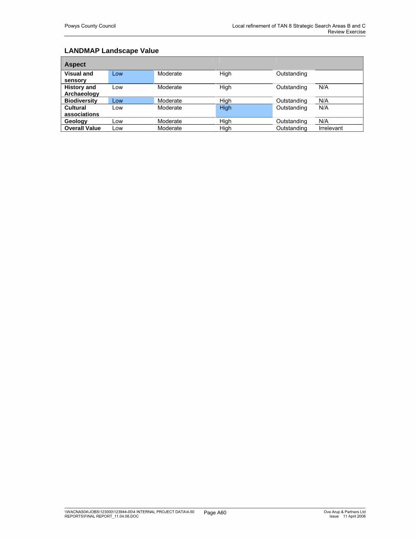
Powys County Council Local refinement of TAN 8 Strategic Search Areas B and CReview Exercise
\\WACNAS04\JOBS\123000\123944-00\4 INTERNAL PROJECT DATA\4-50 REPORTS\FINAL REPORT_11.04.08.DOC
Page A60 Ove Arup & Partners LtdIssue 11 April 2008
LANDMAP Landscape Value
Aspect
Visual and sensory
Low Moderate High Outstanding
History and Archaeology
Low Moderate High Outstanding N/A
Biodiversity Low Moderate High Outstanding N/A Cultural associations
Low Moderate High Outstanding N/A
Geology Low Moderate High Outstanding N/A Overall Value Low Moderate High Outstanding Irrelevant

Powys County Council Local refinement of TAN 8 Strategic Search Areas B and CReview Exercise
\\WACNAS04\JOBS\123000\123944-00\4 INTERNAL PROJECT DATA\4-50 REPORTS\FINAL REPORT_11.04.08.DOC
Page A61 Ove Arup & Partners LtdIssue 11 April 2008
POWYS WINDFARMS SSA C: Landscape sensitivity worksheet
AREA: C10 BANC DU
Generally criteria from better to worse for large scale windfarms, left to right.
Visual and Sensory
Criteria from LANDMAP assessment
PHYSICAL Topographic form
plateau rolling/undulating hills/valleys levels Mountains high hills
Landcover pattern
forestry open land field pattern/mosaic
development
Settlement pattern
no settlements
scattered/rural/farm clustered urban
AESTHETIC Scale of landform
vast Large medium small intimate
Scale of landcover
vast Large medium small intimate
Sense of enclosure
confined Enclosed open exposed
Diversity uniform Simple diverse complex PERCEPTUAL Level of
human access
rare Occasional infrequent frequent constant
Presence of attractive views
None Some Many
Presence of detractive views
Many Some None
Tranquillity Noisy Tranquil Remoteness Remote Settled Wildness Human
intervention Wild
Other criteria
Skyline smooth rounded complex
Skyline/ridge multiple single
Sensitive features
no sensitive features
some sensitive features
features on skyline
Vertical elements
Many Masts and pylons
Some masts and pylons
No man made vertical elements
Landscape Character Sensitivity Summary Overall sensitivity
Low Medium-low Medium Medium-high High
Comments This is an area of undulating hills and saddles extending the plateau to the north and interspersed with an incised valley. The landcover is predominantly upland grassland with some scattered blocks of small conifer plantation. The area is remote, tranquil and wild with no settlement. Fowler’s Armchair stone circle [SAM] lies in the centre of the area and is of medium high sensitivity and requires careful consideration by any windfarm development. The rest of the area is medium low sensitivity. The P and L windfarm is visible to the north. Wide views are possible from the high points including to the forestry and lower settled land to the south.

Powys County Council Local refinement of TAN 8 Strategic Search Areas B and CReview Exercise
\\WACNAS04\JOBS\123000\123944-00\4 INTERNAL PROJECT DATA\4-50 REPORTS\FINAL REPORT_11.04.08.DOC
Page A62 Ove Arup & Partners LtdIssue 11 April 2008
LANDMAP Landscape Value
Aspect
Visual and sensory
Low Moderate High Outstanding
Historic landscape
Low Moderate High Outstanding N/A
Biodiversity Low Moderate High Outstanding N/A Cultural associations
Low Moderate High Outstanding N/A
Geology Low Moderate High Outstanding N/A Overall Value Low Moderate High Outstanding Irrelevant

Powys County Council Local refinement of TAN 8 Strategic Search Areas B and CReview Exercise
\\WACNAS04\JOBS\123000\123944-00\4 INTERNAL PROJECT DATA\4-50 REPORTS\FINAL REPORT_11.04.08.DOC
Page A63 Ove Arup & Partners LtdIssue 11 April 2008
POWYS WINDFARMS SSA C: Landscape sensitivity worksheet
AREA: C11 WARN DDUBARTHOG WINDFARM
Generally criteria from better to worse for large scale windfarms, left to right.
Visual and Sensory
Criteria from LANDMAP assessment
PHYSICAL Topographic form
plateau rolling/undulating hills/valleys levels mountains
Landcover pattern
forestry open land field pattern/mosaic
development
Settlement pattern
no settlements
scattered/rural/farm clustered urban
AESTHETIC Scale of landform
vast Large medium small intimate
Scale of landcover
vast Large medium small intimate
Sense of enclosure
confined Enclosed open exposed
Diversity uniform Simple diverse complex PERCEPTUAL Level of
human access
Rare [LANDMAP]
occasional infrequent frequent constant
Presence of attractive views
None Some out over lower areas
Many
Presence of detractive views
Many Some [of construction associated with wind farm]
None
Tranquillity Noisy Tranquil [LANDMAP]
Remoteness Remote Settled Wildness Human
intervention Wild
Other criteria
Skyline smooth rounded complex
Skyline/ridge multiple single
Sensitive features
no sensitive features
some sensitive features
features on skyline
Vertical elements
Many Masts and pylons
Some masts and pylons
No man made vertical elements

Powys County Council Local refinement of TAN 8 Strategic Search Areas B and CReview Exercise
\\WACNAS04\JOBS\123000\123944-00\4 INTERNAL PROJECT DATA\4-50 REPORTS\FINAL REPORT_11.04.08.DOC
Page A64 Ove Arup & Partners LtdIssue 11 April 2008
Landscape Character Sensitivity Summary Overall sensitivity Low Medium-low Medium Medium-high High Comments This is an area of smooth profile upland grazing with conifer blocks disrupting the skyline. The bulk of the area is east facing dip slope with the exception of the north western parts which form part of the scarp slope facing north and west. The existing P and L windfarm is located in the area. The area is remote with settlement limited to a farm on its eastern edge. Wide views are possible from the high points including the lower settled land to the east. The landscape sensitivity of the area to a large scale windfarm is considered to be low on the main part of the dip slope. The area to the north west is considered to be medium-high on and adjacent to the scarp slopes.
LANDMAP Landscape Value
Aspect
Visual and sensory
Low Moderate High Outstanding
History and Archaeology
Low Moderate High Outstanding N/A
Biodiversity Low Moderate High Outstanding N/A Cultural associations
Low Moderate High Outstanding N/A
Geology Low Moderate High Outstanding N/A Overall Value Low Moderate High Outstanding Irrelevant
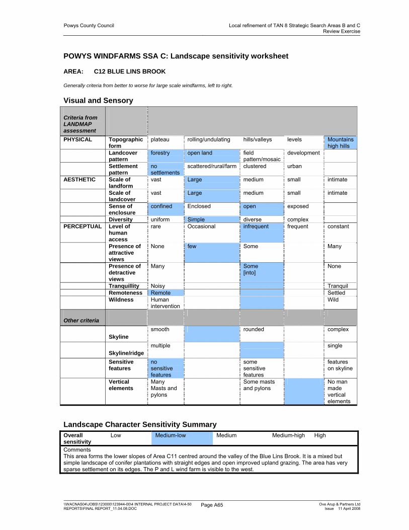
Powys County Council Local refinement of TAN 8 Strategic Search Areas B and CReview Exercise
\\WACNAS04\JOBS\123000\123944-00\4 INTERNAL PROJECT DATA\4-50 REPORTS\FINAL REPORT_11.04.08.DOC
Page A65 Ove Arup & Partners LtdIssue 11 April 2008
POWYS WINDFARMS SSA C: Landscape sensitivity worksheet
AREA: C12 BLUE LINS BROOK
Generally criteria from better to worse for large scale windfarms, left to right.
Visual and Sensory
Criteria from LANDMAP assessment
PHYSICAL Topographic form
plateau rolling/undulating hills/valleys levels Mountains high hills
Landcover pattern
forestry open land field pattern/mosaic
development
Settlement pattern
no settlements
scattered/rural/farm clustered urban
AESTHETIC Scale of landform
vast Large medium small intimate
Scale of landcover
vast Large medium small intimate
Sense of enclosure
confined Enclosed open exposed
Diversity uniform Simple diverse complex PERCEPTUAL Level of
human access
rare Occasional infrequent frequent constant
Presence of attractive views
None few Some Many
Presence of detractive views
Many Some [into]
None
Tranquillity Noisy Tranquil Remoteness Remote Settled Wildness Human
intervention Wild
Other criteria
Skyline smooth rounded complex
Skyline/ridge multiple single
Sensitive features
no sensitive features
some sensitive features
features on skyline
Vertical elements
Many Masts and pylons
Some masts and pylons
No man made vertical elements
Landscape Character Sensitivity Summary Overall sensitivity
Low Medium-low Medium Medium-high High
Comments This area forms the lower slopes of Area C11 centred around the valley of the Blue Lins Brook. It is a mixed but simple landscape of conifer plantations with straight edges and open improved upland grazing. The area has very sparse settlement on its edges. The P and L wind farm is visible to the west.

Powys County Council Local refinement of TAN 8 Strategic Search Areas B and CReview Exercise
\\WACNAS04\JOBS\123000\123944-00\4 INTERNAL PROJECT DATA\4-50 REPORTS\FINAL REPORT_11.04.08.DOC
Page A66 Ove Arup & Partners LtdIssue 11 April 2008
LANDMAP Landscape Value
Aspect
Visual and sensory
Low Moderate High Outstanding
History and Archaeology
Low Moderate High Outstanding N/A
Biodiversity Low Moderate High Outstanding N/A Cultural associations
Low Moderate High Outstanding N/A
Geology Low Moderate High Outstanding N/A Overall Value Low Moderate High Outstanding Irrelevant
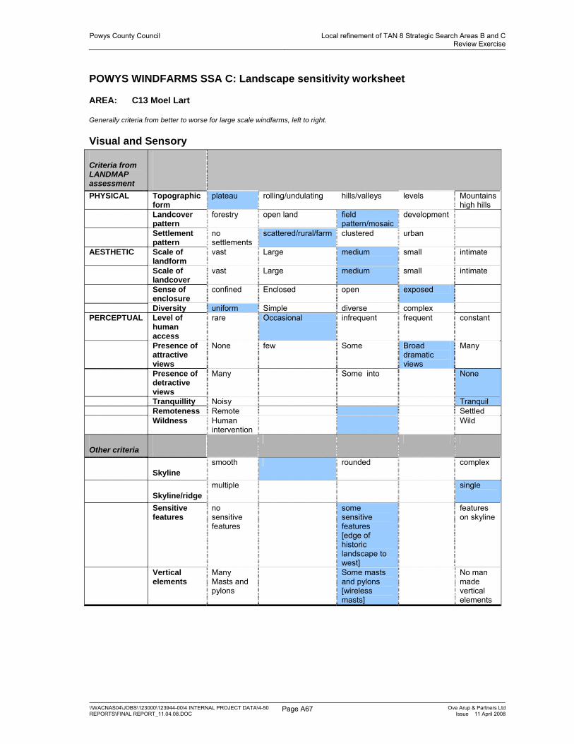
Powys County Council Local refinement of TAN 8 Strategic Search Areas B and CReview Exercise
\\WACNAS04\JOBS\123000\123944-00\4 INTERNAL PROJECT DATA\4-50 REPORTS\FINAL REPORT_11.04.08.DOC
Page A67 Ove Arup & Partners LtdIssue 11 April 2008
POWYS WINDFARMS SSA C: Landscape sensitivity worksheet
AREA: C13 Moel Lart
Generally criteria from better to worse for large scale windfarms, left to right.
Visual and Sensory
Criteria from LANDMAP assessment
PHYSICAL Topographic form
plateau rolling/undulating hills/valleys levels Mountains high hills
Landcover pattern
forestry open land field pattern/mosaic
development
Settlement pattern
no settlements
scattered/rural/farm clustered urban
AESTHETIC Scale of landform
vast Large medium small intimate
Scale of landcover
vast Large medium small intimate
Sense of enclosure
confined Enclosed open exposed
Diversity uniform Simple diverse complex PERCEPTUAL Level of
human access
rare Occasional infrequent frequent constant
Presence of attractive views
None few Some Broad dramatic views
Many
Presence of detractive views
Many Some into None
Tranquillity Noisy Tranquil Remoteness Remote Settled Wildness Human
intervention Wild
Other criteria
Skyline smooth rounded complex
Skyline/ridge multiple single
Sensitive features
no sensitive features
some sensitive features [edge of historic landscape to west]
features on skyline
Vertical elements
Many Masts and pylons
Some masts and pylons [wireless masts]
No man made vertical elements

Powys County Council Local refinement of TAN 8 Strategic Search Areas B and CReview Exercise
\\WACNAS04\JOBS\123000\123944-00\4 INTERNAL PROJECT DATA\4-50 REPORTS\FINAL REPORT_11.04.08.DOC
Page A68 Ove Arup & Partners LtdIssue 11 April 2008
Landscape Character Sensitivity Summary Overall sensitivity
Low Medium-low Medium Medium-high High
Comments This is an upland ridge 300m above the surrounding valleys with undulating skyline forming the northern extent of the upland area on which the P and L windfarm stands. Settled valleys lie on either side, the Severn to the west. Landcover is unenclosed upland grazing grassland on the tops with some discontinuous hedgerows at lower levels. A wireless mast stands on the highest point. Wide views are possible north, west and east.
LANDMAP Landscape Value
Aspect
Visual and sensory
Low Moderate High Outstanding
History and Archaeology
Low Moderate High Outstanding N/A
Biodiversity Low Moderate High Outstanding N/A Cultural associations
Low Moderate High Outstanding N/A
Geology Low Moderate High Outstanding N/A Overall Value Low Moderate High Outstanding Irrelevant

Powys County Council Local refinement of TAN 8 Strategic Search Areas B and CReview Exercise
\\WACNAS04\JOBS\123000\123944-00\4 INTERNAL PROJECT DATA\4-50 REPORTS\FINAL REPORT_11.04.08.DOC
Page A69 Ove Arup & Partners LtdIssue 11 April 2008
POWYS WINDFARMS SSA C: Landscape sensitivity worksheet
AREA: C14 KERRY RIDGEWAY WOODLAND
Generally criteria from better to worse for large scale windfarms, left to right.
Visual and Sensory
Criteria from LANDMAP assessment
PHYSICAL Topographic form
plateau rolling/undulating hills/valleys levels Mountains
Landcover pattern
forestry open land field pattern/mosaic
development
Settlement pattern
no settlements
scattered/rural/farm clustered urban
AESTHETIC Scale of landform
vast Large medium small intimate
Scale of landcover
vast Large medium small intimate
Sense of enclosure
confined Enclosed open exposed
Diversity Uniform [LANDMAP]
Simple diverse complex
PERCEPTUAL Level of human access
rare Occasional infrequent frequent constant
Presence of attractive views
None Some [out to lowland]
Many
Presence of detractive views
Many Some [within forestry]
None
Tranquillity Noisy Tranquil Remoteness Remote Settled Wildness Human
intervention Wild
Other criteria
Skyline smooth rounded complex
Skyline/ridge multiple single
Sensitive features
no sensitive features
some sensitive features [stone circles and tumuli]
features on skyline
Vertical elements
Many Masts and pylons
Some masts and pylons
No man made vertical elements

Powys County Council Local refinement of TAN 8 Strategic Search Areas B and CReview Exercise
\\WACNAS04\JOBS\123000\123944-00\4 INTERNAL PROJECT DATA\4-50 REPORTS\FINAL REPORT_11.04.08.DOC
Page A70 Ove Arup & Partners LtdIssue 11 April 2008
Landscape Character Sensitivity Summary Overall sensitivity
Low Medium-low Medium Medium-high High
Comments This area forms the continuation of the Kerry Ridgeway area [Areas C1 and C2] as an upland ridge. The dominant landcover is forest plantations with large blocks of open improved grazing between. The landcover is therefore simple. There are some historic features such as tumuli in this area. The Kerry Ridgeway path itself runs through the area and there is a picnic site on the trail and limited farming settlement to the east.
LANDMAP Landscape Value
Aspect
Visual and sensory
Low Moderate High Outstanding
History and Archaeology
Low Moderate High Outstanding N/A
Biodiversity Low Moderate High Outstanding N/A Cultural associations
Low Moderate High Outstanding N/A
Geology Low Moderate High Outstanding N/A Overall Value Low Moderate High Outstanding Irrelevant
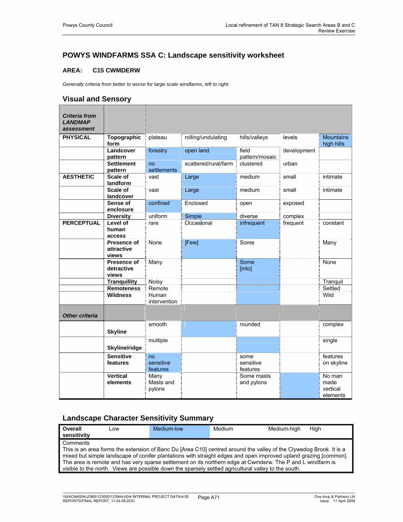
Powys County Council Local refinement of TAN 8 Strategic Search Areas B and CReview Exercise
\\WACNAS04\JOBS\123000\123944-00\4 INTERNAL PROJECT DATA\4-50 REPORTS\FINAL REPORT_11.04.08.DOC
Page A71 Ove Arup & Partners LtdIssue 11 April 2008
POWYS WINDFARMS SSA C: Landscape sensitivity worksheet
AREA: C15 CWMDERW
Generally criteria from better to worse for large scale windfarms, left to right.
Visual and Sensory
Criteria from LANDMAP assessment
PHYSICAL Topographic form
plateau rolling/undulating hills/valleys levels Mountains high hills
Landcover pattern
forestry open land field pattern/mosaic
development
Settlement pattern
no settlements
scattered/rural/farm clustered urban
AESTHETIC Scale of landform
vast Large medium small intimate
Scale of landcover
vast Large medium small intimate
Sense of enclosure
confined Enclosed open exposed
Diversity uniform Simple diverse complex PERCEPTUAL Level of
human access
rare Occasional infrequent frequent constant
Presence of attractive views
None [Few] Some Many
Presence of detractive views
Many Some [into]
None
Tranquillity Noisy Tranquil Remoteness Remote Settled Wildness Human
intervention Wild
Other criteria
Skyline smooth rounded complex
Skyline/ridge multiple single
Sensitive features
no sensitive features
some sensitive features
features on skyline
Vertical elements
Many Masts and pylons
Some masts and pylons
No man made vertical elements
Landscape Character Sensitivity Summary Overall sensitivity
Low Medium-low Medium Medium-high High
Comments This is an area forms the extension of Banc Du [Area C10] centred around the valley of the Clywedog Brook. It is a mixed but simple landscape of conifer plantations with straight edges and open improved upland grazing [common]. The area is remote and has very sparse settlement on its northern edge at Cwmderw. The P and L windfarm is visible to the north. Views are possible down the sparsely settled agricultural valley to the south.

Powys County Council Local refinement of TAN 8 Strategic Search Areas B and CReview Exercise
\\WACNAS04\JOBS\123000\123944-00\4 INTERNAL PROJECT DATA\4-50 REPORTS\FINAL REPORT_11.04.08.DOC
Page A72 Ove Arup & Partners LtdIssue 11 April 2008
LANDMAP Landscape Value
Aspect
Visual and sensory
Low Moderate High Outstanding
History and Archaeology
Low Moderate High Outstanding N/A
Biodiversity Low Moderate High Outstanding N/A Cultural associations
Low Moderate High Outstanding N/A
Geology Low Moderate High Outstanding N/A Overall Value Low Moderate High Outstanding Irrelevant