Local government in Perth: nineteenth century ...
23
Local government in Perth: nineteenth century administration for a twenty first century city? Roy Jones, Research and Graduate Studies, Faculty of Humanities, Curtin University of Technology, GPO Box U1987, Perth, WA 6845, Australia. [email protected] Word count: 5097 Running Head: Local Government in Perth Key Words: Metropolitan Perth; local administration; local government boundaries; local government reform
Transcript of Local government in Perth: nineteenth century ...

Local government in Perth: nineteenth century administration for a twenty first
century city?
Roy Jones, Research and Graduate Studies, Faculty of Humanities, Curtin University
of Technology, GPO Box U1987, Perth, WA 6845, Australia. [email protected]
Word count: 5097
Running Head: Local Government in Perth
Key Words: Metropolitan Perth; local administration; local government boundaries;
local government reform

Abstract:
The local government map of metropolitan Perth has remained largely unchanged since the time of Western Australian gold rush at the end of the nineteenth century. It exhibits a highly fragmentary pattern, with thirty local authorities which are, on average, significantly smaller than those in other Australian capital cities. Over the last half century there have been repeated governmental proposals to reform and rationalise this system, but no significant change has been achieved. This paper will consider why so many local authorities were established at the end of the nineteenth century and why there has been so little change since then, even though the city has grown much more than tenfold since that time and radical local government reform has occurred in several other Australian capital cities. It will then discuss some of the social, economic and planning-related implications of this long period of local government boundary inertia during a time of rapid urban growth and change.

Introduction
The local government map of Western Australia is currently under review (Hatch,
2009). This is nothing new for the state in general, or for the Perth Metropolitan area
in particular. The first suggestions for the rationalisation of Perth’s local government
map – the Greater Perth and Greater Fremantle movements - occurred in 1910 (Johns,
1950), very shortly after the creation of a large number of small local government
units in the course of the state’s 1890-1910 gold rush. In the post war period
numerous further proposals for rationalisation (White, 1954; Local Government
Assessment Committee, 1968; Local Government Boundary Commission, 1972;
Royal Commission on Metropolitan Municipal Boundaries, 1974; Local Government
Advisory Board, 2006) were put forward, none of which led to any significant
boundary changes.
This level of local government stability sets both Perth and Western Australia apart
from the remainder of the country (Dollery et al., 2009). For most of the twentieth
century, the numbers of Australian local authorities have been falling and this trend
has accelerated over the last two decades. Nationwide, the number of local councils
fell from 1067 in 1910 to 826 in 1991 and 603 in 2004 (National Office of Local
Government, 2005, Table 3.2). By that date, the number of local authorities in all the
other mainland states except Queensland had been more than halved from their 1910
totals and a similar radical reduction has now taken place there also
(http://apps.dlgsr.qld.gov.au/lgDirectory/PostalList/Default.aspx. Accessed 17/5/09).
By contrast, in Western Australia, the number of councils fell very slightly from 147
to 138 between 1910 and 1991 and then rose to 142 by 2004.
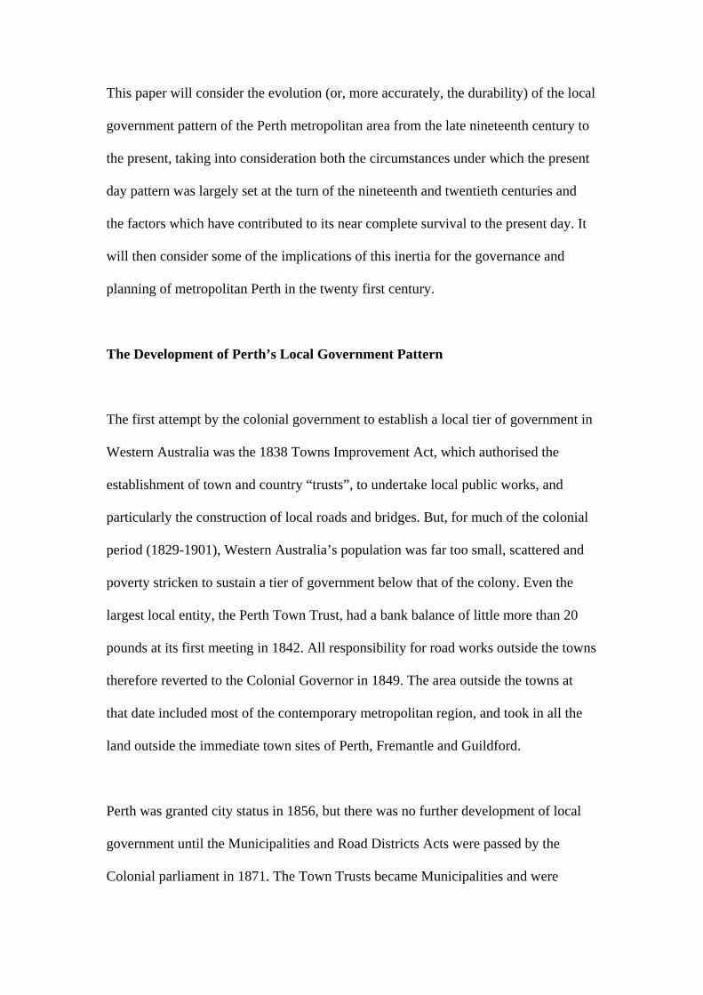
This paper will consider the evolution (or, more accurately, the durability) of the local
government pattern of the Perth metropolitan area from the late nineteenth century to
the present, taking into consideration both the circumstances under which the present
day pattern was largely set at the turn of the nineteenth and twentieth centuries and
the factors which have contributed to its near complete survival to the present day. It
will then consider some of the implications of this inertia for the governance and
planning of metropolitan Perth in the twenty first century.
The Development of Perth’s Local Government Pattern
The first attempt by the colonial government to establish a local tier of government in
Western Australia was the 1838 Towns Improvement Act, which authorised the
establishment of town and country “trusts”, to undertake local public works, and
particularly the construction of local roads and bridges. But, for much of the colonial
period (1829-1901), Western Australia’s population was far too small, scattered and
poverty stricken to sustain a tier of government below that of the colony. Even the
largest local entity, the Perth Town Trust, had a bank balance of little more than 20
pounds at its first meeting in 1842. All responsibility for road works outside the towns
therefore reverted to the Colonial Governor in 1849. The area outside the towns at
that date included most of the contemporary metropolitan region, and took in all the
land outside the immediate town sites of Perth, Fremantle and Guildford.
Perth was granted city status in 1856, but there was no further development of local
government until the Municipalities and Road Districts Acts were passed by the
Colonial parliament in 1871. The Town Trusts became Municipalities and were

required to provide cultural and recreational facilities (parks, libraries etc.) as well as
road maintenance and to levy rates to pay for these services. The Country Trust areas,
now Road Districts, had very small populations. Their responsibilities were still
limited to the maintenance of roads, bridges and drainage works and their finances
came largely from (colonial) government grants. The three isolated town sites of
Perth (a City), Fremantle and Guildford had municipal status, with the bush and
farmland surrounding them being allocated to the Road Districts of Perth, Swan,
Canning and Fremantle to the north west, north east, south east and south west
respectively.
This relatively simple local government pattern remained largely in place until the
gold rush of the 1890s (Berry, 1992). At that point the Perth region’s population
exploded, growing from 20,000 in 1890 to 73,000 in 1900. As new suburbs were
established in the various Road Districts, and particularly along the new railway lines
from Perth to Fremantle, Midland and Armadale (Selwood, 1979) there was “every
incentive to agitate for a separate board for each little centre of development that grew
up” (White, 1954, 7). The main incentive was money. Any “little centre of
development” that became a separate Road Board or Municipality became a lobby
group that could then seek Colonial funds. In 1898, the Municipality of Victoria Park
was receiving over three pounds from the Colony for every pound that it raised in
rates (Government Gazette 18/11/1898, 3386). Around the turn of the nineteenth and
twentieth centuries, therefore, twenty or so small local authorities were established.
These were mainly in what are now the inner suburbs of the Perth metropolitan
region, but new road districts were also established by what were then farming
communities in what is now the outer metropolitan area. This entirely atypical period

of administrative dynamism provided the basis for a local government pattern which,
as Tables 1 and 2 indicate, has essentially survived to the present day.
(Insert Table 1 about here)
The reasons why the local government map of metropolitan Perth has largely
remained fossilised in its turn of the twentieth century configuration - even though the
population of the area has increased to more than 1.6 million and the nature of the city
has been completely transformed - are as mercenary and pragmatic as were those
which produced that early and brief burst of change. Over the course of the twentieth
century, a series of legislative changes have removed the differentials, in terms of
both function and finance, between Municipalities and Road Districts, increased the
powers and responsibilities of local authorities (to include public health, local
planning, social welfare and many other services) and required them to depend on
their own resources - notably rates - for a significant proportion of their revenue
(Jones, 1979). In these circumstances, new suburbs would lose, rather than gain, by
attaining local autonomy during their expensive early years of development.
As Figure 1 and Table 2 indicate, this has produced a somewhat schizophrenic pattern
of small (in area and population) local authorities in the older, inner suburbs and
increasingly larger (certainly in area and frequently in population) local authorities in
the newer, outer suburbs.
(Insert Figure 1 and Table 2 about here)
These anomalies have long been apparent and concerns were soon expressed that
some of the smallest councils lacked both the resources and the skills to carry out

their growing responsibilities. As early as 1910, “Greater Perth” and “Greater
Fremantle” movements sought to incorporate some of the smallest suburban
authorities with their adjoining major centres (Johns, 1950). These initiatives met with
partial success. The largely working class municipalities of North Fremantle, North
Perth, Leederville and Victoria Park were merged with their larger neighbours, while
the relatively more affluent East Fremantle, Subiaco and South Perth remained
independent (Figure 2).
(Insert Figure 2 about here)
Even so, this early twentieth century move towards reform and rationalisation has
been far more successful than have the many more recent attempts. The 1930 Town
Planning Commission Report had noted that a consolidation of the smaller
metropolitan authorities might “ultimately” become necessary. But it was not until
Perth’s growth began to accelerate and the first metropolitan plan (Stephenson and
Hepburn, 1955) was being formulated that proposals for rationalisation began to
appear. White’s (1954) report to the Minister of Local Government was followed by
the Local Government Assessment Committee’s 1968 report, the Local Government
Boundaries Commission’s 1972 report, the 1974 Report of the Royal Commission on
Metropolitan District Boundaries and the 2006 Local Government Advisory Board’s
report. The recommendations of all of these reports were relatively conservative,
certainly in comparison with the relatively recent restructurings of local government
areas that have occurred in other state capitals, such as Melbourne or Adelaide.

But, even in these circumstances, it was, perhaps, unsurprising that the modest
suggestions to amalgamate the small western suburbs councils (Subiaco, Nedlands,
Claremont, Cottesloe, Peppermint Grove and Mosman Park) in various ways, or to
bring about several two council mergers (e.g. Bayswater and Bassendean, Fremantle
and East Fremantle) (see Figure 1) were vehemently and consistently opposed both by
the smaller councils, which saw themselves as being ‘swallowed’ by their larger
neighbours, and by many of their local residents.
The 2009 reform proposals have adopted a rather different approach. In February,
local government minister, John Castrilli, required all of the state’s local authorities
and the Western Australian Local Government Association to provide him with an
“optimal plan” for what were termed ‘voluntary’ council mergers. However, he also
foreshadowed legislation for compulsory amalgamations should the state’s local
authorities prove unable to reach agreement on a sufficiently significant set of
voluntary mergers. In spite of this, recent news reports (Thomson, 2009; Styles,
2009) indicate that, while several rural councils may be “required” to amalgamate,
little or no change is proposed for the Perth Metropolitan area.
Barriers to Change
Webb (1972:32) contended that there were two main reasons why local government
boundary changes in Western Australia were infrequent and conservative:
First, a colonial preference for ad hoc bureaucratic organizations rather than
democratic institutions and secondly the failure of existing local governments,

through petty jealousies and extended ego-trips, to realise the wonderful opportunities
which local government could provide”
In less polemical terms, it is possible to view these as top down (i.e. state government
centric) and bottom up (i.e. local government centric) rationales for the status quo.
The bottom up argument is readily apparent. Smaller local government areas facing
the prospect of amalgamation with their larger neighbours are threatened with a loss
of both identity and employment. Even though the removal of municipal identity and
local employment in a given Perth suburb is unlikely to lead to the loss of, first jobs
and population, and then local services in a downward spiral towards oblivion - as
may be the case for a small country town under threat of losing its local council status
– the fears of job loss for council employees and of diminished access to council
services for local residents remain.
Furthermore, within the Perth metropolitan area, an exceptional and powerful
exemplar of, and thus an argument for, the retention of even the smallest local
government area exists in the form of the Shire of Peppermint Grove. Peppermint
Grove has an area of one square kilometre and a population of well under 2,000 and is
thus by far the smallest metropolitan council in Australia. However, it is also one of
Perth’s most affluent suburbs and thus is home to a disproportionately large number
of highly influential residents. In the 2009 merger debate, it has already been satirised
as “too posh to push” (Cordingley, 2009) because residents currently receive a “valet
wheelie bin service” and might be forced to take their own rubbish and recycling bins
to the kerb should any council merger eventuate. At a more serious level, however, it
has been reported that both the Premier and Local Government Minister were invited

to a meeting of the Peppermint Grove Heritage Society at which major Liberal party
donors and local residents sought and received assurances from them that Peppermint
Grove would be exempt from any mergers that took place (Ranalli, 2009). This story
is supported by Premier Barnett’s own stated merger preferences (Williams, 2009) in
which he advocates amalgamations between significantly larger authorities, such as
Cottesloe and Mosman Park or Claremont and Nedlands, but defends the special
status of Peppermint Grove as “the Monaco of WA”.
Perhaps inevitably, this has led to the Labor opposition deriding the entire merger
initiative (“Merger push is a farce, says Labor”. Cottesloe –Mosman Post 28/3/09, 5)
and even to some residents of another exclusive suburb, Dalkeith, arguing that their
locality could and should be split from the already relatively small City of Nedlands
on the grounds that Dalkeith has twice the population of Peppermint Grove (Thomas,
2009).
Such developments would indicate that bottom up local sentiments are unlikely to be
supportive of any push towards mergers, but Webb also implied that top down support
for them by the state government may be at best lukewarm. This, too, is likely to still
be the case in 2009. Western Australian governments have shown themselves to be
extremely timid when approaching issues on which the electorate has been relatively
evenly divided. In cases such as daylight saving and the deregulation of shopping
hours they have shown a preference for holding referenda, rather than legislating, a
practice which, in Australia, characteristically leads to a no vote and the perpetuation
of the status quo. Of the major local government amalgamation proposals only
White’s (1954) proposals reached state parliament and even these were rejected by the

Legislative Council. Since then, the so-called ‘Dadour amendment’ of the 1970s
requires any proposal for a merger to be put to the electors of all the council areas
concerned and for majorities in favour of any change to be gained in all the affected
council areas. It is unlikely that a majority in favour of change could be obtained in
any area where the council concerned opposed any alteration.
Furthermore, it has been argued, by a former politics professor and state Governor
(Reid, 1969), that there are some political advantages to the state in having a larger
number of smaller councils, since this magnifies the power imbalance between these
two tiers of government and thereby enhances the state’s ability to ‘divide and rule’.
The presence of 30 local authorities in metropolitan Perth may seem like overkill in
this regard. At the very least, however, in a state like Western Australia, where ca.
70% of the state’s population live in the metropolitan area, this would seem to
preclude the superficially logical solution of creating a single local authority for
greater Perth. Such an entity would be so close to the state government in terms of
population size that intergovernmental relations could readily become strained. In
Australia, it is only in Queensland, where the majority of the state’s population lives
outside greater Brisbane, that there is a single metropolitan council of this type.
Finally, even if the state government possessed the inclination, the political will and
the support of sufficient members in both houses of parliament to succeed where all
previous attempts have failed and to force through a systematic redrawing of Perth’s
local government map, this would prove to be what the Local Government Journal of
Western Australia has termed a “mucky business”. The reason for this is the
imprecision of the criteria for drawing such boundaries and the lack of agreement as

to their relative importance. Indeed Soul and Dollery (2000, 2) argue that, in recent
Australian local government amalgamation inquiries, such criteria were not only
“intrinsically incoherent, but that they have generally been inconsistently applied to
the problem of local government amalgamation”.
I have argued elsewhere (Jones, 1979) that the representatives of larger councils will
generally argue for amalgamations using economic criteria, citing efficiency and
economies of scale. However, several authors (e.g. Syme Marmion and Company,
2005: Dollery and Crase, 2004) have queried the extent to which any of the claimed
economies of scale actually eventuate. Conversely smaller councils will tend to
privilege social arguments, arguing for the primacy of a sense of community, even
though in doing so they fly in the face of Cox’s (1976, 208) assertion that:
No term which might have had a useful role to play has been more beaten into
senselessness than “community”. And especially so when what is meant is a small
section of a city.
While these economic and social criteria are used by various stakeholders to dispute
the preferred size of local government units, they do not necessarily provide any
guidance on where the boundaries should be drawn between them. It is here that
Lloyd Jones’ (1972, 3) concern that “the areas of local government are not related to
the areas over which people otherwise live their lives” has relevance. Within any
metropolitan region the areas over which people live their lives are highly diverse and
complex (and may vary considerably even between different members of the same
household). Lloyd Jones’ concern could therefore only be fully addressed by the

creation of a single metropolitan authority which, as has been indicated above, would
be politically unfeasible in the case of the Perth region.
The implications of inertia
It is not surprising that the first flurry of proposals for local government
reorganisation coincided with the development of the first metropolitan-scale
planning schemes, notably the Stephenson-Hepburn Plan (1955), the Perth
Metropolitan Region Scheme (1963) and the Corridor Plan for Perth (Metropolitan
Regional Planning Authority, 1970). The preparation and, still more, the
implementation of such schemes requires cooperation between the state planning
instrumentalities and the metropolitan local authorities. The greater the number of
local authorities (30 in the case of metropolitan Perth), the greater is the challenge of
achieving cooperation, both between the councils and the state government and
amongst the councils themselves, since both the state government and the individual
councils have differing agendas and aspirations (Jones, 2009). In the 1970s and
1980s, for example, the Corridor Plan for Perth sought to develop major outer
suburban service and employment centres on the region’s transport corridors. Such a
strategy had a degree of logic at the metropolitan scale, but provided few benefits, and
possibly even some costs, to the ‘middle ring’ of councils. Several of these authorities
therefore permitted large scale expansions of regional shopping centres to occur.
These both provided competition to and drained investment from the proposed
corridor centres thus compromising the success of the overall metropolitan strategy
(Yiftachel and Kenworthy, 1992).

A very different implication of inertia relates to Dollery et al.’s (2009) contention
that, even though many council amalgamations fail to achieve the efficiencies and
economies of scale that their proponents had hoped for, in many cases the threat of
amalgamation can achieve comparable ends. They argue that “Australian councils are
typically characterised by inertia and a chronic inability to react efficaciously to
changes in the economic and social environment” (Dollery et al., 2009, 277).
Conversely, a change in the political environment in the form of the threat of
amalgamation will oblige councils both to look at and improve their own internal
processes and to seek ways of cooperating more effectively with their neighbours.
Dollery et al. (2009) note such positive behaviour patterns in threatened councils in
rural New South Wales. In metropolitan Perth, however, many amalgamation
proposals have come and gone over the last half century or so to no effect. In these
circumstances it is reasonable to questin whether or not the current process will
indeed produce increased council efficiencies or whether the failure of previous
reform attempts will result in the councils regarding the current process as being little
more than a “crying wolf” problem that will, like all its predecessors, merely go away.
Certainly the Premier’s recent comments on Peppermint Grove as Western Australia’s
Monaco would appear to detract from the seriousness of the current threat as do the
most recent news reports ((Thomson, 2009; Styles, 2009).
A final implication of inertia relates to the demographic trends which have led to the
gentrification of many of Perth’s inner suburbs in recent decades. This has produced
a situation whereby there is an increasingly close correlation between council
population size and socioeconomic status. The small local council areas of the

western suburbs form what has been termed a ‘golden triangle’ of affluent residential
districts between Subiaco, City Beach and Mosman Park. Fremantle has gentrified
rapidly, particularly during and after its staging of the Americas Cup defence in the
1980s. In the 1990s, the large (in demographic terms) City of Perth was divided into
four municipalities, Perth, Cambridge, Victoria Park and Vincent. This latter move
restored local autonomy to several hitherto working class, but now gentrified, inner
suburbs which had been absorbed into a ‘Greater Perth’ almost a century before.
This correlation between council size and socioeconomic status is relevant because it
is the more educated, affluent and articulate members of society who are best able to
organise and to lobby for their sectional interests. As planning processes have become
more consultative, well-organised middle class lobby groups, with their greater
financial, networking and administrative resources and skills have been able to wield
increasing influence over planning decisions. The state government is well aware of
this and, in such consultative exercises as the Dialogue with the City (Hopkins, 2009),
it has deliberately sought to involve the young, people from non English speaking
backgrounds and ‘ordinary’ citizens more generally, albeit with limited success. If,
as is currently the case, the more aware and articulate section of Perth’s population
has both more councils and more councillors per head than do those living in the
remainder of the metropolitan area, this is likely to increase their already
disproportionate influence in this regard.
Conclusion
In his consideration of the political map of Africa, Collier (2009) has argued that the
European imperial powers, in their late nineteenth century ‘scramble’ for that

continent, created a fragmented and incoherent pattern of countries, with boundaries
that bore little reality to the pre-existing tribal geographies. In doing so, he has
contended, the Europeans created a contemporary, post-independence Africa in
which most of its countries are both too large to be nations (i.e. they lack cultural –
usually tribal – unity) but too small to be states (i.e. they lack sufficient human and
economic resources to provide an adequate standard of governance for their
populations).
By contrast, the fragmented and currently incoherent political map of metropolitan
Perth, was created from below, by communities which were seeking either local
autonomy, or a lobbying base or both. However, this map was created in an imperial
context and the driving forces behind the contemporary African and metropolitan
Perth political maps - the scramble for Africa and the Western Australian gold rush
respectively – were both operating at their strongest at roughly the same time.
Certainly it can be argued that these forces have created comparable results in that
most, if not all, of Perth’s local authorities are too large to be communities and – in
spite of the fact that the majority now carry that title – they are all too small to be
cities in the sense that metropolitan Perth is a city.
A century or more ago, when the Perth metropolitan area had a population of 100,000
or less, settlements like Perth and Fremantle were their own ‘cities’ and there was a
considerable amount of open bush and farmland between them. Likewise, a number
of, at least the smaller Road Boards (see Table 1), were both small enough and
isolated enough to have possessed many of the characteristics of a community. In
2009, however, the boundaries of functional City of Perth extend far beyond the

central business district which bears this formal title. Indeed ‘Network City’ (Western
Australian Planning Commission, 2004) and ‘Directions 2031’ (Western Australian
Planning Commission, 2009) , the latest regional plans, see it as encompassing
Mandurah and the remainder of Peel as well as the currently defined metropolitan
region. Equally, few if any of Perth’s local authorities can be said to comprise a
community. Most contain several suburbs and, in the twenty first century metropolis,
communities of interest, which link like-minded individuals across metropolitan
regions and beyond, tend to be more important to city dwellers than are their local
communities of (suburban) place (Rofe, 2009) .
Metropolitan Perth is light years away from the levels of social, political and
economic dysfunctionality that currently afflict many African nations, but its
contemporary local government map is also light years away from the current social,
economic and lived realities of the city’s inhabitants.
References
Berry, C. (1992). The Evolution of Local Planning in Western Australia. In D. Hedgcock and O. Yiftachel (Eds.).Urban and regional planning in Western Australia (pp.17-29). Perth: Paradigm Press. Collier,P. (2009). Wars, guns and votes. London: the Bodley Head. Cordingley, G. (2009). Why Peppy Grove is too posh to push. The Sunday Times 22/2/09 (p.5). Cox W. (1976). Cities: the public dimension. Harmondsworth: Penguin. Dollery, B. and Crase, L. (2004). Is bigger local government better? An evaluation of the case for Australian municipal Amalgamation programs. Urban Policy and Research, 22 (3), 265-276. Dollery, B., Crase, L. and O’Keefe, S. (2009) Improving efficiency in Australian local government; Structural reform as a catalyst for effective reform. Geographical Research, 47 (3), 269-279.
Hatch, D. (2009). Small councils forced to merge. The West Australian, 6/2/09, (p.1). Hopkins, D. (2009). Planning metropolitan Perth through dialogue: participatory democracy or manufactured consent? In I. Alexander, D. Hedgcock and S. Grieve (Eds.) Urban and regional development in Western Australia: progress in planning? Fremantle: Fremantle Press. (in press) Johns, J. (1950). Metropolitan government in Western Australia. Department of Economics Publication Series B (Public Administration) No. 1. University of Western Australia. Jones, R. (1979). Local and metropolitan government. In Gentilli, J. (Ed.) Western landscapes, (pp.483-498). Nedlands, WA: University of Western Australia Press. Jones, R. (2009). Local government in and metropolitan planning for Perth: A catchweight contest or a prize fight? In I. Alexander, D. Hedgcock and S. Grieve (Eds.) Urban and regional development in Western Australia: progress in planning? Fremantle: Fremantle Press. (in press) Lloyd-Jones, S. (1972). Contribution to the Second National Seminar, Institute of Municipal Administration. Canberra. Local Government Advisory Board (2006). Local government structural and electoral reform in Western Australia: Ensuring the future sustainability of communities. Perth: Local Government Advisory Board. Local Government Assessment Committee (1968). Report on aspects of local government in Western Australia 1968. Perth: Government Printer. Local Government Boundaries Commission (1972). Report on metropolitan municipal boundaries 1972. Perth: Government Printer. Metropolitan Regional Planning Authority (1970). The corridor plan for Perth. Perth: Metropolitan Regional Planning Authority. National Office of Local Government (2005). Local government national report. Canberra: Commonwealth Department of Transport and Regional Services. Ranalli, R. (2009). ‘Monaco’ is safe. Mosman Cottesloe Post, 21/3/09, p.1 Reid, G. (1969). Why local government? Supplementary Paper 1. In Australian Frontier Consultation Report The future of local government in the Perth metropolitan region. Bentley, WA: WAIT, 7-16. Rofe, M. (2009). Globalisation, gentrification and spatial hierarchies in and beyond New South Wales: the local/global nexus. Geographical Research, 47(3), 292-305.

Royal Commission on Metropolitan District Boundaries (1974). Royal commission on metropolitan district boundaries. Perth: Government Printer. Selwood, J. (1979). Public transport and urban growth. In Gentilli, J. (Ed.)Western landscapes, (pp. 423-444). Nedlands, WA: University of Western Australia Press. Soul, S. and Dollery, B. (2000). An analysis of the criteria used by Australian local government amalgamation inquiries between 1960 and 1992. University of New England, School of Economic Studies, Working Paper Series in Economics, 2000-9. Stephenson, G. and Hepburn, J. (1955). Plan for the metropolitan region, Perth and Fremantle. Perth: Government Printer. Styles, A. (2009). Castrilli denies councils will be razored. http://watoday.com.au Accessed 6/10/2009. Syme Marmion and Company (2005). Structural reform review prepared for the City of Geraldton and the Shires of Greenough, Chapman Valley, Irwin and Mullewa. Perth: Syme Marmion and Company. Thomas, B. (2009). Dalkeith move to break away from Nedlands. The West Australian, 20/5/09, (p.3). Thomson, C. (2009). Local government wipeout; Castrilli to cull one-third of councils http://watoday.com.au Accessed 6/10/2009. Webb, M. (1972). Lets abandon fractured communities for three tiers of local government. Local Government Journal of Western Australia 38 (1), 30-53. Western Australian Planning Commission, 2004. Network city: community planning strategy for Perth and Peel. Perth: Western Australian Planning Commission. Western Australian Planning Commission, 2009. Directions 2031: draft spatial framework for Perth and Peel. Perth: Western Australina Planing Commission. White, A. (1954). The boundaries of metropolitan local authorities. Report to the Hon. Minister for Local Government. Perth: Government Printer. Williams, G. (2009). Barnett’s merger. Cottesloe Mosman Post, 21/3/09, p.1. Yiftachel, O. and Kenworthy, J. 1992. Theoretical perspectives on Perth’s changing urban form. In D. Hedgcock and O. Yiftachel (Eds.), Urban and regional planning in Western Australia, (pp.131-148). Perth: Paradigm Press.

Table 1 Population of Perth Metropolitan Local Government Areas 1900 City Perth 27,553 Municipalities Claremont 2,014 Fremantle 14,708 Fremantle, East 2,494 Fremantle, North 3,246 Guildford 1,459 Helena Vale 1,568
Leederville 2,546 Subiaco 3,004 Victoria Park 1,267
Road Districts Bayswater 900 Belmont 600 Buckland Hill 1,500 (1902) Canning 850 Cottesloe 1,274 Claremont 500 Darling Range 1,400 Jandakot 170 Kelmscott 530 (1903) Peppermint Grove 532 Perth 410 (1903)
Perth, South 947 (1903) Perth, North 1,000 Rockingham 250 Swan 5,000
Source: Statistical Register of Western Australia, 1900 ff.

Table 2 Population of Perth Metropolitan Local Government Areas 2007 Cities Armadale 53,445 Bayswater 59,100 Belmont 32,542
Canning 83,006 Cockburn 80,921 Fremantle 26,777 Gosnells 97,408 Joondalup 157,203 Melville 99,713 Nedlands 21,852 Perth 13,486 Rockingham 91,702 South Perth 41,572 Stirling 189,083 Subiaco 17,835 Swan 100,593 Wanneroo 124,887
Towns Bassendean 14,218 Cambridge 25,400 Claremont 9,535
Cottesloe 7,888 East Fremantle 7079 Kwinana 25,109 Mosman Park 8.894 Victoria Park 30,149 Vincent 30,117
Shires Kalamunda 52,360 Mundaring 37,039 Peppermint Grove 1,662 Serpentine-Jarrahdale 14,194 Source: ABS 3218.0 – Regional Population Growth, Australia, 2006-07. Accessed 27/08/2008. Figure 1 Local government areas 2008 Figure 2 Greater Perth and Greater Fremantle proposals 1910