LM Report Final V2.0 5-11-2011 JS CTH
22
Information Technology Solutions to African Food Security Opportunity Report to: Lockheed Martin Prepared by: CASE Team Carl Hammerdorfer James Schmitt Kathryn Ernst Getinet Nega
-
Upload
james-schmitt -
Category
Documents
-
view
42 -
download
0
Transcript of LM Report Final V2.0 5-11-2011 JS CTH

Information Technology Solutions to African Food Security
Opportunity Report to:
Lockheed Martin
Prepared by:
CASE Team
Carl Hammerdorfer
James Schmitt
Kathryn Ernst
Getinet Nega

CASE Center for the Advancement of Sustainable Enterprise 2 | P a g e
Forward
This project began with several intriguing and important questions about the use of GPS and
other technologies in the context of sustainable development, and their applicability towards solving
problems with food security in the developing world. The location for this study is Ethiopia, which we
chose for several reasons, including logistics, market, application, network, and potential impact. The
scope of work was defined to seek scalable applications for GPS and other technologies in eight specific,
interrelated areas. The following report is derived from relevant primary and secondary data collection,
personal interviews, group discussions, and multiple strategic discussions amongst Colorado State
University professors and staff. This data collection took place over a two and a half month period in
and around Addis Ababa and Limmu, Ethiopia from January to March 2011.
We would like to thank Duane Grove and Mike Shaw from Lockheed Martin, Dr. Bill Farland
from Colorado State University and Hussen Ahmed from Farm Organic International for their efforts,
inspiration, and financial support allowing this important study to take place.
Eight Proposed Areas of Applicability of Technology Solutions in Ethiopia Climate Change Adaptation
Agricultural Input Use (fertilizer, seeds, soil amendment, moisture)
Early Warning Famine Detection – Crop growth rates
Micro-insurance and Risk Reduction Strategies for at-risk populations
Pastoralists and Land Management
Environmental Conservation and Forest Management
Disaster Detection and Response
Food Security

CASE Center for the Advancement of Sustainable Enterprise 3 | P a g e
Contents Forward ..................................................................................................................................................... 2
Eight Proposed Areas of Applicability of Technology Solutions in Ethiopia ............................................. 2
Introduction: Relevance of technology in the context of food security ....................................................... 4
Overview – Ethiopia ...................................................................................................................................... 4
Stakeholder Environment ............................................................................................................................. 6
Examples of current uses: ......................................................................................................................... 6
United Nations ...................................................................................................................................... 6
Ethiopian Government MOARD ............................................................................................................ 7
World Food Program ............................................................................................................................. 7
WFP Case Study Exemplifying Limitations to Current Uses .......................................................................... 9
Methodology ................................................................................................................................................. 9
Individual Results Matrices ................................................................................................................... 9
Data Collection Methodology ............................................................................................................. 10
Opportunities .............................................................................................................................................. 10
Data Platform - 4.4 .................................................................................................................................. 10
Remote Sensing (water, crops, soil moisture) -3.7 ................................................................................. 12
Adaptation of Precision Agriculture for small holder farmers – 3.7 ....................................................... 12
Climate Change Monitoring /Forest Carbon Sequestering Inventory -2.6 ............................................. 13
From an Interview with Josef Assefa, Professor and Senior Research Instructor from Addis Ababa
University ............................................................................................................................................ 13
Population Detection -2.6 (Infrared) ...................................................................................................... 13
Vehicle Tracking – 2.6 ............................................................................................................................. 14
Integration with Radio Frequency Identification (RFID) tags for inventory tracking 2.6 (WFP foodstuffs
– port to plate) ........................................................................................................................................ 14
Disaster Relief – 2.6 ................................................................................................................................ 14
Conclusion and Next Steps.......................................................................................................................... 15
Appendix ..................................................................................................................................................... 16
2.0 Cambridge Design ................................................................................................................................. 17
3.0 List of Attendees for the Multi Stakeholder Meeting Held March 18th at Damu Hotel, Addis Ababa
Ethiopia ....................................................................................................................................................... 18
4.0 Budget Review ...................................................................................................................................... 19
Bibliography ................................................................................................................................................ 22

CASE Center for the Advancement of Sustainable Enterprise 4 | P a g e
Introduction: Relevance of technology in the context of food security
In 1984, the world watched as millions of Ethiopians starved during a widespread and lengthy
famine brought on by drought, disease, and unsustainable agricultural practices1. The images of
emaciated, starving mothers and babies are indelibly stamped on anyone who witnessed this tragedy on
their television and on the collective consciousness of the global development community. The famine
placed food security front and center in global security and development discussions as Ethiopia
struggled to feed its citizens. Emergency food aid supplied by international relief organizations
eventually served as a band aid to the crisis, but a long-term solution was nowhere in sight. When
famine again threatened Ethiopia in 2000, many organizations began to apply improved technological
solutions, such as GIS and GPS, towards predicting future famine crises.
In 2004 the United Nations Development Program and the Ethiopian Agency for the Ministry of
Finance and Economic Development identified a need to create a common database through which they
could share crucial data. They recognized that only by integrating the disparate datasets organizations
collected individually could they create truly valuable information. The aggregated information,
analyzed by the technology platform, could be used to promote food security, drought response,
sustainable crop cultivation, and natural resources management.
However, since those initial efforts in 2004 to define the need, (a mechanism which integrates
datasets and enables improved decision making), little has been accomplished to advance the use of
GIS/GPS technology across Africa. Individual organizations continue to gather data individually, and
utilize it in their specific functions. There has still been no successful effort to advance the common
platform necessary to take full advantage of the power of GIS/GPS and other technologies in this field.
The Center for Advancement of Sustainable Enterprise and other key researchers at CSU and in
Ethiopia believe that there is an opportunity to expand the application of Lockheed Martin technologies
beyond merely predicting looming crises, and into proactively working to improve the food security of
the nation. Ethiopia can serve as a pilot site for this expanded use of technology solutions to food
security problems, which can then be scaled to have a truly global impact.
Overview – Ethiopia Social
Population of 71,000,000 as of 2004. 85% rural.2
The majority of the population is engaged in subsistence farming: they consume almost all the crops they grow. Because of its degraded lands, poor cultivation practices, and frequent periods of drought, Ethiopia is chronically unable to feed its population and has to rely on massive food imports.
More than 40% of Ethiopians depend on food aid3.
1 http://news.bbc.co.uk/2/hi/africa/703958.stm
2 http://www.mfa.gov.et/Facts_About_Ethiopia/Facts.php

CASE Center for the Advancement of Sustainable Enterprise 5 | P a g e
Environmental
Moderately high altitude and therefore moderate temperature (rarely exceeding 68°F) 4.
Approximately 34 inches average annual rainfall (moderate) 5.
In highlands, rainfall occurs in two distinct seasons: “small rains” (February –March) and “big
rains” (June – September) 6.
Economic
The local currency is the Ethiopian birr7.
Ethiopia's economy is based on agriculture, which accounts for almost half of GDP, 60% of exports, and 80% of total employment. The agricultural sector suffers from frequent drought conditions and poor cultivation practices8.
Ethiopia receives import finance funds from different developing countries to be able to pay for its imported goods9.
Coffee is critical to the Ethiopian economy: exports of $350 million in 2006. Historically low prices have seen many farmers switching to qat (local drug) to supplement income.
Under Ethiopia's constitution, the state owns all land and provides long-term leases to the tenants. This system hampers growth in the industrial sector as entrepreneurs are unable to use land as collateral for loans10.
Ethiopia is a federal democratic republic, but the government owns the land, which is similar to the socialist regime. The government controls everything including capital flows. All the activities supporting exports are welcomed by the government, since it generates foreign currency.
Industry is controlled by the government of Ethiopia. The leading manufactures include processed food, beverages, textiles, leather, chemicals, metal products, and cement. Ethiopia has a poor transportation network11.
Ethiopia prohibits foreign participation in domestic banking, insurance and microcredit services, and several other activities reserved for domestic investors. All foreign investments must be approved and certified by the government.
Telecom
Ethio-Telecom is the sole provider of telecommunications in Ethiopia12.
As of 2009, Ethiopia ranked 200 out of 231 countries in the number of internet hosts available,
as an indicator of connectivity to the internet13.
3 http://www.heritage.org/index/country/Ethiopia
4 http://www.mfa.gov.et/Facts_About_Ethiopia/Facts.php
5 http://www.mfa.gov.et/Facts_About_Ethiopia/Facts.php
6 http://www.mfa.gov.et/Facts_About_Ethiopia/Facts.php
7 http://www.mfa.gov.et/Facts_About_Ethiopia/Facts.php
8 https://www.cia.gov/library/publications/the-world-factbook/geos/et.html
9 http://countrystudies.us/ethiopia/104.htm
10 https://www.cia.gov/library/publications/the-world-factbook/geos/et.html
11 http://www.heritage.org/index/country/Ethiopia
12 https://www.cia.gov/library/publications/the-world-factbook/geos/et.html

CASE Center for the Advancement of Sustainable Enterprise 6 | P a g e
Stakeholder Environment
Since the beginning of the 21st century, there has been an increasing interest globally to apply
GIS and GPS technology to food security issues. This is evidenced by the increasing number of
organizations utilizing the technologies in this field. In fact, in 2004, several groups came together to
promote the idea of creating a common platform. Current stakeholders include national governments,
international aid agencies, and corporations developing GIS/GPS technologies.
Examples of current uses:
United Nations - United Nations Statistics Division (UNSD): “…committed to the advancement of the global
statistical system. We compile and disseminate global statistical information, develop standards and norms for statistical activities, and support countries’ efforts to strengthen their national statistical systems. We facilitate the coordination of international statistical activities and support the functioning of the UN Statistical Commission as the apex entity of the global statistical system.”14
- United National Population Fund (UNFPA): “…an international development agency that
promotes the right of every woman, man and child to enjoy a life of health and equal
opportunity. UNFPA supports countries in using population data for policies and programs to
reduce poverty and to ensure that every pregnancy is wanted, every birth is safe, every young
person is free of HIV, and every girl and woman is treated with dignity and respect.”15
UN Uses of GPS, from article “Integration of GPS, Digital Imagery and GIS with Census Mapping” (Sept
2004) 16
The UNSD uses GPS/GIS for population and
demographics data collection, and are supported by the
UNFPA. However, the organizations have determined a
number of challenges in applying these technologies in
the development context. For example, the commercial
software was cost-prohibitive; there was low availability
of computers, base maps, and satellite imagery; and
organizations in the development sphere already have
full workloads. Therefore, there is interest in developing
the technology to increase utility. There is demand for
cheap units that are increasingly accurate, and GIS
programs that are more user-friendly. There is also demand for the ability to integrate GPS, satellite
imagery, and GIS systems, which adds value to the data collection process.
13
https://www.cia.gov/library/publications/the-world-factbook/rankorder/2184rank.html?countryName=Ethiopia&countryCode=et®ionCode=af&rank=200#et 14
http://unstats.un.org/unsd/default.htm 15
http://www.unfpa.org/public/home/about 16
http://unstats.un.org/unsd/demographic/meetings/egm/CensusEGM04/docs/AC98_14.pdf

CASE Center for the Advancement of Sustainable Enterprise 7 | P a g e
Current and future actions will promote the use of these technologies. For example, the UNSD
provided GIS software (ArcView 3.3) to National Statistic Offices in 40 developing countries. They also
published the “Handbook on Geographic Information System and Digital Mapping” in 2000, to support
the use of these technologies.
Ethiopian Government MOARD
- Ministry of Agriculture and Rural Development (MOARD): tasks include “conservation and
utilization of forest and wildlife resources, food security programme, water harvesting and
small-scale irrigation, monitoring events affecting agricultural development and early warning
system, enhancing market led agricultural development, issue guidelines and procedures for
agricultural input evaluation and release, ensuring the distribution of high quality agricultural
inputs to users, and establishing and directing training centers of agriculture and rural
technology. The New Ministry strives to solve chronic problems associated with: deforestation,
land degradation, lack of land use planning, decline in crop & animal production, dependency on
biomass fuels, and lack of alternatives livelihoods, etc.”17
In 2004, MOARD began training 65,000 agricultural extension agents in a 5-year program, through 25
Agricultural Technique and Vocational Education and Training Colleges located in Ethiopia18. MOARD
acknowledged recently that drought has affected 76 million Ethiopians in the past two decades, and has
enacted broad risk management programs in response19. In 2010, the Disaster Risk Management unit
within MOARD, in conjunction with USAID, produced the Atlas of Ethiopian Livelihoods:
(http://www.feg-consulting.com/what/services/early_warning/livelihood-integration-unit-liu/an-atlas-
of-ethiopia-livelihoods). This 152 page pdf document contains a full analysis and depiction of rural
livelihoods in Ethiopia. This is a great example of the power of integrating diverse data, as this report
combines agricultural, economic, and environmental datasets. It is, however, a one-time, static
document, instead of an on-going effort that can have a more lasting effect.
World Food Program
- World Food Program (WFP): “The World Food Programme is the world's largest humanitarian
agency fighting hunger worldwide. In emergencies, we get food to where it is needed, saving
the lives of victims of war, civil conflict and natural disasters. After the cause of an emergency
has passed, we use food to help communities rebuild their shattered lives. WFP is part of the
United Nations system and is voluntarily funded.”20
17
http://www.unccd.int/cop/reports/africa/national/2004/ethiopia-eng.pdf 18
http://www.ethioembassy.org.uk/news/press%20releases/Moard%20trains%2065,000%20agricultural%20experts.htm 19
http://www.etheja.com/index.php?option=com_content&view=article&id=125:ethiopia-enhances-disaster-management-to-cope-with-climate-impacts&catid=34:environmental-news-cat&Itemid=57 20
http://www.wfp.org/about

CASE Center for the Advancement of Sustainable Enterprise 8 | P a g e
WFP “Drought Risk Management in Ethiopia – the big LEAP” (Dec 2007)
The World Food Program developed a drought insurance program that utilizes software called
LEAP (Livelihoods + Early Assessment + Protection) currently in its second iteration. LEAP addresses the
current problem with timing emergency responses to food crises. If a crisis such as drought happens in
August, a needs assessment might happen in November, and emergency appeal would be made in
January, the story hits the media in March, and life-saving interventions happen May onward. That
means that previously, relief to a disaster such as drought came 8-9 months after the problem occurred.
With the LEAP system, the response time to a food crisis is significantly shortened. If the crisis occurs in
August, the LEAP index will signal the stress as early as September. People in the affected areas can be
enrolled in the drought insurance program in October, and insurance funds will be disbursed mid-
October. This means that in just four months, the response can be initiated, and as early as January,
beneficiaries can be paid cash or food for work.
This represents a huge shift in WFP work, as the LEAP program is designed to actually manage
risks, rather than just respond to crises. Some lessons they have learned since implementing the
program several years ago include:
o There is a market for drought insurance in Ethiopia
o It is possible to create a reliable index, to accurately predict needs.
o Success depends on reliable early warning system (LEAP index), contingency plans,
capacity building, and appropriate funding of contingency plans.
The LEAP software has played a role in enabling the success of WFP responses. Not only can it estimate
the costs associated with salvaging losses from drought, it can also index livelihood losses. This type of
data collection greatly increases the ability to put monetary values on drought disasters. LEAP also
improves the information flow which ensures a quick response – it warns early-on of “livelihood stress
levels” and indicates amount of money needed to protect livelihoods. And in part because of all the
types of data needed to accurately predict stress levels, it also monitors crops and pastures. It does all
of this by integrating a variety of data:
o Crop and soil coefficients (weather data)
o WRSI (Water requirement satisfaction index)
o LPCI (Livelihood Protection Cost index)
In other words, the LEAP program represents a multilateral approach to proactively using technology to
improve people’s lives. It is a long-term project with a variety of stakeholders participating to create a
valuable technology platform that can be utilized by the World Food Program to improve their services.
In addition, LEAP has the potential to be applied to other nations suffering from similar drought
problems. However, although this is a great example of using technology to create solutions to food
security problems, it has some limitations when it comes to scope and utility.

CASE Center for the Advancement of Sustainable Enterprise 9 | P a g e
WFP Case Study Exemplifying Limitations to Current Uses
The World Food Program (WFP) LEAP program described above monitors crops using GPS
technology to measure the growth of the crops, moisture levels, and other information crucial to
maintaining food production, and therefore food security. They have an employee who works on the
ground in Ethiopia collecting this data every day from several selected regions. When they compile the
data into a report, and draw conclusions about potential food shortages, the WFP uses that prediction
to ready their food trucks and drought insurance payouts. By accurately predicting food shortages, WFP
can greatly decrease the response time to a crisis. Shortened response time is considered a success, as
those affected do not starve.
Although the WFP is currently investing human, financial, and technological resources into data
collection, they are limited by their scope of work and area of expertise. They gather critical pieces of
data for their own work, but there are few – if any – other outlets for their data. Despite the fact that
they know ahead of time about agricultural problems, they is no existing mechanism by which the WFP
can share that crucial data with other organizations, such as the Ethiopian Ministry of Agriculture. The
WFP must continue to focus on serving their purpose, but by sharing the data in a standardized format,
combined with data collected by other organizations, the Government of Ethiopia is empowered to
create custom development programs that tackle more problems.
Methodology
Individual Results Matrices
Multiple stakeholders put forward a wide variety of ideas during the course of the study. The
CASE team, in an effort to discern which ideas had the greatest potential for success, developed a basic
matrix and assigned scores related to key criteria that appear valuable to Lockheed Martin. Doubtless
there are internal minimum qualifications that must be met before Lockheed Martin develops a project
and a project partner that provides funds. Given this realization we applied the following basic matrix to
each of the ideas that were put forth.
For Example:
Category Weight Value 0 to 4
Scalable Growth (Market) 90 3
Technical Feasibility 80 4
Financial Opportunity 100 2
Total Possible Weighted Score 270
Total Value Score 9
Total Score Point Average 3.3
We are assuming the weight assigned to each category meets our client’s internal interest levels and
these numbers where selected based on conversations and internet research. This weight was selected
as a way to discern the importance of each category.

CASE Center for the Advancement of Sustainable Enterprise 10 | P a g e
Scalability – Interest spans multiple organizations with multi-national reach. Successful application in
Ethiopia would naturally lead to launch in other countries.
Technical Ability – The opportunity is technically, culturally and professionally feasible.
Financial Opportunity – There are organizations in our study that have the capacity to fund the
development of a system related to all or part of the idea. There is work in the area that is funded by
large donors.
Data Collection Methodology
We gathered data primarily through personal interviews and large multi-stakeholder meetings.
Initially, we distributed a questionnaire, but due to low response stemming from cultural use of email,
telemetry and logistics, we developed a meeting format to facilitate discussion and data collection. In
the end the questionnaire was integrated into a presentation that brought stakeholders together and
collected responses. Please see Appendix 5.0 for individual opportunity scoring detail.
Opportunities
Data Platform - 4.4 In initial interviews with many actors from Government and Civil Society we identified a
significant gap that exists in information sharing and knowledge. In the Department of Agriculture, for
example, interviews with development agents (DA) revealed a lack of tools and resources to effectively
support the large numbers of smallholder farmers. The constraints ranged from a lack of basic
transportation and fuel to enable field visits to the effective lack of any ability to plan and advise
potential irrigation schemes. This situation was confirmed with discussions about DA’s from hiring
authorities and the realization that while the Das had formal education , they often chose to provide
advice based on local traditional practices rather than the latest agricultural technology. This revealed a
lack of coordination and information sharing among universities, regional agricultural centers and the
development agents. Discussions with the Central Statistical Authority (CSA), which is a collection
point for the government’s data, repeatedly revealed and confirmed the lack of resources to collect and
distribute data. This included soil survey results, water availability, input purchasing and/or seed
variety. Furthermore, links to the market enabling improved production were spotty and unreliable at
best.
This lends to an overall revenue system that, while able to collect - at the point of aggregation -
the production data that is so valuable to a DA and therefore food security, lacks the enabling
environment to produce meaningful and actionable outcomes... A system that combines GPS/GIS and
other technology solutions could allow the DA to better utilize scarce transportation resources and offer
better coordinated advice when doing field work. Unless and until this occurs impacts at the farm level
will be insufficient to address food insecurity throughout the country and region. Coordination
challenges among agencies were duly noted in interviews and are supported by secondary research

CASE Center for the Advancement of Sustainable Enterprise 11 | P a g e
(Hoffman, 2011). This is summarized by a weakness identified by the Central Statistics Authority in its
National Strategy for the Development of Statistics: “There is no single focal point for all national
statistics or single database for statistics produced by all ministries” (Authority, 2011).
The Ethiopian Government has acknowledged the need for better statistics in the agricultural
field and has begun participation in a seventeen country program called CountrySTAT, supported by the
Food and Agriculture Organization of the United Nations (FAO) (Nations, 2011). CountySTAT’s mission is
to assist developing counties to develop data sets of information and reporting structures valuable to
the sustainable development and agricultural security of the country. In January of 2011 the CSA held a
conference with FAO CountrySTAT work groups to identify 2twentyof the most important data sets to
focus on. While eighteen sets were identified, few of the datasets were verifiable due to differences at
national and subnational levels, verification challenges, and usability of datasets collected from agencies
outside the CSA. Participation in CountrySTAT has been postponed until these issues can be addressed
(Nations, 2011).
At the local level where government supported cooperatives and unions represent large
numbers of small scale farmers with input and production support, reporting structures are paper
based, resulting in embedded data that is difficult to effectively untangle. For example, the Limmu
Innara Multipurpose Cooperative Union, considered relatively advanced, has difficulty in its
bookkeeping systems. The following photos show a typical fertilizer receipt and accounting book.
This environment opens the door for a larger more coordinated technology solution platform not unlike
a SAP or ERP (see appendix 1.0). Many of the concepts of a supplier management system could be
combined with an appropriate technology device that eases data collection burden and uses GPS as a
pillar. All or some of the 65,000 plus Development Agents could be equipped with such a device and be
the main agricultural data collectors and users, for example.
Recent market institutions like the highly touted Ethiopian Commodity Exchange (ECX) have
begun to extend their reach beyond just coffee. The ECX was formed based on the principles of free and
open markets. Although the institution started with coffee, it is now expanding to include wheat, teff,
sugar and maize. Beyond launching North Africa’s first electronic trading platform the ECX has
extended its reach to the countryside by bringing market price data to the farmer and trader levels. All
of this points to the development of an electronic system that can gather production data, by locality. It
is important to note at this point the need to address differing measurement standards among regions
and the need to tailor a solution to local linguistic needs. (Exchange, 2011).

CASE Center for the Advancement of Sustainable Enterprise 12 | P a g e
Current movement in this area and potential funders include, among others, the Gates Foundation.
Gates in conjunction with the Ethiopian Government has formed the Ethiopian Agricultural
Transformation Agency (EATA) with the intent of increasing production by 14.9% per year over the next
five years (Davidson, 2011). This agreement includes both advice and technical assistance. The Gates
Foundation recently finished a two year study of the Ethiopian DA structure and concluded that training
and capacity are necessary components for significant improvement in food security. The Gates
foundation also supports the CountrySTAT program mentioned above.
Remote Sensing (water, crops, soil moisture) -3.7 Many of the partners interviewed spoke of the need for low cost and accurate meteorological
information. This information is vital for climate change adaptation and mitigation programs,
agricultural management, disaster management, and watershed management. In the area of micro-
insurance programs the ability to have accurate historical rainfall data is vital to the actuarial modeling
necessary for insurance program viability. It is inefficient and unprofitable for insurance carriers that are
considering a new market to rely upon rainfall data from manual or highly embedded historical data.
This plays directly into the need to transfer risk from the smallholder farmer and address food insecure
areas that are highly susceptible to drought.
The National Meteorological Agency of Ethiopia operates weather stations nationwide that
collect data and create regional forecasts. It has regional and local forecasts and provides satellite
imagery directly on its website. But most of this data is collected in disparate databases or manually
accumulated. Reporting of this critical data is cumbersome and in most cases fully manual (Ethiopia N.
M., 2011). Dissemination outside of select government agencies, specified by Ethiopian Law, is costly
and can take up to a month or more before the information flows to the people whose livelihoods and
lives depend upon it. Although the information is available, customers a have found it to be
cumbersome and in the case of the WFP they have chosen to use United States Geological Survey
derived rainfall data for food aid prediction (Mollawork, 2011).
There also exists an opportunity to equip remote wells with water level sensors. This would
enable remote detection of water resources and the eventual development of an aquifer recharge
database. Civil Society efforts to stem famine have indicated a critical need to understand which wells
are depleted and where they are. Current methods involve physical inspection every two weeks, which
in a land burdened by poor, often impassible roadways, becomes expensive and unsustainable. Water
borehole success rates are in the 50% range which places civil society in difficult decision-making
situations when confronted with limited resources (Paralta, 2011). The CASE team and local partners
also discussed the potential to equip camels with GPS equipped tracking collars. Because camels have
an innate ability to locate water, some local actors believe this to be an appropriate technology solution
that capitalizes on animal sensory ability to better locate and tag water resources.
Adaptation of Precision Agriculture for small holder farmers – 3.7 Large scale agriculture uses GPS technology to precisely tie data points to geographic locations.
Input allocation, soil condition, crop production and field boundaries are examples of the types of data
that are useful for a large scale farmer. Interpretation of the data can yield more efficient application of

CASE Center for the Advancement of Sustainable Enterprise 13 | P a g e
fertilizers and localized planting optimization such as seed depth and soil amendment strategies. Data
collection is accomplished with GPS equipped tractors and both manual and remote sensing equipment.
Looking at the technology from a smallholder perspective a host of problems auger against
optimum productivity: There are a multitude of smaller crops in the same area; boundaries are
inconsistent; inputs are scarce, expensive, and poorly applied; all
work is done by hand or using draft animals. Clearly, the
potential for better management exists. Development agents
and extension workers are typically ill-equipped to properly
advise such a diverse cropping group. Thus, common practices
such as irrigation, fertilizer application and seed input
optimization are left to traditional low-yielding methods. An
appropriate technology solution that considers this constrained
environment and yields usable data has the potential to greatly
affect the efficiency of the development agent and the agricultural system as a whole. This would build
local and government capacity, while driving income and productivity growth, and, ultimately, greater
food security among a large and vulnerable population.
While the subject of this study is Ethiopia, this scenario exists throughout Africa, Asia and Latin America.
Climate Change Monitoring /Forest Carbon Sequestering Inventory -2.6
From an Interview with Josef Assefa, Professor and Senior Research Instructor from Addis
Ababa University
Climate change monitoring has potential customers across multiple agencies and institutions
from civil society organizations to private industry. The Ethiopian government has a forward leaning
stance toward carbon offset schemes and has recognized the interconnection between climate change,
deforestation and food security. In many cases civil society, in cooperation with the government, seek
to create projects with cross-cutting benefits (Service, 2011). Fundamental problems relate to the need
for accurate data to satisfy carbon credit certifying agency needs in order to monetize carbon
sequestration. Data that is collected is not standardized in form and tends to be very disparately
distributed and project specific. GPS can play a critical role and is used among many of the
departments within the University. However, the ancillary components that add value, beyond the
typical handheld unit, are not available. Remote sensing and interconnection to data systems as well as
data dissemination are key areas of need.
Population Detection -2.6 (Infrared) – From an interview with Adrian Vanderknapp,
Logistics Director with the World Food Program, February 12, 2011
The WFP struggles with census data that, while recently collected and relatively accurate,
doesn’t work well for a migratory community. With the limited early warning systems currently
employed there is little more than conjecture and historical data to understand populated areas and
respond with food aid. This doesn’t allow for the optimization of distribution points, manifesting or

CASE Center for the Advancement of Sustainable Enterprise 14 | P a g e
warehouses. Adrian mentioned an infrared technology used during the 1994 genocide in Rwanda that
through thermal imaging could accurately detect groups of 500 or more. He felt that if it was possible to
use this data real-time his operation could more easily and efficiently locate population centers, relate
to food shortages, and respond appropriately.
Vehicle Tracking – 2.6 The WFP is currently developing a handheld application based on a PDA that can record
statistics at food delivery points. Their goal is to integrate food truck GPS-based vehicle tracking with a
handheld PDA based application that can input data on beneficiaries. Currently this data is collected by
hand and manually entered. It is time consuming and very difficult to manage with a large fleet. This
data allows WFP to develop a historical picture of areas of common food need and to better plan food
warehouse locations. It allows for more efficient fuel consumption and provides the information
necessary to tell a more accurate picture to the donor community. With paper maps, logistics plans are
developed with imbedded knowledge of the area and estimated needs based on historical data. In
terms of commonly shared data, the WFP knew of no other agencies that share data collected. Most
other agencies have specialized collection equipment and techniques that require costly data re-
engineering for usefulness. This project was being piloted along with a vehicle tracking project in
conjunction with the Ethiopian Government. The system will be trialed in Ethiopia for worldwide WFP
rollout (Wright, 2011).
Integration with Radio Frequency Identification (RFID) tags for inventory
tracking 2.6 (WFP foodstuffs – port to plate) The WFP is also contemplating the use of radio frequency identification tags and related
inventory control equipment to track food delivery. This is envisioned as a port to plate system that can
integrate with indicators such as beneficiary health, population size, and location. It is also vital to
reducing shrinkage associated with food in transport. Lastly the resale of food is a constant problem
and can distort local food production. The ability to better target food aid can reduce this shrinkage
which threatens the free market private sector approach to food security
Disaster Relief – 2.6 The WFP responds to disasters as they happen. Proper data has a direct effect on the quantity
and quality of the aid distributed. The WFP is considering the development of a GPS enabled device that
contains a camera and a vibrometer. Road condition can be automatically discerned by recording the
vibrations generated by road irregularities combined with photo records of damage to trucks. This can
then be used to determine the type and size of vehicle needed to serve an area. Other stakeholders
such as the Ethiopian Government could be users of this data for infrastructure repair. This sort of data
collection and the resulting database has been developed by the University of Cambridge (Daniel Brown,
2010) .
In Cambridge’s’ system (appendix 2.0), on the ground data is collected and combined with
satellite photos, ground surveys, and social audits that are input into a set of indicators. Interpretation
of these indicators is critical to strategy development and disaster response plans. A back end database
is used to record current conditions which are compared to subsequent assessments to judge

CASE Center for the Advancement of Sustainable Enterprise 15 | P a g e
effectiveness. Limitations of this system include satellite imagery cost (25 USD per square kilometer)
and non-application specific data input devices (Daniel Brown, 2010). Host country capacity to run the
system is also a concern and would have to be developed.
There is potential to develop a product or device that can streamline this data collection and
integrate it into a country’s overall data platform. Often, a map of the human terrain is extremely
valuable to government and civil society who are working with limited resources.
Conclusion and Next Steps
In any of the scenarios covered in this analysis more thorough investigation is required to
develop a business case and to strengthen relationships with relevant partners and donors. Integration
into Lockheed Martin’s business planning, project development, technological expertise, and regional
strategies would impact upon the project’s cost and therefore have significant influence on
opportunities and avenues for funding. Clearly, multiple stakeholders are enthusiastic about the
potential to use Lockheed’s technology expertise to impact the stubborn problem of food insecurity. It is
unclear, however, to what extent the larger governmental and NGO sector actors are willing to commit
resources to fund further development of any of the aforementioned solutions. As is typical in the
development community, partners are easy to find, but raising financing is a challenge.
The interest among US government agencies to identify public-private partnership opportunities gives
reason for cautious optimism that further efforts will yield enthusiastic partners and, ultimately, public
funding. USAID and USDA contacts interviewed during this study were quite encouraging. CSU has a
strong record of success managing projects for both of these agencies. We believe that a partnership
with a respected private sector technology partner like Lockheed Martin would be well received by
donors who are frustrated with decades of suboptimal results by the legacy international development
industry. The potential synergies of CSU and LM would, at the very least, cause them to be open to
future, more detailed proposals that build upon this opportunity analysis.
Next Steps
Lockheed Martin evaluates the opportunities outlined in this report, sharing the results
and potential with LM departments that have business or philanthropic interests in food
security interventions.
LM and CSU reconvene to identify the resources that both partners can bring to a more
significant and focused project.
LM and CSU flesh out a working draft of a proposal to launch a project in 2011.
CASE and appropriate LM staff travel to Ethiopia to lock in critical local partners
LM and CSU meet with potential funders to present a draft proposal
CASE provides project management and application of CSU research facilities to a
project that is built upon LM’s technology and solutions expertise.
CASE and LM launch a project –preferably with donor funding, but, if necessary, with
other pilot funding.

CASE Center for the Advancement of Sustainable Enterprise 16 | P a g e
Appendix
1.0 Platform
CASE Center for the Advancement of Sustainable Enterprise 17 | P a g e
2.0 Cambridge Design
CASE Center for the Advancement of Sustainable Enterprise 18 | P a g e
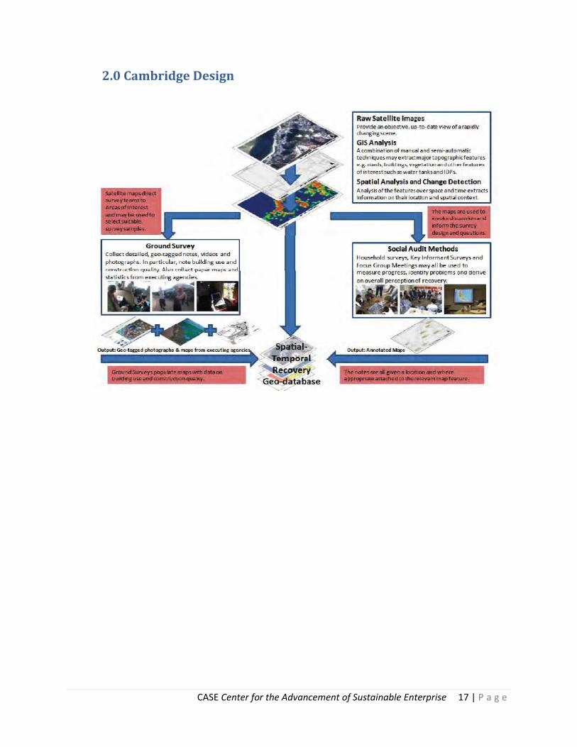
3.0 List of Attendees for the Multi Stakeholder Meeting Held March
18th at Damu Hotel, Addis Ababa Ethiopia
Name Organization E-mail address 1 Araarsa Regassa Oromiya forest & Wild life enterprise [email protected]
2 Rahel Bekele Oxfam GB Senior Program Manager [email protected]
3 Abu Tefera USDA Program Manager [email protected]
4 Kassahun Bedada DRMFSS-EWRD (MoA) Early Warning [email protected]
5 Menghestab Haile WFP Liaison office to the AU & ECA [email protected]
6 Bernard wright WFP GIS Logistics [email protected]
7 Biratie yigezu CSA [email protected]
8 Belay Seyoum WFP GIS Logistics [email protected]
9 Tolu Biressa Ethiopian Space Science Society [email protected]
10 Kiresten Bauman US Embassy USAID [email protected]
11 Samia Zekaira Central Statistical Agency Director [email protected]
12 Gebru Jember CCF-E Climate Change Forum [email protected]
13 Gezahegn Mamusha National Methrological Agency [email protected]
14 Sisay Guta CSA [email protected]
15 Yared Demissie Canuck trading [email protected]
16 Emun Getahun Ministry of Agriculture [email protected]
17 Adefris Teklewold Ethiopian Institute of Agri. Research [email protected]

CASE Center for the Advancement of Sustainable Enterprise 19 | P a g e
4.0 Budget Review
Budget LM Research
Actual LM Research
CASE Expense
unit cost units sub unit cost units sub over
under
Travel 1800 2 3600 2234 1 2234 1366
Manager Stipend (Mgmt Fee, SOW) 2000 5 10000 5000 1 5000 5000
Manager Lodging 600 3 1800 1 1014 786
Per Diem 500 4 2000 45 76 3420 -1420
Translator (Getinet) 100 15 1500 10 79 790 710
Event 450 -450
Misc 97 -97
CASE Director Travel 1800 1 1800 1404 1 1404 396
CASE Director Per Diem 200 5 1000 695 1 695 305
CASE Director Other 500 1 500 1660 1 1660 -1160
0
ICT Center/FOI 2500 4 10000 6810 1 6810 3190
Study/Design/ 1000 1 1000 0 0 0 1000
Ag University 1500 1 1500 0 0 0 1500
SubTotal 34700 0 0 23575 11125
CASE Mgmt Fee 8675 8675 0
TOTAL 43375 32250 11125
Overall Project
Grant Balance - April 23rd $11,125.46

CASE Center for the Advancement of Sustainable Enterprise 20 | P a g e
5.0 Matrix
Data Platform Weight Value 0 to 4
Scalable Growth (Market) 90 4
Technical Feasibility 80 4
Financial Opportunity 100 4
Total Possible Weighted Score
270
Total Value Score 12
Total Score Point Average 4.4
Remote Sensing Weight Value 0 to 4
Scalable Growth (Market) 90 4
Technical Feasibility 80 4
Financial Opportunity 100 2
Total Possible Weighted Score
270
Total Value Score 10
Total Score Point Average 3.7
Precision Agriculture Weight Value 0 to 4
Scalable Growth (Market) 90 4
Technical Feasibility 80 3
Financial Opportunity 100 3
Total Possible Weighted Score
270
Total Value Score 10
Total Score Point Average 3.7
Climate Change Weight Value 0 to 4
Scalable Growth (Market) 90 3
Technical Feasibility 80 2
Financial Opportunity 100 2
Total Possible Weighted Score
270
Total Value Score 7
Total Score Point Average 2.6
Large potential market within the Horn of Africa, Asia, China technically possible with current software, multiple donor interest (Gates, UN, World Bank, USAID)
Large market with infrastructure challenged environments, current technology, low-mid level donor interest
Large potential market within the Horn of Africa, technically possible with current software but needs more R&D, multiple donor interest (Gates, UN, World Bank, USAID)
Medium potential market , technically possible with current software but unknown satellite tech, multiple donor interest (EU, FAO)

CASE Center for the Advancement of Sustainable Enterprise 21 | P a g e
Population Detection Weight Value 0 to 4
Scalable Growth (Market) 90 3
Technical Feasibility 80 2
Financial Opportunity 100 2
Total Possible Weighted Score
270
Total Value Score 7
Total Score Point Average 2.6
Vehicle Tracking Weight Value 0 to 4
Scalable Growth (Market) 90 1
Technical Feasibility 80 4
Financial Opportunity 100 2
Total Possible Weighted Score
270
Total Value Score 7
Total Score Point Average 2.6
Integration with RFID Weight Value 0 to 4
Scalable Growth (Market) 90 1
Technical Feasibility 80 4
Financial Opportunity 100 2
Total Possible Weighted Score
270
Total Value Score 7
Total Score Point Average 2.6
Disaster Relief Weight Value 0 to 4
Scalable Growth (Market) 90 2
Technical Feasibility 80 3
Financial Opportunity 100 2
Total Possible Weighted Score
270
Total Value Score 7
Total Score Point Average 2.6
Limited to specific NGO's, technical unknown and unspecified donor interest
Multiple companies engaged (Blu Tech, Lojack), technology exists, minimal donor potential
Multiple companies currently engaged (SAP), technology exists, minimal donor potential
Current players in the field, medium technology (need appropriate tech development), limited donor appeal (WFP, UNHR)

CASE Center for the Advancement of Sustainable Enterprise 22 | P a g e
Bibliography Index of Economic Freedom - Ethiopia. (n.d.). Retrieved 11 06, 2009, from
http://www.heritage.org/index/country/Ethiopia
CIA: The World Factbook - Ethiopia. (2009). Retrieved November 12, 2009, from CIA Web site:
https://www.cia.gov/library/publications/the-world-factbook/geos/et.html
Authority, C. S. (2011, May). National Strategy fro the Development of Statistics. Retrieved May 08,
2011, from CSA: http://www.csa.gov.et/pdf/Zena/NSDS%20Final.pdf
Daniel Brown, S. P. (2010). Development Indicators. Cambridge: CURBE Cambridge University Centre for
Risk in the Bulit Environment.
Davidson, W. (2011, April 28). Ethiopian Government Starts Agricutlural Agency to Double Production.
(Bloomberg) Retrieved May 7, 2011, from Bloomberg Anywhere:
http://www.bloomberg.com/news/2011-04-28/ethiopian-government-starts-agricultural-
agency-to-double-crop-production.html
Ethiopia. (n.d.). Foreign Trade. http://countrystudies.us/ethiopia/104.htm.
Ethiopia, N. M. (2011). Who do have the right to collect meteorological data freely? Retrieved April 20,
2011, from NMA:
http://www.ethiomet.gov.et/index.php?Page_No=1.1&item=5#WhoDoHaveRight
Exchange, E. C. (2011, May 10). ECX. Retrieved May 10, 2011, from http://www.ecx.com.et/Home.aspx
Hoffman, U. (2011). ASSURING FOOD SECURITY IN DEVELOPING COUNTRIES. Q44, Q56, Q57, pp. 25-28.
Geneva: United Nations Conference on Trade and Development (UNCTAD).
Mollawork, S. T. (2011, Febuary 12). Lead WFP VAM. (J. Schmitt, Interviewer)
Musa, M. (2007). Regional Resource Centre for Rural Development. Retrieved from regoverningmarkets:
http://www.regoverningmarkets.org/en/filemanager/active?fid=465
Nations, F. a. (2011, January 3). CountrySTAT Ethiopia. Retrieved May 1, 2011, from
http://www.countrystat.org/eth/cont/pages/page/about/en
Paralta, Z. (2011, Feburary 10). Humanitarian Coordinator oxfam GB. (J. Schmitt, Interviewer)
Service, I. P. (2011, November 2010). IPS Africa. Retrieved April 7, 2011, from
http://www.ips.org/africa/2010/11/corrected-repeat-ethiopia-first-carbon-finance-spreads-
green-over-highland/
Wright, B. (2011, Febuary 12). GIS Officer, Logistics Unit. (J. Schmitt, Interviewer) Addis Ababa.