Living Atlas of the World: The Road Ahead - Esri...OpenStreetMap Collaborative Project by a...
29
Living Atlas of the World: The Road Ahead Deane Kensok Sean Breyer
Transcript of Living Atlas of the World: The Road Ahead - Esri...OpenStreetMap Collaborative Project by a...

Living Atlas of the World:
The Road AheadDeane Kensok
Sean Breyer

ArcGIS includes a Living Atlas of the WorldMaps and Layers from Esri and Thousands of Contributors
…with Curated Content on Many Topics
The Collection is growing and changing
on a daily basis…

Content is Published by Esri, Partners, and UsersBuilt by the ArcGIS Community and Curated by Esri
Esri
Content
C O M M U N I T Y M A P S
Partner
Content
User
Content
Nearmap 7cm Imagery
MB – Research Boundaries
NOAA Real-time Weather
Canal & River Trust
EEA Land Cover

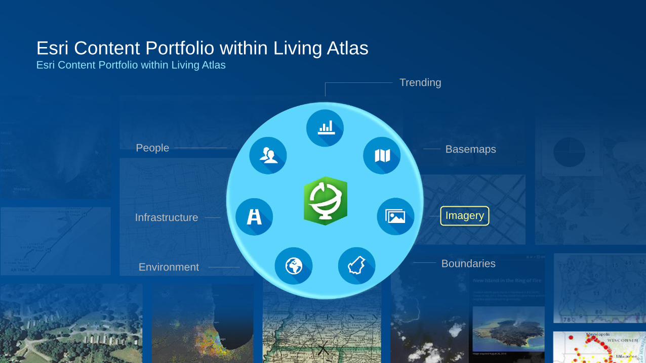
Esri Content Portfolio within Living AtlasEsri Content Portfolio within Living Atlas
Environment
Infrastructure
Boundaries
Imagery
BasemapsPeople
Trending

Esri Content Portfolio within Living AtlasEsri Content Portfolio within Living Atlas
Environment
Infrastructure
Boundaries
Imagery
BasemapsPeople
Trending

Basemaps
• Variety of Basemaps for Different Maps and Apps
- From neutral background maps to rich foreground maps, emphasizing human or physical worlds
• Now Available in both ‘Vector’ and ‘Raster’ Format
Suite of basemaps to support your web maps and applications
Reference Maps for our World and Context for Your Work

Esri Vector Basemaps
• Latest Version (v2) Released in December and Available to Use in Your Maps & Apps
- Enable to use in your ArcGIS Online Organization’s Basemap Gallery
• Now Includes Global Coverage of Large-scale Street data
- Using best available data from HERE, OpenStreetMap, and GIS Community
• Localization: ongoing efforts to localize the maps for different languages and regions
- Languages: now includes default (global+local) plus 6 more languages (New!)
- Chinese (Traditional), French, German, Japanese, Russian, and Spanish are now available.
- Disputed Places: vector basemaps enable different treatments of disputed places
- Custom views available or configurable (e.g. India, China, Korea, Europe, United States, etc.)
• New Vector Basemap Style Editor now available for users to create custom styles
- Browser based editor to create and save new vector basemaps (beta now available!)
What’s New

Esri Vector Basemaps
• More Localization: expand efforts to localize the maps for different languages
- Languages: will includes additional 6+ more languages soon, remainder to follow this year
- Arabic, Chinese (Simplified), Italian, Korean, Polish, Portuguese (Brazilian), prioritized by usage
• More Styles: Esri planning to publish some additional styles for different use cases
- New Political Style, Ocean Reference Layer for Ocean Basemap, …
- Additional styles to be developed by Esri cartographers using the Vector Style Editor app
• More Layers: additional layers in tiles to support existing and new styles
- Vector Hillshade, Contours, etc.
• Update Frequency: improve update frequency for selected data sources (e.g. HERE)
- Transition from Quarterly to Monthly updates of key data sources
What’s Next
Road Ahead

BasemapsFoundation maps in multiple styles

Esri Community Maps Editor App
• New Web App to Create Campus Features
- Any user can enhance the basemap in their area
What’s Next
Road Ahead

OpenStreetMapCollaborative Project by a Community of Mappers to Create a Free, Editable Map of the World
• Esri has enabled Access and Editing of OpenStreetMap for many Years
- Users: Featured Basemap in Online, Used in Esri Basemaps
- Contributors: ArcGIS Editor for OSM, Esri Imagery in OSM Editors
• OpenStreetMap Vector Basemap (New!)
- Esri providing a new vector basemap based on OSM data and cartography
- Map is created using ArcGIS Pro and hosted in ArcGIS Online
- Map will be updated every 2-3 weeks with the latest OSM data initially
- Over time, Esri intends to accelerate the pace of updates with a goal of continuously
- Map will be freely available to all users and developers to use in their maps and apps!
- Now in Beta release

OpenStreetMap
Vector Basemap

OpenStreetMap OfferingsWhat’s Next
• OpenStreetMap Data Layers (Coming Soon!)
- Esri to provide feature layers for OSM data to be used for visualization and analysis
• Layers will include Buildings, POIs, Streets, etc.
- Layers to be updated continuously with minutely diffs from OSM to present the latest updates!
- Layers can be easily re-styled in ArcGIS Online and used for local area analysis
• Feature layers will be available through ArcGIS Online in Groups and the Living Atlas
Road Ahead

OpenStreetMap
Data Layers
Road Ahead

OSM Database
ArcGIS Server map& feature service
ArcGIS.com& Other Apps
OSM - ArcGIS Online Integration
PostgreSQL 9.5.3PostGIS 2.2.x
ArcGIS OnlineHosted Feature Lyrs
Esri Content Systems
OSM Diffs
(minutely)
User Maps & Apps
Esri Content Portfolio within Living AtlasEsri Content Portfolio within Living Atlas
Environment
Infrastructure
Boundaries
Imagery
BasemapsPeople
Trending

World Imagery
• Multi-scale map featuring Most Recent, High-res imagery from Best Available Sources
- Major updates to World Imagery map in 2016-2018
• Updates with DigitalGlobe basemap imagery (began Q3 2016)
- Over 150 million sq. km. of imagery updated in past 1.5 years
- Updates will continue in remainder of 2018 and beyond …
• Updates from GIS User imagery through Community Maps
- Hundreds of contributions from national, provincial, and local sources
- Austria, Netherlands, New Zealand, Spain, Switzerland, City of Berlin, Many U.S. & Canadian Cities, …
Esri’s flagship imagery basemap
UAE Presidential Palace (Aug ‘16)

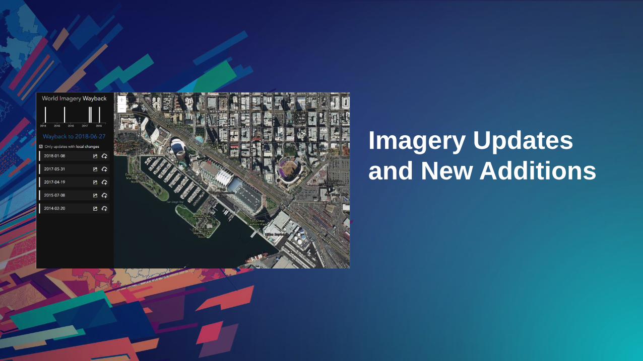
World Imagery (Wayback)Multiple Vintages of the World Imagery map from our Archive (now in Beta release)
• Over 80 Versions of World Imagery going back ~5 years
- Initially releases from January 2014 through June 2018
- Published as performant and scalable basemap tile layers
• View Change over Time
- Reveals typically 3-5 different views of an area in recent years
• Lock In to a Specific Version
- Reference a specific version for your AOI (e.g. community imagery)
- Preserve the ‘current state’ at the time of your analysis
• During Beta, Esri will be Adding More Imagery from Archive
2014 2015 2016 2017 2018

Sentinel-2 ImageryGlobal 10m imagery for Earth observation
• Continuity with the SPOT and Landsat missions
• Multispectral
- 13 spectral bands (4-10m, 6-20m, 3-60m)
- 3 Red-Edge bands for enhanced vegetative analysis
• Multitemporal
- Location revisit every 5 days
- Last 14 months available via ArcGIS Online
- Updated daily with latest available imagery
• Hosted in Amazon Web Services - Frankfurt Region
• Open access via Sentinel Explorer
• Full access with ArcGIS subscription (no credits)
Sentinel-2 is part of the European Commission (EC) Earth observation program - Copernicus
Imagery courtesy of the European Space Agency (ESA)

NAIP ImageryNationwide 1m or better resolution imagery for the Continental United States
• Nationwide Image Service
- Imagery provided courtesy of USDA FSA
• Multi-band (4-band) Imagery
- Supports Natural Color, Color Infrared, NDVI
• Imagery available for the Past 8 Years
- Starting with NAIP 2010 through Latest
- Updated with All NAIP 2017 Imagery Now!
• Available with ArcGIS Online Subscription
• What’s Next: NAIP Tile Layer
- High-Performance hosted tile layer of NAIP imagery
- Features the most recent imagery for each state in natural color
- Ideal for use as basemap of NAIP only imagery
Imagery Updates
and New Additions
Premium Imagery OptionsAdditional sources of high-quality imagery that is available for a fee
• Additional Sources of Imagery available in ArcGIS Marketplace (Now)
- Nearmap US & AU PhotoMaps: 7.5cm imagery of metro areas updated frequently
- CycloMedia Street Smart
• Considering New Premium Imagery Options via Esri and Partners (Next)
- More Recent and/or Detailed Satellite Imagery for the World
- 30-50cm imagery with a typical currency of 3-6 months
- More Recent High-Resolution Aerial Imagery for the United States and/or Europe
- 20cm or better imagery captured 1 or more times per year, available for small-to-large areas
- Contacts: Deane Kensok ([email protected]) or Robert Waterman ([email protected])
Road Ahead

Premium Imagery

Esri Content Portfolio within Living AtlasEsri Content Portfolio within Living Atlas
Environment
Infrastructure
Boundaries
Imagery
BasemapsPeople
Trending
Elevation data Now includes Airbus WorldDEM4OrthoWhat’s New
• Global pole to pole
- exceptions Azerbaijan, DR Congo, Ukraine
• 0.8 arc sec (~ 24.7 meter) resolution
- 4 meter vertical accuracy* at global scale
• Improvements to:
- World Elevation Image Service (Terrain & TopoBathy)
- Elevation Analysis Services (Profile, Viewshed, Summarize)
- 3D Elevation (Terrain3D & TopoBathy3D)
- World Hillshade (coming soon)
- World Topo Base (coming soon)
* Excluding urban areas (DTM like areas), substituted areas, areas of Antarctica
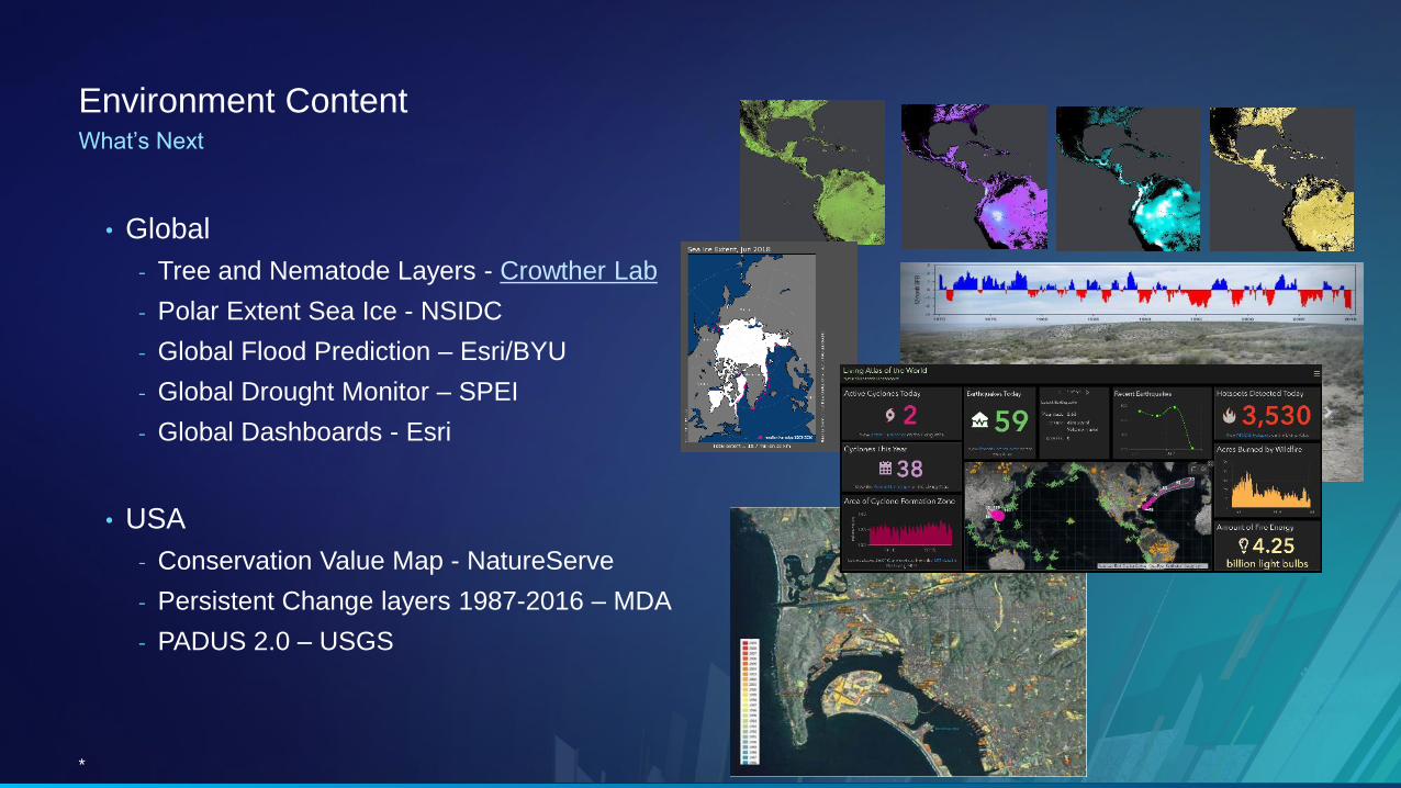
Environment ContentWhat’s Next
• Global
- Tree and Nematode Layers - Crowther Lab
- Polar Extent Sea Ice - NSIDC
- Global Flood Prediction – Esri/BYU
- Global Drought Monitor – SPEI
- Global Dashboards - Esri
• USA
- Conservation Value Map - NatureServe
- Persistent Change layers 1987-2016 – MDA
- PADUS 2.0 – USGS
*

Please Take Our Survey on the App
Download the Esri Events
app and find your event
Select the session
you attended
Scroll down to find the
feedback section
Complete answers
and select “Submit”
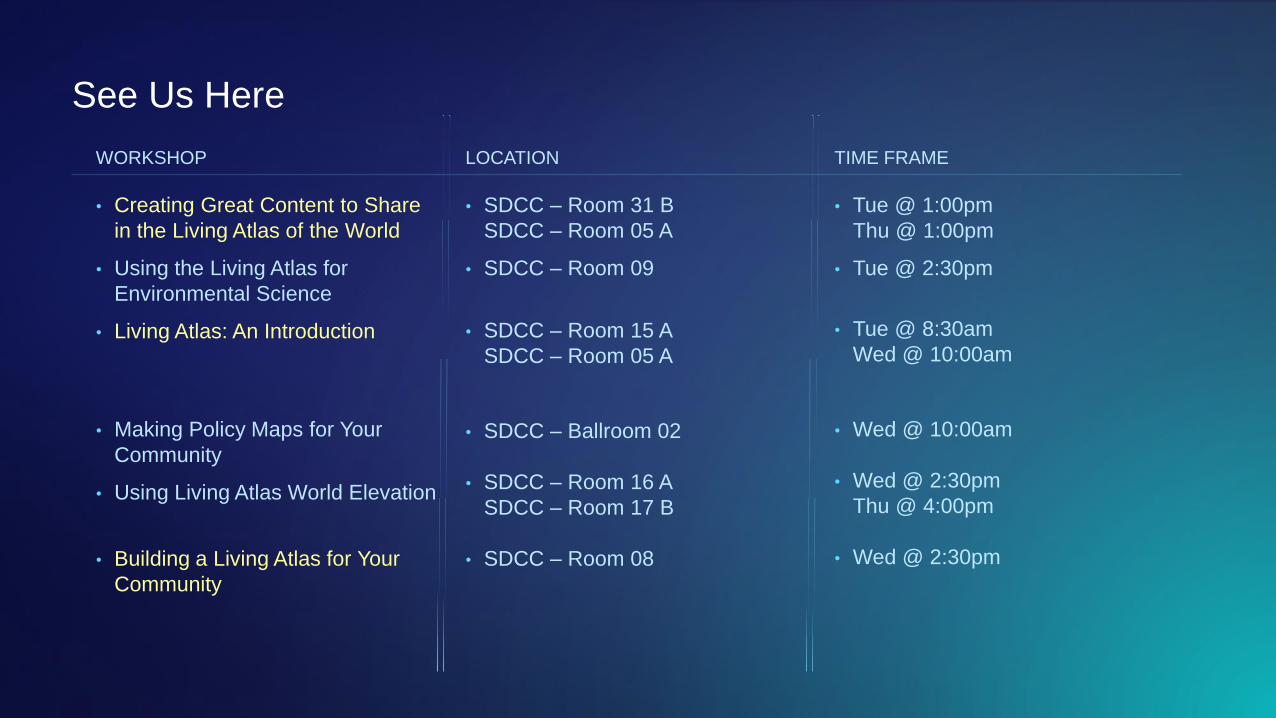
See Us Here
• Creating Great Content to Share
in the Living Atlas of the World
• Using the Living Atlas for
Environmental Science
• Living Atlas: An Introduction
• Making Policy Maps for Your
Community
• Using Living Atlas World Elevation
• Building a Living Atlas for Your
Community
WORKSHOP LOCATION
• SDCC – Room 31 B
SDCC – Room 05 A
• SDCC – Room 09
• SDCC – Room 15 A
SDCC – Room 05 A
• SDCC – Ballroom 02
• SDCC – Room 16 A
SDCC – Room 17 B
• SDCC – Room 08
TIME FRAME
• Tue @ 1:00pm
Thu @ 1:00pm
• Tue @ 2:30pm
• Tue @ 8:30am
Wed @ 10:00am
• Wed @ 10:00am
• Wed @ 2:30pm
Thu @ 4:00pm
• Wed @ 2:30pm