DRAFT South Boston Waterfront District Municipal Harbor Plan Renewal and Amendment MHPAC 4.22.16
DRAFT Port Douglas Waterfront Amendment - 2010 No.1 #2576228V7
Proposed Amendment
Planning Scheme for the Douglas Shire - Port Douglas Waterfront Amendment
Amendment Reference 2010 No. 1
SEPARATE ATTACHMENT TO CLAUSE 10 - ORDINARY MEETING 24 AUGUST 2011
DRAFT Port Douglas Waterfront Amendment - 2010 No.1 #2576228V7
Document Development History Build Status: Version Date Author Reason Status
1.0 19/05/2010 Paul Cohen Proposal Endorsed for State Interest Review
2.0 18/08/2010 Paul Cohen Response to State Interest Comments
Endorsed by DIP on 25/10/2010
3.0 15/11/2010 Paul Cohen Public Notification Issued
4.0 4/03/2011 Paul Cohen Response to submissions
Draft
5.0 18/03/2011 Paul Cohen Issue to Council Endorsed for Second State Interest Review on 23/03/2011
6.0 31/03/2011 Paul Cohen Issue to DLGP Issued
7.0 9/06/2011 Paul Cohen DLGP Endorsed Issue to Council
Amendments in this V2 Release: Section Title Section
Number Page Amendment Summary
Tables of Assessment Table 1 I Amended Caretaker’s Residence – Code Assessment in Port Douglas Waterfront South Planning Area to have yellow square
Tables of Assessment Table 2 III Deleted Prescribed Tidal Works from Table of Assessment Port Douglas & Environs Locality Code
4.2.4 65-66 Deleted “a)” from A2.1a) in Self-Assessment Criteria description in the applicability statement
Port Douglas & Environs Locality Code
4.2.4 76 Deleted “in” from the second line of A23.2
Port Douglas Waterfront North Planning Area Code
4.3.10 157 Inserted “and” between Inlet mitigates (second dot point) in purpose statement
Port Douglas Waterfront North Planning Area Code
4.3.10 157 Inserted “of” between use landscaping (tenth dot point) in purpose statement
Port Douglas Waterfront North Planning Area Code
4.3.10 158 Deleted “Operational Work – Prescribed Tidal Work;” from Applicability Statement.
Port Douglas Waterfront North Planning Area Code
4.3.10 158 Inserted “Elements of the Code” heading above the Code provisions
Port Douglas Waterfront North Planning Area Code
4.3.10 158 Inserted the following statements “For self-assessable development assessed against this Code, the applicable Acceptable Solutions are A1.1 and A2.1. Self assessable development which does not comply with Acceptable Solutions as listed above, outlined in this Code will require Code Assessment.”
Port Douglas Waterfront North Planning Area Code
4.3.10 158 Inserted Inconsistent Uses Performance Criterion and Acceptable Solution as per other Codes. Amended numbering of Performance Criteria and Acceptable Solutions thereafter.
Port Douglas Waterfront North Planning Area Code
4.3.10 158 Amended code structure - elevated Former P2 and A2.1 to new P2 and A2.1. Former P1 and A1.1 and A1.2 are now P3 and A3.1 and A3.2
DRAFT Port Douglas Waterfront Amendment - 2010 No.1 #2576228V7
Section Title Section Number
Page Amendment Summary
Port Douglas Waterfront North Planning Area Code
4.3.10 158 Deleted “;and” at end of A3.2 (was A1.2)
Port Douglas Waterfront North Planning Area Code
4.3.10 160 Amended A8.3 (was A7.3) to use the word “is” instead of “are”
Port Douglas Waterfront North Planning Area Code
4.3.10 160 Amended order of A8.4 and A8.5 (was 7.4 and 7.5) reversed.
Port Douglas Waterfront North Planning Area Code
4.3.10 161 Amended A8.4 (was A7.5) to remove negative “is not located” to “is located away from”; and Deleted “on” from a.; and Deleted “near” from b.
Port Douglas Waterfront North Planning Area Code
4.3.10 161 Amended P9 (was P8) to read as “New buildings promote exemplary environmentally sustainable building design outcomes.”
Port Douglas Waterfront North Planning Area Code
4.3.10 162 Amended A10.4 (was A9.4) to refer to “Schedule 1 of the Vehicle Parking and Access Code” instead of the “Parking and Access Codes”.
Port Douglas Waterfront North Planning Area Code
4.3.10 163 Inserted “public” between A plaza in P13 (was P12).
Port Douglas Waterfront North Planning Area Code
4.3.10 164 Inserted “Port Douglas” in front of Waterfront South Planning Area in A18.1 (was A17.1).
Port Douglas Waterfront South Planning Area Code
4.3.11 165 Amended second and third dot points in purpose statement to remove “and service industry”
Port Douglas Waterfront South Planning Area Code
4.3.11 164 Deleted “Operational Work – Prescribed Tidal Work;” from Applicability Statement.
Port Douglas Waterfront South Planning Area Code
4.3.11 165 Amended Inconsistent Uses Performance Criterion and Acceptable Solution to become first Performance Criterion and Acceptable Measures as per other Codes. Amended numbering of Performance Criteria and Acceptable Solutions thereafter.
Port Douglas Waterfront South Planning Area Code
4.3.11 166 Deleted “;and” at end of A6.3
Reconfiguring a Lot Code
4.6.5 265 Amended Table 1minimum lot dimensions and sizes to allow for reconfiguration of land where it will allow development to comply with Port Douglas Waterfront South Planning Area
Administrative definitions
5.3.2 From 326 Amended definition of Marine-based Industry.
Amendments in this V4 and V5 Release: Section Title Section
Number Page Amendment Summary
Port Douglas Waterfront North Planning Area Code
4.3.10 159 Deleted “, bars” from A4.1
Port Douglas Waterfront North Planning Area Code
4.3.10 163 Deleted “is provided” from A12.1
Port Douglas Waterfront South Planning Area Code
4.3.11 165 Amended Performance Criterion P3 and Acceptable Measures A3.1, A3.2 and A3.3.
Land Use Definitions 5.1.2 From 326 Amended definition of Marina.
DRAFT Port Douglas Waterfront Amendment - 2010 No.1 #2576228V7
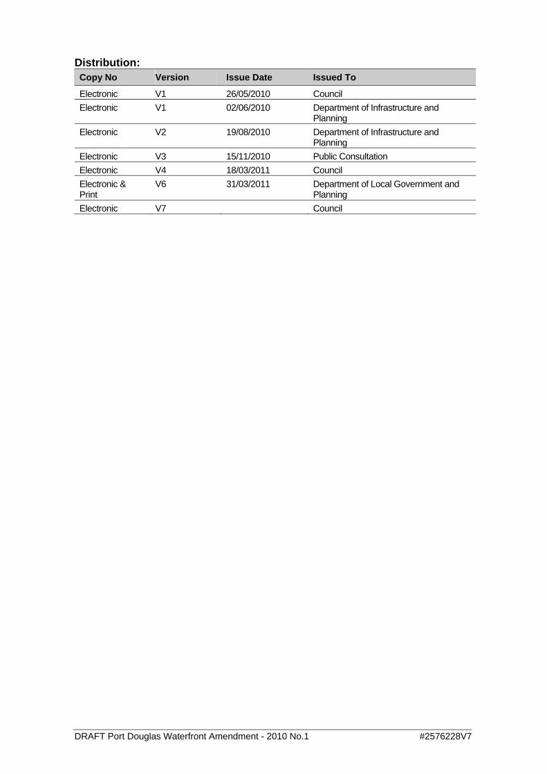
Distribution: Copy No Version Issue Date Issued To
Electronic V1 26/05/2010 Council Electronic V1 02/06/2010 Department of Infrastructure and
Planning Electronic V2 19/08/2010 Department of Infrastructure and
Planning Electronic V3 15/11/2010 Public Consultation Electronic V4 18/03/2011 Council Electronic & Print
V6 31/03/2011 Department of Local Government and Planning
Electronic V7 Council
DRAFT Port Douglas Waterfront Amendment - 2010 No.1 #2576228V7
August 2006 Page 6
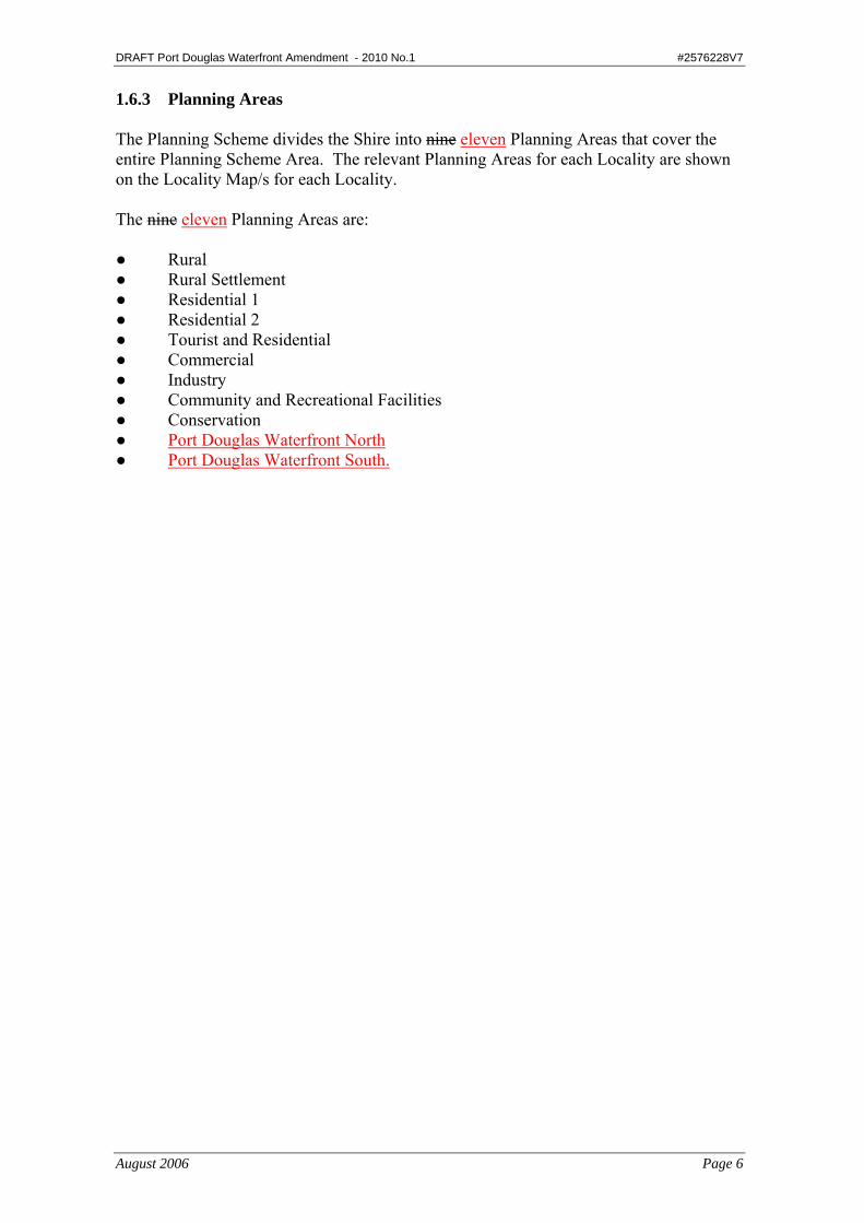
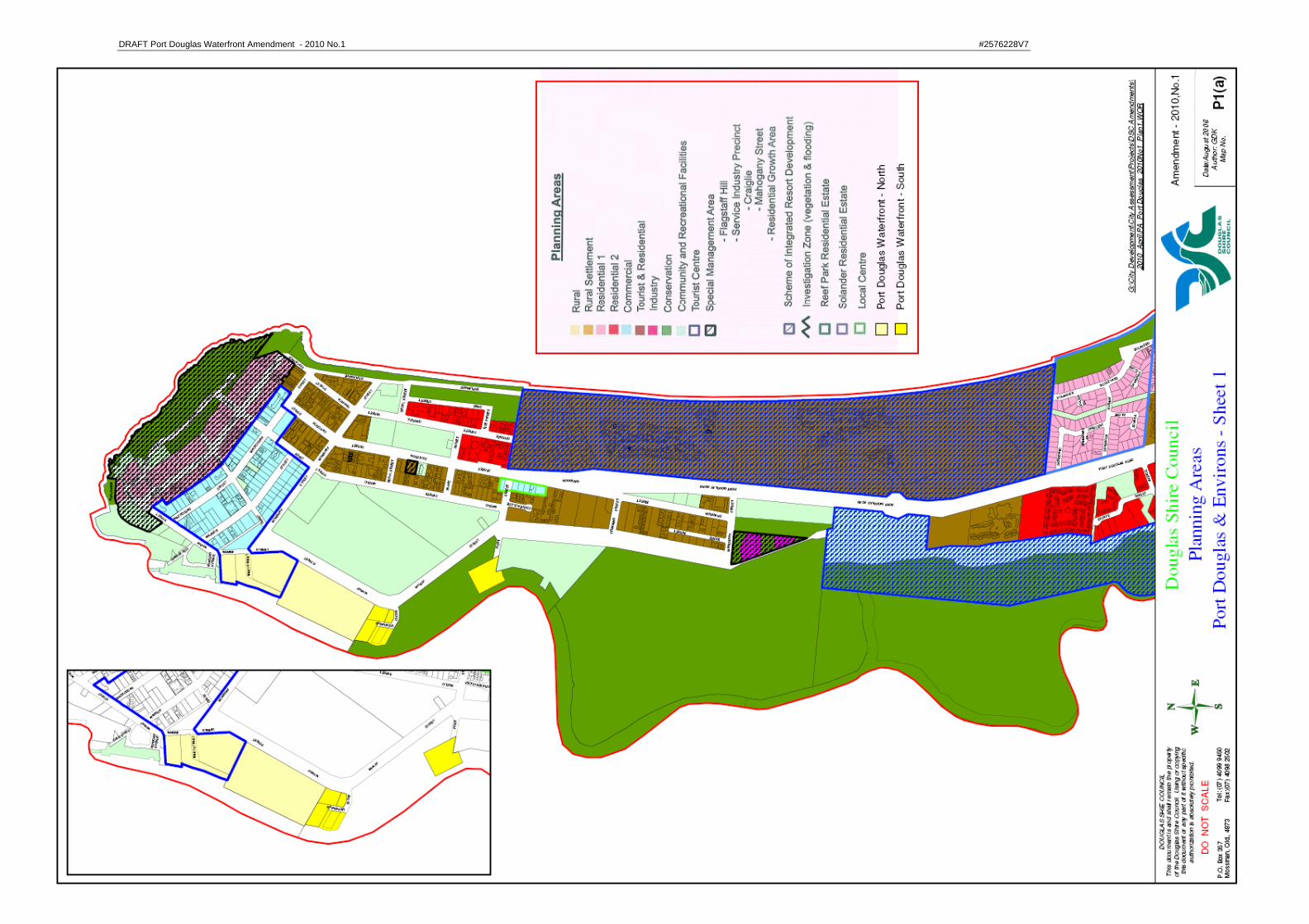
1.6.3 Planning Areas The Planning Scheme divides the Shire into nine eleven Planning Areas that cover the entire Planning Scheme Area. The relevant Planning Areas for each Locality are shown on the Locality Map/s for each Locality. The nine eleven Planning Areas are: ● Rural ● Rural Settlement ● Residential 1 ● Residential 2 ● Tourist and Residential ● Commercial ● Industry ● Community and Recreational Facilities ● Conservation ● Port Douglas Waterfront North ● Port Douglas Waterfront South.

DRAFT Port Douglas Waterfront Amendment - 2010 No.1 #2576228V7
August 2006 Page 7
1.6.6 Codes The Planning Scheme includes five different types of Codes. The Codes are: ● Locality Codes ● Planning Area Codes ● Overlay Codes ● Land Use Codes ● General Codes. The Codes set out the development requirements for development in the Shire. Where there is any inconsistency between the requirements of the applicable Codes, any Land Use Code takes precedence. Where there is an inconsistency or conflict between the requirements of the applicable codes for development, the inconsistency or conflict is to be resolved as follows:-
• The achievement of the purpose and performance criteria of an Overlay Code is a priority development outcome and must be demonstrated. Where there is a true conflict between achievement of the purpose or performance criteria of an Overlay Code and the purpose or performance criteria of other applicable codes, the applicant must demonstrate how the development can achieve the purpose and performance criteria of the applicable Overlay Code.
• The achievement of the purpose and performance criteria of a Locality Code is a preferred development outcome where there is a true conflict between the requirements of a Locality Area Code and the achievement of the purpose or performance criteria of an applicable Planning Area Code or a Land Use Code.
• The achievement of the purpose and performance criteria of a Planning Area Code is a preferred development outcome where there is a true conflict between the requirements of a Planning Area Code and the achievement of the purpose or performance criteria of an applicable Land Use Code.
• The achievement of the purpose and performance criteria of a Land Use Code is a preferred development outcome where there is a true conflict between the requirements of a Land Use Code and the achievement of the purpose or performance criteria of an applicable General Code.
DRAFT Port Douglas Waterfront Amendment - 2010 No.1 #2576228V7
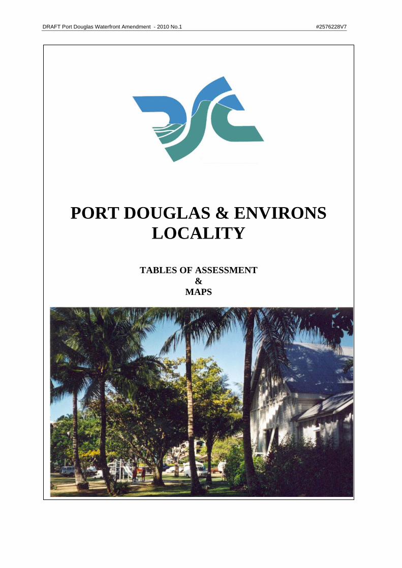
PORT DOUGLAS & ENVIRONS
LOCALITY
TABLES OF ASSESSMENT &
MAPS
DRAFT Port Douglas Waterfront Amendment - 2010 No.1 #2576228V7
August, 2006 Page I
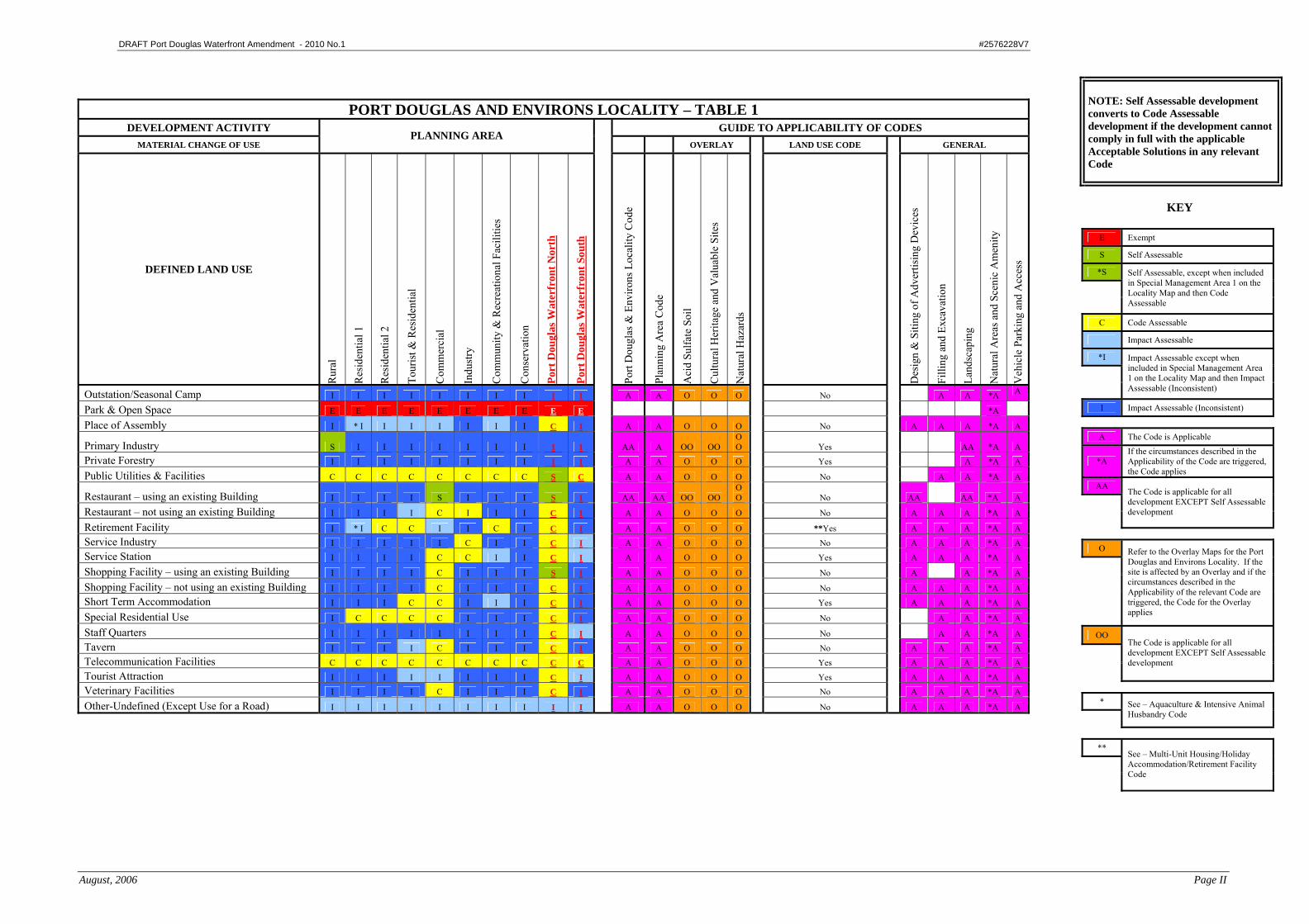
PORT DOUGLAS AND ENVIRONS LOCALITY – TABLE 1
DEVELOPMENT ACTIVITY GUIDE TO APPLICABILITY OF CODES MATERIAL CHANGE OF USE
PLANNING AREA OVERLAY LAND USE CODE GENERAL
DEFINED LAND USE
Rur
al
Res
iden
tial 1
Res
iden
tial 2
Tour
ist &
Res
iden
tial
Com
mer
cial
Indu
stry
Com
mun
ity &
Rec
reat
iona
l Fac
ilitie
s
Con
serv
atio
n
Port
Dou
glas
Wat
erfr
ont N
orth
Port
Dou
glas
Wat
erfr
ont S
outh
Port
Dou
glas
& E
nviro
ns L
ocal
ity C
ode
Plan
ning
Are
a C
ode
Aci
d Su
lfate
Soi
l
Cul
tura
l Her
itage
and
Val
uabl
e Si
tes
Nat
ural
Haz
ards
Des
ign
& S
iting
of A
dver
tisin
g D
evic
es
Filli
ng a
nd E
xcav
atio
n
Land
scap
ing
Nat
ural
Are
as a
nd S
ceni
c A
men
ity
Veh
icle
Par
king
and
Acc
ess
Aircraft Landing Facility - Commercial I I I I I I I I I I A A O O O Yes A A A *A A
Aquaculture I I I I I I I I C I A A O O O *Yes A A A *A A
Business Facilities – using an existing Building I I I I S I I I S I AA AA OO OO OO No AA AA *A A
Business Facilities – not using an existing Building I I I I C I I I C I A A O O O No A A A *A A Camping Ground I I I I I I I I I I A A O O O Yes A A A *A A Caravan Park I I I I I I I I I I A A O O O Yes A A A *A A Caretaker's Residence C I I I C C C I S C A A O O O Yes A A *A A Car Park I I I I I I I I C I A A O O O Yes A A A *A A
Cemetery & Crematorium I I I I I I C I I I A A O O O No A A A *A A
Child Care Centre I * I I I C I C I C I A A O O O Yes A A A *A A
Display Facilities I I I I I I I I C I A A O O O Yes A A A *A A
Educational Establishment I I I I I I I I C I A A O O O No A A A *A A Extractive Industry I I I I I I I I I I A A O O O Yes A A A *A A Health Facility I I I I C I I I C I A A O O O No A A A *A A Holiday Accommodation I I I C C I I I C I A A O O O **Yes A A A *A A
Home Activity I C C C C I I I S I A A O O O Yes A A *A A
Home Based Business I C C C C I I I C I A A O O O Yes A A A *A A Home Industry I I I I I I I I C I A A O O O No A A *A
House S * S S S I I I I I I A A OO OO OO Yes AA AA *A A
Indoor Sports & Entertainment I I I I C I C I C I A A O O O No A A A *A A Industry I I I I I C I I I I A A O O O No A A A *A A
Intensive Animal Husbandry C I I I I I I I I I A A O O O *Yes A A A *A A
Interpretive Facility I I I I I I C I S I A A O O O Yes A A A *A A Marina I I I I I I I I C I A A O O O No A A A *A A Multi-Unit Housing I * I C C I I I I C I A A O O O **Yes A A A *A A Off Premises Advertising Device I I I I I I I I I I A A O O O No A A *A Outdoor Sport & Recreation I I I I I I C I C I A A O O O No A A A *A A
NOTE: Self Assessable development converts to Code Assessable development if the development cannot comply in full with the applicable Acceptable Solutions in any relevant Code
KEY
E Exempt
S Self Assessable
*S
Self Assessable, except when included in Special Management Area 1 on the Locality Map and then Code Assessable
C Code Assessable
I Impact Assessable
*I
Impact Assessable except when included in Special Management Area 1 on the Locality Map and then Impact Assessable (Inconsistent)
I Impact Assessable (Inconsistent)
A The Code is Applicable
*A If the circumstances described in the Applicability of the Code are triggered, the Code applies
AA
The Code is applicable for all development EXCEPT Self Assessable development
O
Refer to the Overlay Maps for the Port Douglas and Environs Locality. If the site is affected by an Overlay and if the circumstances described in the Applicability of the relevant Code are triggered, the Code for the Overlay applies
OO
The Code is applicable for all development EXCEPT Self Assessable development
*
See – Aquaculture & Intensive Animal Husbandry Code
**
See – Multi-Unit Housing/Holiday Accommodation/Retirement Facility Code
DRAFT Port Douglas Waterfront Amendment - 2010 No.1 #2576228V7
August, 2006 Page II
PORT DOUGLAS AND ENVIRONS LOCALITY – TABLE 1 DEVELOPMENT ACTIVITY GUIDE TO APPLICABILITY OF CODES
MATERIAL CHANGE OF USE PLANNING AREA
OVERLAY LAND USE CODE GENERAL
DEFINED LAND USE
Rur
al
Res
iden
tial 1
Res
iden
tial 2
Tour
ist &
Res
iden
tial
Com
mer
cial
Indu
stry
Com
mun
ity &
Rec
reat
iona
l Fac
ilitie
s
Con
serv
atio
n
Port
Dou
glas
Wat
erfr
ont N
orth
Port
Dou
glas
Wat
erfr
ont S
outh
Port
Dou
glas
& E
nviro
ns L
ocal
ity C
ode
Plan
ning
Are
a C
ode
Aci
d Su
lfate
Soi
l
Cul
tura
l Her
itage
and
Val
uabl
e Si
tes
Nat
ural
Haz
ards
Des
ign
& S
iting
of A
dver
tisin
g D
evic
es
Filli
ng a
nd E
xcav
atio
n
Land
scap
ing
Nat
ural
Are
as a
nd S
ceni
c A
men
ity
Veh
icle
Par
king
and
Acc
ess
Outstation/Seasonal Camp I I I I I I I I I I A A O O O No A A *A A
Park & Open Space E E E E E E E E E E *A
Place of Assembly I * I I I I I I I C I A A O O O No A A A *A A
Primary Industry S I I I I I I I I I AA A OO OO OO Yes AA *A A
Private Forestry I I I I I I I I I I A A O O O Yes A *A A
Public Utilities & Facilities C C C C C C C C S C A A O O O No A A *A A
Restaurant – using an existing Building I I I I S I I I S I AA AA OO OO OO No AA AA *A A
Restaurant – not using an existing Building I I I I C I I I C I A A O O O No A A A *A A
Retirement Facility I * I C C I I C I C I A A O O O **Yes A A A *A A Service Industry I I I I I C I I C I A A O O O No A A A *A A Service Station I I I I C C I I C I A A O O O Yes A A A *A A
Shopping Facility – using an existing Building I I I I C I I I S I A A O O O No A A *A A
Shopping Facility – not using an existing Building I I I I C I I I C I A A O O O No A A A *A A Short Term Accommodation I I I C C I I I C I A A O O O Yes A A A *A A
Special Residential Use I C C C C I I I C I A A O O O No A A *A A
Staff Quarters I I I I I I I I C I A A O O O No A A *A A Tavern I I I I C I I I C I A A O O O No A A A *A A Telecommunication Facilities C C C C C C C C C C A A O O O Yes A A A *A A Tourist Attraction I I I I I I I I C I A A O O O Yes A A A *A A Veterinary Facilities I I I I C I I I C I A A O O O No A A A *A A
Other-Undefined (Except Use for a Road) I I I I I I I I I I A A O O O No A A A *A A
NOTE: Self Assessable development converts to Code Assessable development if the development cannot comply in full with the applicable Acceptable Solutions in any relevant Code
KEY
E Exempt
S Self Assessable
*S
Self Assessable, except when included in Special Management Area 1 on the Locality Map and then Code Assessable
C Code Assessable
Impact Assessable
*I
Impact Assessable except when included in Special Management Area 1 on the Locality Map and then Impact Assessable (Inconsistent)
I Impact Assessable (Inconsistent)
A The Code is Applicable
*A If the circumstances described in the Applicability of the Code are triggered, the Code applies
AA
The Code is applicable for all development EXCEPT Self Assessable development
O
Refer to the Overlay Maps for the Port Douglas and Environs Locality. If the site is affected by an Overlay and if the circumstances described in the Applicability of the relevant Code are triggered, the Code for the Overlay applies
OO
The Code is applicable for all development EXCEPT Self Assessable development
*
See – Aquaculture & Intensive Animal Husbandry Code
**
See – Multi-Unit Housing/Holiday Accommodation/Retirement Facility Code

DRAFT Port Douglas Waterfront Amendment - 2010 No.1 #2576228V7
August, 2006 Page III
PORT DOUGLAS AND ENVIRONS LOCALITY – TABLE 2
GUIDE TO APPLICABILITY OF CODES DEVELOPMENT ACTIVITY PLANNING AREA
OVERLAY GENERAL
Rur
al
Res
iden
tial 1
Res
iden
tial 2
Tour
ist &
Res
iden
tial
Com
mer
cial
Indu
stry
Com
mun
ity &
Rec
reat
iona
l Fac
ilitie
s
Con
serv
atio
n
Port
Dou
glas
Wat
erfr
ont N
orth
Port
Dou
glas
Wat
erfr
ont S
outh
Port
Dou
glas
& E
nviro
ns L
ocal
ity C
ode
Plan
ning
Are
a
Aci
d Su
lfate
Soi
ls
Cul
tura
l Her
itage
& V
alua
ble
Site
s
Nat
ural
Haz
ards
Des
ign
& S
iting
of A
dver
tisin
g D
evic
es
Filli
ng &
Exc
avat
ion
Land
scap
ing
Nat
ural
Are
as a
nd S
ceni
c A
men
ity
Rec
onfig
urin
g a
Lot
Reconfiguring a Lot C C C C C C C I C C
A A O O O
*A A
Operational Work Associated with Reconfiguring a Lot C C C C C C C C C C
A A O O O
A A *A A
Operational Work - Filling or Excavation not associated with a Material Change of Use C C C C C C C C C C
A A O O O
A *A
Operational Work - Engineering Works not associated with a Material Change of Use C C C C C C C C C C
A A O O O
A *A
Operational Work - Placing an Advertising Device on Premises not associated with a Material Change of Use C C C C C C C C C C
A A
A *A
Operational Work - Prescribed Tidal Work C C C C C C C C C C
A
Building Work other than Minor Building Work not associated with a Material Change of Use E E E E E E E C C C
A A
*A
KEY E Exempt
S Self Assessable
C Code Assessable
I Impact Assessable
I Impact Assessable (Inconsistent)
A The Code is Applicable
*A If the circumstances described in the Applicability of the Code are triggered, the Code applies
O
Refer to the Overlay Maps for the Port Douglas and Environs Locality. If the site is affected by an Overlay and if the circumstances described in the Applicability of the relevant Code are triggered, the Code for the Overlay applies
NOTE: Self Assessable development converts to Code Assessable development if the development cannot comply in full with the applicable Acceptable Solutions in any relevant Code
DRAFT Port Douglas Waterfront Amendment - 2010 No.1 #2576228V7

DRAFT Port Douglas Waterfront Amendment - 2010 No.1 #2576228V7
DRAFT Port Douglas Waterfront Amendment - 2010 No.1 #2576228V7

DRAFT Port Douglas Waterfront Amendment - 2010 No.1 #2576228V7
DRAFT Port Douglas Waterfront Amendment - 2010 No.1 #2576228V7
August, 2006 Page 15
4.1 Introduction The Codes relevant to the Planning Scheme are detailed below in specific groups and in alphabetical order, followed by each Code outlined in detail. A Code that is applicable to a material change of use is also applicable to the ongoing use that results from that change1. Self Assessable development which does not comply with the applicable Acceptable Solutions outlined in the Codes will require Code Assessment. Codes for Localities ● World Heritage Areas and Environs Locality ● Settlement Areas North of the Daintree River Locality ● Mossman and Environs Locality ● Port Douglas and Environs Locality ● Coastal Suburbs, Villages and Townships Locality ● Rural Areas and Rural Settlements Locality. Codes for Planning Areas ● Rural Planning Area ● Rural Settlement Planning Area ● Residential 1 Planning Area ● Residential 2 Planning Area ● Tourist and Residential Planning Area ● Commercial Planning Area ● Industry Planning Area ● Community and Recreational Facilities Planning Area ● Conservation Planning Area ● Port Douglas Waterfront North Planning Area ● Port Douglas Waterfront South Planning Area Codes for Overlays ● Acid Sulfate Soils ● Cultural Heritage and Valuable Sites ● Natural Hazards.
1 IPA, Section 2.1.23 (3) (Local Planning Instruments have Force of Law) relates with respect to regulating the use of premises, and also IPA, Section 4.3.4 (Compliance with Identified Code for Use of Premises) with respect to an offence under the Act.

DRAFT Port Douglas Waterfront Amendment - 2010 No.1 #2576228V7
August, 2006 Page 65
4.2.4 Port Douglas and Environs Locality Code Purpose The purpose of this Code is to facilitate the achievement of the following outcomes for the Port Douglas and Environs Locality: • consolidate Port Douglas as the major tourist accommodation and tourist service
centre in the Shire; • ensure that tourist development and associated Landscaping is of high quality
which reflects and complements the image of Port Douglas as a tropical seaside resort town of international renown;
• consolidate the area between Macrossan Street and Marina Mirage as the major tourist, retail, dining and entertainment centre of the Shire;
• ensure that all forms of development complement the tropical image of the town by incorporating attractive design and architectural features;
• encourage the expansion of residential areas that are pleasant, functional, distinctive and in visually well-defined areas;
• protect existing and future residential areas from the intrusion of tourist accommodation and activity;
• protect sensitive environments and natural features which give Port Douglas its distinctive character and identity, in particular Four Mile Beach, Dicksons Inlet and Flagstaff Hill;
• protect the surrounding rural and natural environments from intrusion by urban development;
• maintain the distinct rural hinterland, dominant natural environment of the western escarpment, and the existing vegetated hillside of Flagstaff Hill; and
• protect primary functions of the port (marine and fishing activities) from incompatible land uses and acknowledge the industrial and commercial land uses associated with the maritime industry, while also providing secondary opportunities for recreational use by residents and tourists.
Applicability
This Code applies to self assessable and assessable development in the Port Douglas and Environs Locality for:
• Material Change of Use:
Except for: - Business Facilities – using an existing Building in the Commercial
Planning Area and the Port Douglas Waterfront North Planning Area - Primary Industry in the Rural Planning Area - Restaurant – using an existing Building in the Commercial Planning Area
and the Port Douglas Waterfront North Planning Area
• Reconfiguring a Lot; • Operational Work Associated with Reconfiguring a Lot; • Operational Work – Filling or Excavation not associated with a Material Change
of Use;
DRAFT Port Douglas Waterfront Amendment - 2010 No.1 #2576228V7
August, 2006 Page 66
• Operational Work – Engineering Works not associated with a Material Change of Use;
• Operational Work – Placing an Advertising Device on Premises not associated with a Material Change of Use; and
• Building Work other than Minor Building Work not associated with a Material Change of Use in the Conservation Planning Area.
For self-assessable development assessed against this Code, the applicable Acceptable Solutions are A1.1 and A2.1a). Self assessable development which does not comply with Acceptable Solutions as listed above, outlined in this Code will require Code Assessment.
DRAFT Port Douglas Waterfront Amendment - 2010 No.1 #2576228V7
August, 2006 Page 67
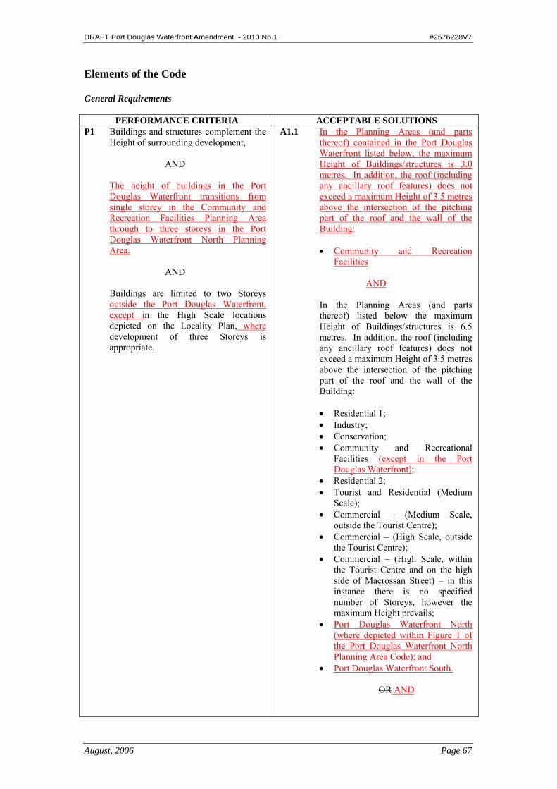
Elements of the Code General Requirements
PERFORMANCE CRITERIA ACCEPTABLE SOLUTIONS P1 Buildings and structures complement the
Height of surrounding development,
AND The height of buildings in the Port
Douglas Waterfront transitions from single storey in the Community and Recreation Facilities Planning Area through to three storeys in the Port Douglas Waterfront North Planning Area.
AND
Buildings are limited to two Storeys
outside the Port Douglas Waterfront, except in the High Scale locations depicted on the Locality Plan, where development of three Storeys is appropriate.
A1.1 In the Planning Areas (and parts thereof) contained in the Port Douglas Waterfront listed below, the maximum Height of Buildings/structures is 3.0 metres. In addition, the roof (including any ancillary roof features) does not exceed a maximum Height of 3.5 metres above the intersection of the pitching part of the roof and the wall of the Building: • Community and Recreation
Facilities
AND In the Planning Areas (and parts
thereof) listed below the maximum Height of Buildings/structures is 6.5 metres. In addition, the roof (including any ancillary roof features) does not exceed a maximum Height of 3.5 metres above the intersection of the pitching part of the roof and the wall of the Building: • Residential 1; • Industry; • Conservation; • Community and Recreational
Facilities (except in the Port Douglas Waterfront);
• Residential 2; • Tourist and Residential (Medium
Scale); • Commercial – (Medium Scale,
outside the Tourist Centre); • Commercial – (High Scale, outside
the Tourist Centre); • Commercial – (High Scale, within
the Tourist Centre and on the high side of Macrossan Street) – in this instance there is no specified number of Storeys, however the maximum Height prevails;
• Port Douglas Waterfront North (where depicted within Figure 1 of the Port Douglas Waterfront North Planning Area Code); and
• Port Douglas Waterfront South.
OR AND
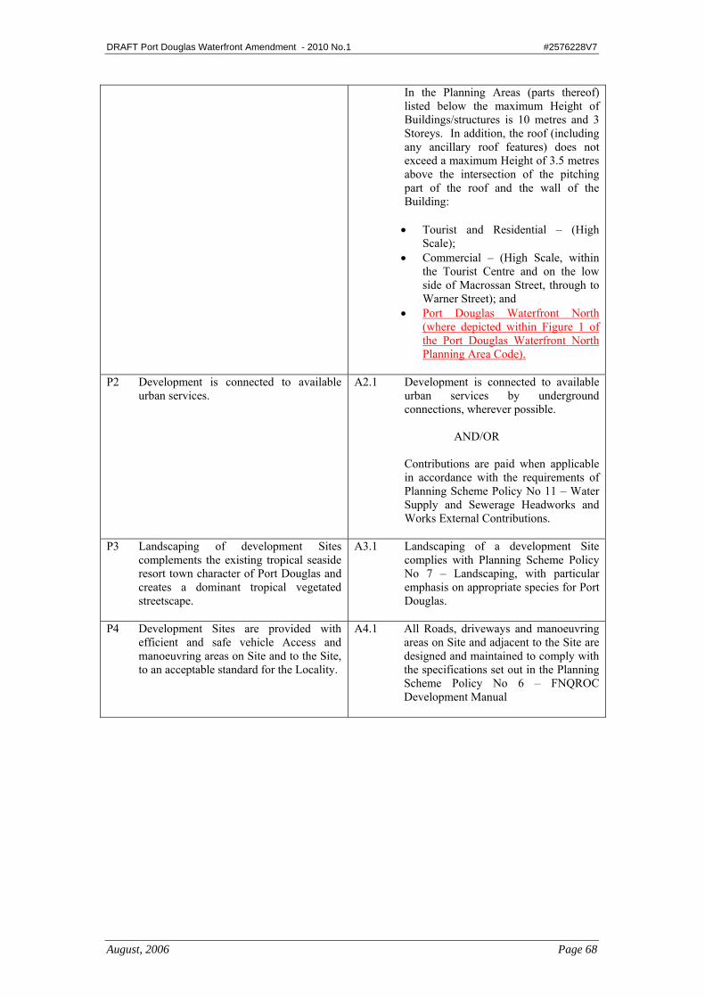
DRAFT Port Douglas Waterfront Amendment - 2010 No.1 #2576228V7
August, 2006 Page 68
In the Planning Areas (parts thereof) listed below the maximum Height of Buildings/structures is 10 metres and 3 Storeys. In addition, the roof (including any ancillary roof features) does not exceed a maximum Height of 3.5 metres above the intersection of the pitching part of the roof and the wall of the Building: • Tourist and Residential – (High
Scale); • Commercial – (High Scale, within
the Tourist Centre and on the low side of Macrossan Street, through to Warner Street); and
• Port Douglas Waterfront North (where depicted within Figure 1 of the Port Douglas Waterfront North Planning Area Code).
P2 Development is connected to available
urban services. A2.1 Development is connected to available
urban services by underground connections, wherever possible.
AND/OR
Contributions are paid when applicable
in accordance with the requirements of Planning Scheme Policy No 11 – Water Supply and Sewerage Headworks and Works External Contributions.
P3 Landscaping of development Sites
complements the existing tropical seaside resort town character of Port Douglas and creates a dominant tropical vegetated streetscape.
A3.1 Landscaping of a development Site complies with Planning Scheme Policy No 7 – Landscaping, with particular emphasis on appropriate species for Port Douglas.
P4 Development Sites are provided with
efficient and safe vehicle Access and manoeuvring areas on Site and to the Site, to an acceptable standard for the Locality.
A4.1 All Roads, driveways and manoeuvring areas on Site and adjacent to the Site are designed and maintained to comply with the specifications set out in the Planning Scheme Policy No 6 – FNQROC Development Manual
DRAFT Port Douglas Waterfront Amendment - 2010 No.1 #2576228V7
August, 2006 Page 69
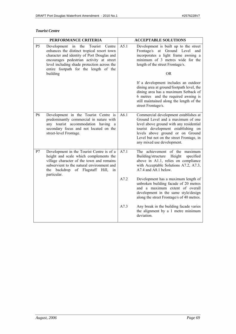
Tourist Centre
PERFORMANCE CRITERIA ACCEPTABLE SOLUTIONS P5 Development in the Tourist Centre
enhances the distinct tropical resort town character and identity of Port Douglas and encourages pedestrian activity at street level including shade protection across the entire footpath for the length of the building
A5.1 Development is built up to the street Frontage/s at Ground Level and incorporates a light frame awning a minimum of 3 metres wide for the length of the street Frontage/s.
OR
If a development includes an outdoor dining area at ground/footpath level, the dining area has a maximum Setback of 6 metres and the required awning is still maintained along the length of the street Frontage/s.
P6 Development in the Tourist Centre is predominantly commercial in nature with any tourist accommodation having a secondary focus and not located on the street-level Frontage.
A6.1 Commercial development establishes at Ground Level and a maximum of one level above ground with any residential tourist development establishing on levels above ground or on Ground Level but not on the street Frontage, in any mixed use development.
P7 Development in the Tourist Centre is of a
height and scale which complements the village character of the town and remains subservient to the natural environment and the backdrop of Flagstaff Hill, in particular.
A7.1 The achievement of the maximum Building/structure Height specified above in A1.1, relies on compliance with Acceptable Solutions A7.2, A7.3, A7.4 and A8.1 below.
A7.2 Development has a maximum length of
unbroken building facade of 20 metres and a maximum extent of overall development in the same style/design along the street Frontage/s of 40 metres.
A7.3 Any break in the building facade varies
the alignment by a 1 metre minimum deviation.
DRAFT Port Douglas Waterfront Amendment - 2010 No.1 #2576228V7
August, 2006 Page 70
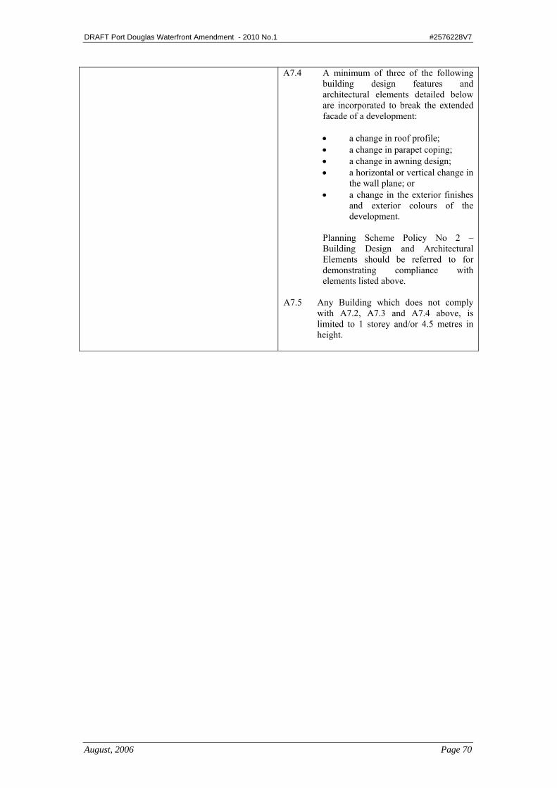
A7.4 A minimum of three of the following building design features and architectural elements detailed below are incorporated to break the extended facade of a development: • a change in roof profile; • a change in parapet coping; • a change in awning design; • a horizontal or vertical change in
the wall plane; or • a change in the exterior finishes
and exterior colours of the development.
Planning Scheme Policy No 2 – Building Design and Architectural Elements should be referred to for demonstrating compliance with elements listed above.
A7.5 Any Building which does not comply with A7.2, A7.3 and A7.4 above, is limited to 1 storey and/or 4.5 metres in height.
DRAFT Port Douglas Waterfront Amendment - 2010 No.1 #2576228V7
August, 2006 Page 71
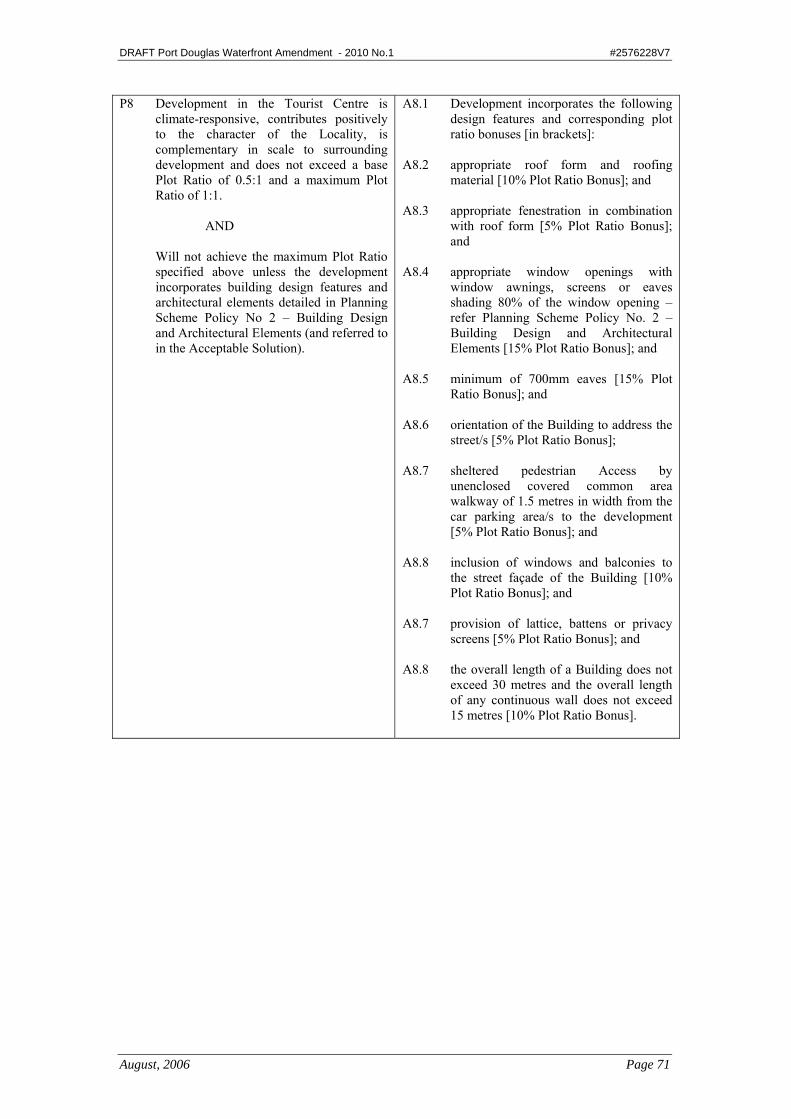
P8 Development in the Tourist Centre is climate-responsive, contributes positively to the character of the Locality, is complementary in scale to surrounding development and does not exceed a base Plot Ratio of 0.5:1 and a maximum Plot Ratio of 1:1.
AND
Will not achieve the maximum Plot Ratio specified above unless the development incorporates building design features and architectural elements detailed in Planning Scheme Policy No 2 – Building Design and Architectural Elements (and referred to in the Acceptable Solution).
A8.1 Development incorporates the following design features and corresponding plot ratio bonuses [in brackets]:
A8.2 appropriate roof form and roofing
material [10% Plot Ratio Bonus]; and A8.3 appropriate fenestration in combination
with roof form [5% Plot Ratio Bonus]; and
A8.4 appropriate window openings with
window awnings, screens or eaves shading 80% of the window opening – refer Planning Scheme Policy No. 2 – Building Design and Architectural Elements [15% Plot Ratio Bonus]; and
A8.5 minimum of 700mm eaves [15% Plot
Ratio Bonus]; and A8.6 orientation of the Building to address the
street/s [5% Plot Ratio Bonus]; A8.7 sheltered pedestrian Access by
unenclosed covered common area walkway of 1.5 metres in width from the car parking area/s to the development [5% Plot Ratio Bonus]; and
A8.8 inclusion of windows and balconies to
the street façade of the Building [10% Plot Ratio Bonus]; and
A8.7 provision of lattice, battens or privacy
screens [5% Plot Ratio Bonus]; and A8.8 the overall length of a Building does not
exceed 30 metres and the overall length of any continuous wall does not exceed 15 metres [10% Plot Ratio Bonus].
DRAFT Port Douglas Waterfront Amendment - 2010 No.1 #2576228V7
August, 2006 Page 72
P9 Car parking generated by:
a) the commercial component of development is fully or partly accommodated on the Site of the development, depending on the availability of alternative public car parking nearby with any balance to be paid in lieu of providing on-site car parking for commercial development in accordance with Planning Scheme Policy No 3 – Car Parking Contributions; and
b) the residential component of any
mixed use development is provided on the Site for the full allocation for units and visitor parking and is held in a common pool for common use.
A9.1 In respect to P9 (a), a minimum of 30% of the car parking requirements for the commercial component of development is provided on the Site of a development fronting Grant, Macrossan, Owen or Wharf Street, with 100% on-site provision applying for a commercial component along other streets in the Tourist Centre.
AND
Any balance is paid in lieu of providing
on-site car parking for commercial development in accordance with Planning Scheme Policy No. 3 – Car Parking Contributions.
P10 The use of on Site public car parking in the Tourist Centre is maximised.
A10.1 On Site car parking available for public use in the Tourist Centre is clearly sign-posted at the Site Frontage.
A10.2 Signage for car parking for public use is
to be of a standard blue and white sign with a directional arrow unless otherwise specified.
A10.3 Boom gates, pay machines or other
regulatory devices to control Access to public car parking areas are not constructed/erected.
P11 Car parking and access in the Tourist
Centre:
a) does not dominate street Frontages, especially along streets with high pedestrian traffic and pedestrian-oriented development; and
b) facilitates pedestrian connectivity; and c) is safe and convenient.
A11.1 In respect to P11 (a), along Grant, Macrossan, Owen and Wharf Streets, on-site car parking and Access is minimised, and where possible, shared access driveways and Access easements are to be provided to limit the number of vehicles crossings;

DRAFT Port Douglas Waterfront Amendment - 2010 No.1 #2576228V7
August, 2006 Page 73
P12 Residents in residential accommodation
located within the Tourist Centre are protected from noise intrusion associated with night time activities, such as outdoor dining, bars and nightclubs.
No Acceptable Solution. (Information that the Council may request to demonstrate compliance with the Performance Criteria is outlined in Planning Scheme Policy No 10 – Reports and Information the Council May Request, for code and impact assessable development).
P13 Safe and convenient pedestrian linkages are promoted in the Tourist Centre.
A13.1 One centrally located pedestrian Access is provided via a sheltered walkway/arcade from Macrossan Street to Warner Street between Grant Street and Owen Street.
Local Centres
PERFORMANCE CRITERIA ACCEPTABLE SOLUTIONS P14 Local Centres outside the Tourist Centre
service the surrounding residential area and do not adversely impact on the viability of the Tourist Centre.
A14.1 The Net Lettable Area of each of the existing Local Centres does not exceed 300 m2 and is apportioned equally between the total number of lots which comprise the Local Centre.
A14.2 Any proposed new Local Centre with a
maximum Net Lettable Area of 500 m2, only establishes when an identifiable population of 1000 persons is located more than 2 km from any existing Local Centre or the Tourist Centre.
A14.3 Any new Local Centre is located at a
“gateway” location to a residential area, which best serves the surrounding residential area.
DRAFT Port Douglas Waterfront Amendment - 2010 No.1 #2576228V7
August, 2006 Page 74
Residential Development Outside Tourist Centre
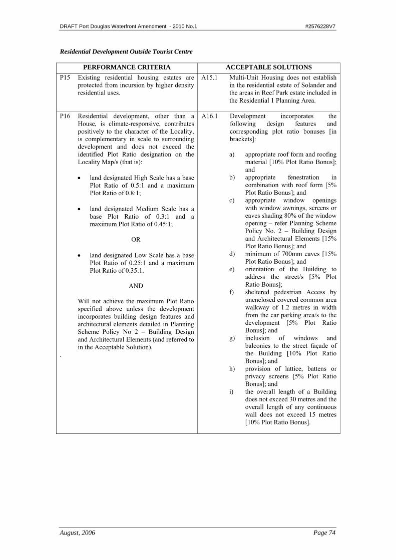
PERFORMANCE CRITERIA ACCEPTABLE SOLUTIONS P15 Existing residential housing estates are
protected from incursion by higher density residential uses.
A15.1 Multi-Unit Housing does not establish in the residential estate of Solander and the areas in Reef Park estate included in the Residential 1 Planning Area.
P16 Residential development, other than a
House, is climate-responsive, contributes positively to the character of the Locality, is complementary in scale to surrounding development and does not exceed the identified Plot Ratio designation on the Locality Map/s (that is):
• land designated High Scale has a base
Plot Ratio of 0.5:1 and a maximum Plot Ratio of 0.8:1;
• land designated Medium Scale has a
base Plot Ratio of 0.3:1 and a maximum Plot Ratio of 0.45:1;
OR
• land designated Low Scale has a base
Plot Ratio of 0.25:1 and a maximum Plot Ratio of 0.35:1.
AND
Will not achieve the maximum Plot Ratio specified above unless the development incorporates building design features and architectural elements detailed in Planning Scheme Policy No 2 – Building Design and Architectural Elements (and referred to in the Acceptable Solution).
.
A16.1 Development incorporates the following design features and corresponding plot ratio bonuses [in brackets]:
a) appropriate roof form and roofing
material [10% Plot Ratio Bonus]; and
b) appropriate fenestration in combination with roof form [5% Plot Ratio Bonus]; and
c) appropriate window openings with window awnings, screens or eaves shading 80% of the window opening – refer Planning Scheme Policy No. 2 – Building Design and Architectural Elements [15% Plot Ratio Bonus]; and
d) minimum of 700mm eaves [15% Plot Ratio Bonus]; and
e) orientation of the Building to address the street/s [5% Plot Ratio Bonus];
f) sheltered pedestrian Access by unenclosed covered common area walkway of 1.2 metres in width from the car parking area/s to the development [5% Plot Ratio Bonus]; and
g) inclusion of windows and balconies to the street façade of the Building [10% Plot Ratio Bonus]; and
h) provision of lattice, battens or privacy screens [5% Plot Ratio Bonus]; and
i) the overall length of a Building does not exceed 30 metres and the overall length of any continuous wall does not exceed 15 metres [10% Plot Ratio Bonus].
DRAFT Port Douglas Waterfront Amendment - 2010 No.1 #2576228V7
August, 2006 Page 75
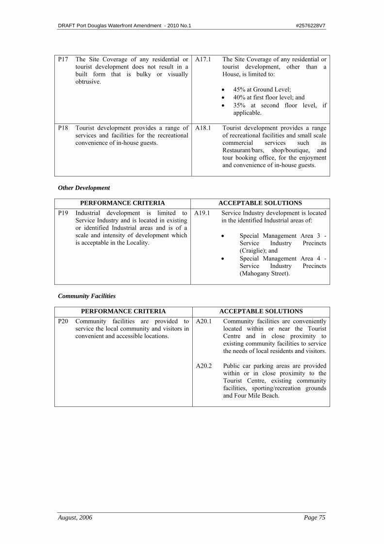
P17 The Site Coverage of any residential or
tourist development does not result in a built form that is bulky or visually obtrusive.
A17.1 The Site Coverage of any residential or tourist development, other than a House, is limited to:
• 45% at Ground Level; • 40% at first floor level; and • 35% at second floor level, if
applicable.
P18 Tourist development provides a range of services and facilities for the recreational convenience of in-house guests.
A18.1 Tourist development provides a range of recreational facilities and small scale commercial services such as Restaurant/bars, shop/boutique, and tour booking office, for the enjoyment and convenience of in-house guests.
Other Development
PERFORMANCE CRITERIA ACCEPTABLE SOLUTIONS P19 Industrial development is limited to
Service Industry and is located in existing or identified Industrial areas and is of a scale and intensity of development which is acceptable in the Locality.
A19.1 Service Industry development is located in the identified Industrial areas of: • Special Management Area 3 -
Service Industry Precincts (Craiglie); and
• Special Management Area 4 - Service Industry Precincts (Mahogany Street).
Community Facilities
PERFORMANCE CRITERIA ACCEPTABLE SOLUTIONS P20 Community facilities are provided to
service the local community and visitors in convenient and accessible locations.
A20.1 Community facilities are conveniently located within or near the Tourist Centre and in close proximity to existing community facilities to service the needs of local residents and visitors.
A20.2 Public car parking areas are provided
within or in close proximity to the Tourist Centre, existing community facilities, sporting/recreation grounds and Four Mile Beach.

DRAFT Port Douglas Waterfront Amendment - 2010 No.1 #2576228V7
August, 2006 Page 76
Protection of Scenic Amenity and Natural Values
PERFORMANCE CRITERIA ACCEPTABLE SOLUTIONS P21 The views and vistas of Four Mile Beach
from the intersection of Davidson Street and Macrossan Street to the beach front are maintained.
A21.1 Any development in Macrossan Street between Davidson Street and the beach front, outside the Tourist Centre, is designed with Macrossan Street as the Main Street Frontage and the Buildings are Setback 6 metres from the Main Street Frontage.
P22 Development does not adversely impact on
areas of sensitive natural vegetation, foreshore areas, Watercourses and areas of tidal inundation which contribute the Scenic Amenity and natural values of the locality2,3.
No Acceptable Solution. (Information that the Council may request to demonstrate compliance with the Performance Criteria is outlined in Planning Scheme Policy No 10 – Reports and Information the Council May Request, for code and impact assessable development).
Port Douglas Waterfront
PERFORMANCE CRITERIA ACCEPTABLE SOLUTIONS P23 The Port Douglas Waterfront is protected
from any new incompatible land uses and activities or intensification of existing incompatible uses, to allow for future planned spatial arrangements of the waterfront.
A23.1 Development in the Port Douglas Waterfront North Planning Area and the Port Douglas Waterfront South Planning Area complies with the respective Codes for each Planning Area; and
A23.2 Development in the Commercial
Planning Area on premises in that has road frontages on both Warner Street and the unnamed laneway at the rear, use Warner Street as the Primary Road frontage for pedestrian access and business frontage ensuring centralised parking on Lot 12 on SR787 for the Port Douglas Waterfront and Tourist Centre is unimpeded.
2 The Environmental Protection Agency is a Concurrence Agency for assessable development within a Coastal Management District. 3 Vegetation clearing is required to be undertaken in accordance with Local Law – Vegetation Management.
DRAFT Port Douglas Waterfront Amendment - 2010 No.1 #2576228V7
August, 2006 Page 77
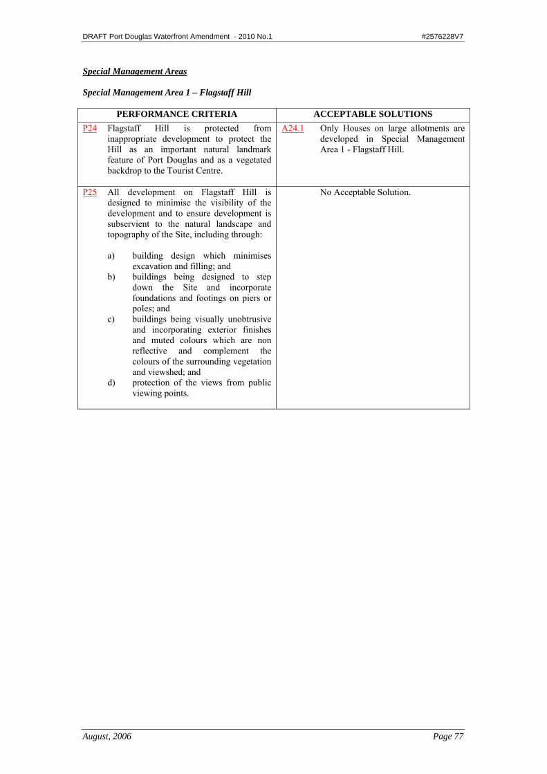
Special Management Areas Special Management Area 1 – Flagstaff Hill
PERFORMANCE CRITERIA ACCEPTABLE SOLUTIONS P24 Flagstaff Hill is protected from
inappropriate development to protect the Hill as an important natural landmark feature of Port Douglas and as a vegetated backdrop to the Tourist Centre.
A24.1 Only Houses on large allotments are developed in Special Management Area 1 - Flagstaff Hill.
P25 All development on Flagstaff Hill is designed to minimise the visibility of the development and to ensure development is subservient to the natural landscape and topography of the Site, including through:
a) building design which minimises
excavation and filling; and b) buildings being designed to step
down the Site and incorporate foundations and footings on piers or poles; and
c) buildings being visually unobtrusive and incorporating exterior finishes and muted colours which are non reflective and complement the colours of the surrounding vegetation and viewshed; and
d) protection of the views from public viewing points.
No Acceptable Solution.
DRAFT Port Douglas Waterfront Amendment - 2010 No.1 #2576228V7
August, 2006 Page 78
Special Management Area 2 – Residential Growth Area
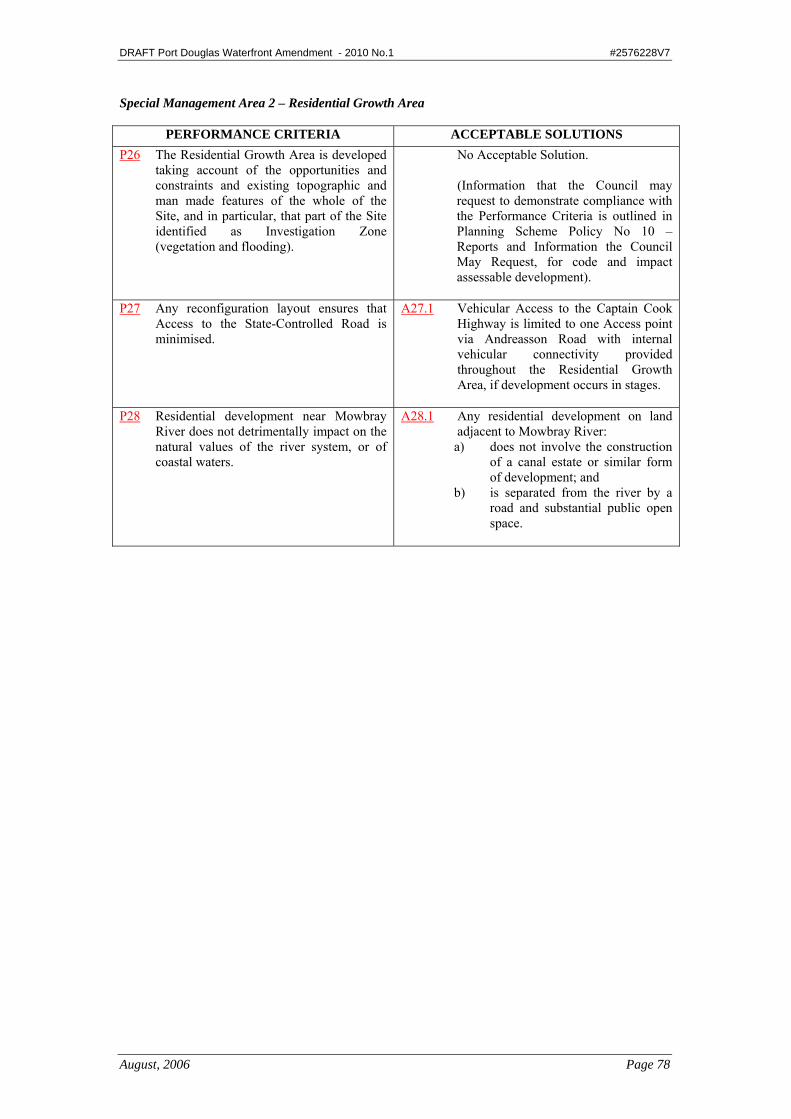
PERFORMANCE CRITERIA ACCEPTABLE SOLUTIONS P26 The Residential Growth Area is developed
taking account of the opportunities and constraints and existing topographic and man made features of the whole of the Site, and in particular, that part of the Site identified as Investigation Zone (vegetation and flooding).
No Acceptable Solution. (Information that the Council may request to demonstrate compliance with the Performance Criteria is outlined in Planning Scheme Policy No 10 – Reports and Information the Council May Request, for code and impact assessable development).
P27 Any reconfiguration layout ensures that Access to the State-Controlled Road is minimised.
A27.1 Vehicular Access to the Captain Cook Highway is limited to one Access point via Andreasson Road with internal vehicular connectivity provided throughout the Residential Growth Area, if development occurs in stages.
P28 Residential development near Mowbray
River does not detrimentally impact on the natural values of the river system, or of coastal waters.
A28.1 Any residential development on land adjacent to Mowbray River: a) does not involve the construction
of a canal estate or similar form of development; and
b) is separated from the river by a road and substantial public open space.

DRAFT Port Douglas Waterfront Amendment - 2010 No.1 #2576228V7
August, 2006 Page 79
Special Management Area 3 – Service Industry Precincts (Craiglie)
PERFORMANCE CRITERIA ACCEPTABLE SOLUTIONS P29 Development within the Craiglie Service
Industry Precinct supports the tourism and marine industries within Port Douglas.
A29.1 Only Service Industry uses are located in the Service Industry Precincts (Craiglie).
AND The proponent of the proposed Service Industry use provides written evidence to Council that it supports/services the tourism or marine industry in Port Douglas.
P30 Development on lots adjacent to the Captain Cook Highway is sited, designed and landscaped to provides an attractive visual approach to Port Douglas with all buildings, structures and carparking areas setback a sufficient distance from the Frontage to enable landscaping to screen or soften the appearance of the development.
A30.1 Buildings and structures are setback 8 metres from the Captain Cook Highway Frontage, or no closer to the Captain Cook Highway Frontage than buildings and structures on adjoining Sites (averaged), which ever is the greater.
A30.2 The Setback area to the Captain Cook
Highway Frontage is landscaped with advanced Dense Planting including trees species (100 litre bag stock), which will, at maturity, exceed the Height of the Building on Site.
A30.3 Advertising signs are discreet in
appearance with no large advertising signs including tenancy signs located on or near the Captain Cook Highway Frontage, or within any landscaped setback area adjacent to the highway.
A30.4 Car parking areas, loading and other
service areas are designed to be screened from the Captain Cook Highway and are located so as not to be visually prominent from the Captain Cook Highway.

DRAFT Port Douglas Waterfront Amendment - 2010 No.1 #2576228V7
August, 2006 Page 80
P31 The reconfiguration of Lot 83 on SR 724 for Industrial development proceeds in line with a demonstrated demand for industrial land at Craiglie
A31.1 Council will only support the staged reconfiguration of that part of Lot 83 on SR 724 designated in the Industry Planning Area, in association with a Needs Analysis, prepared in accordance with Planning Scheme Policy No 10 – Reports and Information the Council May Request, which demonstrates a clear demand for additional industrial land at Craiglie.
A31.2 The Needs Analysis incorporates a
methodology to be approved by Council for the staged development of any reconfiguration of the land for industrial purposes, in line with a specified future demand scenario.
A31.3 The reconfiguration and/or
redesignation for industrial development of that part of Lot 83 on SR 724 included in the Rural Planning Area does not occur in the life of this Planning Scheme, unless supported by another Needs Analysis prepared in accordance with A29.1 and A29.2 above.
P32 The parkland contribution associated with
the reconfiguration of Lot 83 on SR 724 provides for the expansion of Teamster Park.
A32.1 Provision shall be made for a park contribution associated with the reconfiguration of Lot 83 on SR 724. Should the park contribution be provided in stages, the total contribution of land must be identified in one area in association with Stage 1 of any reconfiguration application.
P33 Development on the western side of Owen
Street provides for a range of Service Industry uses, which may incorporate a minor, ancillary and necessarily associated retail component.
A33.1 Service Industry development on the western side of Owen Street can be designed to designate up to a maximum of 30% of the total Gross Floor Area of any Building/s on the Site for a retail component to be located at the front of the development, provided the retail component is allied to the primary Service Industry activity carried out on the Site.
DRAFT Port Douglas Waterfront Amendment - 2010 No.1 #2576228V7
August, 2006 Page 81
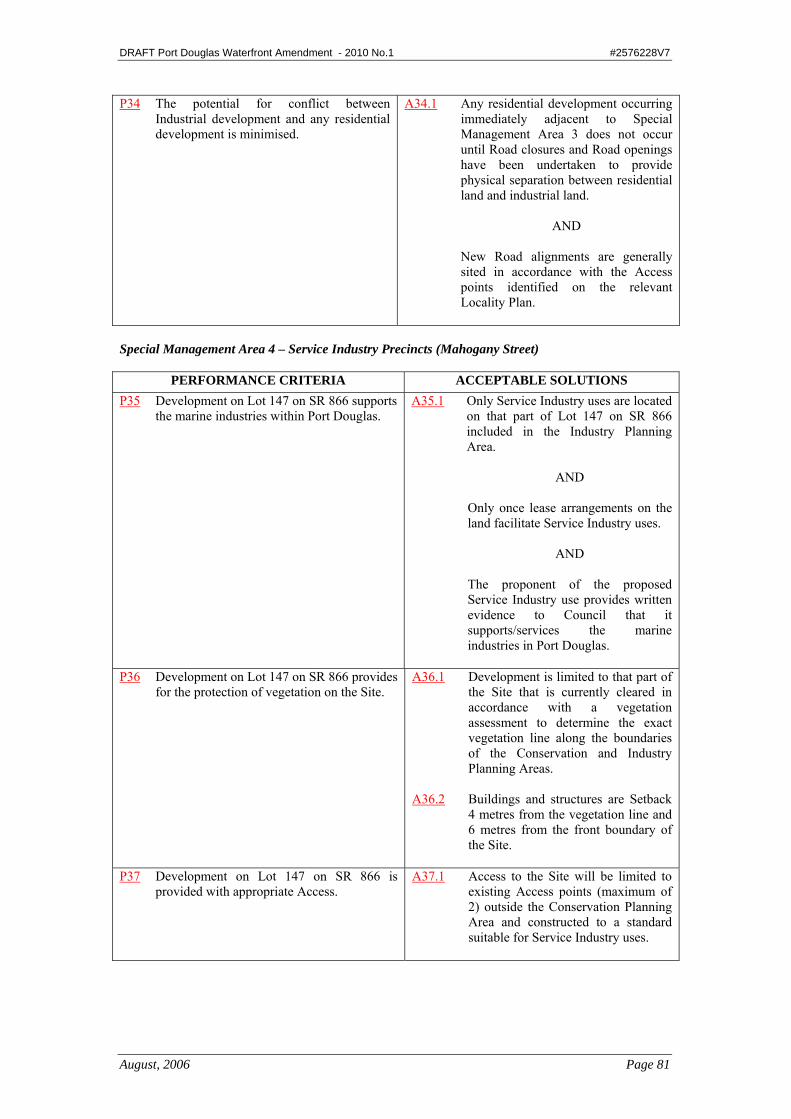
P34 The potential for conflict between Industrial development and any residential development is minimised.
A34.1 Any residential development occurring immediately adjacent to Special Management Area 3 does not occur until Road closures and Road openings have been undertaken to provide physical separation between residential land and industrial land.
AND
New Road alignments are generally sited in accordance with the Access points identified on the relevant Locality Plan.
Special Management Area 4 – Service Industry Precincts (Mahogany Street)
PERFORMANCE CRITERIA ACCEPTABLE SOLUTIONS P35 Development on Lot 147 on SR 866 supports
the marine industries within Port Douglas. A35.1 Only Service Industry uses are located
on that part of Lot 147 on SR 866 included in the Industry Planning Area.
AND Only once lease arrangements on the land facilitate Service Industry uses.
AND The proponent of the proposed Service Industry use provides written evidence to Council that it supports/services the marine industries in Port Douglas.
P36 Development on Lot 147 on SR 866 provides for the protection of vegetation on the Site.
A36.1 Development is limited to that part of the Site that is currently cleared in accordance with a vegetation assessment to determine the exact vegetation line along the boundaries of the Conservation and Industry Planning Areas.
A36.2 Buildings and structures are Setback
4 metres from the vegetation line and 6 metres from the front boundary of the Site.
P37 Development on Lot 147 on SR 866 is
provided with appropriate Access. A37.1 Access to the Site will be limited to
existing Access points (maximum of 2) outside the Conservation Planning Area and constructed to a standard suitable for Service Industry uses.

DRAFT Port Douglas Waterfront Amendment - 2010 No.1 #2576228V7
August, 2006 Page 82
Special Management Area 5 – Waterfront Investigation Area Precinct
PERFORMANCE CRITERIA ACCEPTABLE SOLUTIONS • The Waterfront Precinct is
protected from any new incompatible land uses and activities or intensification of existing incompatible uses, to allow for future planned spatial arrangements of the waterfront including marine-based industry, maritime infrastructure, tourist/commercial, marina, and community and recreation activities.
No Acceptable Solution. (Information that the Council may request to demonstrate compliance with the Performance Criteria is outlined in Planning Scheme Policy No 11 –Port Douglas Waterfront Integrated Development Plan, for code and impact assessable development).
DRAFT Port Douglas Waterfront Amendment - 2010 No.1 #2576228V7
August, 2006 Page 157
4.3.10 Port Douglas Waterfront North Planning Area Code Purpose The purpose of this Code is to facilitate the achievement of the following desired development outcomes for the Port Douglas Waterfront North Planning Area: • The Port Douglas Waterfront North Planning Area evolves as revitalised open
space and waterside development precinct; • Development within the Port Douglas Waterfront North Planning Area is designed
to be sympathetic to the environmentally sensitive Dickson Inlet and mitigates any adverse impacts;
• The establishment of mixed-use development is facilitated to promote activity and vitality;
• Development contributes to a high quality public realm; • Built form provides an attractive point of arrival from both land and sea; • Pedestrian connectivity is safe, efficient and provides for the needs of all users of
the Port Douglas Waterfront; • Parking (and associated infrastructure) does not undermine the relationship between
buildings and street; • A sense of place is created through aesthetic streetscapes and innovative public and
private open space; • Character is enhanced through the identification of gateway sites, landmarks, main
approach routes and pedestrian thoroughfares and view corridors; • A high level of pedestrian and streetscape amenity is facilitated along the waterfront
and road network through the use of landscaping, public art and streetscape elements;
• The importance of marine-based industries to the area is recognised; • Marine-based industries are protected from incompatible uses; • Marine infrastructure is established to service the tourism, fishing and private
boating community; • The functionality of the Balley Hooley tourist rail is retained; • Uses identified as inconsistent uses in the Assessment Table dealing with material
change of use for the Port Douglas & Environs Locality are not established in the Port Douglas Waterfront North Planning Area.
Applicability This Code applies to self assessable and assessable development in the Port Douglas Waterfront North Planning Area for: • Material Change of Use:
Except for: - Shopping Facilities, Business Facilities or Restaurant – using an existing
Building • Reconfiguring a Lot; • Operational Work Associated with Reconfiguring a Lot;
DRAFT Port Douglas Waterfront Amendment - 2010 No.1 #2576228V7
August, 2006 Page 158
• Operational Work – Filling or Excavation not associated with a Material Change of Use;
• Operational Work – Engineering Works not associated with a Material Change of Use;
• Operational Work – Placing an Advertising Device on Premises not associated with a Material Change of Use;
•Operational Work – Prescribed Tidal Work; and • Building Work other than Minor Building Work not associated with a Material
Change of Use. For self-assessable development assessed against this Code, the applicable Acceptable Solutions are A1.1 and A2.1. Self assessable development which does not comply with Acceptable Solutions as listed above, outlined in this Code will require Code Assessment. Elements of the Code Consistent and Inconsistent Uses PERFORMANCE CRITERIA ACCEPTABLE SOLUTIONS P1 The establishment of uses is consistent with the
outcomes sought for the Port Douglas Waterfront South Planning Area.
A1.1 Uses identified as inconsistent uses in the Assessment Table are not established in the Waterfront South Planning Area.
Design, Layout and Built Form
PERFORMANCE CRITERIA ACCEPTABLE SOLUTIONS P2 The bulk and scale of buildings is consistent with
surrounding development and steps down to compliment the open space areas in the northern parts of the Port Douglas Waterfront..
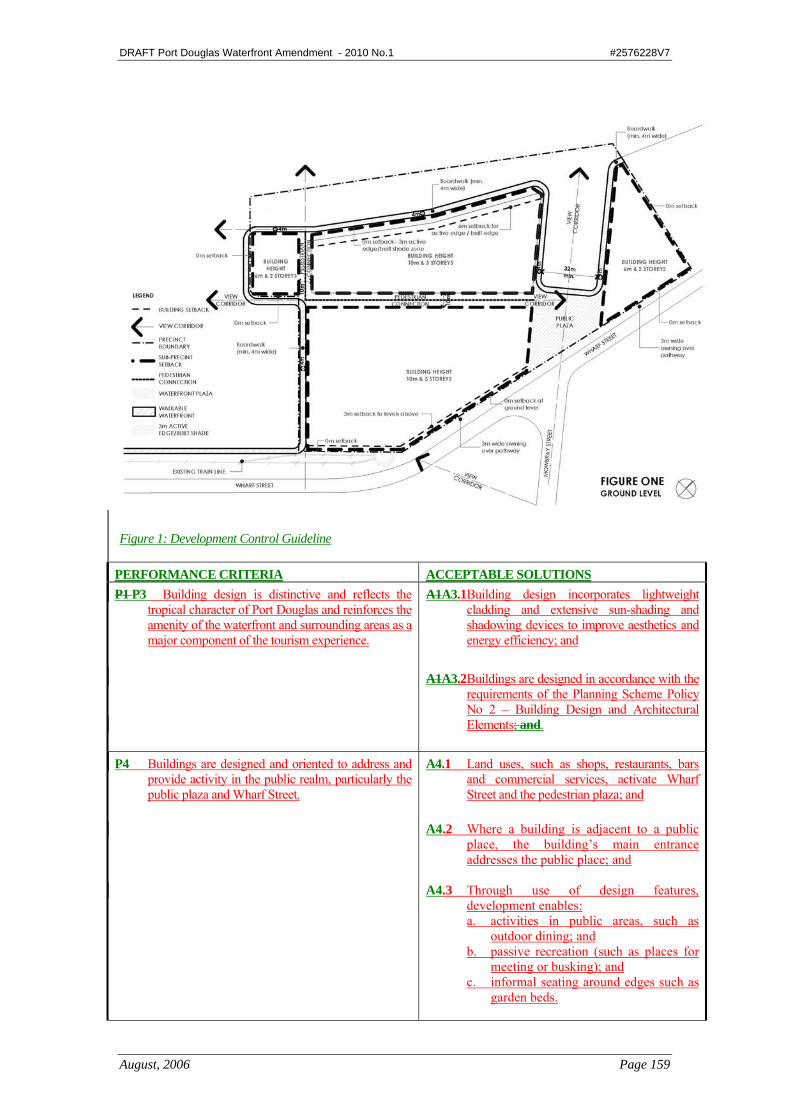
A2.1 Development is designed in accordance with the control guidelines shown in Figure 1. Setbacks and building envelopes will be generally in accordance with those specified in this figure.
DRAFT Port Douglas Waterfront Amendment - 2010 No.1 #2576228V7
August, 2006 Page 159
Figure 1: Development Control Guideline
PERFORMANCE CRITERIA ACCEPTABLE SOLUTIONS P1 P3 Building design is distinctive and reflects the
tropical character of Port Douglas and reinforces the amenity of the waterfront and surrounding areas as a major component of the tourism experience.
A1A3.1 Building design incorporates lightweight cladding and extensive sun-shading and shadowing devices to improve aesthetics and energy efficiency; and
A1A3.2 Buildings are designed in accordance with the
requirements of the Planning Scheme Policy No 2 – Building Design and Architectural Elements; and.
P4 Buildings are designed and oriented to address and
provide activity in the public realm, particularly the public plaza and Wharf Street.
A4.1 Land uses, such as shops, restaurants, bars and commercial services, activate Wharf Street and the pedestrian plaza; and
A4.2 Where a building is adjacent to a public
place, the building’s main entrance addresses the public place; and
A4.3 Through use of design features,
development enables: a. activities in public areas, such as
outdoor dining; and b. passive recreation (such as places for
meeting or busking); and c. informal seating around edges such as
garden beds.
DRAFT Port Douglas Waterfront Amendment - 2010 No.1 #2576228V7
August, 2006 Page 160
PERFORMANCE CRITERIA ACCEPTABLE SOLUTIONS P4P5 The design of buildings ensures that:
a. the streetscape is cohesive; and b. pedestrians are afforded protection from the
sun and from rain; and c. development allows for on-site landscaping
and street trees for an attractive and tropical streetscape.
A4A5.1 A non-transparent cantilevered awning is provided for the full length of the road frontage/s of buildings with a zero metre setback, as generally depicted in Figure 1. Posts may be included in the awnings design however these are to be non load bearing; and
A4A5.2 The underside of the awning is a
minimum of 3 metres and a maximum of 4 metres above the finished level of the footpath; and
A4A5.3 The design of the awning allows for street
tree plantings; and A4A5.4 Dense landscaping is provided adjacent to
the road frontage where buildings are not built to the front boundary.
Retention of Balley Hooley Rail Line
PERFORMANCE CRITERIA ACCEPTABLE SOLUTIONS P5P6 The Bally Hooley rail line and turn-table is retained
and incorporated in development to maintain its functionality.
A5A6.1 No Acceptable Solutions Specified.
Mitigating Adverse Impacts PERFORMANCE CRITERIA ACCEPTABLE SOLUTIONS P6 P7 Development mitigates the adverse impacts of
flood, storm tide inundation and sea level rise. A6A7.1 Floors that provide tourist or permanent
accommodation are located above the Storm Tide Inundation Area and consider rising sea levels; and
A6A7.2 Floors for new commercial and retail uses are
located 150mm above the 1 in 100 year ARI flood event; or
A6A7.3 Additions to existing buildings may use
existing floor levels only where it is necessary to retain functionality of the building’s use.

DRAFT Port Douglas Waterfront Amendment - 2010 No.1 #2576228V7
August, 2006 Page 161
PERFORMANCE CRITERIA ACCEPTABLE SOLUTIONS P7 P8 Development recognises the importance of and
relationship between the marina, commercial and residential development in the Port Douglas Waterfront Planning Area, and includes measures to mitigate the impact of: a. noise; and b. odour; and c. hazardous materials; and d. aesthetics.
A7A8.1 Development incorporates buildings, structures and landscaped areas that can serve as a buffer between residential and non-residential use areas; and
A7A8.2 Service and rubbish collection points:
a. are positioned to minimise conflict with residential accommodation; and
b. include measures to mitigate adverse noises and smells; and
c. minimise the need for trucks to use their reversing horns.
A7A8.3 Service structures and mechanical plant are is
not visible from: a. the street; and b. adjoining properties; and c. Public open space; and
A7A8.4 Service structures and mechanical plant is not
located away from: a. on balconies or adjacent to other
liveable areas; and b. Near multiple reflective surfaces such
as walls and eaves; and A7A8.5 Potential noise impacts are mitigated through
the use of: a. sound insulation; and b. sensitive internal planning; and c. acoustic barriers between residential
and non-residential uses; and A7A8.6 Hazardous Materials are stored in an
enclosed, bunded area, away from residential uses.
Sustainable Building Design
PERFORMANCE CRITERIA ACCEPTABLE SOLUTIONS P8P9 New buildings: a. promote exemplary environmentally
sustainable building design outcomes.; and b. incorporate features that minimise energy
and water use, and maximise the efficiency of land use and infrastructure; and
c. include high performance building fabrics, cross ventilation , wide eaves and overhangs, shade devices, natural ventilation.
A8A9.1 No Acceptable Solutions Specified.
DRAFT Port Douglas Waterfront Amendment - 2010 No.1 #2576228V7
August, 2006 Page 162
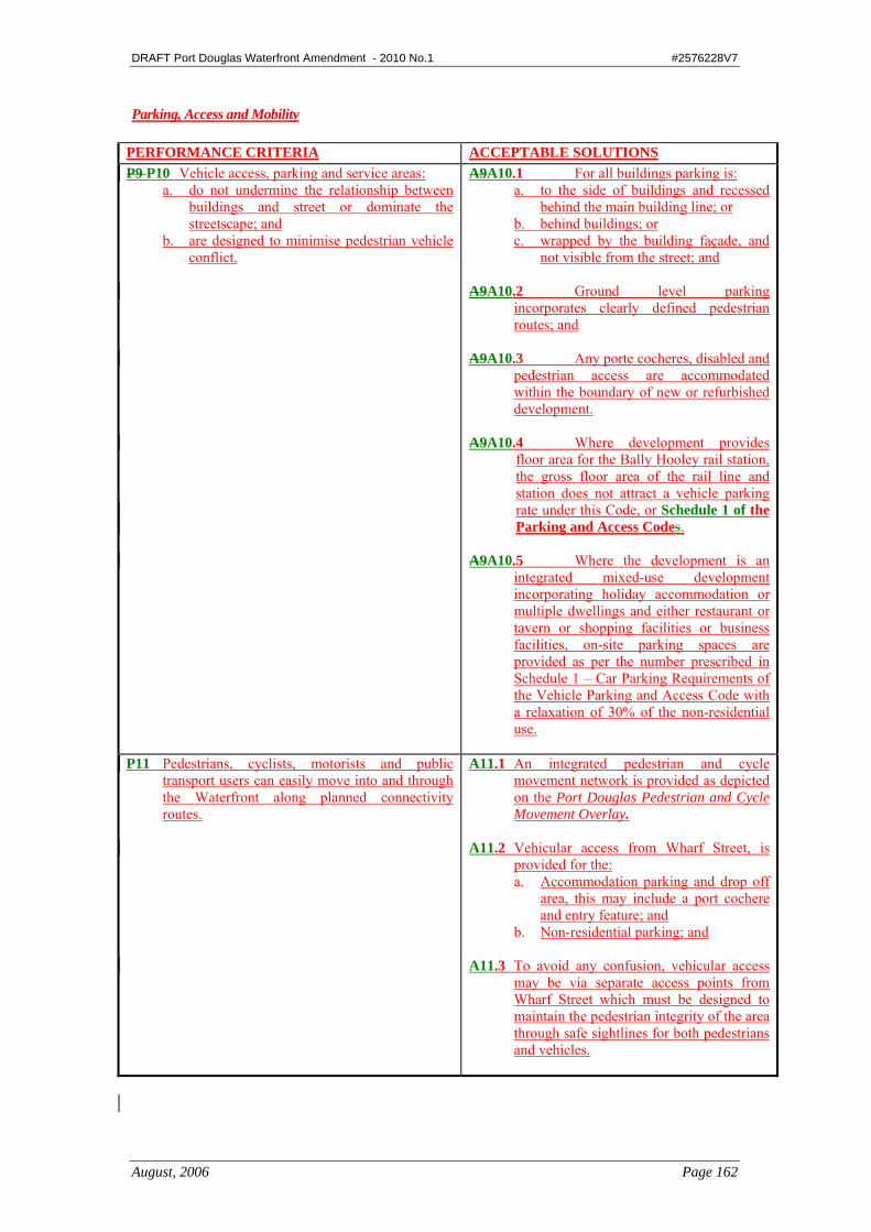
Parking, Access and Mobility
PERFORMANCE CRITERIA ACCEPTABLE SOLUTIONS P9 P10 Vehicle access, parking and service areas:
a. do not undermine the relationship between buildings and street or dominate the streetscape; and
b. are designed to minimise pedestrian vehicle conflict.
A9A10.1 For all buildings parking is: a. to the side of buildings and recessed
behind the main building line; or b. behind buildings; or c. wrapped by the building façade, and
not visible from the street; and A9A10.2 Ground level parking
incorporates clearly defined pedestrian routes; and
A9A10.3 Any porte cocheres, disabled and
pedestrian access are accommodated within the boundary of new or refurbished development.
A9A10.4 Where development provides
floor area for the Bally Hooley rail station, the gross floor area of the rail line and station does not attract a vehicle parking rate under this Code, or Schedule 1 of the Parking and Access Codes.
A9A10.5 Where the development is an
integrated mixed-use development incorporating holiday accommodation or multiple dwellings and either restaurant or tavern or shopping facilities or business facilities, on-site parking spaces are provided as per the number prescribed in Schedule 1 – Car Parking Requirements of the Vehicle Parking and Access Code with a relaxation of 30% of the non-residential use.
P11 Pedestrians, cyclists, motorists and public
transport users can easily move into and through the Waterfront along planned connectivity routes.
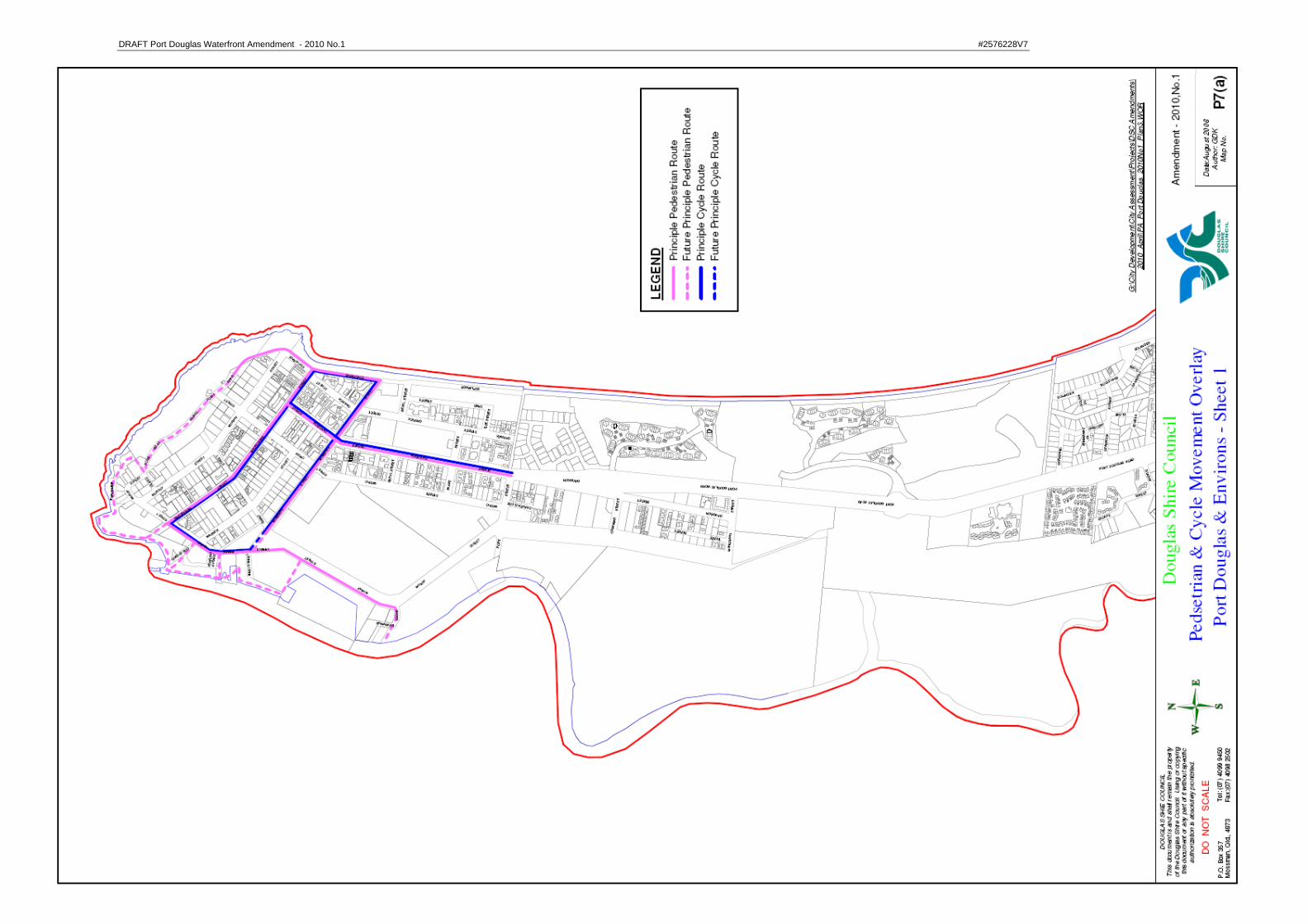
A11.1 An integrated pedestrian and cycle movement network is provided as depicted on the Port Douglas Pedestrian and Cycle Movement Overlay.
A11.2 Vehicular access from Wharf Street, is
provided for the: a. Accommodation parking and drop off
area, this may include a port cochere and entry feature; and
b. Non-residential parking; and A11.3 To avoid any confusion, vehicular access
may be via separate access points from Wharf Street which must be designed to maintain the pedestrian integrity of the area through safe sightlines for both pedestrians and vehicles.
DRAFT Port Douglas Waterfront Amendment - 2010 No.1 #2576228V7
August, 2006 Page 163
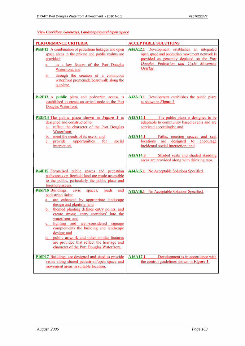
View Corridors, Gateways, Landscaping and Open Space
PERFORMANCE CRITERIA ACCEPTABLE SOLUTIONS P11P12 A combination of pedestrian linkages and open
space areas in the private and public realms are provided: a. as a key feature of the Port Douglas
Waterfront; and b. through the creation of a continuous
waterfront promenade/boardwalk along the quayline.
A11A12.1 Development establishes an integrated open space and pedestrian movement network is provided as generally depicted on the Port Douglas Pedestrian and Cycle Movement Overlay.
P12P13 A public plaza and pedestrian access is established to create an arrival node to the Port Douglas Waterfront.
A12A13.1 Development establishes the public plaza as shown in Figure 1.
P13P14 The public plaza shown in Figure 1 is designed and constructed to: a. reflect the character of the Port Douglas
Waterfront; b. meet the needs of its users; and c. provide opportunities for social
interaction.
A13A14.1 The public plaza is designed to be adaptable to community based events and are serviced accordingly; and
A13A14.1 Paths, meeting spaces and seat
locations are designed to encourage incidental social interaction; and
A13A14.3 Shaded seats and shaded standing
areas are provided along with drinking taps.
P14P15 Formalised public spaces and pedestrian paths/areas on freehold land are made accessible to the public, particularly the public plaza and foreshore access.
A14A15.1 No Acceptable Solutions Specified.
P15P16 Buildings, civic spaces, roads and pedestrian links: a. are enhanced by appropriate landscape
design and planting; and b. themed planting defines entry points, and
create strong ‘entry corridors’ into the waterfront; and
c. lighting and well-considered signage complements the building and landscape design; and
d. public artwork and other similar features are provided that reflect the heritage and character of the Port Douglas Waterfront.
A15A16.1 No Acceptable Solutions Specified.
P16P17 Buildings are designed and sited to provide vistas along shared pedestrian/open space and movement areas in suitable location.
A16A17.1 Development is in accordance with the control guidelines shown in Figure 1.

DRAFT Port Douglas Waterfront Amendment - 2010 No.1 #2576228V7
August, 2006 Page 164
Marine-Based Industry and Marine Infrastructure
PERFORMANCE CRITERIA ACCEPTABLE SOLUTIONS P17P18 Development does not diminish the viability of
marine-based industrial uses that directly serve the Port Douglas tourist and fishing operators and private boat owners, particularly with respect to the slipway operation.
A17A18.1 The Slipway is retained until such time as the capacity of the existing slipway is established in the Port Douglas Waterfront South Planning Area, or as otherwise approved by Council; and
A17A18.2 Buildings are designed to minimise conflict
between tourist and pedestrian areas and continued marine-based industrial activities.
P18P19 Marine infrastructure is established to service
the tourism, fishing and private boating community.
A18A19.1 No Acceptable Solutions Specified.
P19P20 Changes to the Port Douglas Waterfront quayline does not cause adverse impacts to the environmentally sensitive Dickson Inlet.
A19A20.1 Development that results in changes to the Port Douglas Waterfront quayline are only established where an Ecological Assessment Report provides support to the changes.
Note: Information that the Council may request to demonstrate compliance with the Performance Criteria is outlined in Planning Scheme Policy No 10 – Reports and Information the Council May Request, with particular reference to the requirements of an Ecological Assessment Report
DRAFT Port Douglas Waterfront Amendment - 2010 No.1 #2576228V7
August, 2006 Page 165
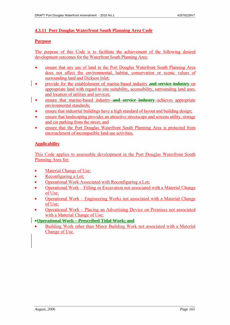
4.3.11 Port Douglas Waterfront South Planning Area Code Purpose The purpose of this Code is to facilitate the achievement of the following desired development outcomes for the Waterfront South Planning Area:
• ensure that any use of land in the Port Douglas Waterfront South Planning Area does not affect the environmental, habitat, conservation or scenic values of surrounding land and Dickson Inlet;
• provide for the establishment of marine-based industry and service industry on appropriate land with regard to site suitability, accessibility, surrounding land uses, and location of utilities and services;
• ensure that marine-based industry and service industry achieves appropriate environmental standards;
• ensure that industrial buildings have a high standard of layout and building design; • ensure that landscaping provides an attractive streetscape and screens utility, storage
and car parking from the street; and • ensure that the Port Douglas Waterfront South Planning Area is protected from
encroachment of incompatible land use activities. Applicability This Code applies to assessable development in the Port Douglas Waterfront South Planning Area for: • Material Change of Use: • Reconfiguring a Lot; • Operational Work Associated with Reconfiguring a Lot; • Operational Work – Filling or Excavation not associated with a Material Change
of Use; • Operational Work – Engineering Works not associated with a Material Change
of Use; • Operational Work – Placing an Advertising Device on Premises not associated
with a Material Change of Use; •Operational Work – Prescribed Tidal Work; and • Building Work other than Minor Building Work not associated with a Material
Change of Use.
DRAFT Port Douglas Waterfront Amendment - 2010 No.1 #2576228V7
August, 2006 Page 166
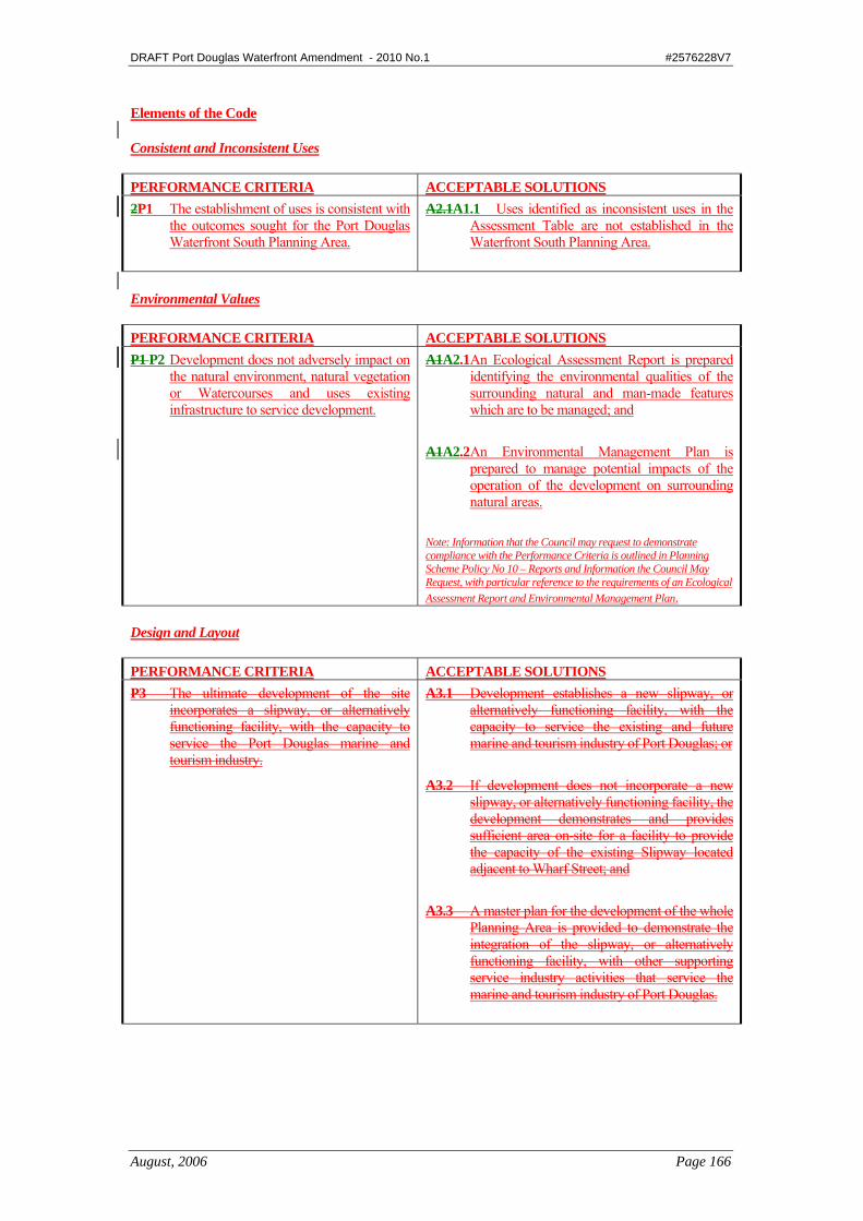
Elements of the Code Consistent and Inconsistent Uses PERFORMANCE CRITERIA ACCEPTABLE SOLUTIONS 2P1 The establishment of uses is consistent with
the outcomes sought for the Port Douglas Waterfront South Planning Area.
A2.1A1.1 Uses identified as inconsistent uses in the Assessment Table are not established in the Waterfront South Planning Area.
Environmental Values PERFORMANCE CRITERIA ACCEPTABLE SOLUTIONS P1 P2 Development does not adversely impact on
the natural environment, natural vegetation or Watercourses and uses existing infrastructure to service development.
A1A2.1 An Ecological Assessment Report is prepared identifying the environmental qualities of the surrounding natural and man-made features which are to be managed; and
A1A2.2 An Environmental Management Plan is
prepared to manage potential impacts of the operation of the development on surrounding natural areas.
Note: Information that the Council may request to demonstrate compliance with the Performance Criteria is outlined in Planning Scheme Policy No 10 – Reports and Information the Council May Request, with particular reference to the requirements of an Ecological Assessment Report and Environmental Management Plan.
Design and Layout PERFORMANCE CRITERIA ACCEPTABLE SOLUTIONS P3 The ultimate development of the site
incorporates a slipway, or alternatively functioning facility, with the capacity to service the Port Douglas marine and tourism industry.
A3.1 Development establishes a new slipway, or alternatively functioning facility, with the capacity to service the existing and future marine and tourism industry of Port Douglas; or
A3.2 If development does not incorporate a new
slipway, or alternatively functioning facility, the development demonstrates and provides sufficient area on-site for a facility to provide the capacity of the existing Slipway located adjacent to Wharf Street; and
A3.3 A master plan for the development of the whole
Planning Area is provided to demonstrate the integration of the slipway, or alternatively functioning facility, with other supporting service industry activities that service the marine and tourism industry of Port Douglas.

DRAFT Port Douglas Waterfront Amendment - 2010 No.1 #2576228V7
August, 2006 Page 167
PERFORMANCE CRITERIA ACCEPTABLE solutions P3 Development of land at the end of Port
Street adjacent to Dickson Inlet shown in Figure 1 incorporates a slipway, or alternatively functioning facility, with capacity to service the Port Douglas marine and tourism industry.
Figure 1
A3.1 Development of land at the end of Port Street adjacent to Dickson Inlet shown in Figure 1 incorporates a slipway, or alternatively functioning facility, with capacity to service the Port Douglas marine and tourism industry; or
A3.2 If development of land at the end of Port
Street adjacent to Dickson Inlet shown in Figure 1 incorporates a slipway, or alternatively functioning facility, the development demonstrates and provides sufficient area on-site for a facility to provide the capacity of the existing Slipway located adjacent to Wharf Street; and
A3.3 A master plan for the development of the
whole land shown in Figure 1 is provided to demonstrate the integration of the slipway, or alternatively functioning facility, with other supporting service industry activities that service the marine and tourism industry of Port Douglas.
P4 Buildings and structures are set back from
side boundaries and other sensitive areas such that the scenic amenity and environmental qualities of the adjacent area are not adversely affected
A4.1 No Acceptable Solutions Specified.
Site Coverage PERFORMANCE CRITERIA ACCEPTABLE SOLUTIONS P5 The site coverage of all Buildings ensures
development: a. is sited in an existing cleared area or in
an area approved for clearing; and b. has sufficient area for the provision of
services; and c. development does not have an adverse
effect on the environmental, habitat, conservation or scenic values of the sensitive, adjacent areas.
A5.1 No Acceptable Solutions Specified.
DRAFT Port Douglas Waterfront Amendment - 2010 No.1 #2576228V7
August, 2006 Page 168
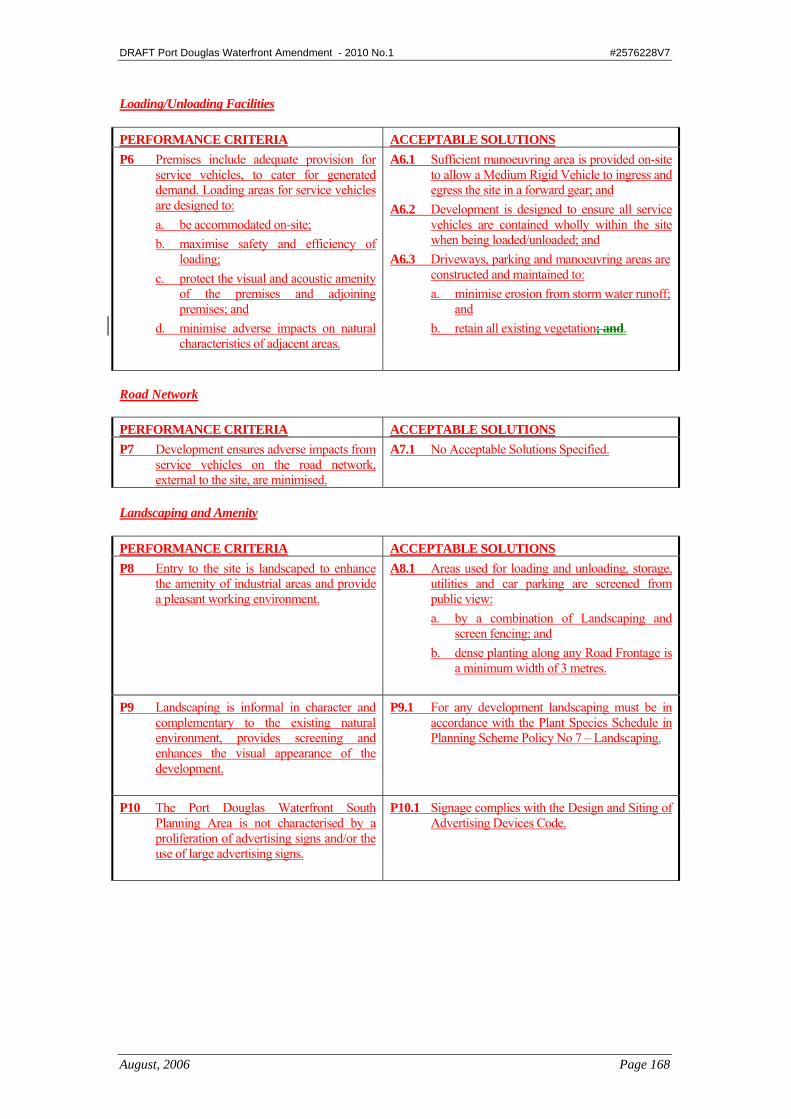
Loading/Unloading Facilities PERFORMANCE CRITERIA ACCEPTABLE SOLUTIONS P6 Premises include adequate provision for
service vehicles, to cater for generated demand. Loading areas for service vehicles are designed to: a. be accommodated on-site; b. maximise safety and efficiency of
loading; c. protect the visual and acoustic amenity
of the premises and adjoining premises; and
d. minimise adverse impacts on natural characteristics of adjacent areas.
A6.1 Sufficient manoeuvring area is provided on-site to allow a Medium Rigid Vehicle to ingress and egress the site in a forward gear; and
A6.2 Development is designed to ensure all service vehicles are contained wholly within the site when being loaded/unloaded; and
A6.3 Driveways, parking and manoeuvring areas are constructed and maintained to: a. minimise erosion from storm water runoff;
and b. retain all existing vegetation; and.
Road Network PERFORMANCE CRITERIA ACCEPTABLE SOLUTIONS P7 Development ensures adverse impacts from
service vehicles on the road network, external to the site, are minimised.
A7.1 No Acceptable Solutions Specified.
Landscaping and Amenity PERFORMANCE CRITERIA ACCEPTABLE SOLUTIONS P8 Entry to the site is landscaped to enhance
the amenity of industrial areas and provide a pleasant working environment.
A8.1 Areas used for loading and unloading, storage, utilities and car parking are screened from public view: a. by a combination of Landscaping and
screen fencing; and b. dense planting along any Road Frontage is
a minimum width of 3 metres.
P9 Landscaping is informal in character and complementary to the existing natural environment, provides screening and enhances the visual appearance of the development.
P9.1 For any development landscaping must be in accordance with the Plant Species Schedule in Planning Scheme Policy No 7 – Landscaping.
P10 The Port Douglas Waterfront South Planning Area is not characterised by a proliferation of advertising signs and/or the use of large advertising signs.
P10.1 Signage complies with the Design and Siting of Advertising Devices Code.
DRAFT Port Douglas Waterfront Amendment - 2010 No.1 #2576228V7
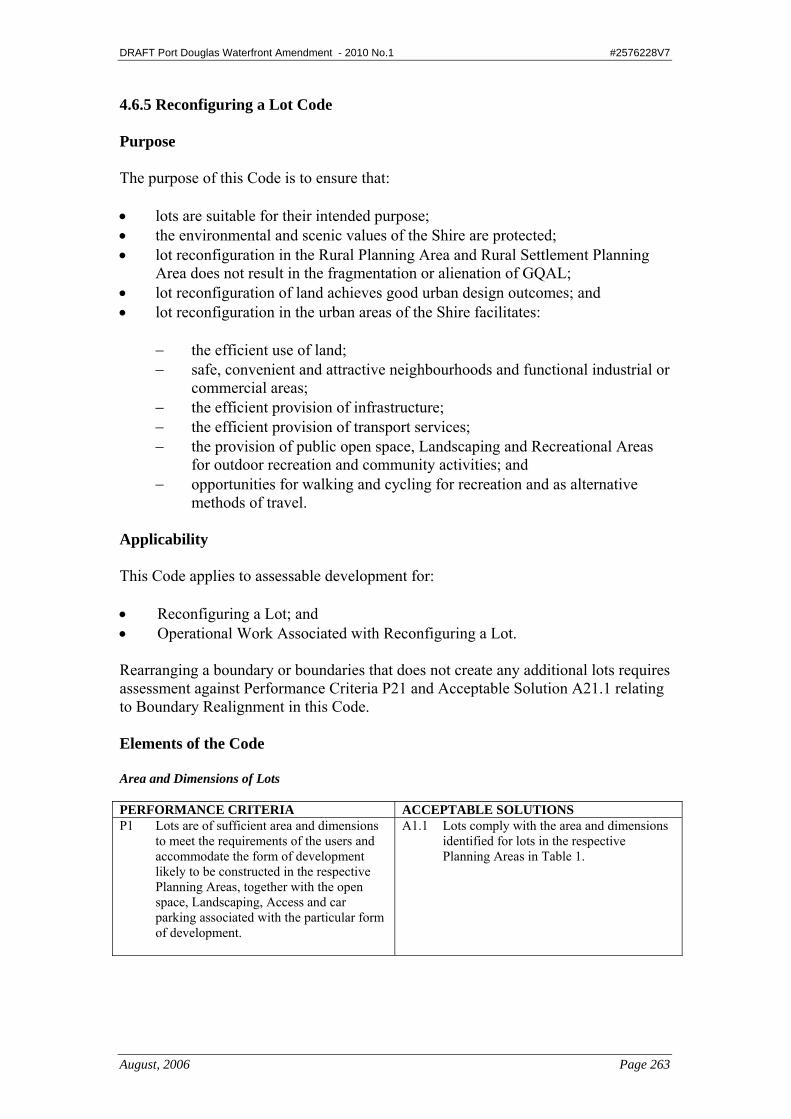
August, 2006 Page 263
4.6.5 Reconfiguring a Lot Code Purpose The purpose of this Code is to ensure that: • lots are suitable for their intended purpose; • the environmental and scenic values of the Shire are protected; • lot reconfiguration in the Rural Planning Area and Rural Settlement Planning
Area does not result in the fragmentation or alienation of GQAL; • lot reconfiguration of land achieves good urban design outcomes; and • lot reconfiguration in the urban areas of the Shire facilitates:
− the efficient use of land; − safe, convenient and attractive neighbourhoods and functional industrial or
commercial areas; − the efficient provision of infrastructure; − the efficient provision of transport services; − the provision of public open space, Landscaping and Recreational Areas
for outdoor recreation and community activities; and − opportunities for walking and cycling for recreation and as alternative
methods of travel. Applicability This Code applies to assessable development for: • Reconfiguring a Lot; and • Operational Work Associated with Reconfiguring a Lot. Rearranging a boundary or boundaries that does not create any additional lots requires assessment against Performance Criteria P21 and Acceptable Solution A21.1 relating to Boundary Realignment in this Code. Elements of the Code Area and Dimensions of Lots PERFORMANCE CRITERIA ACCEPTABLE SOLUTIONS P1 Lots are of sufficient area and dimensions
to meet the requirements of the users and accommodate the form of development likely to be constructed in the respective Planning Areas, together with the open space, Landscaping, Access and car parking associated with the particular form of development.
A1.1 Lots comply with the area and dimensions identified for lots in the respective Planning Areas in Table 1.
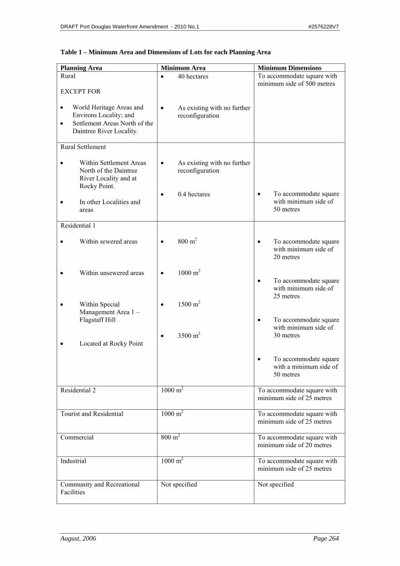
DRAFT Port Douglas Waterfront Amendment - 2010 No.1 #2576228V7
August, 2006 Page 264
Table 1 – Minimum Area and Dimensions of Lots for each Planning Area Planning Area Minimum Area Minimum Dimensions Rural EXCEPT FOR • World Heritage Areas and
Environs Locality; and • Settlement Areas North of the
Daintree River Locality.
• 40 hectares • As existing with no further
reconfiguration
To accommodate square with minimum side of 500 metres
Rural Settlement • Within Settlement Areas
North of the Daintree River Locality and at Rocky Point.
• In other Localities and
areas
• As existing with no further
reconfiguration • 0.4 hectares
• To accommodate square
with minimum side of 50 metres
Residential 1 • Within sewered areas • Within unsewered areas • Within Special
Management Area 1 – Flagstaff Hill
• Located at Rocky Point
• 800 m2 • 1000 m2 • 1500 m2 • 3500 m2
• To accommodate square
with minimum side of 20 metres
• To accommodate square
with minimum side of 25 metres
• To accommodate square
with minimum side of 30 metres
• To accommodate square
with a minimum side of 50 metres
Residential 2 1000 m2 To accommodate square with
minimum side of 25 metres
Tourist and Residential 1000 m2 To accommodate square with minimum side of 25 metres
Commercial 800 m2 To accommodate square with minimum side of 20 metres
Industrial 1000 m2 To accommodate square with minimum side of 25 metres
Community and Recreational Facilities
Not specified Not specified
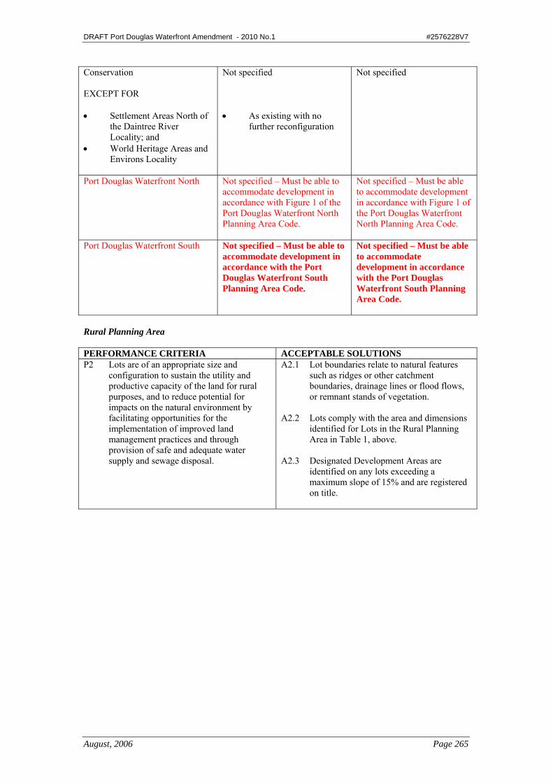
DRAFT Port Douglas Waterfront Amendment - 2010 No.1 #2576228V7
August, 2006 Page 265
Conservation EXCEPT FOR • Settlement Areas North of
the Daintree River Locality; and
• World Heritage Areas and Environs Locality
Not specified • As existing with no
further reconfiguration
Not specified
Port Douglas Waterfront North Not specified – Must be able to accommodate development in accordance with Figure 1 of the Port Douglas Waterfront North Planning Area Code.
Not specified – Must be able to accommodate development in accordance with Figure 1 of the Port Douglas Waterfront North Planning Area Code.
Port Douglas Waterfront South Not specified – Must be able to accommodate development in accordance with the Port Douglas Waterfront South Planning Area Code.
Not specified – Must be able to accommodate development in accordance with the Port Douglas Waterfront South Planning Area Code.
Rural Planning Area PERFORMANCE CRITERIA ACCEPTABLE SOLUTIONS P2 Lots are of an appropriate size and
configuration to sustain the utility and productive capacity of the land for rural purposes, and to reduce potential for impacts on the natural environment by facilitating opportunities for the implementation of improved land management practices and through provision of safe and adequate water supply and sewage disposal.
A2.1 Lot boundaries relate to natural features such as ridges or other catchment boundaries, drainage lines or flood flows, or remnant stands of vegetation.
A2.2 Lots comply with the area and dimensions
identified for Lots in the Rural Planning Area in Table 1, above.
A2.3 Designated Development Areas are
identified on any lots exceeding a maximum slope of 15% and are registered on title.
DRAFT Port Douglas Waterfront Amendment - 2010 No.1 #2576228V7
August, 2006 Page 266
Rural Settlement Planning Area PERFORMANCE CRITERIA ACCEPTABLE SOLUTIONS P3 Rural Settlement lots are located and
designed such that they:
• have a sustainable level of impact on the natural environment, having regard to water supply and water quality, effluent disposal, potential erosion and natural habitat;
• retain significant landscape features, views and vegetation cover;
• provide for a high level of residential and scenic amenity, Access to services and facilities, and safety from risk of natural hazards such as bushfire; and
• do not impact on the safety and efficiency of the Shire’s Road network.
A3.1 The location and layout of new lots does not fragment GQAL or areas of ecological or scenic value and provides for buffers that adequately protect such areas from fringe deterioration and other impacts and maximises connectivity between such areas.
A3.2 Designated Development Areas are
identified on any lots exceeding a maximum slope of 15% and are registered on title.
A3.3 The location and layout of lots minimises
the extent of cut and fill for Building area or Road construction.
A3.4 The location and layout of lots allows for
the buffering of riparian vegetation and waterways.
A3.5 Lots are buffered from any potentially
incompatible land use. A3.6 The location and layout of new lots
minimises risk from bushfire through the following measures:
• the Road layout provides for
through Roads and avoids cul-de-sacs and “dead end” Roads;
• Designated Development Areas are sited in cleared areas, away from the tops of ridges, and not on north to west facing vegetated slopes; and
• the use of firebreaks. A3.7 Lots are not located in an area affected by
noise from a State-Controlled Road.
DRAFT Port Douglas Waterfront Amendment - 2010 No.1 #2576228V7
August, 2006 Page 267
Residential 1 Planning Area PERFORMANCE CRITERIA ACCEPTABLE SOLUTIONS P4 The layout for a residential
reconfiguration greater than 10 lots, gives the neighbourhood a positive identity by:
• protecting natural features, areas
of environmental value and Watercourses;
• incorporating Site characteristics, views and landmarks;
• providing a legible, connected and safe street, bicycle and pedestrian network that links to existing external networks;
• providing community or necessary facilities at convenient focal points;
• orientating the street and lots to ensure the siting and design of residential development maximises energy efficiency;
No Acceptable Solution. (Information that the Council may request to demonstrate compliance with the Performance Criteria is outlined in Planning Scheme Policy No 10 – Reports and Information the Council May Request, for code and impact assessable development).
P5 Multi-Unit Housing is limited to a small proportion of the total number of lots in a new residential area and is dispersed to ensure conventional residential detached Houses dominate the streetscape.
A5.1 In new residential areas, not more than 15% of the total number of new lots are nominated on an approved Plan of Reconfiguration for Multi-Unit Housing, with corner lots being preferred.
Commercial/Industrial Planning Areas PERFORMANCE CRITERIA ACCEPTABLE SOLUTIONS P6 The reconfiguration layout of an
industrial/commercial area:
• facilitates the efficient use of industrial or commercial land;
• ensures minimum impact on the natural environment and on the amenity of adjacent uses;
• provides for a variety of lot sizes and complementary uses.
A6.1 A Concept Plan for the proposed reconfiguration is prepared by a suitably qualified professional and identifies the location of:
• natural features, areas of
environmental value and Watercourses;
• street, bicycle and pedestrian networks and linkages to adjoining areas;
• a variety of lot sizes and dimensions, with the minimum areas of dimensions satisfying the requirements of Table 1, above.

DRAFT Port Douglas Waterfront Amendment - 2010 No.1 #2576228V7
August, 2006 Page 268
Infrastructure for Local Communities PERFORMANCE CRITERIA ACCEPTABLE SOLUTIONS P7 Provision is made for open space that:
• meets the recreational needs of residents and visitors to the Shire;
• provides a diverse range of settings;
• creates effective linkages with other areas of open space and natural areas; and
• contributes to the visual and Scenic Amenity of the Shire.
A7.1 An area of 10% of the land to be reconfigured is provided as open space in accordance with Planning Scheme Policy No 9 – Open Space Contributions.
OR
A contribution is paid in lieu of an area being designated for open space in accordance with Planning Scheme Policy No 9 – Open Space Contributions
OR
A combination of the above, as agreed to by Council.
P8 Informal Parks and Sporting Parks are
provided and sited to meet the needs of local residents in the Shire.
A8.1 Informal Parks are provided at the ratio of 2 hectares per 1000 persons with a minimum size of Informal Parks being 0.5 – 1 hectare (Local Parks) and 3 – 5 hectares (District Parks).
AND
Sporting Parks are provided at the ratio of 2 hectares per 1000 persons with a minimum size of Sporting Parks being 1.2 – 2 hectares (Local Parks) and 5 hectares (District Parks).

DRAFT Port Douglas Waterfront Amendment - 2010 No.1 #2576228V7
August, 2006 Page 269
Road Network PERFORMANCE CRITERIA ACCEPTABLE SOLUTIONS P9 The Road network:
• is integrated and consistent with
the existing and proposed local Road network;
• is legible and retains existing features, views, topography and vegetation;
• is convenient and safe for local residents;
• facilitates walking and cycling within the neighbourhood; and
• is compatible with the intended role of the State-Controlled Road and does not prejudice traffic safety or efficiency.
A9.1 Roads are designed and constructed in accordance with the specifications set out in Planning Scheme Policy No 6 – FNQROC Development Manual.
A9.2 The Road network takes into consideration
the natural and cultural features of the Site, existing vegetation, Watercourses and contours.
A9.3 The Road network is designed to reduce
traffic speeds and volumes on local streets in residential areas to facilitate parking and manoeuvring and to integrate with the existing and proposed pedestrian and bicycle paths network.
A9.4 Direct Access is not provided to a State-
Controlled Road where legal and practical Access from another Road is possible.
A9.5 Where the created allotments have
Frontage to more than one Road, Access to the individual allotments is from the lower order Road.
P10 The Road network for
industrial/commercial reconfigurations ensures convenient movement and Access for vehicles, particularly heavy vehicles, without affecting the amenity of residential neighbourhoods.
A10.1 Roads are designed and constructed in accordance with the specifications set out in Planning Scheme Policy No 6 – FNQROC Development Manual.
A10.2 Industrial/commercial traffic is able to
Access a major Road without intruding into a residential neighbourhood.
Pedestrian and Bicycle Network PERFORMANCE CRITERIA ACCEPTABLE SOLUTIONS P11 Networks of pedestrian and bicycle paths
are provided in safe and convenient locations.
A11.1 Safe and convenient walking and cycling networks are provided to link residential areas to schools, community facilities, parks and public transport, Tourist Attractions, commercial and industrial areas.
A11.2 The pedestrian and bicycle path network is
constructed in accordance with the specifications set out in Planning Scheme Policy No 6 – FNQROC Development Manual.
A11.3 Lighting for bicycle paths is provided in
accordance with the relevant Australian Standards.
DRAFT Port Douglas Waterfront Amendment - 2010 No.1 #2576228V7
August, 2006 Page 270
Stormwater Drainage PERFORMANCE CRITERIA ACCEPTABLE SOLUTIONS P12 Stormwater runoff is contained and
managed so that it does not adversely affect:
• natural Watercourses; • surface or underground water
quality; or • the built environment either
upstream or downstream of the Site.
A12.1 Stormwater drainage is designed and constructed in accordance with the specifications set out in Planning Scheme Policy No 6 – FNQROC Development Manual.
Water Supply PERFORMANCE CRITERIA ACCEPTABLE SOLUTIONS P13 An adequate, safe and reliable supply of
potable water is provided. A13.1 Where in a water supply area, each new lot
is connected to Council’s reticulated water supply system.
AND
The extension of and connection to the reticulated water supply system is designed and constructed in accordance with the specifications set out in Planning Scheme Policy No 6 – FNQROC Development Manual.
A13.2 A contribution is paid in accordance with
Planning Scheme Policy No 11 – Water Supply and Sewerage Headworks and Works External Contributions.

DRAFT Port Douglas Waterfront Amendment - 2010 No.1 #2576228V7
August, 2006 Page 271
Treatment and Supply of Effluent PERFORMANCE CRITERIA ACCEPTABLE SOLUTIONS P14 Provision is made for the treatment and
disposal of effluent to ensure that there are no adverse impacts on water quality and no adverse ecological impacts as a result of the system or as a result of increasing the cumulative effect of systems in the locality.
A14.1 Each new lot is connected to Council’s sewerage system. AND The extension of and connection to the sewerage system is designed and constructed in accordance with the specifications set out in Planning Scheme Policy No 6 – FNQROC Development Manual. OR Where the Site is not in a sewerage scheme area, the proposed disposal system meets the requirements of relevant Sections of the Environmental Protection Policy (Water) 1997. AND The proposed on Site effluent disposal system is located on and contained within the lot in accordance with the Standard Sewage Law.
A14.2 A contribution is paid in accordance with Planning Scheme Policy No 11 – Water Supply and Sewerage Headworks and Works External Contributions.
Residential Development – Standard Format Plan with Common Property PERFORMANCE CRITERIA ACCEPTABLE SOLUTIONS P15 Lots have an appropriate area and
dimension to protect residential amenity. A15.1 The lot configuration under a Standard
Format Plan with Common Property satisfies the minimum area and Frontage provisions of the Residential 1 Planning Area Code, as set out in Table 1, above.
P16 The Setback of Residential Uses from
the Access driveways makes efficient use of the Site and provides for the amenity and privacy of residents.
A16.1 A minimum separation distance of 15 metres is provided between Residential Uses with Frontage to the Access driveway.
P17 Internal Access driveways are designed
to provide acceptable levels of safety, amenity and convenience for users, in addition to providing for visitor car parking.
A17.1 Access driveways serving more than 3 lots and a maximum of 20 lots are a minimum of 4 metres in width and provide designated areas for visitor parking at the rate of 1 car space for every 3 Houses/or other Residential Uses.
DRAFT Port Douglas Waterfront Amendment - 2010 No.1 #2576228V7
August, 2006 Page 272
P18 Communal/public open space is
provided to service the residents of the development and to contribute to the available public open space in the local community.
A18.1 The proportion of public open space and communal open space provided by the development is dependant upon the characteristics of the individual development and its proximity to nearby public open space, existing or planned. A split of 6% public open space and 4% communal open space is preferred, but will be determined on a Site/development specific basis.
P19 Boundary fencing does not have a
significant impact on the visual amenity of the local area.
A19.1 The side and rear boundary fence is a maximum of 1.8 metres in Height and incorporates decorative panels which incorporate railings, pickets and/or vegetation screening to reduce the bulk and scale of the fence or wall.
P20 The installation of Fire Hydrants ensures
that they are easy to locate and use in times of emergency and are of a standard consistent with service needs.
A20.1 Fire Hydrant installation for the development is provided in accordance with the requirements of the relevant Australian Standard.
Boundary Realignment PERFORMANCE CRITERIA ACCEPTABLE SOLUTIONS P21 The realignment of a boundary or
boundaries does not create additional allotments and achieves an improvement on the existing situation.
A21.1 No additional lots are created. AND The area and configuration of the proposed lots are consistent with the historical pattern of reconfiguration in the local area. AND An improvement on the existing situation is achieved by:
• the provision of Access to a lot
which previously had no Access; OR • the proposed lots being better suited
to the existing or proposed use of the lots, whether or not the provisions relating to minimum area and dimensions are met;
OR • the Frontage to depth ratio of the
proposed lots being greater than the Frontage to depth ratio of the existing lots.
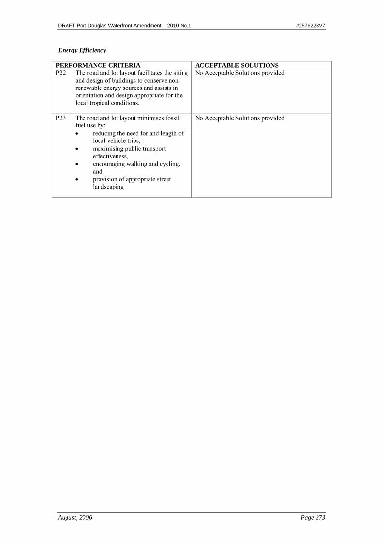
DRAFT Port Douglas Waterfront Amendment - 2010 No.1 #2576228V7
August, 2006 Page 273
Energy Efficiency
PERFORMANCE CRITERIA ACCEPTABLE SOLUTIONS P22 The road and lot layout facilitates the siting
and design of buildings to conserve non-renewable energy sources and assists in orientation and design appropriate for the local tropical conditions.
No Acceptable Solutions provided
P23 The road and lot layout minimises fossil fuel use by: • reducing the need for and length of
local vehicle trips, • maximising public transport
effectiveness, • encouraging walking and cycling,
and • provision of appropriate street
landscaping
No Acceptable Solutions provided

DRAFT Port Douglas Waterfront Amendment - 2010 No.1 #2576228V7
August, 2006 Page 301
5.1 Land Use Definitions A list of Land Use Definitions is outlined below in alphabetical order, followed by the detailed Land Use Definitions in the same order.
5.1.1 List of Land Use Definitions Aircraft Landing Facility – Commercial Aquaculture Business Facilities Camping Ground Caravan Park Caretaker’s Residence Car Park Cemetery and Crematorium Child Care Centre Display Facilities Educational Establishment Extractive Industry Health Facility Holiday Accommodation Home Activity Home Based Business – (includes Bed & Breakfast Accommodation, Forest
Stay Accommodation and Host Farm Accommodation).
Home Industry House Indoor Sports and Entertainment Industry – (includes Industry Class A and Industry Class B). Intensive Animal Husbandry Interpretive Facility Marina Multi-Unit Housing Off Premises Advertising Device Outdoor Sport and Recreation Outstation/Seasonal Camp Park and Open Space Place of Assembly Primary Industry Private Forestry Public Utilities and Facilities Restaurant Retirement Facility Service Industry Service Station Shopping Facility Short Term Accommodation Special Residential Use Staff Quarters Tavern

DRAFT Port Douglas Waterfront Amendment - 2010 No.1 #2576228V7
August, 2006 Page 302
Telecommunication Facilities Tourist Attraction Veterinary Facilities.
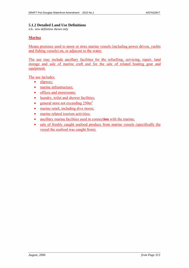
DRAFT Port Douglas Waterfront Amendment - 2010 No.1 #2576228V7
August, 2006 from Page 313
5.1.2 Detailed Land Use Definitions n.b.. new definition shown only Marina Means premises used to moor or store marine vessels (including power driven, yachts and fishing vessels) on, or adjacent to the water. The use may include ancillary facilities for the refuelling, servicing, repair, land storage and sale of marine craft and for the sale of related boating gear and equipment. The use includes:
• slipway; • marine infrastructure; • offices and storerooms; • laundry, toilet and shower facilities; • general store not exceeding 250m2 • marine retail, including dive stores; • marine related tourism activities; • ancillary marina facilities used in connection with the marina; • sale of freshly caught seafood produce from marine vessels (specifically the
vessel the seafood was caught from).
DRAFT Port Douglas Waterfront Amendment - 2010 No.1 #2576228V7
August, 2006 Page 325
5.3 Administrative Definitions A list of the Administrative Definitions is outlined below in alphabetical order, followed by the detailed Administrative Definitions in the same order.
5.3.1 List of Administrative Definitions AAA Water Conservation Rating Access AGA Energy Rating Label Basement Bed Space Biodiversity Building Clearing Council Deep Planting Defined Storm Tide Event (DTSE) Dense Planting Designated Development Area Dwelling Unit Erect Expanded House Frontage Gross Floor Area Ground Level Habitable Room Height High Bank Household Landscaping Low NOx Main Street Frontage Marine-based Industry Minor Building Work Net Lettable Area Non-residential building Other Areas Outbuilding Plot Ratio Port Douglas Waterfront Private Room R-value Recreation Area Register Remnant Vegetation Renewable Energy Certificate Residential building Residential Uses Road

DRAFT Port Douglas Waterfront Amendment - 2010 No.1 #2576228V7
August, 2006 Page 326
Scenic Amenity Self Contained Semi-Basement Setback Site Site Coverage State-Controlled Road Storey Storm Tide Storm Tide Inundation Area Urban Areas Watercourse

DRAFT Port Douglas Waterfront Amendment - 2010 No.1 #2576228V7
August, 2006 from Page 326
5.3.2 Detailed Administrative Definitions n.b.. new definition shown only Marine-based Industry Means waterfront or land based marine industry activities and facilities, which may include the following:
• maintenance, repair and refurbishing or vessels or marine equipment / machinery; and
•the provision of marine industry professional services, eg naval architects, marine engineers and surveyors, including associated office accommodation;
• wet and dry vessel storage facilities; • fuel storage and delivery infrastructure; • the sale and display of marine plant; • marine industry training facilities and services; • marine-related emergency services; and • small scale supporting commercial services and facilities.
Port Douglas Waterfront Means the collective reserves, leases and property west of Wharf Street to Dickson Inlet, from Rex Smeal Park in the north and Port Street in the south. The Port Douglas Waterfront contains and continues to provide a mix of active and passive recreation parks, historic buildings along with community, accommodation, industry and commercial activity. Dickson Inlet continues to provide harbour for marine vessels and activities, balancing the needs of the tourist industry with the environmental qualities and coastal processes of the inlet. Storm Tide Means the effect on coastal water of a storm surge combined with the normally occurring astronomical tide. Defined Storm Tide Event (DTSE) Means the event (measured in terms of likelihood of reoccurrence) and associated inundation level adopted to manage the development of a particular area. The defined storm tide event is the 1% Annual Exceedance Probability (AEP) storm tide – equivalent to 1/100 yr Average Recurrence Interval (ARI) unless otherwise indicated for essential community service infrastructure. The DTSE must also account for sea level rise and the planning period for development of a particular area.
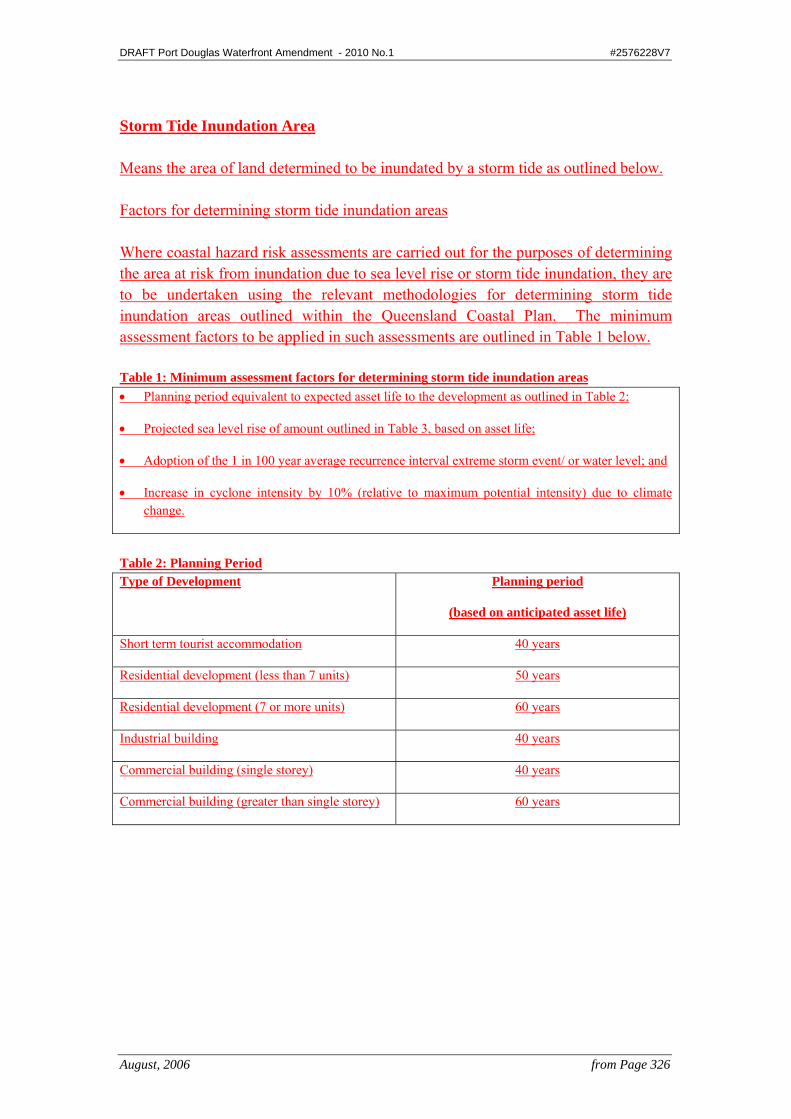
DRAFT Port Douglas Waterfront Amendment - 2010 No.1 #2576228V7
August, 2006 from Page 326
Storm Tide Inundation Area Means the area of land determined to be inundated by a storm tide as outlined below. Factors for determining storm tide inundation areas Where coastal hazard risk assessments are carried out for the purposes of determining the area at risk from inundation due to sea level rise or storm tide inundation, they are to be undertaken using the relevant methodologies for determining storm tide inundation areas outlined within the Queensland Coastal Plan. The minimum assessment factors to be applied in such assessments are outlined in Table 1 below. Table 1: Minimum assessment factors for determining storm tide inundation areas • Planning period equivalent to expected asset life to the development as outlined in Table 2;
• Projected sea level rise of amount outlined in Table 3, based on asset life;
• Adoption of the 1 in 100 year average recurrence interval extreme storm event/ or water level; and
• Increase in cyclone intensity by 10% (relative to maximum potential intensity) due to climate change.
Table 2: Planning Period Type of Development Planning period
(based on anticipated asset life)
Short term tourist accommodation 40 years
Residential development (less than 7 units) 50 years
Residential development (7 or more units) 60 years
Industrial building 40 years
Commercial building (single storey) 40 years
Commercial building (greater than single storey) 60 years
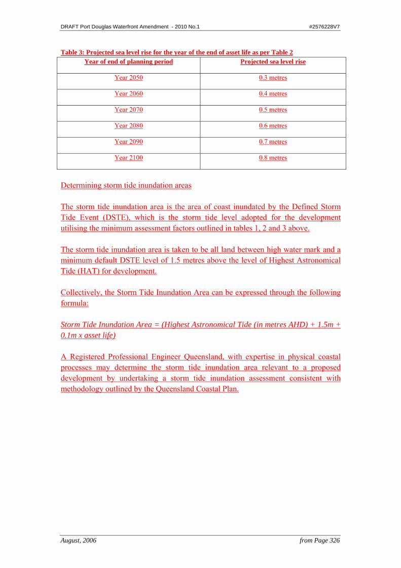
DRAFT Port Douglas Waterfront Amendment - 2010 No.1 #2576228V7
August, 2006 from Page 326
Table 3: Projected sea level rise for the year of the end of asset life as per Table 2 Year of end of planning period Projected sea level rise
Year 2050 0.3 metres
Year 2060 0.4 metres
Year 2070 0.5 metres
Year 2080 0.6 metres
Year 2090 0.7 metres
Year 2100 0.8 metres
Determining storm tide inundation areas The storm tide inundation area is the area of coast inundated by the Defined Storm Tide Event (DSTE), which is the storm tide level adopted for the development utilising the minimum assessment factors outlined in tables 1, 2 and 3 above. The storm tide inundation area is taken to be all land between high water mark and a minimum default DSTE level of 1.5 metres above the level of Highest Astronomical Tide (HAT) for development. Collectively, the Storm Tide Inundation Area can be expressed through the following formula: Storm Tide Inundation Area = (Highest Astronomical Tide (in metres AHD) + 1.5m + 0.1m x asset life) A Registered Professional Engineer Queensland, with expertise in physical coastal processes may determine the storm tide inundation area relevant to a proposed development by undertaking a storm tide inundation assessment consistent with methodology outlined by the Queensland Coastal Plan.