Little India: Indian and Cosmopolitan
28
Little India: Indian and Cosmopolitan Lecture Outline References/Reading List The Lecture A. Records of Ancient Links between India and Singapore Greek Evidence Malay Annals Archeological Evidence B. The First Indian Arrivals to Modern Singapore Early Settlement and Employment C. A Multi-lingual and Religious Indian Community D. The Little India(s) of Singapore E. The First Settlers of Serangoon (Little India) The Road and the First Indians at Serangoon Agriculture and the Early Chinese of Serangoon The Indigenous Malays and Baweanese F. The Urbanization and Commercialization of Serangoon Road, 1880s-1941 Changing Environment and Development Overpopulated Enclaves and Increased Indian Immigration Commerce, Industries and Occupational Patterns Chinese Industries and Symbiotic Links G. Life and Trades along Little India H. The Religious Dimension Hindu Temples and Festivals The Indian Muslim Mosques The Buddhist Temples The Christian Churches I. Little India in Transition, 1942 – 1990s Days of the Rising Sun The Post-war Years The “Construction” of “Little India” J. Concluding Remarks Endnotes The References 1
Transcript of Little India: Indian and Cosmopolitan
Little India: Indian and Cosmopolitan
Lecture Outline References/Reading List The Lecture A. Records of Ancient Links between India and Singapore
Greek Evidence Malay Annals Archeological Evidence B. The First Indian Arrivals to Modern Singapore Early Settlement and Employment C. A Multi-lingual and Religious Indian Community D. The Little India(s) of Singapore E. The First Settlers of Serangoon (Little India) The Road and the First Indians at Serangoon Agriculture and the Early Chinese of Serangoon
The Indigenous Malays and Baweanese F. The Urbanization and Commercialization of Serangoon Road, 1880s-1941 Changing Environment and Development Overpopulated Enclaves and Increased Indian Immigration Commerce, Industries and Occupational Patterns Chinese Industries and Symbiotic Links G. Life and Trades along Little India H. The Religious Dimension Hindu Temples and Festivals The Indian Muslim Mosques The Buddhist Temples The Christian Churches I. Little India in Transition, 1942 – 1990s
Days of the Rising Sun The Post-war Years The “Construction” of “Little India”
J. Concluding Remarks Endnotes
The References
1

Core Readings • Chopard, Kelly. Rochore Eyewitness. Singapore: Landmark Books for Rochore Citizen's
Consultative Committee, 1989. • Falaq Yusuf Kagda (Ed). Muslims in Singapore – A Shared Vision. Singapore: Times
Edition Pte Ltd, 1994. • Makepeace, Walter, Gilbert E. Brooke, Roland St. J. Braddell (ed). One Hundred Years of
Singapore. Vol 1&2, Singapore: Oxford University Press. • Pillai, Nirru K. (ed). Arpanam: A Dedication: Facets of Singapore Indians, Singapore:
Landmark Books for the Organising Committee of a Dinner by the Indian Community, 1994.
• Siddique, Sharon & Nirmala Puru Shotam. Singapore’s Little India: Past, Present and Future (2nd ed with epilogue), Singapore: Institute of Southeast Asian Studies, 1990.
• Siddique, Sharon & Nirmala Shotam-Gore (ed). Serangoon Road: A Pictoral History, Singapore: Educational Publications Bureau, 1983.
• Historic Districts: Conservation Guidelines for Little India Conservation Area. Urban Redevelopment Authority, 1991.
Further Readings • Hon, Joan. Tidal Fortunes: A Story of Change: The Singapore River and Kallang Basin.
Singapore: Landmarks Books, 1990, • Hughes, David Rees. The Peoples of Malaya. Singapore: Donald. Moore, Eastern
Universities Press, 1965. • Mialaret, Jean Pierre. Hinduism in Singapore: A Guide to the Hindu Temples of Singapore.
Singapore: Donald Moore, Asia Pacific Press, 1969. • Pearson, H. F. Stories of Early Singapore. London: University of London Press, 1953. • Sinha, Vineeta. Hinduism in Singapore: A Sociological and Ethnographic Perspective.
Singapore: Department of Sociology, National University of Singapore, 1987. • Yeoh, Brenda S. A. & Lily Kong. Portraits of Places: History, Community and Identity in
Singapore. Singapore: Times Editions, 1995. • Recollections: People and Places. Singapore: Oral History Department, National Archives
of Singapore, 1990. Dissertations on Little India at NUS (Theses) • Balakrishnan, Dhinagaran, “The Ramakrishna Mission in Singapore: 1928-1982”,
Department of History, Faculty of Arts and Social Sciences, National University of Singapore, 1988/89.
• Balber, Kaur, “Evaluation of the Conservation Proposals of Little India”, School of Building & Estate Management, Faculty of Architecture & Building, National University of Singapore, 1992.
• Das, Gopal, “Kaliamman Temple Serangoon Road, Singapore: A Study of the Economic and Social Position of a Hindu Temple”, Dept. of Social Studies, University of Malaya, 1958.
• Kan Sok Cheng, “Conservation Scheme of Little India”, School of Building & Estate Management, Faculty of Architecture & Building, National University of Singapore, 1988.
• Kumar, Suresh, “Singapore Indian Association, 1923-1941”, Department of History, Faculty of Arts & Social Sciences, National University of Singapore.
• Kwang, Chan Nam, “Hindu Temples in Singapore”, School of Architecture, Faculty of Architecture & Building, National University of Singapore, 1983.
2

• Manokara, S., “Growth and Decay: A Study of change in two Hindu Temples in Singapore”, Dept. of Sociology, Faculty of Arts and Social Sciences, University of Singapore, 1979.
• Nafizath Bharzana Begam, “The Making of a Place: History, Community & Identity of Little India”, Dept. of Geography, Faculty of Arts & Social Sciences, National University of Singapore, 1997.
• Nayagam, Francis, “Little India: A Study of Mutual Help & Community Structure in Lower Serangoon Road”, Dept. of Social Work and Social Administration, University of Singapore, 1971.
• Sim Sook Wei, “The Success of Ethnic Trades in Conservation Area: Little India”, School of Building & Estate Management, Faculty of Architecture & Building, National University of Singapore, 1995.
• Singh, Neeta Devi Dharam P., “The Life of Rajabili Jumabhoy, a Pioneer Kutchee Khoja Immigrant in Singapore”, National University of Singapore,1996.
• Sinha, Vineeta, “Hinduism in Singapore: A Sociological and Ethnographic Perspective”, Department of Sociology, Faculty of Arts and Social Sciences, National University of Singapore,1987.
• Suneeth, Changaroth Natyala, “Little India”, School of Architecture, Faculty of Architecture & Building, National University of Singapore, 1982.
• Syed Mohamed Baquir bin Md. Ibrahim, “The Tamil Muslim Community in Singapore”, Department of Social Work, Faculty of Arts and Social Sciences, National University of Singapore, 1973.
• Yeo, Tracie Chieh Sze, “Socioscopes in a Global City: Singapore’s Little India”, Dept. of Geography, Faculty of Arts & Social Sciences, National University of Singapore, 1999.
• Yeo Chor Siang, “A North Indian Community in Singapore: Continuity and Change among Bihari Dairymen”, Department of Sociology, Faculty of Arts and Social Sciences, National University of Singapore, 1983/84.
The Lecture A. Records of Ancient Links between India and Singapore1
Greek Evidence Links between India and Singapore goes back to ancient times. In the first century A.D., Claudius Ptolemaeus, a famous Greek astronomer, collected astronomical observations from the countries around the Indian Ocean in order to determine their approximate locations. One of these, Sabana, lay in the area of modern Singapore. Sabana was a nominon emporion or designated foreign trading port, part of a chain of such trading centres which linked Southeast Asia with India and the Mediterranean 2,000 years ago. The Greeks themselves never reached Sabana. According to Ptolemy, Sabana should have lain somewhere in the vicinity of the Johor-Riau-Singapore area. The Malay Annals The Sejarah Melayu or "Malay Annals", compiled around 1435, contains information passed down from much earlier times. The first section of the Malay Annals tells the story of a great Indian ruler, Raja Shulan, who after conquering all of India, set his sights on China. However, he only had a vague idea of where China was. The Chinese, learning of Raja Shulan's intent, and wishing to avoid conflict, decided to employ a stratagem. They sent an
3

old ship crewed by a group of aged men to Singapore! Raja Shulan, on his way to China, also stopped in Singapore. He met the doddering Chinese sailors and asked them how much further away China lay. The old sailors informed Raja Shulan that China was so far away that when they had set out, they were still youths. Raja Shulan then despaired of reaching China and decided to return to India. The following chapters of the Malay Annals goes on to give an account of the five kings of ancient Singapore, which is depicted as the first great Malay trading centre. Archaeological Evidence A large inscription on stone was found at the mouth of the Singapore River, with a long text written in the pre-Islamic script common in Malaysia and Indonesia, based on an old south Indian alphabet called Pallava. It was wantonly blown up by the British military, but a fragment was salvaged and is on display in the Singapore History Museum. Two other fragments were sent to Calcutta. In 1926 a cache of ancient gold jewellery was found on Fort Canning. The jewellery, now in the Singapore History Museum, bears designs derived from Indian art and mythology, which were popular in ancient Southeast Asia. Archaeological research at Fort Canning has yielded tens of thousands of ancient artifacts. One of the most unusual of these is a bangle made out of glass of several colours: white, brown, yellow, and green. The bangle was made in northwest India in the 13th century. Another sign of contact with south Asia is a copper or bronze coin, excavated at Parliament House in 1995; the coin was minted in Sri Lanka in the late 13th century. B. The First Indian Arrivals to Modern Singapore The Straits Settlement had formed part of British India until 1867,2 and hence, it was not difficult for Indians to migrate to Singapore throughout the nineteenth century. The first wave of Indians to the Straits Settlements came across the Bay of Bengal to work on sugar, spice, tapioca and coconut plantations in Penang and Province Wellesley.3 Early Settlement and Employment When Raffles established a trading centre at Singapore in 1819, the Indian pioneers settled along the Singapore River and in Telok Ayer. This was partly due to Raffles’ Town Plan which allotted the Indians these areas for settlement.
In the 1820s, with the number of Indians from Madras (Chuliahs) greatly increased in the Settlement, the Indian migrants here petitioned the British to appoint a “captain” or headman to govern their affairs.
Figure 1Map of the Town area in the 1820s
4
Figure 2 View of Telok Ayer from Mount Wallich A site up the Singapore River was also allocated to these Indians as their assigned site of residence. There were few Bengalis in the early days, and they were mainly engaged in menial work. The Klings, South Indians, were mainly traders. Many of the Indians were also petty shopkeepers, boatmen and servants.4
Figure 3 Indian Ligthermen along the Singapore River
Present in large numbers were also hundreds of boats manned by Indian lightermen who plied their trade from the coastline that stretched from Tanjong Rhu to Telok Ayer, and into the Singapore River.5 Hence, historically, the first “Little India” was to be found at Telok Ayer (Chinatown), where the Indians settled first along Chulia Street, then along High Street, Arab Street.6 From here, the Indian population grew steadily. While there were only 2,157 Indians on the island in 1836, there were 12,973 Indians here by 1860.7
Some of the earliest Indian immigrants arrived not by choice but as convicts, after Singapore was made a British penal station in 1825. Large numbers of Indian convicts were sent here to exploit their labour to build roads, bridges and public establishments. They were all housed at the Bras Basah Road Goal from the 1840s. Naturally, an Indian enclave also evolved around the area. The less dangerous prisoners guarded the more hardened criminals, and they were allowed to have families within the goal. In time, the area adjacent to the goal saw a large number of Indians congregating there.
5

Figure 4 Indian dhobys
As most of them were “dhobys” (laundry-men) by trade, the Bras Basah stream and the wide-open field having made the area conducive for this profession, the district came to be called Dhoby Ghaut. When the Indian convicts finished serving their sentences, many of them who returned to India, found things so uncongenial that they soon returned to the Straits and settled down as shopkeepers, cow-keepers and many other forms of occupation.8 C. A Multi-lingual and Religious Indian Community Not all Indians are Hindus or Tamil speaking. The Indian community that initially found roots comprised of a diverse group that spoke different tongues and attended different places of worship. Like the Chinese, the Indians who settled along Telok Ayer also established their own religious institutions along the road that was once the shoreline. The Nagore Durgha and the Al Abrar Mosque were established in the early nineteenth century and had become the main sites of Indian Muslim worship. Along the nearby South Bridge Road, the Indian Hindus have their Sri Mariamman Temple nearby the Indian Muslim Jamae Mosque at Pagoda Street. This multi-religious constitution of the Indian community can also be seen along the swamp environs of nineteenth century Serangoon Road. There, the Abdul Gafoor Mosque co-existed with the other Indian temples of Serangoon Road. While it would be generally true that the Indian Muslims would have originated from North India, and the South Indians were generally Hindus, there are exceptions to be found among the Indian migrants of Singapore. The North Indian Hindus who arrived from Uttar Pradesh and Bihar at the beginning of the twentieth century found their way to the cattle area of Serangoon. In the prewar years, they worshipped at the Krishna Temple at Waterloo Street.9
6

By the late nineteenth century, the Roman Catholic, Methodists and Anglican Christians were also establishing churches for the Indians of Singapore, and they were all built just at the periphery of the Indian main enclave then, Serangoon Road.10
Besides being divided along religious and origin lines, the Indians are also divided along dialectal lines, for example Tamil, Hindi, Punjabi and etc. In short, in attempting understand the nature of the Indian community of Singapore, one must not simply juxtapose them vis-à-vis the other ethnic groups here, namely, the Chinese, Malays and others. The Indian community of Singapore has always been a microcosm of the larger Indian population of the Indian subcontinent. It was never a homogenous grouping. And this has important bearing in attempting to understand the developmental processes that occurred in Little India. D. The Little India(s) of Singapore Before one launches into the story of Little India, it must be noted that the Little India of Serangoon Road was not the first Little India, nor was it the only one. The pioneering Indian migrants of the early 19th century first settled along Chulia Street, then along High Street, Arab Street and finally, when there was little more room left in these areas, they settled along Serangoon Road.11 Hence, the first Indian enclaves in Singapore were all found outside the Serangoon Road area.12
Early Indian migration to Singapore was largely an urban trend, as can be seen by the Indian concentration in Tanjong Pagar. Most of these Indians took on jobs linked to an urban economy, employed as labourers, stevedores, traders, shopkeepers, hawkers, shop assistants and as clerks.13 At Telok Ayer, the Indians who congregated along Chulia and Cross streets, were mostly hawkers who sold milk from house to house with milk buckets balanced on a bar slung across their shoulders.14 There were also many Indian traders (North and South) who were tapped onto the settlement’s entrepot trade, buying and selling all sorts of spices and commercial goods. Each of the predominant nationalities in Singapore had its own name for Cross Street. The Chinese called it Kiat Leng Kia Koi (Klingman’s Street) or Kling Street, so called because of the many Kling (mainly boatmen) who used to live here in the 1820s. The Tamils called it Palkadei Sadakku (Street of the Milk Shops) and the Malays have a similar name, Kampong Susu, because of the thriving goat milk business (there were also Indian shops selling mutton, herbs and curry). E. The First Settlers of Serangoon (Little India) Unlike Chinatown and Kampong Glam, Little India was not one of the original ethnic enclaves designated in the Raffles’ Town Plan of the 1820s. As such, the evolution of Serangoon Road into a predominantly Indian district was a gradual one, which included push and pull motivations that spanned over a century. The Road and the First Indians at Serangoon Serangoon Road was one of the earliest roads to be built in Singapore after those in the city centre. In 1828 a map by Lieutenant Jackson labeled Serangoon Road as a “road leading across the island”. The development of this road, and also Bukit Timah Road, was linked to
7

the cultivation of gambier and pepper in the interior.15 The need to transport these crops into town for export necessitated the development of roads cutting across the island. By 1845, the extensive cultivation of gambier and pepper on the island had left great parts of the island de-forested. Hence, a great number of cultivators moved further north, across the Straits into Johore, to found their new plantations. The produce from Johore, however, still had to be transported to the Singapore docks to be re-exported. Therefore, the roads in the interior had to be extended to link up with the habours in the north. In time, the Chinese named Serangoon Road “Hou Gang Lu” or “Ow Kung” (back of the Port Road).16 The earliest Indians who ventured down Serangoon Road were pulled by economic opportunities found there. Indians used to call Serangoon Road ‘Soonambu Kambam’, which literally means ‘Village of Lime’. In the old days, lime was an important element in the manufacture of Madras Chunam, a kind of brick that was introduced from India. A hardened mixture of egg white, sand, shell, lime, sugar and coconut husks would be polished with stone to a smooth finish and was used to build houses. In the late 1820s, when the government set up its own brick kilns and lime pits along Serangoon Road, many Indians found employment in these kilns. The first recorded Indian brick business belonged to Naraina Pillai, an Indian who arrived with Raffles in 1819 when the latter was on his second visit to Singapore.17 After the kilns were discontinued in 1860, other trades related to the cattle industry, became the new “pulls” in attracting more Indian migration to this district. As a result, the genesis of an Indian settlement began there.
Figure 5 Map of Serangoon Road
Besides the kilns of the early days, Balestier’s massive sugar plantation also attracted a great number of Indian labourers to the Serangoon area.18 The early Indian settlers to this district were also attracted to the “sireh”, betel-leaf, that were cultivated on both sides of Serangoon Road in the 1830s. Indians have always been known to be voracious chewers of ‘sireh’.19 From the 1860s, the development of the Serangoon area was intricately linked with the cattle and buffalo trade that flourished as a result of the abundance of water and fodder, crucial to the trade. The buffaloes were also most crucial means of transport for the agricultural enterprises in the interior of the island. The fresh-water ponds (particularly on the Race Course side of the road) and the mangrove swamps of Kampong Kapor, not forgetting the Rochore River itself, all provided bathing areas for water buffaloes.20 Perhaps what is most
8

pertinent here is that the Indian community was greatly involved in the cattle trade and related industries up till the prewar years. Just as the Bras Basah stream ideal for the dhobies to congregate there, the wetland environment of Serangoon Road centred the cattle business there, and hence, led to the rooting of more Indians to the district. Agriculture and the Early Chinese of Serangoon Like the Indian pioneers of Serangoon Road, Chinese farmers had already set up homes on swampy grounds of the Rochore side of the Serangoon Road since the 1820s.21 The swampy grounds of the district had not only made the area conducive for cattle rearing, it also meant that a whole variety of agricultural enterprises were also made possible there. There were padi fields extending beyond the sireh fields on the west side of Serangoon Road, and Chinese vegetable gardens at what is now the area between Syed Alwi and Balestier roads, and Lavender Street. By the early 1840s, sugar plantations (Balestier Plain) were added to this agricultural mix. The cutting of Rochor Canal, completed in 1836, was most likely motivated by the irrigation needs of Chinese immigrant farmers of the district.22 The Indigenous Malays and Baweanese Among the early residents of Serangoon Road were the Malay-Boyanese (Baweanese) who established themselves in an area called Kampong Kapor. The Baweanese were already residents of Serangoon Road when the first Indians arrived, and many of them were employed in the construction of the Racecourse nearby in the 1840s. Subsequently, many of them were employed as horse trainers there. The Baweanese were also employed as carriage and bullock-cart drivers, syces and gardeners.23 And as the Baweanese were Muslims, Kampong Kapor easily absorbed many Indian Muslims who found their way there. The Indian Muslims were mainly labourers at the port and in the police force.24
From the onset, the Baweanese settled and organized themselves into pondoks (lodging houses) communities where they formed a rudimentary social structure that ensured that their welfare was taken care of. These pondoks usually catered to those from the same district or village and were modeled after the pondoks in Bawean, which covered a far greater area, while the ones in Singapore were usually just single units. The pondok system extended beyond providing shelter
and companionship for new Baweanese arrivals as those already here would usually recommend their fellow villagers or kinsmen to their employers.25 By the late nineteenth century, Malay kampongs covered much of the swampland and riverside areas stretching from lower Serangoon Road to the coast. This was because there were opportunities here for washing and other waterside activities.26
9

F. The Urbanization and Commercialization of Serangoon Road, 1880s-1941 Serangoon Road remained a rural outback for most part of the nineteenth century, and this was greatly determined by its swampy geographical terrain which made the district most ideal for the cattle and related industries. Towards the turn of the century, both sides of Serangoon Road were lined with plantations and villages. However, a series of events and policy changes led to a new phase of development for Serangoon Road. By then, this hitherto undeveloped district had become the ideal site for urbanization. Population pressure in the other ethnic enclaves and built up areas had pushed many to search for new areas of habitation and commerce. And Serangoon Road, situated at the periphery of the town limits, and having had ample space and the right conditions, was poised to pull large numbers of new migrants there.
Figure 6 Serangoon Road (1900s)
Changing Environment and Development Serangoon Road began as an important artery of commerce and transport for all the plantations in the interior of the island that were along the route to the Serangoon Harbour. In time, villages as well as plantations sprouted in a haphazard manner all along Serangoon Road, including the stretch from Selegie to Syed Alwi roads, the core area of present-day Little India. The development of Serangoon Road meant that the “old” had to go, and the “new” introduced, and this was, at times, helped along by critical events. On 3 April 1883, a destructive fire swept through the village at Kampong Kapor. 110 houses were razed and that left 1020 people homeless.27 This devastation, though horrific, presented an opportunity to rebuild and renew one part of Serangoon Road. However, this process took many years to begin. The first concrete step towards urban renewal of the district actually began just after 1900, perhaps because the district was still a “cattle” area. The fire did not destroy the swamp nor were the ponds affected. The draining of the swampy areas of Kampong Kapor began after the turn of the century and this paved the way for the construction of new roads. These roads included Rowell Road, Syed Alwi Road, Kampong Kapor Road, Lembu Road, Baboo Lane, Upper Perak Road and the full length of Desker Road was further extended and developed. The main motivation for this was the commercial activities related to the cattle trade in the area (for example, slaughterhouses).28
Figure 7 Cattle Rearing at Serangoon
10

In 1911, a government Gazette was passed to initiate the Kampong Kapor Improvement Scheme. The proposed area for redevelopment encompassed the areas between Jalan Besar and Serangoon Road, from Dunlop to Syed Alwi roads. The scheme was deemed necessary because “certain houses, courts and alleys were unfit for human habitation, and the bad arrangement and the bad condition of the streets and houses and groups of houses were dangerous and injurious to the health of the inhabitants.”29 Clearly, the areas around Kampong Kapor had degenerated into slump-like dwellings by the 1900s. It was thus decided to bring down the old dwellings, re-do all the streets (some becoming through roads) and lay drainage across the district.30 This rebuilding of Kampong Kapor opened the doors for the reconstitution of the demographics in the area. Hence, from the 1900s, the next wave of Chinese settlement occurred within this area.31
Ironically, the livestock trade of Serangoon Road, which contributed to the rural outlook of the district, was also instrumental in forging new small industries and business all over the Serangoon district after 1900. However, to urbanize and introduce modern commerce into the district, the removal of
the cattle trade was inevitable. Vast swamplands had to be filled
and shophouses and residences built. Cattle rearing was finally removed from the municipality by a government gazette in 1936. The decline of the cattle trade in the 1930s also forced some livestock entrepreneurs to divert their properties and other investments in the Serangoon Road area to other uses. Fortunately, the architectural styles of the cattle sheds had easily enabled their conversion to the shophouse architecture popular in the district at that time. Thus, as the cattle left, and people filled their places, Serangoon Road’s development into a commercial-residential area was greatly accelerated.32 But on a lighter note, buffalo-driven carts were still a common sight along Serangoon Road even till the 1930s.
Figure 8 Plans of Shophouses along Serangoon Road
Interestingly, prior to urbanization, many European and Eurasians considered old Serangoon a suburban area where they had numerous bungalows, scattered between the swamps, cattle sheds and plantations. These buildings were one of the first residential buildings erected along Serangoon Road. The paths leading from the main Serangoon Road to these bungalows, also known as non-through offshoot roads, formed the beginnings of roads that exist today in Little India. These include Cuff Road, Desker Road, Dunlop Street, Norris Road, Rappa Terrace and Rowell Road.33
Figure 9 An European Bungalow at Serangoon
11
Overpopulated Enclaves and Increased Indian Immigration Indian migration to Singapore although slow, had increased exponentially over the decades. The official census for 1836 noted that there were only 2,157 Indians on the island, and this number was to increase to 12,973 by 1860.34 The approximate increase in the size of the Indian community in Singapore for this period was 450 annually. By 1931, the community had grown to 51,019. The annual increase from 1860 was approximately 630. By 1941, the Indian population stood at 76,000.35 That is, the rate of annual increase in the 1930s was 2,400.36 The general enlargement of the Indian community through the decades meant that it was only a matter of time before the earliest Indian enclaves would no longer be able to accommodate further increases within the community. The pioneering Indian migrants of the early nineteenth century had first settled along Chulia Street, then along High Street and Arab Street.37 After 1900, when there was little room left in these areas, they gravitated towards Serangoon Road, the remaining enclave that still had room for them.38
At the beginning of the twentieth century, a new group of Indian migrants also found their way to Serangoon, attracted by the cattle industry that was still thriving there. They were North Indian herdsmen from the border areas of Uttar Pradesh and Bihar. According to sources, they were from two Bihar villages, namely Lachu Tola and Basingha and they first settled on the left bank of the Rochor Canal in the Kandang Kerbau area. Together, they formed a sub-community of their own. Commerce, Industries and Occupational Patterns The appearance of more shophouses along Serangoon Road after 1900 also heralded the transition of Serangoon Road into a more commercialized district was a gradual one, and would continue on well into the postwar years. One significant factor for this change was the arrival to Singapore of many more Indians who were engaged in the construction industry. Once the other ethnic enclaves became too small to accommodate them, they found their way to Serangoon Road. This increased concentration of Indians in the area in turn resulted in the rising demand for retail and service activities associated with the Indian community. The opening up of Serangoon Road to the retail business also meant that the other ethnic group that was also greatly involved in commerce, the Chinese, would also eventually make their presence more greatly felt. When more Indians made their way to Serangoon to settle down to form a community, various businesses also sprouted all over the area to meet the needs of the Indians there. Around Buffalo and Chander roads, where most of the Indian herdsmen from Uttar Pradesh were settled, both Bengalis and Tamil Hindus milkmen, went from house to house with their goats and cow to ply their trade, bringing their clients truly fresh milk.
12

From this milk, the Indians made an ethnic delicacy, “thairu”. It was a common sight to see Indian women along Serangoon Road traveling from house to house to sell their fresh ‘thairu’.39 By the 1930s, the main cattle rearing areas had also extended to Dunlop Street where the cowherd, generally from Northern India, grazed his cattle, milked them and delivered fresh milk to the wealthy residents of the city before dawn each day, first on foot and then later on bicycle.40
Figure 10 The Indian Milkman Most of the Indian Muslim slaughterhouses and tanneries were situated along the Jalan Besar-Sungei Road areas. The famous Tekka Market, erected in 1915 at the junction of Serangoon and Bukit Timah roads, would have been one of first centralized sites where retailers sold their cattle produce.
Cattle produce was not the only commercial value these animals had. They occupy a vital place in the history of transportation in pre-war Singapore. Horses were not widely used to transport goods, nor had motor-driven trucks made any impact till the late 1920s. Hence, the bullock cart was the main transportation vehicle for commerce till the inter-war years. Chinese Industries and Symbiotic Links Sprouting alongside the cow sheds, tanneries and abattoirs were wheat-grinding sheds, sesame oil presses, rattan works, rubber smoke-houses and pineapple factories. Although these industries seemed unconnected, they had a symbiotic
commercial relationship centered on the buffalo and the wet environment. Producers of rattan for instance, required abundant amounts of water that the area had.41 In addition, the ready availability of buffalo transport in the area made the area most ideal for the industry. But more importantly, the rattan by-products, just as the dregs obtained from pineapple skins, were recycled and used as cattle feed. Hence, nothing was wasted as everything was converted into material of commercial value.
Figure 11 A Bullock Cart
Commerce and industry also transformed Serangoon Road in other ways. To support the retail business, multi-level shophouses made their appearance all over the district where ponds, bungalows and farms once were. The Kampong Karpor Improvement Scheme, of course, had also paved the way for change. But more pertinently, where there were commercial opportunities, one would also find the Chinese. At the junction of Kerbau and Race Course roads, there were 4 two-storey shophouses which were owned by Seah Liang Seah, the son of Seah Eu Chin, a most important Teochew merchant in the mid-nineteenth
13

century.42 Mr Seah got into the pineapple preserving business at around the turn of the century. His firm, Chin Giap, was located at Serangoon Road, presumably located at the shophouses listed above. In 1901, Seah’s son, Seah Eng Keong, took over the running of this firm and their brands, “Tiger” and “Defiance”, became highly reputable in Europe and the Far East. During peak periods, 250 men were employed to meet canning schedules.43 It is clear that the new wave of Chinese migrants who settled in along Serangoon Road in the 1900s were led there by the job opportunities arising from the creation of these industries.
Figure 12 Coolies unloading pineapples at Serangoon
G. Life and Trades along Little India As more and more Indians made the initial stretch of Serangoon Road their home, the district eventually took on the semblance of a cultural enclave – the “Little India” of Singapore. Much of this creation must also be attributed to the fact that the Indian community is a colourful one. Since the pre-war years, the Five-foot ways of Serangoon Road have been filled with garland-makers, parrot astrologers, goldsmiths, luggage shops, moneylenders, silk saris, tailors, food and food-related establishments, which included spice and provision shops, and almost everything and anything Indian.44
There were however, some trades and
occupations that were identified with different groups of Indians. The South Indian Tamils were usually milkmen, labour supply contractors, money-changers, tailors, travel agents, textile sellers or worked in provision shops they owned. The Tamil Muslims sold mutton at Kandang Kerbau market while the North Indians worked as watchmen for big bungalows, milkmen or bread sellers. Some of them worked in their own provision shops or shops trading in leather bags.45
Figure 13 Garland Maker Figure 14 Indian Retailers
Among the most visible trades along Serangoon Road were the glittering wares of the Indian goldsmiths. In the old days, there were a lot of goldsmith shops around Buffalo Road and
14
Kerbau Road, whose staff were dressed in traditional outfits comprising of ‘wayshti’.46 Gold jewelry is very much a part of the Indian “cultural ornaments” that the Indian community flaunts during festive occasions. Hence, with the Indian community congregating along Little India, a multitude of goldsmiths centred their trades there too. According to one account, goldsmiths had made their appearance along Little India only after the war,47 but this cannot be ascertained. There were also many fortune-tellers found along Serangoon Road – palmistry, numerology, astrology, and parrot-astrology. In parrot-astrology, a parakeet picks a card from a stack of 27 lucky fortune cards (an Indian astrological system). Each try used to cost a dollar. These parrots were trained to select fortune cards with pictures of deities and lucky messages, and entertain customers by dancing and being friendly with them. In return, they were fed with fruits, nuts, and chilies to develop their intelligence. Customers consult on a variety of matters such as marriage, money, business and work, as well as visit on special occasions like festivals and birthdays.48 In the early days, parrot astrologers were also commonly seen making house calls, besides being along the corridors of shophouses, temple grounds and streets, particularly during the festive seasons. Today, although there a few of them left, everyone can still find one standing along Serangoon Road with only a small table, parrots, some charts and a notebook.49
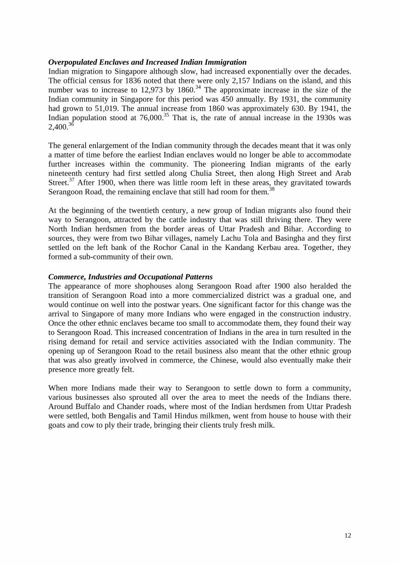
Snake Charmers were also once part of the street scene of pre-war Little India. These brave men would spread a canvas where there were open grounds and entice the snakes to emerge from their baskets with their musical flutes. Usually, a larger crowd would gather to watch these performing serpents. Most of them would come from a village called Poona in Bombay.50 There were many other colours, fragrances and sounds of Serangoon Road that made it “Little India”. From the flower and garland stalls to the spice and textile shops of the famous philanthropist, P Govindasamy Pillai, Serangoon Road was, has been and still is, the place
Indians from all over Singapore come to meet their “Indian needs”. Especially during Thaipusam, Deepavali and other prayer and festival days, Serangoon Road comes alive.
Figure 15 Indian Snake Charmers
H. The Religious Dimension The religious dimension in the Little India story is a most important angle to understanding that the main Indian enclave in Singapore was truly cosmopolitan, multi-ethnic and religious, a microcosm of the larger migrant society. Hindu Temples and Festivals Setting up a place of worship was very important to every Indian wherever they settled. In India, every village or town had a shrine or place of worship, and so, the first Hindus who settled along Serangoon Road in the nineteenth century erected small shrines along the road
15

to worship their gods, give thanks, and to ask for protection and help. Among one of the first of such shrines was what was to become the Sri Perumal Temple. Built in 1855, the land on which the shrine was built was purchased by an Indian called Narasinga.51
Till the 1960s, the temple was known as the from ‘Narasinga Perumal Kovil’. ‘Peru’ means admirable while ‘Mal’ means central, thus Perumal means ‘the admirable one of the trinity’.52 Following the Sri Perumal, two other temples were established in the late nineteenth century, the Sri Vadapathira Kaliamman and the Sri Veerama Kaliamman.53 Both temples began as private shrines, or temples, that were meant for sub-groups in the larger Indian community of the district. Among the choices of gods or deities the Indians chose, it was important that they were relevant to the lives of the peoples who worshipped them. This was extremely important as the Indians believed that the supernatural plays a major role in their lives, and in order to ward off evil, disease, ill-fortune and demons, there was a need for the gods to be appeased. Therefore the goddess Kaliamman, a powerful goddess and the destroyer of evil, was appropriately chosen as
the protector of the Indians in this area who would safeguard and protect them. Hence, the establishment of the Veerama Kaliamman Temple.54
The Hindu temples, however, were not merely icons of Indian architecture along Serangoon Road. They have always been the centres of Hindu life and worship. Indians from all over would gather at their temples on Tuesdays and Fridays, the two days of the week regarded as holy days by the Hindus.55 Hence, Indian shops along Serangoon Road selling garlands, flowers and other material necessary for Hindu worship are always bustling with activities. On festive occasions, like Thaipusam, throngs of people would descend on Serangoon Road to see the Thaipusam processions and “Chariot Runs”. The road would also be crowded with people during Deepavali.
16

The most important Indian religious festival is Thaipusam. This festival derives its name from ‘Thai’, the month of the Hindu calendar and ‘Pusam’, the name of the full moon day in the zodiacal period. It is the festival of Subramania, youngest son of the Siva, the most powerful of the gods of the Hindu Pantheon. Subramania, whose chariot is the sacred peacock, is depicted with six heads and twelve arms, each representing various divine aspects and powers. He is the wielder of the lance of victory and has thirty-seven names. During this festival, the Sri Perumal explodes into a grand celebration. It is not only a day of prayer and penance but also of rejoicing. There would be temple ceremonies, devotees carrying kavadis with steel and silver needles mortifying the flesh in fulfillment of vows, and glittering processions.56
It was only in 1912 that the first Hindu public Holiday was granted to the Indian community by government. This was for Deepavali,57 but it was not legislated as an annual affair. The first Legislated Hindu Public Holiday came in 1914 when the Hindu community was given a say to choose between Deepavali or Thaipusam. In a meeting of the Hindu Association, presided by Dr Veerasamy, who had a road in Little India named after him, it was decided that it would be Thaipusam.58
Figure 17 Body Piercing - Thaipusam
The next most important Hindu festival is Deepavali, or the Festival of Lights, which commemorates the victory of Lord Krishna, the ninth incarnation of Maha Vishnu, the Supreme God of the Hindus, over the demon king Narakasura. The Hindu epic Mahabharata tells of the dramatic story that as Narakasura, after a long and fierce struggle, lay dying after being vanquished, he asked Lord Krishna to grant him one last favour. It was because of this request that future generations commemorate this day of battle as a day of gaiety, with illuminations, colourful costumes and merry-making. 59
Other than the temple visits and processions, these Indian festivals also bring to Little India street sales of multi-coloured candies, saries, spices and flowers. In present times, around Campbell Lane in particular, a Deepavali Festival Village is created that lasts 21 days, turning it into a street carnival. It is also here that many Indian purchase their garlands that play an important role in the Indian way of life as they are a symbol of prosperity.60
Figure 18 Hindu worshippers at the Temple
17
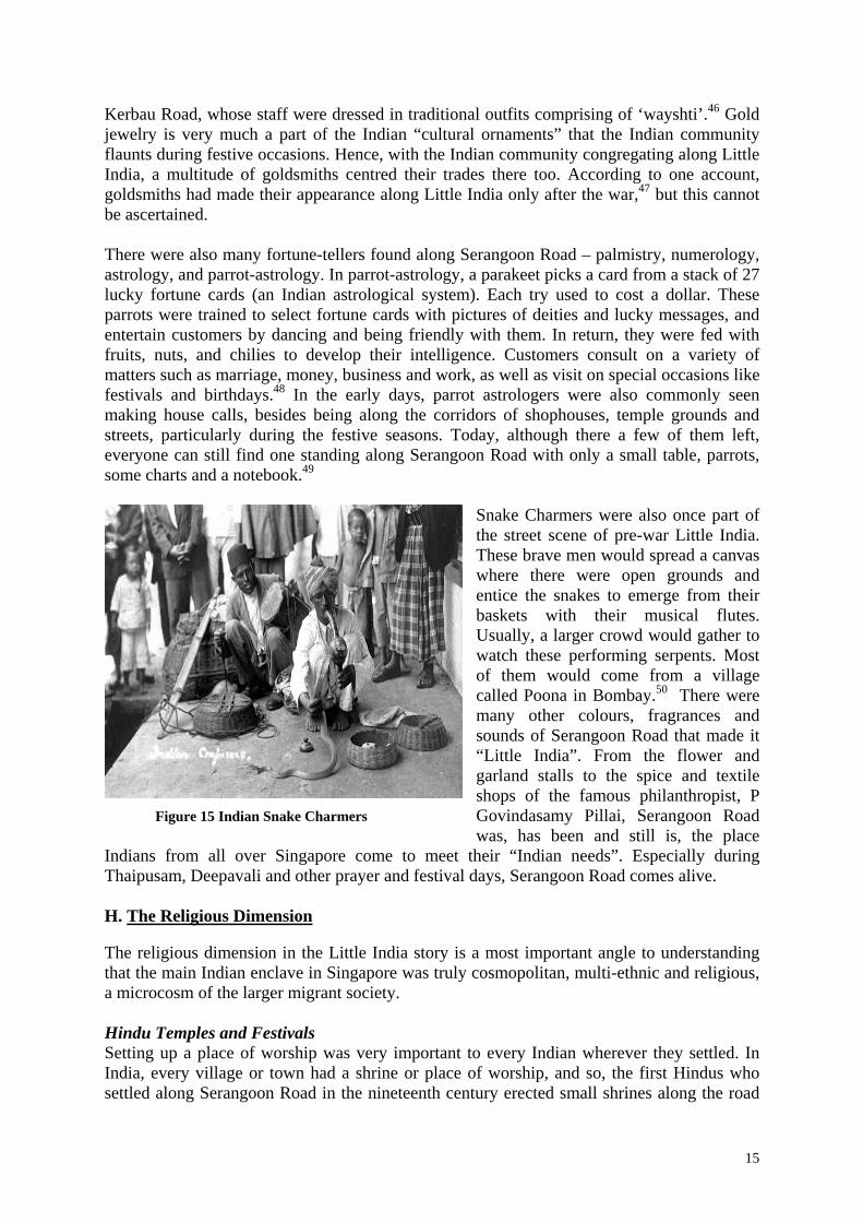
Around the years 1925 and 1926, Indian dances, dramas and folk performing arts were popular in Selegie and were performed free for the public. The actors and directors came all the way from India. The length of their performances was dependent upon their popularity reflected by the size of the crowd, thus the bigger the crowd, the longer they performed.61 Dances such as ‘Silambu’, ‘Karan’, and ‘Kalai Nigalchi’, a combination of themed dramatic art and gestures, were the favourites. Silambu is the name of the age old Indian (Tamil) art of self-defence whereby a staff (long, wooden pole) is used to defend or attack your opponents.
Figure 19 Indian Performers
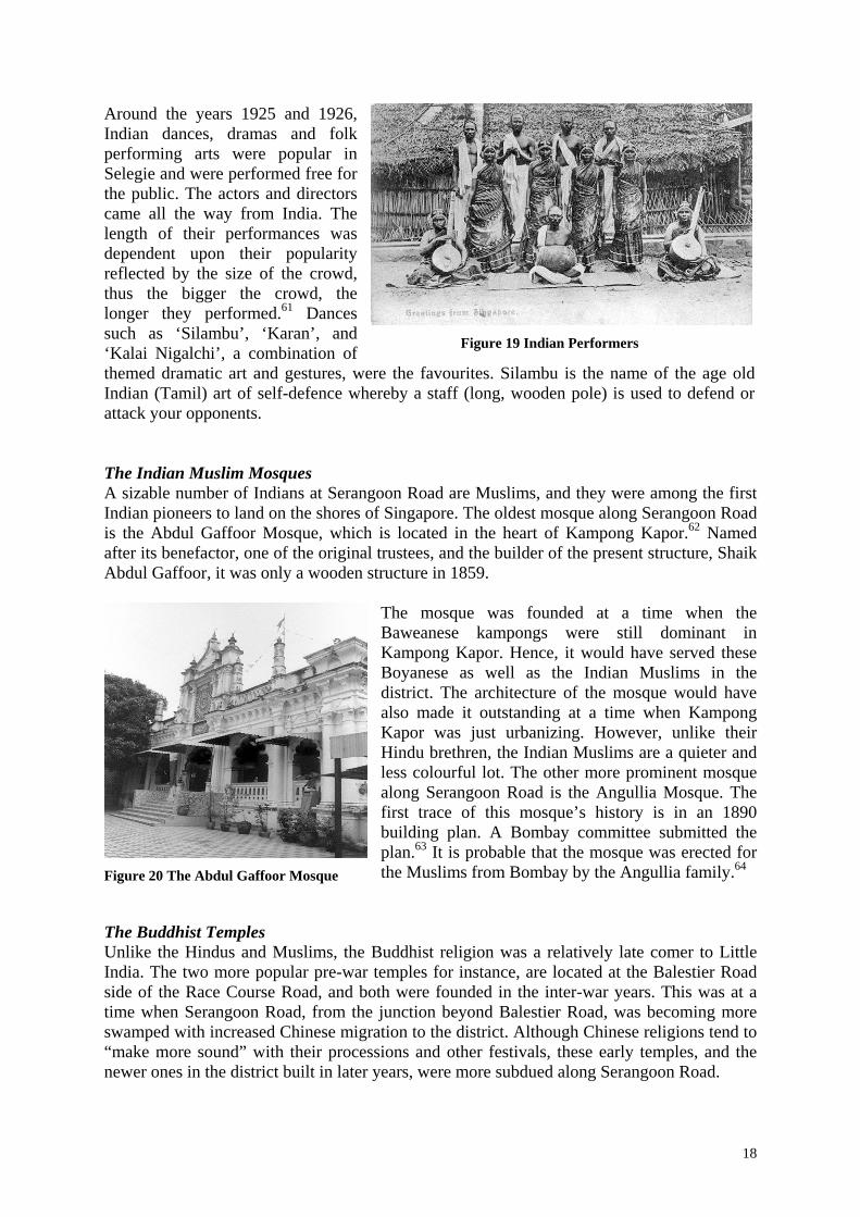
The Indian Muslim Mosques A sizable number of Indians at Serangoon Road are Muslims, and they were among the first Indian pioneers to land on the shores of Singapore. The oldest mosque along Serangoon Road is the Abdul Gaffoor Mosque, which is located in the heart of Kampong Kapor.62 Named after its benefactor, one of the original trustees, and the builder of the present structure, Shaik Abdul Gaffoor, it was only a wooden structure in 1859.
The mosque was founded at a time when the Baweanese kampongs were still dominant in Kampong Kapor. Hence, it would have served these Boyanese as well as the Indian Muslims in the district. The architecture of the mosque would have also made it outstanding at a time when Kampong Kapor was just urbanizing. However, unlike their Hindu brethren, the Indian Muslims are a quieter and less colourful lot. The other more prominent mosque along Serangoon Road is the Angullia Mosque. The first trace of this mosque’s history is in an 1890 building plan. A Bombay committee submitted the plan.63 It is probable that the mosque was erected for the Muslims from Bombay by the Angullia family.64
Figure 20 The Abdul Gaffoor Mosque
The Buddhist Temples Unlike the Hindus and Muslims, the Buddhist religion was a relatively late comer to Little India. The two more popular pre-war temples for instance, are located at the Balestier Road side of the Race Course Road, and both were founded in the inter-war years. This was at a time when Serangoon Road, from the junction beyond Balestier Road, was becoming more swamped with increased Chinese migration to the district. Although Chinese religions tend to “make more sound” with their processions and other festivals, these early temples, and the newer ones in the district built in later years, were more subdued along Serangoon Road.
18

The Leong San See, Dragon Mountain Temple, is one of the most architecturally beautiful religious building in the district. It was founded by Rev. Chuan Wu, who came from Fujian, in 1917. Chuan Wu had arrived earlier in 1913, with only an urn and a statue of Kwan Yin. He had learned the art of Chinese medication, specializing in eye treatment and cured a number of people. In 1917, the temple was called Leong San Lodge, and it consisted of only a few huts.65
Figure 21 The Leong San See
The main Buddhist festival is Vesak Day,66 and it was through the efforts of Leong San See, together with Phor Kark See, Pu Tuo See, Fa Hua See and Chiam Pok Ee, that a successful appeal was made to the government in 1956 to make Vesak Day a public holiday.67 Perhaps what is pertinent in the story of Leong San See in Little India is that, like the faiths, the temple was the gathering point for a community that was rooted to the district. It was also the institution by which this community looked to for welfare and betterment. In 1954, the priests of the temple saw the need for a school to provide education for the children living in attap houses in the surrounding area. 68 This led to the opening of the Mee Toh School, built next to the temple, in 1955. was completed and received its first batch of students. The name Mee Toh means ‘Eternal Brightness’, and it is the second Buddhist School in Singapore.69
Figure 22 The Buddha Gaya
Across the road is the Sakya Muni Buddha Gaya Temple. One of the more interesting Historic Sites in the Serangoon District, the temple has attracted visitors since it was founded in 1927 by a Thai monk named Vutthisasara.70 Perhaps, the most outstanding feature of the Sakya Muni Buddha Gaya is the 15-metre high statue of Buddha that weighs 300 tonnes. The statue is surrounded by a seemingly endless chain of lights, from which the temple derives its name, the “Temple of a Thousand Lights”. Interestingly, there are Indian monks from Sri Lanka in the temple. The Christian Churches Christian churches of various denominations and ethnicity can be found in and around Little India. Besides adding to the interesting architecture of the district’s religious buildings, they also add to the multi-ethnic character of Serangoon Road. The history of Christianity along Serangoon Road follows two lines of development; when the faith was proselytized to the Indians in the 1880s and when the improvement schemes along Serangoon Road paved the way for the Chinese to create for themselves a niche within the core Little India areas.
19

The Anglicans founded a church for their Chinese congregation at Kampong Karpor, at the junction of Dickson and Perak roads, before the war. The present Church of True Light building, however, was erected only in 1951.
The Methodist has three churches in the area; Kampong Karpor Methodist Church (KKMC), Foochow Methodist Church (FMC) and the Hing Hua Methodist Church at Kitchener Road, at the periphery of the Little India boundary. The FMC came into existence in mid-December 1897 at the Christian Institute at Middle Road, and was originally known as the Foochow Dialect Church.71 It is the second oldest church in the Chinese Annual Conference of the Methodist Church in Singapore. FMC’s first converts were poor rickshaw-riders or barbers. There was 13-14 of them and they lived around the vicinity of Victoria Street, Middle Road and Johor Road.72 The FMC shifted to Race Course Road in 1936. The history of the KKMC goes back to 1890, when a small group of about 20 Babas met at Sophia Blackmore’s house at Sophia Road. By 1930, the church had grown so large that it had to
be relocated to a larger site at Kampong Karpor. By then, the church was more Chinese than Baba.
Figure23 Kampong Karpor Methd. Church
The establishment of these churches not only brought the “western faith” to an Hindu-Muslim enclave, but also entrenched a small but close knitted Chinese community there. The Indian Christian churches, ironically, all ended up being rooted at the periphery of the Little India district. The Anglican Christ Church for instance, had its beginnings at St Peter's Church after the turn of the century, together with their Chinese brethren who went on to form the Church of True Light. The Indian congregation however, only managed to found their own church in 1940, on the other end of the Race Course (Farrer Park), at a site next to the Kandang Kerbau Maternity Hospital.
20
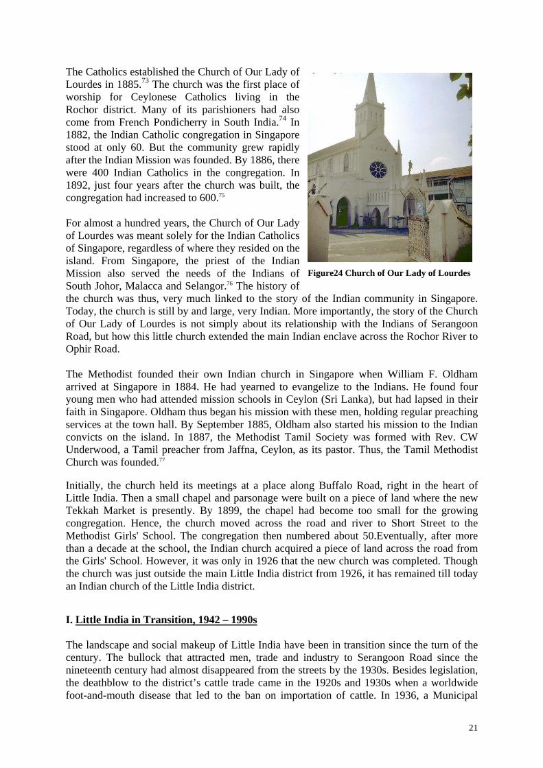
The Catholics established the Church of Our Lady of Lourdes in 1885.73 The church was the first place of worship for Ceylonese Catholics living in the Rochor district. Many of its parishioners had also come from French Pondicherry in South India.74 In 1882, the Indian Catholic congregation in Singapore stood at only 60. But the community grew rapidly after the Indian Mission was founded. By 1886, there were 400 Indian Catholics in the congregation. In 1892, just four years after the church was built, the congregation had increased to 600.75 For almost a hundred years, the Church of Our Lady of Lourdes was meant solely for the Indian Catholics of Singapore, regardless of where they resided on the island. From Singapore, the priest of the Indian Mission also served the needs of the Indians of South Johor, Malacca and Selangor.76 The history of the church was thus, very much linked to the story of the Indian community in Singapore. Today, the church is still by and large, very Indian. More importantly, the story of the Church of Our Lady of Lourdes is not simply about its relationship with the Indians of Serangoon Road, but how this little church extended the main Indian enclave across the Rochor River to Ophir Road.
Figure24 Church of Our Lady of Lourdes
The Methodist founded their own Indian church in Singapore when William F. Oldham arrived at Singapore in 1884. He had yearned to evangelize to the Indians. He found four young men who had attended mission schools in Ceylon (Sri Lanka), but had lapsed in their faith in Singapore. Oldham thus began his mission with these men, holding regular preaching services at the town hall. By September 1885, Oldham also started his mission to the Indian convicts on the island. In 1887, the Methodist Tamil Society was formed with Rev. CW Underwood, a Tamil preacher from Jaffna, Ceylon, as its pastor. Thus, the Tamil Methodist Church was founded.77
Initially, the church held its meetings at a place along Buffalo Road, right in the heart of Little India. Then a small chapel and parsonage were built on a piece of land where the new Tekkah Market is presently. By 1899, the chapel had become too small for the growing congregation. Hence, the church moved across the road and river to Short Street to the Methodist Girls' School. The congregation then numbered about 50.Eventually, after more than a decade at the school, the Indian church acquired a piece of land across the road from the Girls' School. However, it was only in 1926 that the new church was completed. Though the church was just outside the main Little India district from 1926, it has remained till today an Indian church of the Little India district. I. Little India in Transition, 1942 – 1990s The landscape and social makeup of Little India have been in transition since the turn of the century. The bullock that attracted men, trade and industry to Serangoon Road since the nineteenth century had almost disappeared from the streets by the 1930s. Besides legislation, the deathblow to the district’s cattle trade came in the 1920s and 1930s when a worldwide foot-and-mouth disease that led to the ban on importation of cattle. In 1936, a Municipal
21

Ordinance was passed to put a further check on the cattle rearing activities. This meant that cattle trade in the area had come to a near end. As a result, even more space was freed up to turn Little India into a commercial and residential hub for the Indian community. This ceaseless flow of developments, however, was diverted by a sudden turn of tide in history that brought the Rising Sun to Little India. Days of the Rising Sun Serangoon Road did not escape the horrors of war and the Occupation Years, despite the Japanese attempt to court the Indians against their British masters. When the first bombs fell on Singapore, Serangoon Road too, became a target for Japanese bombers that dominated the skies. On 8 December 1941, bombs fell on Short Street, Selegie Road and Albert Street and many people were killed or injured. Several timber yards in Prinsep Street and Albert Street went up in flames.78 The initial raids also damaged the houses along Kerbau Road and Buffalo Road. The peoples of Little India could see the planes come in three, six or nine V-shaped formations to drop their bombs.79 Houses near Hindoo Road were also damaged, but they were never rebuilt. The Tamils living along this lane fled elsewhere or back to India and the road has thence been occupied by the other ethnic groups. In many ways, the first weeks of the attack had already created the conditions for the inevitable changes that were to come in the post-war years. When the smoke cleared after all the bombing in February 1942, Singapore was already Syonan-to. During the first weeks of the Japanese Occupation, many people were gathered first at the Raffles College field for one night and then later moved into a big field at Race Course Road near Kandang Kerbau Hospital. These people were kept there for eight days and had to survive on the little rice and salt that the Japanese gave them. They cooked and ate on their own and drank water from a tap. On the eighth day, they were marched all the way from Race Course Road to Tanjong Katong Road without any lorries or supplies.80 The Sook Ching had begun.
On 18 February 1942, New World Park was one of the 28 sites used as a mass-screening centre during the Sook Ching operation to remove anti-Japanese elements within the Chinese population There were also other smaller sites of abuses. The residents of Serangoon Road, at the junction of Syed Alwi Road, were rounded up at the Siong Lim Saw Mill and Company by Japanese officials. They were told to bring a few days’ supply
of food and were made to sleep on wooden planks for four days and nights. The place was filthy with people using any space available as toilets. There was only one water pipe for a crowd of over a thousand. It was believed that the roundup was to aid the Japanese officials in getting rid of members of the volunteer forces who had served the British. 81
Figure 25 Entrance to New World Park
During the harsh days of the Occupation, many became destitute, and the religious institutions became home for some of them. The state of affairs had caused much unemployment among the Indians in the colony. Some of these found food and shelter in the temples. At the Sri Veerama Kaliamman, there were no less than 20 vagrants sleeping at the
22
temple each night. The merchants along Serangoon Road would occasionally donate rice to these vagrants.82 Nothing was repaired or developed during the Occupation, only government departments were changed. Many people died on the roadside and many were afraid to go out onto the streets because the Japanese would pull them to work at the Siam railway lines.83 Things got rough and life was tough, especially for the Chinese population in Little India. It was a common sight to see truckloads of prisoners pass along Rochor Canal Road on their way to concentration camps along Sime Road.84
The Indian community during the Occupation years was somewhat in a paradoxical situation. While many had suffered greatly during the Japanese sojourn, others had joined the cause of Chandra Bose’s Indian National Army to collaborate with the Japanese to liberate India from British Rule.85 A number of Hindus had had also joined the Indian National Army and others had left to work on the Siam-Burma railway, while others had died from poverty. 86
There is no simple answer as to the Indian’s position during the war years – collaborators or victims? A few Indian schools were established by labour unions during those dark years. The main purpose of these schools was to serve as propaganda instruments for the Indian Independence Movement in Singapore.87 Some time in 1943, the Mr. G. Maruthamuthu, an earlier trustee of the Veerama Kaliamman Temple, had decided to present a sword to General Mohan Singh, then Commander-in-Chief of the Indian National Army. The sword, made in Singapore with a silver blade and a gilt handle, was purchased by Mr Maruthamuthu himself and was supposed to be presented on the last night of the Navarathri festival in the temple in October 1943. However, General Mohan Singh was indisposed on the appointed day and sent his immediate subordinates, five high-ranking officers of the Indian National Army, instead. These officers, led by Colonel Loganathan, later Governor of the Andaman and Nicobar Islands, arranged for another presentation and also prayed to Kaliamman to help them drive Britain out of India. Before leaving the temple, they even exhorted the worshippers to pray for their success in freeing India from British rule. The presentation of the sword was eventually held in front of the City Council buildings by Mr Maruthamuthu before a large gathering of Indians and detachments of the Indian National Army.88 The Post-war Years The war came to an end in 1945 and life resumed for the people of Little India. But by then, things had changed. While commercial activities in the district continued, there were some fundamental changes. The urbanization of the district continued, but this time it was no longer driven by immigration, but by the need to repair the damage caused by the war. The post-war development of the district was also set within the backdrop of political changes in the motherland of the community, India. The War had fundamentally changed the socio-economic landscape of Little India. At the outbreak of war, many of the shop owners sold their businesses to their hired hands before they fled the island. Those who survived subsequently moved up the social ladder in the post-war era. In this instance, a greatly many more rags to riches stories were added to the history of Serangoon Road.89 However, not all the old patriarchs had disappeared altogether. P Govindasamy Pillai (PGP), an acknowledged leader of the Hindu community even before the 1940s, had five sari shops before World War II. PGP left for India in December 1941, handing his business deals to a relative. He returned after the war to continue his business in Serangoon Road. This was possible only because his business clients had trusted in him.
23

While other new proprietors were just starting to make headway with their businesses in the 1960s, PGP was already moving ahead by renovating his existing stores, which were one of the earliest sari shops in Serangoon Road. 90 Perhaps, it was because of the resilience of PGP and the other old guards of Little India that the post-war reconstruction of the Indian district could proceed. The Hindu temples of Serangoon Road had all benefited from PGP’s generosity in one-way or another. The Sri Perumal Temple, which was renovated in 1966, was still without a gopuram. It was only in 1975 that P Govindasamy Pillai donated a gopuram to the temple. Earlier in 1965, PGP financed the construction of the Kalyana Mandabam (PGP Wedding Hall) at the Perumal. Inche Yusof Bin Ishak, the Young Di Pertuan Negara, officially opened it. It was also used by several associations, including the Asian Women Welfare Association, which started off there. In those days, all Hindu marriages took place there and it was also used for lectures and speeches.91 At the Sri Veerama Kaliamman, the temple rebuilding project in 1976 was also under the patronage of the P Govindasamy Pillai.
Figure 26 PGP with his wife at the Sri Perumal
Perhaps what is pertinent in recognizing the post-war contributions of PGP and others is that the institutions that constituted the ornate and symbolic beauty of Serangoon Road, the Hindu Temples, were mostly beautified in the post-war era with the help of these philanthropists. In short, they truly helped in the construction and conception of the Little India that was to become a tourist attraction. There were still many pockets of Little India left in ruins after the war. The site on which the Gandhi Memorial was built, for instance, was a bombed out site. It might have remained so for a long time if not for the construction of the memorial.
Figure 27 The Gandhi Memorial
Besides bricks and granite, PGP and the other pioneers like Rajabali Jumabhoy,92 were also concerned with the building of a more stable Indian community in Little India. In 1950-51, an opportunity arose to bring together the Indians of Little India, as well as those throughout the island, with the arrival of India’s first Prime Minister, Jawahalal Nehru. He laid the foundation stone for the Gandhi Memorial at Race Course Lane. It cost $17,000 to build, of which, the entire amount was raised by the Indian community of Singapore, with PGP, Jumabhoy and V Packirisamy being the major contributors.93
24

The “Construction” of “Little India” In the 1960s and 1970s, when numerous Indians moved into HDB and other housing estates, Little India became primarily a commercial district that catered to the needs of the Indians throughout the island. Slum clearance of the area began in the 1970s. On 7 July 1989, Little India was gazetted a conservation area. This transitional phase of the district however, did not bring the once vibrant Indian enclave to an end. Instead, it paved the way for other developments that maintained the “Indianess” of the district. Although the migrant municipal labourers may be gone, and their past dwellings left dilapidated, occupied by non-Indians or converted into shophouses, the concentration of cultural activities can still be found there. Perhaps, this has a lot to do with the fact that the temples remained. And they have in turn, attracted businesses that support temple activities. Secondly, the district has become a “conservation hub”. Since 1989, Little India was officially recognized as the hub of Indian community life in Singapore. J. Concluding Remark For more than a century, the story of Serangoon Road's Little India revolved around a four-legged animal that the Hindus revered as sacred. Others, who conducted business, found the animal fundamentally essential as a mode of transport, or even, the source of their business ventures. But these animals would not have been there if the geography did not support their needs. Evidently, the interaction of the environment and potential commercial opportunities created a pull that led many Indian migrants to settle and work there. It was also during this period of great "pull" by Serangoon Road that there was a great "push" that in the other Indian enclaves which were left with little space to accommodate a great proliferation of Indians there. Only the ethnic enclave at Serangoon Road had room enough to absorb the increase soon after the turn of the century. Hence, a sizeable Indian community had become rooted along Serangoon Road, and with them, came a whole host of industries that supported the Indian community's cultural life. An accelerated settlement in the district necessitated urban improvement and housing schemes, and this led to the clearance of the swamp environs of Serangoon. Following this cattle rearing soon disappeared from the Serangoon scene. However, the concentration of Indian commerce, religious sites and residences in the district had already ensured that Serangoon Road would remain Indian. Yet, this overtly Indian enclave has always been cosmopolitan, multi-ethnic and religious, just like Chinatown and Kampong Glam. Though Little India was not officially designated an ethnic quarter till recent times, when efforts in conservation and tourism purposes made it so, it has always been the communal heartbeat of the Indian community. Prepared By Clement Liew
25

Endnotes 1 The information in this section was provided by Dr John Miksic October 2000. 2 Gretchen Liu, In Granite and Chunam: The National Monuments of Singapore (Landmark Books and Preservation of Monuments Board), 1996, pp.123-24. 3 Yvonne Quahe, We Remember – Cameos of Pioneer Life (Landmark Books Pte Ltd, 1986), p.12. 4 Walter Makepeace, Gilbert E. Brooke, Roland St. J. Braddell (ed), One Hundred Years of Singapore, Vol II ( Singapore: Oxford University Press, 1991), pp.344-48. 5 150th Anniversary of the Founding of Singapore, M.B.R.A.S Reprints 1973, p.122. 6 Gopal Das, “The Kaliamman Temple Serangoon Road, Singapore: A Study of the Economic and Social Position of a Hindu Temple”, Dept. of Social Studies, University of Malaya, 1958, p.17. 7 Makepeace, p.351. 8 Quahe, p.10 9 Yeo Chor Siang, “A North Indian Community in Singapore: Continuity and Change among Bihari Dairymen”, Department of Sociology, National University of Singapore, 1983/84, p.7. 10 The congregation of the Indian Catholic Church of Our Lady of Lourdes was founded in 1886 at Ophir Road, on the Rochore River, opposite Kampong Karpor. The Methodist had their Indian congregation formed at about the same time, but only moved to Short Street, near Selegie Road, in the 1920s. The Anglican Christ’s Church, having originated from St. Peter’s Church at Stamford Road in the prewar years, found its way to Kampong Java, at a site next to the Race Course, some time before the war broke out. 11 Das, “The Kaliamman Temple”, p.17. 12 In many of the oral archival accounts of Indian interviewees, deposited at the National Archives of Singapore, the area around Tanjong Pagar was considered the real “Little India”. 13 Tanjong Pagar, Singapore’s Cradle of Development (Singapore: Tanjong Pagar Constit., 1989), p.24. 14 Ray Tyres, Singapore, Then and Now, Edition 2 ( Singapore: Landmark Books, 1993), p.16. Chulia Street was constructed entirely of 2-storey buildings and was called Kling Street, after the derogatory term for imported South Indian convicts. The North Indian term for the Kalinda Kingdom is Chulia and this name prevailed. See Edwards, Norman and Peter Keys, A Guide to Buildings, Streets and Places (Singapore: Times Books International, 1988), p.451. 15 Gambier was grown together with pepper as they had formed a symbiotic agricultural relationship in the old days. Gambier leaves had to be boiled to extract the residue which were dried and exported. Hence, the needs to locate such plantations where timber are in abundance to fuel the boilers. The waste extracts of this process, the boiled leaves, would then be wasted, unless they could be recycled for another function, like becoming manure for pepper plants. 16 Edward, Guide, p.111. 17 Das, “The Kaliamman Temple”, p.19; Tyres, Singapore, p.196. 18 Buckley, Anecdotal, p.484. 19 Das, “The Kaliamman Temple”, p.19. 20 Siddique, Little India, p.27 21 Chopard, Rochore, pp.13-14. 22 Siddique, Little India, pp.33-34; Siddique, Serangoon Road, pp.18 and 36. 23 Samuel Dhoraisingam, Singapore’s Heritage through Places of Historical Interest (Singapore: Elixir Consultancy Services, 1992) p. 198; Historic Districts in the Central Area: A Manual for Little India Conservation Area (Singapore: Urban Redevelopment Authority, 1988), p.14; Little India: Historic District (Singapore: Urban Redevelopment Authority, 1995), p.15. 24 Siddique Serangoon Road, p.74; Tanjong Pagar, Singapore’s Cradle of Development (Singapore: Landmark Books, 1989), p.79; Edwards, Guide, p.128. 25 Tanjong Pagar, p.25. 26 Norman Edwards, The Singapore House and Residential Life, 1819-1939, p.56. 27 Street Names of Singapore,p.37;Straits Settlements Legislative Council Proceedings,1883,pp.210-11. 28 A Manual for Little India Conservation Area, p.12. 29 Singapore Improvement Trust Files, 1911/475. Clearly, the Muslim composition of Kampong Kapor had remained after the 1883 fire. Furthermore, the rebuilding of the village seems equally haphazard, if not worse. 30 The stretch of Serangoon Road between Dunlop Street and Rochor Canal Road was widened in 1913, presumably as part of the Kampong Kapor Improvement Scheme that started in the same period. See Minutes of Proceedings of the Municipal Council, 1913, p.80. 31 SIT, 1911/475.
26
32 Siddique, Little India, pp.60 and 76; Edwards, Guide, p.111. Despite the urban development of Serangoon Road in the prewar years, the district was still rather underdeveloped when compared to the other ethnic districts and town centre. 33 Siddique, Little India, pp.33-34. 34 Makepeace, p.351. 35 Tanjong Pagar, p.73. 36 This increase in the Indian population in Singapore may not solely be due to increased migration. A more settled community constituted of more families, which would have created a natural momentum for growth by means of birth. 37 The first Indian enclaves in Singapore were all found outside the Serangoon Road area.In many of the oral archival accounts of Indian interviewees, deposited at the National Archives of Singapore, the area around Tanjong Pagar was considered the real “Little India”. 38 Das, “The Kaliamman Temple”, p.17. 39 Oral Interview, National Archives, A000081/28 Kannusamy. Interestingly, Tamil men were also seen going from door to door selling ring flowers. These ring flowers were a common sight seen on the hair-buns of Indian women. The small flowers were sold for two cents each while the big ones were sold for fifty cents each. 40 Norman Edwards, The Singapore House and Residential Life 1819-1939, p.59. 41 Siddique, Little India, pp.35 and 45. 42 BP 1898/354, CBS 338. 43 Song Ong Siang, One Hundred Years’ of the Chinese in Singapore (Singapore: Oxford University Press, 1984), p.429. 44 Siddique, Serangoon Road, pp.93-99. 45 Oral Interview, National Archives, A000081/28 Kannusamy; A000588/13, Natesan Palanivelu. 46 Oral Interview, National Archives, A00896/4, Subbiah Bullikutte Naidu and A01170/3, Boopalan Subramaniam. 47 Oral Interview, National Archives, A000081/28 Kannusamy. 48 Vanishing Trades – A Catalogue of Oral History Interviews, Documentation Unit, Singapore: Oral History Department, 1992, pp.60-64. 49 Ibid. 50 Ibid., pp.75-79. 51 Gretchen Liu, In Granite and Chunam: The National Monuments of Singapore (Singapore: Landmark Books and Preservation of Monuments Board, 1996, p.123; http://www.heb.gov.sg/perumaltemple; Edwin Lee, Historic Buildings of Singapore (Singapore: Preservation of Monuments Board, 1990), p.76; Jean Pierre Mialaret, Hinduism in Singapore: A Guide to the Hindu Temples of Singapore (Singapore: D. Moore for Asia Pacific Press, 1969), p.59; Straits Times 10/1/82 52 Liu, Granite, p.123-24; Lee, Historic Building, p.76; Mialaret, Hinduism, p.60 53 One source states that the Sri Vadapathira Kaliamman Temple was first established around 1870 by the Hindus living in the neighbourhood. It is the third Kali temple in Singapore. See Kwang Chan Nam, “Hindu Temples in Singapore”, School of Architecture, National University of Singapore, 1983, p.72; National Archives, Oral Interview, A01306/33, Sarma Sambasiva; Mialaret, Hinduism, p.42; CBS 84, BP 260B, 1936); The Sri Veerama Kaliamman, the more well-known of the two Kaliamman temples, was built by Bengali labourers in 1881. See http://littleindia.com.sg/stb/; Mialaret, Hinduism, p.41; http://www.peraklodge.net/litindia.htm. However, certain sources have indicated that the Veerama Kaliamman began in 1835 as a simple shrine. See Dhoraisingam, p.217; Das, The Kaliamman Temple, p.42. 54 Das, The Kaliamman Temple, p.20. 55 Ibid., pp.23-24. 56 Siddique, Serangoon Road, p.92; The Straits Times Annual, 1969, S. Durai Raja Singam, ‘Day of Penance’. 57 SFP, 8 Nov 1912, p.12. 58 Malay Tribune, 27 Jan 1914, p.4. 59 Ray Tyers, Singapore Then and Now. Edition 1, Volume 2 ( Singapore: University Education Press 1976), p.356. 60 http://littleindia.com.sg/stb/ 61 Oral Interview, National Archives, A00896/7 Subbiah Bullikutte Naidu; A001300, Chandrakasan Dharmalingam; http://www.singaiinaiyam.com.sg/engevents.html. 62 Siddique, Serangoon Road, pp.49-50. 63 BP 1890/65, CBS 331. 64 The Angullias had another mosque at Angullia Park. This was built in 1933, and it was called the Angullia Mosque. See BP 1933/12, CBS 96. Till 1935, the mosque at Serangoon Road was not overtly given any name, neither Bombay nor Angullia. BP 1935/404, CBS 84. By 1954, the Serangoon mosque was also labeled the
27

Angullia Mosque on a map in the 1954 edition of the Singapore Street Directory and Guide. See Street Directory‘54, map 3. 65 Evelyn Lip, Chinese Temples in Singapore, pp.46-48 and 101; Evelyn Lip, Chinese Temples & Deities, (Singapore: Times Books International, 1986), pp.63-68; Dhoraisingam, Heritage, p.192. 66 Vesak Day celebrates the day of the Full Moon, on which Prince Siddhartha was born. 67 Lip, Temples, pp.46-48, 101; Lip, Deities, pp.63-68; Dhoraisingam, Heritage, p.192. 68 Mee Toh School Newsletter April 2000; Mee Toh School Newsletter April 2000; Mee Toh School Magazine 2000, 2000, p.20; Lip, Temples, p.68 69 Mee Toh School Magazine 2000, pp.20-21. 70 Edwards, A Guide, p.; http://littleindia.com.sg/stb/ 71 Foochow Methodist Church Centennial Celebrations – 100th Anniversary Magazine, p.19. 72 FMC Centennial, p.32. 73 The Indian Catholic congregation had actually began in 1859. It was then based at the Cathedral of the Good Shepherd. In 1867, when the Church of Sts Peter and Paul at Queen Street was founded for the Asiatic Catholics, the Indian congregation moved there. It was only in the 1880s that the Indian congregation was constituted as a Church in its own right. 74 Walter Makepeace, One Hundred Years of Singapore, Vol 2 (Singapore: Oxford University Press, 1991), p.249; Dhoraisingam, Heritage, p.204; Marjorie Doggett, Characters of Light (Singapore: Times Books International, 1985). 75 Makepeace, One Hundred Years, p.249; Compte Reudu, Bishop’s Annual Report in Clement Liew’s Missionary Journal I, 1994 1886; Clement Liew, “From Mission to Church”, NUS Hist Dept Honours Dissertation, 1993, p.58. 76 Dhoraisingam, Heritage, p.204; Compte Reudu, 1887. 77 http://web.singnet.com.sg/~sstmc/ 78 Kelly Chopard, Rochore Eyewitness (Singapore: Landmark Books for Rochore Citizen's Consultative Committee, 1989), pp.27-28. 79 Oral Interview, A000081/28 80 Oral Interview, National Archives, A000248/10, Chan Cheng Yean. 81 Oral Interview, National Archives, A00470/5, Tay Meng Hock; Historic Districts in the Central Area: A Manual for Little India Conservation Area, Urban Redevelopment Authority 1988, pp.12-14; Siddique, Little India, p.59. 82 Das, Kaliamman Temple, p.30 83 Oral Interview, A000081/28. 84 Chopard, Rochore, pp.24-26 85 In an account of the war years this author has come across in his youth, Brother William of the La Salle Brothers in Singapore recalled how the Chandra Bose had people going all over Singapore to locate every Indian to give them bananas and other food items. Bro. William, of cause, was not spared internment at Bahau in 1943 when his turn came. 86 Das, Kaliamman Temple, pp.27-28; Doraisingham, Heritage, p.217. 87 Theodore R. Doraisamy (ed), 150 Years of Education in Singapore, Teachers’ Training College 1969, p.118; Doraisingham, Heritage, p179. 88 Das, Kaliamman Temple, p.29. A Japanese sword was found by the PUB to be their possession in the 1980s. No one knew then, the origins of that sword. Could this be the INA sword? After all, the Sri Veerama Kaliamman was the temple of the municipal workers, that is, those working for the government services department. Till recent times, that job belonged to the PUB. 89 Siddique, Little India, pp.78-79. 90 “Life and Times”, TCS video cassette DS599.51 Tck.H; Doraisingham,Heritage, p.207; ST 9/8/92) 91 Ibid. 92 Jumabhoy had also fled to India when war came. There, he was the main person who fought for the cause of the evacuees from Singapore to India during WWII. In India, during the occupation years, he was a member of the Repatriation Committee in Bombay. (Who 1948, p296) He returned, like PGP, still with his wealth intact. 93 R Jumabhoy, Multiracial Singapore, 1970, pp.267-68.
28