LITTLE FIVE POINTS COMMERCIAL DISTRICT Five Points Commercial District.pdf · The Little Five...
61
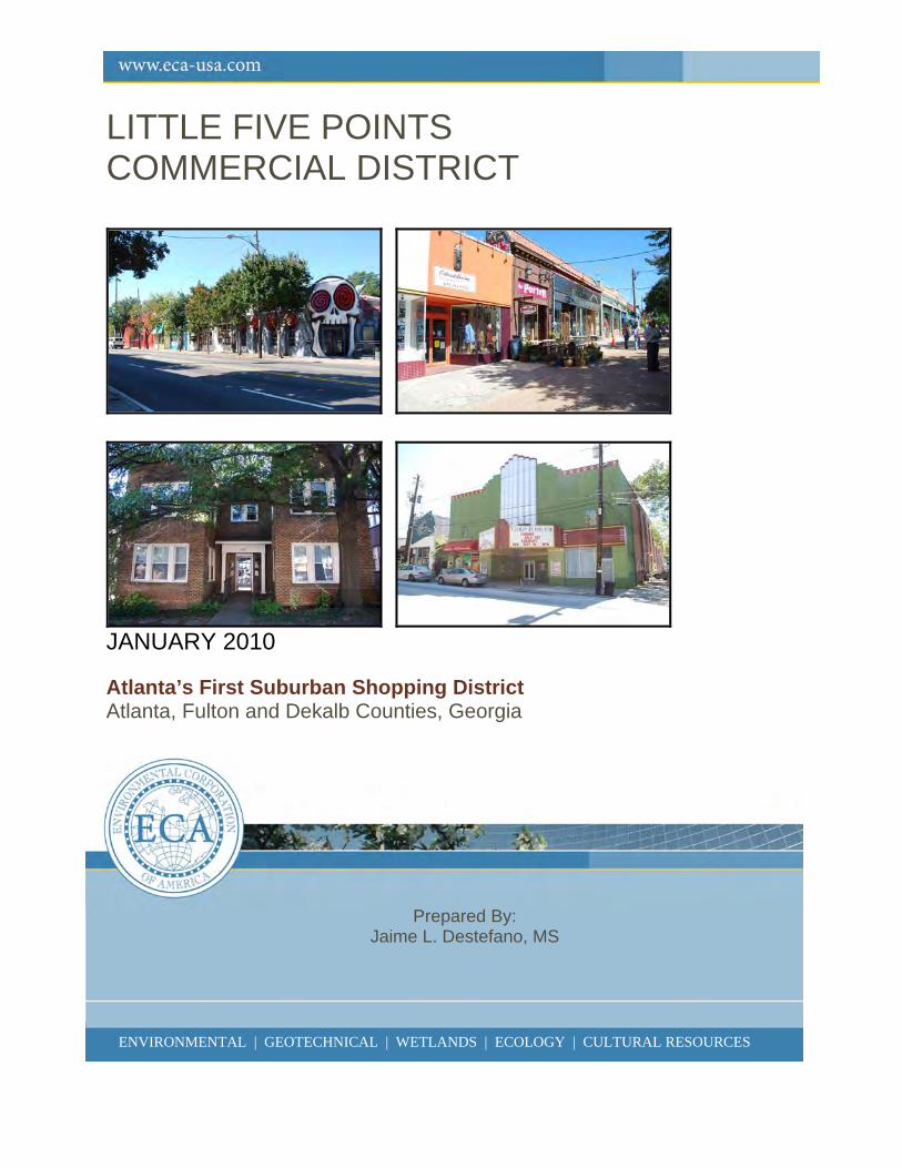
ENVIRONMENTAL | GEOTECHNICAL | WETLANDS | ECOLOGY | CULTURAL RESOURCES LITTLE FIVE POINTS COMMERCIAL DISTRICT JANUARY 2010 Atlanta’s First Suburban Shopping District Atlanta, Fulton and Dekalb Counties, Georgia Prepared By: Jaime L. Destefano, MS ENVIRONMENTAL | GEOTECHNICAL | WETLANDS | ECOLOGY | CULTURAL RESOURCES
Transcript of LITTLE FIVE POINTS COMMERCIAL DISTRICT Five Points Commercial District.pdf · The Little Five...
ENVIRONMENTAL | GEOTECHNICAL | WETLANDS | ECOLOGY | CULTURAL RESOURCES
LITTLE FIVE POINTS COMMERCIAL DISTRICT
JANUARY 2010 Atlanta’s First Suburban Shopping District Atlanta, Fulton and Dekalb Counties, Georgia
Prepared By: Jaime L. Destefano, MS
ENVIRONMENTAL | GEOTECHNICAL | WETLANDS | ECOLOGY | CULTURAL RESOURCES
ii
ENVIRONMENTAL | GEOTECHNICAL | WETLANDS | ECOLOGY | CULTURAL RESOURCES
LITTLE FIVE POINTS COMMERCIAL DISTRICT “Atlanta’s First Suburban Shopping District”
Atlanta, Fulton and Dekalb Counties, Georgia
Report Submitted To: Mittrix, Inc.
1580 Boggs Road, Suite 100 Duluth, GA 30096
and Georgia Department of Natural Resources, Historic Preservation Division
254 Washington Street SW, Ground Level Atlanta, Georgia 30334
and Fulton County Public Library
Special Collections One Margaret Mitchell Square
Atlanta, GA 30303
Report prepared by: Environmental Corporation of America, 1375 Union Hill Industrial Court
Alpharetta, Georgia 30004
___________________________ Jaime Destefano, MS
Architectural Historian and Author
January 7, 2010
ECA Project No.H-347-5 NEPA – 05015
GA HPD No. 040609-002
i
ENVIRONMENTAL | GEOTECHNICAL | WETLANDS | ECOLOGY | CULTURAL RESOURCES
ABSTRACT In June of 2009, Environmental Corporation of America was contracted by Mittrix, Inc., on behalf of T-Mobile South, LLC, to complete a developmental history of the Little Five Points Commercial District in Atlanta, Fulton County, Georgia. This research and report were completed in compliance with Section 106 of the National Historic Preservation Act of 1966. The Little Five Points commercial district is an excellent example of the city of Atlanta’s post-Civil War growth and expansion. The streetscape and surviving architectural resources within the district are indicative of Little Five Point’s development history and unique ties to the historic residential communities of East Atlanta. From the area’s early beginnings as rural farmland, to a residential area of large, Victorian estates, and later becoming the commercial and social center of the region, Little Five Points today serves as a reminder of the unique late-19th to mid-20th century evolution of the city of Atlanta.
ii
ENVIRONMENTAL | GEOTECHNICAL | WETLANDS | ECOLOGY | CULTURAL RESOURCES
TABLE OF CONTENTS
ABSTRACT........................................................................................................................................... i
TABLE OF CONTENTS...................................................................................................................... ii
LIST OF FIGURES AND TABLES.................................................................................................... iii
I. INTRODUCTION............................................................................................................................. 1
II. PROJECT AREA ............................................................................................................................. 1
III. METHODS ................................................................................................................................... 10
IV. HISTORIC CONTEXTS.............................................................................................................. 10 POST CIVIL WAR SETTLEMENT AND EARLY SUBURBANIZATION OF EAST ATLANTA...................................................................................................................................... 10 THE RISE OF ATLANTA’S FIRST REGIONAL SHOPPING DISTRICT................................. 15
V. BUILDINGS AND LANDSCAPE................................................................................................ 25 ‘TRIANGLE’ SQUARE................................................................................................................. 26 LARGE ESTATES TO MODEST FAMILY DWELLINGS: C.1880-1909.................................. 27 COMMERCIAL BOOM OF LITTLE FIVE POINTS: 1910-1935 ............................................... 33 CONTINUED DEVELOPMENT, DECLINE, AND REVITALIZATION EFFORTS: 1936-PRESENT DAY.............................................................................................................................. 40
V. REFERENCES CITED.................................................................................................................. 46
ATTACHMENTS............................................................................................................................... 49 Attachment 1: Little Five Points Inventory .................................................................................... 50 Attachment 2: Photograph Log and Proof Sheets........................................................................... 55
iii
ENVIRONMENTAL | GEOTECHNICAL | WETLANDS | ECOLOGY | CULTURAL RESOURCES
LIST OF FIGURES AND TABLES Figure 1. USGS Topographic Quadrangle Map, Northeast, Atlanta (1997) ...............................3 Figure 2. 2002 Google Aerial Photograph of Project Area and Surrounding Neighborhoods and National Register Historic Districts......................................................................4 Figure 3. Project Location and Survey Map – Contributing and Noncontributing Resources ....5 Figure 4. Project Location and Survey Map – Current Uses Map...............................................6 Figure 5. Project Location and Survey Map – Historic Uses Map ..............................................7 Figure 6. Project Location and Survey Map – Periods of Development .....................................9 Figure 7. Location of Moreland Estate and Park .......................................................................11 Figure 8. c.1880 Photograph of the Moreland Estate ................................................................12 Figure 9. Map Identifying Surviving Buildings from the Moreland Military Institute .............12 Figure 10. 1883 Georgia Map Showing Location of Edgewood.................................................13 Figure 11. Historic Photograph of Joel Hurt................................................................................13 Figure 12. Historic Photograph of Streetcar Line Crossing Moreland Bridge ............................14 Figure 13. Advertisement for the Electric Railroad and East Atlanta Land Company ...............14 Figure 14. c.1905 Photograph of the Church of the Epiphany ....................................................16 Figure 15. 1914 Photograph of the Church of the Epiphany .......................................................16 Figure 16. 1916 Photograph of the Church of the Epiphany .......................................................16 Figures 17-18. 1911 Sanborns of the Little Five Points (West of Moreland)................................18 Figures 19-20. 1911 Sanborns of Little Five Points (East of Moreland).......................................19 Figures 21-22. 1931 Sanborns of Little Five Points (North of McLendon) ..................................20 Figures 23-24. 1931 Sanborns of Little Five Points (South of McLendon) ..................................21 Figure 25. 1924 Advertisement for Foster Bros. Barber Shop ....................................................22 Figure 26. c.1940 Photograph of a Soda Fountain at 1130 Euclid Avenue.................................22 Figure 27. 2009 Bird’s Eye View of ‘Triangle’ Square ..............................................................25 Figure 28. 2009 Photograph of ‘Triangle’ Square.......................................................................25 Figure 29. 2009 Photograph of Gregory L. Davis Plaza .............................................................25 Figure 30. c.1880 Photograph of Moreland and Denny Estates ..................................................26 Figure 31. 1906 Photograph of Bealer Home and Family...........................................................27 Figure 32. 1940 Aerial View of Little Five Points Showing Moreland Estate............................27 Figure 33. 2009 Photograph of Stone Lions of Former Denny Estate ........................................28 Figure 34. 2009 Photograph of Bass Recreation Center, Formerly Moreland Park....................28 Figure 35. 2009 Photograph of Kriegshaber House, 292 Moreland Avenue...............................28 Figure 36. Photograph of 1144 Austin Avenue. ..........................................................................29 Figure 37. Photograph of 1091 Euclid Avenue ...........................................................................29 Figure 38. 2009 Photograph of The Academy, 368 Moreland Avenue.......................................30 Figure 39. 1911 Sanborn Map Showing The Academy...............................................................30 Figure 40. 1931 Sanborn Map Showing The Academy...............................................................30 Figure 41. 2009 Photograph of 1133 Euclid Avenue, the Former Moreland Military Institute Building........................................................................................................31 Figure 42. 2009 Bird’s Eye View of Little Five Points Intersection ...........................................32
iv
ENVIRONMENTAL | GEOTECHNICAL | WETLANDS | ECOLOGY | CULTURAL RESOURCES
Figure 43. 2009 Photograph of 420 Moreland Avenue ...............................................................33 Figure 44. 2009 Photograph of Point Center ...............................................................................33 Figure 45. 2009 Photograph of 1166 & 1168 Euclid Avenue .....................................................34 Figure 46. 2009 Photograph of 1147 Euclid Avenue ..................................................................34 Figure 47. 2009 Photograph of 420-426 Seminole Avnue ..........................................................34 Figure 48. 2009 Photograph of Streetscape at Euclid Avenue and ‘Triangle’ Square ................34 Figure 49. Map Identifying the Location of 3 Historic Theaters in Little Five Points ................35 Figure 50. 2009 Photograph of Seven Stages – Art Deco Theater ..............................................35 Figure 51. 2009 Photograph of Variety Playhouse – Art Deco Theater......................................35 Figure 52. 2009 Photograph of Bass Junior High School............................................................36 Figure 53. 2009 Photograph of the 1949 International-Style Bass Junior High Gym.................36 Figure 54. Former Inman Park Library, 447 Moreland Avenue..................................................36 Figure 55. 2009 Photograph of 437 Moreland Avenue (The Star Community Bar) ...................37 Figure 56. 2009 Photograph of 438 Moreland Avenue (the Vortex)...........................................37 Figure 57. 2009 Bird’s Eye View of the Oaks Apartments .........................................................37 Figure 58. 2009 Photograph of 1187 Mansfield Avenue.............................................................38 Figure 59. 2009 Photograph of 1189 McLendon Avenue ...........................................................38 Figure 60. 2009 Photograph of 483 Moreland Avenue ...............................................................38 Figure 61. 2009 Photograph of 373 Moreland Avenue ...............................................................38 Figure 62. 2009 Photograph of 451-453 Moreland Avenue........................................................39 Figure 63. 2009 Photograph of 1126 Euclid Avenue ..................................................................39 Figure 64. 2009 Photograph of 1129-1131 Euclid Avenue .........................................................39 Figure 65. 2009 Photograph of 484 Moreland Avenue ...............................................................39 Figure 66. 2009 Photograph of 468 Moreland Avenue (Junkman’s Daughter) ..........................40 Figure 67. 2009 Photograph of 467 Moreland Avenue ...............................................................40 Table 1. Breakdown of Uses of All Inventoried Resources within the Project Area.................8 Table 2. Periods of Development in the Project Area ...............................................................8 Table 3. Breakdown of Current Uses.......................................................................................24 Table 4. Breakdown of Intended Uses v. Current Uses...........................................................24 Table 5. Breakdown of the Periods of Development by Use...................................................25
1
ENVIRONMENTAL | GEOTECHNICAL | WETLANDS | ECOLOGY | CULTURAL RESOURCES
I. INTRODUCTION During the months of September and October, 2009, Environmental Corporation of America (ECA) conducted background research and a photographic documentation field survey as part of mitigation efforts related to the construction of a proposed telecommunications tower within the Little Five Points Commercial District. The photographic documentation of the Little Five Points Commercial District was conducted in accordance with “Guidelines for Establishing a Photographic Permanent Archival Record.” This written report provides a developmental history of the Project Area. A Memorandum of Agreement (FCC NEPA-05015), governing the mitigation between the Federal Communications Commission, the Georgia State Historic Preservation Officer, and T-Mobile South, LLC was finalized in September of 2008. Background research, field survey, photographic documentation and preparation of this report were conducted by ECA Architectural Historian, Ms. Jaime L. Destefano, MS. Mr. John P. McCarthy, MA, RPA, provided additional professional review of this report. Mr. McCarthy also assisted with secondary source research. Research was focused on the collection of primary and secondary documentation in order to construct a history of the development of Little Five Points in relation to the historic suburbanization of the City of Atlanta and development of East Atlanta. The district includes primarily commercial buildings, with both single- and multi-family dwellings, as well as educational facilities and theaters. Surviving resources within the Project Area are indicative of two significant periods of development: 1) post-Civil War settlement and expansion of the City of Atlanta, 2) and the early-to-mid-20th century commercial boom and the rise of Little Five Points as Atlanta’s first regional shopping district. The following report provides a detailed developmental history of the Project Area as well as an analysis of the surviving historic
resources that remain as character-defining elements of Little Five Points.
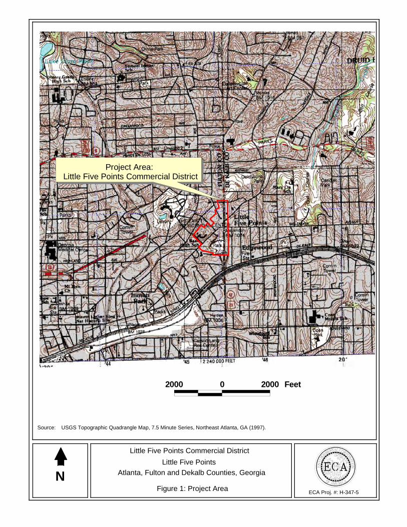
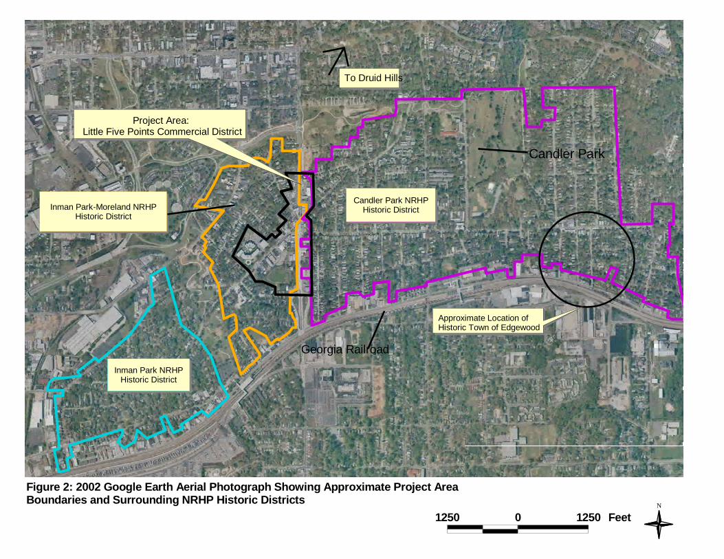
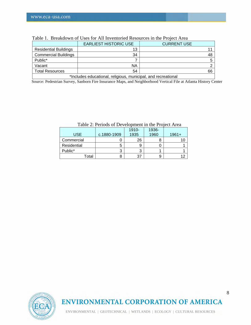
II. PROJECT AREA The Little Five Points Commercial District is situated along Moreland and Euclid Avenues at the Little Five Points intersection in northeast Atlanta (Figure 1). Portions of Little Five Points are included in the National Register-listed Inman Park-Moreland Historic District and the Candler Park Historic District (Figure 2). Resources within the Project Area were evaluated as contributing and non-contributing based on their ability to contribute to the character and historic fabric of a potential National Register Historic District - Little Five Points Commercial District. Incorporating approximately 38 acres and 66 resources (54 contributing/12 noncontributing) (Figure 3), the Little Five Points Commercial District survives as an example of one of the south’s first suburban shopping districts where small businesses met the commercial needs of the surrounding suburban neighborhoods that developed in the late-19th and early-20th century (Anderson and Dolder 2003). The center of Little Five Points is located at the convergence of three major roads: Moreland Avenue (once called Hurts Avenue and County Line Road), Euclid Avenue (formerly Decatur Turnpike or the “Pike”), and Seminole Avenue (formerly Cleburne Avenue) (Figures 1 & 2). Moreland Avenue runs through the center of the Commercial District and also serves as the county line separating Fulton County to the west and Dekalb County to the east. Euclid Avenue runs southwest to northeast through the center of the district. McClendon Avenue runs eastward from Euclid just south of the Little Five Points intersection.
The Project Area primarily includes all properties fronting Moreland Avenue north of Austin Avenue
2
ENVIRONMENTAL | GEOTECHNICAL | WETLANDS | ECOLOGY | CULTURAL RESOURCES
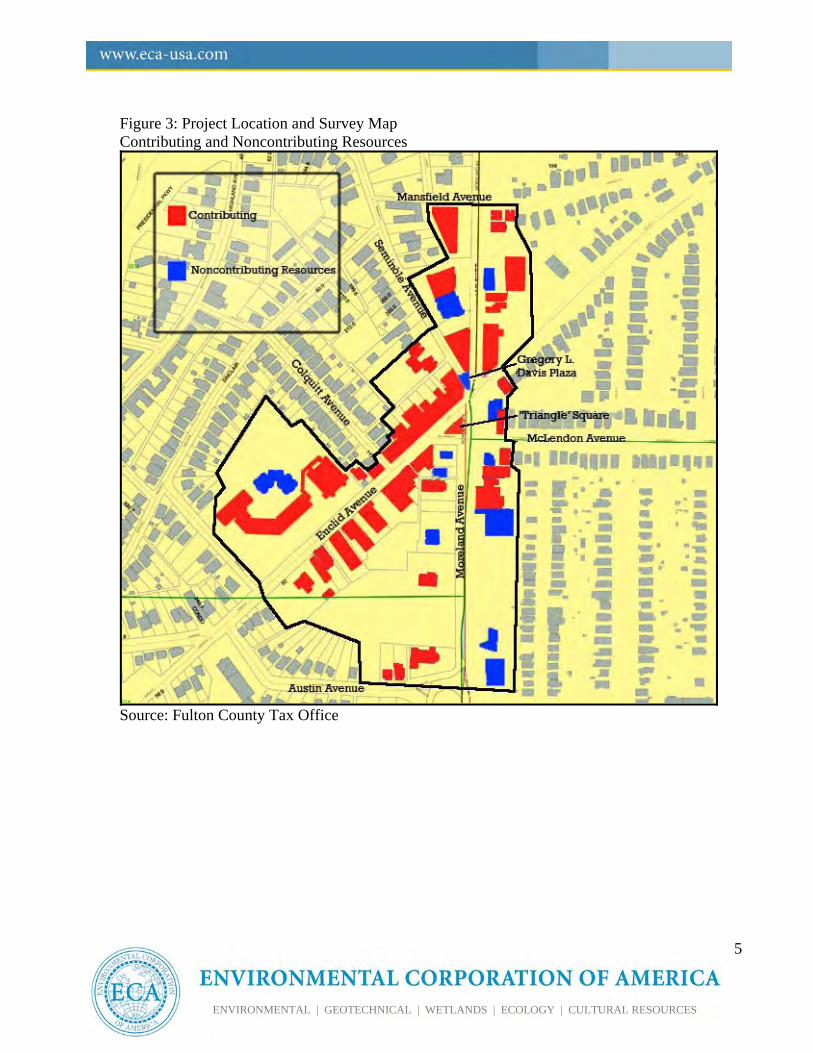
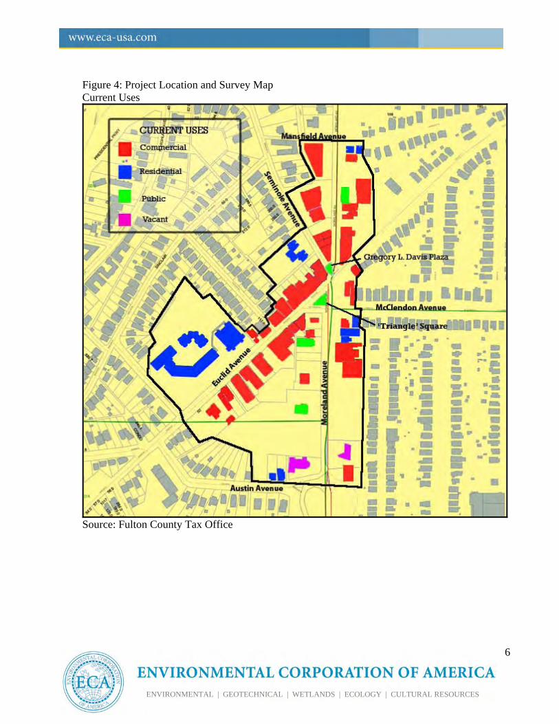
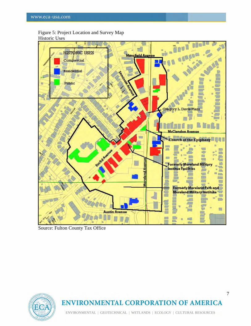
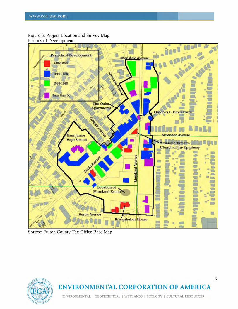
to Mansfield Avenue as well as properties fronting Euclid Avenue northeast of Austin Avenue to Moreland Avenue. Figures 1 to 3 identify the Project Area in three different formats: topographic map, an aerial identifying nearby neighborhoods and National Register boundaries, and a survey map identifying building outlines and contributing and noncontributing resources. The Project Area contains a total of 66 resources primarily having commercial uses. Two public spaces, ‘Triangle’ Square and Gregory L. Davis Plaza. The former is found to be contributing to the historic character of the commercial district. A Georgia Landmark, the Kriegshaber House, located at 292 Moreland Avenue, was also found to be located within the Project Area. The historic and current use of each resource is identified in Figures 4 and 5. Table 1 includes categorized uses for both historic and current time periods. During the field survey, only two buildings were found to be entirely vacant (Figure 4). In addition, of the commercial buildings with multiple business space, only a minimal number of storefronts appeared to be unoccupied. Dates of construction for contributing commercial buildings range between 1910 and 1960 with the highest concentration of development having taken place during the 1920s (Table 2). Dates of construction for the contributing residential structures, both single- and multi- family dwellings, range between 1880 and 1939. All of the surviving resources serve as reminders to the development of Little Five Points commercial district and its transition from farmland to residential (late 19th-century) and from residential to commercial during the early-20th century. The Little Five Points commercial district is extremely pedestrian friendly, with the majority of the streets within the project area being lined with narrow sidewalks and landscaping. Surrounding the Little Five Points intersection, west of Moreland Avenue, the ‘triangle’ park and Gregory
L. Davis Plaza feature benches, tables and lampposts. Today, these spaces are often filled with people relaxing and enjoying live music. A public park is located between Euclid and Moreland and Austin Avenues.
Project Area: Little Five Points Commercial District
2000 0 2000 Feet
N
Source: USGS Topographic Quadrangle Map, 7.5 Minute Series, Northeast Atlanta, GA (1997).
ECA Proj. #: H-347-5
Little Five Points Commercial District
Little Five Points
Atlanta, Fulton and Dekalb Counties, Georgia
Figure 1: Project Area
#
Georgia Railroad
#
Candler Park
Project Area: Little Five Points Commercial District
Inman Park-Moreland NRHPHistoric District
Inman Park NRHPHistoric District
Candler Park NRHPHistoric District
To Druid Hills
Approximate Location ofHistoric Town of Edgewood
1250 0 1250 FeetN
Figure 2: 2002 Google Earth Aerial Photograph Showing Approximate Project Area Boundaries and Surrounding NRHP Historic Districts
5
ENVIRONMENTAL | GEOTECHNICAL | WETLANDS | ECOLOGY | CULTURAL RESOURCES
Figure 3: Project Location and Survey Map Contributing and Noncontributing Resources
Source: Fulton County Tax Office
6
ENVIRONMENTAL | GEOTECHNICAL | WETLANDS | ECOLOGY | CULTURAL RESOURCES
Figure 4: Project Location and Survey Map Current Uses
Source: Fulton County Tax Office
7
ENVIRONMENTAL | GEOTECHNICAL | WETLANDS | ECOLOGY | CULTURAL RESOURCES
Figure 5: Project Location and Survey Map Historic Uses
Source: Fulton County Tax Office
8
ENVIRONMENTAL | GEOTECHNICAL | WETLANDS | ECOLOGY | CULTURAL RESOURCES
Table 1. Breakdown of Uses for All Inventoried Resources in the Project Area
EARLIEST HISTORIC USE CURRENT USE Residential Buildings 13 11Commercial Buildings 34 48Public* 7 5Vacant NA 2 Total Resources 54 66
*Includes educational, religious, municipal, and recreational Source: Pedestrian Survey, Sanborn Fire Insurance Maps, and Neighborhood Vertical File at Atlanta History Center
Table 2: Periods of Development in the Project Area
USE c.1880-1909 1910-1935
1936-1960 1961+
Commercial 0 26 8 10 Residential 5 9 0 1 Public* 3 3 1 1
Total 8 37 9 12
9
ENVIRONMENTAL | GEOTECHNICAL | WETLANDS | ECOLOGY | CULTURAL RESOURCES
Figure 6: Project Location and Survey Map Periods of Development
Source: Fulton County Tax Office Base Map
10
ENVIRONMENTAL | GEOTECHNICAL | WETLANDS | ECOLOGY | CULTURAL RESOURCES
III. METHODS Research Research of the Little Five Points Commercial District began with obtaining National Register nominations and supporting documentation associated with the developmental history of Little Five Points. An examination of the neighborhood vertical files at the Atlanta History Center provided substantial information pertaining to the history of Little Five Points. Examination of tax parcel data available at the Fulton County Tax Commissioner’s Office offered approximate build dates and useful data for each property located within the Project Area. The Deeds and Records Office at the Fulton County Courthouse identified several early-20th century plats of the project area. The Atlanta-Fulton County Public Library yielded additional general background information from published secondary resources. Survey On September 27, 2009, Jaime Destefano, project manager and architectural historian with Environmental Corporation of America conducted field work to produce photographic documentation in accordance with the “Georgia Guidelines for Establishing a Photographic Permanent Archival Record.” During the photo-documentation survey, Ms. Destefano conducted a pedestrian survey of the Little Five Points Commercial District project area to document its architectural character and general design and setting of the streetscapes.
IV. HISTORIC CONTEXTS The Little Five Points commercial district underwent considerable transformations following the Civil War. Improvements in transportation and entrepreneurial real estate interests sparked the
suburban development surrounding Atlanta’s central business district as early as the 1870s. Following the Civil War, the Little Five Points area underwent two significant periods of development. The first period includes post-Civil War settlement and the early suburbanization of East Atlanta, including that of the Little Five Points area. The second significant developmental period, is the rise of Little Five Points as a central commercial district for East Atlanta neighborhoods. Both periods are reflective of the rapid growth of Atlanta and expansion beyond the early city limits.
POST CIVIL WAR SETTLEMENT AND EARLY SUBURBANIZATION OF EAST ATLANTA Development of the Little Five Points commercial district is closely tied to the complex pattern of development evolving in the regions east of Atlanta as early as the 1870s. These regions make up what would later be referred to as Edgewood/Candler Park (located east of the county line in Dekalb County) and Inman Park (the regions west of Moreland Avenue and southwest of Edgewood). The subdivision of large tracts of land into a single neighborhood was typical of Atlanta’s late-19th and early-20th century suburbanization (Anderson and Dolder 2003: 10). The development of Little Five Points began in much the same way. Once part of a large rural farming estate and Civil War Battlefield, the area which was to become Little Five Points, began its initial development during this period as large tracts of land east of the city were subdivided into parcels to accommodate large, residential estates (NPS ND). Throughout the 1890s and early 1900s, new residential districts emerged as old farms on the outskirts of the city “were rapidly carved up into fashionable ‘garden suburbs’” such as Inman Park, Ansley Park, and Candler Park (NPS ND).
11
ENVIRONMENTAL | GEOTECHNICAL | WETLANDS | ECOLOGY | CULTURAL RESOURCES
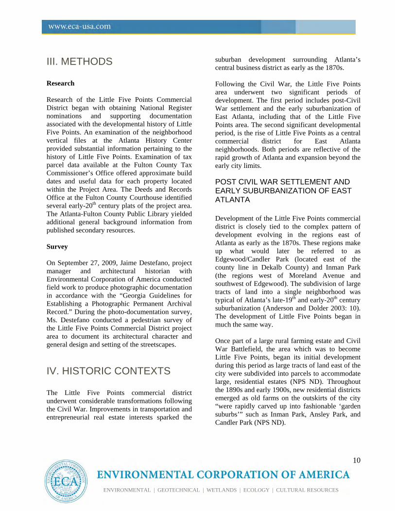
As early as the 1850s, August F. Hurt began purchasing large tracts of the land in regions east of Atlanta’s central business district. The Little Five Points Commercial District remained rural farmland until the 1870s when “East Atlanta” began its transition from rural to residential. The development of the area which would later become Little Five Points began as a result of two significant land subdivisions: 1) the subdivision of large tracts of land by Major Asbury Moreland and 2) the growth of the City of Edgewood. This first significant transition began in 1869 when Major Asbury Moreland of the 7th Alabama Cavalry purchased twelve acres of land surrounding County Line Road (now Moreland Avenue) and Pike Road (now Euclid Avenue) from Joel Hurt, descendent of August F. Hurt (Pittman 1985: 10). It is around this intersection that the Little Five Points commercial district would later develop. The property acquisition by Major Moreland and his subsequent subdivision of it marked one of the first significant changes in the region from traditionally rural farmland to residential development. As a result of Major Moreland’s land subdivision, large estates began to emerge in the vicinity of the Little Five Points intersection including his own family estate. Major Moreland built a large Italianate brick home, barn and stables on Moreland Avenue in 1872. In a deep ravine behind his home, he created a small park and pond known as Moreland Park, bounded by Austin, Moreland, and Euclid Avenues (Figure 7) (Jordan 1977: 11). The Moreland house and park were illustrative of a period of landscape architecture in the area in which large estates were developed and settled (Figure 8). Due to subdivision of tracts of Major Morland’s land, by the 1880s, Moreland Park was considered a summer retreat for city dwellers who could rent rooms in the grand homes that had been erected
surrounding the park and the Little Five Points vicinity (Pittman 1985: 11).
Figure 7: Location of the Moreland Estate and Park. The building shaded red was the former Moreland residence. The buildings shaded gray were constructed in later years. In 1886, Major Moreland donated some of his land, including Moreland Park, to the Georgia Military Academy. The school later changed its name to the Moreland Military Institute (Jordan 1977: 11). According to a 1977 newspaper article, two of the school’s buildings survive: one forming the rear of the current Masonic Lodge (368 Moreland Avenue) and the other forming the rear of 1133 Euclid Avenue, Parcel Number 0013-045 (Figure 9, Photographs 042-043 & 078-079). The same source indicated that the current Masonic Lodge building became Neel’s Academy in 1890, and later the first Moreland Public School.
12
ENVIRONMENTAL | GEOTECHNICAL | WETLANDS | ECOLOGY | CULTURAL RESOURCES
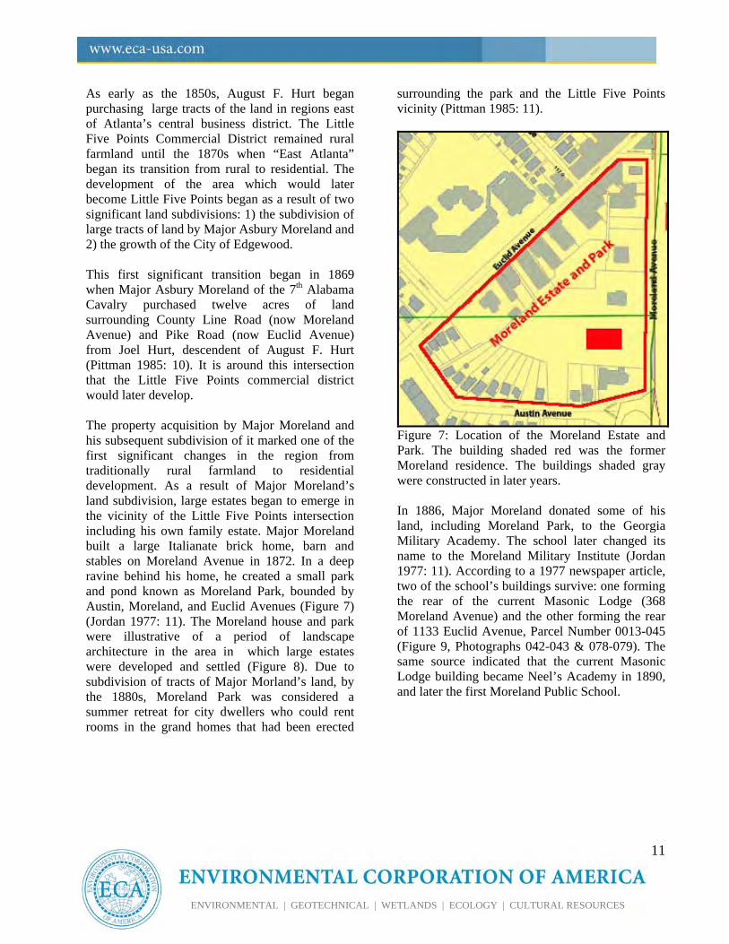
Figure 8: The Moreland Estate c. 1880 and the Fine Estates Along Moreland Avenue The Moreland home was demolished in the 1920s and the park is currently utilized for athletic fields. Courtesy of Atlanta History Center
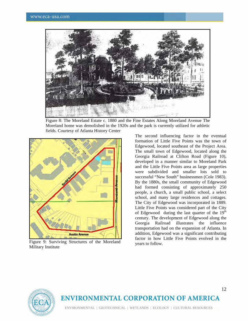
Figure 9: Surviving Structures of the Moreland Military Institute
The second influencing factor in the eventual formation of Little Five Points was the town of Edgewood, located southeast of the Project Area. The small town of Edgewood, located along the Georgia Railroad at Clifton Road (Figure 10), developed in a manner similar to Moreland Park and the Little Five Points area as large properties were subdivided and smaller lots sold to successful “New South” businessmen (Cole 1983). By the 1880s, the small community of Edgewood had formed consisting of approximately 250 people, a church, a small public school, a select school, and many large residences and cottages. The City of Edgewood was incorporated in 1889. Little Five Points was considered part of the City of Edgewood during the last quarter of the 19th century. The development of Edgewood along the Georgia Railroad illustrates the influence transportation had on the expansion of Atlanta. In addition, Edgewood was a significant contributing factor in how Little Five Points evolved in the years to follow.
13
ENVIRONMENTAL | GEOTECHNICAL | WETLANDS | ECOLOGY | CULTURAL RESOURCES
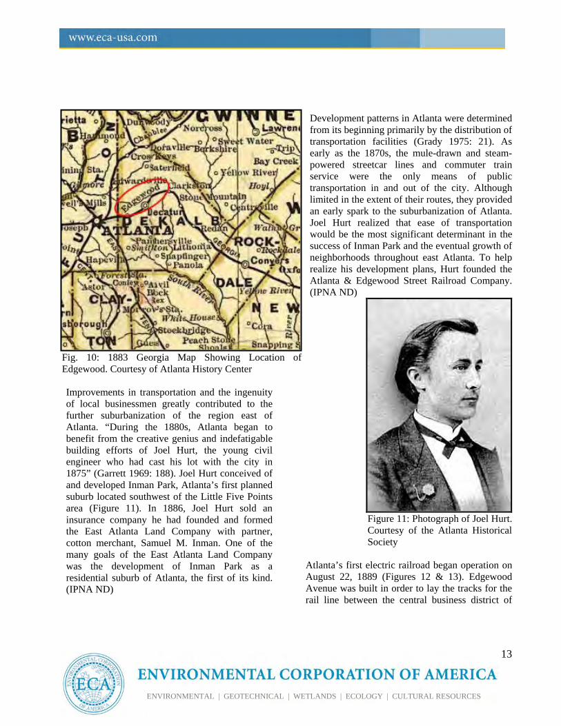
Fig. 10: 1883 Georgia Map Showing Location of Edgewood. Courtesy of Atlanta History Center Improvements in transportation and the ingenuity of local businessmen greatly contributed to the further suburbanization of the region east of Atlanta. “During the 1880s, Atlanta began to benefit from the creative genius and indefatigable building efforts of Joel Hurt, the young civil engineer who had cast his lot with the city in 1875” (Garrett 1969: 188). Joel Hurt conceived of and developed Inman Park, Atlanta’s first planned suburb located southwest of the Little Five Points area (Figure 11). In 1886, Joel Hurt sold an insurance company he had founded and formed the East Atlanta Land Company with partner, cotton merchant, Samuel M. Inman. One of the many goals of the East Atlanta Land Company was the development of Inman Park as a residential suburb of Atlanta, the first of its kind. (IPNA ND)
Development patterns in Atlanta were determined from its beginning primarily by the distribution of transportation facilities (Grady 1975: 21). As early as the 1870s, the mule-drawn and steam-powered streetcar lines and commuter train service were the only means of public transportation in and out of the city. Although limited in the extent of their routes, they provided an early spark to the suburbanization of Atlanta. Joel Hurt realized that ease of transportation would be the most significant determinant in the success of Inman Park and the eventual growth of neighborhoods throughout east Atlanta. To help realize his development plans, Hurt founded the Atlanta & Edgewood Street Railroad Company. (IPNA ND)
Figure 11: Photograph of Joel Hurt. Courtesy of the Atlanta Historical Society
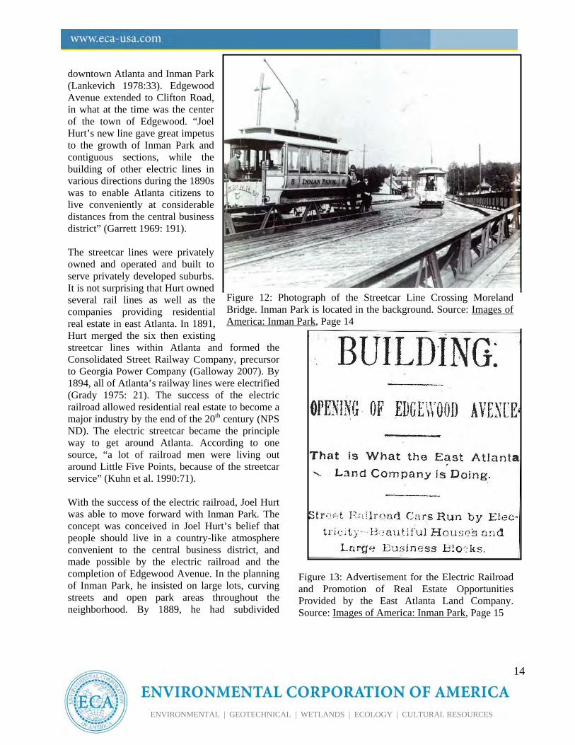
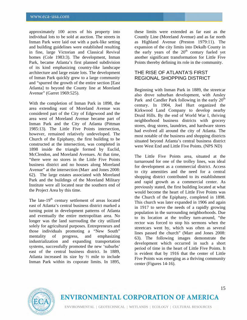
Atlanta’s first electric railroad began operation on August 22, 1889 (Figures 12 & 13). Edgewood Avenue was built in order to lay the tracks for the rail line between the central business district of
14
ENVIRONMENTAL | GEOTECHNICAL | WETLANDS | ECOLOGY | CULTURAL RESOURCES
downtown Atlanta and Inman Park (Lankevich 1978:33). Edgewood Avenue extended to Clifton Road, in what at the time was the center of the town of Edgewood. “Joel Hurt’s new line gave great impetus to the growth of Inman Park and contiguous sections, while the building of other electric lines in various directions during the 1890s was to enable Atlanta citizens to live conveniently at considerable distances from the central business district” (Garrett 1969: 191). The streetcar lines were privately owned and operated and built to serve privately developed suburbs. It is not surprising that Hurt owned several rail lines as well as the companies providing residential real estate in east Atlanta. In 1891, Hurt merged the six then existing streetcar lines within Atlanta and formed the Consolidated Street Railway Company, precursor to Georgia Power Company (Galloway 2007). By 1894, all of Atlanta’s railway lines were electrified (Grady 1975: 21). The success of the electric railroad allowed residential real estate to become a major industry by the end of the 20th century (NPS ND). The electric streetcar became the principle way to get around Atlanta. According to one source, “a lot of railroad men were living out around Little Five Points, because of the streetcar service” (Kuhn et al. 1990:71). With the success of the electric railroad, Joel Hurt was able to move forward with Inman Park. The concept was conceived in Joel Hurt’s belief that people should live in a country-like atmosphere convenient to the central business district, and made possible by the electric railroad and the completion of Edgewood Avenue. In the planning of Inman Park, he insisted on large lots, curving streets and open park areas throughout the neighborhood. By 1889, he had subdivided
Figure 13: Advertisement for the Electric Railroad and Promotion of Real Estate Opportunities Provided by the East Atlanta Land Company. Source: Images of America: Inman Park, Page 15
Figure 12: Photograph of the Streetcar Line Crossing Moreland Bridge. Inman Park is located in the background. Source: Images of America: Inman Park, Page 14
15
ENVIRONMENTAL | GEOTECHNICAL | WETLANDS | ECOLOGY | CULTURAL RESOURCES
approximately 100 acres of his property into individual lots to be sold at auction. The streets in Inman Park were laid out with a park-like setting and building guidelines were established resulting in fine, large Victorian and Classical Revival homes (Cole 1983:3). The development, Inman Park, became Atlanta’s first planned subdivision of its kind emphasizing country-like landscape architecture and large estate lots. The development of Inman Park quickly grew to a large community and “spurred the growth of the entire section [East Atlanta] to beyond the County line at Moreland Avenue” (Garret 1969:525). With the completion of Inman Park in 1898, the area extending east of Moreland Avenue was considered part of the City of Edgewood and the area west of Moreland Avenue became part of Inman Park and the City of Atlanta (Pittman 1985:13). The Little Five Points intersection, however, remained relatively undeveloped. The Church of the Epiphany, the first building to be constructed at the intersection, was completed in 1898 inside the triangle formed by Euclid, McClendon, and Moreland Avenues. At that time, “there were no stores in the Little Five Points business district and no houses along Moreland Avenue” at the intersection (Marr and Jones 2008: 62). The large estates associated with Moreland Park and the buildings of the Moreland Military Institute were all located near the southern end of the Project Area by this time. The late-19th century settlement of areas located east of Atlanta’s central business district marked a turning point in development patterns of Atlanta and eventually the entire metropolitan area. No longer was the land surrouding the city utilized solely for agricultural purposes. Entrepreneurs and those individuals promoting a “New South” mentality of progress, and emphasizing industrialization and expanding transportation systems, successfully promoted the new ‘suburbs’ east of the central business district. In 1889, Atlanta increased its size by ½ mile to include Inman Park within its coporate limits. In 1895,
these limits were extended as far east as the Countly Line (Moreland Avenue) and as far north as Highland Avenue (Preston 1979:11). The expansion of the city limits into Dekalb County in the early years of the 20th century fueled yet another significant transformation for Little Five Points thereby defining its role in the community.
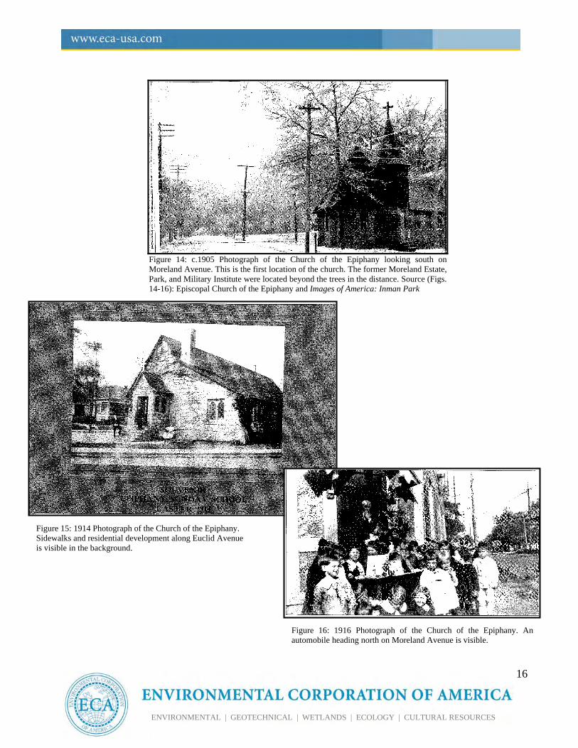
THE RISE OF ATLANTA’S FIRST REGIONAL SHOPPING DISTRICT Beginning with Inman Park in 1889, the streetcar also drove suburban development, with Ansley Park and Candler Park following in the early 20th century. In 1904, Joel Hurt organized the Kirkwood Land Company to develop nearby Druid Hills. By the end of World War I, thriving neighborhood business districts with grocery stores, drug stores, laundries, and hardware stores had evolved all around the city of Atlanta. The most notable of the business and shopping districts situated beyond Atlanta’s central business district were West End and Little Five Points. (NPS ND) The Little Five Points area, situated at the turnaround for one of the trolley lines, was ideal for development as a commercial district. Access to city amenities and the need for a central shopping district contributed to its establishment and rapid growth as a commercial center. As previously stated, the first building located at what would become the heart of Little Five Points was the Church of the Epiphany, completed in 1898. This church was later expanded in 1906 and again in 1917 to serve the needs of a rapidly growing population in the surrounding neighborhoods. Due to its location at the trolley turn-around, “the rector was forced to stop his sermons when the streetcars went by, which was often as several lines passed the church” (Marr and Jones 2008: 63). The following images demonstrate the development which occurred in such a short period of time in the heart of Little Five Points. It is evident that by 1916 that the center of Little Five Points was emerging as a thriving community center (Figures 14-16).
16
ENVIRONMENTAL | GEOTECHNICAL | WETLANDS | ECOLOGY | CULTURAL RESOURCES
Figure 14: c.1905 Photograph of the Church of the Epiphany looking south on Moreland Avenue. This is the first location of the church. The former Moreland Estate, Park, and Military Institute were located beyond the trees in the distance. Source (Figs. 14-16): Episcopal Church of the Epiphany and Images of America: Inman Park
Figure 15: 1914 Photograph of the Church of the Epiphany. Sidewalks and residential development along Euclid Avenue is visible in the background.
Figure 16: 1916 Photograph of the Church of the Epiphany. An automobile heading north on Moreland Avenue is visible.
17
ENVIRONMENTAL | GEOTECHNICAL | WETLANDS | ECOLOGY | CULTURAL RESOURCES
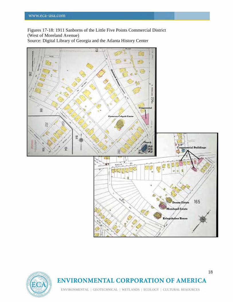
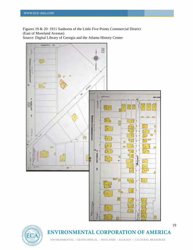
The City of Edgewood struggled during the early years of the 20th century and petitioned for its annexation into the city of Atlanta following the Banker’s Panic of 1907 (Pittman 1985: 13).1 With its official annexation in 1909, Atlanta now extended its limits into Dekalb County to include Edgewood.2 The City quickly invested in municipal improvement of streets, water, gas, and sewer systems. The community of Edgewood expanded northward, eventually merging with the developing Candler Park, as streetcar lines extended onto Moreland, McLendon, and Euclid Avenues (Cole 1983: 5; Pittman 1985: 13). The trolley lines servicing these new suburban neighborhoods converged at the Little Five Points intersection. With the annexation of Edgewood, improvements in transportation routes, and the rapid suburbanization of the surrounding area, Little Five Points began its second major transitional period-from large residential estates to into a central commercial district. The need for a central neighborhood shopping and business district to serve the surrounding neighborhoods was evident. An influx of people quickly purchased lots in and around Little Five Points during the early years of the 20th century. The death of Major Asbury Moreland in 1909 further propelled the development boom of the Little Five Points area as the remainder of his property was further subdivided and sold off (Pittman 1985:11). Smaller Bungalows, Folk Victorian and American Four-Square homes replaced the large estates of the late-19th century along Euclid and Moreland Avenues northward towards the Little Five Points intersection (Figures 17-20). Several of these early-20th century residences from the Moreland land subdivision located at the southern end of Euclid Avenue near Austin
1 Bank panic and falling stock market occurring between May 1907 and June 1908 as measured by the National Bureau of Economic Research 2 Some sources indicate an annexation date of 1908.
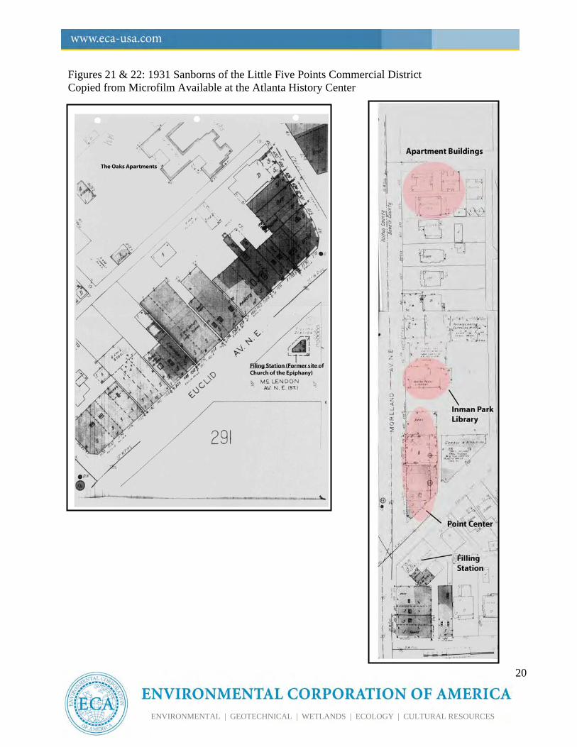
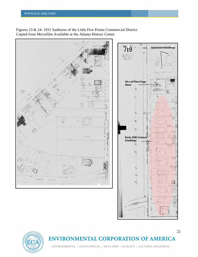
Avenue survive.3 As the residential neighborhoods around Little Five Points grew, the pressure for a neighborhood commercial district mounted. As a result, the majority of the residential buildings situated along Euclid and Moreland Avenues around the intersection were either converted to commercial uses or removed and replaced with commercial buildings. The following Sanborn Fire Insurance Map images from 1911 and 1931 confirm the rapid development of a commercial center in a relatively short span of time (Figures 17-24). The first commercial business opened in Little Five Points on Euclid Avenue in 1910 (Cole 1983: 10). In 1922, Little Five Points was officially zoned as a business district and “by 1928, all of the commercial buildings in the district had been constructed (Cole 1983: 4).” The last of the commercial buildings constructed during this commercial boom period is Point Center, located at the northeast quadrant of the intersection of Moreland and Euclid Avenues. This building served as the first suburban office of the Georgia Power Company (Pittman 1985: 14). A 1927 Atlanta Constitution article refers to Little Five Points as “Atlanta’s most progressive community center.” The same article mentions the opening of a “white way” street lighting system throughout the district as well as new automobile service station – Ginn Battery and Tire. According to Marr and Jones, “Little Five Points grew to distinction as the largest regional shopping district of the era due to the intersection of three streetcar lines, and profit-minded builders” (Marr and Jones 2008: 69). Serving the surrounding neighborhoods, Little Five Points offered a variety of shopping and entertainment opportunities, and services including filling stations, auto repair, drugstores, barbers, etc.
3 These dwellings are not located within the project area as they are considered to be associated with Inman Park and not the commercial district of Little Five Points.
18
ENVIRONMENTAL | GEOTECHNICAL | WETLANDS | ECOLOGY | CULTURAL RESOURCES
Figures 17-18: 1911 Sanborns of the Little Five Points Commercial District (West of Moreland Avenue) Source: Digital Library of Georgia and the Atlanta History Center
19
ENVIRONMENTAL | GEOTECHNICAL | WETLANDS | ECOLOGY | CULTURAL RESOURCES
Figures 19 & 20: 1911 Sanborns of the Little Five Points Commercial District (East of Moreland Avenue) Source: Digital Library of Georgia and the Atlanta History Center
20
ENVIRONMENTAL | GEOTECHNICAL | WETLANDS | ECOLOGY | CULTURAL RESOURCES
Figures 21 & 22: 1931 Sanborns of the Little Five Points Commercial District Copied from Microfilm Available at the Atlanta History Center
21
ENVIRONMENTAL | GEOTECHNICAL | WETLANDS | ECOLOGY | CULTURAL RESOURCES
Figures 23 & 24: 1931 Sanborns of the Little Five Points Commercial District Copied from Microfilm Available at the Atlanta History Center
22
ENVIRONMENTAL | GEOTECHNICAL | WETLANDS | ECOLOGY | CULTURAL RESOURCES
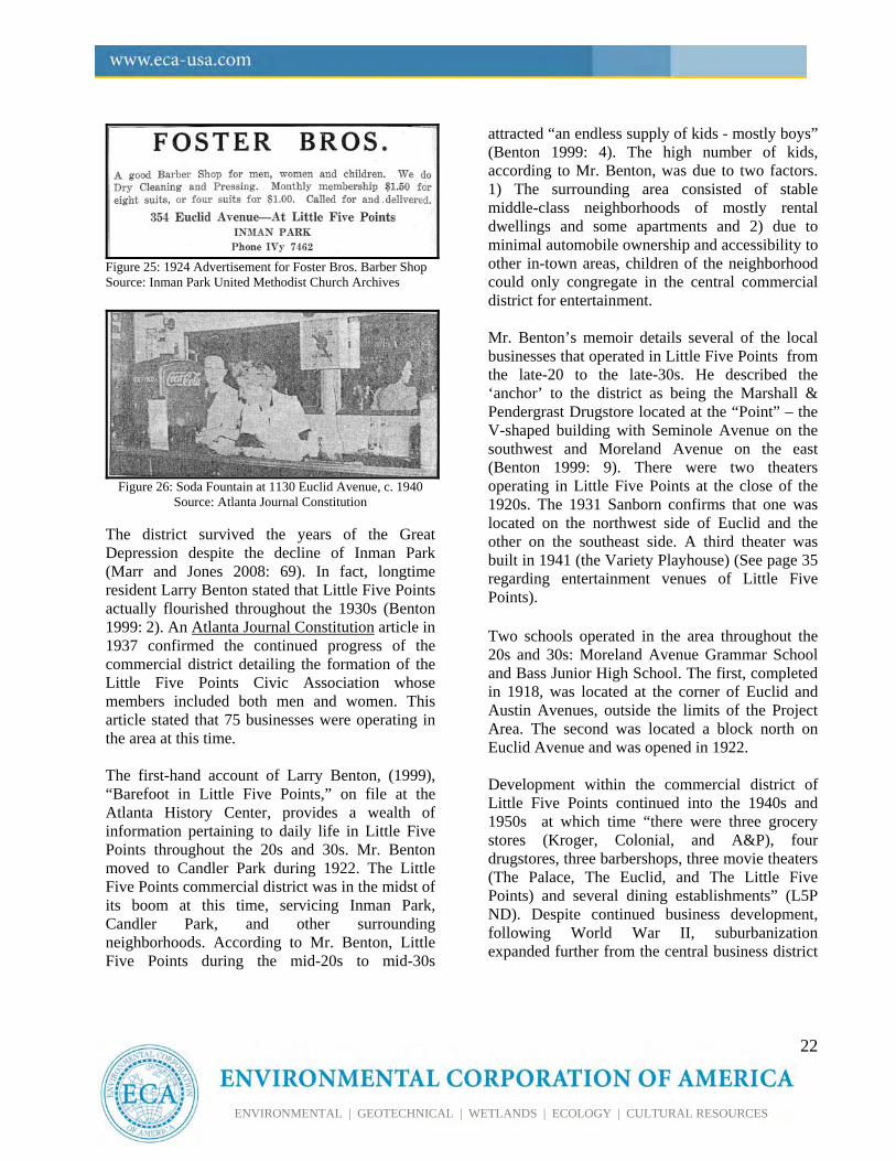
Figure 25: 1924 Advertisement for Foster Bros. Barber Shop Source: Inman Park United Methodist Church Archives
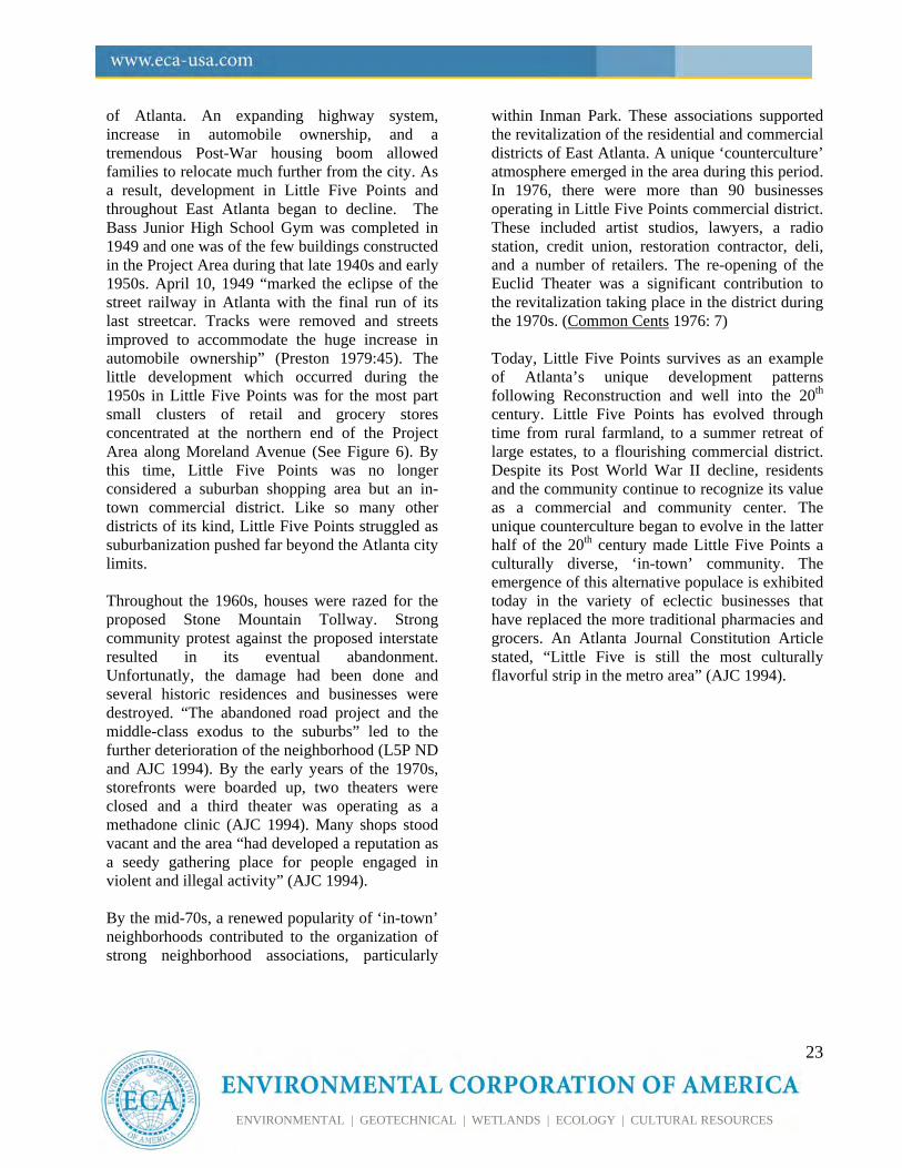
Figure 26: Soda Fountain at 1130 Euclid Avenue, c. 1940
Source: Atlanta Journal Constitution
The district survived the years of the Great Depression despite the decline of Inman Park (Marr and Jones 2008: 69). In fact, longtime resident Larry Benton stated that Little Five Points actually flourished throughout the 1930s (Benton 1999: 2). An Atlanta Journal Constitution article in 1937 confirmed the continued progress of the commercial district detailing the formation of the Little Five Points Civic Association whose members included both men and women. This article stated that 75 businesses were operating in the area at this time. The first-hand account of Larry Benton, (1999), “Barefoot in Little Five Points,” on file at the Atlanta History Center, provides a wealth of information pertaining to daily life in Little Five Points throughout the 20s and 30s. Mr. Benton moved to Candler Park during 1922. The Little Five Points commercial district was in the midst of its boom at this time, servicing Inman Park, Candler Park, and other surrounding neighborhoods. According to Mr. Benton, Little Five Points during the mid-20s to mid-30s
attracted “an endless supply of kids - mostly boys” (Benton 1999: 4). The high number of kids, according to Mr. Benton, was due to two factors. 1) The surrounding area consisted of stable middle-class neighborhoods of mostly rental dwellings and some apartments and 2) due to minimal automobile ownership and accessibility to other in-town areas, children of the neighborhood could only congregate in the central commercial district for entertainment. Mr. Benton’s memoir details several of the local businesses that operated in Little Five Points from the late-20 to the late-30s. He described the ‘anchor’ to the district as being the Marshall & Pendergrast Drugstore located at the “Point” – the V-shaped building with Seminole Avenue on the southwest and Moreland Avenue on the east (Benton 1999: 9). There were two theaters operating in Little Five Points at the close of the 1920s. The 1931 Sanborn confirms that one was located on the northwest side of Euclid and the other on the southeast side. A third theater was built in 1941 (the Variety Playhouse) (See page 35 regarding entertainment venues of Little Five Points). Two schools operated in the area throughout the 20s and 30s: Moreland Avenue Grammar School and Bass Junior High School. The first, completed in 1918, was located at the corner of Euclid and Austin Avenues, outside the limits of the Project Area. The second was located a block north on Euclid Avenue and was opened in 1922. Development within the commercial district of Little Five Points continued into the 1940s and 1950s at which time “there were three grocery stores (Kroger, Colonial, and A&P), four drugstores, three barbershops, three movie theaters (The Palace, The Euclid, and The Little Five Points) and several dining establishments” (L5P ND). Despite continued business development, following World War II, suburbanization expanded further from the central business district
23
ENVIRONMENTAL | GEOTECHNICAL | WETLANDS | ECOLOGY | CULTURAL RESOURCES
of Atlanta. An expanding highway system, increase in automobile ownership, and a tremendous Post-War housing boom allowed families to relocate much further from the city. As a result, development in Little Five Points and throughout East Atlanta began to decline. The Bass Junior High School Gym was completed in 1949 and one was of the few buildings constructed in the Project Area during that late 1940s and early 1950s. April 10, 1949 “marked the eclipse of the street railway in Atlanta with the final run of its last streetcar. Tracks were removed and streets improved to accommodate the huge increase in automobile ownership” (Preston 1979:45). The little development which occurred during the 1950s in Little Five Points was for the most part small clusters of retail and grocery stores concentrated at the northern end of the Project Area along Moreland Avenue (See Figure 6). By this time, Little Five Points was no longer considered a suburban shopping area but an in-town commercial district. Like so many other districts of its kind, Little Five Points struggled as suburbanization pushed far beyond the Atlanta city limits. Throughout the 1960s, houses were razed for the proposed Stone Mountain Tollway. Strong community protest against the proposed interstate resulted in its eventual abandonment. Unfortunatly, the damage had been done and several historic residences and businesses were destroyed. “The abandoned road project and the middle-class exodus to the suburbs” led to the further deterioration of the neighborhood (L5P ND and AJC 1994). By the early years of the 1970s, storefronts were boarded up, two theaters were closed and a third theater was operating as a methadone clinic (AJC 1994). Many shops stood vacant and the area “had developed a reputation as a seedy gathering place for people engaged in violent and illegal activity” (AJC 1994). By the mid-70s, a renewed popularity of ‘in-town’ neighborhoods contributed to the organization of strong neighborhood associations, particularly
within Inman Park. These associations supported the revitalization of the residential and commercial districts of East Atlanta. A unique ‘counterculture’ atmosphere emerged in the area during this period. In 1976, there were more than 90 businesses operating in Little Five Points commercial district. These included artist studios, lawyers, a radio station, credit union, restoration contractor, deli, and a number of retailers. The re-opening of the Euclid Theater was a significant contribution to the revitalization taking place in the district during the 1970s. (Common Cents 1976: 7) Today, Little Five Points survives as an example of Atlanta’s unique development patterns following Reconstruction and well into the 20th century. Little Five Points has evolved through time from rural farmland, to a summer retreat of large estates, to a flourishing commercial district. Despite its Post World War II decline, residents and the community continue to recognize its value as a commercial and community center. The unique counterculture began to evolve in the latter half of the 20th century made Little Five Points a culturally diverse, ‘in-town’ community. The emergence of this alternative populace is exhibited today in the variety of eclectic businesses that have replaced the more traditional pharmacies and grocers. An Atlanta Journal Constitution Article stated, “Little Five is still the most culturally flavorful strip in the metro area” (AJC 1994).
24
ENVIRONMENTAL | GEOTECHNICAL | WETLANDS | ECOLOGY | CULTURAL RESOURCES
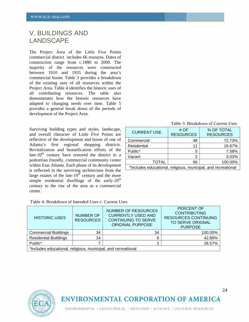
V. BUILDINGS AND LANDSCAPE The Project Area of the Little Five Points commercial district includes 66 resoures. Dates of construction range from c.1880 to 2000. The majority of the resources were constructed between 1910 and 1935 during the area’s commercial boom. Table 3 provides a breakdown of the existing uses of all resources within the Project Area. Table 4 identifies the historic uses of all contributing resources. The table also demonstrates how the historic resources have adapted to changing needs over time. Table 5 provides a general break down of the periods of development of the Project Area. Surviving building types and styles, landscape, and overall character of Little Five Points are reflective of the development and boom of one of Atlanta’s first regional shopping districts. Revitalization and beautification efforts of the late-20th century have restored the district to a pedestrian friendly, commercial community center within East Atlanta. Each phase of its development is reflected in the surviving architecture from the large estates of the late-19th century and the more simple residential dwellings of the early-20th century to the rise of the area as a commercial center.
CURRENT USE # OF
RESOURCES % OF TOTAL RESOURCES
Commercial 48 72.73%Residential 11 16.67%Public* 5 7.58%Vacant 2 3.03%
TOTAL 66 100.00%*Includes educational, religious, municipal, and recreational
HISTORIC USES NUMBER OF RESOURCES
NUMBER OF RESOURCES CURRENTLY USED AND CONTINUING TO SERVE
ORIGINAL PURPOSE
PERCENT OF CONTRIBUTING
RESOURCES CONTINUING TO SERVE ORIGNAL
PURPOSE Commercial Buildings 34 34 100.00%Residential Buildings 14 6 42.86%Public* 7 2 28.57%*Includes educational, religious, municipal, and recreational
Table 4: Breakdown of Intended Uses v. Current Uses
Table 3: Breakdown of Current Uses
25
ENVIRONMENTAL | GEOTECHNICAL | WETLANDS | ECOLOGY | CULTURAL RESOURCES
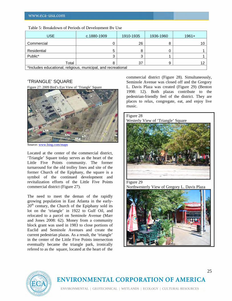
‘TRIANGLE’ SQUARE Figure 27: 2009 Bird’s Eye View of ‘Triangle’ Square
Source: www.bing.com/maps Located at the center of the commercial district, ‘Triangle’ Square today serves as the heart of the Little Five Points community. The former turnaround for the old trolley lines and site of the former Church of the Epiphany, the square is a symbol of the continued development and revitalization efforts of the Little Five Points commercial district (Figure 27). The need to meet the deman of the rapidly growing population in East Atlanta in the early-20th century, the Church of the Epiphany sold its lot on the ‘triangle’ in 1922 to Gulf Oil, and relocated to a parcel on Seminole Avenue (Marr and Jones 2008: 62). Money from a community block grant was used in 1983 to close portions of Euclid and Seminole Avenues and create the current pedestrian plazas. As a result, the ‘triangle’ in the center of the Little Five Points intersection eventually became the triangle park, ironically refered to as the square, located at the heart of the
commercial district (Figure 28). Simultaneously, Seminole Avenue was closed off and the Gregory L. Davis Plaza was created (Figure 29) (Benton 1998: 12). Both plazas contribute to the pedestrian-friendly feel of the district. They are places to relax, congregate, eat, and enjoy live music.
Figure 28 Westerly View of ‘Triangle’ Square
Figure 29 Northwesterly View of Gregory L. Davis Plaza
USE c.1880-1909 1910-1935 1936-1960 1961+
Commercial 0 26 8 10
Residential 5 8 0 1
Public* 3 3 1 1
Total 8 37 9 12*Includes educational, religious, municipal, and recreational
Table 5: Breakdown of Periods of Development By Use
26
ENVIRONMENTAL | GEOTECHNICAL | WETLANDS | ECOLOGY | CULTURAL RESOURCES
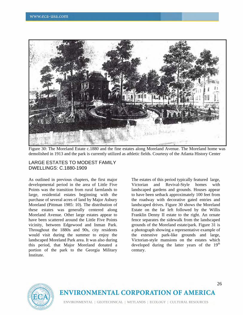
Figure 30: The Moreland Estate c.1880 and the fine estates along Moreland Avenue. The Moreland home was demolished in 1913 and the park is currently utilized as athletic fields. Courtesy of the Atlanta History Center
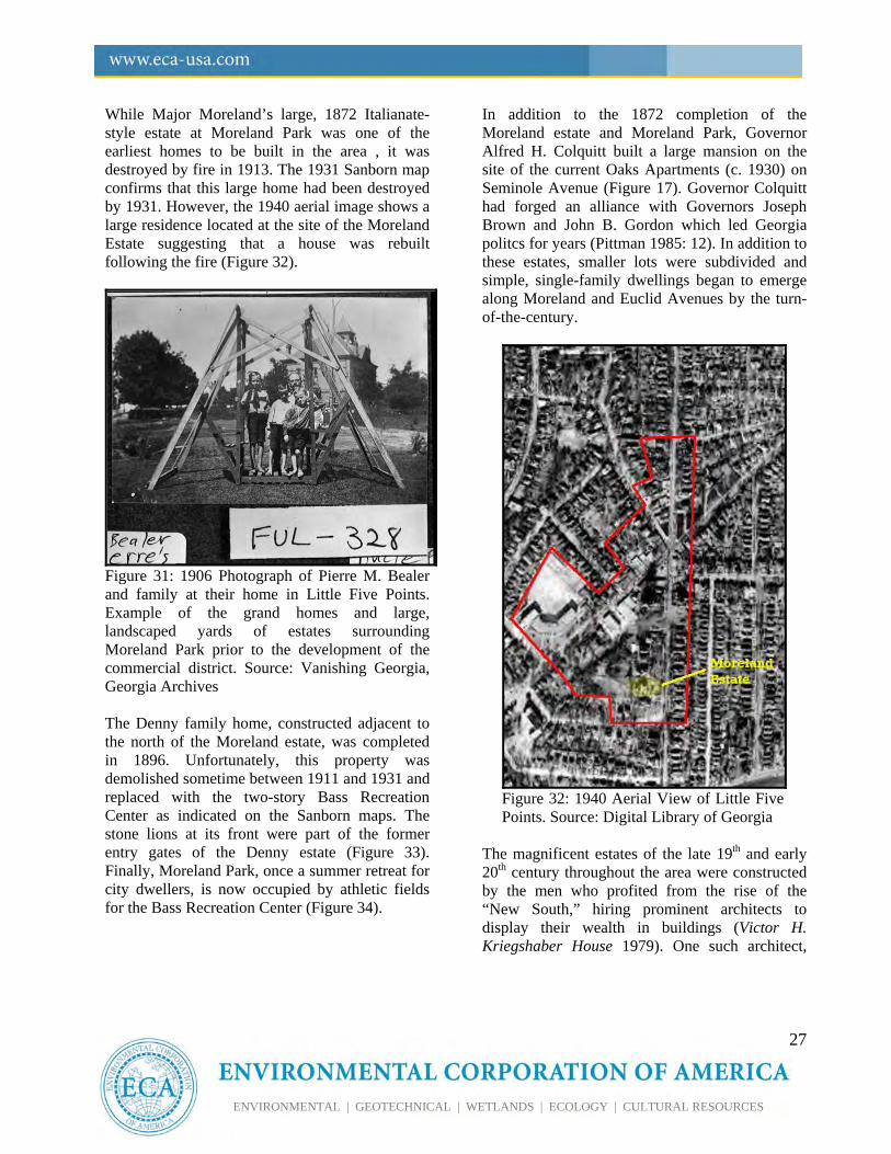
LARGE ESTATES TO MODEST FAMILY DWELLINGS: C.1880-1909 As outlined in previous chapters, the first major developmental period in the area of Little Five Points was the transition from rural farmlands to large, residential estates beginning with the purchase of several acres of land by Major Asbury Moreland (Pittman 1985: 10). The distribution of these estates was generally centered along Moreland Avenue. Other large estates appear to have been scattered around the Little Five Points vicinity, between Edgewood and Inman Park. Throughout the 1880s and 90s, city residents would visit during the summer to enjoy the landscaped Moreland Park area. It was also during this period, that Major Moreland donated a portion of the park to the Georgia Military Institute.
The estates of this period typically featured large, Victorian and Revival-Style homes with landscaped gardens and grounds. Houses appear to have been setback approximately 100 feet from the roadway with decorative gated entries and landscaped drives. Figure 30 shows the Moreland Estate on the far left followed by the Willis Franklin Denny II estate to the right. An ornate fence separates the sidewalk from the landscaped grounds of the Moreland estate/park. Figure 31 is a photograph showing a representative example of the extesnive park-like grounds and large, Victorian-style mansions on the estates which developed during the latter years of the 19th century.
27
ENVIRONMENTAL | GEOTECHNICAL | WETLANDS | ECOLOGY | CULTURAL RESOURCES
While Major Moreland’s large, 1872 Italianate-style estate at Moreland Park was one of the earliest homes to be built in the area , it was destroyed by fire in 1913. The 1931 Sanborn map confirms that this large home had been destroyed by 1931. However, the 1940 aerial image shows a large residence located at the site of the Moreland Estate suggesting that a house was rebuilt following the fire (Figure 32).
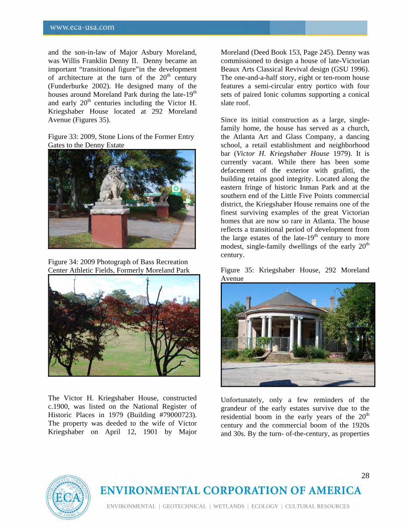
Figure 31: 1906 Photograph of Pierre M. Bealer and family at their home in Little Five Points. Example of the grand homes and large, landscaped yards of estates surrounding Moreland Park prior to the development of the commercial district. Source: Vanishing Georgia, Georgia Archives The Denny family home, constructed adjacent to the north of the Moreland estate, was completed in 1896. Unfortunately, this property was demolished sometime between 1911 and 1931 and replaced with the two-story Bass Recreation Center as indicated on the Sanborn maps. The stone lions at its front were part of the former entry gates of the Denny estate (Figure 33). Finally, Moreland Park, once a summer retreat for city dwellers, is now occupied by athletic fields for the Bass Recreation Center (Figure 34).
In addition to the 1872 completion of the Moreland estate and Moreland Park, Governor Alfred H. Colquitt built a large mansion on the site of the current Oaks Apartments (c. 1930) on Seminole Avenue (Figure 17). Governor Colquitt had forged an alliance with Governors Joseph Brown and John B. Gordon which led Georgia politcs for years (Pittman 1985: 12). In addition to these estates, smaller lots were subdivided and simple, single-family dwellings began to emerge along Moreland and Euclid Avenues by the turn-of-the-century.
Figure 32: 1940 Aerial View of Little Five Points. Source: Digital Library of Georgia
The magnificent estates of the late 19th and early 20th century throughout the area were constructed by the men who profited from the rise of the “New South,” hiring prominent architects to display their wealth in buildings (Victor H. Kriegshaber House 1979). One such architect,
28
ENVIRONMENTAL | GEOTECHNICAL | WETLANDS | ECOLOGY | CULTURAL RESOURCES
and the son-in-law of Major Asbury Moreland, was Willis Franklin Denny II. Denny became an important “transitional figure”in the development of architecture at the turn of the 20th century (Funderburke 2002). He designed many of the houses around Moreland Park during the late-19th and early 20th centuries including the Victor H. Kriegshaber House located at 292 Moreland Avenue (Figures 35). Figure 33: 2009, Stone Lions of the Former Entry Gates to the Denny Estate
Figure 34: 2009 Photograph of Bass Recreation Center Athletic Fields, Formerly Moreland Park
The Victor H. Kriegshaber House, constructed c.1900, was listed on the National Register of Historic Places in 1979 (Building #79000723). The property was deeded to the wife of Victor Kriegshaber on April 12, 1901 by Major
Moreland (Deed Book 153, Page 245). Denny was commissioned to design a house of late-Victorian Beaux Arts Classical Revival design (GSU 1996). The one-and-a-half story, eight or ten-room house features a semi-circular entry portico with four sets of paired Ionic columns supporting a conical slate roof. Since its initial construction as a large, single-family home, the house has served as a church, the Atlanta Art and Glass Company, a dancing school, a retail establishment and neighborhood bar (Victor H. Kriegshaber House 1979). It is currently vacant. While there has been some defacement of the exterior with grafitti, the building retains good integrity. Located along the eastern fringe of historic Inman Park and at the southern end of the Little Five Points commercial district, the Kriegshaber House remains one of the finest surviving examples of the great Victorian homes that are now so rare in Atlanta. The house reflects a transitional period of development from the large estates of the late-19th century to more modest, single-family dwellings of the early 20th century. Figure 35: Kriegshaber House, 292 Moreland Avenue
Unfortunately, only a few reminders of the grandeur of the early estates survive due to the residential boom in the early years of the 20th century and the commercial boom of the 1920s and 30s. By the turn- of-the-century, as properties
29
ENVIRONMENTAL | GEOTECHNICAL | WETLANDS | ECOLOGY | CULTURAL RESOURCES
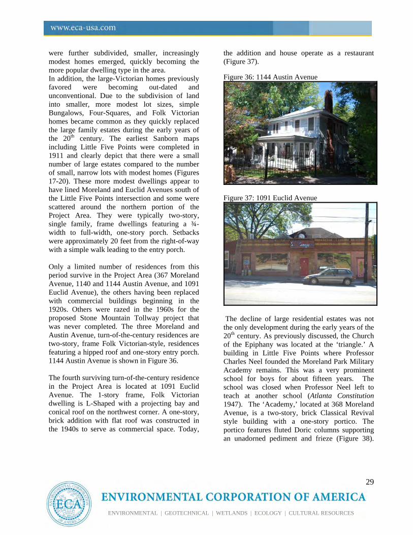
were further subdivided, smaller, increasingly modest homes emerged, quickly becoming the more popular dwelling type in the area. In addition, the large-Victorian homes previously favored were becoming out-dated and unconventional. Due to the subdivision of land into smaller, more modest lot sizes, simple Bungalows, Four-Squares, and Folk Victorian homes became common as they quickly replaced the large family estates during the early years of the 20th century. The earliest Sanborn maps including Little Five Points were completed in 1911 and clearly depict that there were a small number of large estates compared to the number of small, narrow lots with modest homes (Figures 17-20). These more modest dwellings appear to have lined Moreland and Euclid Avenues south of the Little Five Points intersection and some were scattered around the northern portion of the Project Area. They were typically two-story, single family, frame dwellings featuring a ¾-width to full-width, one-story porch. Setbacks were approximately 20 feet from the right-of-way with a simple walk leading to the entry porch. Only a limited number of residences from this period survive in the Project Area (367 Moreland Avenue, 1140 and 1144 Austin Avenue, and 1091 Euclid Avenue), the others having been replaced with commercial buildings beginning in the 1920s. Others were razed in the 1960s for the proposed Stone Mountain Tollway project that was never completed. The three Moreland and Austin Avenue, turn-of-the-century residences are two-story, frame Folk Victorian-style, residences featuring a hipped roof and one-story entry porch. 1144 Austin Avenue is shown in Figure 36. The fourth surviving turn-of-the-century residence in the Project Area is located at 1091 Euclid Avenue. The 1-story frame, Folk Victorian dwelling is L-Shaped with a projecting bay and conical roof on the northwest corner. A one-story, brick addition with flat roof was constructed in the 1940s to serve as commercial space. Today,
the addition and house operate as a restaurant (Figure 37). Figure 36: 1144 Austin Avenue
Figure 37: 1091 Euclid Avenue
The decline of large residential estates was not the only development during the early years of the 20th century. As previously discussed, the Church of the Epiphany was located at the ‘triangle.’ A building in Little Five Points where Professor Charles Neel founded the Moreland Park Military Academy remains. This was a very prominent school for boys for about fifteen years. The school was closed when Professor Neel left to teach at another school (Atlanta Constitution 1947). The ‘Academy,’ located at 368 Moreland Avenue, is a two-story, brick Classical Revival style building with a one-story portico. The portico features fluted Doric columns supporting an unadorned pediment and frieze (Figure 38).
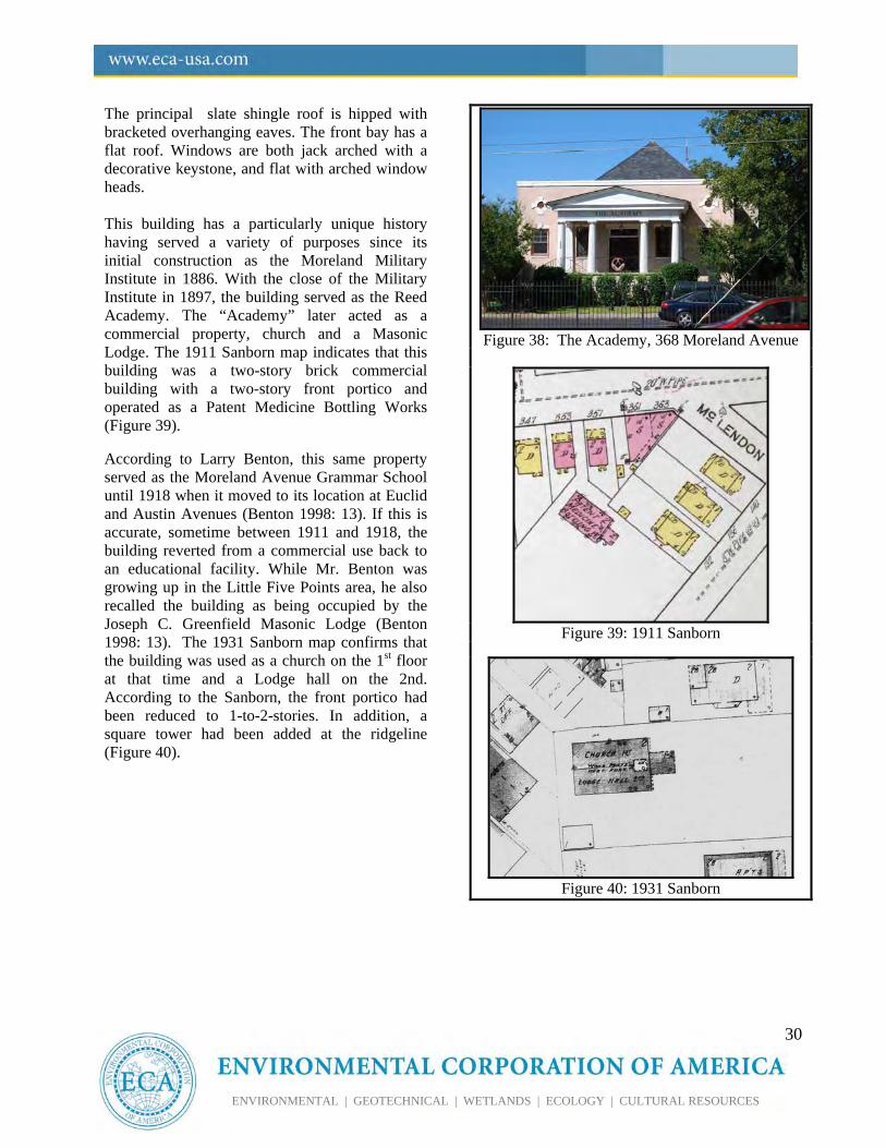
30
ENVIRONMENTAL | GEOTECHNICAL | WETLANDS | ECOLOGY | CULTURAL RESOURCES
The principal slate shingle roof is hipped with bracketed overhanging eaves. The front bay has a flat roof. Windows are both jack arched with a decorative keystone, and flat with arched window heads. This building has a particularly unique history having served a variety of purposes since its initial construction as the Moreland Military Institute in 1886. With the close of the Military Institute in 1897, the building served as the Reed Academy. The “Academy” later acted as a commercial property, church and a Masonic Lodge. The 1911 Sanborn map indicates that this building was a two-story brick commercial building with a two-story front portico and operated as a Patent Medicine Bottling Works (Figure 39).
According to Larry Benton, this same property served as the Moreland Avenue Grammar School until 1918 when it moved to its location at Euclid and Austin Avenues (Benton 1998: 13). If this is accurate, sometime between 1911 and 1918, the building reverted from a commercial use back to an educational facility. While Mr. Benton was growing up in the Little Five Points area, he also recalled the building as being occupied by the Joseph C. Greenfield Masonic Lodge (Benton 1998: 13). The 1931 Sanborn map confirms that the building was used as a church on the 1st floor at that time and a Lodge hall on the 2nd. According to the Sanborn, the front portico had been reduced to 1-to-2-stories. In addition, a square tower had been added at the ridgeline (Figure 40).
Figure 38: The Academy, 368 Moreland Avenue
Figure 39: 1911 Sanborn
Figure 40: 1931 Sanborn
31
ENVIRONMENTAL | GEOTECHNICAL | WETLANDS | ECOLOGY | CULTURAL RESOURCES
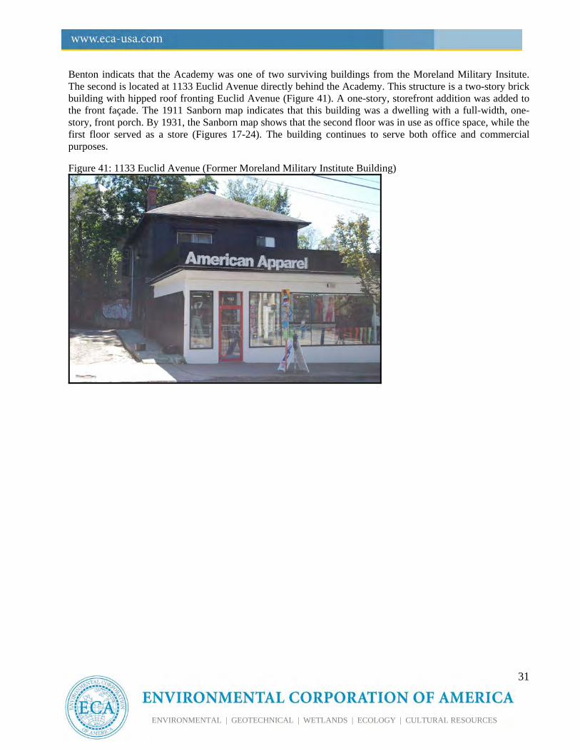
Benton indicats that the Academy was one of two surviving buildings from the Moreland Military Insitute. The second is located at 1133 Euclid Avenue directly behind the Academy. This structure is a two-story brick building with hipped roof fronting Euclid Avenue (Figure 41). A one-story, storefront addition was added to the front façade. The 1911 Sanborn map indicates that this building was a dwelling with a full-width, one-story, front porch. By 1931, the Sanborn map shows that the second floor was in use as office space, while the first floor served as a store (Figures 17-24). The building continues to serve both office and commercial purposes. Figure 41: 1133 Euclid Avenue (Former Moreland Military Institute Building)
32
ENVIRONMENTAL | GEOTECHNICAL | WETLANDS | ECOLOGY | CULTURAL RESOURCES
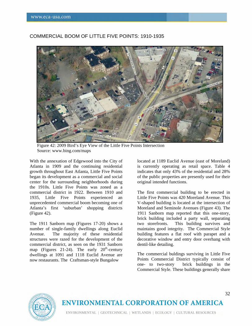
COMMERCIAL BOOM OF LITTLE FIVE POINTS: 1910-1935
Figure 42: 2009 Bird’s Eye View of the Little Five Points Intersection Source: www.bing.com/maps
With the annexation of Edgewood into the City of Atlanta in 1909 and the continuing residential growth throughout East Atlanta, Little Five Points began its development as a commercial and social center for the surrounding neighborhoods during the 1910s. Little Five Points was zoned as a commercial district in 1922. Between 1910 and 1935, Little Five Points experienced an unprecedented commercial boom becoming one of Atlanta’s first ‘suburban’ shopping districts (Figure 42). The 1911 Sanborn map (Figures 17-20) shows a number of single-family dwellings along Euclid Avenue. The majority of these residential structures were razed for the development of the commercial district, as seen on the 1931 Sanborn map (Figures 21-24). The early 20th-century dwellings at 1091 and 1118 Euclid Avenue are now restaurants. The Craftsman-style Bungalow
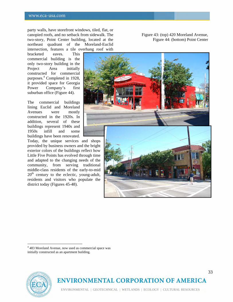
located at 1189 Euclid Avenue (east of Moreland) is currently operating as retail space. Table 4 indicates that only 43% of the residential and 28% of the public properties are presently used for their original intended functions. The first commercial building to be erected in Little Five Points was 420 Moreland Avenue. This V-shaped building is located at the intersection of Moreland and Seminole Avenues (Figure 43). The 1911 Sanborn map reported that this one-story, brick building included a party wall, separating two storefronts. This building survives and maintains good integrity. The Commercial Style building features a flat roof with parapet and a decorative window and entry door overhang with dentil-like detailing. The commercial buldings surviving in Little Five Points Commercial District typically consist of one- to two-story brick buildings in the Commercial Style. These buildings generally share
33
ENVIRONMENTAL | GEOTECHNICAL | WETLANDS | ECOLOGY | CULTURAL RESOURCES
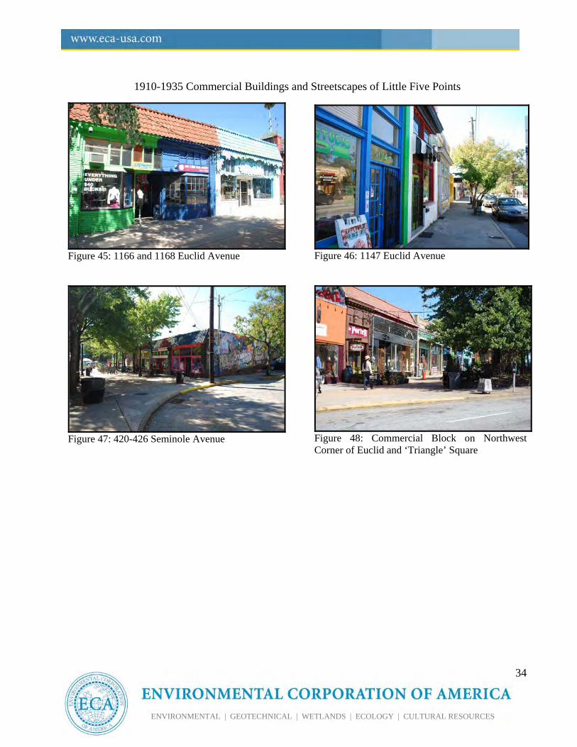
party walls, have storefront windows, tiled, flat, or canopied roofs, and no setback from sidewalk. The two-story, Point Center building, located at the northeast quadrant of the Moreland-Euclid intersection, features a tile overhang roof with bracketed eaves. This commercial building is the only two-story building in the Project Area initially constructed for commercial purposes.4 Completed in 1928, it provided space for Georgia Power Company’s first suburban office (Figure 44). The commercial buildings lining Euclid and Moreland Avenues were mostly constructed in the 1920s. In addition, several of these buildings represent 1940s and 1950s infill and some buildings have been renovated. Today, the unique services and shops provided by business owners and the bright exterior colors of the buildings reflect how Little Five Points has evolved through time and adapted to the changing needs of the community, from serving traditional middle-class residents of the early-to-mid 20th century to the eclectic, young-adult, residents and visitors who populate the district today (Figures 45-48).
4 483 Moreland Avenue, now used as commercial space was initially constructed as an apartment building.
Figure 43: (top) 420 Moreland Avenue, Figure 44: (bottom) Point Center
34
ENVIRONMENTAL | GEOTECHNICAL | WETLANDS | ECOLOGY | CULTURAL RESOURCES
1910-1935 Commercial Buildings and Streetscapes of Little Five Points
Figure 45: 1166 and 1168 Euclid Avenue
Figure 47: 420-426 Seminole Avenue
Figure 46: 1147 Euclid Avenue
Figure 48: Commercial Block on Northwest Corner of Euclid and ‘Triangle’ Square
35
ENVIRONMENTAL | GEOTECHNICAL | WETLANDS | ECOLOGY | CULTURAL RESOURCES
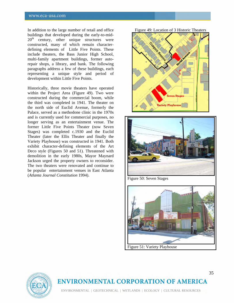
In addition to the large number of retail and office buildings that developed during the early-to-mid-20th century, other unique structures were constructed, many of which remain character-defining elements of Little Five Points. These include theaters, the Bass Junior High School, multi-family apartment buildings, former auto-repair shops, a library, and bank. The following paragraphs address a few of these buildings, each representing a unique style and period of development within Little Five Points. Historically, three movie theaters have operated within the Project Area (Figure 49). Two were constructed during the commercial boom, while the third was completed in 1941. The theater on the north side of Euclid Avenue, formerly the Palace, served as a methodone clinic in the 1970s and is currently used for commercial purposes, no longer serving as an entertainment venue. The former Little Five Points Theater (now Seven Stages) was completed c.1930 and the Euclid Theater (later the Ellis Theater and finally the Variety Playhouse) was constructed in 1941. Both exhibit character-defining elements of the Art Deco style (Figures 50 and 51). Threatened with demolition in the early 1980s, Mayor Maynard Jackson urged the property owners to reconsider. The two theaters were renovated and continue to be popular entertainment venues in East Atlanta (Atlanta Journal Constitution 1994).
Figure 49: Location of 3 Historic Theaters
Figure 50: Seven Stages
Figure 51: Variety Playhouse
36
ENVIRONMENTAL | GEOTECHNICAL | WETLANDS | ECOLOGY | CULTURAL RESOURCES
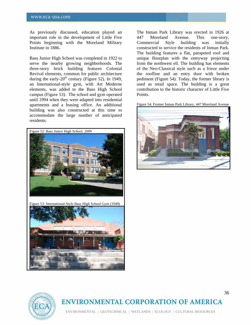
As previously discussed, education played an important role in the development of Little Five Points beginning with the Moreland Military Institute in 1886. Bass Junior High School was completed in 1922 to serve the nearby growing neighborhoods. The three-story brick building features Colonial Revival elements, common for public architecture during the early-20th century (Figure 52). In 1949, an International-style gym, with Art Moderne elements, was added to the Bass High School campus (Figure 53). The school and gym operated until 1994 when they were adapted into residential apartments and a leasing office. An additional building was also constructed at this time to accommodate the large number of anticipated residents. Figure 52: Bass Junior High School, 2009
Figure 53: International-Style Bass High School Gym (1949)
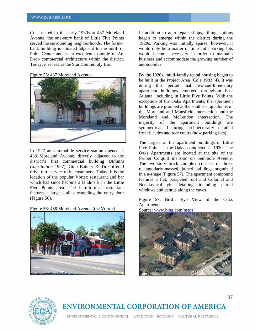
The Inman Park Library was erected in 1926 at 447 Moreland Avenue. This one-story, Commercial Style building was initially constructed to service the residents of Inman Park. The building features a flat, parapeted roof and unique floorplan with the entryway projecting from the northwest ell. The building has elements of the Neo-Classical style such as a frieze under the roofline and an entry door with broken pediment (Figure 54). Today, the former library is used as retail space. The building is a great contribution to the historic character of Little Five Points. Figure 54: Former Inman Park Library, 447 Moreland Avenue
37
ENVIRONMENTAL | GEOTECHNICAL | WETLANDS | ECOLOGY | CULTURAL RESOURCES
Constructed in the early 1930s at 437 Moreland Avenue, the one-story bank of Little Five Points served the surrounding neighborhoods. The former bank building is situated adjacent to the north of Point Center and is an excellent example of Art Deco commercial architecture within the district. Today, it serves as the Star Community Bar. Figure 55: 437 Moreland Avenue
In 1927 an automobile service station opened at 438 Moreland Avenue, directly adjacent to the district’s first commercial building (Atlanta Constitution 1927). Ginn Battery & Tire offered drive-thru service to its customers. Today, it is the location of the popular Vortex restaurant and bar which has since become a landmark in the Little Five Points area. The hard-to-miss restaurant features a large skull surrounding the entry door (Figure 56). Figure 56: 438 Moreland Avenue (the Vortex)
In addition to auto repair shops, filling stations began to emerge within the district during the 1920s. Parking was initially sparse; however, it would only be a matter of time until parking lots would become necessary in order to maintain business and accommodate the growing number of automobiles. By the 1920s, multi-family rental housing began to be built in the Project Area (Cole 1983: 4). It was during this period that two-and-three-story apartment buildings emerged throughout East Atlanta, including in Little Five Points. With the exception of the Oaks Apartments, the apartment buildings are grouped at the southeast quadrants of the Moreland and Mansfield intersection and the Moreland and McLendon intersection. The majority of the apartment buildings are symmetrical, featuring architecturally detailed front facades and rear courts (now parking lots). The largest of the apartment buildings in Little Five Points is the Oaks, completed c. 1930. The Oaks Apartments are located at the site of the former Colquitt mansion on Seminole Avenue. The two-story brick complex consists of three, rectangularly-massed, joined buildings organized in a u-shape (Figure 57). The apartment compound features a flat, parapeted roof and Colonial and Neoclassical-style detailing including paired windows and dentils along the eaves. Figure 57: Bird’s Eye View of the Oaks Apartments Source: www.bing.com/maps
38
ENVIRONMENTAL | GEOTECHNICAL | WETLANDS | ECOLOGY | CULTURAL RESOURCES
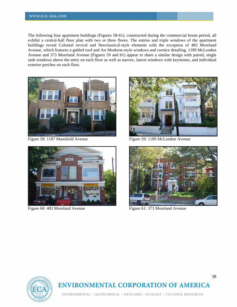
The following four apartment buildings (Figures 58-61), constructed during the commercial boom period, all exhibit a central-hall floor plan with two or three floors. The entries and triple windows of the apartment buildings reveal Colonial revival and Neoclassical-style elements with the exception of 483 Moreland Avenue, which features a gabled roof and Art Moderne-style windows and cornice detailing. 1189 McLendon Avenue and 373 Moreland Avenue (Figures 59 and 61) appear to share a similar design with paired, single sash windows above the entry on each floor as well as narrow, lancet windows with keystones, and individual exterior porches on each floor.
Figure 58: 1187 Mansfield Avenue
Figure 60: 483 Moreland Avenue
Figure 59: 1189 McLendon Avenue
Figure 61: 373 Moreland Avenue
39
ENVIRONMENTAL | GEOTECHNICAL | WETLANDS | ECOLOGY | CULTURAL RESOURCES
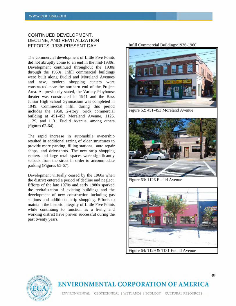
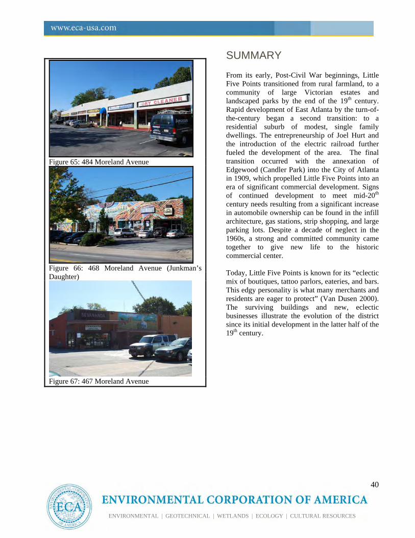
CONTINUED DEVELOPMENT, DECLINE, AND REVITALIZATION EFFORTS: 1936-PRESENT DAY The commercial development of Little Five Points did not abruptly come to an end in the mid-1930s. Development continued throughout the 1930s through the 1950s. Infill commercial buildings were built along Euclid and Moreland Avenues and new, modern shopping centers were constructed near the northern end of the Project Area. As previously stated, the Variety Playhouse theater was constructed in 1941 and the Bass Junior High School Gymnasium was completed in 1949. Commercial infill during this period includes the 1950, 2-story, brick commercial building at 451-453 Moreland Avenue, 1126, 1129, and 1131 Euclid Avenue, among others (figures 62-64). The rapid increase in automobile ownership resulted in additional razing of older structures to provide more parking, filling stations, auto repair shops, and drive-thrus. The new strip shopping centers and large retail spaces were significantly setback from the street in order to accommodate parking (Figures 65-67). Development virtually ceased by the 1960s when the district entered a period of decline and neglect. Efforts of the late 1970s and early 1980s sparked the revitalization of existing buildings and the development of new construction including gas stations and additional strip shopping. Efforts to maintain the historic integrity of Little Five Points while continuing to function as a living and working district have proven successful during the past twenty years.
Infill Commercial Buildings:1936-1960
Figure 62: 451-453 Moreland Avenue
Figure 63: 1126 Euclid Avenue
Figure 64: 1129 & 1131 Euclid Avenue
40
ENVIRONMENTAL | GEOTECHNICAL | WETLANDS | ECOLOGY | CULTURAL RESOURCES
Figure 65: 484 Moreland Avenue
Figure 66: 468 Moreland Avenue (Junkman’s Daughter)
Figure 67: 467 Moreland Avenue
SUMMARY From its early, Post-Civil War beginnings, Little Five Points transitioned from rural farmland, to a community of large Victorian estates and landscaped parks by the end of the 19th century. Rapid development of East Atlanta by the turn-of-the-century began a second transition: to a residential suburb of modest, single family dwellings. The entrepreneurship of Joel Hurt and the introduction of the electric railroad further fueled the development of the area. The final transition occurred with the annexation of Edgewood (Candler Park) into the City of Atlanta in 1909, which propelled Little Five Points into an era of significant commercial development. Signs of continued development to meet mid-20th century needs resulting from a significant increase in automobile ownership can be found in the infill architecture, gas stations, strip shopping, and large parking lots. Despite a decade of neglect in the 1960s, a strong and committed community came together to give new life to the historic commercial center. Today, Little Five Points is known for its “eclectic mix of boutiques, tattoo parlors, eateries, and bars. This edgy personality is what many merchants and residents are eager to protect” (Van Dusen 2000). The surviving buildings and new, eclectic businesses illustrate the evolution of the district since its initial development in the latter half of the 19th century.
46
ENVIRONMENTAL | GEOTECHNICAL | WETLANDS | ECOLOGY | CULTURAL RESOURCES
V. REFERENCES CITED Anderson, Holly and Ced Dolder
2003 Inman Park – Moreland Historic District Nomination Form. Georgia Department of Natural Resources Historic Preservation Division and Ray & Associates.
Atlanta Constitution
May 29, 1927 “Little Five Points Now Lively Business Center.” Page 8. May 29, 1927. Retrieved from Proquest Historical Newspapers Atlanta Consititution.
Atlanta Constitution
1937 “Little Five Points Civic Association Organized to Upbuild Community,” Page 3, November 23, 1937. Retrieved from Proquest Historical Newspapers Atlanta Consititution.
Atlanta Constitution 1947 (untitled) August 31, 1947. On file at Atlanta Public Library reference on Inman Park.
Atlanta Journal Constitution
1994 “The Evolving Little Five Points”. Atlanta Journal Constitution, May 22, 1994. On file in the
Neighborhood files at the Atlanta History Center. Benton, Larry
1999 Barefoot in Little Five Points. First-hand account of life in L5P in the early-20th century. On file in the neighborhood vertical file at the Atlanta History Center.
Cram, George F.
1883 Indexed Railroad and County Map of Georgia. Chicago.
Cole, Hal 1983 Moreland District Draft National Register Nomination. Transportation
Planner Associate. Fulton County Deed Books Various On file Fulton County Courthouse, Atlanta.
47
ENVIRONMENTAL | GEOTECHNICAL | WETLANDS | ECOLOGY | CULTURAL RESOURCES
Funderburke, Richard D. 2002 W.F. Denny 1874-1905. Electronic Document from the New Georgia
Encyclopedia. Georgia Humanities Council and the University of Georgia Press. http://www.georgiaencyclopedia.org/nge/Article.jsp?id=h-715. Retrieved October 2009.
Galloway, Tammy H.
2007 “Joel Hurt 1850-1926.” Electronic Document from the New Georgia Encyclopedia. Georgia Humanities Council and the University of Georgia Press. http://www.georgiaencyclopedia.org/nge/Article.jsp?id=h-2910&hl=y. Retrieved October 2009.
Garrett, Franklin M.
Atlanta and Environs: A Chronicle of Its People and Events. University of Georgia Press, Athens, Georgia. (Originally Published by Lewis Historical Publishing Co, 1954).
Georgia Aerial Photographs
1940, 1960, 1972, 1993 Digital Library of Georgia. http://dbs.galib.uga.edu/gaph/html/
Georgia State University, MS Graduate Students (GSU)
1996 The Evolution of 292 Moreland Avenue. Submitted as part of a historic structure report accomplished by students of the Georgia State University Masters of Heritage Preservation. On file at State Historic Preservation Office.
Inman Park Neighborhood Association (IPNA)
ND A Short History of Inman Park. http://www. inmanpark.org, accessed October 2009.
Jordan
1977 “Some Ancient History of Little Five Points.” The Community Star. Vol.VII, No.5. P.11. Available in the neighborhood vertical file at the Atlanta History Center.
Kuhn, Clifford M., Harlon E. Joye, and E. Bernard West
1990 Living Atlanta: An Oral History of the City, 1914-1948. University of Georgia Press, Atlanta, GA
Lankevich, George J.
1978 Atlanta: A Chronological and Documentary History. Oceana Publications, Inc. Dobbs Ferry, New York
48
ENVIRONMENTAL | GEOTECHNICAL | WETLANDS | ECOLOGY | CULTURAL RESOURCES
Little Five Points Business Association (L5P)
ND “Little Five Points.” Retrieved from www.inmanpark.org/l5p.html, September 2009.
Marr, Christine V. and Sharon Foster Jones
2008 Images of America: Inman Park. Arcadia Publishing, Charleston, South Carolina.
National Park Service (NPS)
ND Travel Itinerary: Inman Park-Moreland Historic District. http://www.nps.gov/history/nr/travel/atlanta/ihd.htm, accessed October 2009.
Pittman, Maurine
1985 Inman Park Historic District – Eastern Extension Draft National Register Nomination Form. Inman Park Restoration, Inc.
Preston, Howard L.
1979 Automobile Age Atlanta: The Making of a Southern Metropolis, 1900-1935. University of Georgia Press, Athens, GA.
Sanborn Fire Insurance Maps. 1911, 1931 On file at the Atlanta History Center. Van Dusen, Christine
2000 “Is Little Five Points Becoming Main Street?” Atlanta Journal Constitution. , December 24, 2000.
Victor H. Kriegshaber House
1980 Nomination Form. National Register of Historic Places. United States Department of the Interior, National Park Service.
49
ENVIRONMENTAL | GEOTECHNICAL | WETLANDS | ECOLOGY | CULTURAL RESOURCES
ATTACHMENTS
Attachment 1: Little Five Points Inventory List Attachment 2: Photograph Log of Select Resources and Streetscapes
50
ENVIRONMENTAL | GEOTECHNICAL | WETLANDS | ECOLOGY | CULTURAL RESOURCES
Attachment 1: Little Five Points Inventory
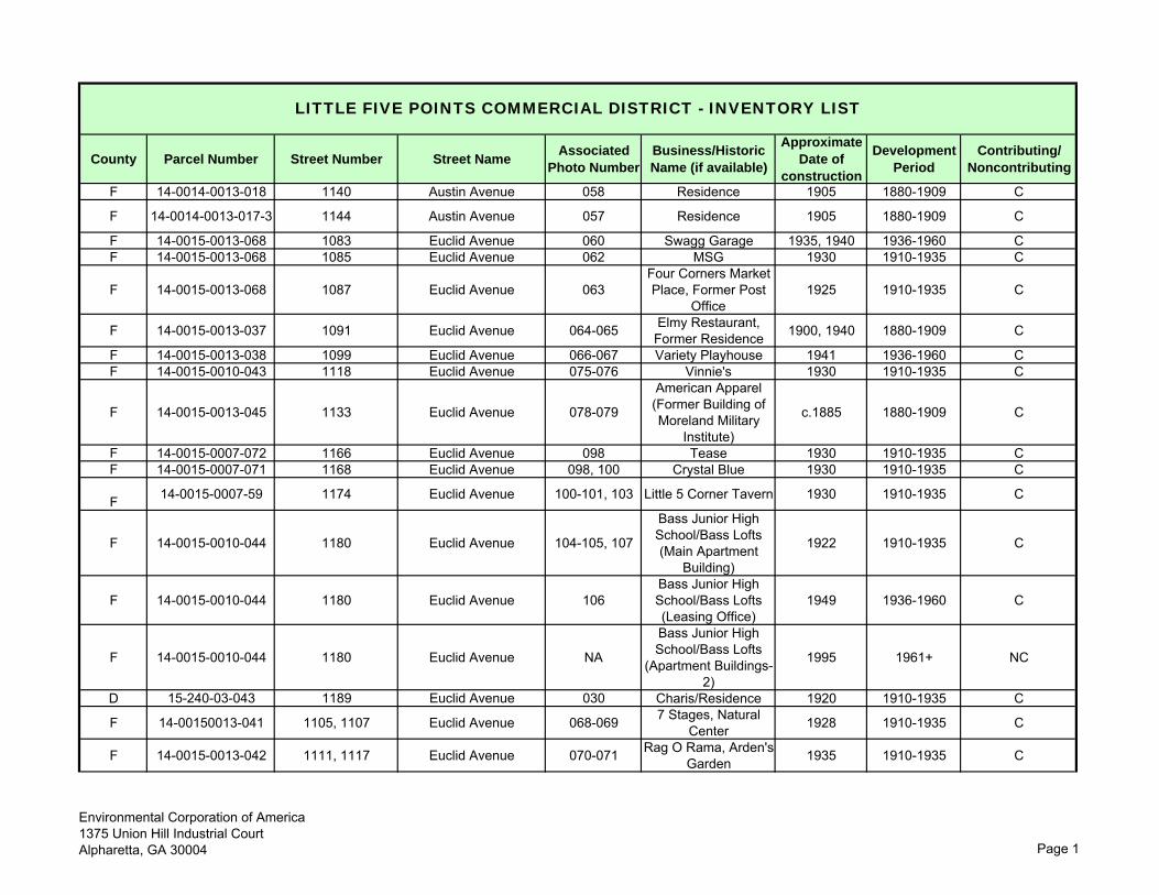
County Parcel Number Street Number Street NameAssociated
Photo NumberBusiness/Historic Name (if available)
Approximate Date of
construction
Development Period
Contributing/ Noncontributing
F 14-0014-0013-018 1140 Austin Avenue 058 Residence 1905 1880-1909 C
F 14-0014-0013-017-3 1144 Austin Avenue 057 Residence 1905 1880-1909 C
F 14-0015-0013-068 1083 Euclid Avenue 060 Swagg Garage 1935, 1940 1936-1960 CF 14-0015-0013-068 1085 Euclid Avenue 062 MSG 1930 1910-1935 C
F 14-0015-0013-068 1087 Euclid Avenue 063Four Corners Market Place, Former Post
Office1925 1910-1935 C
F 14-0015-0013-037 1091 Euclid Avenue 064-065 Elmy Restaurant, Former Residence 1900, 1940 1880-1909 C
F 14-0015-0013-038 1099 Euclid Avenue 066-067 Variety Playhouse 1941 1936-1960 CF 14-0015-0010-043 1118 Euclid Avenue 075-076 Vinnie's 1930 1910-1935 C
F 14-0015-0013-045 1133 Euclid Avenue 078-079
American Apparel (Former Building of Moreland Military
Institute)
c.1885 1880-1909 C
F 14-0015-0007-072 1166 Euclid Avenue 098 Tease 1930 1910-1935 CF 14-0015-0007-071 1168 Euclid Avenue 098, 100 Crystal Blue 1930 1910-1935 C
F 14-0015-0007-59 1174 Euclid Avenue 100-101, 103 Little 5 Corner Tavern 1930 1910-1935 C
F 14-0015-0010-044 1180 Euclid Avenue 104-105, 107
Bass Junior High School/Bass Lofts (Main Apartment
Building)
1922 1910-1935 C
F 14-0015-0010-044 1180 Euclid Avenue 106Bass Junior High School/Bass Lofts (Leasing Office)
1949 1936-1960 C
F 14-0015-0010-044 1180 Euclid Avenue NA
Bass Junior High School/Bass Lofts
(Apartment Buildings-2)
1995 1961+ NC
D 15-240-03-043 1189 Euclid Avenue 030 Charis/Residence 1920 1910-1935 C
F 14-00150013-041 1105, 1107 Euclid Avenue 068-069 7 Stages, Natural Center 1928 1910-1935 C
F 14-0015-0013-042 1111, 1117 Euclid Avenue 070-071 Rag O Rama, Arden's Garden 1935 1910-1935 C
LITTLE FIVE POINTS COMMERCIAL DISTRICT - INVENTORY LIST
Environmental Corporation of America1375 Union Hill Industrial CourtAlpharetta, GA 30004 Page 1
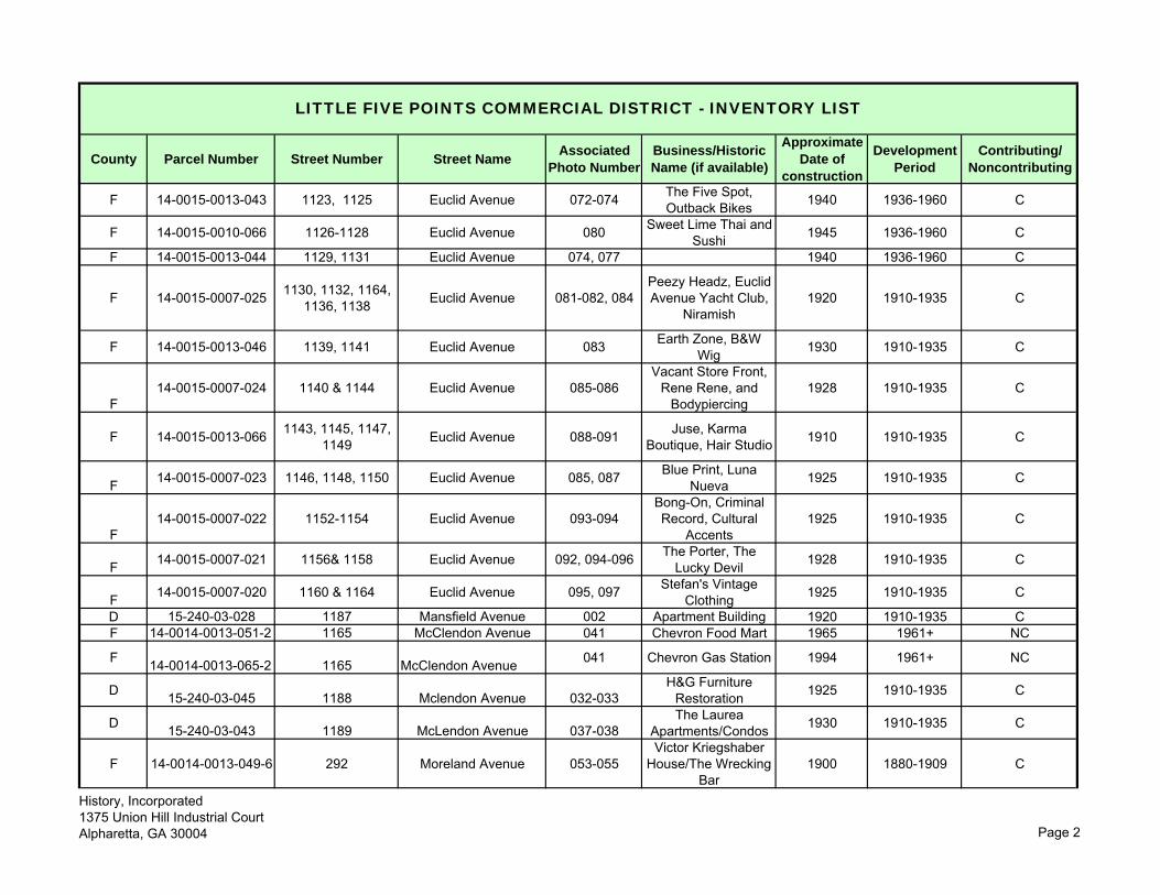
County Parcel Number Street Number Street NameAssociated
Photo NumberBusiness/Historic Name (if available)
Approximate Date of
construction
Development Period
Contributing/ Noncontributing
LITTLE FIVE POINTS COMMERCIAL DISTRICT - INVENTORY LIST
F 14-0015-0013-043 1123, 1125 Euclid Avenue 072-074 The Five Spot, Outback Bikes 1940 1936-1960 C
F 14-0015-0010-066 1126-1128 Euclid Avenue 080 Sweet Lime Thai and Sushi 1945 1936-1960 C
F 14-0015-0013-044 1129, 1131 Euclid Avenue 074, 077 1940 1936-1960 C
F 14-0015-0007-025 1130, 1132, 1164, 1136, 1138 Euclid Avenue 081-082, 084
Peezy Headz, Euclid Avenue Yacht Club,
Niramish1920 1910-1935 C
F 14-0015-0013-046 1139, 1141 Euclid Avenue 083 Earth Zone, B&W Wig 1930 1910-1935 C
F14-0015-0007-024 1140 & 1144 Euclid Avenue 085-086
Vacant Store Front, Rene Rene, and
Bodypiercing1928 1910-1935 C
F 14-0015-0013-066 1143, 1145, 1147, 1149 Euclid Avenue 088-091 Juse, Karma
Boutique, Hair Studio 1910 1910-1935 C
F 14-0015-0007-023 1146, 1148, 1150 Euclid Avenue 085, 087 Blue Print, Luna Nueva 1925 1910-1935 C
F14-0015-0007-022 1152-1154 Euclid Avenue 093-094
Bong-On, Criminal Record, Cultural
Accents1925 1910-1935 C
F 14-0015-0007-021 1156& 1158 Euclid Avenue 092, 094-096 The Porter, The Lucky Devil 1928 1910-1935 C
F 14-0015-0007-020 1160 & 1164 Euclid Avenue 095, 097 Stefan's Vintage Clothing 1925 1910-1935 C
D 15-240-03-028 1187 Mansfield Avenue 002 Apartment Building 1920 1910-1935 CF 14-0014-0013-051-2 1165 McClendon Avenue 041 Chevron Food Mart 1965 1961+ NC
F 14-0014-0013-065-2 1165 McClendon Avenue 041 Chevron Gas Station 1994 1961+ NC
D 15-240-03-045 1188 Mclendon Avenue 032-033H&G Furniture
Restoration 1925 1910-1935 C
D 15-240-03-043 1189 McLendon Avenue 037-038The Laurea
Apartments/Condos 1930 1910-1935 C
F 14-0014-0013-049-6 292 Moreland Avenue 053-055Victor Kriegshaber
House/The Wrecking Bar
1900 1880-1909 C
History, Incorporated1375 Union Hill Industrial CourtAlpharetta, GA 30004 Page 2
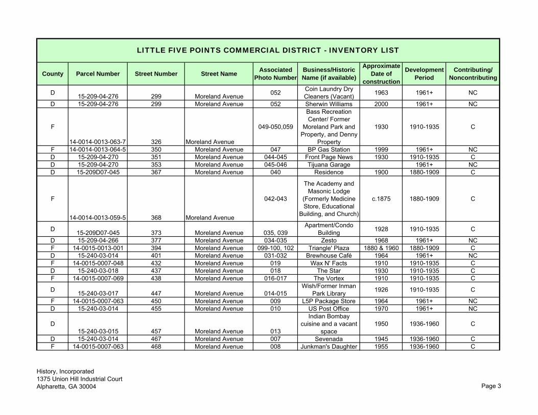
County Parcel Number Street Number Street NameAssociated
Photo NumberBusiness/Historic Name (if available)
Approximate Date of
construction
Development Period
Contributing/ Noncontributing
LITTLE FIVE POINTS COMMERCIAL DISTRICT - INVENTORY LIST
D 15-209-04-276 299 Moreland Avenue 052 Coin Laundry Dry Cleaners (Vacant) 1963 1961+ NC
D 15-209-04-276 299 Moreland Avenue 052 Sherwin Williams 2000 1961+ NC
F
14-0014-0013-063-7 326 Moreland Avenue
049-050,059
Bass Recreation Center/ Former
Moreland Park and Property, and Denny
Property
1930 1910-1935 C
F 14-0014-0013-064-5 350 Moreland Avenue 047 BP Gas Station 1999 1961+ NCD 15-209-04-270 351 Moreland Avenue 044-045 Front Page News 1930 1910-1935 CD 15-209-04-270 353 Moreland Avenue 045-046 Tijuana Garage 1961+ NCD 15-209D07-045 367 Moreland Avenue 040 Residence 1900 1880-1909 C
F
14-0014-0013-059-5 368 Moreland Avenue
042-043
The Academy and Masonic Lodge
(Formerly Medicine Store, Educational
Building, and Church)
c.1875 1880-1909 C
D 15-209D07-045 373 Moreland Avenue 035, 039Apartment/Condo
Building 1928 1910-1935 C
D 15-209-04-266 377 Moreland Avenue 034-035 Zesto 1968 1961+ NCF 14-0015-0013-001 394 Moreland Avenue 099-100, 102 Triangle' Plaza 1880 & 1960 1880-1909 CD 15-240-03-014 401 Moreland Avenue 031-032 Brewhouse Café 1964 1961+ NCF 14-0015-0007-048 432 Moreland Avenue 019 Wax N' Facts 1910 1910-1935 CD 15-240-03-018 437 Moreland Avenue 018 The Star 1930 1910-1935 CF 14-0015-0007-069 438 Moreland Avenue 016-017 The Vortex 1910 1910-1935 C
D 15-240-03-017 447 Moreland Avenue 014-015Wish/Former Inman
Park Library 1926 1910-1935 C
F 14-0015-0007-063 450 Moreland Avenue 009 L5P Package Store 1964 1961+ NCD 15-240-03-014 455 Moreland Avenue 010 US Post Office 1970 1961+ NC
D15-240-03-015 457 Moreland Avenue 013
Indian Bombay cuisine and a vacant
space1950 1936-1960 C
D 15-240-03-014 467 Moreland Avenue 007 Sevenada 1945 1936-1960 CF 14-0015-0007-063 468 Moreland Avenue 008 Junkman's Daughter 1955 1936-1960 C
History, Incorporated1375 Union Hill Industrial CourtAlpharetta, GA 30004 Page 3
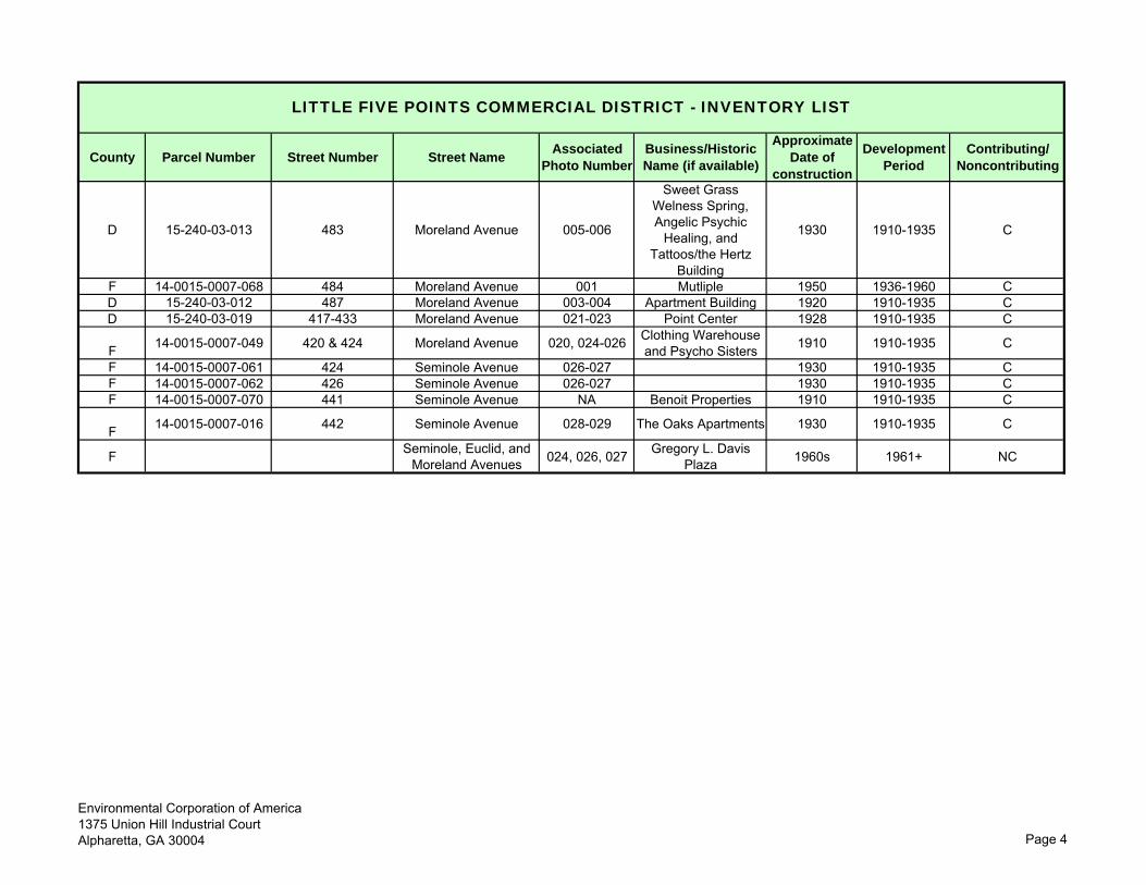
County Parcel Number Street Number Street NameAssociated
Photo NumberBusiness/Historic Name (if available)
Approximate Date of
construction
Development Period
Contributing/ Noncontributing
LITTLE FIVE POINTS COMMERCIAL DISTRICT - INVENTORY LIST
D 15-240-03-013 483 Moreland Avenue 005-006
Sweet Grass Welness Spring, Angelic Psychic
Healing, and Tattoos/the Hertz
Building
1930 1910-1935 C
F 14-0015-0007-068 484 Moreland Avenue 001 Mutliple 1950 1936-1960 C D 15-240-03-012 487 Moreland Avenue 003-004 Apartment Building 1920 1910-1935 CD 15-240-03-019 417-433 Moreland Avenue 021-023 Point Center 1928 1910-1935 C
F 14-0015-0007-049 420 & 424 Moreland Avenue 020, 024-026 Clothing Warehouse and Psycho Sisters 1910 1910-1935 C
F 14-0015-0007-061 424 Seminole Avenue 026-027 1930 1910-1935 CF 14-0015-0007-062 426 Seminole Avenue 026-027 1930 1910-1935 CF 14-0015-0007-070 441 Seminole Avenue NA Benoit Properties 1910 1910-1935 C
F 14-0015-0007-016 442 Seminole Avenue 028-029 The Oaks Apartments 1930 1910-1935 C
F Seminole, Euclid, and Moreland Avenues 024, 026, 027 Gregory L. Davis
Plaza 1960s 1961+ NC
Environmental Corporation of America1375 Union Hill Industrial CourtAlpharetta, GA 30004 Page 4
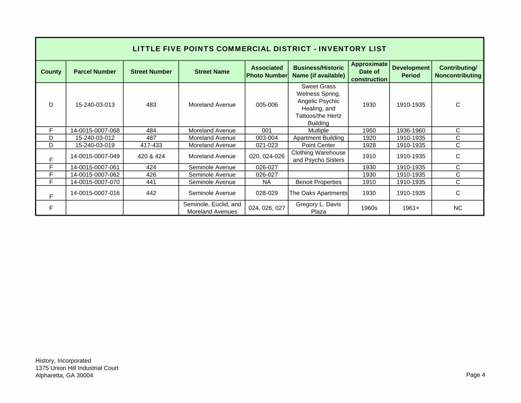
County Parcel Number Street Number Street NameAssociated
Photo NumberBusiness/Historic Name (if available)
Approximate Date of
construction
Development Period
Contributing/ Noncontributing
LITTLE FIVE POINTS COMMERCIAL DISTRICT - INVENTORY LIST
D 15-240-03-013 483 Moreland Avenue 005-006
Sweet Grass Welness Spring, Angelic Psychic
Healing, and Tattoos/the Hertz
Building
1930 1910-1935 C
F 14-0015-0007-068 484 Moreland Avenue 001 Mutliple 1950 1936-1960 C D 15-240-03-012 487 Moreland Avenue 003-004 Apartment Building 1920 1910-1935 CD 15-240-03-019 417-433 Moreland Avenue 021-023 Point Center 1928 1910-1935 C
F14-0015-0007-049 420 & 424 Moreland Avenue 020, 024-026
Clothing Warehouse and Psycho Sisters
1910 1910-1935 C
F 14-0015-0007-061 424 Seminole Avenue 026-027 1930 1910-1935 CF 14-0015-0007-062 426 Seminole Avenue 026-027 1930 1910-1935 CF 14-0015-0007-070 441 Seminole Avenue NA Benoit Properties 1910 1910-1935 C
F14-0015-0007-016 442 Seminole Avenue 028-029 The Oaks Apartments 1930 1910-1935 C
FSeminole, Euclid, and
Moreland Avenues024, 026, 027
Gregory L. Davis Plaza
1960s 1961+ NC
History, Incorporated1375 Union Hill Industrial CourtAlpharetta, GA 30004 Page 4
55
ENVIRONMENTAL | GEOTECHNICAL | WETLANDS | ECOLOGY | CULTURAL RESOURCES
Attachment 2: Photograph Log and Proof Sheets
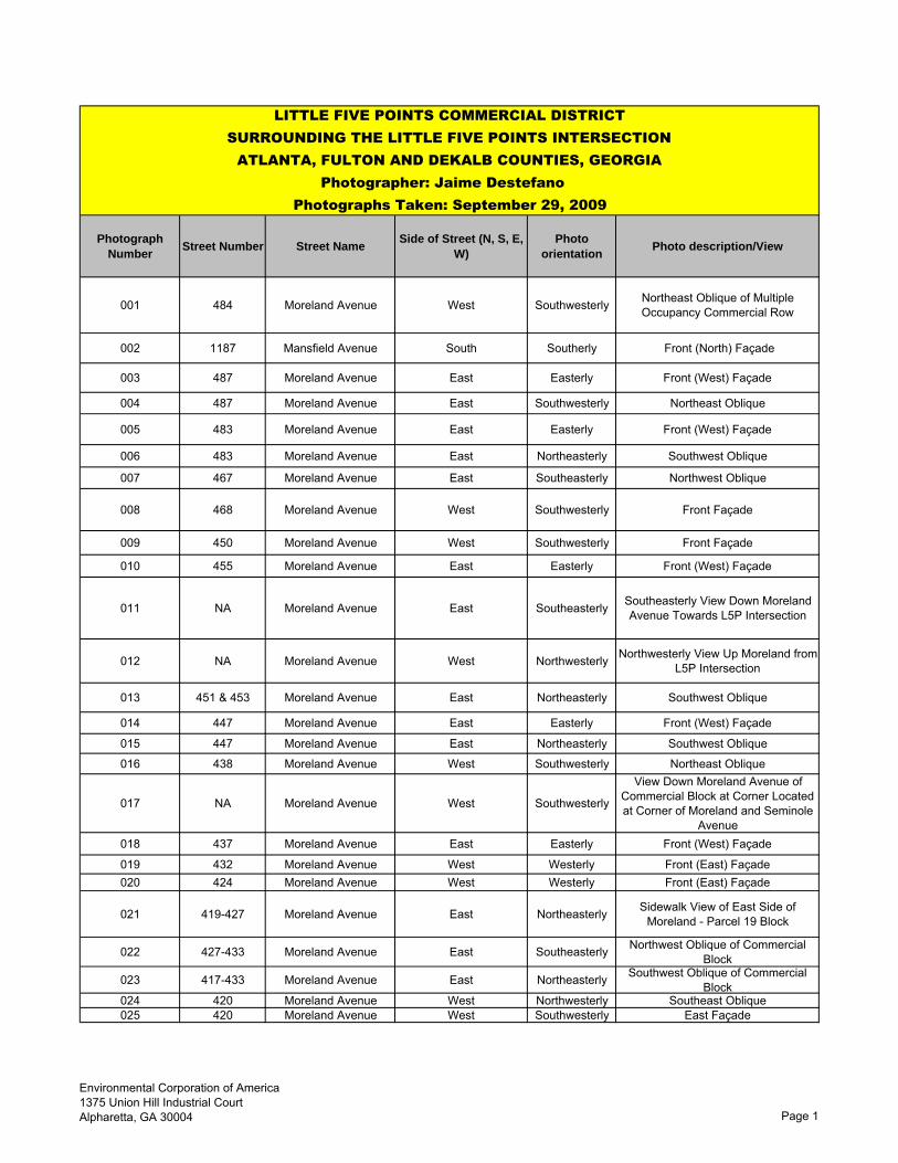
Photograph Number
Street Number Street NameSide of Street (N, S, E,
W)Photo
orientationPhoto description/View
001 484 Moreland Avenue West Southwesterly Northeast Oblique of Multiple Occupancy Commercial Row
002 1187 Mansfield Avenue South Southerly Front (North) Façade
003 487 Moreland Avenue East Easterly Front (West) Façade
004 487 Moreland Avenue East Southwesterly Northeast Oblique
005 483 Moreland Avenue East Easterly Front (West) Façade
006 483 Moreland Avenue East Northeasterly Southwest Oblique
007 467 Moreland Avenue East Southeasterly Northwest Oblique
008 468 Moreland Avenue West Southwesterly Front Façade
009 450 Moreland Avenue West Southwesterly Front Façade
010 455 Moreland Avenue East Easterly Front (West) Façade
011 NA Moreland Avenue East Southeasterly Southeasterly View Down Moreland Avenue Towards L5P Intersection
012 NA Moreland Avenue West Northwesterly Northwesterly View Up Moreland from L5P Intersection
013 451 & 453 Moreland Avenue East Northeasterly Southwest Oblique
014 447 Moreland Avenue East Easterly Front (West) Façade
015 447 Moreland Avenue East Northeasterly Southwest Oblique
016 438 Moreland Avenue West Southwesterly Northeast Oblique
017 NA Moreland Avenue West Southwesterly
View Down Moreland Avenue of Commercial Block at Corner Located at Corner of Moreland and Seminole
Avenue018 437 Moreland Avenue East Easterly Front (West) Façade
019 432 Moreland Avenue West Westerly Front (East) Façade020 424 Moreland Avenue West Westerly Front (East) Façade
021 419-427 Moreland Avenue East Northeasterly Sidewalk View of East Side of Moreland - Parcel 19 Block
022 427-433 Moreland Avenue East Southeasterly Northwest Oblique of Commercial Block
023 417-433 Moreland Avenue East Northeasterly Southwest Oblique of Commercial Block
024 420 Moreland Avenue West Northwesterly Southeast Oblique025 420 Moreland Avenue West Southwesterly East Façade
LITTLE FIVE POINTS COMMERCIAL DISTRICT SURROUNDING THE LITTLE FIVE POINTS INTERSECTION
ATLANTA, FULTON AND DEKALB COUNTIES, GEORGIA Photographer: Jaime Destefano
Photographs Taken: September 29, 2009
Environmental Corporation of America1375 Union Hill Industrial CourtAlpharetta, GA 30004 Page 1
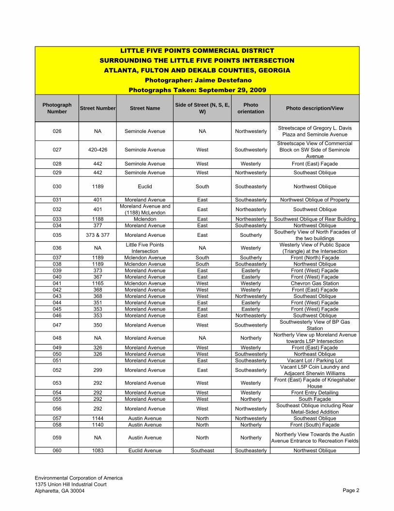
Photograph Number
Street Number Street NameSide of Street (N, S, E,
W)Photo
orientationPhoto description/View
LITTLE FIVE POINTS COMMERCIAL DISTRICT SURROUNDING THE LITTLE FIVE POINTS INTERSECTION
ATLANTA, FULTON AND DEKALB COUNTIES, GEORGIA Photographer: Jaime Destefano
Photographs Taken: September 29, 2009
026 NA Seminole Avenue NA Northwesterly Streetscape of Gregory L. Davis Plaza and Seminole Avenue
027 420-426 Seminole Avenue West SouthwesterlyStreetscape View of Commercial Block on SW Side of Seminole
Avenue028 442 Seminole Avenue West Westerly Front (East) Façade
029 442 Seminole Avenue West Northwesterly Southeast Oblique
030 1189 Euclid South Southeasterly Northwest Oblique
031 401 Moreland Avenue East Southeasterly Northwest Oblique of Property
032 401 Moreland Avenue and (1188) McLendon East Northeasterly Southwest Oblique
033 1188 Mclendon East Northeasterly Southwest Oblique of Rear Building034 377 Moreland Avenue East Southeasterly Northwest Oblique
035 373 & 377 Moreland Avenue East Southerly Southerly View of North Facades of the two buildings
036 NA Little Five Points Intersection NA Westerly Westerly View of Public Space
(Triangle) at the Intersection037 1189 Mclendon Avenue South Southerly Front (North) Façade038 1189 Mclendon Avenue South Southeasterly Northwest Oblique039 373 Moreland Avenue East Easterly Front (West) Façade040 367 Moreland Avenue East Easterly Front (West) Façade041 1165 Mclendon Avenue West Westerly Chevron Gas Station042 368 Moreland Avenue West Westerly Front (East) Façade043 368 Moreland Avenue West Northwesterly Southeast Oblique044 351 Moreland Avenue East Easterly Front (West) Façade045 353 Moreland Avenue East Easterly Front (West) Façade046 353 Moreland Avenue East Northeasterly Southwest Oblique
047 350 Moreland Avenue West Southwesterly Southwesterly View of BP Gas Station
048 NA Moreland Avenue NA Northerly Northerly View up Moreland Avenue towards L5P Intersection
049 326 Moreland Avenue West Westerly Front (East) Façade050 326 Moreland Avenue West Southwesterly Northeast Oblique051 Moreland Avenue East Southeasterly Vacant Lot / Parking Lot
052 299 Moreland Avenue East Southeasterly Vacant L5P Coin Laundry and Adjacent Sherwin Williams
053 292 Moreland Avenue West Westerly Front (East) Façade of Kriegshaber House
054 292 Moreland Avenue West Westerly Front Entry Detailing055 292 Moreland Avenue West Northerly South Façade
056 292 Moreland Avenue West Northwesterly Southeast Oblique including Rear Metal-Sided Addition
057 1144 Austin Avenue North Northwesterly Southeast Oblique058 1140 Austin Avenue North Northerly Front (South) Façade
059 NA Austin Avenue North Northerly Northerly View Towards the Austin Avenue Entrance to Recreation Fields
060 1083 Euclid Avenue Southeast Southeasterly Northwest Oblique
Environmental Corporation of America1375 Union Hill Industrial CourtAlpharetta, GA 30004 Page 2
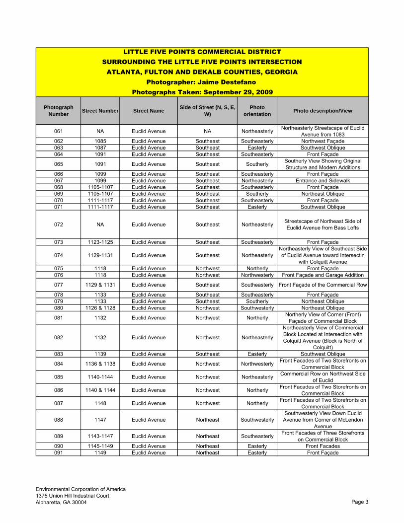
Photograph Number
Street Number Street NameSide of Street (N, S, E,
W)Photo
orientationPhoto description/View
LITTLE FIVE POINTS COMMERCIAL DISTRICT SURROUNDING THE LITTLE FIVE POINTS INTERSECTION
ATLANTA, FULTON AND DEKALB COUNTIES, GEORGIA Photographer: Jaime Destefano
Photographs Taken: September 29, 2009
061 NA Euclid Avenue NA Northeasterly Northeasterly Streetscape of Euclid Avenue from 1083
062 1085 Euclid Avenue Southeast Southeasterly Northwest Façade063 1087 Euclid Avenue Southeast Easterly Southwest Oblique064 1091 Euclid Avenue Southeast Southeasterly Front Façade
065 1091 Euclid Avenue Southeast Southerly Southerly View Showing Original Structure and Modern Additions
066 1099 Euclid Avenue Southeast Southeasterly Front Façade067 1099 Euclid Avenue Southeast Northeasterly Entrance and Sidewalk068 1105-1107 Euclid Avenue Southeast Southeasterly Front Façade069 1105-1107 Euclid Avenue Southeast Southerly Northeast Oblique070 1111-1117 Euclid Avenue Southeast Southeasterly Front Façade071 1111-1117 Euclid Avenue Southeast Easterly Southwest Oblique
072 NA Euclid Avenue Southeast Northeasterly Streetscape of Northeast Side of Euclid Avenue from Bass Lofts
073 1123-1125 Euclid Avenue Southeast Southeasterly Front Façade
074 1129-1131 Euclid Avenue Southeast NortheasterlyNortheasterly View of Southeast Side of Euclid Avenue toward Intersectin
with Colquitt Avenue075 1118 Euclid Avenue Northwest Northerly Front Façade076 1118 Euclid Avenue Northwest Northwesterly Front Façade and Garage Addition
077 1129 & 1131 Euclid Avenue Southeast Southeasterly Front Façade of the Commercial Row
078 1133 Euclid Avenue Southeast Southeasterly Front Façade079 1133 Euclid Avenue Southeast Southerly Northeast Oblique080 1126 & 1128 Euclid Avenue Northwest Southwesterly Northeast Oblique
081 1132 Euclid Avenue Northwest Northerly Northerly View of Corner (Front) Façade of Commercial Block
082 1132 Euclid Avenue Northwest Northeasterly
Northeasterly View of Commercial Block Located at Intersection with Colquitt Avenue (Block is North of
Colquitt)083 1139 Euclid Avenue Southeast Easterly Southwest Oblique
084 1136 & 1138 Euclid Avenue Northwest Northwesterly Front Facades of Two Storefronts on Commercial Block
085 1140-1144 Euclid Avenue Northwest Northeasterly Commercial Row on Northwest Side of Euclid
086 1140 & 1144 Euclid Avenue Northwest Northerly Front Facades of Two Storefronts on Commercial Block
087 1148 Euclid Avenue Northwest Northerly Front Facades of Two Storefronts on Commercial Block
088 1147 Euclid Avenue Northeast SouthwesterlySouthwesterly View Down Euclid Avenue from Corner of McLendon
Avenue
089 1143-1147 Euclid Avenue Northeast Southeasterly Front Facades of Three Storefronts on Commercial Block
090 1145-1149 Euclid Avenue Northeast Easterly Front Facades091 1149 Euclid Avenue Northeast Easterly Front Façade
Environmental Corporation of America1375 Union Hill Industrial CourtAlpharetta, GA 30004 Page 3
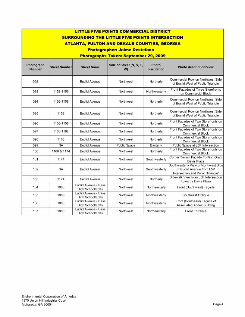
Photograph Number
Street Number Street NameSide of Street (N, S, E,
W)Photo
orientationPhoto description/View
LITTLE FIVE POINTS COMMERCIAL DISTRICT SURROUNDING THE LITTLE FIVE POINTS INTERSECTION
ATLANTA, FULTON AND DEKALB COUNTIES, GEORGIA Photographer: Jaime Destefano
Photographs Taken: September 29, 2009
092 Euclid Avenue Northwest Northerly Commercial Row on Northwest Side of Euclid West of Public Triangle
093 1152-1156 Euclid Avenue Northwest Northwesterly Front Facades of Three Storefronts on Commercial Block
094 1156-1158 Euclid Avenue Northwest Northerly Commercial Row on Northwest Side of Euclid West of Public Triangle
095 1158 Euclid Avenue Northwest Northerly Commercial Row on Northwest Side of Euclid West of Public Triangle
096 1156-1158 Euclid Avenue Northwest Northerly Front Facades of Two Storefronts on Commercial Block
097 1160-1162 Euclid Avenue Northwest Northerly Front Facades of Two Storefronts on Commercial Block
098 1168 Euclid Avenue Northwest Northerly Front Facades of Two Storefronts on Commercial Block
099 NA Euclid Avenue Public Space Easterly Public Space at L5P Intersection
100 1168 & 1174 Euclid Avenue Northwest Northerly Front Facades of Two Storefronts on Commercial Block
101 1174 Euclid Avenue Northwest Southwesterly Corner Tavern Façade fronting Grant Davis Plaza
102 NA Euclid Avenue Northwest SouthwesterlySouthwesterly View of Northwest Side
of Euclid Avenue from L5P Intersection and Pubic 'Triangle'
103 1174 Euclid Avenue Northwest Northerly Sidewalk View from L5P Intersection Towards Davis Plaza
104 1080 Euclid Avenue - Bass High School/Lofts Northwest Northeasterly Front (Southwest) Façade
105 1080 Euclid Avenue - Bass High School/Lofts Northwest Northwesterly Southeast Oblique
106 1080 Euclid Avenue - Bass High School/Lofts Northwest Northwesterly Front (Southeast) Façade of
Associated Annex Building
107 1080 Euclid Avenue - Bass High School/Lofts Northwest Northeasterly Front Entrance
Environmental Corporation of America1375 Union Hill Industrial CourtAlpharetta, GA 30004 Page 4

![[1846] five points catalogue](https://static.fdocuments.us/doc/165x107/568c35291a28ab0235932797/1846-five-points-catalogue.jpg)