LIST OF POSTER PRESENTATIONS - Wildlife Institute of India...Protected Areas in India since past 20...
35
Transcript of LIST OF POSTER PRESENTATIONS - Wildlife Institute of India...Protected Areas in India since past 20...
LIST OF POSTER PRESENTATIONS (31 August 2017 from 1000-1300h)
INTERNAL ANNUAL RESEARCH SEMINAR
S.No. Title of the Poster Presenter(s) 1. ENVIS Centre on Wildlife and Protected Areas: 20 Years
of Environmental Information Service Anant Pande
2. Distribution and Relative Abundance of Large Mammals and Impacts of Human Disturbance in and around Mehao WLS, Arunachal Pradesh
Arif Ahmad
3. Documentation and Prioritization of wetlands of Chhattisgarh
Deepan Chakravarthy
4. Conservation ecology of Oriental Darter and Little Cormorant in Bhitarkanika Conservation Area, Eastern India
N. Gokkulakannan
5. Preliminary observations on Prosopis juliflora infested areas of Ramanathapuram district, Tamil Nadu
B. Kamalakannan
6. E-bird technology (Drone) for wildlife research and management in India
Shashank Sawan
7. Assam State Biodiversity Strategy and Action Plan (2017-2030): Process and Outcomes
Niraj Kakati
8. Assessing Reintroduction Success of Gaur: Demographic Indicators
Mariyam Nasir
9. Conservation and ecology of Dugongs in Tamil Nadu Prem Jothi 10. Indicator species approach for assessment of
Outstanding Universal Value of Sahyadri sub-cluster, Western Ghats World Heritage Site
Preeti Sharma
11. Feasibility assessment of tiger augmentation/recovery in Sahyadri Tiger Reserve, Maharashtra
Shah Nawaz Jelil
12. Assessment of Socio-economic impacts and Tourism at Sahyadri (Western Ghats) World Heritage Site
Surabhi Walawalkar
13. Saving the Island Mermaids: Current status of Dugong conservation in the Andaman- Nicobar archipelago
Swapnali Gole
14. Saving Dugongs of Gujarat: Efforts so far Swapnali Gole 15. Impact of Forest Fire on Invertebrates, Reptiles and
Avifaunal Diversity in Lansdowne Forest Division: A preliminary assessment
Mona Chauhan
16. Heronries of Tamil Nadu: A Reconnaissance Frank S Jabaraj 17. Estimation of tiger density and ungulate abundance in
Bandhavgarh Tiger Reserve, Madhya Pradesh Rahul Talegaonkar and Agatha C Momin
18. Understanding population characteristics of Nilgiri Tahr for landscape genetics
Predit MA

13th Internal Annual Research Seminar, 2017
Poster Presentation Abstracts – 31st August, 2017 1
ENVIS Centre on Wildlife and Protected Areas: 20 Years of Environmental Information Service
-Anant Pande
Aim: The Environmental Information System Centre at Wildlife Institute of India with the focal theme "Wildlife and Protected Areas" was established in September 1997 by then Ministry of Environment and Forest, India. The mission of ENVIS is to support and facilitate the diverse group of stakeholders from policy makers, researchers, industries and public at national and international level through a nation-wide web enabled network.
Location: WII-ENVIS centre collates, organises and disseminates data on Wildlife and Protected Areas in India.
Methods: WII-ENVIS centre operates by information storage, retrieval and dissemination in subject areas related to wildlife science utilizing linkages with all information sources in wildlife conservation and management in the country and abroad to various stakeholders/users and provides them with authentic content. It responds to user queries by supplying substantive information in the form of published reports, documents, extracts, research papers and other unpublished and analysed information. Links with other ENVIS Centres are maintained with the ultimate objectives of identification of data and knowledge gaps in specified subject areas. Outreach efforts include publishing bulletins on thematic focus areas, awareness material on various issues related to wildlife and organizing activities with a focus on involving public in information dissemination.
Results: WII-ENVIS centre has been an important data source for information related to Wildlife and Protected Areas in India since past 20 years. The centre maintains authenticated and updated information on all categories of PAs (e.g. National Parks, Tiger Reserves, Biosphere Reserves etc.) and provides users with updated species status accounts, gazette notifications, PA maps and so on. WII-ENVIS website got over 7,00,000 hits last year with more than 8500 publications/reports downloads. It has also published 20 thematic bulletins with a focus on wide range of species and habitats of conservation concern.
Conclusion: We have recently initiated some new databases such as E-news, PA biodiversity, Geospatial information, Climate Change & Wildlife etc. Improved digital connectivity and availability of open access datasets has enabled WII-ENVIS centre to provide updated and authentic data to its users.
Project Title : WII-ENVIS Centre on Wildlife and Protected Areas
Principal Investigator(s) : Vinod. B. Mathur
Researcher(s) : Anant Pande (Senior Research Fellow)
Funding Agency : Ministry of Environment, Forest and Climate Change, Government of India
Project Duration : Continuous
13th Internal Annual Research Seminar, 2017
Poster Presentation Abstracts – 31st August, 2017 2
Distribution and Relative Abundance of Large Mammals and Impacts of Human Disturbance in and around Mehao WLS, Arunachal Pradesh
-Arif Ahmad
Aim: The present study attempts, to assess the distribution and relative abundance of large mammalian species with special reference to large carnivores (Tiger and Dhole) and their prey (Takin, Serow and Mithun) and assess the impact of human disturbance in and around Mehao Wildlife Sanctuary (WLS).
Study Area: The present study will be carried out in Mehao WLS in the Lower Dibang Valley district of Arunachal Pradesh. The sanctuary lies roughly between 93˚ 30’ and 95˚ 45’ east longitudes and 28˚ 05’ and 28˚ 15’ north latitude covering an area of 281.5 sq. km. The altitude varies from 400m to 3568m from Mean Sea Level (MSL). The forest of the sanctuary is classified as tropical evergreen forest (900m), sub-tropical and temperate forest (900m-1800m), temperate broad leave forest (1800m-2800m), temperate conifer forest (2800m-3500m).
Methods: The field study will be initiated from September 2017. To study the relative abundance and distribution of large mammals, reconnaissance survey, trail survey and camera traps (Cuddeback Model C1) will be used. A semi-structured questionnaire will be used to collect data pertaining to human-wildlife interaction and the dependence of local communities on forest resources.
Result and Conclusion: The study will provide baseline information regarding the relative abundance and occupancy of the large mammals in and around Mehao WLS. With the information obtained from the distribution of large mammals, their habitat use patterns, local people perception about large mammals this study will help in identifying key areas for large mammal’s conservation in and around the protected areas.
Keywords: - habitat use, camera traps, large mammals, Mehao, forest resources
Project Title : An Investigation of species occupancy patterns and niche differentiation among sympatric carnivores across varying land use and disturbance regimes in and around Mehao Wildlife Sanctuary, Arunachal Pradesh
Principal Investigator(s) : Gopi G.V.
Researcher(s) : Project Biologist
Funding Agency : DST, Government of India
Project Duration : 2016 - 2018
13th Internal Annual Research Seminar, 2017
Poster Presentation Abstracts – 31st August, 2017 3
Documentation and Prioritization of wetlands of Chhattisgarh
-S. Deepan Chackaravarthy & Sumit Arya
Aim: To prepare a “Brief Document” of identified wetlands for notification under Wetland Rules, 2010
Study Area: The study was carried out in the 20 wetland sites identified by the Chhattisgarh Forest Department, which are located outside the forest area, in the size range of 100 to 250 ha.
Methods: Wetland boundary was delineated using GPS and GIS tools. Field surveys were carried out in each of the identified wetlands for creating a High Conservation value (HCV) index based on ‘Framework for Monitoring of wetlands and Aquatic Systems in India’. Ecological information pertaining to birds, mammals, fishes, hydrophytes and weeds have been recorded. Analysis of spatial data to determine the overall status of the wetlands has been made. Threats to the wetlands have been categorized qualitatively. Based on the HCV and Remote sensing data, an inventory of recommendations have been created. Socio-Economic surveys have been carried out in the prioritized wetlands.
Results: A total of 89 species of birds were recorded during the survey of which 37 wetland birds belonging to 17 families and 52 terrestrial birds belonging to 28 families. Mammals recorded in the survey are Stripped Hyena, Sloth Bear and Jungle fox, Wild Boar. Thirteen major fish species were recorded in the wetlands by market based survey. Hydrophytes belong to the genus Ceratophyllum sp., Nelumbo sp. and Nymphaea sp. and major aquatic weeds are Ipomoea and hyacinth were recorded during the survey. Three wetlands have been prioritized based on the framework developed. Following National Wetland Conservation Programme Guidelines for Conservation and Management of Wetlands In India and adopting some of the international practices, recommendations would be made for general wetland conservation and special advisories for wetlands in Completely within Forest Area (CF), Completely within Revenue Area (RA) and Partially Forest or Revenue Area (PF). Socioeconomic survey shows 62.5, 33 and 4.5 percentage as Positive, neutral and negative perceptions regarding wildlife and 67 and 33 percentage as positive and neutral towards creation of ecotourism.
Keywords: High Conservation value, Wetland Delineation, Wetland Assessment, Inventory
Project Title : Prioritization and Preparation of Brief Document for notification under Wetland Rules, 2010 in Chhattisgarh
Principal Investigator(s) : Dr. Gopi G.V., Dr. K. Sivakumar, Dr. Gautam Talukdar
Researcher(s) : S. Deepan Chackaravarthy and Sumit Kumar Arya (Project Biologists)
Funding Agency : Forest Department, Government of Chhattisgarh
Project Duration : 6 months
13th Internal Annual Research Seminar, 2017
Poster Presentation Abstracts – 31st August, 2017 4
Conservation ecology of Oriental Darter and Little Cormorant in Bhitarkanika Conservation Area, Eastern India
-N.Gokulakkannan
Aim: Piscivorous aquatic birds are indicators of wetland ecosystem health and services. Populations of two such species namely Oriental Darter (Anhinga melanogaster) - a near threatened species and Little cormorant (Microcarbo niger) have declined rapidly due to pollution, hunting and other disturbances. In the present study we aim to focus on understanding their habitat use pattern, breeding biology and other factors (ie. pesticide occurrence and people perception) influencing the population of these two bird species.
Study Area: The heronry is located in the Bhitarkanika forest block of the Bhitarkanika National Park (20° 45' 42’ 38.49”N 86° 51’ 24.41” E). The approximate size of the heronry is around 3.5 sq.km.
Methodology: The fieldwork was initiated in the month of May 2017 and the breeding in the colony started by late June 2017. Focal animal sampling and scan sampling for behavioural observations are being carried out. We will use resource selection framework to study habitat use pattern, for which the study area will be divided into 2sq km grids. At each grid we will collect data on (i) bird presence and absence (ii) prey availability, (iii) weather, (iv) water depth, and (v) distance from shore.
Results: Total of 10 species were documented to nest in the heronry. Darters and little cormorants arrived in the colony on last week of June. Nest Initiation for Oriental Darter and Little Cormorant began on first week of July and clutch initiation began on 9th July for the both the species. A total count of the nests, have revealed 146 darter nests and 571 cormorant nests in the heronry. Avicennia officinalis tree species were predominantly used for nesting. Excoecaria agallocha, Avicennia officinalis, Heritiera fomes and Salacia prinoides were found to be the preferred nest materials for darter and little cormorants. Incubation period are approximately 28 days and 23 days for darter and little cormorant respectively. Breeding biology, people’s perception and occurrence of PCBs (polychlorinated biphenyl), organochlorine pesticides and heavy metal concentrations on the study species is underway.
Keywords: Heronry, Mangroves, Piscivorous birds, breeding, colonial nesting
Project Title : An assessment of breeding, foraging and habitat use patterns of a threatened piscivorous colonial nesting waterbird, Oriental darter (Anhinga melanogaster) at Bhitarkanika mangrove.
Principal Investigator(s) : Dr.Gopi G.V and Dr. Bhivash Pandav
Researcher(s) : N. Gokulakkannan (Senior Research Fellow)
Funding Agency : CSIR
Project Duration : 2 Years
13th Internal Annual Research Seminar, 2017
Poster Presentation Abstracts – 31st August, 2017 5
Preliminary observations on Prosopis juliflora infested areas of Ramanathapuram district, Tamil Nadu
-Kamalakannan B
Aim: Prosopis juliflora, a fast growing, drought resistant, evergreen exotic shrub was introduced in India including Tamil Nadu to meet the fuel wood requirements of the rural poor and to revegetate the degraded lands. Presently it is considered as one of the worst invaders in the country affecting natural ecosystems and local biodiversity. In order to eradicate this species from natural forests and to prepare the restoration plan it is desirable to assess its impact, extent and abundance of the species in Tamil Nadu. Keeping this in view, we aims to assess the extent and abundance of P. juliflora in forest, common and fallow land of Tamil Nadu .
Study area: A pilot study was conducted in seven taluks of Ramanthapuram district, Tamil Nadu.
Methods: Extent and abundance of P. juliflora in forest, common and fallow land of Tamil Nadu would be assessed using spatial data in GIS domain, and permanent sampling plots would be laid in selected agro-climatic zones to assess structure and status of vegetation including P. juliflora in different seasons. Questionnaire surveys to assess the socio-economic impacts of P. juliflora. A total of 50 transects, each with 2 km long were laid randomly in Ramanthapuram District. Each transect had six 15 m radius plots at equal distance of 400 m, to quantify the vegetation structure. Other ecological variables such as grass cover, herbs, disturbance level, pellet abundances, bird abundance, etc have also been recorded using appropriate methods on the same transect. The influence of P. juliflora on socio-economic status was assessed using questionnaire covering one village in each taluk.
Results: It was found that Rameshwaram taluk has low abundance and extent of P. juliflora compared to the other taluks in the district probably due to its isolation as this taluk is an island. Richness of native herbs was significantly lower in P. juliflora infested plots compared to non-infested plots. Relative abundances of birds such as P. cristatus, C. coturnix and A. tristis were positively correlated with Prosopis abundance in Kamuthi and Mudukulathur taluks. There was no significant difference between people who like and dislike P. juliflora in the district.
Conclusion: Preliminary analysis showed mixed impacts of P. juliflora on biodiversity and socio-economic conditions in Ramanathapuram district. Though, it had a negative impact on native flora, water table and soil texture, but positive on birds and reptiles, also livelihoods of poor.
Project Title : Study on Ecological & Socio-economic impact of invasive species, Prosopis juliflora and Lantana camara, and their removal from forest, common and fallow land of Tamil Nadu
Principal Investigator(s) : Dr. G.S. Rawat, Dr. K. Sivakumar, Dr. R. Badola and Dr. B.S. Adhikari
Researcher(s) : Kamalakannan, B. (Project Biologist)
Funding Agency : Tamil Nadu Forest Department
Project Duration : 2 years
13th Internal Annual Research Seminar, 2017
Poster Presentation Abstracts – 31st August, 2017 6
E-bird technology (Drone) for wildlife research and management in India
-Shashank Sawan
Aim: This project, conceived collaboratively by Wildlife Institute of India and National Tiger Conservation Authority, aims to (1) undertake need and feasibility analyses for integration of UAV (also known as Drone)technology in Tiger Reserves, (2) map locations of poaching and conflict prone areas, which would serve as a basis for UAV implementation, (3) experiment and implement specialized UAV units in phased manner and (4) build capacity of frontline staff for integration of UAV technology as a part of regular management efforts.
Study area: This project will be implemented in 13 Tiger Reserves across India in two phases, with Phase I (2017-2018) in Panna, Sathyamangalam, Kaziranga, Sunderbans and Corbett Tiger Reserves and Phase II (2018-2019) in Dudhwa, Melghat, Simlipal, Nagarjunasagar-Srisailam, Bandipur, Parambikulam, Ranthampore, and NamdaphaTiger Reserves.
Methods: Development of spatial data and questionnaire survey will be done to determine poaching risks and conflict potential area. Low-cost UAVs (Quadcopter and Plane) will be procured for training of project personnel and frontline staff. Specialized units of UAVs will be customized at Wildlife Institute of India and will be used for field trial, data collection and technology transfer to the forest staff of the concerned tiger reserves.
Results: Delta-wing UAVs(Caipy and Vanguard), fixed Raptor V2 and Quadcopterare currently being used for surveillance and monitoring purposes. Efforts are being made to develop hybrid aircraft i.e. Raptor V2 with Vertical Take-off and Landing (VTOL) capability and Mutirotors, integrated with thermal imaging sensors and live-streaming. So far, test flyings have been successfully completed in Panna and SathyamangalamTiger Reserves and intensive field activities have just begun.
Conclusion: Experiences from across the globe and from this recent initiative (which is first of its kind in India), UAV technology is likely to become mainstay in the field of wildlife research and conservation. This is likely to open up novel options for field managers and new avenues for business groups, which would further enable development and strengthening of technology based options and solutions for wildlife management in India.
Project Title : E-bird Technology for Tiger Conservation: Development and Integration of Un-manned Aerial Vehicles as a Surveillance and Monitoring Tool for Protection of Tiger and Capacity Building of Frontline Staff
Principal Investigator(s) : Dr. K Ramesh, Dr Vaibhav C. Mathur and Dr. A. Christy Willams
Researcher(s) : Tamali Mondal (Project Biologist), Shashank Sawan, Balsher Singh and Krishna Kumar T. (Project Engineers), Sornaraj S. Shivananthitha T. (Project Interns)
Funding Agency : National Tiger Conservation Authority, New Delhi
Project Duration : 2017 - 2019
13th Internal Annual Research Seminar, 2017
Poster Presentation Abstracts – 31st August, 2017 7
Assam State Biodiversity Strategy and Action Plan (2017-2030): Process and Outcomes
-Niraj Kakati
As a corollary to the Convention on Biological Diversity and formulation of India’s National Biodiversity Action Plan (NBAP), it is mandatory that an effective, participatory and updated NBAP is made operational at different levels of governance to meet the National Biodiversity Targets. In this context, the Assam State Biodiversity Strategy and Action Plan (ASBSAP) has been formulated under the aegis of the Assam State Biodiversity Board, Government of Assam with technical support from the Wildlife Institute of India, Dehradun. The aim of the ASBSAP is to provide guidance to carry forward the implementation of NBAP at the State level by addressing the key sectoral and thematic aspects of sustainable use, conservation and management of biodiversity in Assam.
Assam is situated in the northeastern region of India and is a constituent unit of the Eastern Himalayan Biodiversity Region - one of the two ‘Biodiversity Hotspots’ in the country. Its climatic condition and varied physiography is responsible for its rich and unique biodiversity.
The document was prepared by using a combination of desktop review, expert opinion and primary stakeholder consultation workshops at the State and sub-regional levels during the project period from July 2016-July 2017. This was followed by gap analysis and threat ranking to identify specific strategies and actions to address the issues.
Assam’s biological diversity is classified into key sectoral areas with suggested strategy and actions on conservation and management of wild (flora, fauna, habitats) and domesticated biodiversity (agro-biodiversity, plantations, homestead gardens, sericulture, livestock, fisheries), urban-ecosystems, micro-organisms among others. Strategies for each of these sectors also complement the action points under 12 National Biodiversity Strategies.
Keywords: CBD, NBT, NBAP, Assam, Biodiversity
Project Title : Assam State Biodiversity Strategy and Action Plan
Principal Investigator(s) : Dr. V.B. Mathur and Dr. Sonali Ghosh
Researcher(s) : Niraj Kakati (Technical Officer), Anukul Nath (Assistant Technical Officer), Persis Farooqy (World Heritage Assistant), Mamatha Prasad (Project Fellow), Nazrul Islam (Project Fellow)
Funding Agency : Assam State Biodiversity Board, Government of Assam
Project Duration : 2016 - 2017
13th Internal Annual Research Seminar, 2017
Poster Presentation Abstracts – 31st August, 2017 8
Assessing Reintroduction Success of Gaur: Demographic Indicators
-Mariyam Nasir
Aim: The Gaur (Bos gaurus gaurus) became locally extirpated in Bandhavgarh Tiger Reserve (BTR) in 1998. As a population building exercise 50 (14:36) individuals were translocated between 2011 and 2012 from Kanha Tiger Reserve as a joint initiative between Madhya Pradesh Forest Department, Wildlife Institute of India and &Beyond. The present study was undertaken to assess the success of reintroduction using demographic parameters over the last 6 years.
Location: BTR lies on the extreme north-eastern border of the Madhya Pradesh closer to the Satpura ranges (23°27' 00” to 23°59'50” N and 80°43'15” to 81°15'45” E) and holds a diverse habitat ranging from moist peninsular low level Sal forest to dry grassland. The protected area comprises of Bandhavgarh National Park (452.66 km2) and Panpatha Wildlife Sanctuary (264.23 km2) besides the notified buffer area of 820.03 km2. The reintroduced gaur primarily inhabits the National Park.
Methods: Life table analysis was carried out to determine the population vital rates (growth rate, sex ratio, mortality, cow/calf ratio) and age distribution using demographic parameters from 2012 to 2017 and the values compared with those resulting from Population Viability analysis (PVA) run prior to reintroduction.
Results: The observed mean growth rate was 0.059 and was higher (0.045) as compared to thatprojected at the time of reintroduction The observed sex ratio of 1:2.33 in the study was also higher as compared to the predicted ratio of 1:1.23. The values for actual mortality rates and cow/calf ratio of the reintroduced population were 3.22 and 1:2.52 respectively. The present population grew to 103 individuals over the 6 years period and was higher compared to projected population of 89 at the end of sixth year.
Conclusion: The study revealed that the reintroduced population of gaur is growing and exhibits higher values of vital rates as compared to the predictive models used to establish the population and may be attributed to intensive management, initiatives towards habitat restoration following village relocation and effective monitoring and protection.
Key Words: Reintroduction, Life Table, Population Viability Analysis
Project Title : Monitoring of Reintroduced Gaur in Bandhavgarh Tiger Reserve- Phase II
Principal Investigator(s) : Dr. Parag Nigam (Principal Investigator), Dr. Bilal Habib,Qamar Qureshi (Co-Investigators) and Dr. K. Sankar (SACON)
Researcher(s) : Dr. Navanethan B. (Senior Research Fellow and Mariyam Nasir (Junior Research Fellow)
Funding Agency : Madhya Pradesh Forest Department
Project Duration : 2015 - 2018
13th Internal Annual Research Seminar, 2017
Poster Presentation Abstracts – 31st August, 2017 9
Conservation and ecology of Dugongs in Tamil Nadu
-PremJothi P.V.R
Aim: Recovering dugongs entails targeted, multidisciplinary research that flows into management actions and advocacy for policy changes. Therefore, dugong recovery program aims at: (a) monitoring Dugong population and habitat status; (b) implementing site specific management actions to recover populations and restore critical habitats; (c) incentivizing participatory conservation efforts involving local stakeholders; and (d) improving the capacity of management agencies to promote protection of Dugong.
Study area: In India, the Palk Bay has landmarks between the Point Calimere and Rameshwaram Island. This area has luxuriant seagrass growth because of the topography and sediment texture. The Palk Strait and the Gulf of Mannar are important areas for dugongs in India where the present study was conducted.
Results: Awareness meetings were conducted with support of State Forest and Fisheries departments in the four major fishing villages in Palk bay with about 200 local fisher-folk. Dugong mortality due to net entanglement was high in Palk Bay. However, our local stakeholders rescued and released back two entangled dugongs for the first time in India
As part of ‘Incentive for Conservation Programme’, examinations have been conducted for school children of fishermen community in Ramnathapuram, Pudukottai and Thanjavur districts. Selected ‘Dugong ambassadors’ would be supported with ‘Dugong Scholarship’ of 500/month for two years.
Seagrass samples have been collected to analyze the heavy metal contents as a response to growing pollution level and understand the nutrient qualities. Further, genetic samples have been collected from the stranded dugongs to study their genetic diversity and relatedness with global populations.
Moreover, awareness programs conducted with ‘Arumbugal Trust’ in ‘Climate Change Science Express’ educated around 25000 school children about conservation of marine biodiversity including dugongs. A stakeholder’s consultation was organized to develop the next Management Plan of Gulf of Mannar National Park as part of this project. About 40 officials and experts from various research institutions and departments have participated in this workshop.
Conclusion: Two dugongs have been rescued from fishing nets and released back to sea successfully. A total of 50 Dugong Ambassadors of School going children have been selected.
Keywords: Dugong ambassadors, Dugong scholarship, Seagrass
Project Title : Recovery of Dugongs and their habitats in India: An integrated participatory approach
Principal Investigator(s) : Dr. K. Sivakumar, Dr. J.A. Johnson (Principal Investigators), Dr. Samrat Mondal, Dr. K. Ramesh, and Dr. Parag Nigam (Co-Investigators)
Researcher(s) : P.V.R. Prem Jothi (Project Fellow), Swapnali Gole (Project Fellow), Devanshi Kukadia (Project Fellow), Dr. N. Marimuthu (Project Scientist)
Funding Agency : CAMPA
Project Duration : 5 years
13th Internal Annual Research Seminar, 2017
Poster Presentation Abstracts – 31st August, 2017 10
Indicator species approach for assessment of Outstanding Universal Value of Sahyadri sub-cluster, Western Ghats World Heritage Site
-Preeti Sharma
Aim: To assess the distribution and device monitoring protocol of select indicator species of Sahyadri (Sub-cluster) Western Ghats WHS
Location: Sahyadri sub-cluster (area=1026.6 sq. km) comprises of Kas plateau, Chandoli NP, Koyna and Radhanagri WLS and forms the northern most limit of the Western Ghats WHS in Maharashtra.
Methods: Direct sightings were recorded for Ratufa indica (N=333), and Columba elphinstonii (N=51) along 2 km line transects and forest trails in the study area. Maxent (presence-only SDM) software was used to develop habitat suitability model using 12 environmental variables along with elevation data. For Xanthophryne sp. lateral photographic data (N= 558) for 151 and 35 toads of X. tigerinus and X. koynanensis respectively were collected. HotSpotter, open source software to identify individual animals was used for validating the individual identification method for X. tigerinus. Results: Ratufa indica, and Columba elphinstonii showed a highly patchy occurrence with most suitable habitats limited inside the PAs. However, presence records are found outside PA showing habitat use beyond the PA boundary. This study also provided new records for the occurrence of Xanthrophyryne sp. in areas that were perhaps previously unsurveyed.
Conclusions: A simple field-based sampling and monitoring protocol that can be easily replicated by the forest frontline staff is proposed. The fragmented occurrence of sentinel species within the PAs indicates the urgency to restore and maintain the connectivity between the PAs for long term survival of such species.
Keywords: Indicator species, Species distribution modeling, Xanthphryne, Outstanding Universal Value, Sahyadri, World Heritage Site
Project Title : Evaluating Outstanding Universal Values of Western Ghats (Sahyadri sub cluster) for Provisioning and Regulating ecosystem services in the region
Principal Investigator(s) : Ben V. Clement (Principal Investigator), Sonali Ghosh (Co-Investigator), Vinod B. Mathur (Advisor)
Researcher(s) : Preeti Sharma (Project Biologist)
Funding Agency : Sahyadri Tiger Conservation Foundation
Project Duration : 1 year
13th Internal Annual Research Seminar, 2017
Poster Presentation Abstracts – 31st August, 2017 11
Feasibility assessment of tiger augmentation/recovery in Sahyadri Tiger
Reserve, Maharashtra
-Shah Nawaz Jelil
The major objectives of this study were to assess: (a) carnivore presence in the area, (b) prey base and (c) habitat condition.
Sahyadri Tiger reserve (STR), situated in the North-western Ghats, has been formed by combining Chandoli National Park and Koyana Wildlife Sanctuary in Maharashtra. It is among the low density tiger areas, but the Government of Maharashtra plans to augment tiger population in the reserve.
We carried out a combination of field methods to address the objectives and these were sign survey (n = 72, 384.5 km), camera trapping (n = 142, 2219 trap nights), line transect sampling (n = 41, 82 km), vegetation quantification (n = 369 plots). Field work was carried out from April to June 2017, covering all the ranges in STR. Remote Sensing and GIS tools were also deployed to map landscape characteristics.
Results: A total of 10 carnivore species were recorded based on sign survey and camera trap sampling, but tiger presence could not be established. Camera trap capture rate was maximum for sloth bear (0.022/trap night) and it was lowest for grey mongoose (0.0003/trap night). Wild ungulate density was found to be 9.5 (2.79 SE) per km2, livestock density was 10.81 (6.00 SE) per km2 and primate density was 11.18 (5.00 SE) per km2. As for habitat condition, tree density was 14.93 (±7.72 SD) per plot, canopy cover 54.31% (± 9.20 SD) per plot, cutting signs 0.13 (± 0.31 SD) per plot, lopping signs 0.32 (± 0.46 SD) per plot and livestock dung density 0.76 (± 0.73 SD) per plot.
Conclusion: Our results suggest that there is no resident tiger population in STR and even if few individuals had escaped from our sampling, it will be precariously low. Given the low number or local extinction, and the habitat suitability including moderate prey base, tiger augmentation would be required to ensure viable tiger population in STR. The information generated from this study would be used as the basis for estimating carrying capacity of tiger population and Population Viability Analysis towards effective tiger recovery program in STR.
Keywords: Camera trapping, line transect, reintroduction, augmentation, North-western Ghats
Project Title : Tiger Recovery Strategy and Long-term Monitoring in Sahyadri Tiger Reserve, Maharashtra
Principal Investigator(s) : Dr. K. Ramesh, Dr. V. Clement Ben, Dr. Sonali Ghosh, Dr. Gopi G. V., Mr. Hemant Kamdi, Dr. Anish Andheria
Researcher(s) : Shah Nawaz Jelil, Avinash A. Gaykar, Goutham Choutri Raja A., (Project Fellows), Kamana Pokhariya, Rabi Sankar Pal (Project Assistants) and Nazrukh Sherwani, (Project Interns)
Funding Agency : Sahyadri Tiger Foundation, Maharashtra
Project Duration : 2016-2021
13th Internal Annual Research Seminar, 2017
Poster Presentation Abstracts – 31st August, 2017 12
Assessment of Socio-economic impacts and Tourism at Sahyadri
(Western Ghats) World Heritage Site
-Surabhi Vidyadhar Walavalkar
Aim: To understand the socio-cultural changes in the landscape since the inscription of the site as world heritage and to assess tourism benefits at WHS
Location: Sahyadri sub-cluster comprises of Kas plateau, Chandoli National Park, Koyna and Radhanagri Wildlife Sanctuary and forms the northern most limit of the Western Ghats World Heritage Site in Maharashtra. The total area of the study site is 1026.22 sq. km
Methods: Questionnaire surveys to document the consumptive and non-consumptive benefits derived from the PA in a total of 41 forest fringe and core villages. Semi-structured interviews were conducted with tourists, resort owners, forest officials and staff (N= 328) to assess the awareness and perception of key stakeholders for recreational values of 3 most popular tourism spots (Chandoli NP, Ozarde waterfall; Koyna WLS, Kas plateau).
Result: Status and trends of food, medicinal plants, fodder, drinking water, irrigation water, construction material, flood control and spiritual beliefs, recreational benefits were obtained from the WHS. Due to increased regulation and enforcement of forest laws peoples’ dependency on forest resources has decreased. Yet, 27 out of 43 villages disapprove for relocation. Preliminary results show negative impacts of increased tourism in WHS such as Kas plateau. However, willing to pay more for conservation was documented amongst the tourists if it enhanced the experience.
Conclusion: Dependency on forest produce is gradually decreasing as people have moved to alternate livelihoods. However, village relocation cannot be considered desirable for all the villages. Awareness generation on Outstanding Universal Value of the landscape can address unregulated tourism at WHS.
Project Title : Evaluating the Outstanding Universal Values of Western Ghats (Sahyadri sub-cluster) for Ecosystem services in the region
Principal Investigator(s) : Dr. Clement Ben, Dr. Sonali Ghosh and Dr. V.B. Mathur
Researcher(s) : Surabhi V Walavalkar (Project Biologist)
Funding Agency : Sahyadri Tiger Conservation Foundation
Project Duration : 1 year
13th Internal Annual Research Seminar, 2017
Poster Presentation Abstracts – 31st August, 2017 13
Saving the Island Mermaids: Current status of Dugong conservation in the Andaman- Nicobar archipelago
-Swapnali Gole
Aim: In India, the Andaman and Nicobar archipelago harbors the second highest population of the vulnerable marine mammal Dugong (Dugong dugon), first being the Palk Bay- Gulf of Mannar in Tamil Nadu. Dugong biology in Indian waters remains poorly understood with huge research gaps on their movement patterns, home ranges, and breeding biology. A recent CAMPA funded research project by the WII on the recovery of Dugongs and their habitats is a novel initiative to fill these gaps. The present study aimed to understand region-specific threats to Dugongs and their habitats, through interaction with local communities which are the primary stakeholders.
Study area: So far, Dugongs are known to inhabit four pockets throughout the archipelago namely, Diglipur-Mayabunder in the North Andaman, Havelock-Neil Islands in the Ritchie’s archipelago, Hutbay in the South Andaman and the Nicobar Islands. The preliminary social surveys were conducted in the North, Middle and South Andaman Islands and the Great Nicobar Island whereas awareness programs were conducted to sensitize people in Neil and Havelock Islands.
Methods: Semi-structured questionnaire surveys with fishermen, commercial divers and game fishers were conducted. The study aimed to assess habitats used by Dugongs, locals’ perception towards Dugong conservation and their dependency on seagrass habitats. Further, to support education of fishermen children in the Dugong inhabited regions; ‘Dugong Scholarship program’ was conducted in schools covering students of 8thto 11th standard of the Havelock and Neil Islands. During this awareness program, the students were educated about the Island biodiversity, marine ecosystems, Dugongs and seagrasses. Results and Conclusion:
Based on 53 interviews (n=48 Fishermen, n=5 Divers/ Game Fishers), the study revealed the habitats frequently used by Dugongs. Further, the traditional fishermen showed a preference for coral reefs over seagrass habitats thus, minimizing direct fishing pressures on Dugong habitats. The maiden ‘Dugong Scholarship Program’ aimed to create awareness amongst the fishermen students on the issues imperative to Dugong conservation. In future, the fishermen folks will be sensitized through community workshops and included in the Dugong monitoring program.
Key words: Dugong ambassadors, Dugong scholarship, Seagrass habitats
Project Title : Recovery of Dugongs and their habitats in India: An integrated participatory approach
Principal Investigator(s) : Dr. K. Sivakumar, Dr. J.A. Johnson (Principal Investigators), Dr. Samrat Mondol, Dr. K. Ramesh and Dr. Parag Nigam (Co-Investigators)
Researcher(s) : Swapnali Gole, P.V.R. Prem Jothi and Devanshi Kukadia (Project Fellows), Dr. N. Marimuthu (Project Scientist)
Funding Agency : CAMPA
Project Duration : 5 years
13th Internal Annual Research Seminar, 2017
Poster Presentation Abstracts – 31st August, 2017 14
Saving Dugongs of Gujarat: Efforts so far
-Swapnali Gole
Aims: Gujarat coast forms one of the most crucial maritime zones in India, and being a development hub, has received a bad hit over the years of industrialization and detrimental coastal activities. Despite this, the Gulf of Kutch and Kambhat harbor a promising marine life, which is been pushed on the brink of extinction including species like Dugong. The Dugong recovery program aims at: (a) assessing and monitoring Dugong population and habitat status; (b) implementing site specific management actions to recover populations and restore critical habitats; (c) incentivizing participatory conservation efforts involving local stakeholders; and (d) improving the capacity of enforcement and management agencies to promote integrated protection and management of Dugong and associated species.
Study area: The Gulf of Kutch is situated in the Arabian Sea and the Southern coast of the Gulf harbors seagrass habitats, which form primary diet for the vulnerable marine mammal Dugong (Dugong dugon), whose distribution is sporadic in Indian waters. The present study was carried out in selective schools in the Gulf region.
Methods: As a part of the project, an awareness program was conducted at five different schools at the Okhamandal range, Gujarat. In this effort, awareness was spread about the marine ecosystems like Seagrass, Coral Reefs, and Mangroves using a representation model and further their linkages were explained. To support the education of fishermen kids’ dependent on seagrass habitats, the Dugong Scholarship program was conducted for around 160 children at Dwarka and Khambaliya Senior Secondary schools. Fifty students selected on merit basis, will be awarded the scholarship for the next two years. Lastly, owing to the industrial hit this coast has received, seagrass samples have been collected to analyze the heavy metal content.
Results and Conclusion: A total of 50 school going children of fishermen communities have been selected as ‘Dugong Ambassadors’. The awareness programmes proved to be quite productive in terms of knowledge dissemination to the local masses, which is extremely important in conservation. Our work focused not only on Dugong awareness but also on the general biodiversity of Gujarat and the need to protect it.
Keywords: Gulf of Kutch, Conservation, Scholarship Program
Project Title : Recovery of Dugongs and their habitats in India: An integrated participatory approach
Principal Investigator(s) : Dr. K. Sivakumar, Dr. J.A. Johnson (Principal Investigators), Dr. Samrat Mondal, Dr. K. Ramesh and Dr. Parag Nigam (Co-Investigator)
Researcher(s) : Devanshi Kukadia, Swapnali Gole and P.V.R. Prem Jothi (Project Fellows), Dr. N. Marimuthu (Project Scientist)
Funding Agency : CAMPA
Project Duration : 5 years
13th Internal Annual Research Seminar, 2017
Poster Presentation Abstracts – 31st August, 2017 15
Impact of Forest Fire on Invertebrates, Reptiles and Avifaunal Diversity in Lansdowne Forest Division: A preliminary assessment
-Mona Chauhan
Aim: Identification of fire prone areas and establishment of sampling sites to assess the impact of forest fires on insects, herpetofauna and birds in Lansdowne forest division and documentation of baseline ecological information (distribution, abundance status) on insects, herpetofauna and birds in fire prone areas and previously burnt areas.
Location: This study has been conducted in Lansdowne forest division of Uttarakhand.
Methodology: Study area has been stratified on the basis of elevation, habitat and vegetation types to explore the faunal diversity along each gradient. Five representative hectare plots (100×100m) has been identified and permanently marked in each range of Lansdowne forest division. Standardized methods of insect collection viz; hand sorting, pitfall trapping, light trapping and vegetation beating have been used to collect insects. Soil sampling has been done to collect nematodes from plots. Vegetation sampling has been done to know the vegetation structure. 10m radius circular plot for tree species, shrub species in 5m radius circular plot, regenerating tree species, grass and herb species have been counted in quadrates of 1×1m dimension within each 10m circular plot within each plot. Point Count method has been used to record bird species. For reptiles pitfall trapping and visual encounter have been done. Topographic information has been recorded by using GPS.
Results: A total of 1337 morphospecies of invertebrates were collected from study area representing 10 orders of class Insecta and 4 orders, 17 family of class Arachnida. Among insect taxa the most abundant order was Hymenoptera (393 individuals: 42.95%) followed by Hemiptera (215: 23.49%) and Dictyoptera (101: 11.03%). The least abundant order was Thysanura (1: 0%), Phasmida (2: 0%) and Dermaptera (7: 0.1%). A total of 19 species of trees, 34 species of shrubs and 24 species of herbs were collected from the study area. A total of 16 tree families, 21 shrub families and 13 herb families were obtained. The most abundant families for tree species are Myrtaceae (10.53%), Fabaceae (10.53%) and Combretaceae (10.53%). The most ubiquitous family for shrub species is Fabaceae (11.76%) and the most abundant family for herb species is Asteraceae (16.67%). We have identified 23 different species of amphibia and reptiles that include frogs, lizards, skinks, snakes, Himalayan rock agama, monitor lizard and tortoise. Total 106 individuals were recorded from all the sampling locations of different five ranges. Asian elongated tortoise (Indotestudo elongate) is the only endangered species that was recorded among all. Total 123 species of birds have been identified. Red-vented bulbul (Pycnonotus cafer) and purple Sunbird (Nectarinia asiatica) were the most observed species.
Key words: forest fire, endangered, ecosystem, vulnerability
Project Title : Impact of Forest Fire on Invertebrates, Reptiles and Avifaunal Diversity in Uttarakhand
Principal Investigator(s) : Dr. V.P. Uniyal, Dr. R. Suresh Kumar, Dr. Abhijit Das
Researcher(s) : Mona Chauhan (Project Biologist), Sarbjeet Kaur Narula (Project Assistant) and Susmita Khan (Project Assistant)
Funding Agency : Uttarakhand Forest Department
Project Duration : 2017-2018
13th Internal Annual Research Seminar, 2017
Poster Presentation Abstracts – 31st August, 2017 16
Heronries of Tamil Nadu: A Reconnaissance
-D.Frank Sadrack Jabaraj
Aim: Colonial nesting waterbirds face major risks to their populations, habitats and critical areas. Our study as part of national atlas of colonial nesting waterbirds aims to strengthen the knowledge base by conducting a state wide survey in Tamil Nadu on the colonial nesting waterbirds and investigate the threats associated with each nesting colony.
Study Area: The present study covers the entire state of Tamil Nadu, which is divided into three broad physiographic regions western hilly region, plains along the coast, northwestern high elevation area. The state comprises of 17 river basins, 61 major reservoirs and 40,000 tanks.
Methods:Information pertaining to nesting area, activity period in the nesting site, nest trees used, nesting species, number of nests, conservation threats and determinants of species diversity would be collected during the nesting season. Detailed photo documentation of these nesting sites and species would also be done to be showcased in the atlas. A questionnaire survey would be conducted by circulating pre-set questionnaire to eminent bird scientists, birdwatchers, naturalists, forest departments and NGOs across the state to ascertain the current locations of the breeding colonies.
Results: Around 90 sites have so far been identified as potential nesting sites during (mid-June – July, 2017). Of the 90 sites, 16 sites were found to be in the Protected Areas and rest of the sites outside Protected Areas. Some of the major waterbird nesting colonies viz., Koonthankulam, Vedanthangal, Udayamarthandapuram, Vettangudi, Karaivetti, Point Calimere etc. has been documented as part of reconnaissance survey. These include both already existing sites along with new ones. Currently no nesting activities are present as the nesting starts after the onset of North East monsoon i.e from October to December. The atlas is aimed at documenting the key colonial nesting waterbirds area occurring in Tamil Nadu and assessing the status of the nesting species and the sites. The major outcome of the study would provide a detailed assessment of important colonies and the conservation threats.
Keywords: Colonial, Nesting, Atlas, Conservation, Waterbirds.
Project Title : Atlas of Colonial nesting waterbirds in the east coast states of India
Principal Investigator(s) : Dr. Gopi G.V and Dr. Bivash Pandav
Researcher(s) : D. Frank Sadrack Jabaraj (Junior Research Fellow)
Funding Agency : WII (Grant in Aid)
Project Duration : 2 years
13th Internal Annual Research Seminar, 2017
Poster Presentation Abstracts – 31st August, 2017 17
Estimation of tiger density and ungulate abundance in Bandhavgarh Tiger Reserve, Madhya Pradesh
-Rahul Talegaonkar and Agatha C Momin
Aim: To study the abundance and distribution of tigers and ungulates in Bandhavgarh Tiger Reserve.
Location: The protected area comprises of two conservation units, Bandhavgarh National Park (442.842 km2) and the Panpatha Wildlife Sanctuary (245.842 km2).
Methods: A total of 375 camera traps were used, with a total effort of 33,750 trap nights. Camera trapping was done in two blocks, which included 9 ranges. Tiger abundance data was analysed using spatially explicit capture recapture (SECR) method in R software. Simultaneously, we used line transect to determine the density of principal tiger prey populations which were estimate using DISTANCE software. A total of 142 transects were walked with a total effort of 852kms.Our transect lines sampled the same areas in which we set our camera traps.
Results: Density of tigers (>1.5 year old) was estimated to be 3.93 ± 0.4 individuals/100 km2. We were able to identify 65 adult tigers and 12 cubs from the photographs. Density of Chital (n=701) was estimated to be 58.3 (SE ± 5.02), Sambar (n=187) 7.5 (SE ± 1), Nilgai (n=88) 10.5 (SE ± 1.62) and Wild Pig (n=92) 6.8 (SE ± 1.142) in the 8 ranges of the tiger reserve. There are 12 villages in the core area of Bandhavgarh which are yet to be relocated.
Conclusion: The ungulates presence was high in the core as compared to the buffer. Chital had the highest density among the ungulates in the core. Wild Pig had the highest density in the Buffer. 142 incidents of Human- Wildlife Conflicts (107 Human Injury and 11 Human death) in the year 2014 - 2016 and 24 Tiger deaths (2009 to 2014) were reported by Forest department. Our study contributes to the general understanding of how the predator and prey species are distributed in the park.
Project Title : Ecology of tigers with special reference to ranging patterns, dispersal and human tiger conflict in Bandhavgarh Tiger Reserve, Madhya Pradesh
Principal Investigator(s) : Qamar Qureshi and Dr. Parag Nigam
Researcher(s) : Rahul Talegaonkar (Senior Project Biologist)
Funding Agency : Madhya Pradesh Forest Department
Project Duration : 3 years
13th Internal Annual Research Seminar, 2017
Poster Presentation Abstracts – 31st August, 2017 18
Understanding population characteristics of Nilgiri Tahr for landscape genetics
-Predit M A
Aim: Understanding the population characteristics (age and sex categories) in landscape genetics studies is crucial to determine the extent of dispersal in adjoining population. Obtaining such information for Nilgiri Tahr by direct observation is difficult in the areas with steep slopes and high ruggedness. Therefore, we used faecal pellet measurements to categorise into broad age class in relation to habitat characteristics.
Study area: Five distinct conservation blocks were identified in the Western Ghats from the previous study on Nilgiri Tahr, and we completed field work in the four conservation blocks.
Methods: Field surveys were done in four conservation blocks and collected around 1266 different groups of faecal pellets. We have also noted the location, altitude and micro habitat for each sample collected. An earlier study on Nilgiri Tahr documented that width measurements of pellets may be used to characterize broad age categories; however, they excluded the use of pellet weight. We validate the significance of using pellet weight to classify age categories.
Results: We observed a high correlation coefficient (r=0.89) between width and weight of the pellet and regression equation was determined. Based on these criteria, it was possible to classify pellets into three broad age categories, i.e., young, sub-adult and adults. Our data analysis of Anamalai Tiger Reserve (ATR) in block three indicates normal distribution patterns of pellet weight (n=67) and 18 percent samples were of sub-adult individuals. Whereas, In Kalakkad and Mundanthurai Tiger Reserve (KMTR) of conservation block 5, only 5 percent samples (n=93) were of sub-adult. 68 per cent of samples were between 500 and 1500 m altitude in ATR whereas it was between 1000 and 1500 m altitude in KMTR. We expect the differential use of altitude may have some impact on their dispersal ability.
Discussion: We expect a high probability of animal dispersal from the ATR of the Block three than the KMTR of block five because of differential use of altitude and observed differences in age categories. This will be assessed using genetic approaches. We will assess these characteristics in other identified conservation blocks to determine the extent of the dispersal ability of the individuals.
Keywords: Nilgiri Tahr, faecal pellet measurements, dispersal, Anamalai Tiger reserve, Kalakkad Mundanthurai Tiger Reserve
Project Title : Population genetic structure of the Nilgiri Tahr (Hemitragus hylocrius) in Western Ghats, India; Conservation and Forensic Implications
Principal Investigator(s) : Dr. Bivash Pandav, Dr. S. P. Goyal and Dr. Parag Nigam
Researcher(s) : Predit M.A. (Senior Research Fellow) and Dr. Bheem Dutt Joshi (Research Associate)
Funding Agency : Department of Biotechnology, Government of India
Project Duration : 2015 - 2018

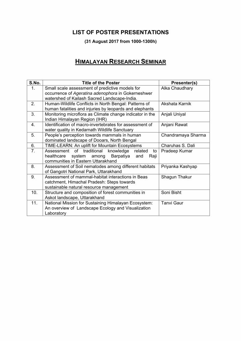
LIST OF POSTER PRESENTATIONS (31 August 2017 from 1000-1300h)
HIMALAYAN RESEARCH SEMINAR
S.No. Title of the Poster Presenter(s) 1. Small scale assessment of predictive models for
occurrence of Ageratina adenophora in Gokerneshwer watershed of Kailash Sacred Landscape-India.
Alka Chaudhary
2. Human-Wildlife Conflicts in North Bengal: Patterns of human fatalities and injuries by leopards and elephants
Akshata Karnik
3. Monitoring microflora as Climate change indicator in the Indian Himalayan Region (IHR)
Anjali Uniyal
4. Identification of macro-invertebrates for assessment of water quality in Kedarnath Wildlife Sanctuary
Anjani Rawat
5. People’s perception towards mammals in human dominated landscape of Dooars, North Bengal
Chandramaya Sharma
6. TIME-LEARN: An uplift for Mountain Ecosystems Charuhas S. Dali 7. Assessment of traditional knowledge related to
healthcare system among Barpatiya and Raji communities in Eastern Uttarakhand
Pradeep Kumar
8. Assessment of Soil nematodes among different habitats of Gangotri National Park, Uttarakhand
Priyanka Kashyap
9. Assessment of mammal-habitat interactions in Beas catchment, Himachal Pradesh: Steps towards sustainable natural resource management
Shagun Thakur
10. Structure and composition of forest communities in Askot landscape, Uttarakhand
Soni Bisht
11. National Mission for Sustaining Himalayan Ecosystem: An overview of Landscape Ecology and Visualization Laboratory
Tanvi Gaur
2nd Himalayan Research Seminar, 2017
Poster Presentation Abstracts – 31st August, 2017 1
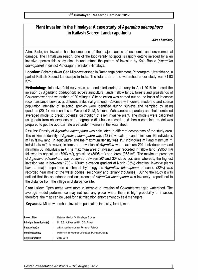
Plant invasion in the Himalaya: A case study of Ageratina adenophora in Kailash Sacred Landscape-India
- Alka Chaudhary
Aim: Biological invasion has become one of the major causes of economic and environmental damage. The Himalayan region, one of the biodiversity hotspots is rapidly getting invaded by alien invasive species this study aims to understand the pattern of invasion by Kala Bansa (Ageratina adenophora) in district Pithoragarh, Western Himalaya.
Location: Gokarneshwar Gad Micro-watershed in Ramganga catchment, Pithoragarh, Uttarakhand, a part of Kailash Sacred Landscape in India. The total area of the watershed under study was 31.93 Km2.
Methodology: Intensive field surveys were conducted during January to April 2016 to record the invasion by Ageratina adenophora across agricultural lands, fallow lands, forests and grasslands of Gokerneshwer gad watershed of 20 villages. Site selection was carried out on the basis of intensive reconnaissance surveys at different altitudinal gradients. Colonies with dense, moderate and sparse population intensity of selected species were identified during surveys and sampled by using quadrats (20, 1x1m) in each site. We used GLM, Maxent, Mahalanobis separately and their combined averaged model to predict potential distribution of alien invasive plant. The models were calibrated using data from observations and geographic distribution records and then a combined model was prepared to get the approximate area under invasion in the watershed.
Results: Density of Ageratina adenophora was calculated in different ecosystems of the study area. The maximum density of Ageratina adenophora was 248 individuals m-2 and minimum 96 individuals m-2 in fallow land. In agriculture land the maximum density was 197 individuals m-2 and minimum 71 individuals m-2; however, in forest the invasion of Ageratina was maximum 201 individuals m-2 and minimum 63 individuals m-2. The maximum area of invasion was recorded in fallow land (29950 m2) followed by agriculture (7993 m2), grassland (3895 m2) and forest (968 m2). The maximum presence of Ageratina adenophora was observed between 20o and 300 slope positions whereas, the highest invasion was in between 1700 – 1800m elevation gradient at North (33%) direction. Invasive plants have a major impact on catchment hydrology as Ageratina adenophora presence (82%) was recorded near most of the water bodies (secondary and tertiary tributaries). During the study it was noticed that the abundance and occurrence of Ageratina adenophora was inversely proportional to the distance from the village or disturbance site.
Conclusion: Open areas were more vulnerable to invasion of Gokerneshwer gad watershed. The average model performance may not lose any place where there is high probability of invasion; therefore, the map can be used for risk mitigation enforcement by field managers.
Keywords: Micro-watershed, invasion, population intensity, forest, map
Project Title : National Mission for Himalayan Studies
Principal Investigator(s) : Dr. B.S. Adhikari and Dr. G.S. Rawat
Researcher(s) : Alka Chaudhary (Junior Research Fellow)
Funding Agency : Ministry of Environment, Forest and Climate Change
Project Duration : 2017-2019
2nd Himalayan Research Seminar, 2017
Poster Presentation Abstracts – 31st August, 2017 2
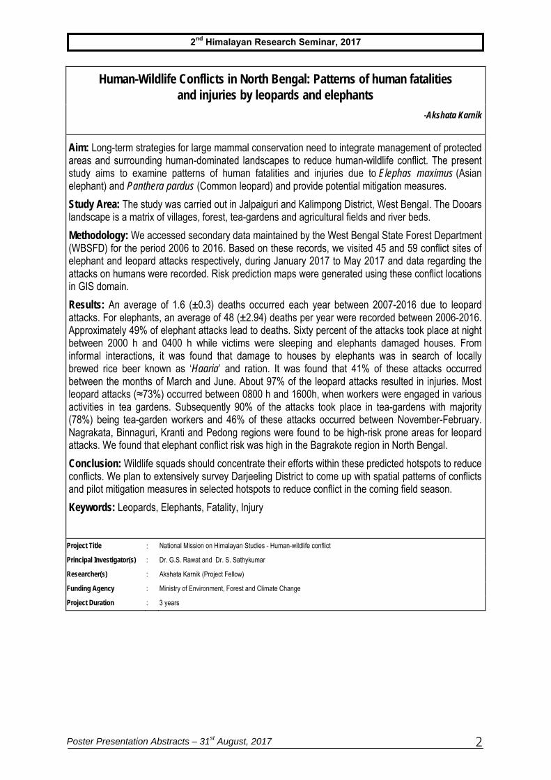
Human-Wildlife Conflicts in North Bengal: Patterns of human fatalities and injuries by leopards and elephants
-Akshata Karnik
Aim: Long-term strategies for large mammal conservation need to integrate management of protected areas and surrounding human-dominated landscapes to reduce human-wildlife conflict. The present study aims to examine patterns of human fatalities and injuries due to Elephas maximus (Asian elephant) and Panthera pardus (Common leopard) and provide potential mitigation measures.
Study Area: The study was carried out in Jalpaiguri and Kalimpong District, West Bengal. The Dooars landscape is a matrix of villages, forest, tea-gardens and agricultural fields and river beds.
Methodology: We accessed secondary data maintained by the West Bengal State Forest Department (WBSFD) for the period 2006 to 2016. Based on these records, we visited 45 and 59 conflict sites of elephant and leopard attacks respectively, during January 2017 to May 2017 and data regarding the attacks on humans were recorded. Risk prediction maps were generated using these conflict locations in GIS domain.
Results: An average of 1.6 (±0.3) deaths occurred each year between 2007-2016 due to leopard attacks. For elephants, an average of 48 (±2.94) deaths per year were recorded between 2006-2016. Approximately 49% of elephant attacks lead to deaths. Sixty percent of the attacks took place at night between 2000 h and 0400 h while victims were sleeping and elephants damaged houses. From informal interactions, it was found that damage to houses by elephants was in search of locally brewed rice beer known as ‘Haaria’ and ration. It was found that 41% of these attacks occurred between the months of March and June. About 97% of the leopard attacks resulted in injuries. Most leopard attacks (≈73%) occurred between 0800 h and 1600h, when workers were engaged in various activities in tea gardens. Subsequently 90% of the attacks took place in tea-gardens with majority (78%) being tea-garden workers and 46% of these attacks occurred between November-February. Nagrakata, Binnaguri, Kranti and Pedong regions were found to be high-risk prone areas for leopard attacks. We found that elephant conflict risk was high in the Bagrakote region in North Bengal.
Conclusion: Wildlife squads should concentrate their efforts within these predicted hotspots to reduce conflicts. We plan to extensively survey Darjeeling District to come up with spatial patterns of conflicts and pilot mitigation measures in selected hotspots to reduce conflict in the coming field season.
Keywords: Leopards, Elephants, Fatality, Injury
Project Title : National Mission on Himalayan Studies - Human-wildlife conflict
Principal Investigator(s) : Dr. G.S. Rawat and Dr. S. Sathykumar
Researcher(s) : Akshata Karnik (Project Fellow)
Funding Agency : Ministry of Environment, Forest and Climate Change
Project Duration : 3 years
2nd Himalayan Research Seminar, 2017
Poster Presentation Abstracts – 31st August, 2017 3
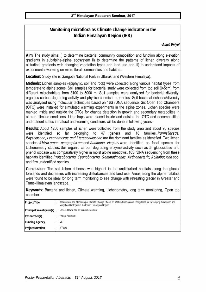
Monitoring microflora as Climate change indicator in the Indian Himalayan Region (IHR)
-Anjali Uniyal
Aim: The study aims: i) to determine bacterial community composition and function along elevation gradients in subalpine-alpine ecosystem ii) to determine the patterns of lichen diversity along altitudinal gradients with changing vegetation types and land use and iii) to understand impacts of experimental warming on micro floral communities and habitats.
Location: Study site is Gangotri National Park in Uttarakhand (Western Himalaya).
Methods: Lichen samples (epiphytic, soil and rock) were collected along various habitat types from temperate to alpine zones. Soil samples for bacterial study were collected from top soil (0-5cm) from different microhabitats from 3100 to 5000 m. Soil samples were analyzed for bacterial diversity, organics carbon degrading activity and physico-chemical properties. Soil bacterial richness/diversity was analysed using molecular techniques based on 16S rDNA sequence. Six Open Top Chambers (OTC) were installed for simulated warming experiments in the alpine zones. Lichen species were marked inside and outside the OTCs for change detection in growth and secondary metabolites in altered climatic conditions. Litter traps were placed inside and outside the OTC and decomposition and nutrient status in natural and warming conditions will be done in following years.
Results: About 1200 samples of lichen were collected from the study area and about 90 species were identified so far belonging to 47 genera and 18 families. Parmeliaceae, Physciaceae, Lecanoraceae and Stereocaulaceae are the dominant families as identified. Two lichen species, Rhizocarpon geographicum and Xanthoria elegans were identified as focal species for Lichenometry studies. Soil organic carbon degrading enzyme activity such as â- glucosidase and phenol oxidase was comparatively higher in moist alpine meadows. 16S rDNA sequencing from these habitats identified Proteobacteria, Cyanobacteria, Gemmatimonas, Actinobacteria, Acidobacteria spp. and few unidentified species.
Conclusion: The soil lichen richness was highest in the undisturbed habitats along the glacier forelands and decreases with increasing disturbances and land use. Areas along the alpine habitats were found to be ideal for long term monitoring to see change with retreating glacier in Greater and Trans-Himalayan landscape.
Keywords: Bacteria and lichen, Climate warming, Lichenometry, long term monitoring, Open top chamber.
Project Title : Assessment and Monitoring of Climate Change Effects on Wildlife Species and Ecosystems for Developing Adaptation and Mitigation Strategies in the Indian Himalayan Region
Principal Investigator(s) : Dr G.S. Rawat and Dr Gautam Talukdar
Researcher(s) : Project Assistant
Funding Agency : DST
Project Duration : 3 Years
2nd Himalayan Research Seminar, 2017
Poster Presentation Abstracts – 31st August, 2017 4
Identification of macro-invertebrates for assessment of water quality in Kedarnath Wildlife Sanctuary
-Anjani Rawat
Aim: To use aquatic macro-invertebrates as a bioindicator for the assessment of water quality in Kedarnath Wildlife Sanctuary.
Study area: The preliminary study have been conducted in the streams and rivers of Kedarnath Wildlife Sanctuary (300 45’ 00” N 790 36’ 00 E) (viz. Son Ganga, Madhmasheswar Ganga, Aakashgamini and Amrit Ganga) located in the Chamoli district of Uttarakhand.
Methodology: Macro-invertebrates were sampled using “Kick” and Hand picking method with a 1×1m square 500µ mesh net. Samples collected from surface of littoral zone , pools, riffles and rapids, logs, litter, boulders and cobbles of stream and river bank upto 100m stretch (Barbour et al. (1999). The jabs or kicks collected from different habitats were composited to obtain a single homogeneous sample and preserved in 70% ethanol. Identification of macro-invertebrates was done using K.A.Subramaniam and K.G.Sivaramakrishnan (ATREE).
Result: Total of 1185 macro-invertebrates collected from four streams and rivers of Kedarnath Wildlife Sanctuary, which were identified upto family levels. 23 families identified, of these, Limnephilidae, Leptoceridae, Lepidostomatidae and Brachycentridae belongs to order Trichoptera and Ephemerellidae belongs to order Ephemeroptera were dominant. Shanon Wiener Index (H), Simpson’s Index (D) and species evenness was found to be 2.21, 0.166 and 0.312 with the Effective Number of Species (ENS) value of 9.1
Conclusion: Kedarnath Wildlife Sanctuary reported with rich diversity of aquatic macroinvertebrates that can be used as bioindicator of water quality.
Keywords: Bioindicator, Environmental variables. Littoral zone, Kedarnath Wildlife Sanctuary.
Project Title : Awareness and capacity building for monitoring the health of environment
Principal Investigator(s) : Dr. V.P Uniyal and Dr. S. Sathyakumar
Researcher(s) : Anjani Rawat
Funding Agency : Ministry of Environment, Forest and Climate Change
Project Duration : 3 years
2nd Himalayan Research Seminar, 2017
Poster Presentation Abstracts – 31st August, 2017 5
People’s perception towards mammals in human dominated landscape of Dooars, North Bengal
-Chandra Maya Sharma
Aim: Information about local people’s knowledge, attitude and perceptions towards wildlife is important in mitigating negative human wildlife interactions. This study aims to understand and acknowledge the factors which will help in site specific solutions to human - wildlife conflict through community participation.
Study area: Dooars region of North Bengal in the foothills of the Eastern Himalaya has rich wildlife diversity although in a matrix of protected areas interspersed with human habitations, tea-estates and agricultural lands.
Methodology: We assessed socio- economic conditions and perception of local communities (N = 186) towards large mammals across 23 fringe villages of Gorumara National Park and Chapramari Wildlife Sanctuary from January to May, 2017 using stratified random sampling approach and semi-structured questionnaire surveys. Majority of the analysis was done using Microsoft excel and R.
Results: The average number of people per household was found to be 5.33 (SE 0.14) and majority of them (47%) were tea estate workers (X² = 83.24, df = 5, p value > 0.05). Twenty-seven percent of the respondents were illiterate with only 3% being graduates. The average landholding size was estimated to be 0.26 hectare (SE 0.03)). Only 24% of the respondents were aware of wild animals’ role in maintaining ecological balance while 49% of the respondents were unaware of these facts. Despite the number of human deaths due to elephant attacks, people had positive attitude towards elephants when compared to leopard and other wildlife. Majority (52%) of people believed that lack of food resources in the forest is the primary cause for wild animals straying into villages, leading to an increase in human-wildlife conflict. Non-lethal measures such as electric fencing, intensive patrolling at night and effective compensation policies were suggested by local people as potential measures to reduce human-elephant conflict. In case of livestock depredation and attacks on humans by leopards, local communities suggested constructing predator-proof livestock enclosures and developing early warning systems as plausible solutions to reduce conflicts.
Conclusion: This are preliminary findings and we propose to extensively survey high altitude areas of North Bengal for understanding perceptions of people towards large mammals and pilot mitigation measures in selected hotspots in the coming field season. Wildlife awareness programmes need to be conducted in the region to increase people’s tolerance towards large mammals.
Keywords: Knowledge, local people, conflict, elephant, leopard.
Project Title : National Mission on Himalayan Studies- Human Wildlife Conflict
Principal Investigator(s) : Dr. G.S. Rawat and Dr. S. Sathyakumar
Researcher(s) : Chandra Maya Sharma (Project Fellow)
Funding Agency : Ministry of Environment, Forest and Climate Change
Project Duration : 3 Year
2nd Himalayan Research Seminar, 2017
Poster Presentation Abstracts – 31st August, 2017 6
TIME-LEARN: An uplift for Mountain Ecosystems
- Charuhas Dali
Aim: Technology Intervention for Mountain Ecosystem (TIME) programme aims to develop an innovative mechanism for sustainable development in the mountain regions with the help of science and technology based field groups, voluntary organizations and institutions.
Location: Total 19 projects are being implemented by various organizations and scientific institutions in the three Western Himalayan states of Uttarakhand (7), Himachal Pradesh (8) and Jammu and Kashmir (4).
Methods: Indicators were identified for the thrust areas. Based on these indicators the projects are being evaluated, monitored and gaps are being identified. Besides these, field visits will be undertaken and workshops will be organized to monitor the projects’ progress.
Results: There are 7 thrust areas of the TIME-LEARN programme and according to them, 7 projects are under the category of Sustainable Agriculture whereas 5 projects each are under Forest use & Conservation and Rural Engineering & Technology and a single project each under the category of Water Resource Management and Disaster Management. There are no projects under the category of Gender Sensitive Development and Harnessing and Conserving Renewable Energy. Thirteen projects have completed duration of one year and remaining ones are just over six months.
Conclusion: A Planning and Execution Workshop conducted at Wildlife Institute of India concluded that programme should expand and focus should be given on specific problems like water resource management, gender development and agro-forestry. The programme is helping to build a bridge between the traditional knowledge and skill of mountain community with modern technologies that will help in bringing sustainability to the economy as well as the ecology of the region.
Keywords: Western Himalayas, technology intervention, sustainability, networking, community participation
Project Title : Dissemination and evaluation of technologies through networking of various institutes and organizations of mountain ecosystem of Western Himalayas
Principal Investigator(s) : Dr. Ruchi Badola and Dr. S.A. Hussain
Researcher(s) : Mr. Charuhas Dali (Junior Research Fellow)
Funding Agency : Department of Science and Technology, Govt. of India
Project Duration : 2017 - 2020
2nd Himalayan Research Seminar, 2017
Poster Presentation Abstracts – 31st August, 2017 7
Assessment of traditional knowledge related to healthcare system among Barpatiya and Raji communities in Eastern Uttarakhand
-Pradeep Kumar and Naveen Chandra Joshi
Aim: The aim of this study was to assess the status of traditional knowledge pertaining to healthcare system using herbal medicines among Barpatiya and Raji communities in Pithoragarh District, Uttarakhand. Barpatiyas represent the agro-pastoralists and most ancient settlers while Rajis are among the most primitive vulnerable tribes of India who have been leading the life of hunter-gatherers till a few decades ago.
Study Area: The study was conducted in Eastern part of Uttarakhand covering four Blocks of Pithoragarh district. Two indigenous ethnic communities selected for the study were Barpatiya(s) and Raji(s) or Van-Rajis.
Methods: The method of purposive snowball sampling was adopted for collection of data by asking a participant to suggest someone else who might be knowledgeable and willing or appropriate for the study. The data on traditional healthcare were collected through semi-structured questionnaires, focused group discussions using check lists, field observations and transact walks. We interviewed a total of 66 respondents in 11 villages covering three age groups (below 30, 30 – 50, 51 and above) from both genders. The voucher specimens were collected with the help of local people to identify the plants correctly. Local names as well as uses for each collected species were recorded on the spot.
Results: Barpatiyas and Rajis used 33 and 61 species of plants for the local health care respectively. In both the communities males in middle age group possessed more knowledge on the use of medicinal plants. Various categories of ailments including veterinary care and number of species used for the treatment have been compared for both the communities. The gastro-intestinal problems was reported to be the most common disease in both the communities. Barpatiyas used 70% herbs mostly in crushed form (51%) and roots (51.85%). However, Rajis used 36.07% of herbs either in raw form or decoction of leaves and use of animal parts (at least 10 species) as medicine was also recorded in Rajis.
Conclusion: Despite globalization and rapid socio-economic transformation both Barpatiyas and Rajis retain a considerable knowledge on the use of wild medicinal plants and animals. In both the communities middle age group had higher knowledge about the medicinal plants.
Keywords: Indigenous, Herbal Medicines, Agro-Pastoralist, Primitive Vulnerable Tribe
Project Title : Documentation of Traditional Ecological Knowledge among Indigenous Ethnic Communities of Pithoragarh District, Uttarakhand
Principal Investigator(s) : Dr. G.S. Rawat
Researcher(s) : Pradeep Kumar (Project Fellow) and Dr. Naveen Chandra Joshi (Project Associate)
Funding Agency : Department of Science and Technology, Govt. of India
Project Duration : 2015-2019
2nd Himalayan Research Seminar, 2017
Poster Presentation Abstracts – 31st August, 2017 8
Assessment of soil nematode among different habitats of Gangotri National Park, Uttarakhand
-Priyanka Kashyap
Aim: The aim of the present study is to create baseline data of soil nematodes diversity along altitudinal gradient in Gangotri National Park, Uttarakhand and to study the effect of changes in temperature and humidity on nematode communities through an experimental setup which may prove beneficial in understanding the possible impacts of climate change.
Study Area: The study was conducted in Gangotri and Nilong Valley of Gangotri National Park. (3000 – 5000 m).
Methods: Nematodes were examined from 52 soil samples from Gangotri valley and Nelang valley of along elevation gradient Gangotri National Park (3000m – 5000m) covering subalpine and alpine region of Gangotri valley. The proposed methodology includes installation of Open Top Chambers (OTCs, n=6), soil sampling, nematode extraction, processing and identification, soil physiochemical analysis to achieve the objectives. Two time sampling were carried out from OTCs and each control site in the month of October & May. Soil analysis for various physiochemical parameters was performed to find its correlation with the changing soil parameters.
Results: The study revealed that seven major orders are present in these areas namely, Dorylaimida, Rhabditida, Chromadorida, Araeolaimida, Tylenchida, and Mononchida. These orders belong to 5 trophic groups i.e. Bacterivores, Fungivorous, Plant-parasitic, Predators and Omnivores. The suborder Cephalobina has been identified and segregated upto five genera. Further, two and three genera under Araeolaimida, Aphelenchida have been identified, respectively. Order Dorylaimida, Tylenchida are commonly distributed along elevation gradient in the study area. The detailed identification is in progress.
Keywords: Climate change, Elevation gradient, Open top chamber, Trophic group, Cephalobina
Project Title : Assessment and monitoring of climate change effects on wildlife species and ecosystems for developing adaptation and mitigation strategies in the Indian Himalayan Region
Principal Investigator(s) : Dr. V.P Uniyal, (Principal Investigator), Dr. Anjum Rizvi (ZSI,Kolkata) (Co-Investigator)
Researcher(s) : Priyanka kashyap (Himalayan Junior Research fellow)
Funding Agency : National Mission on Himalayan Studies
Project Duration : 2016 - 2019
2nd Himalayan Research Seminar, 2017
Poster Presentation Abstracts – 31st August, 2017 9
Assessment of mammal-habitat interactions in Beas catchment, Himachal Pradesh: Steps towards sustainable natural resource management
- Shagun Thakur
The study aims to assess the mammal-habitat interactions in relation to anthropogenic pressures such as livestock grazing, Non Timber Forest Produce (NTFP) collection in Great Himalayan National Park Conservation Area (GHNPCA) Himachal Pradesh and to develop a protocol for the sustainable use of natural resources. The park is well recognized for its unique biodiversity assemblages and is home to four globally threatened mammals (Snow leopard, Himalayan serow, Himalayan tahr, Musk deer). It has also been inscribed as UNESCO Natural World Heritage site for its outstanding universal value. However, the park still experiences anthropogenic pressures in the form of livestock grazing and medicinal plant collection.
To assess the distribution and abundance of the large mammals, camera traps (n= 73) were deployed systematically during March to June 2017, following 2x2 km grids. Camera traps were deployed in five different habitats such as open scrub forest, temperate broadleaved forest, temperate conifer-broadleaved mixed forest, sub-alpine forest and Rhododendron scrub and alpine meadow. Preliminary analysis of relative encounter rates (# photo captures + SE/100 days) was carried out.
Preliminary analysis revealed that 17 mammalian species have been photo-captured in Tirthan valley. Rhesus macaque was photo-captured most frequently (16.91±7.11/100 days) followed by Indian crested porcupine and Red fox. Among the threatened mammals, Himalayan brown bear (1.14±0.55 /100 days), Asiatic black bear (2.01±0.95/100 days) Himalayan musk deer (0.11±0.07 /100 days), Himalayan tahr (0.13±0.11 /100 days), Himalayan goral (1.74±0.65 /100 days) and Himalayan serow ( 0.14±0.10 /100 days) were recorded. Among these threatened mammals, six species were recorded from temperate conifer and broadleaved mixed forests. Simultaneously, high degrees of anthropogenic activities such as livestock grazing, medicinal plant collection (human 481.66± 247.49/ 100 days, livestock 53.33± 3.67/100 days) have also been recorded.
It will be important to understand the intensity of use by the mammal and the relative abundance in the specific habitats, in response to livestock grazing and medicinal plant collection. With the knowledge, a protocol for sustainable management of the area is likely to be developed.
Keywords: Great Himalayan National Park, livestock grazing, medicinal plant collection, Camera Trapping, Threatened mammals
Project Title : Assessment and monitoring of climate change effects on wildlife species and ecosystems for developing adaptation and mitigation in the Indian Himalayan Region
Principal Investigator(s) : Dr. S.Sathyakumar (Principal Investigator) and Dr. Ramesh Krishnamurthy (Co-Investigator)
Researcher(s) : Shagun Thakur, Himalayan (Junior Research Fellow)
Funding Agency : National Mission on Himalayan Studies
Project Duration : 15th Sep 2016-15th Sep 2019
2nd Himalayan Research Seminar, 2017
Poster Presentation Abstracts – 31st August, 2017 10
Structure and composition of forest communities in Askot landscape, Uttarakhand
-Soni Bisht
Aim: To understand the patterns of diversity and regeneration status of dominant tree species in different forest types
Location: The study was conducted in Gori and Dhauli watersheds (ca. 1172 km2) of Askot landscape, Pithoragarh, Uttarakhand with an elevation range between 1100 to 3900m asl.
Methods: The study sites were selected based on reconnaissance survey followed by stratification on the basis of major forest types and elevation gradient. In each site (ca.1 ha), 3 circular plots (10 m radius each) were laid within each hectare plot to assess vegetation structure and composition. Parameters such as GPS location, total number of species and circumference at breast height (cbh at 1.37 m) were recorded for all the trees. TWINSPAN was used to identify forest communities.
Results: Twelve forest communities were identified. The tree density was highest for Mixed broadleaved forest (375 tree ha-¹) followed by Rianj oak forest (336 tree ha-¹), while lowest for Birch forest (155 tree ha-¹) and Fir forest (142 tree ha-¹). The mixed broadleaved forest had the highest species richness and diversity (28 and 2.60 respectively) whereas Blue pine forest had the lowest (2 and 0.058 respectively).
Birch forest supports regeneration of Fir (382 indi ha-1) under its canopy whereas, Fir forest supports Birch individuals (1401 indi ha-1). Among oaks, Moru oak forest lack regeneration and Banj oak and Kharsu oak forests had good regeneration. Rianj oak indicated that the forest was old growth and supports the regeneration of Banj oak under its canopy. Hemlock forest in the study area supported old mature trees and the regeneration of Kharsu oak. This indicates that Hemlock forests will be replaced by Kharsu oak forest in near future.
Conclusion: Lopping in Q. floribunda forest is detrimental to its regeneration, while poor regeneration in T. dumosa is due to its restricted distribution, being an element of East Himalaya. Both the species require timely interventions for their conservation. Frequent monitoring of forest communities is essential to understand the dynamics which will support sustainable management.
Keywords: Askot Landscape, Diversity, Hemlock, Regeneration, Conservation
Project Title : Biodiversity Conservation and Rural Livelihood Improvement Project (BCRLIP)
Principal Investigator(s) : Dr. B.S. Adhikari and Ajay Shrivastav
Researcher(s) : Soni Bisht (Project Assistant)
Funding Agency : World Bank
Project Duration : 2018
2nd Himalayan Research Seminar, 2017
Poster Presentation Abstracts – 31st August, 2017 11
National Mission for Sustaining Himalayan Ecosystem: An overview of Landscape Ecology and Visualization Laboratory
-Tanvi Gaur
Aim: Landscape Ecology and Visualization Laboratory (LEVL) established at Wildlife Institute of India, under the National Mission for Sustaining Himalayan Ecosystem aims to (a) develop spatial and inter-operable database, (b) identify the drivers of landscape change, (c) undertake climate change scenario analyses, (d) visualize potential effects on biodiversity, (e) develop monitoring and decision support system for indicator species and (f) to build capacities of stake holders.
Location: The Indian Himalayan Region with intensive focus in Bhagirathi basin (Uttarakhand), Beas basin (Himachal Pradesh) and Teesta basin (Sikkim).
Methods: We have so far established database of 37 spatial layers broadly categorized as, administrative boundary, topography, climate, disturbance, hydrology, socio-economic and ecology and have also carried out (1) multi-scale analyses of landscape change, (2) climate change scenario analyses, (3) species distribution modelling and (4) quality of life analyses for Uttarakhand.
Results: (1) Landscape productivity was found to be majorly determined by the temperature at multiple scales (16 km, 4km & 1 km grids), while precipitation and anthropogenic factors were primary drivers of the change in landscape productivity. (2) The long term (2080) RCP 85 showed the increase in precipitation up to 25% and highest temperature change of about 5.7 0C. (3) Species distribution model for Brown dipper showed that the human footprint and annual precipitation to have deterministic effect (AUC = 0.81) on the species occurrence. (4) The Quality of Life (QOL) index values for the villages in the Bhagirathi basin ranged from 0.18 to 0.89, reflecting poor to high quality of well-being.
Conclusion: Spatially explicit visualization outputs which are in the process will provide a better prospect for mobilizing stakeholders and influencing policy makers and local communities. LEVL will continue to explore new areas of spatial data management and decision support tools, and would strive to establish science-policy interface towards effective adaptation and mitigation strategies to deal with climate change effects in the Indian Himalayan Region.
Keywords: Climate change scenario, Decision support system, Landscape change, Quality of Life, Spatial inter-operable database
Project Title : Assessment and Monitoring of Climate Change Effects on Wildlife Species and Ecosystems for Developing Adaptation and Mitigation Strategies in the Indian Himalayan Region
Principal Investigator(s) : Dr. Ramesh Krishnamurthy, Dr. S. Sathyakumar and Dr. V.B. Mathur
Researcher(s) : Mrs. Sujata Upgupta (Project Scientist); Arun Kumar A. (Project Associate), Tanvi Gaur (Senior Project Fellow) and Veenita Rani Singh (Project Assistant)
Funding Agency : Department of Science and Technology, Government of India
Project Duration : 2015- 2020
Post Box 18, Chandrabani, Dehradun 248 001, Uttarakhand, India EPABX: +91 135 2640114, 2640115, 2646100; Fax: +91 135 2640117
Email: [email protected]; Website: www.wii.gov.in
![[slides] Authenticated Encryption GCM - CCM](https://static.fdocuments.us/doc/165x107/5464a3d0b4af9fda3f8b4717/slides-authenticated-encryption-gcm-ccm.jpg)