LIS No. 101 - Fiji's Maritime Claims (FJ) 1984 · 2019-09-06 · archipelagic straight baselines...
38
Transcript of LIS No. 101 - Fiji's Maritime Claims (FJ) 1984 · 2019-09-06 · archipelagic straight baselines...
2
Introduction
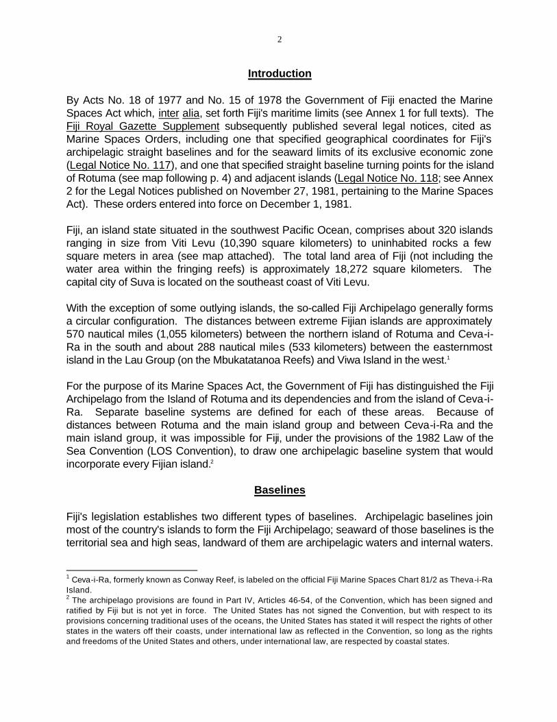
By Acts No. 18 of 1977 and No. 15 of 1978 the Government of Fiji enacted the Marine Spaces Act which, inter alia, set forth Fiji's maritime limits (see Annex 1 for full texts). The Fiji Royal Gazette Supplement subsequently published several legal notices, cited as Marine Spaces Orders, including one that specified geographical coordinates for Fiji's archipelagic straight baselines and for the seaward limits of its exclusive economic zone (Legal Notice No. 117), and one that specified straight baseline turning points for the island of Rotuma (see map following p. 4) and adjacent islands (Legal Notice No. 118; see Annex 2 for the Legal Notices published on November 27, 1981, pertaining to the Marine Spaces Act). These orders entered into force on December 1, 1981.
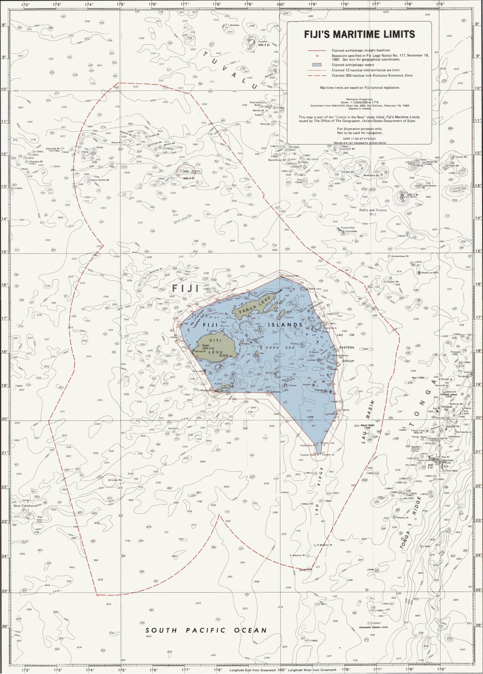
Fiji, an island state situated in the southwest Pacific Ocean, comprises about 320 islands ranging in size from Viti Levu (10,390 square kilometers) to uninhabited rocks a few square meters in area (see map attached). The total land area of Fiji (not including the water area within the fringing reefs) is approximately 18,272 square kilometers. The capital city of Suva is located on the southeast coast of Viti Levu.
With the exception of some outlying islands, the so-called Fiji Archipelago generally forms a circular configuration. The distances between extreme Fijian islands are approximately 570 nautical miles (1,055 kilometers) between the northern island of Rotuma and Ceva-i-Ra in the south and about 288 nautical miles (533 kilometers) between the easternmost island in the Lau Group (on the Mbukatatanoa Reefs) and Viwa Island in the west.1
For the purpose of its Marine Spaces Act, the Government of Fiji has distinguished the Fiji Archipelago from the Island of Rotuma and its dependencies and from the island of Ceva-i-Ra. Separate baseline systems are defined for each of these areas. Because of distances between Rotuma and the main island group and between Ceva-i-Ra and the main island group, it was impossible for Fiji, under the provisions of the 1982 Law of the Sea Convention (LOS Convention), to draw one archipelagic baseline system that would incorporate every Fijian island.2
Baselines
Fiji's legislation establishes two different types of baselines. Archipelagic baselines join most of the country's islands to form the Fiji Archipelago; seaward of those baselines is the territorial sea and high seas, landward of them are archipelagic waters and internal waters.
1 Ceva-i-Ra, formerly known as Conway Reef, is labeled on the official Fiji Marine Spaces Chart 81/2 as Theva-i-Ra Island. 2 The archipelago provisions are found in Part IV, Articles 46-54, of the Convention, which has been signed and ratified by Fiji but is not yet in force. The United States has not signed the Convention, but with respect to its provisions concerning traditional uses of the oceans, the United States has stated it will respect the rights of other states in the waters off their coasts, under international law as reflected in the Convention, so long as the rights and freedoms of the United States and others, under international law, are respected by coastal states.
- 3
The other type of baseline delimits the internal waters from archipelagic waters (if situated inside archipelagic baselines) or from the territorial sea (as in the Rotuma Island area).
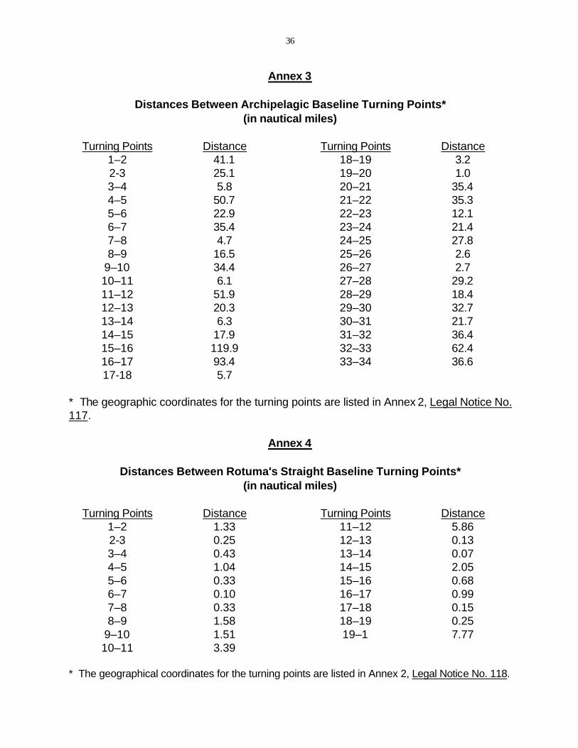
The archipelagic straight baseline system comprises 34 turning points and connects the outer point of the outer islands and drying reefs. Legal Notice 117 (paragraph 2) states that the geographical coordinates of the basepoints are based on the World Geodetic System 1972 (WGS72) and that the listings given in the First Schedule are correct, minus 7 seconds of latitude and 14 seconds of longitude in each case. The distance between basepoints ranges from 1.0 nautical miles (between points 19 and 20) to 119.9 nautical miles (between points 15 and 16), with a mean length of 27.7 nautical miles (see Annex 3 for a listing of the distances between the archipelagic turning points). The baseline length criterion cited in Article 47(2) of the LOS Convention is met. This paragraph states:
"The length of such baselines shall not exceed 100 nautical miles, except that up to 3 percent of the total number of baselines enclosing any archipelago may exceed that length, up to a maximum length of 125 nautical miles."
These baselines, along with the depiction of the internal waters and the territorial sea limit, are officially illustrated on Fiji Marine Spaces Chart 81/2 which is based on British Admiralty Chart 2691, 1970. The attached chart (which does not show the internal waters) is based on US DMAHTC chart 605 and is produced solely for the purpose of this study.
According to Article 47(1) of the LOS Convention:
"An archipelagic State may draw straight archipelagic baselines joining the outermost points of the outermost islands and drying reefs of the archipelago provided that within such baselines are included the main islands and an area in which the ratio of the area of the water to the area of the land, including atolls, is between 1 to 1 and 9 to 1."
It would appear that Fiji's archipelagic baseline system meets these requirements. As shown on Fiji's Marine Spaces Chart 81/2, 30 of the 34 baseline turning points seem to be located on drying reefs and only 4 turning points (Nos. 1, 8, 26, and 33) fall on land. The total area enclosed by the archipelagic baselines is approximately 174,300 square kilometers (50,900 sq. nautical miles). Based on Fiji's internal waters claim this area includes the following components3:
Land = 18,272 sq. kilometers Internal waters = 25,558 sq. kilometers Archipelagic waters = 130,470 sq. kilometers
3 The land area is taken from the Pacific Islands Yearbook, Thirteenth Edition, Sydney, 1978, p. 89. Measurements for the internal and archipelagic waters were made on Fiji Marine Spaces Chart 81/2.
- 4
For the purpose of calculating the water-to-land area ratio, Article 47(7) allows the use of "waters lying within the fringing reefs of islands and atolls…." In Fiji's case these waters, claimed as internal waters, are about 1.4 times the total land area. The resulting water-area-to-land-area ratio is well within the LOS Convention range:
130,470: 43,830 = 2.98: 1.
It is with respect to fringing reefs that most of the questions regarding the internal baselines arise. Article 6 of the LOS Convention provides:
"In the case of islands situated on atolls or of islands having fringing reefs, the baseline for measuring the breadth of the territorial sea is the seaward low-water line of the reef, as shown by the appropriate symbol on charts officially recognized by the coastal State."
A fundamental omission from the LOS Convention is a provision designating appropriate reef closing lines similar to the provisions given for "rivers" and "bays" found in Articles 9 and 10, respectively. Many of the reefs surrounding Fijian islands extend from the land and are unbroken physical features. Other reefs, however, contain one or several entrances to the lagoons that they surround. Fiji arbitrarily has drawn closing lines for these reef entrances. Depending on one's interpretation of the LOS text, it may be questionable whether Fiji can legally claim much of the enclosed waters as internal. An examination of the Fijian chart shows at least four areas where Fiji's claimed internal water baseline may be somewhat far reaching.
The first area is at the Heemskercq Reefs (not labeled on the attached map), located near the northeast corner of the archipelago, east of Vanua Levu. Although there may be a problem of chart symbol interpretation, the baseline appears to follow along a symbol depicting a submerged feature for about 13 nautical miles.
Off the west coast of Vanua Levu an internal water baseline has been drawn along the Pascoe Reefs (to the southwest of the Great Sea Reef). Across Round Island Passage, to the east of Yasawa Group, internal water baselines have been drawn along an area labeled Tivolei on the Fiji chart. In both areas the chart symbols indicate submerged features rather than drying reefs. And finally, south of Viti Levu the small island of Mbengga contains two internal water baselines that do not appear to follow along drying reefs. To conform to the LOS Convention it would appear that some adjustments to the internal water baseline should be made, adjustments that would not affect significantly the archipelagic water to land area ratio.
The baseline for Ceva-i-Ra is the low-water line of the drying reefs that surround the island. The island itself measures only about 100 meters by 325 meters, and the internal waters enclosed by the claimed baselines are approximately 2.5 sq. kilometers.
- 5
The baseline claimed by Fiji for its northern island of Rotuma may be questionable. In the Marine Spaces Act Rotuma is defined as the "Rotuma archipelago" comprising Rotuma and its dependencies, which include about six smaller islands situated between 1.5 and 4.5 nautical miles to the west of Rotuma. Currently before Fiji's Parliament is an amendment to the Marine Spaces Act which, inter alia, deletes reference to Rotuma as an archipelago. Instead, the waters within the baselines are intended to be internal waters and not archipelagic waters. The baselines are shown on Fiji Marine Spaces Chart 81/1 titled, "Chart Showing Basepoints and Straight Baselines Enclosing the Internal Waters of Rotuma." An unofficial sketch of this map is provided in this study (following this page) for illustrative purposes only.
The legal-geographical basis on which Fiji claims much of these waters as internal highlights an interpretative problem posed by terms of the LOS Convention text. There is a reef system immediately off the island of Rotuma and essentially attached to the island. Distinct from and separated by waters with depths of greater than 20 fathoms (120 feet) are the several smaller islands situated to Rotuma's west. According to Article 7(1) of the LOS Convention text, a state may draw straight baselines, "In localities where the coastline is deeply indented and cut into, or if there is a fringe of islands along the coast in its immediate vicinity…." No definition is given for a "fringe of islands." Although the distances involved in this claimed straight baseline system are modest in global terms (see Annex 4 for a listing of distances between turning points), it is questionable whether the small islands situated to the west of Rotuma constitute a "fringe of islands."
Territorial Sea
Under the LOS Convention a country may claim a 12-nautical-mile territorial sea, measured from baselines determined in accordance with the Convention. Fiji claims that its territorial sea extends from the low-water line of Ceva-i-Ra, from the archipelagic baselines of the Fiji archipelago, and from the straight baselines of Rotuma Islands and its dependencies.
The approximate area encompassed by Fiji's claimed territorial sea is the following:
Fiji archipelago = 40,000 sq. km (11,685 sq.nm) Rotuma = 3,225 sq. km ( 940 sq.nm) Cevai-Ra = 2,150 sq. km ( 625 sq.nm)
TOTAL = 45,375 sq. km (13,250 sq.nm)
Exclusive Economic Zone
Section 6 of the Marine Spaces Act defines the exclusive economic zone as extending 200 nautical miles from the baseline from which the territorial sea is measured (paragraph 1). In areas where neighboring states are situated less than 400 nautical miles from Fijian baselines, the economic zone shall extend to the median line (paragraph 3). Within the economic zone, Fiji claims sovereign rights "for the purpose of exploring and exploiting,
- 6
conserving and managing the natural resources, whether living or non-living of the seabed and subsoil and the superjacent waters" (Section 9, para. 2). Section 11 authorizes the Foreign Affairs Minister to make regulations for the economic zone, in accordance with the rules of international law, for purposes related to:
-- the conduct of scientific research; -- the exploration and exploitation of the EEZ for the production of energy from the waters, currents, and winds, and for other economic purposes;-- the construction, operation, and use of artificial islands, installations, and structures including, but not confined to, the establishment of safety zones around islands, installations and structures; -- prescribing measures for the protection and preservation of the marine environment of the EEZ.
The area between the limits of Fiji's territorial sea and of its economic zone is approximately 1,145,000 sq. km (334,000 sq. nm) or about 6.6 times the area enclosed within the archipelagic baselines.4
Maritime Boundaries
In claiming its economic zone, Fiji is able to extend fully to 200 nautical miles only to the south and to the northwest. Similar or potential claims to extended maritime jurisdiction by its neighbors will create six maritime boundary situations for Fiji. Boundaries will be required with Tonga to the east and southeast, Tuvalu to the north, the Solomon Islands west of Rotuma, Vanuatu to the west, and France to the northeast (Wallis and Futuna) and southwest (New Caledonia).
In 1983 Fiji and France signed an agreement delimiting the boundary between the economic zones claimed by the two states. The line between Fiji and New Caledonia is an apparent equidistant line, about 300 nautical miles in length, using as controlling basepoints Ceva-i-Ra for Fiji and Hunter Island for France. A sovereignty claim to Hunter Island has been made by Vanuatu and it is unclear what impact this dispute may have on the Fiji-France agreement. The other four boundaries remain to be negotiated.
Tonga's claim to the Minerva Reefs, situated south of Fiji's archipelago, may complicate Tongan-Fijian maritime boundary negotiations. Although Fiji acknowledges Tonga's claim to these reefs (as noted on its Chart 81/3), Fiji's economic zone limits enclose the reefs. North and South Minerva Reef are about 18 nautical miles apart and more than 165 nautical miles from the nearest Tongan island. The Tongan Government has built an artificial island and installed navigation beacons on each. If indeed the reefs themselves
4 The area of the exclusive economic zone was measured from Fiji Marine Spaces Chart 81/3.

- 7
are only low-tide elevations, they would not have a territorial sea (LOS Convention, Article 13(2)). Tonga's rights, under the LOS Convention, to construct, operate, and use an artificial island, such as North or South Minerva Reef, within its economic zone, may be complicated by the fact that these reefs, under Fiji's claims, are situated in the Fiji EEZ.

8
ANNEX 1
LAWS OF FIJI
Chapter 158A
MARINE SPACES
__________________________________________________________
_______
- 9
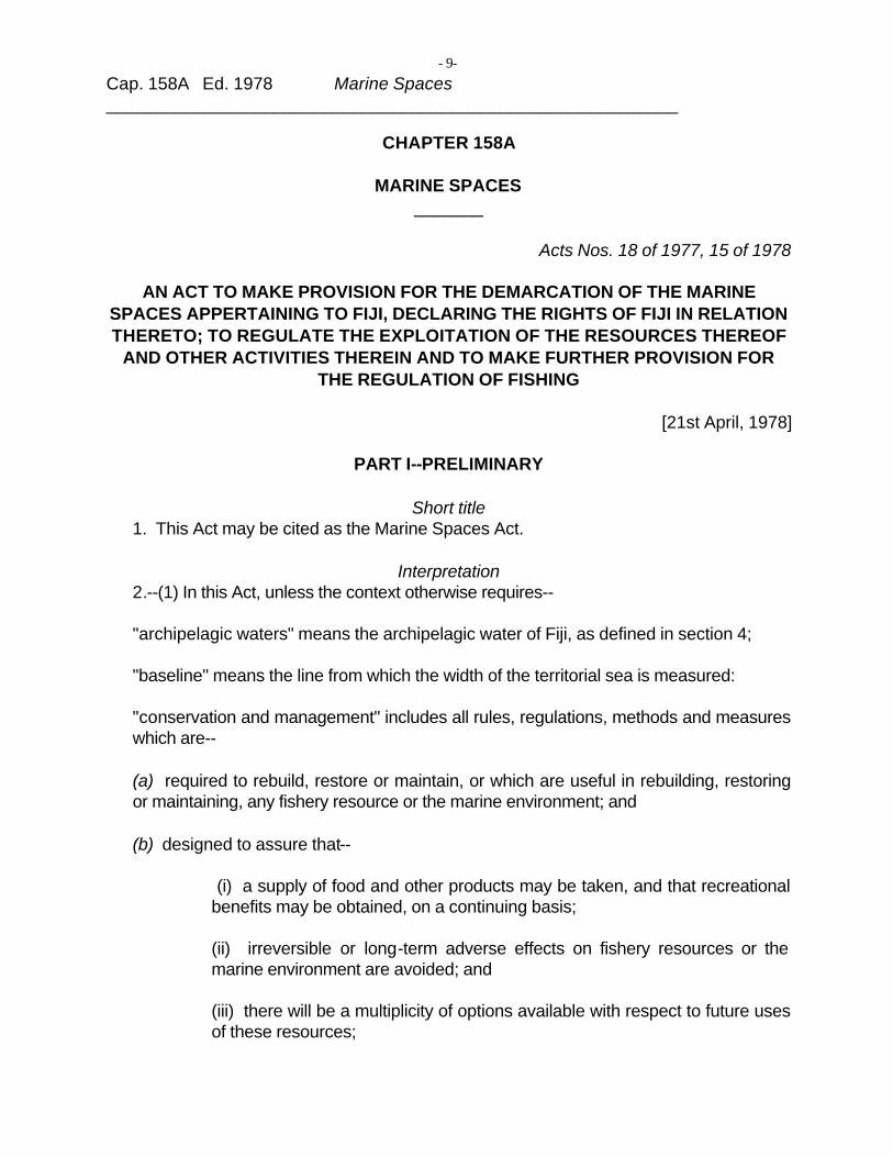
Cap. 158A Ed. 1978 Marine Spaces
CHAPTER 158A
MARINE SPACES
Acts Nos. 18 of 1977, 15 of 1978
AN ACT TO MAKE PROVISION FOR THE DEMARCATION OF THE MARINE SPACES APPERTAINING TO FIJI, DECLARING THE RIGHTS OF FIJI IN RELATION THERETO; TO REGULATE THE EXPLOITATION OF THE RESOURCES THEREOF
AND OTHER ACTIVITIES THEREIN AND TO MAKE FURTHER PROVISION FOR THE REGULATION OF FISHING
[21st April, 1978]
PART I--PRELIMINARY
Short title 1. This Act may be cited as the Marine Spaces Act.
Interpretation 2.--(1) In this Act, unless the context otherwise requires--
"archipelagic waters" means the archipelagic water of Fiji, as defined in section 4;
"baseline" means the line from which the width of the territorial sea is measured:
"conservation and management" includes all rules, regulations, methods and measures which are--
(a) required to rebuild, restore or maintain, or which are useful in rebuilding, restoring or maintaining, any fishery resource or the marine environment; and
(b) designed to assure that--
(i) a supply of food and other products may be taken, and that recreational benefits may be obtained, on a continuing basis;
(ii) irreversible or long-term adverse effects on fishery resources or the marine environment are avoided; and
(iii) there will be a multiplicity of options available with respect to future uses of these resources;
- 10 -
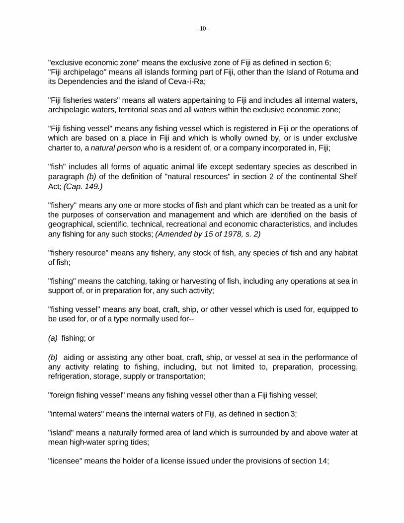
"exclusive economic zone" means the exclusive zone of Fiji as defined in section 6; "Fiji archipelago" means all islands forming part of Fiji, other than the Island of Rotuma and its Dependencies and the island of Ceva-i-Ra;
"Fiji fisheries waters" means all waters appertaining to Fiji and includes all internal waters, archipelagic waters, territorial seas and all waters within the exclusive economic zone;
"Fiji fishing vessel" means any fishing vessel which is registered in Fiji or the operations of which are based on a place in Fiji and which is wholly owned by, or is under exclusive charter to, a natural person who is a resident of, or a company incorporated in, Fiji;
"fish" includes all forms of aquatic animal life except sedentary species as described in paragraph (b) of the definition of "natural resources" in section 2 of the continental Shelf Act; (Cap. 149.)
"fishery" means any one or more stocks of fish and plant which can be treated as a unit for the purposes of conservation and management and which are identified on the basis of geographical, scientific, technical, recreational and economic characteristics, and includes any fishing for any such stocks; (Amended by 15 of 1978, s. 2)
"fishery resource" means any fishery, any stock of fish, any species of fish and any habitat of fish;
"fishing" means the catching, taking or harvesting of fish, including any operations at sea in support of, or in preparation for, any such activity;
"fishing vessel" means any boat, craft, ship, or other vessel which is used for, equipped to be used for, or of a type normally used for--
(a) fishing; or
(b) aiding or assisting any other boat, craft, ship, or vessel at sea in the performance of any activity relating to fishing, including, but not limited to, preparation, processing, refrigeration, storage, supply or transportation;
"foreign fishing vessel" means any fishing vessel other than a Fiji fishing vessel;
"internal waters" means the internal waters of Fiji, as defined in section 3;
"island" means a naturally formed area of land which is surrounded by and above water at mean high-water spring tides;
"licensee" means the holder of a license issued under the provisions of section 14;
- 11 -
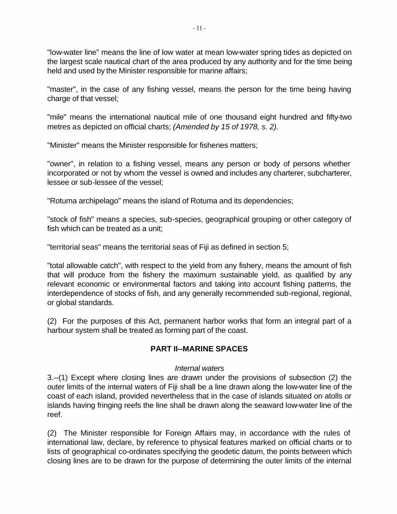
"low-water line" means the line of low water at mean low-water spring tides as depicted on the largest scale nautical chart of the area produced by any authority and for the time being held and used by the Minister responsible for marine affairs;
"master", in the case of any fishing vessel, means the person for the time being having charge of that vessel;
"mile" means the international nautical mile of one thousand eight hundred and fifty-two metres as depicted on official charts; (Amended by 15 of 1978, s. 2).
"Minister" means the Minister responsible for fisheries matters;
"owner", in relation to a fishing vessel, means any person or body of persons whether incorporated or not by whom the vessel is owned and includes any charterer, subcharterer, lessee or sub-lessee of the vessel;
"Rotuma archipelago" means the island of Rotuma and its dependencies;
"stock of fish" means a species, sub-species, geographical grouping or other category of fish which can be treated as a unit;
"territorial seas" means the territorial seas of Fiji as defined in section 5;
"total allowable catch", with respect to the yield from any fishery, means the amount of fish that will produce from the fishery the maximum sustainable yield, as qualified by any relevant economic or environmental factors and taking into account fishing patterns, the interdependence of stocks of fish, and any generally recommended sub-regional, regional, or global standards.
(2) For the purposes of this Act, permanent harbor works that form an integral part of a harbour system shall be treated as forming part of the coast.
PART II--MARINE SPACES
Internal waters 3.--(1) Except where closing lines are drawn under the provisions of subsection (2) the outer limits of the internal waters of Fiji shall be a line drawn along the low-water line of the coast of each island, provided nevertheless that in the case of islands situated on atolls or islands having fringing reefs the line shall be drawn along the seaward low-water line of the reef.
(2) The Minister responsible for Foreign Affairs may, in accordance with the rules of international law, declare, by reference to physical features marked on official charts or to lists of geographical co-ordinates specifying the geodetic datum, the points between which closing lines are to be drawn for the purpose of determining the outer limits of the internal
- 12
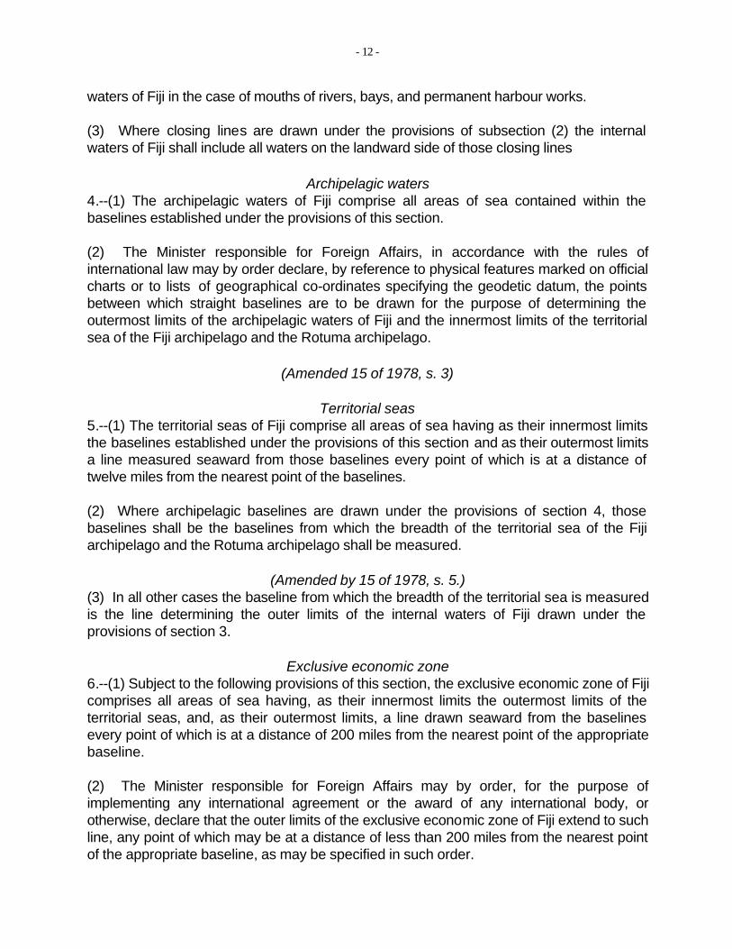
waters of Fiji in the case of mouths of rivers, bays, and permanent harbour works.
(3) Where closing lines are drawn under the provisions of subsection (2) the internal waters of Fiji shall include all waters on the landward side of those closing lines
Archipelagic waters 4.--(1) The archipelagic waters of Fiji comprise all areas of sea contained within the baselines established under the provisions of this section.
(2) The Minister responsible for Foreign Affairs, in accordance with the rules of international law may by order declare, by reference to physical features marked on official charts or to lists of geographical co-ordinates specifying the geodetic datum, the points between which straight baselines are to be drawn for the purpose of determining the outermost limits of the archipelagic waters of Fiji and the innermost limits of the territorial sea of the Fiji archipelago and the Rotuma archipelago.
(Amended 15 of 1978, s. 3)
Territorial seas 5.--(1) The territorial seas of Fiji comprise all areas of sea having as their innermost limits the baselines established under the provisions of this section and as their outermost limits a line measured seaward from those baselines every point of which is at a distance of twelve miles from the nearest point of the baselines.
(2) Where archipelagic baselines are drawn under the provisions of section 4, those baselines shall be the baselines from which the breadth of the territorial sea of the Fiji archipelago and the Rotuma archipelago shall be measured.
(Amended by 15 of 1978, s. 5.) (3) In all other cases the baseline from which the breadth of the territorial sea is measured is the line determining the outer limits of the internal waters of Fiji drawn under the provisions of section 3.
Exclusive economic zone 6.--(1) Subject to the following provisions of this section, the exclusive economic zone of Fiji comprises all areas of sea having, as their innermost limits the outermost limits of the territorial seas, and, as their outermost limits, a line drawn seaward from the baselines every point of which is at a distance of 200 miles from the nearest point of the appropriate baseline.
(2) The Minister responsible for Foreign Affairs may by order, for the purpose of implementing any international agreement or the award of any international body, or otherwise, declare that the outer limits of the exclusive economic zone of Fiji extend to such line, any point of which may be at a distance of less than 200 miles from the nearest point of the appropriate baseline, as may be specified in such order.
- 13 -
(3) Where the median line, as defined in subsection (4), is less than 200 miles from the nearest baseline, and no other line is for the time being specified under the provisions of subsection (2), the outer limits of the exclusive economic zone of Fiji extend to the median line.
(4) The median line is a line every point of which is equidistant from the nearest points of the baselines from which the breadth of the territorial seas of Fiji and of any opposite or adjacent State or territory are measured.
Continental Shelf Act to apply 7. All area of seabed and the subsoil thereof contained within the exclusive economic zone of Fiji are deemed to form part of the continental shelf of Fiji for the purposes of the Continental Shelf Act, and to be subject to the provisions of that Act as if they were areas designated under the provisions of subsection (2) of section 3 of that Act. (Cap. 149)
Charts and publicity 8.--(1) The Minister responsible for Foreign Affairs shall cause all closing lines, baselines and other lines drawn under the provisions of this Act for the purpose of determining the limits of the internal waters, territorial seas and exclusive economic zone of Fiji to be clearly indicated on charts of a scale or scales adequate for them to be readily determined and shall give due publicity to such charts by notice in the Gazette and shall cause a copy of each such chart to be deposited with the Secretary-General of the United Nations.
(2) In any proceedings in any court, a certificate purporting to be signed by the Director of Marine that any specified nautical chart of any area is the largest scale nautical chart of that area produced by any authority and for the time being held by the Minister responsible for marine affairs shall be admissible in evidence of the matters stated in the certificate.
Legal character of marine spaces 9.--(1) The sovereignty of Fiji extends beyond its land territory and internal waters over its archipelagic waters and territorial seas and to the airspace thereover as well as to the seabed and subsoil thereunder.
(2) Within the exclusive economic zone Fiji has sovereign rights for the purpose of exploring and exploiting, conserving and managing the natural resources, whether living or non-living of the seabed and subsoil and the superjacent waters.
(3) The exercise by Fiji of its sovereignty and sovereign rights under the provisions of this section is subject to the rules of international law.
Rights of other States in marine spaces 10.--(1) Subject to the provisions of subsections (2), (3), (4) and (5), ships and aircraft of all States shall, in accordance with the rules of international law, have the right of innocent passage through and over the territorial seas and archipelagic waters.
- 14 -
(2) The Minister responsible for Foreign Affairs may, in accordance with the rules of international law, by order, designate sealanes and air routes, suitable for the continuous and expeditious passage of foreign ships and aircraft, through and over the archipelagic waters and the adjacent territorial seas, and may also prescribe traffic separation schemes for the purpose of ensuring the safe passage of ships through narrow channels in such sealanes.
(3) In such sealanes and air routes all ships and aircraft may, in accordance with the rules of international law, enjoy the right of navigation and overflight, in their normal modes, for the purpose of continuous, expeditious and unobstructed transit through and over the archipelagic waters and the adjacent territorial seas, from one part of the exclusive economic zone to another part of the exclusive economic zone.
(4) Until such time as sealanes or air routes are designated under the provisions of subsection (2) the rights of navigation and overflight referred to in subsection (3) may be exercised through and over all routes normally used for international navigation and overflight.
(5) The rights of navigation and overflight referred to in subsection (3) are subject to all laws of Fiji made in accordance with the rules of international law.
(6) Subject to the provisions of this Act and of any other written law made in accordance with the relevant rules of international law, all States and their nationals shall enjoy, in the exclusive economic zone, the high seas freedoms of navigation and overflight and of the laying of submarine cables and pipelines, and all other internationally lawful uses of the sea related to those freedoms, compatible with the rules of international law.
General regulations in exclusive economic zone 11. Where no other provision is for the time being made in any other written law for any such purpose, the Minister responsible for Foreign Affairs may make regulations, in accordance with the rules of international law, for all or any of the following purposes:--
(a) regulating the conduct of scientific research within the exclusive economic zone;
(b) regulating the exploration and exploitation of the exclusive economic zone for the production of energy from the waters, currents and winds, and for other economic purposes;
(c) regulating the construction, operation and use of artificial islands, installations and structures within the exclusive economic zone, including, but not confined to, the establishment of safety zones around islands, installations and structures;
(d) prescribing measures for the protection and preservation of the marine environment of the exclusive economic zone; and

- 15 -
(e) providing for such other matters as are necessary or expedient to give effect to Fiji's rights and obligations in relation to the exclusive economic zone or are necessary to give full effect to the provisions of this Act, other than matters in respect of which regulations may be made under the provisions of section 22.
PART III--MANAGEMENT AND CONSERVATION OF FISHERIES
Application of Fisheries Act 12.--(1) The archipelagic waters and the waters comprised in the exclusive economic zone shall be part of Fiji fisheries waters as defined in subsection (1) of section 2 of the Fisheries Act and, subject to the provisions of subsection (2), the provisions of that Act shall apply accordingly within the archipelagic waters and the exclusive economic zone. (Cap. 158)
(2) Notwithstanding any other provision in this section or in the Fisheries Act the provisions of that Act relating to the obtaining of licenses to take fish or to the registration of fishing vessels shall not apply to the fishing activities of foreign fishing vessels or their crews in the exclusive economic zone. (Cap. 158)
Calculation and apportionment of allowable catch by foreign fishing vessels 13.--(1) The Minister shall from time to time determine on the basis of the best available information--
(a) the total allowable catch in respect of every fishery within the exclusive economic zone; and
(b) the portion of that catch which Fiji's fishing vessel have the capacity to harvest.
(2) Where the Minister has determined, in respect of the total allowable catch for a fishery within the exclusive economic zone, the portion that Fiji fishing vessels have the capacity to harvest, the remaining portion shall constitute the allowable catch for that fishery for foreign fishing vessels.
(3) The Minister may from time to time apportion, among countries other than Fiji, the allowable catch for foreign fishing vessels in respect of any fishery within the exclusive economic zone, as determined under subsection (2).
(4) In making an apportionment under subsection (3), the Minister may take into account the following considerations:--
(a) whether the fishing vessels of countries to which the apportionment applies have engaged habitually in fishing within the exclusive economic zone;
- 16 -
(b) whether such countries have co-operated with Fiji in fisheries research and in the identification of fish stocks within the exclusive economic zone;
(c) whether such countries have co-operated with Fiji in the conservation and management of fisheries resources within the exclusive economic zone, and in the enforcement of Fiji law relating to such resources;
(d) the terms of any relevant international agreement;
(e) such other matters as the Minister determines to be relevant.
Licensing of foreign fishing vessels 14.-- (1) Subject to the provisions of subsection (2) the Minister may grant and issue licenses authorising foreign fishing vessels to fish in the exclusive economic zone.
(2) In the exercise of his powers under the provisions of this section the Minister shall ensure to the extent of the information available to him that--
(a) the catch that all foreign fishing vessels licensed under this section are for the time being authorised to harvest from any fishery within the exclusive economic zone does not exceed the allowable catch for foreign fishing vessels for that fishery calculated under subsection (2) of section 13;
(b) the catch that all foreign fishing vessels of a particular country licensed under this section are for the time being authorised to harvest from any fishery within the exclusive economic zone does not exceed the apportionment made under subsection (3) of section 13 for that fishery in respect of that country.
(3) A license issued under the provisions of this section shall on payment by the applicant of the prescribed fee, be issued to the owner in respect of a specific boat to be identified by name in the licence and may authorise fishing generally or may confer limited authority by reference to all or any of the following limitations and conditions, namely as to--
(a) the area within which fishing is authorised;
(b) the periods, times or particular voyages during which fishing is authorised;
(c) the descriptions and quantities of fish which may be taken;
(d) the methods by which fish may be taken;
(e) the type of fishing gear which may be used and the stowage of that gear when not in use;
- 17 -
(f) the use, transfer, transhipment, landing and processing of fish taken;
(g) entry by the vessel into Fiji ports;
(h) the compensation payable in the event of any loss or damage caused by the vessel to other fishing boats, gear or catches or to any fish stocks or to other Fiji interests;
(i) statistical and other information required to be given relating to the operations of the vessel including catch and effort statistics and vessel position reports;
(j) the conduct of fisheries research programmes;
(k) the training of Fiji personnel in the methods of fishing employed by the vessel and the transfer to Fiji of fisheries technology;
(l) the production of the license on demand by any fisheries officer;
(m) the markings and other means of identification of the vessel;
(n) the placing of Fiji observers on the vessel;
(o) the carrying on board the vessel of specified nautical charts;
(p) the installation and maintenance in working order on the vessel of position fixing or other identification equipment;
(q) compliance by the vessel with directions and instructions of Fiji ships or aircraft; and
(r) such other conditions as the Minister considers necessary or expedient for the regulation of fishing or the conservation and management of fisheries.
Suspension and cancellation of licences 15.--(1) Where the Minister is satisfied that--
(a) any foreign fishing vessel in respect of which a license has been granted under section 14 is being or has been used for fishing within the exclusive economic zone in contravention of any conditions of the licence or any Fiji law relating to fishing; or
(b) the master, licensee or any crew member of foreign fishing vessel has been convicted of an offence against this Act, or against any regulations made under the provisions of this Act, or against any other Fiji law relating to fishing, he may suspend the licence for such period as he shall specify, or cancel the licence.
(2) Where the Minister determines that it is necessary or expedient for the proper
- 18
regulation of fishing within the exclusive economic zone to do so, he may vary the conditions of or suspend any licence or licences for such period as he shall specify, or he may cancel any licence or licences.
(3) No determination, variation, suspension, cancellation, or other action of the Minister under subsection (2) shall be reviewable by any court of law. (4) While a licence is suspended under this section, it shall have no effect.
Licensing offences 16.--(1) If any foreign fishing vessel that is not licensed under the provisions of section 14 is used for the purpose of fishing within the exclusive economic zone, the owner and the master of the vessel are each guilty of an offence and liable on conviction to a fine not exceeding one hundred thousand dollars each.
(2) If any foreign fishing vessel is used for the purpose of fishing within the exclusive economic zone in contravention of any of the limitations on or conditions of a licence issued under the provisions of section 14, the master and licensee of the vessel are each guilty of an offence and liable on conviction to a fine not exceeding twenty-five thousand dollars each.
Fisheries officers 17.--(1) The following persons shall be fisheries officers for the purpose of this Act, that is to say--
(a) any fisheries officer appointed under the provisions of the Fisheries Act; (Cap. 158.)
(b) any customs officer appointed under the provisions of the Customs Act; (Cap. 196.)
(c) any police officer;
(d) any commissioned officer of the Royal Fiji Military Forces;
(e) any person in command or charge of any vessel or aircraft operated by or on behalf of the Royal Fiji Military Forces; and
(f) any other person appointed as a fisheries officer by the Minister responsible for fisheries matters.
(2) For the purpose of enforcing the provisions of this Act a fisheries officer may exercise in relation to any foreign fishing vessel within the limits of Fiji fisheries waters and in relation to any fishing vessel outside those limits the following powers:--
(a) he may go on board that vessel, and for that purpose may require the vessel to stop and to do anything else which will facilitate the boarding of the vessel;
- 19 -
(b) he may require the attendance before him of the master and other persons on aboard and may make any examination or inquiry which appears to him to be necessary for the purpose of enforcing the provisions of this Act and, in particular--
(i) may search the vessel and examine any fish found on board and the equipment of the vessel, including the fishing gear, and require persons on board the vessel to do anything which appears to him to be necessary to facilitate the examination; and (ii) may require any person on board the vessel to produce any documents relating to that vessel or the persons on board which are in his custody or possession and take copies of any such document.
(3) Where any fisheries officer has reasonable cause to believe that an offence against any of the provisions of section 16 or against any other Fiji law relating to fishing in the exclusive economic zone has been committed in respect of any foreign fishing vessel, he may, without warrant--
(a) arrest any person who he has reason to believe has committed such offence; and
(b) where he has reason to believe that any such offence has been committed by the master or licensee of the vessel, seize and detain a vessel together with all fish found on board and may take the same and the crew of the vessel to the port which appears to him to be the nearest convenient port.
(4) Any fisheries officer may exercise the powers conferred on him by this section with the aid of such assistants as he considers necessary for the purpose.
(5) Where any fishing vessel is detained under the provisions of subsection (3), it shall be held in the custody of the Crown until a decision is made not to institute proceedings in respect of the alleged offence or, if such proceedings are commenced the security required by the provisions of section 19 is given in respect to the vessel.
(6) All fish detained under the provisions of this section shall be held in the custody of the Crown in respect of the alleged offences for which it was detained, or, if such proceedings are instituted, until the proceedings are determined:
Provided that if adequate facilities are not available for the preservation of such fish pending the completion of the proceedings the Minister may take all steps necessary for the sale of such fish at its reasonable market value, the net proceeds of such sale to be paid into a fund to be held by the court in which such proceedings are taken pending the making of a final order by the court in respect of the forfeiture or otherwise of that fish.
(7) The decision whether or not to institute proceedings in respect of an alleged offence for which a foreign fishing vessel is detained under subsection (3) shall be made as soon as reasonably practicable after the vessel is detained.
- 20 -
(8) The release of a foreign fishing vessel from detention shall not affect any subsequent forfeiture of the vessel in respect of the conviction of any person for an offence.
(9) Where a fisheries officer arrests any person under the provisions of subsection (3) he shall cause that person to be taken as soon as reasonably practicable before a court to be dealt with in accordance with law.
Forfeiture of vessels, etc. 18. On conviction of the owner, master or licensee of an offence under section 16, the court may also order the forfeiture to the Crown of the fishing vessel and any fish, fishing gear, apparatus, cargo and stores found therein or thereon.
Security for release of foreign fishing vessel 19.--(1) Where any foreign fishing vessel is detained under section 17, and proceedings are instituted against the master or licensee of the vessel in respect of the offence for which the vessel has been detained, the master or licensee of the vessel or any other person having an interest in the vessel may at any time before the determination of the proceedings apply to the court by which proceedings will be determined for the release of the vessel on the provision of security in accordance with this section.
(2) On hearing the application, the court shall order the release of the foreign fishing vessel on the execution by any suitable person or persons approved by the court for the purpose, of a bond in favour of the Crown, in the prescribed form and conditioned in accordance with subsection (4), in an amount not less than the aggregate of the value of the vessel and the maximum fine to which the defendant will be liable if he is convicted of the offence.
(3) Notwithstanding subsection (2), the court may, where it is satisfied that there are special circumstances to justify it in doing so, order that the bond shall be in a specified amount that is less than the amount required by that subsection.
(4) The condition of the bond shall be that if--
(a) the defendant is found not guilty of the offence; or
(b) the defendant on being convicted of the offence pays in full within fourteen days after he is convicted the amount of the fine imposed by the court and the foreign fishing vessel is within that time surrendered to the Crown for forfeiture if so ordered by the court,
then the bond shall be of no effect, but that otherwise the bond shall remain in full force and effect.
(5) The amount specified in the bond shall be recoverable in full as a debt due to the Crown jointly and severally by the person or persons by whom the bond is given, unless the person or persons prove the due performance of the condition on which the bond is defeasible.
- 21 -
(6) In this section "foreign fishing vessel" includes all equipment on board the vessel.
Obstruction, etc., of fisheries officer 20.--(1) Any person who--
(a) obstructs or hinders any fisheries officer or any person assisting him in the exercise of any of his powers under this Act; or
(b) fails to comply with any lawful requirement imposed or to answer any lawful enquiry made by a fisheries officer under this Act; or
(c) being on board any fishing vessel being pursued or about to be boarded by a fisheries officer, throws overboard or destroys any fish, fishing gear or any other thing whatsoever,
shall be guilty of an offence and liable on conviction to a fine not exceeding five thousand dollars.
(2) If an offence under subsection (1) takes place on board or alongside a fishing vessel, the master of that fishing vessel shall be guilty of a like offence and liable to a like penalty.
Non-liability of fisheries officers 21. No fisheries officer shall be personally liable in respect of any act done or omitted to be done by him in good faith in the execution or purported execution of his powers and duties under this Act.
Regulations 22.--(1) The Minister may make regulations for all or any of the following purposes:--
(a) prescribing the procedure and forms for application for and granting and renewal of licences under the provisions of the Act;
(b) prescribing the terms and duration of licences;
(c) prescribing the forms of licence that may be issued;
(d) prescribing the classes of licences that may be issued which may include different classes of licences, whether by reference to size of vessel, size of catch, method of fishing, species of catch or otherwise;
(e) prescribing the fees payable for licences which may include different fees for different classes of licences;
(f) providing for the production of licences for inspection when required by a fisheries
- 22
inspector or other specified authorities;
(g) prescribing conditions under which foreign fishing vessels may fish in the exclusive economic zone;
(h) prescribing measures for the conservation and management of fisheries resources within the exclusive economic zone;
(i) prescribing measures for ensuring that foreign fishing vessels comply with the limitations and conditions of their licences;
(j) prescribing the manner in which and times when fishing gear is to be stowed;
(k) prescribing the form of bonds for the purpose of section 19;
(l) prescribing measures, not inconsistent with the provisions of this Act, for the regulation of fishing for highly migratory species within Fiji fisheries waters and in the case of Fiji fishing vessels, beyond the limits of those waters; and
(m) providing for such other matters as appear to him to be necessary for giving full effect to Fiji's sovereignty or sovereign rights over Fiji fisheries waters.
(2) For the purpose of this section the expression "highly migratory species" means species that in the course of their life cycle, migrate over great distances of ocean.
Fishing for research and sporting purposes excluded 23. The provisions of this Part shall not apply to nor prohibit or restrict fishing by foreign fishing vessels for fisheries research or sporting purposes with the prior consent in writing of the Minister and in accordance with such conditions as the Minister may impose in giving his consent.
PART IV--MISCELLANEOUS
Offences deemed committed in Fiji 24. Any offence against the provisions of this Act that is committed within the exclusive economic zone shall be deemed to have been committed in Fiji.
Interim measures 25. Pending the entry into force of other provisions of this Act, the Minister may by order prescribe interim or transitional measures for the conservation and management of fisheries resources beyond the territorial seas of Fiji and for the limitation of foreign fishing within an area of two hundred miles from the baselines.
Controlled by the Office of the Prime Minister
_________________________________________________________
- 23
Cap. 158A Ed. 1978 Marine Spaces Subsidiary Legislation
CHAPTER 158A
MARINE SPACES
SECTIONS 3 AND 4--MARINE SPACES (DECLARATION) ORDER Order 12th Apr., 1978
Short title 1. This Order may be cited as the Marine Spaces (Declaration) Order.
Internal waters 2. For the purposes of section 3 of the Act, the physical features by reference to which the points between which closing lines are to be drawn are those shown on British Admiralty Chart No. 2691 or, in the case of Rotuma, on British Admiralty Chart No. 2992, connected by those red lines surrounding areas marked with red hatching.
Archipelagic waters 3.--(1) For the purposes of section 4 of the Act, the physical features by reference to which the points between which straight baselines are to be drawn are those features which are marked with black figures 1 to 12, inclusive on British Admiralty Chart No. 1291.
(2) The Archipelagic basepoints are those which are marked with the red figures 1 to 34, inclusive on the said Chart No. 1291.
Charts 4. The Charts referred to in this Order are the copies kept in the custody of the Solicitor-General with further copies with the Department of Foreign Affairs and the Ministry for Home Affairs.
Controlled by the Office of the Prime Minister
24
ANNEX 2
FIJI ROYAL GAZETTE SUPPLEMENT
No. 41- November 27, 1981
_________________________________________________________
_________________________________________________________
_______
__________________________________________________________
_______
25
FIJI ROYAL GAZETTE SUPPLEMENT
No. 41 FRIDAY 27th NOVEMBER 1981
[Legal Notice No. 116]
MARINE SPACES ACT (Chapter 158A)
DATE OF COMING INTO FORCE OF REMAINING PROVISIONS
In exercise of the powers conferred upon me by section 1 of the Marine Spaces Act, I notify that the remaining provisions of the said Act, that is to say section 6 and Part III, shall come into force on the 1st day of December 1981.
Dated this 19th day of November 1981.
K. K. T. MARAMinister responsible for Foreign Affairs
[Legal Notice No. 117]
MARINE SPACES ACT (Chapter 158A)
MARINE SPACES (ARCHIPELAGIC BASELINES AND EXCLUSIVE ECONOMIC ZONE) ORDER, 1981
In exercise of the powers conferred upon me by sections 4 and 6 of the Marine Spaces Act, I have made the following Order:--
Short title 1. This Order may be cited as the Marine Spaces (Archipelagic Baselines and Exclusive Economic Zone) Order, 1981, and shall come into force on the 1st day of December 1981.
Baselines for the Fiji Archipelago 2. The points between which straight baselines are to be drawn for the purpose of
_______
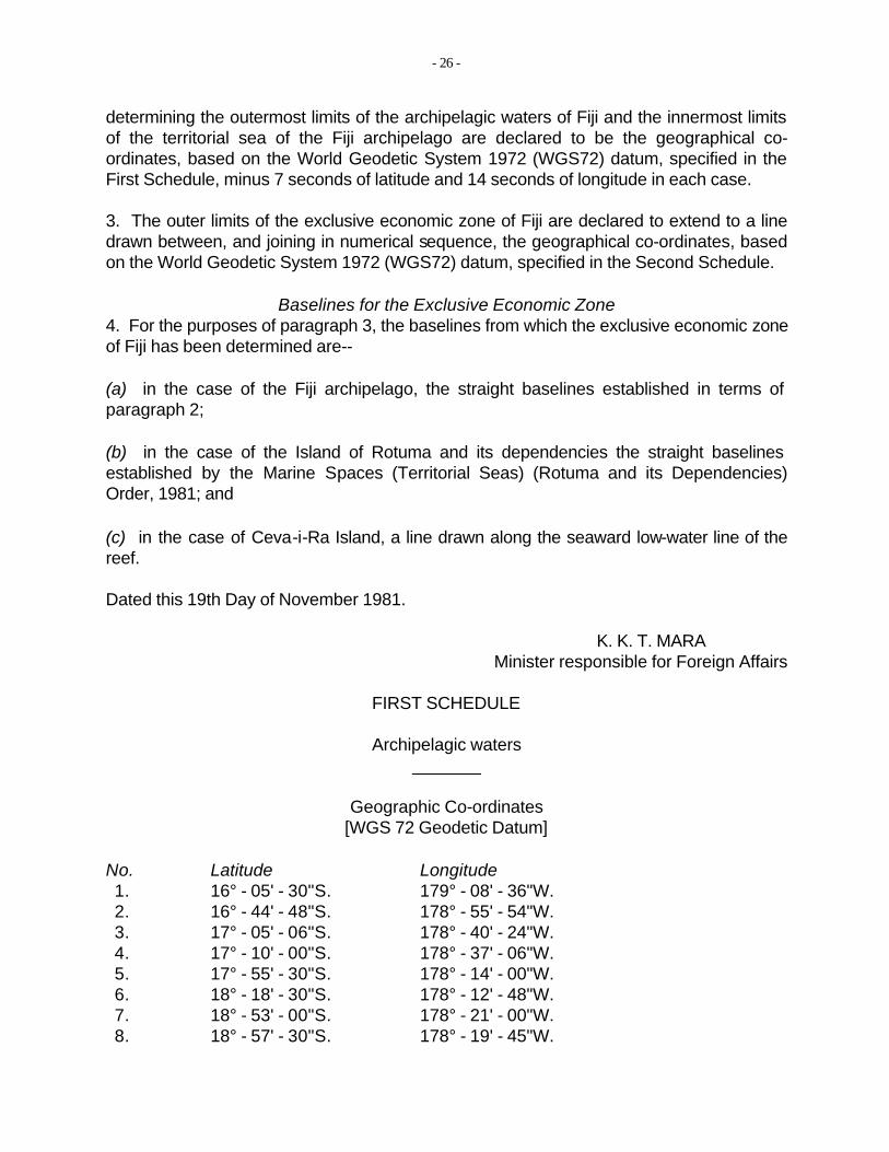
- 26
determining the outermost limits of the archipelagic waters of Fiji and the innermost limits of the territorial sea of the Fiji archipelago are declared to be the geographical coordinates, based on the World Geodetic System 1972 (WGS72) datum, specified in the First Schedule, minus 7 seconds of latitude and 14 seconds of longitude in each case.
3. The outer limits of the exclusive economic zone of Fiji are declared to extend to a line drawn between, and joining in numerical sequence, the geographical co-ordinates, based on the World Geodetic System 1972 (WGS72) datum, specified in the Second Schedule.
Baselines for the Exclusive Economic Zone 4. For the purposes of paragraph 3, the baselines from which the exclusive economic zone of Fiji has been determined are--
(a) in the case of the Fiji archipelago, the straight baselines established in terms of paragraph 2;
(b) in the case of the Island of Rotuma and its dependencies the straight baselines established by the Marine Spaces (Territorial Seas) (Rotuma and its Dependencies) Order, 1981; and
(c) in the case of Ceva-i-Ra Island, a line drawn along the seaward low-water line of the reef.
Dated this 19th Day of November 1981.
K. K. T. MARAMinister responsible for Foreign Affairs
FIRST SCHEDULE
Archipelagic waters
Geographic Co-ordinates [WGS 72 Geodetic Datum]
No. Latitude Longitude 1. 16° - 05' - 30"S. 179° - 08' - 36"W. 2. 16° - 44' - 48"S. 178° - 55' - 54"W. 3. 17° - 05' - 06"S. 178° - 40' - 24"W. 4. 17° - 10' - 00"S. 178° - 37' - 06"W. 5. 17° - 55' - 30"S. 178° - 14' - 00"W. 6. 18° - 18' - 30"S. 178° - 12' - 48"W. 7. 18° - 53' - 00"S. 178° - 21' - 00"W. 8. 18° - 57' - 30"S. 178° - 19' - 45"W.
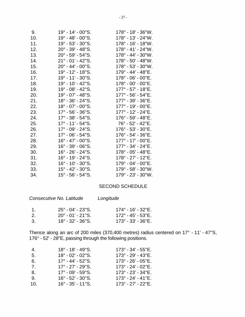
- 27
9. 19° - 14' - 00"S. 10. 19° - 48' - 00"S. 11. 19° - 53' - 30"S. 12. 20° - 39' - 48"S. 13. 20° - 59' - 54"S. 14. 21° - 01' - 42"S. 15. 20° - 44' - 00"S. 16. 19° - 12' - 18"S. 17. 19° - 11' - 30"S. 18. 19° - 10' - 42"S. 19. 19° - 08' - 42"S. 20. 19° - 07' - 48"S. 21. 18° - 36' - 24"S. 22. 18° - 07' - 00"S. 23. 17° - 56' - 36"S. 24. 17° - 38' - 54"S. 25. 17° - 11' - 54"S. 26. 17° - 09' - 24"S. 27. 17° - 06' - 54"S. 28. 16° - 47' - 00"S. 29. 16° - 39' - 06"S. 30. 16° - 26' - 24"S. 31. 16° - 19' - 24"S. 32. 16° - 10' - 30"S. 33. 15° - 42' - 30"S. 34. 15° - 56' - 54"S.
Consecutive No. Latitude
1. 25° - 04' - 23"S. 2. 20° - 01' - 21"S. 3. 18° - 32' - 36"S.
178° - 18' - 36"W.178° - 13' - 24"W.178° - 16' - 18"W.178° - 41' - 24"W.178° - 44' - 30"W.178° - 50' - 48"W.178° - 53' - 30"W.179° - 44' - 48"E.178° - 06' - 00"E.178° - 00' - 00"E.177° - 57' - 18"E.177° - 56' - 54"E.177° - 39' - 36"E.177° - 19' - 00"E.177° - 12' - 24"E.176° - 59' - 48"E. 76° - 52' - 42"E.176° - 53' - 30"E.176° - 54' - 36"E.177° - 17' - 00"E.177° - 34' - 24"E.178° - 05' - 48"E.178° - 27' - 12"E.179° - 04' - 00"E.179° - 58' - 30"W.179° - 23' - 30"W.
SECOND SCHEDULE
Longitude
174° - 16' - 32"E.172° - 45' - 53"E.173° - 33' - 36"E.
Thence along an arc of 200 miles (370,400 metres) radius centered on 17° - 11' - 47"S, 176° - 52' - 28"E, passing through the following positions.
4. 18° - 18' - 49"S. 173° - 34' - 55"E. 5. 18° - 02' - 02"S. 173° - 29' - 43"E. 6. 17° - 44' - 52"S. 173° - 26' - 05"E. 7. 17° - 27' - 29"S. 173° - 24' - 02"E. 8. 17° - 09' - 59"S. 173° - 23' - 34"E. 9. 16° - 52' - 30"S. 173° - 24' - 41"E. 10. 16° - 35' - 11"S. 173° - 27' - 22"E.
35
- 28
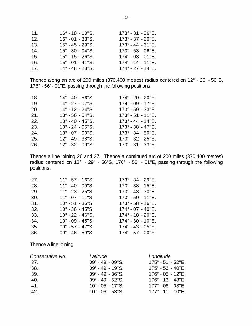
11. 16° - 18' - 10"S. 173° - 31' - 36"E. 12. 16° - 01' - 33"S. 173° - 37' - 20"E. 13. 15° - 45' - 29"S. 173° - 44' - 31"E. 14. 15° - 30' - 04"S. 173° - 53' - 06"E. 15. 15° - 15' - 26"S. 174° - 03' - 01"E. 16. 15° - 01' - 41"S. 174° - 14' - 11"E. 17. 14° - 48' - 28"S. 174° - 27' - 14"E.
Thence along an arc of 200 miles (370,400 metres) radius centered on 12° - 29' - 56"S, 176° - 56' - 01"E, passing through the following positions.
18. 14° - 40' - 56"S. 174° - 20' - 20"E. 19. 14° - 27' - 07"S. 174° - 09' - 17"E. 20. 14° - 12' - 24"S. 173° - 59' - 33"E. 21. 13° - 56' - 54"S. 173° - 51' - 11"E. 22. 13° - 40' - 45"S. 173° - 44' - 14"E. 23. 13° - 24' - 05"S. 173° - 38' - 47"E. 24. 13° - 07' - 00"S. 173° - 34' - 50"E. 25. 12° - 49' - 38"S. 173° - 32' - 25"E. 26. 12° - 32' - 09"S. 173° - 31' - 33"E.
Thence a line joining 26 and 27. Thence a continued arc of 200 miles (370,400 metres) radius centered on 12° - 29' positions.
27. 28. 29. 30. 31. 32. 33. 34.
36.
11° - 57' - 16"S 11° - 40' - 09"S. 11° - 23' - 25"S. 11° - 07' - 11"S. 10° - 51' - 36"S. 10° - 36' - 45"S. 10° - 22' - 46"S. 10° - 09' - 45"S. 09° - 57' - 47"S. 09° - 46' - 59"S.
- 56"S, 176° - 56' - 01"E, passing through the following
173° - 34' - 29"E.173° - 38' - 15"E.173° - 43' - 30"E.173° - 50' - 11"E.173° - 58' - 16"E.174° - 07' - 40"E.174° - 18' - 20"E.174° - 30' - 10"E.174° - 43' - 05"E.174° - 57' - 00"E.
Thence a line joining
Consecutive No. Latitude Longitude 37. 09° - 49' - 09"S. 175° - 51' - 52"E. 38. 09° - 49' - 19"S. 175° - 56' - 40"E. 39. 09° - 49' - 36"S. 176° - 05' - 12"E. 40. 09° - 49' - 52"S. 176° - 13' - 48"E. 41. 10° - 05' - 17"S. 177° - 06' - 03"E. 42. 10° - 06' - 53"S. 177° - 11' - 10"E.
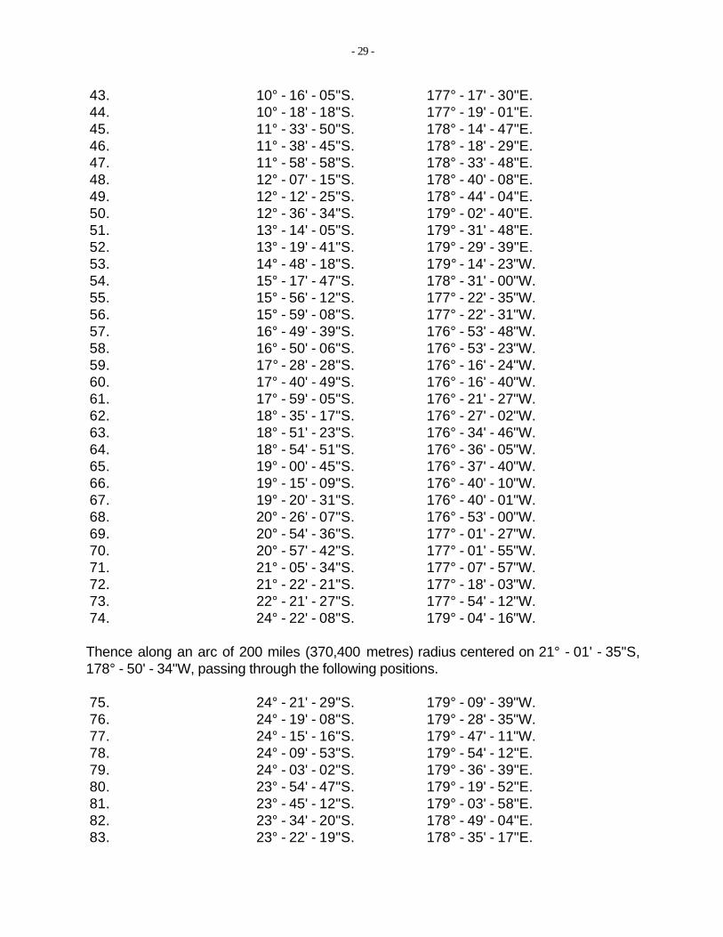
- 29
43. 10° - 16' - 05"S. 177° - 17' - 30"E. 44. 10° - 18' - 18"S. 177° - 19' - 01"E. 45. 11° - 33' - 50"S. 178° - 14' - 47"E. 46. 11° - 38' - 45"S. 178° - 18' - 29"E. 47. 11° - 58' - 58"S. 178° - 33' - 48"E. 48. 12° - 07' - 15"S. 178° - 40' - 08"E. 49. 12° - 12' - 25"S. 178° - 44' - 04"E. 50. 12° - 36' - 34"S. 179° - 02' - 40"E. 51. 13° - 14' - 05"S. 179° - 31' - 48"E. 52. 13° - 19' - 41"S. 179° - 29' - 39"E. 53. 14° - 48' - 18"S. 179° - 14' - 23"W. 54. 15° - 17' - 47"S. 178° - 31' - 00"W. 55. 15° - 56' - 12"S. 177° - 22' - 35"W. 56. 15° - 59' - 08"S. 177° - 22' - 31"W. 57. 16° - 49' - 39"S. 176° - 53' - 48"W. 58. 16° - 50' - 06"S. 176° - 53' - 23"W. 59. 17° - 28' - 28"S. 176° - 16' - 24"W. 60. 17° - 40' - 49"S. 176° - 16' - 40"W. 61. 17° - 59' - 05"S. 176° - 21' - 27"W. 62. 18° - 35' - 17"S. 176° - 27' - 02"W. 63. 18° - 51' - 23"S. 176° - 34' - 46"W. 64. 18° - 54' - 51"S. 176° - 36' - 05"W. 65. 19° - 00' - 45"S. 176° - 37' - 40"W. 66. 19° - 15' - 09"S. 176° - 40' - 10"W. 67. 19° - 20' - 31"S. 176° - 40' - 01"W. 68. 20° - 26' - 07"S. 176° - 53' - 00"W. 69. 20° - 54' - 36"S. 177° - 01' - 27"W. 70. 20° - 57' - 42"S. 177° - 01' - 55"W. 71. 21° - 05' - 34"S. 177° - 07' - 57"W. 72. 21° - 22' - 21"S. 177° - 18' - 03"W. 73. 22° - 21' - 27"S. 177° - 54' - 12"W. 74. 24° - 22' - 08"S. 179° - 04' - 16"W.
Thence along an arc of 200 miles (370,400 metres) radius centered on 21° - 01' - 35"S, 178° - 50' - 34"W, passing through the following positions.
75. 24° - 21' - 29"S. 179° - 09' - 39"W. 76. 24° - 19' - 08"S. 179° - 28' - 35"W. 77. 24° - 15' - 16"S. 179° - 47' - 11"W. 78. 24° - 09' - 53"S. 179° - 54' - 12"E. 79. 24° - 03' - 02"S. 179° - 36' - 39"E. 80. 23° - 54' - 47"S. 179° - 19' - 52"E. 81. 23° - 45' - 12"S. 179° - 03' - 58"E. 82. 23° - 34' - 20"S. 178° - 49' - 04"E. 83. 23° - 22' - 19"S. 178° - 35' - 17"E.
_________________________________________________________
- 30
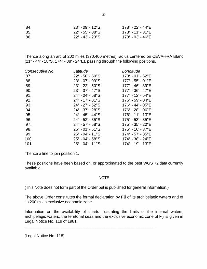
84. 23° - 09' - 12"S. 178° - 22' - 44"E. 85. 22° - 55' - 08"S. 178° - 11' - 31"E. 86. 22° - 43' - 23"S. 178° - 03' - 46"E.
Thence along an arc of 200 miles (370,400 metres) radius centered on CEVA-I-RA Island (21° - 44' - 18"S, 174° - 38' - 24"E), passing through the following positions.
Consecutive No. Latitude Longitude 87. 22° - 50' - 50"S. 178° - 01' - 52"E. 88. 23° - 07' - 09"S. 177° - 55' - 01"E. 89. 23° - 22' - 50"S. 177° - 46' - 39"E. 90. 23° - 37' - 47"S. 177° - 36' - 47"E. 91. 24° - 04' - 58"S. 177° - 12' - 54"E. 92. 24° - 17' - 01"S. 176° - 59' - 04"E. 93. 24° - 27' - 52"S. 176° - 44' - 05"E. 94. 24° - 37' - 28"S. 176° - 28' - 06"E. 95. 24° - 45' - 44"S. 176° - 11' - 13"E. 96. 24° - 52' - 35"S. 175° - 53' - 35"E. 97. 24° - 57' - 58"S. 175° - 35' - 20"E. 98. 25° - 01' - 51"S. 175° - 16' - 37"E. 99. 25° - 04' - 11"S. 174° - 57' - 35"E. 100. 25° - 04' - 58"S. 174° - 38' - 24"E. 101. 25° - 04' - 11"S. 174° - 19' - 13"E.
Thence a line to join position 1.
These positions have been based on, or approximated to the best WGS 72 data currently available.
NOTE
(This Note does not form part of the Order but is published for general information.)
The above Order constitutes the formal declaration by Fiji of its archipelagic waters and of its 200 miles exclusive economic zone.
Information on the availability of charts illustrating the limits of the internal waters, archipelagic waters, the territorial seas and the exclusive economic zone of Fiji is given in Legal Notice No. 119 of 1981.
[Legal Notice No. 118]
_______
______________
- 31
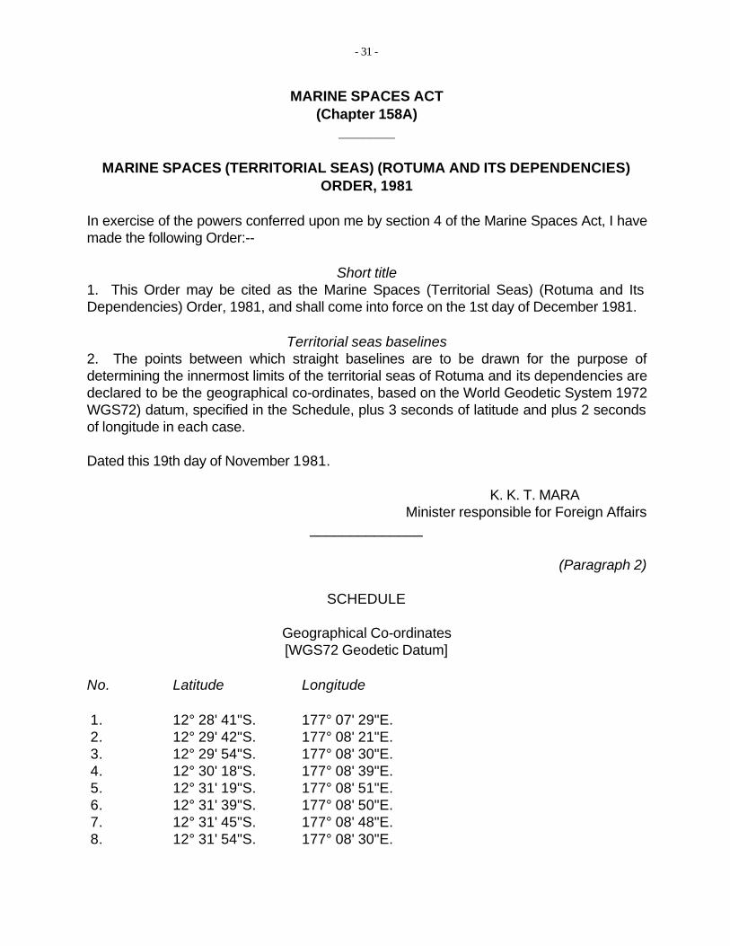
MARINE SPACES ACT (Chapter 158A)
MARINE SPACES (TERRITORIAL SEAS) (ROTUMA AND ITS DEPENDENCIES) ORDER, 1981
In exercise of the powers conferred upon me by section 4 of the Marine Spaces Act, I have made the following Order:--
Short title 1. This Order may be cited as the Marine Spaces (Territorial Seas) (Rotuma and Its Dependencies) Order, 1981, and shall come into force on the 1st day of December 1981.
Territorial seas baselines 2. The points between which straight baselines are to be drawn for the purpose of determining the innermost limits of the territorial seas of Rotuma and its dependencies are declared to be the geographical co-ordinates, based on the World Geodetic System 1972 WGS72) datum, specified in the Schedule, plus 3 seconds of latitude and plus 2 seconds of longitude in each case.
Dated this 19th day of November 1981.
K. K. T. MARAMinister responsible for Foreign Affairs
(Paragraph 2)
SCHEDULE
Geographical Co-ordinates [WGS72 Geodetic Datum]
No. Latitude Longitude
1. 12° 28' 41"S. 177° 07' 29"E. 2. 12° 29' 42"S. 177° 08' 21"E. 3. 12° 29' 54"S. 177° 08' 30"E. 4. 12° 30' 18"S. 177° 08' 39"E. 5. 12° 31' 19"S. 177° 08' 51"E. 6. 12° 31' 39"S. 177° 08' 50"E. 7. 12° 31' 45"S. 177° 08' 48"E. 8. 12° 31' 54"S. 177° 08' 30"E.
_______
_______
- 32
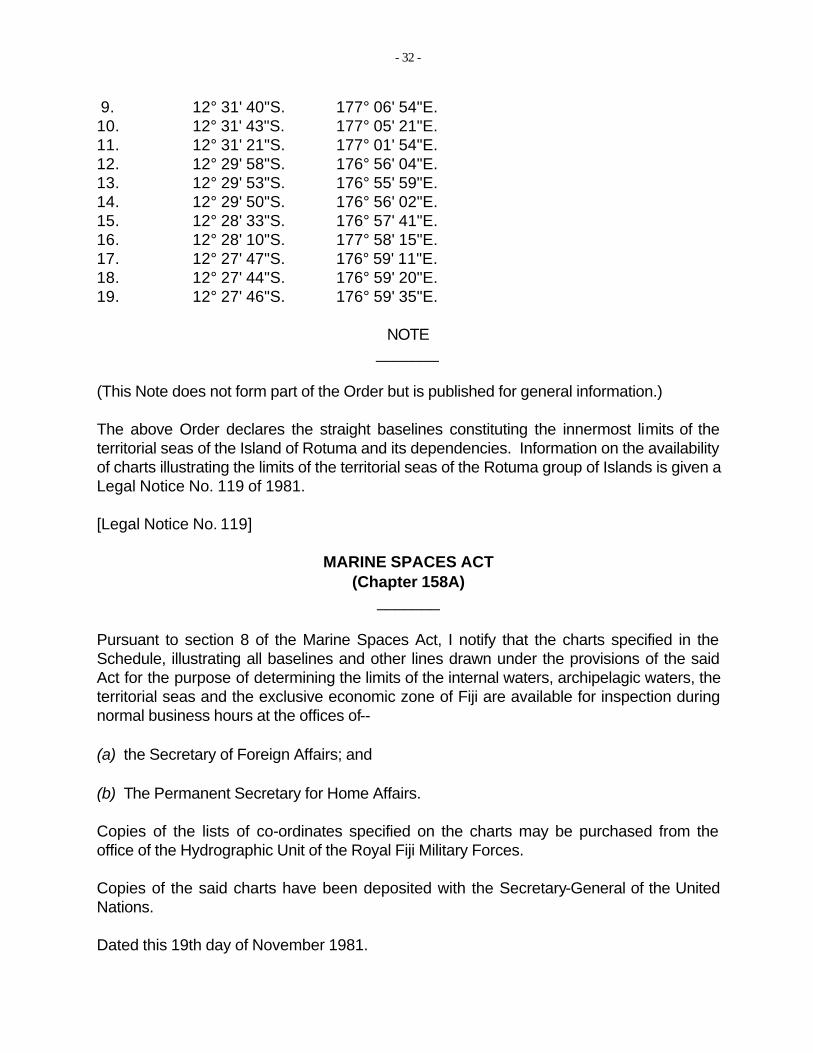
9. 12° 31' 40"S. 177° 06' 54"E. 10. 12° 31' 43"S. 177° 05' 21"E. 11. 12° 31' 21"S. 177° 01' 54"E. 12. 12° 29' 58"S. 176° 56' 04"E. 13. 12° 29' 53"S. 176° 55' 59"E. 14. 12° 29' 50"S. 176° 56' 02"E. 15. 12° 28' 33"S. 176° 57' 41"E. 16. 12° 28' 10"S. 177° 58' 15"E. 17. 12° 27' 47"S. 176° 59' 11"E. 18. 12° 27' 44"S. 176° 59' 20"E. 19. 12° 27' 46"S. 176° 59' 35"E.
NOTE
(This Note does not form part of the Order but is published for general information.)
The above Order declares the straight baselines constituting the innermost limits of the territorial seas of the Island of Rotuma and its dependencies. Information on the availability of charts illustrating the limits of the territorial seas of the Rotuma group of Islands is given a Legal Notice No. 119 of 1981.
[Legal Notice No. 119]
MARINE SPACES ACT (Chapter 158A)
Pursuant to section 8 of the Marine Spaces Act, I notify that the charts specified in the Schedule, illustrating all baselines and other lines drawn under the provisions of the said Act for the purpose of determining the limits of the internal waters, archipelagic waters, the territorial seas and the exclusive economic zone of Fiji are available for inspection during normal business hours at the offices of--
(a) the Secretary of Foreign Affairs; and
(b) The Permanent Secretary for Home Affairs.
Copies of the lists of co-ordinates specified on the charts may be purchased from the office of the Hydrographic Unit of the Royal Fiji Military Forces.
Copies of the said charts have been deposited with the Secretary-General of the United Nations.
Dated this 19th day of November 1981.
_______
_______
- 33
K. K. T. MARAMinister responsible for Foreign Affairs
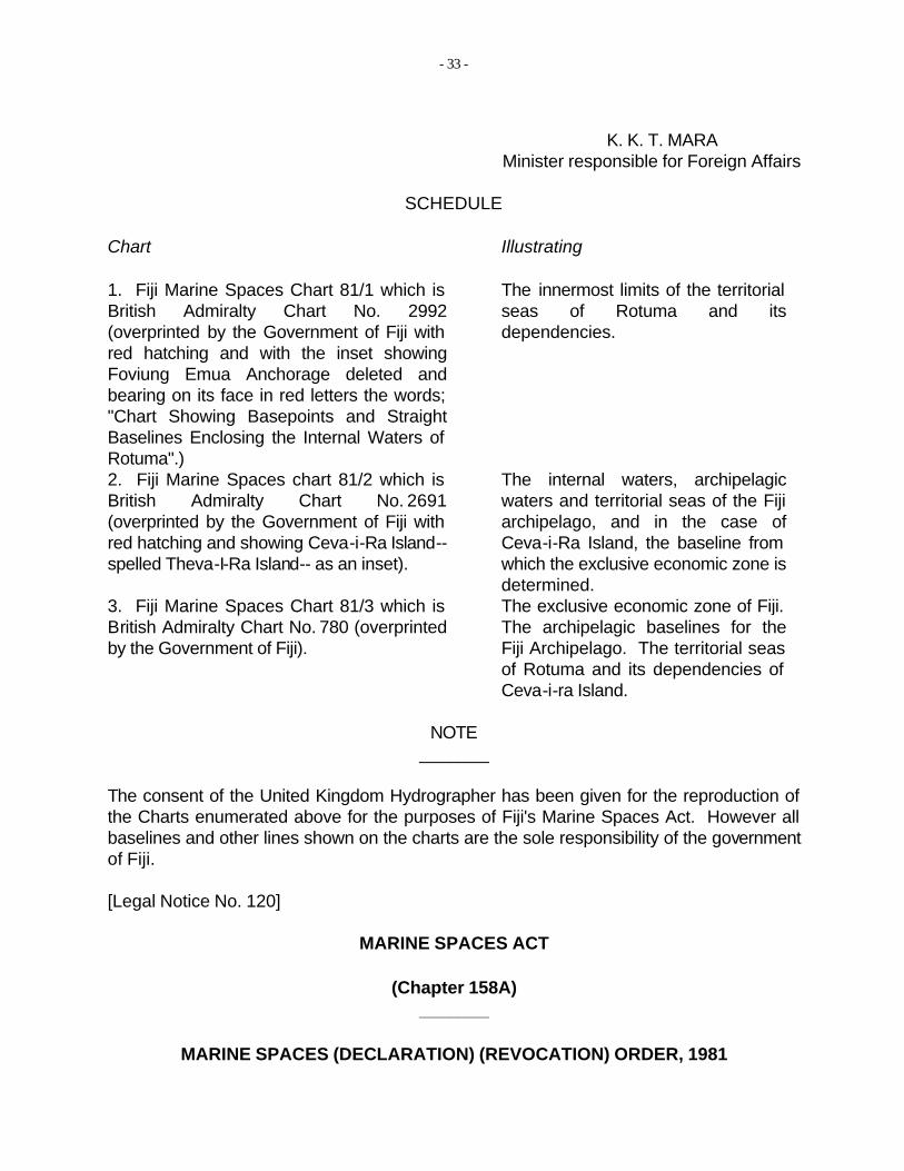
SCHEDULE
Chart Illustrating
1. Fiji Marine Spaces Chart 81/1 which is The innermost limits of the territorial British Admiralty Chart No. 2992 seas of Rotuma and its (overprinted by the Government of Fiji with dependencies. red hatching and with the inset showing Foviung Emua Anchorage deleted and bearing on its face in red letters the words; "Chart Showing Basepoints and Straight Baselines Enclosing the Internal Waters of Rotuma".) 2. Fiji Marine Spaces chart 81/2 which is British Admiralty Chart No. 2691 (overprinted by the Government of Fiji with red hatching and showing Ceva-i-Ra Island--spelled Theva-I-Ra Island-- as an inset).
The internal waters, archipelagic waters and territorial seas of the Fiji archipelago, and in the case of Ceva-i-Ra Island, the baseline from which the exclusive economic zone is determined.
3. Fiji Marine Spaces Chart 81/3 which is The exclusive economic zone of Fiji. British Admiralty Chart No. 780 (overprinted The archipelagic baselines for the by the Government of Fiji). Fiji Archipelago. The territorial seas
of Rotuma and its dependencies of Ceva-i-ra Island.
NOTE
The consent of the United Kingdom Hydrographer has been given for the reproduction of the Charts enumerated above for the purposes of Fiji's Marine Spaces Act. However all baselines and other lines shown on the charts are the sole responsibility of the government of Fiji.
[Legal Notice No. 120]
MARINE SPACES ACT
(Chapter 158A)
MARINE SPACES (DECLARATION) (REVOCATION) ORDER, 1981
_______
_________________________________________________________
_______
- 34
In exercise of the powers conferred upon me by sections 3 and 4 of the Marine Spaces Act, I have made the following Order:--
Short title 1. This Order may be cited as the Marine Spaces (Declaration (Revocation) Order, 1981, and shall come into force on the 1st day of December 1981.
Revocation 2. The Marine Spaces (Declaration) Order (appearing at page 1 of the subsidiary legislation included with Chapter 158A of the 1978 Revised Edition of the Laws) is revoked.
Dated this 19th day of November 1981.
K. K. T. MARAMinister responsible for Foreign Affairs
NOTE
(This Note does not form part of the Order but is published for general information.)
The above Order revokes the Order originally published as Legal Notice No. 56 of 1978 which has been rendered superfluous by virtue of the Marine Spaces (Declaration of Archipelagic Waters and Exclusive Economic Zone) Order, 1981 (Legal Notice No. 117 of 1981).
[Legal Notice No. 121]
FISHERIES (AMENDMENT) ACT, 1977 (No. 22 of 1977)
DATE OF COMING INTO FORCE
In exercise of the powers conferred upon me by section 1 of the Fisheries (Amendment) Act, 1977, I notify that the said Act shall come into force on the 1st day of December 1981.
Dated this 20th day of November 1981.
J. MAVOA
Minister for Agriculture and Fisheries
_______
_______
_______
- 35
NOTE
(This Note does not form part of the above Legal Notice but is published for general information.)
This Legal Notice brings into force the Fisheries (Amendment) Act, 1977. The amendments made by the Act have been incorporated into the text of the principal Act which appears as Chapter 158 of the 1978 Revised Edition of the Laws. [Legal Notice No. 122]
MARINE SPACES ACT (Chapter 158A)
MARINE SPACES (FOREIGN FISHING VESSELS) REGULATIONS, 1979
DATE OF COMING INTO FORCE
In exercise of the powers conferred upon me by regulation 1 of the Marine Spaces (Foreign Fishing Vessels) Regulations, 1979, I notify that the said Regulations shall come into force on the 1st day of December 1981.
Dated this 20th day of November 1981.
J. MAVOAMinister for Agriculture and Fisheries
36
Annex 3
Distances Between Archipelagic Baseline Turning Points* (in nautical miles)
Turning Points Distance1–2 41.12-3 25.13–4 5.84–5 50.75–6 22.96–7 35.47–8 4.78–9 16.5
9–10 34.410–11 6.111–12 51.912–13 20.313–14 6.314–15 17.915–16 119.916–17 93.417-18 5.7
Turning Points Distance 18–19 3.2 19–20 1.0 20–21 35.4 21–22 35.3 22–23 12.1 23–24 21.4 24–25 27.8 25–26 2.6 26–27 2.7 27–28 29.2 28–29 18.4 29–30 32.7 30–31 21.7 31–32 36.4 32–33 62.4 33–34 36.6
* The geographic coordinates for the turning points are listed in Annex 2, Legal Notice No. 117.
Annex 4
Distances Between Rotuma's Straight Baseline Turning Points* (in nautical miles)
Turning Points Distance1–2 1.332-3 0.253–4 0.434–5 1.045–6 0.336–7 0.107–8 0.338–9 1.58
9–10 1.51 10–11 3.39
Turning Points Distance 11–12 5.86 12–13 0.13 13–14 0.07 14–15 2.05 15–16 0.68 16–17 0.99 17–18 0.15 18–19 0.25 19–1 7.77
* The geographical coordinates for the turning points are listed in Annex 2, Legal Notice No. 118.