Linear Referencing? - MAGTUG · • An event can be any type of table supported by ArcGIS....
28
UC 2007 Tech Sessions UC 2007 Tech Sessions 1 1 Linear Referencing? Linear Referencing? • • Method of storing geographic features by using Method of storing geographic features by using relative relative positions positions along a measured line feature along a measured line feature • • Distance measures are used to locate features along the Distance measures are used to locate features along the line line • • Supported by methods and tools for storage, Supported by methods and tools for storage, maintenance, query and analysis, display maintenance, query and analysis, display x,y,m x,y,m x,y,m x,y,m x,y,m x,y,m
Transcript of Linear Referencing? - MAGTUG · • An event can be any type of table supported by ArcGIS....

UC 2007 Tech SessionsUC 2007 Tech Sessions 11
Linear Referencing?Linear Referencing?
•• Method of storing geographic features by using Method of storing geographic features by using relative relative
positionspositions along a measured line featurealong a measured line feature
•• Distance measures are used to locate features along the Distance measures are used to locate features along the
lineline
•• Supported by methods and tools for storage, Supported by methods and tools for storage,
maintenance, query and analysis, displaymaintenance, query and analysis, display
x,y,m
x,y,m x,y,m
x,y,m x,y,mx,y,m

UC 2007 Tech SessionsUC 2007 Tech Sessions 22
Linear Referencing ApplicationsLinear Referencing Applications
•• Reference features using a linear system of measures to Reference features using a linear system of measures to
determine locations in geographic spacedetermine locations in geographic space
–– i.ei.e instead of using instead of using xyxy coordinates, locate positions with linear coordinates, locate positions with linear
measure valuesmeasure values
Main St.15
40 60 8095
20
Accident occurred 50 meters along
Main St

UC 2007 Tech SessionsUC 2007 Tech Sessions 33
Linear Referencing ApplicationsLinear Referencing Applications
•• Features containing 1:M relationshipsFeatures containing 1:M relationships
–– i.ei.e when two or more pieces of information are associated with the when two or more pieces of information are associated with the
same location on a linear featuresame location on a linear feature
Lanes2 4
MaterialAsphalt AsphaltConcrete
Speed45 35 45 55
Main St.15
40 60 8095
20

UC 2007 Tech SessionsUC 2007 Tech Sessions 44
concrete asphaltMaterial
Qualityfair good poor
Main St15
40 60 8095
20
concrete asphaltMaterial
Qualitygood fair good poor
Main St15
40 60 8095
20
concrete asphaltMaterial
Qualityfair good poor
Main St.15
40 60 8095
20
•• Features containing frequently segmented dataFeatures containing frequently segmented data
–– i.ei.e some types of features have attributes that change frequentlysome types of features have attributes that change frequently
Linear Referencing ApplicationsLinear Referencing Applications

UC 2007 Tech SessionsUC 2007 Tech Sessions 55
RoutesRoutes
•• Linear features Linear features –– in a in a polylinepolyline feature classfeature class
•• Have an Have an identifieridentifier and and measurement systemmeasurement system
•• Stored in a geodatabase, shapefile, or coverageStored in a geodatabase, shapefile, or coverage
Route
711081
Unique identifierUnique identifierLinear featureLinear feature

UC 2007 Tech SessionsUC 2007 Tech Sessions 66
MeasuresMeasures
•• Measures or M valuesMeasures or M values
–– Distances along a linear featureDistances along a linear feature
–– Store with X and Y coordinateStore with X and Y coordinate
–– Measures start at route originMeasures start at route origin
x,y,m
x,y,m x,y,m
x,y,m x,y,mx,y,m

UC 2007 Tech SessionsUC 2007 Tech Sessions 77
Measure UnitsMeasure Units
•• Can be miles, meters, feet, time, etc.Can be miles, meters, feet, time, etc.
•• Units do not have to match the Units do not have to match the x,yx,y unitsunits
•• Every vertex has a measure (M)Every vertex has a measure (M)
–– NaNNaN (Not a Number) means no measure(Not a Number) means no measure
•• Measures can increase, remain constant or decreaseMeasures can increase, remain constant or decrease
0.0
1.2
2.3
3.5
NaN
5.1
UC 2007 Tech SessionsUC 2007 Tech Sessions 88
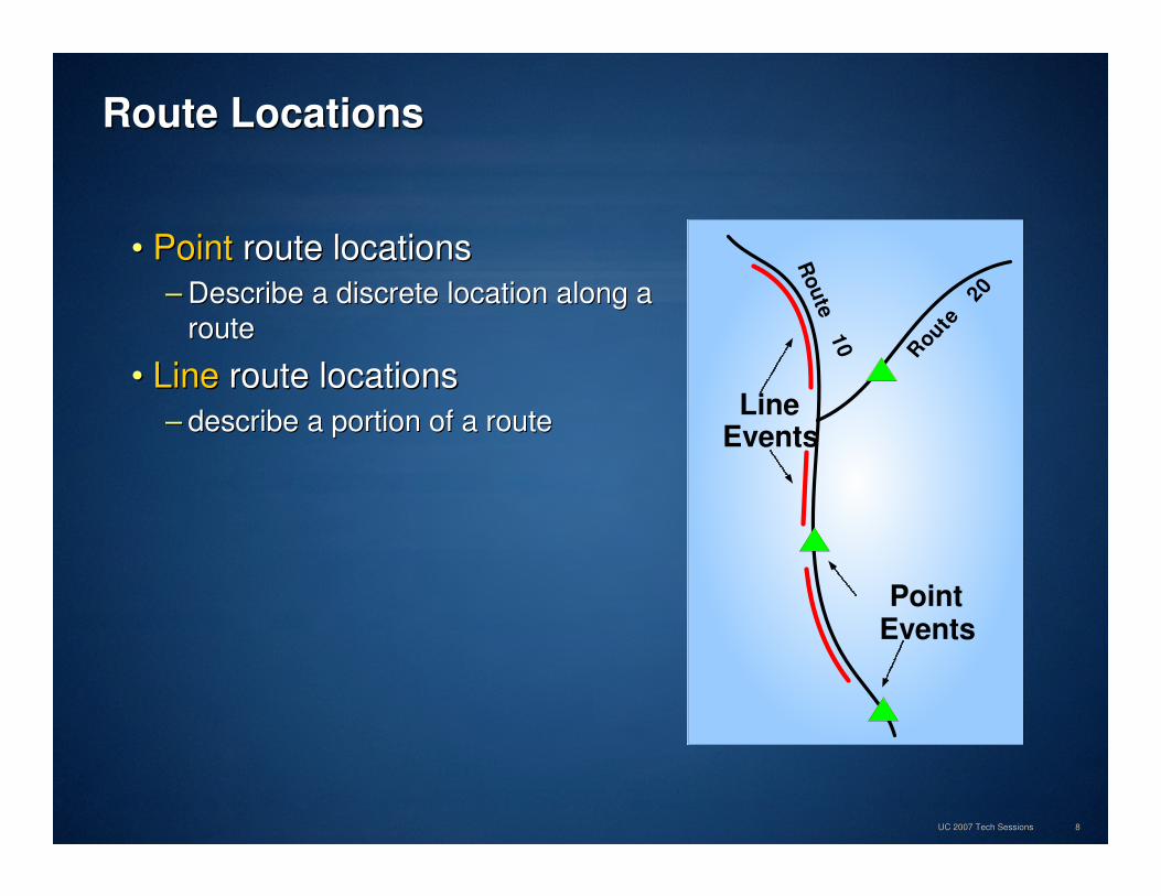
Route LocationsRoute Locations
•• PointPoint route locationsroute locations
–– Describe a discrete location along a Describe a discrete location along a
route route
•• LineLine route locationsroute locations
–– describe a portion of a routedescribe a portion of a routeLine
Events
PointEvents
Rou
te10
Route
20

UC 2007 Tech SessionsUC 2007 Tech Sessions 99
Event TablesEvent Tables
•• Route locations thematically stored in tables are called Route locations thematically stored in tables are called
““route eventsroute events”” or simply or simply ““eventsevents””. .
–– PointPoint event table event table –– i.ei.e Accidents, seismic Accidents, seismic shotpointsshotpoints
–– LineLine event table event table –– pavement conditions, riverbank compositionpavement conditions, riverbank composition
•• An event can be any type of table supported by ArcGIS.An event can be any type of table supported by ArcGIS.
–– Geodatabase, info, dBase, text, OLE DB Geodatabase, info, dBase, text, OLE DB

UC 2007 Tech SessionsUC 2007 Tech Sessions 1010
Point Event TablesPoint Event Tables
•• Two required fieldsTwo required fields
–– Route IDRoute ID identifies route on which event is locatedidentifies route on which event is located
–– MeasureMeasure is the eventis the event’’s location on the routes location on the route
•• Other attributes about the eventOther attributes about the event
Route location Attributes
Point event table
Route 1
4
14
34
45
53
0
60

UC 2007 Tech SessionsUC 2007 Tech Sessions 1111
Line Event TablesLine Event Tables
•• Three required fieldsThree required fields
–– Route IDRoute ID identifies route on which event is locatedidentifies route on which event is located
–– From MeasureFrom Measure and and To MeasureTo Measure define beginning and end of line define beginning and end of line
eventevent
•• Other attributes about the eventOther attributes about the event
Route 48
0
25
0
60
Route location Attributes
Line event table

UC 2007 Tech SessionsUC 2007 Tech Sessions 1212
Dynamic SegmentationDynamic Segmentation
•• ““The process of computing map locations of events on The process of computing map locations of events on linear features at run time so they can be displayed, linear features at run time so they can be displayed, queried, and queried, and analysedanalysed using a GISusing a GIS

UC 2007 Tech SessionsUC 2007 Tech Sessions 1313
Dynamic SegmentationDynamic Segmentation
•• Use the Use the MakeRouteEventLayerMakeRouteEventLayer tooltool
•• The The DynSegDynSeg process adds a feature layer to a mapprocess adds a feature layer to a map
–– Dynamic feature class created behind the scenesDynamic feature class created behind the scenes
•• AdvantagesAdvantages
–– Underlying route is not Underlying route is not
broken apartbroken apart
–– Events behave like any Events behave like any
other feature layerother feature layer
•• Display using custom Display using custom
symbologysymbology
•• Perform GIS analysisPerform GIS analysis
•• Save as a layer fileSave as a layer file
•• Export to feature classExport to feature class

UC 2007 Tech SessionsUC 2007 Tech Sessions 1414
DemonstrationDemonstration
•• RoutesRoutes
•• MeasuresMeasures
•• EventsEvents
•• Dynamic SegmentationDynamic Segmentation
A45
A307
B7
D23 F478

UC 2007 Tech SessionsUC 2007 Tech Sessions 1515
Route Event Analysis ToolsRoute Event Analysis Tools
• Overlay events.
• Dissolve/Concatenate events.
• Transform events.
• Locate features along routes.

UC 2007 Tech SessionsUC 2007 Tech Sessions 1616
Dissolve/Concatenate EventsDissolve/Concatenate Events
• Concatenate: remove redundant information from a table•• Concatenate: Concatenate: remove redundant information from a tableremove redundant information from a table
• Dissolve: split tables having more than one descriptive attribute•• Dissolve:Dissolve: split tables having more than one descriptive attributesplit tables having more than one descriptive attribute
UC 2007 Tech SessionsUC 2007 Tech Sessions 1717
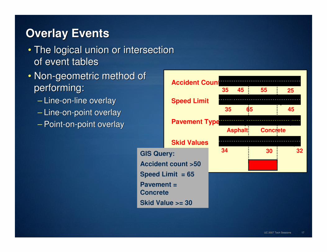
Overlay EventsOverlay Events
•• The logical union or intersection The logical union or intersection
of event tablesof event tables
•• NonNon--geometric method of geometric method of
performing:performing:
–– LineLine--onon--line overlayline overlay
–– LineLine--onon--point overlaypoint overlay
–– PointPoint--onon--point overlaypoint overlay
Asphalt
Accident Count
Speed Limit
Pavement Type
Skid Values
35 45 55
4535 65
Asphalt Concrete
34 30 32
25
GIS Query:
Accident count >50
Speed Limit = 65
Pavement =
Concrete
Skid Value >= 30

UC 2007 Tech SessionsUC 2007 Tech Sessions 1818
Transform EventsTransform Events
•• Transform event measures Transform event measures -- one route to anotherone route to another
•• Used for multiple linear referencing methodsUsed for multiple linear referencing methods
•• Also used to keep events up to date after reAlso used to keep events up to date after re--alignmentsalignments
0
2.5
102
105

UC 2007 Tech SessionsUC 2007 Tech Sessions 1919
Locate Features Along RoutesLocate Features Along Routes
•• Create event tables by locating features along a route.Create event tables by locating features along a route.
•• Preserves attributes of input features.Preserves attributes of input features.
•• Results in a new event table.Results in a new event table.
–– Locating Points Locating Points �� Point Event TablePoint Event Table
–– Locating Lines or polygons Locating Lines or polygons �� Line Event TableLine Event Table
Route locationPoint
Attributes
Distance field is optional

UC 2007 Tech SessionsUC 2007 Tech Sessions 2020
DemonstrationDemonstration
•• Find and Identify Route LocationsFind and Identify Route Locations
•• Route event analysisRoute event analysis
A45
A307
B7
D23 F478

UC 2007 Tech SessionsUC 2007 Tech Sessions 2121
Linear Referencing Linear Referencing –– Creating and MaintainingCreating and Maintaining
•• Creating routesCreating routes
•• Calibrating routesCalibrating routes
•• Editing routesEditing routes
A45
A307
B7
D23 F478

UC 2007 Tech SessionsUC 2007 Tech Sessions 2222
Creating RoutesCreating Routes
•• Routes are created byRoutes are created by–– Merging linear features based on common identifiersMerging linear features based on common identifiers
–– Setting measures based on one or two fields Setting measures based on one or two fields
•• Create routesCreate routes–– By creating a new empty feature class and loading dataBy creating a new empty feature class and loading data
–– By creating a new route feature class from existing line featureBy creating a new route feature class from existing line featuress
–– By converting an existing route feature classBy converting an existing route feature class
•• Create routes usingCreate routes using–– ArcToolbox (ArcToolbox (CreateRoutesCreateRoutes and and CalibrateRoutesCalibrateRoutes tools)tools)
–– ArcCatalogArcCatalog
–– ArcMapArcMap

UC 2007 Tech SessionsUC 2007 Tech Sessions 2323
Create a Route Feature Class from ScratchCreate a Route Feature Class from Scratch
•• Follow standard procedures for creating a feature classFollow standard procedures for creating a feature class
Enable M storageEnable M storage
Set geometry typeSet geometry typeDefine route identifier
field
Define route identifier field

UC 2007 Tech SessionsUC 2007 Tech Sessions 2424
Create a Route Feature Class from Existing LinesCreate a Route Feature Class from Existing Lines
Measure field(s) or Geometric Length
Measure field(s) or Geometric Length
Input featuresInput features
Route ID fieldRoute ID field
Output featuresOutput features
•• CreateRoutesCreateRoutes tooltool

UC 2007 Tech SessionsUC 2007 Tech Sessions 2525
Calibrate RoutesCalibrate Routes
510
18
301525
0.0
55.6
20
510
18
3015
25
35.2
1.2
•• Recalculate measures along route Recalculate measures along route
using pointsusing points

UC 2007 Tech SessionsUC 2007 Tech Sessions 2626
Editing RoutesEditing Routes
Sketch PropertiesSketch Properties
Tasks for linear referencing
Tasks for linear referencing
Route Editing toolbar
Route Editing toolbar
Define line portion
Define line portion
Make RouteMake Route
Calibrate Route
Calibrate Route
•• Edit routes just like any Edit routes just like any
polylinepolyline..
–– Extend, delete, split, Extend, delete, split,
rere--align, copy a routealign, copy a route

UC 2007 Tech SessionsUC 2007 Tech Sessions 2727
Route Route MaintainanceMaintainance
•• Routes are a feature classRoutes are a feature class
•• Calibrate with field dataCalibrate with field data
•• Use topology to manage multiple Use topology to manage multiple LRMsLRMs on one set of roadson one set of roads
–– Many departments will maintain their own route and event data.Many departments will maintain their own route and event data.
RoutesRoutes
Event
Data
TopologyTopology
RulesRules
RoutesRoutes
Event
Data
RoutesRoutes
Event
Data
RoadsRoads

UC 2007 Tech SessionsUC 2007 Tech Sessions 2828
Linear Referencing ToolsLinear Referencing Tools
•• Create routesCreate routes–– Create and calibrate routes.Create and calibrate routes.
–– Convert existing routes. Convert existing routes.
•• Route display and queryRoute display and query–– Find route locations.Find route locations.
–– Identify route locations.Identify route locations.
–– Hatching.Hatching.
–– Route measure anomalies.Route measure anomalies.
•• Event display and queryEvent display and query–– ‘‘Dynamic SegmentationDynamic Segmentation’’
–– Event matching statistics.Event matching statistics.
–– Locating angles.Locating angles.
•• Event AnalysisEvent Analysis–– Overlay events.Overlay events.
–– Event transform.Event transform.
–– Dissolve/Concatenate events.Dissolve/Concatenate events.
–– Locate features along routes.Locate features along routes.
•• Editing routes in ArcMapEditing routes in ArcMap–– Route creation.Route creation.
–– Edit tasks.Edit tasks.
–– Measure editing tools.Measure editing tools.