Lindstrom, MN Code of Ordinances PUD, PLANNED UNIT · PDF fileLindstrom, MN Code of Ordinances...
30
Lindstrom, MN Code of Ordinances PUD, PLANNED UNIT DEVELOPMENT § 154.200 PURPOSE. The purpose of the Planned Unit Development District is to provide a district that will encourage the following. (A) Flexibility in land development and redevelopment in order to utilize new techniques of building design, construction and land development; (B) Provision of life cycle housing to all income and age groups; (C) Energy conservation through the use of more efficient building designs and sitings and the clustering of buildings and land uses; (D) Preservation of desirable site characteristics and open space and protection of sensitive environmental features, including, but not limited to steep slopes, trees, wetlands and the like; (E) More efficient and effective use of land, open space and public facilities through mixing of land uses and assembly and development of land into larger parcels; (F) High quality of design and design compatible with surround land uses, including both existing and planned; (G) Sensitive development in transitional areas located between different land uses and along significant transportation or scenic corridors within the city; and (H) Development which is consistent with the comprehensive plan. (`87 Code, § 1001.14) (Ord. passed 4-21-2016) § 154.201 CLASSIFICATIONS; PERMITTED USES. (A) Upon rezoning for a PUD, the district shall be designated by the letters “PUD” followed by the alphanumeric designation of the underlying zoning district which may be either the prior zoning classification or a new classification. In cases of mixed use PUDs, the City Council shall, whenever reasonably practicable, specify the underlying zoning classifications for the various parts of the PUD. When it is not reasonably practicable to so specify underlying zoning classifications, the Council may rezone the district, or any part thereof, to “PUD Mixed.” (B) Regulations governing uses and structures in PUDs shall be the same as those governing the underlying zoning district subject to the following: (1) Regulations, except shoreland regulations in Section 154.205, may be modified expressly by conditions imposed by the Council at the time of rezoning to PUD; and (2) In the case of districts rezoned to “PUD Mixed,” the Council shall specify regulations applicable to uses and structures in various parts of the district. (C) For purposes of determining applicable regulations for uses or structures on land adjacent to or in the vicinity of the PUD district which depend on the zoning of the PUD district, the underlying zoning classification of PUD districts shall be deemed to be the zoning classification of the district. In the case of a district zoned “PUD Mixed,” the underlying zoning classification shall be deemed to be the classification which allows as a permitted use any use which is permitted in the PUD district and which results in the most restrictive regulation of adjacent or nearby properties.
Transcript of Lindstrom, MN Code of Ordinances PUD, PLANNED UNIT · PDF fileLindstrom, MN Code of Ordinances...

Lindstrom, MN Code of Ordinances
PUD, PLANNED UNIT DEVELOPMENT
§ 154.200 PURPOSE.
The purpose of the Planned Unit Development District is to provide a district that will encourage
the following.
(A) Flexibility in land development and redevelopment in order to utilize new techniques of
building design, construction and land development;
(B) Provision of life cycle housing to all income and age groups;
(C) Energy conservation through the use of more efficient building designs and sitings and the
clustering of buildings and land uses;
(D) Preservation of desirable site characteristics and open space and protection of sensitive
environmental features, including, but not limited to steep slopes, trees, wetlands and the
like;
(E) More efficient and effective use of land, open space and public facilities through mixing of
land uses and assembly and development of land into larger parcels;
(F) High quality of design and design compatible with surround land uses, including both
existing and planned;
(G) Sensitive development in transitional areas located between different land uses and along
significant transportation or scenic corridors within the city; and
(H) Development which is consistent with the comprehensive plan.
(`87 Code, § 1001.14) (Ord. passed 4-21-2016)
§ 154.201 CLASSIFICATIONS; PERMITTED USES.
(A) Upon rezoning for a PUD, the district shall be designated by the letters “PUD” followed by
the alphanumeric designation of the underlying zoning district which may be either the prior
zoning classification or a new classification. In cases of mixed use PUDs, the City Council
shall, whenever reasonably practicable, specify the underlying zoning classifications for the
various parts of the PUD. When it is not reasonably practicable to so specify underlying
zoning classifications, the Council may rezone the district, or any part thereof, to “PUD
Mixed.”
(B) Regulations governing uses and structures in PUDs shall be the same as those governing the
underlying zoning district subject to the following:
(1) Regulations, except shoreland regulations in Section 154.205, may be modified
expressly by conditions imposed by the Council at the time of rezoning to PUD; and
(2) In the case of districts rezoned to “PUD Mixed,” the Council shall specify
regulations applicable to uses and structures in various parts of the district.
(C) For purposes of determining applicable regulations for uses or structures on land adjacent to
or in the vicinity of the PUD district which depend on the zoning of the PUD district, the
underlying zoning classification of PUD districts shall be deemed to be the zoning
classification of the district. In the case of a district zoned “PUD Mixed,” the underlying
zoning classification shall be deemed to be the classification which allows as a permitted
use any use which is permitted in the PUD district and which results in the most restrictive
regulation of adjacent or nearby properties.

(D) When any parcel of land is considered, as a whole, for designation as a PUD district and the
PUD designation is subsequently approved, the parcel may not be further subdivided unless
the future subdivision is fully discussed, tentatively approved and the tentative approval
noted in the meeting minutes at the time of the initial consideration.
(`87 Code, § 1001.14) (Ord. passed 4-21-2016)
§ 154.202 DEVELOPMENT STANDARDS.
(A) Minimum area. A PUD shall have a minimum area of one acre, excluding wetlands and
land lying below the ordinary high watermark of any lake and excluding existing rights-of-way
unless the city finds that at least one of the following conditions exist:
(1) There are unusual physical features of the property or of the surrounding neighborhood
such that development as a PUD will conserve a physical or terrain feature of importance to the
neighborhood or community;
(2) The property is directly adjacent to or across a public right-of-way from property that
previously was developed as a PUD and the new PUD will be perceived as and function as an
extension of that previously approved development; or
(3) The property is located in a transitional area between different land uses and development
will be used as a buffer between the uses.
(B) Overall density. Within a PUD, overall density for residential developments shall be
consistent with §§ 154.215 through 154.230, Shoreland District regulations. Individual
buildings or lots within a PUD may exceed these standards, provided that density for the entire
PUD does not exceed the permitted standards. For instance, under no circumstances shall the
total density of a single-family residential PUD exceed the maximum density of one dwelling
unit per each 12,000 square feet (15,000 square feet for riparian lots) of land excluding the total
square footage of parks and other public rights-of-way.
(C) Consistency with Underlying Zoning District. Setbacks, tree planting and other similar
requirements within a PUD shall be consistent with the requirements of the underlying zoning
district unless the developer can demonstrate to the city's satisfaction that an alternate plan
with the addition of screening treatment or other mitigative measures would be to the
advantage of the city.
(D) Open space. PUDs must contain open space meeting all of the following criteria. PUDs
located in the Shoreland District must meet all the following criteria, plus those identified in §
154.205(F)(2).
(1) At least 50% of the total project area must be preserved as open space.
(2) Road rights-of-way or land covered by road surfaces, parking areas, structures or
footprints reserved for future structures future structure sites are developed areas and shall not
be included in the computation of minimum open space.
(3) Open space must include areas with physical characteristics unsuitable for development in
their natural state, and areas containing significant historic sites such as unplatted cemeteries.
(4) Open space may include pervious outdoor recreation facilities for use by owners of
dwelling units or sites, by customers/guests in commercial PUDs and by the general public.
(E) Open space preservation. Deed restrictions, covenants, permanent easements, public
dedication and acceptance or other equally effective and permanent means must be provided to
ensure long term preservation and maintenance of open space. The instruments must include
all of the following protections:
(1) Commercial uses shall be prohibited in residential PUDs;

(2) Reducing vegetation and topographical alterations other than routine maintenance shall
be prohibited;
(3) Construction of additional buildings or storage of vehicles, vessels and any other items or
materials shall be prohibited; and
(4) Uncontrolled beaching of watercraft shall be prohibited.
(F) Impervious surface requirements. The impervious surface requirements of PUDs shall not
exceed that of the underlying zoning district or Section 154.221(F)(8) if it is in a shoreland
area.
(G) Erosion Control and Stormwater Management.
(1) Proposals submitted must include an erosion control and stormwater management plan
indicating that the design and the construction will be managed to minimize the likelihood of
serious erosion occurring either during or after construction. The plan shall demonstrate that
the project is designed and constructed to effectively manage reasonably expected quantities
and qualities of stormwater runoff.
(2) Compliance with Chapter 151, Stormwater Management is mandatory.
(H) Off-street parking. Off-street parking provided for uses within a PUD shall be consistent
with the requirements of the underlying zoning district unless the developer can demonstrate to
the city’s satisfaction that an alternate plan allowing joint use of off-street parking facilities by
businesses within the PUD whose peak business periods are complimentary. The city may
require execution of a restrictive covenant limiting future use of the property to those uses
which will comply with the alternate joint parking plan as outlined above or are otherwise
approved by the city.
(I) Homeowners Association. Unless an equally effective alternative community framework is
established and approved by the city, all residential PUDs must use an owners’ association
with the following features:
(1) Membership must be mandatory for each dwelling unit or site purchaser and owner.
(2) Each member must pay a pro rata share of the association’s expenses. Unpaid
assessments shall become liens on units or sites.
(3) Assessments must be adjustable for changing conditions.
(4) The association must be responsible for insurance, taxes and maintenance of all
commonly-owned property and facilities.
(`87 Code, § 1001.14) (Ord. passed 4-21-2016)
§ 154.203 GENERAL STANDARDS.
(A) Dwelling units or sites may be clustered into one or more groups pursuant to the
requirements of this section. All structures must be located in suitable areas of the
development and must be designed and located to meet or exceed the underlying zoning’s
dimensional standards, including those for any relevant shoreland classification. Further,
setbacks must be increased in accordance with § 154.205 for developments with density
increases.
(B) The city may allow more than one principal building to be constructed on each platted lot
within a PUD if it is in accordance within the underlying zoning classification.
(C) A PUD that involves only one land use or a single housing type may be permitted provided
that it is otherwise consistent with the purposes and objectives of this section.
(D) A PUD may not contain uses which, according to the city’s comprehensive plan, are not
allowed anywhere in the city. Further, any use within a PUD should either be consistent with

the current or proposed uses on adjacent parcels or consistent with established zoning
principles regarding the buffering of adjacent zoning uses.
(E) All property to be included within a PUD shall be under unified ownership or control and
subject to legal restrictions or covenants as may be necessary to ensure compliance with the
approved development plan and site plan.
(F) The uniqueness of each PUD requires that specifications and standards for streets, utilities,
public facilities and the approval of land subdivision may be subject to modifications from the
city ordinances generally governing them. The City Council, may, therefore, approve streets,
utilities, public facilities and land subdivisions which are not in compliance with usual
specifications or ordinance requirements.
(`87 Code, § 1001.14) (Ord. passed 4-21-2016)
§ 154.204 APPLICATION AND REVIEW.
(A) Development plan.
(1) Implementation of a PUD shall be controlled by the development plan. The development
plan may be approved or disapproved by the City Council after evaluation by the Planning
Commission. Submission of the plan shall be made to the city on forms and accompanied by
information and documentation as the city may deem necessary or convenient, but shall
include, at a minimum, the following:
(a) A site plan for the project showing locations of:
1. Property boundaries;
2. Surface water features; and
3. The proposed street, sewer and water infrastructure locations and sizes.
(b) When a PUD is combined as a commercial and residential development, the site plan
must indicate and distinguish which buildings and portions of the project are residential,
commercial or a combination of the two.
(c) A grading and drainage plan, including the existing and proposed topographic contours,
in ten-foot intervals or less, including the existing and proposed location and size of pipes and
water storage areas, including existing field tile systems;
(d) A landscape and site treatment plan;
(e) A lighting plan;
(f) A plan for timing and phasing of the development;
(g) Covenants or other restrictions proposed for the regulation of the development;
(h) A site plan showing the existing or proposed location of all structures, parking, common
areas, communal facilities and the like;
(i) Building renderings or elevation drawings of all sides of all buildings to be constructed
in at least the first phase of development, except in PUDs with underlying R-1 or R-1A
designation;
(j) Proposed underlying zoning classification(s); and
(k) The appearance and location of any private signage.
(2) Information may be in a preliminary form, but shall be sufficiently complete and accurate
to allow an evaluation of the development by the city.
(B) Pre-application conference.
(1) Prior to submission of a planned unit development, the applicant shall request, by letter, a
pre-application conference which will be held before a committee consisting of the following
invited participants or their designates:

(a) The Mayor;
(b) The Chair of the Planning Commission and/or Council liaison;
(c) Two additional Planning Commission members;
(d) The City Administrator;
(e) The City Building Official or Building Inspector;
(f) The City Engineer;
(g) The Police Chief;
(h) The Fire Chief;
(i) The Maintenance Supervisor;
(j) The Chair of the Park Commission or Park Director;
(k) The DNR Area Hydrologist, if the proposed project is located within the shoreland or
floodplain areas;
(l) A representative from the County Highway Department, if adjacent to a county road;
(m) A representative from the adjacent township, if adjacent to a township road; and
(n) MnDOT, if adjacent to Trunk Highway 8.
(2) The feedback from the pre-application conference shall be used by the applicant to refine
the proposal prior to submittal of the preliminary plan.
(3) Failure of any of the above named participants to attend the conference does not
necessarily invalidate the process.
(4) No less than ten days prior to the date of the conference, the applicant shall submit to the
city staff the following: a general written proposal of the PUD including proposed staging and
timing; a legal description of the property including approximate total acreage; a map showing
the property and 100 feet beyond showing existing zoning, land use and occupancy; a sketch
plan showing the approximate building and road locations; and a preliminary allocation of land
uses; an estimate of development costs of the improvement and financial data on the applicant
tending to demonstrate that the development is financially feasible; number and type of
structures anticipated; topographic map prepared by a registered civil engineer or a licensed
land surveyor showing areas to be cut, filled and preserved; vegetation data, soils data, and
wetlands delineation.
(5) Any additional data requested by the city or that the applicant feels is relevant.
(C) Public hearing. The Planning Commission shall hold a public hearing on the development
plan. Notice of the public hearing shall be published in the official newspaper and actual
notice shall be mailed to the applicant, the DNR’s Regional Hydrologist and all property
owners within 350 feet of the boundaries of the subject property. At the hearing, the Planning
Commission shall review the development plan and make the recommendations as it deems
appropriate regarding the plan.
(D) City Council.
(1) Following receipt of the recommendations of the Planning Commission, the City Council
shall act upon the development plan within the maximum time limit established by the state
unless additional time is granted in writing by the applicant. Approval of the development plan
by the Council shall constitute rezoning of the property to PUD and conceptual approval of the
elements of the plan. Approval of the development plan shall require passage by a simple
majority vote of all the members of the City Council.
(2) In addition to the guidelines provided elsewhere in the city ordinances, the City Council
shall base its actions on rezoning upon the following criteria:
(a) Compatibility of the plan with the standards, purposes and intent of this section;

(b) Consistency of the plan with the goals and policies of the comprehensive plan;
(c) The impact of the plan on the neighborhood in which it is to be located;
(d) The adequacy of internal site organization, uses, densities, circulation, parking
facilities, public facilities, recreational areas, open spaces, sidewalks, trails, buffering and
landscaping; and
(e) Other factors as the city deems relevant.
(3) The City Council may attach conditions to its approval as it may determine to be
necessary to better accomplish the purposes of the PUD district.
(E) Final plan.
(1) Prior to construction on any site zoned PUD, the developer shall seek final plan approval
from the City Council. At the time of final plan approval, the developer shall submit the
information as may be deemed necessary or convenient by the city to review the consistency of
the proposed development with the approved development plan.
(2) The final plan submitted for approval shall be in substantial compliance with the approved
development plan. Substantial compliance shall mean that the buildings, parking areas and
roads are in essentially the same location as previously approved; the number of dwelling
units, if any, has not increased or decreased by more than 5%; the floor area of nonresidential
areas has not been increased or decreased by more than 5%; no building has been increased in
the number of floors; open space has not be decreased or altered from its original design or use,
and lot coverage of any individual building has not been increased or decreased by more than
10%.
(3) A new set of plan documents entitled “Final Plan” with the appropriate date of the plans
must be provided to the city.
(F) Development agreement. Prior to construction on any site zoned PUD, the developer shall
execute a development agreement in a form satisfactory to the city.
(G) Applicants may combine development plan approval with the final plan approval required
by submitting all information required for both simultaneously.
(H) Nothing shall be constructed on the subject property nor shall any building permits be
issued for the subject property prior to final approval of the development plan. After final
approval of the plan, all site development and building construction shall conform with the
approved final plan.
(I) Pre-construction conference. Prior to construction, the applicant must hold a
pre-construction conference consisting of the following invited participants: City
Administrator, City Maintenance Supervisor, City Building Inspector, City Engineer, the local
electric provider, the local natural gas provider, the local cable television provider, the local
telephone company, the County Engineer, Township personnel (if applicable) and any
contractors that will be working on the development.
(J) Time frame. If, within 12 months following final City Council approval of the development
plan, no building permits have been obtained or, if within 12 months after the issuance of
building permits, no construction has commenced on the subject property approved for the
PUD district, the zoning for the parcel(s) shall revert back to the original zoning and the PUD
designation shall be declared null and void. Prior to the expiration of the initial 12-month
period, the City Council may upon request of the property owner and by resolution and
findings of fact, extend the above noted time frame for a period not to exceed an additional 12
months.

(K) Amendments.
(1) Any major amendment to the development plan may be approved by the City Council
following the same notice and hearing procedures specified in this section. An amendment
shall be considered major if it involves any change greater than permitted by this section.
(2) Changes which are determined to be minor may be made by the City Council if
recommended for approval by the Planning Commission after the notice and hearing as may be
deemed appropriate by the Planning Commission.
(L) Fee.
(1) A PUD application fee shall be set by motion of the City Council and shall be reviewed
annually.
(2) The fee in addition to the subdivision fee shall be paid by the applicant at the time the
pre-application conference is requested.
(3) All costs incurred by the city that are related to the request shall be billed back to the
applicant and paid within 30 days of the billing date. Failure to compensate the city for the
amount billed will result in suspension of the process until payment is remitted.
(4) All other subdivision fees shall be paid prior to the city’s signing of the final plat.
(`87 Code, § 1001.14) (Ord. passed 4-21-2016)
§ 154.205 PUDS IN SHORELAND AREAS.
(A) Types permissible. PUDs located within 1,000 feet of any lake within the city are allowed
for new projects on undeveloped land, redevelopment of previously built sites or conversions
of existing buildings and land.
(B) Processing. PUDs in the shoreland district must meet the following requirements in
addition to all those outlined elsewhere in city’s zoning and subdivision regulations. When
there is a conflict in requirements, the more stringent of the requirements shall be applied.
(1) In order for a Residential PUD in a shoreland area to be processed, the proposed project
must have at least five (5) dwelling units or have a total project area of at least 50,000 square
feet for a general development lake, 75,000 square feet for a recreational development lake,
and 100,000 square feet for a natural environment lake. Determination of allowable densities
shall be determined by provisions (C) and (D) that follow while minimum lot sizes shall be
determined by Section 154.221 (B).
(2) PUDs must be processed as conditional uses. Approval cannot occur until the appropriate
environmental review is complete, if applicable.
(23) A property owner’s association agreement (for residential PUDs) with mandatory
membership must be submitted and approved by the city prior to final approval of the
proposal. The agreement shall be in compliance with all provisions of this section.
(34) Deed restrictions, covenants, permanent easements or other instruments that:
(a) Properly address future vegetative and topographic alterations, construction of
additional buildings, beaching of watercraft and construction of commercial buildings in PUDs
where allowed; and
(b) Ensure the long term preservation and maintenance of open space in accordance with
the criteria and analysis, specified in § 154.202(E).
(C) Site “suitable area” evaluation. Proposed new or expansions to existing PUDs must be
evaluated using the following procedures and standards to determine the suitable area for the
dwelling unit/dwelling site density evaluation in division (D) below.
(1) The project parcel must be divided into tiers by locating one or more lines approximately

parallel to a line that identifies the ordinary high water level (OHW) at the following
intervals and proceeding landward:
Shoreland Tier Dimensions
General Development Lakes First Tier 200 feet
General Development Lakes All other tiers 200 feet
Recreational Development
Lakes All tiers 267 feet
(2) The suitable area within each tier is next calculated by excluding from the tier area all
wetlands, bluffs or land below the OHW of public waters. This suitable area and the proposed
project are then subjected to either the residential or commercial PUD density evaluation steps
to arrive at an allowable number of dwelling units or sites.
(D) Density evaluation. The procedures for determining the “base” density of a PUD and
density increase multipliers are as follows. Allowable densities may be transferred from any
tier to another tier further from the water body, but must not be transferred to any other tier
closer to the waterbody. When a PUD is a combined commercial and residential development,
the site plan and/or plat must indicate and distinguish which buildings and portions of the
project area are residential, commercial, or a combination of the two.
(1) Residential PUD “base” density evaluation. The suitable area within each tier is divided
by the single residential lot size standard to yield a base density of dwelling units or sites for
each tier. Proposed locations and numbers of the base number of dwelling units or sites for the
residential PUD are then evaluated to determine whether the tiers and suitable area can support
these units while meeting the compared with the tier, density and suitability analysis of §
154.205. All lots shall be required to meet the and the required design criteria in divisions (F)
and (G) below.
(2) Commercial PUD “base” density evaluation.
(a) Determine the average inside living area size of dwelling units or sites within each tier,
including both existing and proposed units and sites (computation of inside living area sizes
need not include decks, patios, stoops, steps, garages or porches and basements unless they are
a habitable space);
(b) Select the appropriate floor area ratio from the following table:
Commercial Floor Area Ratios *
Average Unit Floor Area General Development
Lakes
Recreational
Development Lakes
200 feet2 .040 .020
300 feet2 .048 .024
400 feet2 .056 .028
500 feet2 .065 .032
600 feet2 .072 .038
700 feet2 .082 .042

800 feet2 .091 .046
900 feet2 .099 .050
1,000 feet2 .108 .054
1,100 feet2 .116 .058
1,200 feet2 .125 .064
1,300 feet2 .133 .068
1,400 feet2 .142 .072
1,500 feet2 .150 .075
NOTE TO TABLE:
*For average unit floor areas less than shown, use the floor area ratios listed for 200 feet2. For areas greater than shown, use
the ratios listed for 1,500 feet2. For recreational camping areas, use the ratios listed at 400 feet2. Manufactured home sites in
recreational camping areas shall use a ratio equal listed for 1,000 feet2.
(c) Multiply the suitable area within each tier by the floor area ratio to yield total floor area
for each tier allowed to be used for dwelling units or sites;
(d) Divide the total floor area by tier computed in division (D)(2)(c) above by the average
inside living area size determined in division (D)(2)(a) above (this yields a base number of
dwelling units and sites for each tier); and
(e) Proposed locations and numbers of dwelling units or sites for commercial PUDs are
then evaluated to determine whether the tiers and suitable area can support these units while
meeting the compared with the tier, density and suitability analysis of § 154.205. All lots shall
be required to meet the and the required design criteria in divisions (F) and (G) below.
(E) Density increase multipliers.
(1) Increases to the dwelling unit or dwelling site base densities previously determined are
only allowable if the dimensional standards of the zoning ordinance are met or exceeded and
the design criteria in division (G) below are satisfied. The allowable density increase in
division (E)(2) below will only be allowed if structure setbacks from the OHW are increased to
at least 50% greater than the minimum setback, or the impact on the waterbody is reduced an
equivalent amount through vegetative management, topography or additional means and the
setback is at least 25% greater than the minimum setback.
(2) Allowable dwelling unit or dwelling site density increases for residential or commercial
PUDS:
Maximum Density Increase by Tier
First 50%
Second 100%
Third 200%
Fourth 200%
Fifth 200%

(F) Maintenance and design criteria.
(1) Maintenance and administration requirements. Before final approval of a PUD in a
shoreland area, adequate provisions must be developed for preservation and maintenance in
perpetuity of open spaces and for the continued existence and functioning of the development.
(2) Open space criteria. As identified in the criteria listed under § 154.202(D), PUDs in
shoreland areas must contain open space meeting all of the following criteria: (a) Open space must constitute at least 50% of the total project area and must include:
(1) Areas with physical characteristics unsuitable for development in their natural state.
(2) Areas containing significant historic sites or unplatted cemeteries.
(3) Portions of the shore impact zone preserved in its natural state or existing states as follows:
a. For existing residential PUDs, at least 50% of the shore impact zone.
b. For new residential PUDs, at least 70% of the shore impact zone.
c. For all commercial PUDs, at least 50% of the shore impact zone.
(b) Open space may include:
(1) Outdoor recreational facilities for use by owners of dwelling units or sites, by guests
staying in commercial dwellings or sites, and by the general public.
(2) Subsurface sewage treatment systems if the use of the space is restricted to avoid adverse
impacts on the systems.
(3) Wetlands that are not designated public waters.
(c) Open space shall not include:
(1) Structures, portions of a structure, or other shelter designed as short- or long-term living
quarters for one or more persons. This includes all residential dwellings and rental or
timeshare accommodations such as motel, hotel, and resort rooms and cabins.
(2) Road rights-of-way or land covered by road surfaces and parking areas.
(3) Land below the Ordinary High Water Level (OHWL) of public waters.
(4) Commercial facilities or uses.
(5) Locations or sites used for residential use by one or more persons using temporary or
movable shelter, including camping and recreational vehicle sites.
(6) Footprints or designated portions of the site intended for future structure, road, or parking
development if the PUD is phased.
(d) (h) The appearance of open space areas, including topography, vegetation, and
allowable uses, must be preserved by use of restrictive deed covenants, permanent
easements, public dedication, and acceptance or other equally effective and permanent
means.
(a) At least 50% of the total project area must be preserved as open space.
(b) Road rights-of-way or land covered by road surfaces, parking areas, structures or future
structure sites are developed areas and shall not be included in the computation of minimum
open space.
(c) Open space must include areas with physical characteristics unsuitable for development
in their natural state, and areas containing significant historic sites such as unplatted
cemeteries.
(d) Open space may include pervious outdoor recreation facilities for use by owners of
dwelling units or sites, by customers/guests in commercial PUDs, and by the general public.
(e) Open space may contain water oriented accessory structures or facilities if they meet or
exceed design standards of division (G) below and are centralized;
(f) The shore impact zone, based on normal structure setbacks, must be included as open
space. For residential PUDs, at least 50% of the shore impact zone area of existing

developments or at least 70% of the area of new developments must be preserved in its natural
or existing state. For commercial PUDs, at least 50% of the shore impact zone must be
preserved in its natural state.
(g) Open space must not include commercial facilities or uses, but may contain
water-oriented accessory structures or facilities.
(h) The appearance of open space areas, including topography, vegetation, and allowable
uses, must be preserved by use of restrictive deed covenants, permanent easements, public
dedication, and acceptance or other equally effective and permanent means.
(G) Centralization and design of facilitiesGeneral Design Standards.
(1) (1) All habitable structures within the PUD shall be serviced by one of the following:
a. the cCity-owned water and sewer systems.
a.b. Community, on-site water supply and sewage treatment systems. These must be
centralized and meet the standards of 154.222. Sewage treatment systems must meet the
setback requirements of Section 154.221(D)(1).
(2) Dwelling units or sites must be clustered into one or more groups and located on suitable
areas of the development. They must be designed and located to meet or exceed the following
dimensional standards for the relevant shoreland classification: setback form the ordinary high
water level, setbacks from bluffs, elevation above the surface water features, and maximum
height. Setbacks from the ordinary high water level must be increased in accordance with §
154.205(E) of this chapter for developments with density increases.
(3) Water-oriented accessory structures and facilities may be allowed if they meet or exceed
design standards contained in § 154.221(F)(2) of this chapter and are centralized.
(4) (4) Shore recreation facilities, including but not limited to swimming areas, docks and
watercraft mooring areas and launching ramps, must be centralized and located in suitable
areas approved by the city. Evaluation of suitability must include consideration of land slope,
water depth, vegetation, soils, depth to groundwater and bedrock, compatibility with adjacent
land uses and/or other relevant factors.
(1)(5) One launching ramp facility may be provided for use only by occupants of dwelling units
in the PUD. A launching ramp is a conditional use and is dependent upon site characteristics as
well as numbers of launching ramps on the body of water. Where shore recreation facilities
including launching ramps and docks have been installed, the requirements of this section shall
not preclude continued use of such launching ramp or docks subject to approval of a CUP
(conditional use permit).
(56) Lake access outlots which meet or exceed the following standards are intended as
controlled accesses to public waters or recreation areas for use only by owners of nonriparian
lots within subdivisionsthe PUD:
(a) Lake access outlots or access easements must meet the width and size requirements for
residential lots, and be suitable for the intended uses of lake access outlots or access
easements. Docking or mooring of watercraft is allowed at an access outlot or access
easement, subject to provisions of § 154.225(AB); but in no instance shall the number of
mooring spaces be more than the number of dwelling units allowed in the first tier.
(b) They must be jointly owned by all purchasers of lots in the subdivision or by all
purchasers of nonriparian lots in the subdivision who are provided riparian access rights on the
controlled access lot;
(c) Covenants or other equally effective legal instruments may be developed that specify

which lot owners have authority to use the lake access outlot or access easement and what
activities are allowed. The activities may include watercraft loading, beaching, mooring or
docking. They may also include other outdoor recreational activities that do not significantly
conflict with general public use of the public water or the enjoyment of normal property rights
by adjacent property owners. Examples of the non-significant conflict activities include
swimming, sunbathing or picnicking. The covenants may limit the total number of vehicles
allowed to be parked and the total number of watercraft allowed to be moored or docked, and
may require centralization of all common facilities and activities in the most suitable locations
on the lot to minimize topographic and vegetation alterations. The covenants may also require
all parking areas, storage buildings, and other facilities to be screened by vegetation or
topography as much as practical from view from the public water, assuming summer, leaf-on
conditions. In no case shall covenant provisions be less restrictive than provisions of this
section or any other city ordinance;
(d) Dock lighting shall be allowed provided such lighting is not directed toward the lake in
such a manner that it impairs the vision of or confuses operators of watercraft. No oscillating,
rotating, flashing or moving sign or light may be used on any dock. No light shall shine on
neighboring lots in excess of 0.4 footcandles; and
(e) The Planning Commission and City Council may waive or vary any of the above
requirements in 154.205 (G) (6) based on the nature of the property or a demonstrated unique
need associated with the property.
(67) Structures, parking areas and other facilities must be treated to reduce visibility as
viewed from public waters and adjacent shore lands by vegetation, topography, increased
setbacks, color or other means, assuming summer, leaf-on conditions. Vegetative and
topographic screening must be preserved, if existing, or may be required to be provided.
(H) Conversions. Existing resorts, mobile home courts or other land uses and facilities may be
converted to residential PUDs if all of the following standards are met:
(1) Proposed conversions must be initially evaluated using the same procedures for
residential PUDs involving all new constructing. Inconsistencies between existing features of
the development and these standards must be identified.
(2) Deficiencies involving water supply and sewage treatment, structure visibility,
impervious surface coverage, open space and shore recreation facilities must be corrected as
part of the conversion or as specified in the conditional use permit.
(3) Shore and bluff impact zone deficiencies must be evaluated and reasonable improvements
made as part of the conversion. These improvements must include, where applicable, the
following:
(a) Removal of extraneous buildings, docks or other facilities that no longer need to be
located in shore or bluff impact zones;
(b) Remedial measures to correct erosion sites and improve vegetative cover and screening
of buildings and other facilities as viewed from the water;
(c) If existing dwelling units are located in shore or bluff impact zones, conditions are
attached to approvals of conversions that preclude exterior expansions in any dimension or
substantial alterations; or
(d) The conditions must also provide for future relocation of dwelling units, where feasible,
to other locations, meeting all setback and elevation requirements when they are rebuilt or
replaced.
(4) Existing dwelling unit or dwelling site densities that exceed standards in division (D) or
(E) above may be allowed to continue but must not be allowed to be increased, either at the
time of conversion or in the future. Efforts must be made during the conversion to limit
impacts of high densities by requiring seasonal use, improving vegetative screening,
centralizing shore recreation facilities or other means.
(I) Exemptions. If less than 10% of the land in a proposed PUD project is located in the city's
Shoreland District and does not abut any public waters, the State Department of Natural
Resources may, in writing, determine that the city's Shoreland PUD requirements need not be
applied to the development.
(J) Fee. The processing fee for a PUD shall be set by a motion adopted by the Council and
reviewed annually.
(K) Evaluation criteria. In addition to the guidelines provided elsewhere in the city ordinances,
the City Council shall evaluate a PUD in the shoreland area using the following criteria:
(1) Existing recreational use of the surface water and likely increases in use associated with
planned unit developments;
(2) Physical and aesthetic impacts of increased density;
(3) Suitability of lands for the planned unit development approach;
(4) Level of current development in the area; and
(5) Amounts and types of ownership of undeveloped lands.
(`87 Code, § 1001.14) (Ord. 05-02-01, passed 2-17-2005; Am. Ord. passed 4-21-2016)
S, SHORELAND DISTRICT
§ 154.215 PURPOSE.
The city finds that the uncontrolled use of shorelands affects the public health, safety, and
general welfare. The Shoreland District is established to preserve, protect, and enhance the
environmental, recreational and aesthetic functions of the city's public waters. The Shoreland
District is an overlay district that applies regulations and standards to public waters and
adjacent land to control lot sizes, placement of structures, and alterations.
(Ord. passed 4-21-2016)
§ 154.216 STATUTORY AUTHORIZATION.
This section is adopted pursuant to the authorization and policies contained in M.S. Chapter 105;
Minn. Regulations, Parkts 6120.2500-6120.3900; and the planning and zoning enabling
legislation in M.S. Chapter 462.
t(Ord. passed 4-21-2016)
§ 154.217 DISTRICTS.
The shorelands within the city are hereby designated as Shoreland Districts and the requirements
set forth in this chapter shall govern development and other activities within these districts.
The classification of the shoreland areas shall govern the use, alteration and development of
these areas, according to the classification.
(Ord. passed 4-21-2016)
§ 154.218 APPLICATION.
The S district shall be applied to and superimposed upon all zoning districts, as contained herein,
as existing or amended by the text and map of this chapter. The regulations and requirements
imposed by the S district shall be in addition to those established for districts by other sections
of this chapter. Where the regulations and requirements imposed by the S district and other
sections of this chapter conflict the more restrictive requirements shall apply.
(Ord. passed 4-21-2016)
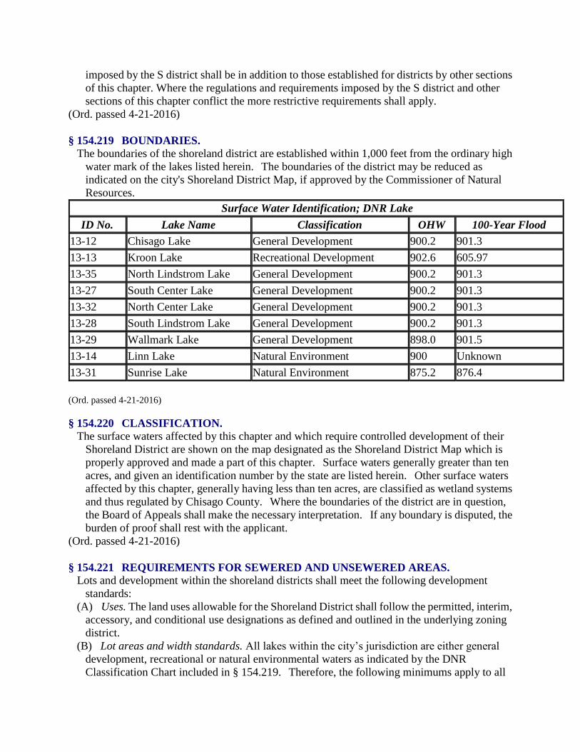
§ 154.219 BOUNDARIES.
The boundaries of the shoreland district are established within 1,000 feet from the ordinary high
water mark of the lakes listed herein. The boundaries of the district may be reduced as
indicated on the city's Shoreland District Map, if approved by the Commissioner of Natural
Resources.
Surface Water Identification; DNR Lake
ID No. Lake Name Classification OHW 100-Year Flood
13-12 Chisago Lake General Development 900.2 901.3
13-13 Kroon Lake Recreational Development 902.6 605.97
13-35 North Lindstrom Lake General Development 900.2 901.3
13-27 South Center Lake General Development 900.2 901.3
13-32 North Center Lake General Development 900.2 901.3
13-28 South Lindstrom Lake General Development 900.2 901.3
13-29 Wallmark Lake General Development 898.0 901.5
13-14 Linn Lake Natural Environment 900 Unknown
13-31 Sunrise Lake Natural Environment 875.2 876.4
(Ord. passed 4-21-2016)
§ 154.220 CLASSIFICATION.
The surface waters affected by this chapter and which require controlled development of their
Shoreland District are shown on the map designated as the Shoreland District Map which is
properly approved and made a part of this chapter. Surface waters generally greater than ten
acres, and given an identification number by the state are listed herein. Other surface waters
affected by this chapter, generally having less than ten acres, are classified as wetland systems
and thus regulated by Chisago County. Where the boundaries of the district are in question,
the Board of Appeals shall make the necessary interpretation. If any boundary is disputed, the
burden of proof shall rest with the applicant.
(Ord. passed 4-21-2016)
§ 154.221 REQUIREMENTS FOR SEWERED AND UNSEWERED AREAS.
Lots and development within the shoreland districts shall meet the following development
standards:
(A) Uses. The land uses allowable for the Shoreland District shall follow the permitted, interim,
accessory, and conditional use designations as defined and outlined in the underlying zoning
district.
(B) Lot areas and width standards. All lakes within the city’s jurisdiction are either general
development, recreational or natural environmental waters as indicated by the DNR
Classification Chart included in § 154.219. Therefore, the following minimums apply to all

lots within the Shoreland District.
Sewered Areas
Riparian Lots Non-Riparian Lots
Area Width Area Width
General Development:
Single 15,000 100 10,000 100
Duplex 26,000 135 17,500 135
Triplex 38,000 195 25,000 190
Quad+ 49,000 255 32,500 245
Recreational Development:
Single 20,000 100 15,000 100
Duplex 35,000 135 26,000 135
Triplex 50,000 195 38,000 190
Quad+ 65,000 255 49,000 245
Natural Environment:
Single 40,000 125 20,000 125
Duplex 70,000 225 35,000 220
Triplex 100,000 325 52,000 315
Quad+ 130,000 425 65,000 410
Unsewered Areas
Riparian Lots Non-Riparian Lots
Area Width Area Width
General Development:
Single 20,000 100 40,000 150
Duplex 40,000 180 80,000 265
Triplex 60,000 260 120,000 375
Quad+ 80,000 340 160,000 490
Recreational Development:
Single 40,000 150 40,000 150
Duplex 80,000 225 80,000 265
Triplex 120,000 300 120,000 375
Quad+ 160,000 375 160,000 490
Natural Environment:
Single 80,000 200 80,000 200
Duplex 120,000 300 160,000 400

Triplex 160,000 400 240,000 600
Quad+ 200,000 500 320,000 800
(C) Height. The maximum building structure height shall follow the individual district
requirements of the base zoning district.
(D) Placement of structures and sewage treatment systems on lots. When more than one
setback applies to a site, structures and facilities must be located to meet all setbacks.
(1) Buildings, including all structures such as decks but excluding one water oriented
accessory structure or facility, as permitted by § 154.221(D)(2)(f), must have a setback of
30 feet from the top of any bluff and a setback from the ordinary high water mark as
follows:
Setbacks (in feet) from Ordinary High Water Level
Structures
Class of Public Waters Unsewered Sewered Sewage Treatment System
Recreational Development Lake 100 75 75
General Development Lake 75 50 50
Natural Environmental Lake 150 150 150
(2) No structure or accessory facility, except stairways and landings, may be placed within
bluff impact zones. and nNo improvements may be made on steep slopes without a specific
land alteration permit that includes conditions issued by the city. The conditions shall be
structured to prevent erosion, preserve existing vegetation and screen the improvements and
vehicles for other facilities from the surface of public waters, assuming summer, leaf-on
vegetation.
(E) Setbacks from roads/right-of-ways. Any structure abutting a county or state highway must
meet the setback required by the controlling county or state authority for that parcel. Building
setback in residential districts shall be a minimum of 30 feet from state, Federal, or county
roads and city street right-of-ways.
(F) Design criteria for structures.
(1) High water elevations. Structures must be placed in accordance with all floodplain
regulations applicable to the site. Where these controls do not exist, the elevation to which the
lowest floor, including basement, is placed or flood-proofed must be determined as follows:
(a) The lowest floor shall be no lower in elevation than a level at least three feet above the
ordinary high water level of any riparian lake or the highest known elevation of any other
riparian water body.
(b) Water-oriented accessory structures may have the lowest floor placed lower than the
elevation determined in division (F)(1)(a) above, if the structure is constructed of
flood-resistant materials to the elevation, electrical and mechanical equipment is placed above
the elevation and, if long duration flooding is anticipated, the structure is built to withstand ice
action and wind driven waves and debris.
(2) Water oriented accessory structures. Each lot may have one water-oriented accessory

structure not meet normal structure setback set forth in this chapter providing the
water-oriented accessory structure complies with the following provisions:
(a) (a) The structure or facility shall not exceed ten feet in height, exclusive of safety rails
and cannot occupy an area greater than 250 square feet. , and The structure or facility may
include detached decks must not exceeding eight feet above grade at any point or at-grade
patios
(a)(b) The structure or facility is not in the Bluff Impact Zone.
(bc) The setback of the structure or facility from the ordinary high water level must be at
least ten feet.
(d) The structure is not a boathouse or a boat storage structure.
(cd) The structure or facility must be treated to reduce visibility as viewed from public
waters and adjacent shorelands by vegetation, topography, increased setbacks, color or other
means acceptable to the local unit of government, assuming summer, leaf-on conditions.
(de) Roofs of structures may be used as an open-air deck with safety rails, but must not be
enclosed or used as a storage area.
(ef) The structure or facility must not be designed or used for human habitation and must
not contain water supply or sewage treatment facilities.
(g) As an alternative for general development and recreational development waterbodies,
water-oriented accessory structures used solely for storage of watercraft and boating-related
equipment may occupy an area up to 400 square feet provided the maximum width of the
structure is 20 feet as measured parallel to the ordinary high water line
(fh) The owner or occupant of any riparian lot may have one fish house in addition to the
one water-oriented accessory structure allowed by the provisions of this division without
obtaining a variance. The fish house must display a current state fish house license issued to
that fish house in order to qualify for this exemption. Only one of the two structures may be
located in the shoreland impact zone.
(3) Stairways, lifts, and landings. Stairways and lifts are the preferred alternative to major
topographic alterations for achieving access up and down bluffs and steep slopes to shore
areas. Stairways and lifts must meet the following design requirements:
(a) Stairways and lifts must not exceed four feet in width on residential lots. Wider
stairways may be used for commercial properties, public open space recreational properties
and planned unit developments.
(b) Landings for stairways and lifts on residential lots must not exceed 32 square feet in
area. Landings larger than 32 square feet may be used for commercial properties, public
open-space recreational properties and planned unit developments.
(c) Canopies or roofs are not allowed on stairways, lifts or landings.
(d) Stairways, lifts and landings may be either constructed above the ground on posts or
pilings or placed into the ground, provided they are designed and built in a manner that ensures
control of soil erosion.
(e) Stairways, lifts and landings must be located in the most visually inconspicuous portions
of lots, as viewed from the surface of the public water assuming summer, leaf-on conditions,
whenever practical.
(f) Facilities such as ramps, lifts or mobility paths for physically disabled persons are also
allowed for achieving access to shore areas, provided that the dimensional and performance
standards of this section are met and the facilities comply with Minn. Rules Chapter 1341, as it
may be amended from time to time.

(4) Decks. Except as provided herein, decks must meet the structure setback
standards. Decks that do not meet setback requirements from public waters may be allowed
without a variance to be added to structures existing on the date the shoreland structure
setbacks were established by ordinance, if all of the following criteria and standards are met:
(a) A thorough evaluation of the property and structure reveals no reasonable location for a
deck meeting or exceeding the existing ordinary high water level setback of the structure;
(b) The deck encroachment toward the ordinary high water level does not exceed 15% of
the existing shoreline setback of the existing structure from the ordinary high water level or
does not encroach closer than 30 feet, whichever is more restrictive; and
(c) The deck is constructed primarily of wood and is not roofed or screened.
(5) Access lots. Access lots, which are intended as controlled accesses to public waters or
recreation areas for use by owners of nonriparian lots within subdivisions must meet or exceed
the following standards:
(a) They must meet the width and size requirements for residential lots and be suitable for
the intended uses of controlled access lots.
(b) They must be jointly owned by all purchasers of lots in the subdivision or by all
purchasers of nonriparian lots in the subdivision who are provided riparian access rights on the
access lot.
(c) Covenants or other equally effective legal instruments may be developed that specify
which lot owners have authority to use the access lot and what activities are allowed. The
activities may include watercraft launching, loading, beaching, mooring or docking. They may
also include other outdoor recreational activities that do not significantly conflict with general
public use of the public water or the enjoyment of normal property rights by adjacent property
owners. Examples of the non-significant conflict activities include swimming, sunbathing or
picnicking. The covenants may limit the total number of vehicles allowed to be parked and the
total number of watercraft allowed to be moored or docked and may require centralization of
all common facilities and activities in the most suitable locations on the lot to minimize
topographic and vegetation alterations. They may also require all parking areas, storage
buildings and other facilities to be screened by vegetation or topography as much as practical
from view from the public water, assuming summer, leaf-on conditions. In no case shall
covenant provisions be less restrictive than provisions of this section or any other city
ordinance.
(6) Placement, design, and heights of structures. When more than one setback applies to a
site, structures and facilities must be located to meet all setbacks. Where structures exist on the
adjoining lots on both sides of a proposed building site, structure setbacks may be altered
without a variance to conform to the adjoining setbacks from the ordinary high water level,
provided the proposed building site is not located in a shore impact zone or in a bluff impact
zone. Structures may not be located closer than 30 feet to the top of any bluff.
(7) Steep slopes. The Building Official must evaluate possible soil erosion impacts and
development visibility from public waters before issuing a permit for construction of sewage
treatment systems, roads, driveways, structures or other improvements on steep slopes. When
determined necessary, conditions must be attached to issued permits to prevent erosion,
significant viewscape impact, and to preserve existing vegetative screening from structures,
vehicles and other facilities as viewed to and from the surface of public waters, assuming
summer, leaf-on vegetation.
(8) Impervious surface. No lot shall be covered by more than 25% impervious surface. This

standard shall not apply for uses in the central business district, general business district or
industrial zones if the proposed use either causes no increase in surface water discharge or if all
discharges are accommodated by a surface water management system or program approved by
the city.
(G) Certification upon completion.
(1) Upon completion of any structure which was constructed or cited in a designated flood
hazard area, the permittee shall provide the Zoning Administrator with certification of the
as-built first floor elevation data and maintain an on-going record thereof.
(2) All A-zones as shown on the flood insurance rate map of the city are hereby designated as
the flood hazard areas of the city.
(Ord. passed 4-21-2016)
§ 154.222 WATER SUPPLY AND SEWAGE TREATMENT.
(A) Regulation required. In order to ensure safe and healthful conditions, to prevent pollution
and contamination of surface and ground water and to guide development compatible with the
natural characteristics of shorelands and related water resources, individual private water
supply and private waste treatment systems and all waste disposal systems and sites shall be
regulated by the provisions of this section and applicable state and Federal regulations.
(B) Permit required. No person, firm or corporation shall install, alter, repair or extend any
private well or sewage treatment system without first obtaining a permit from the City Zoning
Administrator for the specific installation, alteration, repair or extension.
(C) Water supply. Any public or private supply of water for domestic purposes must meet or
exceed standards for water quality of the State Department of Health and the State Pollution
Control Agency.
(D) Sewage treatment. Any premises used for human occupancy must be provided with an
adequate method of sewage treatment, as follows:
(1) The city sewer system must be used where available.
(2) All private sewage treatment systems must meet or exceed the latest Minnesota Pollution
Control Agency’s standards for individual sewage treatment systems. Individual Sewage
Treatment System Standards, Minn. Rules Chapter 7080, as it may be amended from time to
time, is hereby adopted by reference and declared to be a part of this chapter.
(3) On-site sewage treatment systems must be set back from the ordinary high water level of
any riparian waterbody in accordance with City Code § 154.221.
(4) (a) All proposed sites for individual sewage treatment systems shall be evaluated in
accordance with the evaluation criteria listed below.
(b) If the determination of a site’s suitability cannot be made with the publicly available
existing information, it shall then be the responsibility of the applicant to provide sufficient soil
borings and percolation tests from on-site field investigations.
1. Depth to the highest known or calculated ground water table or bedrock;
2. Soil conditions, properties and permeability;
3. Slope; and
4. Existence of lowlands, local surface depressions and rock outcrops.
(E) Nonconforming sanitary systems. All nonconforming water supply, sewage disposal and
waste disposal facilities and systems shall be brought into conformance with the provisions of
this section as a condition of receiving any permit, variance or approval required by state law
or local ordinance.
(Ord. passed 4-21-2016)
§ 154.223 SHORELAND ALTERATIONS.
(A) Vegetative alterations. Alterations of vegetation and topography must be controlled by
local governments to prevent erosion into public waters, fix nutrients, preserve shoreland
aesthetics, preserve historic values, prevent bank slumping and protect fish and wildlife
habitat.
(1) Exemptions. Vegetative alterations and excavations or grading and filling necessary for
the construction of structures and sewage treatment systems under validly issued permits for
these facilities are exempt from the vegetative alteration standards in this section and separate
permit requirements for grading and filling. However, the grading and filling conditions of this
subpart must be met for issuance of permits for structures and sewage treatment systems.
Public roads and parking areas, as regulated hereby are exempt from the provisions of this
subchapter.
(2) Removal or alterations of vegetation. Except for forest management or agricultural uses
as provided for herein, removal or alterations of vegetation is allowed according to the
following standards:
(a) Intensive vegetation clearing within the shore and bluff impact zones and on steep
slopes is not allowed. Intensive vegetation clearing outside of these areas is allowed if the
activity is consistent with the forest management standards herein.
(b) Limited clearing of trees and shrubs and cutting, pruning and trimming of trees to
accommodate the placement of stairways and landings, picnic areas, access paths, livestock
watering areas, beach and watercraft access areas and permitted water-oriented accessory
structures or facilities, as well as providing a view to the water from the principal dwelling site,
in shore and bluff impact zones and on steep slopes is allowed, provided that:
1. The screening of structures, vehicles or other facilities as viewed from the water,
assuming summer, leaf-on conditions, is not substantially reduced;
2. Along rivers, existing shading of water surfaces is preserved;
3. The above provisions are not applicable to the removal of trees, limbs or branches that
are dead, diseased or pose safety hazards; and
4. The city's tree preservation plan, City Code Chapter 157, must be followed.
(c) Use of fertilizer and pesticides in the shoreland management district must be done in a
way as to minimize runoff into the shore impact zone or public water by the use of earth,
vegetation or both.
(B) Grading or filling. Before grading or filling on steep slopes or within shore or bluff impact
zones involving the movement of more than ten cubic yards of material or anywhere else in a
shoreland area involving movement of more than 50 cubic yards of material, it must be
established by local official permit issuance that all of the following conditions will be
met. The following conditions must also be considered during subdivision, variance, building
permit and conditional use permit reviews.
(1) Before authorizing any grading or filling activity in any Type 2, 3, 4, 5, 6, 7 or 8 wetland,
local officials must consider how extensively the proposed activity would affect the following
functional qualities of the wetland:
(a) Sediment and pollutant trapping and retention;
(b) Storage of surface runoff to prevent or reduce flood damage;
(c) Fish and wildlife habitat;

(d) Recreational use;
(e) Shoreline or bank stabilization; or
(f) Noteworthiness, including special qualities such as historic significance, critical habitat
for endangered plants and animals or others.
(2) This evaluation must also include a determination of whether the wetland alteration being
proposed requires permits, reviews or approvals by other local, state or Federal agencies such
as a watershed district, Chisago County, Minnesota Department of Natural Resources or the
United States Army Corps of Engineers.
(3) Alterations must be designed and conducted in a manner that ensures only the smallest
amount of bare ground is exposed for the shortest time possible.
(4) Mulches or similar materials must be used, where necessary, for temporary bare soil
coverage and a permanent vegetation cover must be established as soon as possible.
(5) Methods to minimize soil erosion and to trap sediments before they reach any surface
water feature must be used.
(6) Areas must be stabilized to acceptable erosion control standards consistent with the field
office technical guides of the local soil and water conservation districts and the U.S. Soil
Conservation Service.
(7) Fill or excavated material must not be placed in a manner that creates an unstable slope.
(8) Plans to place fill or excavated material on steep slopes must be reviewed by qualified
professionals for continued slope stability and must not create finished slopes of 30% or
greater.
(9) Fill or excavated material must not be placed in bluff impact zones.
(10) Any alterations below the ordinary high water level of public waters must first be
authorized by the Minnesota Department of Natural Resources.
(11) Alterations of topography must only be allowed if they are accessory to permitted or
conditional uses and do not adversely affect adjacent or nearby properties.
(12) Placement of natural rock riprap, including associated grading of the shoreline and
placement of a filter blanket is permitted if the finished slope does not exceed three feet
horizontal to one foot vertical, the landward extent of the riprap is within ten feet of the
ordinary high water level, and the height of the riprap above the ordinary high water level does
not exceed three feet.
(13) All activity must also comply with City Code Chapter 151, Stormwater Management.
(C) Connections to public waters. Excavations where the intended purpose is connection to a
public water, such as boat slips, canals, lagoons and harbors, must be controlled by local
shoreland controls. Permission for excavations may be given only after the Minnesota
Department of Natural Resources has approved the proposed connection to public waters.
(Ord. passed 4-21-2016)
§ 154.224 ROADS, DRIVEWAYS AND PARKING AREAS.
Placement and design of roads, driveways, and parking areas. Public and private roads,
driveways and parking areas must be designed to take advantage of natural vegetation and
topography to achieve maximum screening from view from public waters. They must be
designed and constructed to minimize and control erosion to public waters consistent with the
field office technical guides of the local soil and water conservation district or other applicable
technical materials.
(A) Roads, driveways and parking areas must meet structure setbacks and must not be placed

within bluff and shore-impact zones, when other reasonable and feasible placement
alternatives exist. If no alternatives exist, they may be placed within these areas and must be
designed to minimize adverse impacts.
(B) Public and private watercraft access ramps, approach roads and access-related parking
areas may be placed within shore impact zones provided the vegetation, screenings and erosion
control conditions of this section are met. For private facilities, the grading and filling
provisions hereof must also be met.
(C) Paving permit required.
(1) Purpose. In order to facilitate this section, the city shall require an impervious surface
permit demonstrating that projects involving the installation of impervious materials are in
compliance with the provisions of the impervious surface requirements as stated in §
154.221(F)(8).
(2) Permit required. No person, firm, corporation, company or other entity (public or private)
shall cause the placement of asphalt, concrete or other impervious material within the city
without first obtaining a paving permit and/or all other required permits from the city and other
appropriate entities.
(3) Application. Unless otherwise regulated herein, any person, firm, corporation, company
or public entity shall fill out an application, provided by the city, for a permit to place
impervious materials for driveways, sidewalks, pathways, parking areas and other uses within
the city. The application shall be reviewed by the city. If the project is found to be in
compliance with the impervious surface requirements, the city may issue a permit allowing the
work to be accomplished.
(4) Liability. Any project approved should be constructed as to have minimal impact on
adjacent property. Efforts shall be taken to keep all runoff from the project area on the subject
property until it can outflow to a public drainageway.
(5) Fees. The fee for the application shall be set by motion of the City Council. For minor
projects, the fee may be waived.
(6) Projects not covered. A permit is not required for the normal care and maintenance of an
existing impervious surface so long as the square footage of the surface is not increased.
(D) Parking lots, excluding entrance/exit drives, may not be constructed closer than three feet
from the property line.
(Ord. passed 4-21-2016)
§ 154.225 DOCKS, LIFTS AND OTHER MOORING STRUCTURES OR FACILITIES.
Docks, lifts, other mooring structures or facilities, and marinas other than those owned or
operated by the state or a political subdivision, may be constructed or placed when allowed in
accordance with state law, other provisions of this code and the following provisions.
(A) Single-family lots. Docks, lifts, or other mooring structures located on single-family lots
(R-1 and R-1A) do not need a permit from the city, but must meet the following requirements:
(1) Only one dock, lift, or other mooring structure is permitted on each lot;
(2) Structures may be no wider than six feet, which shall be measured at the width of the
major running length of the dock;
(3) Docks shall be located so that moored watercraft and equipment are at least five feet from
the extended property line;

(4) Must not impede navigation or create a hazard;
(5) Mooring is limited to four restricted watercraft (of which no more than one may be
registered to other than a family member);
(6) Rental of slips is not allowed;
(7) Must be removed before freeze-up;
(8) In no cases shall easements be allowed for docks or mooring structures. Docks or mooring
facilities are allowed only on approved single-family lots;
(9) It is not the intent of this section to discontinue use of docks after they have been removed
for the winter. However, the landowner shall make every effort to comply with the
requirements of this section. In no case shall a landowner not be allowed to place his or her
dock back in the water (grandfather clause); and
(10) Except as modified by the above requirements, all other provisions of Minn. Rules Part
6115.0210, as may be amended from time to time, shall apply.
(B) Non single-family lots and PUDs.
(1) One dock, lift, or mooring structure may be located on lots other than single-family
residential lots and PUDs with a permit and subject to the following:

(a) Docks shall be located so that moored watercraft and equipment are at least five feet
from the extended property line;
(b) Must be no wider than six feet, which shall be measured at the width of the major
running length of the dock;
(c) Must not be used for more than six restricted watercrafts;
(d) Must not impede navigation or create a hazard;
(e) Must be removed before freeze-up. For extenuating circumstances or difficult terrain, a
dock may be moved as close to the lakeshore as possible. Any dock left in the water over the
winter must be marked with a reflective material and orange fence for visibility on each side.
The reflective material must measure a total of not less than nine square inches every six feet
on each side of the dock; and
(f) Except as modified by the above requirements, all other provisions of Minn. Rules Part
6115.0210, as may be amended from time to time, shall apply.
(2) Provided in divisions (B)(1)(a) through (f) above can be met, an applicant may apply for
an additional dock, lift, or mooring structures at the time of initial platting or subsequent to plat
approval. If owners apply for additional docks, lifts, or other mooring structures after initial

platting, the conditional use permit process outlined in this chapter shall apply. It is at the
discretion of the Planning Commission and City Council as to whether to approve additional
docks, lifts, or other mooring structures and they may place additional conditions on such
facilities as they deem appropriate.
(3) Marinas are allowed with a conditional use permit and Minnesota Department of Natural
Resources (DNR) Public Waters Permit and are subject to the requirements in division (B)(1)
above.
(4) Overnight beaching, docking, or continuous mooring of watercraft may be allowed with a
conditional use permit.
(5) In no cases shall easements be allowed for docks or other mooring structures.
(6) Except as modified by the above requirements, all provisions of Minn. Rules Part
6115.0210, as it may be amended from time to time, shall apply. Considerations of a
conditional use permit must include considerations of lot width, lot depth, land slope, water
depth, vegetation, soils, depth to ground water and bedrock, compatibility with adjacent land
uses and/or other relevant factors.
(7) It is not the intent of this section to discontinue use of docks after they have been removed
for the winter. However, the landowner shall make every effort to comply with the
requirements of this section. In no case shall a landowner not be allowed to place his or her
dock back in the water (grandfather clause).
(C) Commercial marinas. Commercial marinas shall be allowed in the CBD, B-1, B-2, and
Industrial Districts with a conditional use permit and subject to the following:
(1) Proof of a Minnesota Department of Natural Resources Public Waters Permit;
(2) Winter storage of slip rental customers and business owned boats will be allowed during
non-boating season only (typically from October 30 to April 30);
(3) Boats stored for the winter must be parked in an orderly fashion and covered with similar
covers;
(4) Docks must not impede navigation or create a hazard;
(5) Docks must be removed before freeze-up. For extenuating circumstances or difficult
terrain, a dock may be moved as close to the lakeshore as possible. Any dock left in the water
over the winter must be marked with a reflective material and orange fence for visibility on
each side. The reflective material must measure a total of no less than nine square inches every
six feet on each side of the dock; and
(6) Except as modified by the above requirements, all provisions of Minn. Rules Part
6115.0210, as may be amended from time to time, shall apply.
(Ord. passed 4-21-2016)
§ 154.226 AGRICULTURAL, FOREST AND EXTRACTIVE USES.
To the extent that these uses are allowed or permitted within shoreland areas, the following
standards or conditions apply for the particular use.
(A) Agriculture.
(1) The shore impact zone for parcels with permitted agricultural land uses is equal to a line
parallel to and 50 feet from the ordinary high water level.
(2) General cultivation farming, grazing, nurseries, horticulture, truck farming, sod farming
and wild crop harvesting, if allowed by this chapter, must be conducted in a manner to ensure
that steep slopes and shore and bluff impact zones are maintained in permanent vegetation or
operated under an approved conservation plan consistent with the field office technical guides

of the local soil and water conservation districts or the U.S. Soil Conservation Service.
(3) Animal feedlots, as defined by the State Pollution Control Agency, where allowed by
zoning district designations, must be reviewed as conditional uses and must meet the following
standards:
(a) New feedlots must not be located in the shoreland of watercourses or in bluff impact
zones and must meet a minimum setback of 300 feet from the ordinary high water level of all
public waters basins.
(b) Modifications or expansions to existing feedlots that are located within 300 feet of the
ordinary high water level or within a bluff impact zone are allowed if they do not further
encroach into the existing ordinary high water level setback or encroach on bluff impact zones.
(c) A certificate of compliance, interim permit or animal feedlot permit, when required by
state law, must be obtained by the owner or operator of an animal feedlot.
(4) Use of fertilizer, pesticides or animal wastes within shorelands must be done in a way as
to minimize impact on the shore impact zone or public water by proper application or use of
earth or vegetation.
(B) Forest management. The harvesting of timber and associated reforestation or conversion of
forested use to a non-forested use must be conducted consistent with the following standards:
(1) Timber harvesting and associated reforestation must be conducted consistent with the
provisions of the State Nonpoint Source Pollution Assessment Forestry and the provisions of
Water Quality in Forest Management Best Management Practices in Minnesota.
(2) To the extent permitted by this chapter or state law, forest land which is converted to
another use requires issuance of a conditional use permit and adherence to the following
standards:
(a) A shore and bluff impact zones must not be intensively cleared of vegetation; and
(b) An erosion and sediment control plan is developed and approved by the local soil and
water conservation district before issuance of a conditional use permit for the conversion.
(3) Use of fertilizer, pesticides or animal wastes within shorelands must be done in a way as
to minimize impact on the shore impact zone or public water by proper application or use of
earth or vegetation.
(C) Extractive uses. Processing machinery must be located consistent with setback standards
for structures from ordinary high water levels of public waters and from bluffs. An extractive
use site development and restoration plan must be developed and approved by the city, and
followed over the course of operation of the site. The plan must address dust, noise, possible
pollutant discharges, hours and duration of operation and anticipated vegetation and
topographic alterations. It must also identify actions to be taken during operation to mitigate
adverse environmental impacts, particularly erosion and must clearly explain how the site will
be rehabilitated after extractive activities end.
(Ord. passed 4-21-2016)
§ 154.227 COMMERCIAL, INDUSTRIAL, PUBLIC AND SEMI-PUBLIC USES.
(A) Surface water-oriented commercial uses and industrial, public or semipublic uses with
similar needs to have access to and use of public waters may be located on parcels or lots with
frontage on public waters. Uses without water-oriented needs must be located on lots or parcels
without public waters frontage or, if located on lots or parcels with public waters frontage,
must either be set back double the normal ordinary high water level setback or be substantially
screened from view from the water by vegetation or topography, assuming summer, leaf-on

conditions.
(B) Those with water-oriented needs must meet the following standards:
(1) In addition to meeting impervious coverage limits, setbacks and other zoning standards,
the uses must be designed to incorporate topographic and vegetative screening and parking
areas and structures.
(2) Uses that require short-term watercraft mooring for patrons must centralize these facilities
and design them to avoid obstructions of navigation and to be the minimum size necessary to
meet the need.
(3) Uses that depend on patrons arriving by watercraft may use signs and lighting to convey
needed information to the public, subject to the following general standards:
(a) No advertising signs or supporting facilities for signs may be placed in or upon public
waters. Signs conveying information or safety messages may be placed in or on public waters
by a public authority or under a permit issued by the County Sheriff.
(b) Signs may be placed, when necessary, within the shore impact zone if they are designed
and sized to be the minimum necessary to convey needed information. They must only convey
the location and name of the establishment and the general types of goods or services available.
The signs must not contain other detailed information such as product brands and prices, must
not be located higher than ten feet above the ground, and must not exceed 32 square feet in
size. If illuminated by artificial lights, the lights must be shielded or directed to prevent
illumination out across public waters.
(c) Other outside lighting may be located within the shore impact zone or over public
waters if it is used primarily to illuminate potential safety hazards and is shielded or otherwise
directed to prevent direct illumination out across public waters. This does not preclude use of
navigational lights.
(Ord. passed 4-21-2016)
§ 154.228 STORMWATER MANAGEMENT.
Stormwater management, as regulated by City Code Chapter 151 Stormwater Management,
must be considered with all reviews, approvals and permit issuances tendered under this
chapter.
(A) The following are general standards:
(1) When possible, existing natural drainage ways, wetlands and vegetated soil surfaces must
be used to convey, store, filter and retain stormwater runoff before discharge to public waters.
(2) Development must be planned and conducted in a manner that will minimize the extent of
disturbed areas, runoff velocities erosion potential and reduce and delay runoff
volumes. Disturbed areas must be stabilized and protected as soon as possible and facilities or
methods used to retain sediment on the site.
(3) When development density, topographic features and soil and vegetation conditions are
not sufficient to adequately handle stormwater runoff using natural features and vegetation,
various types of constructed facilities such as diversions, settling basins, skimming devices,
dikes, waterways and ponds may be used. Preference must be given to designs using surface
drainage, vegetation and infiltration rather than buried pipes and manmade materials and
facilities.
(B) The following are specific standards:
(1) Impervious surface coverage of lots must not exceed 25% of the lot area. This standard
shall not apply for uses in the central business district if the proposed use either causes no

surface water discharge or if all discharges are fully accommodated by a surface water
management system or program approved by the city.
(2) When constructed facilities are used for stormwater management, they must be designed
and installed consistent with the field office technical guide of the local soil and water
conservation districts.
(3) New construction of stormwater outfalls to public waters must provide for filtering or
settling of suspended solids and skimming of surface debris before discharge.
(Ord. passed 4-21-2016)
§ 154.229 SUBDIVISIONS.
In addition to Chapter 153 of this Code of Ordinances, all subdivisions and developments in the
shoreland areas of the city shall comply with the following provisions.
(A) Land suitability. Each lot created through subdivision must be suitable in its natural state
for the proposed use with minimal alteration. Suitability analysis by the city shall consider
susceptibility to flooding, existence of wetlands, soil and rock formations with severe
limitations for development, severe erosion potential, steep topography, inadequate water
supply or sewage treatment capabilities, near shore aquatic conditions unsuitable for
water-based recreation important fish and wildlife habitat, presence of significant historic sites
or any other feature of the natural land likely to be harmful to the health, safety or welfare of
future residents of the proposed subdivision or of the community.
(B) Platting. All subdivisions that create five or more lots or parcels that are two and one-half
acres or less in size must be platted in accordance with M.S. Chapter 505, as it may be
amended from time to time. No person may record parcels or receive building, sewage or
other permits for lots that are not part of an officially platted subdivision.
(C) Consistency with other controls. Subdivisions must conform to all other official controls
adopted by the city. In areas not served by publicly-owned sewer and water systems,
subdivisions may not be created unless domestic water supply is available and soil absorption
sewage treatment can be provided for every lot. A lot shall meet the minimum lot size and
must include at least a minimum contiguous lawn area, that is free of limiting factors (location
and type of water supply, soil type, depth to groundwater or impervious layer, slope, flooding
potential and other limiting factors), sufficient for the construction of two standard soil
treatment systems. Lots that would require use of holding tanks may not be approved.
(D) Information requirements. Developers must provide adequate information to make a
determination of land suitability. The information shall include at least the following:
(1) Topographic contours at ten-foot intervals or less from U.S. Geological Survey maps or
more accurate sources, showing limiting site characteristics;
(2) The surface water features required in M.S. Chapter 505, as it may be amended from time
to time, to be shown on plats, obtained from U.S. Geological Surveys quadrangle topographic
maps or more accurate sources;
(3) Adequate soils information to determine suitability for building and on-site sewage
treatment capabilities for every lot from the most current existing sources or from field
investigations such as soil borings, percolation tests or other methods;
(4) Information regarding adequacy of domestic water supply, extent of anticipated
vegetation and topographic alterations, near-shore aquatic conditions, including depths, (types
of bottom sediments and aquatic vegetation and proposed methods for controlling stormwater
runoff and erosion, both during and after construction activities);

(5) The location of 100-year flood plain areas from existing maps or data; and
(6) A line or contour representing the ordinary high water level, the “toe” and the “top” of the
bluffs, and the minimum building setback distances from the top of the bluff and the lake.
(E) Dedications. The developer shall provide, where required by the city, the fee transfer or
easement dedication for natural drainage or ponding areas for management of stormwater and
wetlands.
(F) Planned unit developments. Planned Unit Developments in the Shoreland District shall also
be regulated by the provisions of §§ 154.200 to 154.205.
(Ord. passed 4-21-2016)
§ 154.230 ADMINISTRATION AND ENFORCEMENT.
(A) The city shall administer and enforce shoreland management controls as provided in the
zoning ordinance.
(B) In addition to other standards and criteria for variances, conditional uses and
nonconformities provided in this chapter or state law, the city will apply the following criteria:
(1) Variances. Variances will only be granted in accordance with M.S. Chapter 462, as it may
be amended from time to time. They may not circumvent the general purposes and intent of
the official controls. No variance may be granted that would allow any use that is prohibited
in the zoning district in which the subject property is located. Conditions may be imposed in
the granting of variances to ensure compliance and to protect adjacent properties and the public
interest. In considering variance requests, the city must also consider whether property
owners have reasonable use of the lands without the variances, whether existing sewage
treatment systems on the properties need upgrading before additional development is
approved, whether the properties are used seasonally or year-round, whether variances are
being requested solely on the basis of economic considerations and the characteristics of
development on adjacent properties.
(2) Conditional uses. In addition to any existing standards the city has for reviewing
conditional uses, the following standards must be used for reviewing conditional uses located
in shoreland areas:
(a) A thorough evaluation of the topographic, vegetation and soils conditions on the site to
ensure:
1. Prevention of soil erosion or other possible pollution of public waters, both during and
after construction;
2. Limiting visibility of structures and other facilities as viewed from public waters; and
3. Adequacy of the site for water supply and on-site sewage treatment.
(b) An assessment of the types, uses and numbers of watercraft that the development or use
will generate in relation to the suitability of public waters to safely accommodate these
watercraft.
(c) The city may impose conditions when granting conditional use permits that specify
increased setbacks from public waters; vegetation allowed to be removed or required to be
established; sewage treatment system location; design; the use's location and design; and use
requirements for watercraft launching or docking, and for vehicular parking, structure or other
facility design, use and location; phasing of construction; and other conditions considered
necessary.
(3) Nonconformities.
(a) The city will require the upgrading or replacement of any existing, on-site sewage
treatment system identified as a nonconformity under a program established under state law as
Minn. Rules Part 6120.3400, as it may be amended from time to time. Systems installed
according to all applicable local shoreland management standards in effect at the time of
installation may be considered as conforming unless they are determined to be failing, except
that systems using cesspools, leaching pits, seepage pits or other deep disposal methods or
systems with less soil treatment area separation above groundwater than required by Minn.
Rules Chapter 7080, as it may be amended from time to time, shall be considered
nonconforming.
(b) All nonconformities other than on-site sewage treatment systems must be managed
according to applicable state statutes and local government official controls.
(Ord. passed 4-21-2016)