Licensed to BRITISH AIRWAYS PLC, . Printed from …uvairlines.com/admin/resources/charts/EKCH.pdfFor...
43
| JEPPESEN SANDERSON, INC., 2004. ALL RIGHTS RESERVED. .AIRPORT.BRIEFING. New page. 10-ABP-1 12 NOV 04 .Eff.25.Nov. CHANGES: EKCH/CPH JEPPESEN 122.75 122.85 D-ATIS Departure 1.2.1. GENERAL KASTRUP COPENHAGEN, DENMARK D-ATIS Arrival 1. GENERAL 1.1. ATIS 1.2. NOISE ABATEMENT PROCEDURES 1.2.2. PREFERENTIAL RUNWAY SYSTEM 1.2.2.1. RUNWAY RESTRICTIONS (BETWEEN 0600-2300LT) Propeller ACFT as well as turboprop ACFT with take-off weight of 11000 KGS or more and all jet ACFT should avoid overflying Greater Copenhagen (within KAS 15 DME) below 2500' (jet) or 1500' (prop). In case of special meteorological conditions (e.g. CB's significant wind variations) in the approach and take-off sectors, the ATC can at its discretion or on request from the Pilot-in-Command deviate from the restrictions stated below. Propeller & turboprop ACFT with take-off weight of 11000 KGS or more and all jets: RWYs 04L/R and 22L/R are the preferential RWYs and shall be used for take-off and landing to the greatest possible extent. When RWY 04L/R is in use, RWY 04R shall be used for take-off and RWY 04L for landing unless one of the RWYs can not be used due to snow clearance, disabled ACFT, work on the RWY or RWY conditions. However, ATC can make use of parallel operations when regard of capacity makes it necessary. Depending on the time of operation, certain types of ACFT are due to their noise characteristics only allowed to take-off from RWY 04R and land on RWY 04L. When RWY 22L/R is in use between 0700-2200LT, RWY 22R shall be used for take-off and RWY 22L for landing unless one of the RWYs can not be used due to snow clearance, disabled ACFT, work on the RWY or RWY conditions. However, ATC can make use of parallel operations when regard of capacity makes it necessary. Depending on the time of operation, certain types of ACFT are due to their noise characteristics only allowed to take-off from RWY 22R and land on RWY 22L. When RWY 22L/R is in use between 2200-2300LT and 0600-0700LT, RWY 22L shall be used for take-off and landing. RWY 22R may, however, be used between 2200-2300LT and 0600-0700LT when: - RWY 22L is used for ILS CAT II & III approaches; - RWY 22L can not be used for take-off due to snow clearance, disabled ACFT, work on the RWY or RWY conditions; - an extraordinary traffic situation causes delays of more than 1 hour; - regard of capacity makes it necessary to use parallel operations on RWY 22L/R. Certain types of ACFT are, due to their noise characteristics, only allowed to use RWY 22L. RWYs 12 & 30 may be used when: - the crosswind component on the preferential RWYs exceeds 15 KT. - the friction coefficient is below 0.3 on any part of the preferential RWYs. - the meteorological conditions are below minima for landing on the preferential RWYs. - the preferential RWYs can not be used due to snow clearance, disabled ACFT, work on the RWYs or TWYs or due to RWY conditions. When wind conditions permit so, RWY 12 shall be used for take-off in preference to RWY 30. RWY 30 may, however, be used for landing without restrictions. If a preferential RWY is RWY in use irrespective that the crosswind component exceeds 15 KT, a request to use RWY 12 or RWY 30 will be complied with. If a preferential RWY is not RWY in use due to the crosswind component exceeding 15 KT, a request to use a preferential RWY will be complied with if the handling of the other traffic so permits. A request for permission to deviate from a clearance will be complied with if the Pilot-in-Command claims safety reasons. Licensed to BRITISH AIRWAYS PLC, . Printed from JeppView disc 04-05. Notice: After 17.3.2005 0901Z this chart should not be used without first checking JeppView or NOTAMs.
Transcript of Licensed to BRITISH AIRWAYS PLC, . Printed from …uvairlines.com/admin/resources/charts/EKCH.pdfFor...
| JEPPESEN SANDERSON, INC., 2004. ALL RIGHTS RESERVED.
.AIRPORT.BRIEFING.
New page.
10-ABP-112 NOV 04.Eff.25.Nov.
CHANGES:
EKCH/CPH JEPPESEN
122.75122.85D-ATIS Departure
1.2.1. GENERAL
KASTRUPCOPENHAGEN, DENMARK
D-ATIS Arrival
1. GENERAL
1.1. ATIS
1.2. NOISE ABATEMENT PROCEDURES
1.2.2. PREFERENTIAL RUNWAY SYSTEM
1.2.2.1. RUNWAY RESTRICTIONS (BETWEEN 0600-2300LT)
Propeller ACFT as well as turboprop ACFT with take-off weight of 11000 KGS or more and all jet ACFT should avoid overflying Greater Copenhagen (within KAS 15 DME) below 2500' (jet) or 1500' (prop). In case of special meteorological conditions (e.g. CB's significant wind variations) in the approach and take-off sectors, the ATC can at its discretion or on request from the Pilot-in-Command deviate from the restrictions statedbelow.
Propeller & turboprop ACFT with take-off weight of 11000 KGS or more and all jets:RWYs 04L/R and 22L/R are the preferential RWYs and shall be used for take-off and landing to the greatest possible extent.When RWY 04L/R is in use, RWY 04R shall be used for take-off and RWY 04L for landing unless one of the RWYs can not be used due to snow clearance, disabled ACFT, work on the RWY or RWY conditions. However, ATC can make use of parallel operations when regard of capacity makes it necessary. Depending on the time of operation, certain types of ACFT are due to their noise characteristics only allowed to take-off from RWY 04R and land on RWY 04L.When RWY 22L/R is in use between 0700-2200LT, RWY 22R shall be used fortake-off and RWY 22L for landing unless one of the RWYs can not be used due to snow clearance, disabled ACFT, work on the RWY or RWY conditions. However, ATC can make use of parallel operations when regard of capacity makes it necessary. Depending on the time of operation, certain types of ACFT are due to their noise characteristics only allowed to take-off from RWY 22R and land on RWY 22L.When RWY 22L/R is in use between 2200-2300LT and 0600-0700LT, RWY 22L shallbe used for take-off and landing.RWY 22R may, however, be used between 2200-2300LT and 0600-0700LT when:- RWY 22L is used for ILS CAT II & III approaches;- RWY 22L can not be used for take-off due to snow clearance, disabled ACFT, work on the RWY or RWY conditions;- an extraordinary traffic situation causes delays of more than 1 hour;- regard of capacity makes it necessary to use parallel operations on RWY 22L/R. Certain types of ACFT are, due to their noise characteristics, only allowed to use RWY 22L.RWYs 12 & 30 may be used when:- the crosswind component on the preferential RWYs exceeds 15 KT.- the friction coefficient is below 0.3 on any part of the preferential RWYs.- the meteorological conditions are below minima for landing on the preferential RWYs.- the preferential RWYs can not be used due to snow clearance, disabled ACFT, work on the RWYs or TWYs or due to RWY conditions.When wind conditions permit so, RWY 12 shall be used for take-off in preferenceto RWY 30.RWY 30 may, however, be used for landing without restrictions.If a preferential RWY is RWY in use irrespective that the crosswind component exceeds 15 KT, a request to use RWY 12 or RWY 30 will be complied with.If a preferential RWY is not RWY in use due to the crosswind component exceeding 15 KT, a request to use a preferential RWY will be complied with if the handling of the other traffic so permits.A request for permission to deviate from a clearance will be complied with if the Pilot-in-Command claims safety reasons.
Licensed to BRITISH AIRWAYS PLC, . Printed from JeppView disc 04-05.
Notice: After 17.3.2005 0901Z this chart should not be used without first checking JeppView or NOTAMs.
| JEPPESEN SANDERSON, INC., 2004. ALL RIGHTS RESERVED.
.AIRPORT.BRIEFING.
New page.
10-ABP-212 NOV 04.Eff.25.Nov.
CHANGES:
EKCH/CPH JEPPESEN
KASTRUPCOPENHAGEN, DENMARK
1. GENERAL
1.2.2.2. RUNWAY RESTRICTIONS (BETWEEN 2300-0600LT)
1.2.3. NIGHTTIME RESTRICTIONS
Propeller & turboprop ACFT with take-off weight of 11000 KGS or more and all jets:When RWY 22L/R is in use, RWY 22L shall be used for take-off and landing.RWY 22R may, however, be used when:- RWY 22L is used for CAT II & III approaches.- RWY 22L can not be used for take-off due to snow clearance, disabled ACFT, work on the RWY or RWY conditions.- an extraordinary traffic situation causes delays of more than 1 hour.All ACFT:RWYs 12 and 30 are closed for take-off and landing.RWY 30 may, however, be used for landings when:- the crosswind component on the preferential RWYs exceeds 15 KT;- the preferential RWYs can not be used due to snow clearance, disabled ACFT, work on the RWYs etc.Furthermore RWYs 12 and 30 may, however, be used in the following cases:- for take-off and landing by vital flights such as ambulance and transplantation flights if the preferential RWYs are not available.- for alternate landings, when the preferential RWYs are no longer available after the flight has commenced and the use of any other alternate APT is not possible.- for landing in such cases where the aeroplane during flight has experienced reduced airworthiness and the Pilot-in-Command judges it necessary to land; - for landings when the Pilot-in-Command declares an emergency situation.The Pilot-in-Command shall as soon as possible submit a written report to the Civil Aviation Administration stating the reasons for using RWY 12/30. The Civil Aviation Administration will make further investigation based on the reports from the Pilot-in-Command and the ATC.
All ACFT:- Between 2300-0600LT take-off and landings shall be arranged in such a way that the maximum A-weighted sound pressure level does not exceed 85 dB (80 dB from Jan 1st 2005) in six Noise monitoring point positions (1, 5, 6, 7, 8, 9) in the surrounding residential areas. Exempted are: - delayed flights with scheduled take-off or landing before 2300LT. - early arriving flights with scheduled landing after 0600LT. Violations of the maximum A-weighted sound pressure level will be accepted if caused by: - flight safety conditions. - RWY utilization due to work on the RWY, CAT II and III landings and other special weather conditions. - meteorological conditions which according to an evaluation by the Civil Aviation Administration has influenced the sound transmission.- Take-off requires an advance approval of the Kobenhavns Lufthavne A/S (Copenhagen APTs) between 2300-0600LT. An advance approval may be obtained for a period of about six months if the ACFT used is noise certificated in accordance with ICAO Annex 16, Chapters 2, 3 or 5, or if the applicant has demonstrated that the take-off can be carried out in such a way that the demands stated above are complied with. If no advance approval exists take-off may take place (for jets or ACFT with take-off weight of 11000 KGS or more only as an exception) if the operator obtains a permit by the APT Office either based on documentation stating that the ACFT is noise certificated or based on the knowledge of the Kobenhavns Lufthavne A/S (Copenhagen APTs) that corresponding ACFT have the ability to comply with demands stated above.- Between 2300-0100LT no advance approval is required if the take-off takes place in the said interval as a result of delay.- For landing no advance approval is required.
Licensed to BRITISH AIRWAYS PLC, . Printed from JeppView disc 04-05.
Notice: After 17.3.2005 0901Z this chart should not be used without first checking JeppView or NOTAMs.

| JEPPESEN SANDERSON, INC., 2004. ALL RIGHTS RESERVED.
.AIRPORT.BRIEFING.
New page.
10-ABP-312 NOV 04.Eff.25.Nov.
CHANGES:
EKCH/CPH JEPPESEN
KASTRUPCOPENHAGEN, DENMARK
1. GENERAL
1.3. TAXI PROCEDURES
1.4. PARKING INFORMATION
Stands G110 and G111 available for helicopters.
1.4.1. USE OF APU
ACFT must not perform powered U-turns on TWYs in the apron areas.In the apron areas minimum engine power shall be used as far as possible, anduse of reverse thrust for manoeuvring to and from stands is not permitted.TWYs A3, A4, G4, G5, K1 and N1 are not to be used by ACFT larger than code C.When TWYs A1 and A2 are used by ACFT code D, E or F, traffic behind mentionedACFT may not take place with ACFT larger than code C (except Dash 8-400).TWY A2 shall not be used by ACFT larger than code C (except Dash 8-400) when an ACFT is on final approach RWY 22R.Towing is mandatory when moving jet ACFT between the northern part of theAPT and Area South.Only when taxiing to or from RWY in use code B and C jet ACFT are allowed totaxi under own power on TWYs N1, N2 and on southern end of TWY C. TWY N2 is to be used by towing only for ACFT larger than code C (except Dash 8-400).ACFT larger than code C (except Dash 8-400) taxiing on TWY Z must not pass behind ACFT holding at the stopbars on TWYs A, B, D, F or K3.Taxiing on TWY W is limited to MAX 10 KT for ACFT code E. Marshaller assistance is compulsory, after instruction from ATC, for general aviation ACFTs during taxiing. Marshaller assistance/follow-me car are available on request only exceptwhen compulsory for the relevant stand. ACFT movements must never coincide on adjacent ACFT stands with overlappingsafety lines. ACFT must not simultaneously taxi into and/or taxi out/push-backfrom any two adjacent stands.Taxi-out or push-back from ACFT stands must not be executed without approvalfrom KASTRUP Ground. For Taxi Routings refer to 10-9 charts.
1.3.1. APRON NORTHAt stands F90 thru F98 daily 2300-0600LT (F27: 2200-0700LT): Main enginesare not to be used. At 2200-0700LT jet ACFT operations under own power are not allowed.ACFT on parking area E60 engines must be used only up to 2 min prior to departure.
1.3.2. APRON WESTRefuelling on stands RI, RII and RIII is prohibited.
Insufficient safety clearance may prevent large ACFT from using certain TWYs.Taxi routings given by KASTRUP Tower/KASTRUP Apron must be strictly adhered to.
1.3.3. TAXI LIMITATIONS FOR JET ACFT
The use of APU shall be limited as much as possible. APU may be used:- 5 minutes after 'on block';- 5 minutes before ETD.Exemptions:When outside air temperature is below -10^C or above +25^C, or the APT supply ofpower/airconditioning is unserviceable, ACFT types larger than ICAO code letter C, are allowed to use APU as follows: - 10 minutes after 'on block';- 45 minutes before ETD. All other types:- 5 minutes after 'on block';- 15 minutes before ETD.
Licensed to BRITISH AIRWAYS PLC, . Printed from JeppView disc 04-05.
Notice: After 17.3.2005 0901Z this chart should not be used without first checking JeppView or NOTAMs.

| JEPPESEN SANDERSON, INC., 2004. ALL RIGHTS RESERVED.
.AIRPORT.BRIEFING.
New page.
10-ABP-412 NOV 04.Eff.25.Nov.
CHANGES:
EKCH/CPH JEPPESEN
KASTRUPCOPENHAGEN, DENMARK
1.5. OTHER INFORMATION
Ships up to 115' may obstruct. ACFT will be informed about ships with height of more than 115' before T/O on RWYs 04R and 12.
1. GENERAL
2. ARRIVAL
2.1. NOISE ABATEMENT PROCEDURES
2.1.1. LANDING RESTRICTIONS
2.1.2. REVERSE THRUSTUse of more than idle reverse thrust is allowed only for safety reasons. With respect to propeller & turboprop ACFT idle reverse refers to propeller in beta range and engine at idle power.
2.2. CAT II/III OPERATIONS
RWY 04L is approved for CAT II operations, RWY 22L is approved for CAT II/III operations; special aircrew and ACFT certificaton required. Pilots who intend to carry out a CAT II/III ILS approach are to use the following phrase:"Request Category II (or III) ILS approach RWY ... (mention RWY number)".Above mentioned request shall be made to either MALMO Control or to COPENHAGEN Control and confirmed on first contact with COPENHAGEN Approach.Vacated RWY reports must not be given before established on:- TWY A when landing RWY 04L- TWY B when landing RWY 22LDuring CAT III vacate via TWY B1, B3 or B4 only.
2.3. TAXI PROCEDURES
2.5. OTHER INFORMATION
Propeller & turboprop ACFT with take-off weight of 11000 KGS or more and all jets:- RWY 04L/R: Visual approaches must be performed within the sector shown on chart 10-4. Visual approaches crossing the sector boundaries will be investigated by the authorities.- RWY 12: During instrument approach as well as visual approach, flying below the ILS glide path angle is not allowed.
Multi-engine propeller ACFT shall enter stand with one engine operating only. Code D and E ACFT must enter stand B10 via TWYs Z and M.Taxiing onto stands B10, B15 and B17 is with follow-me vehicle while crossingthe service road.Between 2200-0500LT ACFT bound for stands A30 thru A34 must be towed ontothe stand.Arriving ACFT must stop at the NIGHT STOP position on TWY V.For Taxi Routings refer to 10-9 charts.
2.4. PARKING INFORMATION
For Stand graphic refer to 10-9 charts.
DEPENDENT PARALLEL APPROACHES RWYS 04L/22R AND 04R/22L:Decision concerning applicable RWY will be passed by Approach Control to ACFT not later than on intermediate approach. Expect dependent parallel operations between 0500-2200LT if VIS is 800m or more. RWYs 04L and 22Lcan be expected, or as directed.Expect radar vectoring for ILS approaches. RWYs closed for landing for following ACFT:- RWY 04L: AN124, AN225, KC10, C5 GALAXY.- RWY 12: AN225, B777-300, A340-500/-600.- RWY 22R: AN124, AN225, KC10, C5 GALAXY, B777-300, A340-500/-600.- RWY 30: AN225.
Licensed to BRITISH AIRWAYS PLC, . Printed from JeppView disc 04-05.
Notice: After 17.3.2005 0901Z this chart should not be used without first checking JeppView or NOTAMs.
| JEPPESEN SANDERSON, INC., 2004. ALL RIGHTS RESERVED.
.AIRPORT.BRIEFING.
New page.
10-ABP-512 NOV 04.Eff.25.Nov.
CHANGES:
EKCH/CPH JEPPESEN
KASTRUPCOPENHAGEN, DENMARK
3. DEPARTURE
3.1. DE-ICING
3.2. START-UP, PUSH-BACK & TAXI PROCEDURES
Request for de-icing must be put forward to KASTRUP Ground by pilot-in-command at latest at the same time as request for push-back/start-up approvalis made. When parked turn-in/turn-out, pilots need to request de-icing before start-up and request for taxi-out. Advice on which de-icing platform to taxi to is then given when KASTRUP Ground issues taxi-clearance. Additionally a queue number for the platform will be issued. Some waiting time may be expected in the period 0000-0600LT. All ACFT taxi to platform under own power, and will be de- or anti-iced with their engines operating. Platform TWY A can be used by ICAO code A-C ACFT types.Platform TWY B can be used by ICAO code A-E ACFT types.Platform TWY V can be used by ICAO code A-D ACFT types. The appropriate frequencies for de-icing communication are:TWY A: 130.65 123.4TWY B: 131.65TWY V: 131.6Ground personnel on the site arrange with pilot-in-command details of the actual de- or anti-icing operation. All ACFT types taxi in and stop at the yellow "WAIT" marking on the surface.When the platform is vacated, next waiting ACFT moves slowly forward onto the platform, using the traffic signal for guidance on where to stop correctly.Platform TWY A shows yellow stop markings. The traffic signal on platform TWY B shows flashing green light for permission to taxi ahead, flashing amber light (CAUTION) and finally steady red light for proper stop at blue marking "STOP MAIN GEAR" on surface.Platform TWY V is equipped with INOGON-displays and stop marking on ground for stopping the ACFT.Pilots must await ALL CLEAR SIGNAL (thumb up) before moving.The platforms are covered by a special friction surface, but still the braking action may be reduced due to de-icing fluid.After de-icing, all ACFT must move forward to the relevant stop bar.ACFT must request and await taxi clearance from KASTRUP Ground (platforms TWY B and TWY V), from KASTRUP Tower (platform TWY A).
Departing ACFT shall obtain push-back/start-up approval and taxi instructions from KASTRUP Ground, except for ACFT from Apron East andArea South - they are requested to call KASTRUP Tower.Engine start-up of ACFT larger than code C (except Dash 8-400) is at designated start-up positions on the TWYs only.JET ACFT:On nose-in/push-back stands, jet engine start-up must take place afterpush-back has been initiated only, unless APU is unserviceable or ACFT isnot fitted with APU. However, Code D and E ACFT (except Dash 8-400) are not allowed to perform engine start-up until after the ACFT has been towed onto its assigned start-up position on the apron.For simultaneous push-backs directions will be given by KASTRUP Ground.PROPELLER ACFT:During start-up of multi-engine propeller ACFT noise should be reduced as much as possible.- On nose-in/push-back stands, one engine only must be started on the stand. Start-up of remaining engines after push-back.- On turn-in/turn-out stands one engine only should be started on the stand. ACFT pushing back from stands A4, A6, A8, A18 thru A22 and B2 must notstart the engines until the ACFT is placed at a designated start-up position onthe TWY, properly aligned with the centerline. Between 2200-0500LT ACFT departing stands A30 thru A34 must not start upengines until the ACFT is placed at position Z4. Departing ACFT have to be towed to the NIGHT STOP position on TWY V beforethe main engines may be started. For Taxi Routings refer to 10-9 charts.
Licensed to BRITISH AIRWAYS PLC, . Printed from JeppView disc 04-05.
Notice: After 17.3.2005 0901Z this chart should not be used without first checking JeppView or NOTAMs.

| JEPPESEN SANDERSON, INC., 2004. ALL RIGHTS RESERVED.
.AIRPORT.BRIEFING.
New page.
10-ABP-612 NOV 04.Eff.25.Nov.
CHANGES:
EKCH/CPH JEPPESEN
KASTRUPCOPENHAGEN, DENMARK
3. DEPARTURE
3.3. SPEED RESTRICTIONS
MAX 250 KT at or below FL 70.
3.4. NOISE ABATEMENT PROCEDURES
3.5. OTHER INFORMATION
RWYs closed for t/o for following ACFT:- RWY 04L: AN124, AN225, KC10, C5 GALAXY, B777-300, A340-500/-600.- RWY 12: AN225, B777-300, A340-500/-600.- RWY 22R: AN124, AN225, KC10, C5 GALAXY, B777-300, A340-500/-600.- RWY 30: AN225, B777-300, A340-500/-600.
TAKE-OFF RESTRICTIONSDepartures crossing the sector boundaries shown on chart 10-4 will be investigated by the authorities. Propeller & turboprop ACFT with take-off weight less than 11000 KGS between 2300-0600LT:- RWY 22L: Turn must not be commenced until having passed KAS 2 DME (LARSO).- RWY 22R: Turn must not be commenced until having passed KAS 2 DME (RUBAT). Propeller & turboprop ACFT with take-off weight of 11000 KGS or more and all jets:- RWY 22L: Take-off shall be carried out from position V1 or V2/1. Turn must not be commenced until having passed KAS 2 DME (LARSO).- RWY 22R: Turn must not be commenced until having passed KAS 2 DME (RUBAT).- RWY 12: Position K1/F1 must not be used for take-off. Take-off for jet ACFT shall be carried out from position K3, additionally the following apply: - ACFT types A330-200/-300, A340-200/-300, B747 (all versions), B767-400, B777-200, DC10 (all versions), IL86, IL96-300, L1011 (all versions) and MD11 shall take-off from a position adjacent to position K3 and taxi via K2 or via F2 and F1; - ACFT types A340-500/-600, AN124, AN225, B777-300 and C5/L500 Galaxy shall take-off from a position adjacent to position K3 and taxi via F2 and F1. Take-off for propeller & turboprop ACFT from position K2 or K3. However, ACFT type AN22 shall taxi via K2 or F2 or F1. Turns must not be commenced until having passed KAS R-078.- RWY 30: Take-off shall be commenced from position G1. Jet ACFT must arrange take-off in such a way, that maximum sound pressure level at Noise monitoring point No.10 (approx. 1.9 NM/3.5 KM from the beginning of RWY 30) does not exceed 110 PNdB. Turns must not be commenced until having passed KAS R-358.If take-off is planned from RWY 04L/R, 22L/R or RWY 12 from position K2 or K3 and can not be carried out (due to changes in weather or RWY conditions occurring not more than 1 hour prior planned take-off time) take-off is allowed on:- RWY 12 from position 12-X or K2 between 0600-2300LT;- RWY 30 between 0700-2200LT irrespective that the maximum sound pressure level exceeds 110 PNdb at Noise monitoring point No.10.
Licensed to BRITISH AIRWAYS PLC, . Printed from JeppView disc 04-05.
Notice: After 17.3.2005 0901Z this chart should not be used without first checking JeppView or NOTAMs.

D
D
D
DD35.1
D31.6
FL150
MAX
LU
GA
SMAX
FL110
RO
SBI
MAX
FL120
210^
1A, 1C
073^
R253
^
LUGAS
2A,
3B
034^
NEKSO
N55
13.9
E012
39.0
032^
VENO
MN55
29.1
E013
07.8
3A, 3
C
285^
15
104^
R284^
074^
091^
170^ 1B, 1D
059^
KUBIS
N55
13.4
E012
28.9 013
^
3B, 3D
255^
13
059^
VEG
UD
N55
21.8
E013
12.0
2C,
3D
ROSBI
2B,
2D
RO
SBI 2
Z
RO
SBI 2
A,
2C
LUGAS
2A, 2
C
MHA 3
500
MAX F
L300
CD
A
114^
LUGAS 3
B
LUGAS 3
D
310^
18
DESA
SN55
36.8
E013
09.6
MAX
FL280
5000
MO
NA
KN54
56.7
E012
18.8
R212^
032^
4
24
11.1
(115
.5 O
DN
R-1
43)
13.5
18.1
HO
LDIN
GS O
VER
MAX F
L300
MHA 3
500
283^
103^
EKCH/CPHKASTRUP
COPENHAGEN, DENMARK
Apt Elev
17'122.75D-ATIS
.STAR.
1.Alt Set: hPa Trans level: By ATC Trans alt: 5000'
10-2
RO
SBI
CDA
CODAN
114.9
CDA
CD
AN55
00.1
E012
22.8
D
FL1
20
TRANO
117.4
TNO
TNO
N55
46.4
E011
26.4
D
FL1
20
At
or b
elow
SVED
A11
6.2
SVD
SVD
N56
10.1
E012
34.4
D
FL1
10
At
or b
elow
ALM
A11
6.4
ALM
ALM
N55
24.7
E013
33.5
ALM
3A,
3C
ALM
2D
ALM
3B
KAST
RUP
112.5
KAS
KAS
N55
35.4
E012
36.8
D
KORS
A11
2.8
KOR
KO
RN55
26.4
E011
37.9
D
At
or b
elow
LUG
AS
3D
FL8
0
At
or b
elow
FL1
10
At
or b
elow
FL1
10
LUG
AS
2A,
3B,
2C
ROSBI
2A,
2B,
2C,
2D,
2Z
SVD
SVD
At first contact with APPROACH, state type of aircraft. 2. At initialcontact with FINAL, state only callsign. 3.will be via holding pattern ALM, CDA, LUGAS, ROSBI or SVD. 4. Trafficshall flight plan via the appropriate primary holding pattern. 5. Radarvectoring will be provided.
16.7
13.8
CDA
CDA
| JEPPESEN SANDERSON, INC., 2003, 2005. ALL RIGHTS RESERVED.
(115
.5 O
DN
R-0
29) 2
4
TNO t
o a
ll R
wys
KOR t
o R
wy 3
0MAX
FL80
All t
raff
ic: MONAK
KOR t
o R
wys
04L/R, 12, 22L/R
Tra
ffic
flightp
lanned
via
GES:
25 N
M p
rior
GES
If traffic demands, clearance
1
1Level re
str
iction m
ust
be c
omplied w
ith. If
unable
to
comply
advis
e A
TC a
s s
oon a
s p
ossib
le.
6.
Level restrictions; restriction in chart heading.
Do not descend until cleared by ATC.
FL70
MSA
189^
074^
309^
1500
'
1700
'21
00'
KA
S VO
R
NO
T TO
SCA
LE
Posit
ion
Level
restric
tio
n
LUG
AS
N55
19.8
E010
57.8
RO
SBI
N55
53.9
E010
31.9
N55
16.6
E010
38.9
114^
294^
TESPI
TUDLO
179^
359^
113.5
GES
GED
SER
N54
37.1
E011
56.0
GES
MAX FL2
00231^
051^
MHA 3
500
CHANGES:
JEPPESEN
FOR COPENHAGEN/KASTRUPLEVEL RESTRICTIONSPRIMARY HOLDINGS &
N55
51.0
E010
55.9
ST
AR f
rom
25 FEB 05
Licensed to BRITISH AIRWAYS PLC, . Printed from JeppView disc 04-05.
Notice: After 17.3.2005 0901Z this chart should not be used without first checking JeppView or NOTAMs.
D
D
DEK
(R)-
17EK
(R)-
18
249^
210^
073^
R253
^
LUGAS
2A,
2C
034^
NEKSO
N55
13.9
E012
39.0
032^
VENO
M
285^
15
104^
R284^
ROSBI
2A,
2C,
2Z
074^
091^
1
1
1
1
1
1RO
SBI 2
Z
RO
SBI 2
A,
2C
18.1
EKCH/CPHKASTRUP
COPENHAGEN, DENMARK
Apt Elev
17'122.75D-ATIS
10-2A .STAR.
1. 2.Alt Set: hPa Trans level: By ATC Trans alt: 5000'
1
RO
SBI
N55
51.0
E010
55.9
KORS
A11
2.8
KOR
KO
RN55
26.4
E011
37.9
D
MAX 2
50 K
T
CODAN
114.9
CDA
CD
AN55
00.1
E012
22.8
D
LUG
AS
N55
19.8
E010
57.8
KAST
RUP
112.5
KAS
KAS
N55
35.4
E012
36.8
D
FL1
10
At
or b
elow
At
or b
elow
At
or b
elow
CD
A 3
A
CD
A 3
C
FL1
00
16.7 CDA 3A
, 3C
At
or b
elow
CD
A 3
A
FL8
0ALM
A11
6.4
ALM
ALM
N55
24.7
E013
33.5
D
N55
29.1
E013
07.8
D18.7
KA
S
ALM
3A,
3C
SVED
A11
6.2
SVD
SVD
N56
10.1
E012
34.4
D
FL1
10
At
or b
elow
SVD 1A, 1C
FL1
20
TRANO
117.4
TNO
TNO
N55
46.4
E011
26.4
D
FL1
20
At
or b
elow
24
At first contact with APPROACH, state type of aircraft. At initialcontact with FINAL, state only callsign. 3.by ATC.
Restriction in chart heading. | JEPPESEN SANDERSON, INC., 2003, 2005. ALL RIGHTS RESERVED.
Do not descend until cleared
ROSBI 2Z
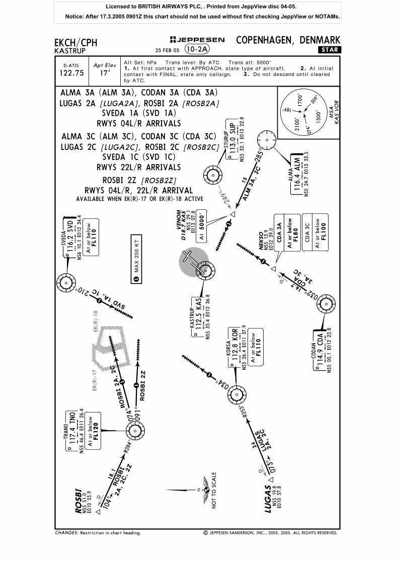
SVEDA 1A (SVD 1A)ROSBI 2A
ALMA 3A (ALM 3A), CODAN 3A (CDA 3A)LUGAS 2A [LUGA2A], [ROSB2A]
SVEDA 1C (SVD 1C)ROSBI 2C
ALMA 3C (ALM 3C), CODAN 3C (CDA 3C)LUGAS 2C [LUGA2C], [ROSB2C]
[ROSB2Z]
AVAILABLE WHEN EK(R)-17 OR EK(R)-18 ACTIVEA
t5000'
189^
074^
309^
1500
'
1700
'21
00'
KA
S VO
RM
SA
NO
T TO
SCA
LE
CHANGES:
JEPPESEN
STURU
P
N55
32.1
E013
22.8
SUP
113.0
SUP
25 FEB 05
RWYS 04L/R, 22L/R ARRIVAL
RWYS 04L/R ARRIVALS
RWYS 22L/R ARRIVALS
Licensed to BRITISH AIRWAYS PLC, . Printed from JeppView disc 04-05.
Notice: After 17.3.2005 0901Z this chart should not be used without first checking JeppView or NOTAMs.

D
209^
D
D
084
D̂18.6
EK(R
)-17
EK(R
)-18
170^
073^
R253
^
LUGAS
3B,
3D
059^
FL1
20
KUBIS
N55
13.4
E012
28.9
013^
VEG
UD
255^
13
104^
R284^
ROSBI
2B,
2D,
2Z
059^
091^
1
1
1
1
1
1 1RO
SBI 2
Z
ROSBI
2B,
2D
114^
1
LUGAS 3
B
LUGAS 3
D
310^
18
1
EKCH/CPHKASTRUP
COPENHAGEN, DENMARK
Apt Elev
17'122.75D-ATIS
10-2B .STAR.
TRANO
117.4
TNO
TNO
N55
46.4
E011
26.4
D
FL1
20
At
or b
elow
RO
SBI
N55
51.0
E010
55.9
LUG
AS
N55
19.8
E010
57.8
18.1
KORS
A11
2.8
KOR
KO
RN55
26.4
E011
37.9
D
At
or b
elow
FL1
10
LUG
AS
3B
At
or b
elow
LUG
AS
3D
FL8
0
13.8
CODAN
114.9
CDA
CD
AN55
00.1
E012
22.8
D
At
or b
elow
FL1
00
At
or b
elow
FL8
0
D24.2
KA
S
ALM
A11
6.4
ALM
ALM
N55
24.7
E013
33.5
D
SVED
A11
6.2
SVD
SVD
N56
10.1
E012
34.4
D
FL1
10
At
or b
elow
KAST
RUP
112.5
KAS
KAS
N55
35.4
E012
36.8
DMAX 2
50 K
T
1. 2.Alt Set: hPa Trans level: By ATC Trans alt: 5000'
ALM 3
B
ALM
2D
CDA 3B, 3D
SVD 1B, 1DCD
A 3
B
CD
A 3
D
At first contact with APPROACH, state type of aircraft. At initialcontact with FINAL, state only callsign. 3.by ATC.
At
5000'
N55
21.8
E013
12.0
At
5000'
24
Restriction in chart heading. | JEPPESEN SANDERSON, INC., 2003, 2005. ALL RIGHTS RESERVED.
Do not descend until cleared
ROSBI 2Z
SVEDA 1B (SVD 1B)ROSBI 2B
ALMA 3B (ALM 3B), CODAN 3B (CDA 3B)LUGAS 3B [LUGA3B], [ROSB2B]
SVEDA 1D (SVD 1D)ROSBI 2D
ALMA 2D (ALM 2D), CODAN 3D (CDA 3D)LUGAS 3D [LUGA3D], [ROSB2D]
[ROSB2Z]
AVAILABLE WHEN EK(R)-17 OR EK(R)-18 ACTIVE
MSA
189^
074^
309^
1500
'
1700
'21
00'
KA
S VO
RN
OT
TO S
CA
LE
STURU
P
N55
32.1
E013
22.8
SUP
113.0
SUP
DESA
S
CHANGES:
25 FEB 05
JEPPESEN
N55
36.8
E013
09.6
RWY 12 ARRIVALS
RWY 30 ARRIVALS
RWYS 12, 30 ARRIVAL
Licensed to BRITISH AIRWAYS PLC, . Printed from JeppView disc 04-05.
Notice: After 17.3.2005 0901Z this chart should not be used without first checking JeppView or NOTAMs.

057^
115^
193^
D15.2
D19.4
D
D16
D30.3
D
D20.9
D17.4
124^
136^
EKCH/CPHKASTRUP
COPENHAGEN, DENMARK.RNAV.STAR.
Apt Elev
17'122.75D-ATIS
Alt Set: hPa Trans level: By ATC Trans alt: 5000'1. P-RNAV approval not required. 2.
10-2C
4.3.
5.
(4000'+) - CH441 - ILS 04L.
(5000'+)
CDA - KUBIS - CH551 (4000'+) - CH441 - ILS 04L.
ALM - VALTI - CH993 - CH992
(5000'+)
- CH991 - CH881 - ILS 22L.
- CH991 - CH881 - ILS 22L.
ALMA116.4 ALMALM
N55 24.7 E013 33.5
N55 48.1 E012 56.5CH881
LAMOXN55 45.2 E012 52.0
CH991
CH992
CH993
CH551
CH441
KUBISN55 13.4 E012 28.9
CODAN
114.9 CDACDAN55 00.1 E012 22.8
D
KASTRUP
112.5 KASKASN55 35.4 E012 36.8
D
N55 43.5 E013 01.1
N55 34.2 E012 46.7
VALTI
N55 20.7 E012 29.9
N55 25.4 E012 20.6(KAS R-221/D13.7)
(KAS R-100/D5.7)
(KAS R-039/D16.9)
(KAS R-039/D13)
263^276^
013^
020^
021^
003^
310^
329^040^
7
13.8
15.8
15.114.2
15.8
6.6
12.8
5000'At or above
At or above4000'
ALM 2N
CDA
1M
CDA 2
N
CH*110.5 CH
*109.5 OXSOXS 220^
3.9
040^
7.4
RNAV STARs for use primarily at night and during periods of low traffic density by ATC discretion.
mandatory. Pilots are requested to plan their descent so as to perform a continuous descend approach from at least FL100 or cruising level iflower.
RNAV STARs include noise abatement procedures. Strict adherence is
CDA - KUTAX - CH993 - CH992
ALM - REPRO - CH552 (5000'+) - CH551
5.3
15.6
ALM 2M5.2
REPRO
N55 26.5E013 07.1
N55 23.1E013 06.3
CH552
N55 28.1E012 42.4
KUTAX
14.5
N55 13.6 E012 32.1
6.
Restriction in chart heading. | JEPPESEN SANDERSON, INC., 2003, 2005. ALL RIGHTS RESERVED.
Specified minimum level at waypoints must be adhered to unlessspecifically cancelled by ATC. Do not descend until cleared by ATC.
ILS DME
ILS DME
N55 22.5 E012 57.3
5000'At or above
MSA
189^
074^ 309^1500'
1700'2100'
ARP
CHANGES:
25 FEB 05
RWYSTAR ROUTING
ALM 2M 04L
ALM 2N 22L
CDA 1M 04L
22LCDA 2N
JEPPESEN
NOT TO SCALE
ALM 2M, ALM 2NCDA 1M, CDA 2N
RWYS 04L, 22L RNAV ARRIVALS
Licensed to BRITISH AIRWAYS PLC, . Printed from JeppView disc 04-05.
Notice: After 17.3.2005 0901Z this chart should not be used without first checking JeppView or NOTAMs.

D12.6
DD
355^
D28.5
D33.3
D17.3
D30.7
D
D
D
D
RO
SBI
EKCH/CPHKASTRUP
COPENHAGEN, DENMARK.RNAV.STAR.10-2D
LAM
OX
CH441
N55
25.4
E012
20.6
(KA
S R-
221/
D13
.7)
CH881
CH882
N55
47.6
E012
16.7
CH884
CH442
N55
23.2
E012
17.2
(KA
S R-
220/
D16
.6)
CH444
TRANO
117.4
TNO
TNO
N55
46.4
E011
26.4
KORS
A
112.8
KOR
KO
RN55
26.4
E011
37.9
LUG
AS
KAST
RUP
112.5
KAS
KAS
N55
35.4
E012
36.8
D
CH
*110
.5 C
H
*109
.5 O
XS
OX
S
N55
45.2
E012
52.0
(KA
S R-
039/
D13
)
3.9
N55
48.1
E012
56.5
(KA
S R-
039/
D16
.9)
N55
19.8
E010
57.8
N55
51.0
E010
55.9
D
D
16.4
19.4
18.1
9.7
4.4
5.6
2.9
10.6
7.7
5.5
073^
R284
^
R253
^
086^
134^
045^
101^
084^
040^
067^
118^
104^
087^
LUG
AS 2
M,
2N
LUG
AS 2
M
RO
SBI 2
N
ROSB
I 2M
RO
SBI
2M
, 2N
(4000'+
) -
CH441 -
ILS 0
4L.
- C
H882 -
CH881 -
ILS 2
2L.
220^
Apt Elev
17'122.75D-ATIS
Alt Set: hPa Trans level: By ATC Trans alt: 5000'1. P-RNAV approval not required. 2.
4.3.
5.
RNAV STARs for use primarily at night and during periods of low traffic density by ATC discretion.
mandatory. Pilots are requested to plan their descent so as to perform a continuous descend approach from at least FL100 or cruising level iflower.
RNAV STARs include noise abatement procedures. Strict adherence is
[ROSB2M], [ROSB2N][LUGA2M], [LUGA2N]
N55
48.0
E012
35.5
CH883
LUGAS -
KOR -
CH449
(FL70+)
LUGAS -
KOR -
CH888
(FL70+)
(5000'+
)
(4000'+
) -
CH441 -
ILS 0
4L.
ROSBI
- TNO -
CH448
(FL70+)
(5000'+
) -
CH882 -
CH881 -
ILS 2
2L.
ROSBI
- TNO -
CH887
(FL70+)-
CH884 -
CH883
- CH444 -
CH442
12.1 23
.6
12.9
11.3
N55
22.7
E012
07.5
LUGAS
2N
N55
23.6
E012
00.0
CH449
CH448
N55
29.6
E011
55.6
N55
34.3
E011
52.2
CH887
N55
47.0
E011
47.6
CH888
5000'
At
or a
bove
At
or a
bove
FL7
0
- CH444 -
CH442
- CH884 -
CH883
6.
N55
50.8
E012
48.1
(116
.2 S
VD
R-1
57/
D20
.9)
24
| JEPPESEN SANDERSON, INC., 2003, 2005. ALL RIGHTS RESERVED.Restriction in chart heading.
Specified minimum level at waypoints must be adhered to unlessspecifically cancelled by ATC. Do not descend until cleared by ATC.
ILS
DM
E
ILS
DM
E
At
or a
bove
4000'
At
or a
bove
FL7
0
At
or a
bove
FL7
0
At
or a
bove
FL7
0
MSA
189^
074^
309^
1500
'
1700
'21
00' A
RP
NO
T TO
SCA
LE
CHANGES:
25 FEB 05
JEPPESEN
RW
YSTA
RRO
UT
IN
G
04L
22L
LU
GA
S 2
M
LU
GA
S 2
N
RO
SBI 2
N
RO
SBI 2
M
22L
04L
RWYS 04L, 22L RNAV ARRIVALSROSBI 2M ROSBI 2N
LUGAS 2NLUGAS 2M
Licensed to BRITISH AIRWAYS PLC, . Printed from JeppView disc 04-05.
Notice: After 17.3.2005 0901Z this chart should not be used without first checking JeppView or NOTAMs.
D11.3
D14.4
261^
237^
D14
D
D
D31.1
N55 41.5 E012 13.6
EKCH/CPHKASTRUP
COPENHAGEN, DENMARK.RNAV.STAR.
Apt Elev
17'122.75D-ATIS
Alt Set: hPa Trans level: By ATC Trans alt: 5000'1. P-RNAV approval not required. 2.
10-2E
4.3.
5.
N55 48.1 E012 56.5CH881
LAMOXN55 45.2 E012 52.0
CH441
KASTRUP
112.5 KASKASN55 35.4 E012 36.8
D
N55 25.4 E012 20.6(KAS R-221/D13.7)
(KAS R-039/D16.9)(KAS R-039/D13)
CH*110.5 CH
*109.5 OXSOXS
220^
3.9
040^
RNAV STARs for use primarily at night and during periods of low traffic density by ATC discretion.
mandatory. Pilots are requested to plan their descent so as to perform a continuous descend approach from at least FL100 or cruising level iflower.
RNAV STARs include noise abatement procedures. Strict adherence is
- CH882 - CH881 - ILS 22L.
(FL70+)
(5000'+)
SVD (FL100+) - CH447 (5000'+)
- CH886SVD (FL100+) (FL70+) - CH885
SVEDA116.2 SVDSVD
N56 10.1 E012 34.4
CH885
CH882
D7
5.5
162^
148^
118^
SVD 2
N
CH446
CH445
CH443
4
6.1
7.8
189^
162^
130^
N55 28.0 E012 15.2
24.5
SVD 2
M
201^
N55 50.8 E012 48.1(SVD R-157/ D20.9)
N55 56.8 E012 41.7
8.6
5.4
6.6 CH886
N56 02.0 E012 38.9
CH447N56 04.1 E012 29.9
FL100At or above
- CH446 - CH445 - CH443 - CH441 -ILS 04L.
6.
Restriction in chart heading. | JEPPESEN SANDERSON, INC., 2003, 2005. ALL RIGHTS RESERVED.
Specified minimum level at waypoints must be adhered to unlessspecifically cancelled by ATC. Do not descend until cleared by ATC.
ILS DME
ILS DME
N55 34.0 E012 17.0
5000'At or above
At or aboveFL70
5000'At or above
At or aboveFL70
MSA
189^
074^ 309^1500'
1700'2100'
ARP
CHANGES:
25 FEB 05
RWYSTAR ROUTING
04L
22L
JEPPESEN
NOT TO SCALE
RWYS 04L, 22L RNAV ARRIVALS
SVD 2M
SVD 2N
SVD 2M, SVD 2N
Licensed to BRITISH AIRWAYS PLC, . Printed from JeppView disc 04-05.
Notice: After 17.3.2005 0901Z this chart should not be used without first checking JeppView or NOTAMs.
078^
Apt Elev
17'
EKCH/CPH10-3
Trans level: By ATC Trans alt: 5000'
KASTRUPCOPENHAGEN, DENMARK
KASTRUP Departure (R)
124.97 120.25
3.
4.
JET ONLY
PROP ONLY
PROP ONLY
JET ONLY
FL70
122^
KEMAX
CH363
105^
CH361N55 44.7 E012 51.3
360^040^
040^
008^
005^
10.1
ASTO
S 2
B
KEMAX 3
A, 3B
ASTO
S 2
A
ASTOS
30.6
22.8
32.9
KASTRUP
112.5 KASKASN55 35.4 E012 36.8
D
.RNAV.SID.
ASTOS 2A,KEMAX 3A:
ASTOS 2B,KEMAX 3B:
12
KEM
AX 3
A
ASTOS 2
A
KEM
AX
3B
8
| JEPPESEN SANDERSON, INC., 2002, 2004. ALL RIGHTS RESERVED.
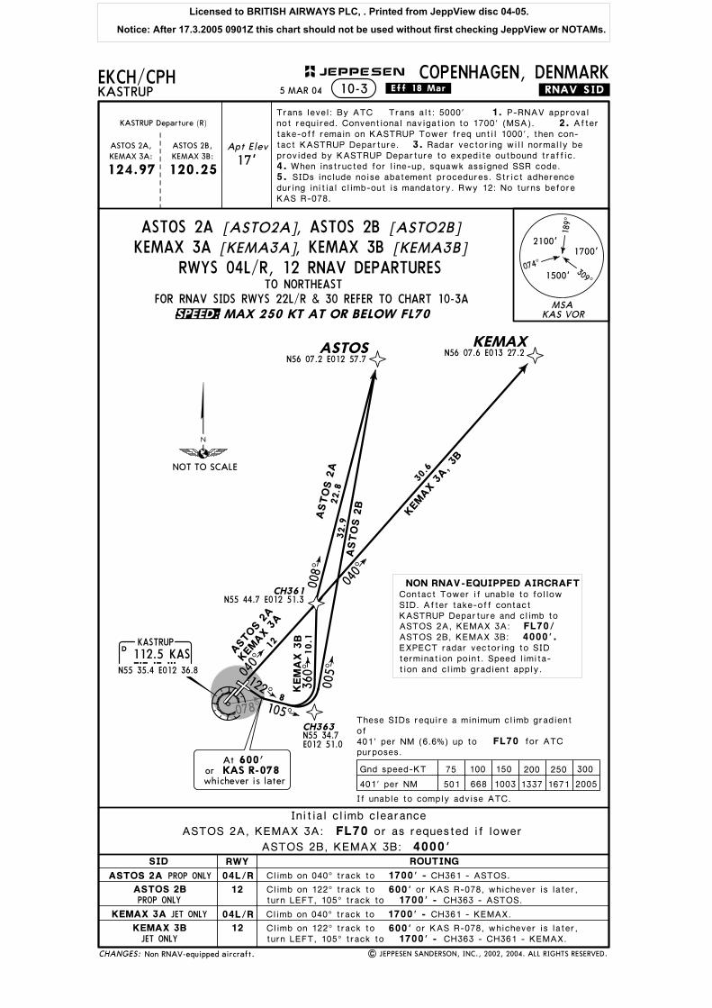
Climb on 040^ track to 1700' -
Climb on 040^ track to 1700' -
Climb on 122^ track to 600'1700' - CH363 - ASTOS.
1700' - CH363 - CH361 - KEMAX.Climb on 122^ track to 600'
N56 07.6 E013 27.2
5.
1. P-RNAV approvalnot required. Conventional navigation to 1700' (MSA). 2. Aftertake-off remain on KASTRUP Tower freq until 1000', then con-tact KASTRUP Departure. Radar vectoring will normally beprovided by KASTRUP Departure to expedite outbound traffic.
When instructed for line-up, squawk assigned SSR code.SIDs include noise abatement procedures. Strict adherence
during initial climb-out is mandatory. Rwy 12: No turns beforeKAS R-078.
CH361 - ASTOS.
CH361 - KEMAX.
Initial climb clearance
or KAS R-078, whichever is later,turn LEFT, 105^ track to
or KAS R-078, whichever is later,turn LEFT, 105^ track to
ASTOS 2A, KEMAX 3A: FL70 or as requested if lower
ASTOS 2B, KEMAX 3B: 4000'
At 600'or KAS R-078whichever is later
N55 34.7E012 51.0
Non RNAV-equipped aircraft.
FL70/4000'.
MSA
189^
309^
074^
2100'1700'
1500'
KAS VOR
CHANGES:
JEPPESEN
.Eff.18.Mar.
RWYSID
ASTOS 2A
ASTOS 2B
KEMAX 3A
KEMAX 3B
04L/R
12
04L/R
12
ROUTING
NOT TO SCALE
If unable to comply advise ATC.
These SIDs require a minimum climb gradientof 401' per NM (6.6%) up to for ATCpurposes.
N56 07.2 E012 57.7
75 100 150 200 250 300
401' per NM 501 1003 1337 1671 2005668
Gnd speed-KT
TO NORTHEASTRWYS 04L/R, 12 RNAV DEPARTURES
FOR RNAV SIDS RWYS 22L/R & 30 REFER TO CHART 10-3A
ASTOS 2A [ASTO2A], ASTOS 2B [ASTO2B][KEMA3B], KEMAX 3B[KEMA3A]KEMAX 3A
MAX 250 KT AT OR BELOW FL70
5 MAR 04
Contact Tower if unable to followSID. After take-off contactKASTRUP Departure and climb toASTOS 2A, KEMAX 3A:ASTOS 2B, KEMAX 3B:
NON RNAV-EQUIPPED AIRCRAFT
EXPECT radar vectoring to SIDtermination point. Speed limita-tion and climb gradient apply.
SPEED:
Licensed to BRITISH AIRWAYS PLC, . Printed from JeppView disc 04-05.
Notice: After 17.3.2005 0901Z this chart should not be used without first checking JeppView or NOTAMs.
358^
KASTRUP112.5 KASKAS
N55 35.4 E012 36.8
D
KEMAXN56 07.6 E013 27.2
CH370
CH398N55 48.8E012 20.8
302^
9.7095^14.3
320^
072^KEMAX 3D
CH361N55 44.7 E012 51.3
CH377N55 25.4 E012 23.5
CH381N55 22.1 E012 31.9
CH392N55 51.8 E013 02.2
040^00
8^
9.4
025^
5.8124^
RUBAT(Rwy 22R)
N55 34.1 E012 34.1
LARSO(Rwy 22L)
N55 33.9 E012 34.5
215^
KEMAX 3
C, 3D
N55 52.8E012 45.0 A
STO
S 2
C
ASTOS
21.2
22.8
25.2
ASTOS 2
CKEM
AX 3
C
EKCH/CPH
Trans level: By ATC Trans alt: 5000'
KASTRUPCOPENHAGEN, DENMARK
JET ONLY
PROP ONLY
PROP ONLY
JET ONLY
FL70
.RNAV.SID.
| JEPPESEN SANDERSON, INC., 2002, 2004. ALL RIGHTS RESERVED.
2100' -Climb on 302^ track to 600'
1. P-RNAV approval
2.
10-3A
not required. Conventional navigation to 1500' (Rwys 22L/R)/2100' (Rwy 30) (MSA). After take-off remain on KASTRUP
3.4.
5.
CH398 - CH370 - CH392 - KEMAX.
Climb on 302^ track to 600'2100' - CH398 - ASTOS.
1500',
1500',
Apt Elev
17'
11
16
At 600'or KAS R-358whichever is later
27.8
ASTOS 2D
047^
Ator
whichever is later1500'
KAS 2 DME
2 DME
4220^
KASTRUP Departure (R)
124.97 120.25
ASTOS 2C,KEMAX 3C:
ASTOS 2D,KEMAX 3D:
Tower freq until 1000', then contact KASTRUP Departure.Radar vectoring will normally be provided by KASTRUP
Departure to expedite outbound traffic. When instructed forline-up, squawk assigned SSR code. SIDs include noise aba-tement procedures. Strict adherence during initial climb-out ismandatory. No turns before KAS 2 DME (LARSO/RUBAT)(Rwys 22L/R)/KAS R-358 (Rwy 30).
Non RNAV-equipped aircraft.
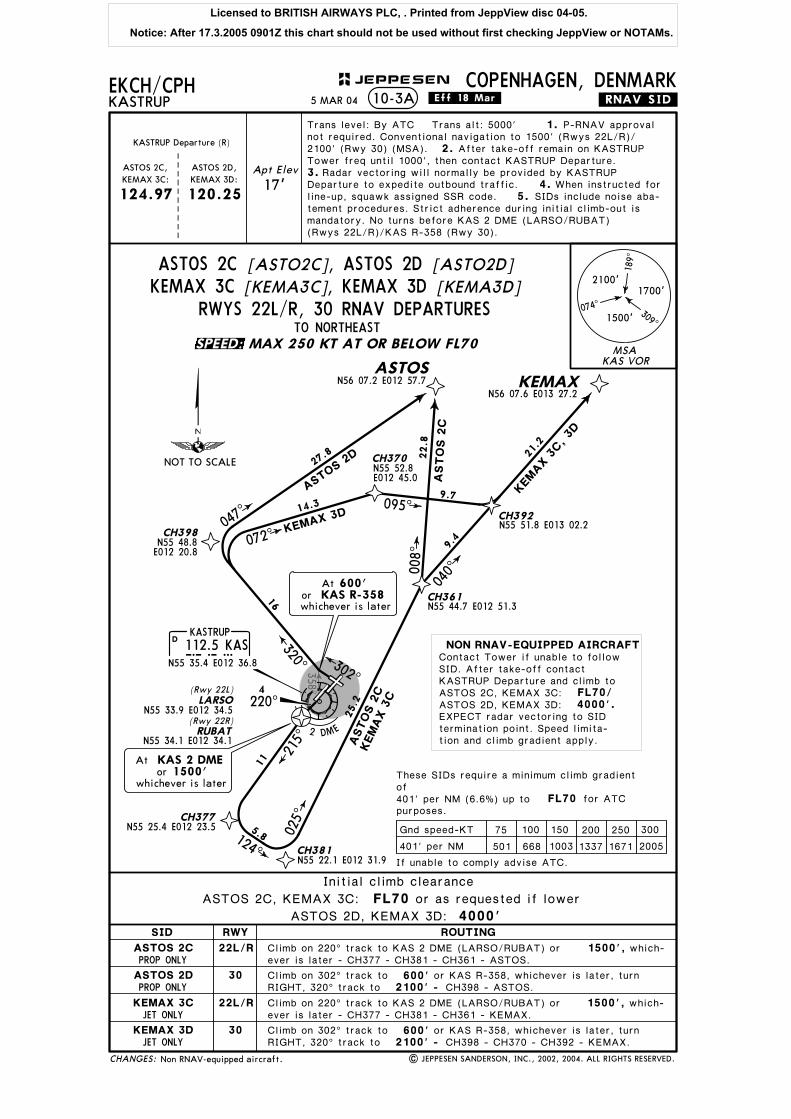
Climb on 220^ track to KAS 2 DME (LARSO/RUBAT) orever is later - CH377 - CH381 - CH361 - ASTOS.
which-
or KAS R-358, whichever is later, turnRIGHT, 320^ track to
Climb on 220^ track to KAS 2 DME (LARSO/RUBAT) or which-ever is later - CH377 - CH381 - CH361 - KEMAX.
or KAS R-358, whichever is later, turnRIGHT, 320^ track to
Initial climb clearance
FL70/4000'.
ASTOS 2D, KEMAX 3D: 4000'ASTOS 2C, KEMAX 3C: FL70 or as requested if lower
MSA
189^
309^
074^
2100'1700'
1500'
KAS VOR
N56 07.2 E012 57.7
CHANGES:
JEPPESEN
.Eff.18.Mar.
RWYSID
ASTOS 2C
ASTOS 2D
KEMAX 3C
KEMAX 3D
22L/R
30
22L/R
30
ROUTING
NOT TO SCALE
If unable to comply advise ATC.
These SIDs require a minimum climb gradientof 401' per NM (6.6%) up to for ATCpurposes.
75 100 150 200 250 300
401' per NM 501 1003 1337 1671 2005668
Gnd speed-KT
TO NORTHEASTRWYS 22L/R, 30 RNAV DEPARTURES
MAX 250 KT AT OR BELOW FL70
5 MAR 04
ASTOS 2C [ASTO2C], ASTOS 2D [ASTO2D]KEMAX 3C [KEMA3C], KEMAX 3D [KEMA3D]
Contact Tower if unable to followSID. After take-off contactKASTRUP Departure and climb toASTOS 2C, KEMAX 3C:ASTOS 2D, KEMAX 3D:
NON RNAV-EQUIPPED AIRCRAFT
EXPECT radar vectoring to SIDtermination point. Speed limita-tion and climb gradient apply.
SPEED:
Licensed to BRITISH AIRWAYS PLC, . Printed from JeppView disc 04-05.
Notice: After 17.3.2005 0901Z this chart should not be used without first checking JeppView or NOTAMs.

078^
KASTRUP112.5 KASKAS
N55 35.4 E012 36.8
D
CH361N55 44.7 E012 51.3
040^
CH362N55 40.9 E012 59.0
CH383N55 25.7 E013 02.6
CH382N55 24.6 E012 52.7
CH364
CH365N55 29.9 E012 44.9
19.1
10.6
2
11.6
5.8130^
215^
130^
123^6.9139^
150^
BALOX 2B
BALO
X 2A
, 2B
BALOX 2
A
SIM
EG 5
A
SIMEG
BALOX
SIMEG 5A, 5B
29.4
EKCH/CPHKASTRUP
COPENHAGEN, DENMARK
JET ONLY
PROP ONLY
PROP ONLY
JET ONLY
FL70
122^
.RNAV.SID.
| JEPPESEN SANDERSON, INC., 2002, 2004. ALL RIGHTS RESERVED.
Climb on 040^ track to 1700' -
Climb on 040^ track to 1700' -
Climb on 122^ track to 600'1700' - CH382 - BALOX.
Climb on 122^ track to 600'
10-3B
1700' - CH383 - SIMEG.
12
N55 15.0E013 30.1
N55 02.1E013 25.6
SIMEG
5B
At 600'or KAS R-078whichever is later 18
16
N55 31.6E012 47.0
Apt Elev
17'
Trans level: By ATC Trans alt: 5000' 1.2.
124.97
KASTRUPDeparture (R)
P-RNAV approval not re-quired. Conventional navigation to 1700' (MSA). After take-off re-
3.4.
5.
main on KASTRUP Tower freq until 1000', then contact KASTRUPDeparture. Radar vectoring will normally be provided by KASTRUPDeparture to expedite outbound traffic. When instructed for line-up,squawk assigned SSR code. SIDs include noise abatement procedu-res. Strict adherence during initial climb-out is mandatory. Rwy 12:No turns before KAS R-078.
CH361 - CH362 - CH364 - SIMEG.
or KAS R-078, whichever is later, turnRIGHT, 130^ track to
or KAS R-078, whichever is later, turnRIGHT, 150^ track to
CH361 - CH362 - CH365 - BALOX.
FL70/4000'.
SID SIMEG 5A routing text revised.
Initial climb clearance
BALOX 2A, SIMEG 5A: FL70 or as requested if lower
BALOX 2B, SIMEG 5B: 4000'
Initial climb clearance
MSA
189^
309^
074^
2100'1700'
1500'
KAS VOR
CHANGES:
JEPPESEN
RWYSID
BALOX 2A
BALOX 2B
SIMEG 5A
SIMEG 5B
04L/R
12
04L/R
12
ROUTING
NOT TO SCALE
If unable to comply advise ATC.
These SIDs require a minimum climb gradientof 401' per NM (6.6%) up to for ATCpurposes.
75 100 150 200 250 300
401' per NM 501 1003 1337 1671 2005668
Gnd speed-KT
TO SOUTHEASTRWYS 04L/R, 12 RNAV DEPARTURES
FOR RNAV SIDS RWYS 22L/R & 30 REFER TO CHART 10-3CMAX 250 KT AT OR BELOW FL70
7 MAY 04
BALOX 2A [BALO2A], BALOX 2B [BALO2B]SIMEG 5A [SIME5A], SIMEG 5B [SIME5B]
Contact Tower if unable to followSID. After take-off contactKASTRUP Departure and climb toBALOX 2A, SIMEG 5A:BALOX 2B, SIMEG 5B:
NON RNAV-EQUIPPED AIRCRAFT
EXPECT radar vectoring to SIDtermination point. Speed limita-tion and climb gradient apply.
SPEED:
Licensed to BRITISH AIRWAYS PLC, . Printed from JeppView disc 04-05.
Notice: After 17.3.2005 0901Z this chart should not be used without first checking JeppView or NOTAMs.

358^KASTRUP112.5 KASKAS
N55 35.4 E012 36.8
D
CH383N55 25.7 E013 02.6
CH382
SIMEGN55 15.0 E013 30.1
BALOXN55 02.1 E013 25.6
CH377
CH381N55 22.1 E012 31.9
N55 25.4E012 23.5
N55 24.6E012 52.7
19.1
5.8
215^
124^
077^
12.15.8
BALOX 2CSIMEG 6C
CH364N55 31.6 E012 47.0
CH365
CH374
CH399
N55 32.4E012 22.6
123^
139^
13.912.9100^
092^
189^ 290^
9
8.2
N55 29.9E012 44.9
BALO
X 2C
, 2D
SIMEG 6C, 5D
10.6
6.9
N55 40.4 E012 25.2 BALOX 2DSIMEG 5D
29.4
Apt Elev
17'
EKCH/CPH
Trans level: By ATC Trans alt: 5000'
KASTRUPCOPENHAGEN, DENMARK
JET ONLY
PROP ONLY
PROP ONLY
JET ONLY
FL70
.RNAV.SID.
| JEPPESEN SANDERSON, INC., 2002, 2004. ALL RIGHTS RESERVED.
1.
10-3C
124.97
2.
5.
3.
1500',
2100' -Climb on 302^ track to 600'
CH399 - CH374 - CH364 - SIMEG.
1500',
600'Climb on 302^ track to2100' - CH399 - CH374 - CH365 - BALOX.
302^
At 600'or KAS R-358whichever is later
2 DME
4220^
11
RUBAT(Rwy 22R)
N55 34.1 E012 34.1
LARSO(Rwy 22L)
N55 33.9 E012 34.5
Ator
whichever is later1500'
KAS 2 DME
KASTRUPDeparture (R)
P-RNAV approval not re-quired. Conventional navigation to 1500' (Rwys 22L/R)/ 2100' (Rwy 30)(MSA). After take-off remain on KASTRUP Tower freq until 1000',then contact KASTRUP Departure. Radar vectoring will normally beprovided by KASTRUP Departure to expedite outbound traffic. 4. Wheninstructed for line-up, squawk assigned SSR code. SIDs includenoise abatement procedures. Strict adherence during initial climb-out ismandatory. No turns before KAS 2 DME (LARSO/RUBAT) (Rwys 22L/R)/KAS R-358 (Rwy 30).
Climb on 220^ track to KAS 2 DME (LARSO/RUBAT) orever is later - CH377 - CH381 - CH382 - BALOX.
which-
or KAS R-358, whichever is later, turnLEFT, 290^ track to
Climb on 220^ track to KAS 2 DME (LARSO/RUBAT) or which-ever is later - CH377 - CH381 - CH383 - SIMEG.
or KAS R-358, whichever is later, turnLEFT, 290^ track to
Initial climb clearance
BALOX 2C, SIMEG 6C: FL70 or as requested if lower
BALOX 2D, SIMEG 5D: 4000'
FL70/ 4000'.
See other side.
Initial climb clearance
MSA
189^
309^
074^
2100'1700'
1500'
KAS VOR
CHANGES:
JEPPESEN
RWYSID
BALOX 2C
BALOX 2D
SIMEG 6C
SIMEG 5D
22L/R
30
22L/R
30
ROUTING
NOT TO SCALE
If unable to comply advise ATC.
These SIDs require a minimum climb gradientof 401' per NM (6.6%) up to for ATCpurposes.
75 100 150 200 250 300
401' per NM 501 1003 1337 1671 2005668
Gnd speed-KT
TO SOUTHEASTRWYS 22L/R, 30 RNAV DEPARTURES
MAX 250 KT AT OR BELOW FL70
7 MAY 04
BALOX 2C [BALO2C], BALOX 2D [BALO2D]SIMEG 6C [SIME6C], SIMEG 5D [SIME5D]
NON RNAV-EQUIPPED AIRCRAFT
BALOX 2D, SIMEG 5D:
Contact Tower if unable to follow SID. After take-off con-tact KASTRUP Departure and climb toBALOX 2C, SIMEG 6C:EXPECT radar vectoring to SID termination point. Speedlimitation and climb gradient apply.
SPEED:
Licensed to BRITISH AIRWAYS PLC, . Printed from JeppView disc 04-05.
Notice: After 17.3.2005 0901Z this chart should not be used without first checking JeppView or NOTAMs.

078^
040^
MAXELN55 12.6 E011 54.1
BISTAN55 12.2 E012 07.4
CH365N55 29.9 E012 44.9
CH366N55 23.8 E012 37.2
CH361N55 44.7 E012 51.3
CH362N55 40.9E012 59.0
5.8
13.6
7.6
235^
215^
130^
238^
MAXEL 2A
BISTA 2
A
BIS
TA 2
A
MAXEL 2
A
CH395N55 27.0 E012 46.1
CH396N55 24.1 E012 47.3
122^165^
3
33
242^
243^
BISTA 2B
MAXEL 2B
KASTRUP112.5 KASKAS
N55 35.4 E012 36.8
D
33.8
20.6
25.8
EKCH/CPHKASTRUP
COPENHAGEN, DENMARK
JET ONLY
PROP ONLY
PROP ONLY
JET ONLY
FL70
.RNAV.SID.
| JEPPESEN SANDERSON, INC., 2002, 2004. ALL RIGHTS RESERVED.
Climb on 040^ track to 1700' -
Climb on 040^ track to 1700' -
Climb on 122^ track to 600'1700' - CH396 - BISTA.
Climb on 122^ track to 600'
10-3D
1700' - CH395 - MAXEL.
3
12
9
At 600'or KAS R-078whichever is later
MA
XEL 2
BBISTA
2B
Apt Elev
17'
Trans level: By ATC Trans alt: 5000' 1.2.
124.97
KASTRUPDeparture (R)
P-RNAV approval not re-quired. Conventional navigation to 1700' (MSA). After take-off re-
3.4.
5.
main on KASTRUP Tower freq until 1000', then contact KASTRUPDeparture. Radar vectoring will normally be provided by KASTRUPDeparture to expedite outbound traffic. When instructed for line-up,squawk assigned SSR code. SIDs include noise abatement procedu-res. Strict adherence during initial climb-out is mandatory. Rwy 12:No turns before KAS R-078.
Non RNAV-equipped aircraft.
CH361 - CH362 - CH366 - BISTA.
CH361 - CH362 - CH365 - MAXEL.
or KAS R-078, whichever is later, turnRIGHT, 165^ track to
or KAS R-078, whichever is later, turnRIGHT, 165^ track to
Initial climb clearance
FL70/4000'.
BISTA 2B, MAXEL 2B: 4000'BISTA 2A, MAXEL 2A: FL70 or as requested if lower
MSA
189^
309^
074^
2100'1700'
1500'
KAS VOR
CHANGES:
JEPPESEN
.Eff.18.Mar.
RWYSID
BISTA 2A
BISTA 2B
MAXEL 2A
MAXEL 2B
04L/R
12
04L/R
12
ROUTING
NOT TO SCALE
If unable to comply advise ATC.
These SIDs require a minimum climb gradientof 401' per NM (6.6%) up to for ATCpurposes.
75 100 150 200 250 300
401' per NM 501 1003 1337 1671 2005668
Gnd speed-KT
TO SOUTHWESTRWYS 04L/R, 12 RNAV DEPARTURES
FOR RNAV SIDS RWYS 22L/R & 30 REFER TO CHART 10-3EMAX 250 KT AT OR BELOW FL70
5 MAR 04
BISTA 2A [BIST2A], BISTA 2B [BIST2B]MAXEL 2A [MAXE2A], MAXEL 2B [MAXE2B]
Contact Tower if unable to followSID. After take-off contactKASTRUP Departure and climb toBISTA 2A, MAXEL 2A:BISTA 2B, MAXEL 2B:
NON RNAV-EQUIPPED AIRCRAFT
EXPECT radar vectoring to SIDtermination point. Speed limita-tion and climb gradient apply.
SPEED:
Licensed to BRITISH AIRWAYS PLC, . Printed from JeppView disc 04-05.
Notice: After 17.3.2005 0901Z this chart should not be used without first checking JeppView or NOTAMs.

358 ^ KASTRUP112.5 KASKAS
N55 35.4 E012 36.8
D
215^22
7^
(Rwy 22L)LARSO
(Rwy 22R)RUBATN55 34.1 E012 34.1
MAXEL
2C
BIS
TA 2
C
CH374
CH399
189^
290^
9
8.2
302^
N55 32.4 E012 22.6
BISTAMAXEL
22
218^
202^
BIS
TA 2
D
MAXEL 2
D
N55 33.9 E012 34.5
25.6
EKCH/CPHKASTRUP
COPENHAGEN, DENMARK
JET ONLY
PROP ONLY
PROP ONLY
JET ONLY
.RNAV.SID.
| JEPPESEN SANDERSON, INC., 2002, 2004. ALL RIGHTS RESERVED.
10-3E
1500',
2100' -Climb on 302^ track to 600'
1500',
600'Climb on 302^ track to2100' -
2 DME
4220^
CH399 - CH374 - BISTA.
CH399 - CH374 - MAXEL.
FL70
31
27 Ator
whichever is later1500'
KAS 2 DME
At 600'or KAS R-358whichever is later
N55 12.2E012 07.4
N55 12.6E011 54.1
Apt Elev
17'
Trans level: By ATC Trans alt: 5000' 1.
124.97
2.KASTRUP
Departure (R)
P-RNAV approval not re-quired. Conventional navigation to 1500' (Rwys 22L/R)/ 2100' (Rwy 30)(MSA).
5.
3.After take-off remain on KASTRUP Tower freq until 1000',
then contact KASTRUP Departure. Radar vectoring will normally beprovided by KASTRUP Departure to expedite outbound traffic. 4. Wheninstructed for line-up, squawk assigned SSR code. SIDs includenoise abatement procedures. Strict adherence during initial climb-out ismandatory. No turns before KAS 2 DME (LARSO/RUBAT) (Rwys 22L/R)/KAS R-358 (Rwy 30).
N55 40.4E012 25.2
FL70/4000'.
Climb on 220^ track to KAS 2 DME (LARSO/RUBAT) orever is later - BISTA.
which-
or KAS R-358, whichever is later, turnLEFT, 290^ track to
Climb on 220^ track to KAS 2 DME (LARSO/RUBAT) or which-ever is later - MAXEL.
or KAS R-358, whichever is later, turnLEFT, 290^ track to
Initial climb clearance
BISTA 2C, MAXEL 2C: FL70 or as requested if lower
BISTA 2D, MAXEL 2D: 4000'
Non RNAV-equipped aircraft.
MSA
189^
309^
074^
2100'1700'
1500'
KAS VOR
CHANGES:
JEPPESEN
.Eff.18.Mar.
RWYSID
BISTA 2C
BISTA 2D
MAXEL 2C
MAXEL 2D
22L/R
30
22L/R
30
ROUTING
NOT TO SCALE
TO SOUTHWESTRWYS 22L/R, 30 RNAV DEPARTURES
MAX 250 KT AT OR BELOW FL70
5 MAR 04
[BIST2C]BISTA 2C , BISTA 2D [BIST2D]MAXEL 2C [MAXE2C], MAXEL 2D [MAXE2D]
If unable to comply advise ATC.
These SIDs require a minimum climb gradientof 401' per NM (6.6%) up to for ATCpurposes.
75 100 150 200 250 300
401' per NM 501 1003 1337 1671 2005668
Gnd speed-KT
Contact Tower if unable to followSID. After take-off contactKASTRUP Departure and climb toBISTA 2C, MAXEL 2C:BISTA 2D, MAXEL 2D:
NON RNAV-EQUIPPED AIRCRAFT
EXPECT radar vectoring to SIDtermination point. Speed limita-tion and climb gradient apply.
SPEED:
Licensed to BRITISH AIRWAYS PLC, . Printed from JeppView disc 04-05.
Notice: After 17.3.2005 0901Z this chart should not be used without first checking JeppView or NOTAMs.

KASTRUP
112.5 KASKASN55 35.4 E012 36.8
D
CH361
040^
CH368N55 46.9 E012 43.2
010^
CH371N55 52.7 E012 06.4
DOBEL
TOBISN55 15.1 E011 40.6
CH363N55 34.7E012 51.0
N55 44.7E012 51.3
CH362N55 40.9E012 59.0
5.8
7.8
243^
215^
130^
235^
285^
TOBIS 2A
N55 36.4 E011 23.4
DOBEL 2A
29.3
21.5
44.6
Apt Elev
17'
EKCH/CPH
Trans level: By ATC Trans alt: 5000'
KASTRUPCOPENHAGEN, DENMARK
3.
4.
JET ONLY
FL70
.RNAV.SID.
| JEPPESEN SANDERSON, INC., 2002, 2003. ALL RIGHTS RESERVED.
Climb on 040^ track to 1700' -
Climb on 040^ track to 600'1700' -
5.
1. P-RNAV approvalnot required. Conventional navigation to 1700' (MSA). 2. After
10-3F
KASTRUP Departure (R)
120.25 124.97DOBEL 2A: TOBIS 2A:
CH368 - CH371 - DOBEL.
12
11
3DM
E
At 600'or KAS 3 DMEwhichever is later
DOBEL 2A
take-off remain on KASTRUP Tower freq until 1000', then con-tact KASTRUP Departure. Radar vectoring will normally beprovided by KASTRUP Departure to expedite outbound traffic.
When instructed for line-up, squawk assigned SSR code.SIDs include noise abatement procedures. Strict adherence
during initial climb-out is mandatory.
See other side.
CH361 - CH362 - CH363 - TOBIS.
or KAS 3 DME, whichever is later, turn LEFT,010^ track to
Initial climb clearance FL70 or as requested if lower
FL70.
MSA
189^
309^
074^
2100'1700'
1500'
KAS VOR
CHANGES:
JEPPESEN
.Eff.18.Mar.
SID
DOBEL 2A
TOBIS 2A
ROUTING
NOT TO SCALE
If unable to comply advise ATC.
These SIDs require a minimum climb gradientof 401' per NM (6.6%) up to for ATCpurposes.
75 100 150 200 250 300
401' per NM 501 1003 1337 1671 2005668
Gnd speed-KT
FOR RNAV SIDS RWYS 12 & 22L/R REFER TO CHART 10-3G
MAX 250 KT AT OR BELOW FL70
5 MAR 04
DOBEL 2A [DOBE2A], TOBIS 2A [TOBI2A]RWYS 04L/R RNAV DEPARTURES
TO WEST
FOR RNAV SIDS RWY 30 REFER TO CHART 10-3H
NON RNAV-EQUIPPEDAIRCRAFT
Contact Tower if unable tofollow SID. After take-offcontact KASTRUP Departureand climb to EXPECTradar vectoring to SID ter-mination point. Speed limita-tion and climb gradient apply.
SPEED:
Licensed to BRITISH AIRWAYS PLC, . Printed from JeppView disc 04-05.
Notice: After 17.3.2005 0901Z this chart should not be used without first checking JeppView or NOTAMs.
078^
KASTRUP112.5 KASKAS
N55 35.4 E012 36.8
D
122^
(Rwy 22L)LARSO
(Rwy 22R)RUBAT
N55 34.1 E012 34.1
CH365N55 29.9E012 44.9
TOBISN55 15.1 E011 40.6
DOBELN55 36.4 E011 23.4
165^
247^
238^
273^
TOBIS 2B
DOBEL 2C
TOBIS 2
C
CH361
360^
10.1
CH363N55 34.7E012 51.0
105^
304^
DO
BEL 3
B
CH378N55 56.3 E012 21.6
238^
N55 33.9 E012 34.5
N55 44.7E012 51.3
20.3
38.5
39.6
Apt Elev
17'
EKCH/CPH
Trans level: By ATC Trans alt: 5000'
KASTRUPCOPENHAGEN, DENMARK
4.
.RNAV.SID.
| JEPPESEN SANDERSON, INC., 2002, 2004. ALL RIGHTS RESERVED.
5.
1. P-RNAV approval
2.
10-3G
KASTRUP Departure (R)
120.25 124.97
DOBEL3B, 2C:
TOBIS2B, 2C:
not required. Conventional navigation to 1700' (Rwy 12)/1500'(Rwys 22L/R) (MSA). After take-off remain on KASTRUP
3.
FL70
JET ONLY
JET ONLY
Climb on 122^ track to 600'1700' - CH363 - CH361 - CH378 - DOBEL.
Climb on 122^ track to 600'1700' - CH365 - TOBIS.
1500',
36
9
840
1
1500',
Ator
whichever is later1500'
KAS 2 DME 4220^
2 DME
At 600'or KAS R-078whichever is later
1
Tower freq until 1000', then contact KASTRUP Departure.Radar vectoring will normally be provided by KASTRUP
Departure to expedite outbound traffic. When instructed forline-up, squawk assigned SSR code. SIDs include noise aba-tement procedures. Strict adherence during initial climb-out ismandatory. No turns before KAS R-078 (Rwy 12)/KAS 2 DME(LARSO/RUBAT) (Rwys 22L/R).
Non RNAV-equipped aircraft.
Climb on 220^ track to KAS 2 DME (LARSO/RUBAT or which-ever is later - TOBIS.
or KAS R-078, whichever is later, turn
or KAS R-078, whichever is later, turnLEFT, 105^ track to
RIGHT, 165^ track to
Climb on 220^ track to KAS 2 DME (LARSO/RUBAT or which-ever is later - DOBEL.
FL70.4000'/
Initial climb clearance
DOBEL 3B, TOBIS 2B: 4000'DOBEL 2C, TOBIS 2C: FL70 or as requested if lower
MSA
189^
309^
074^
2100'1700'
1500'
KAS VOR
NOT TO SCALE
CHANGES:
JEPPESEN
.Eff.18.Mar.
MAX 250 KT AT OR BELOW FL70
5 MAR 04
TO WESTFOR RNAV SIDS RWY 30 REFER TO CHART 10-3H
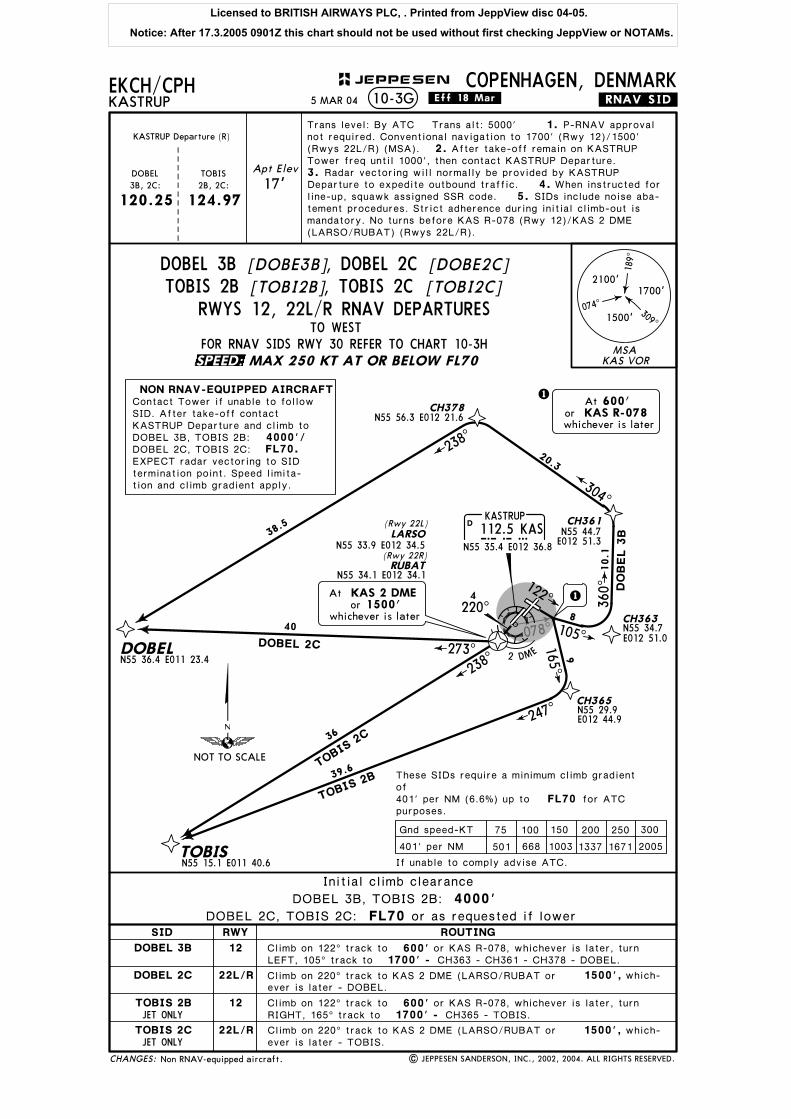
DOBEL 3B [DOBE3B], DOBEL 2C [DOBE2C]TOBIS 2B [TOBI2B], TOBIS 2C [TOBI2C]
RWYS 12, 22L/R RNAV DEPARTURES
RWYSID
DOBEL 3B
DOBEL 2C
TOBIS 2B
TOBIS 2C
ROUTING
If unable to comply advise ATC.
These SIDs require a minimum climb gradientof 401' per NM (6.6%) up to for ATCpurposes.
75 100 150 200 250 300
401' per NM 501 1003 1337 1671 2005668
Gnd speed-KT
12
22L/R
12
22L/R
Contact Tower if unable to followSID. After take-off contactKASTRUP Departure and climb toDOBEL 3B, TOBIS 2B:DOBEL 2C, TOBIS 2C:
NON RNAV-EQUIPPED AIRCRAFT
EXPECT radar vectoring to SIDtermination point. Speed limita-tion and climb gradient apply.
SPEED:
Licensed to BRITISH AIRWAYS PLC, . Printed from JeppView disc 04-05.
Notice: After 17.3.2005 0901Z this chart should not be used without first checking JeppView or NOTAMs.

358 ^
KASTRUP112.5 KASKAS
N55 35.4 E012 36.8
D
CH399
290^
9302^
N55 40.4 E012 25.2
263^
224^
DOBEL 2D
TOBI
S 2D
DOBELN55 36.4 E011 23.4
TOBISN55 15.1 E011 40.6
35.2
35.8
Apt Elev
17'
EKCH/CPH
Trans level: By ATC Trans alt: 5000'
KASTRUPCOPENHAGEN, DENMARK
3.
4.
JET ONLY
FL70
.RNAV.SID.
| JEPPESEN SANDERSON, INC., 2002, 2004. ALL RIGHTS RESERVED.
Climb on 302^ track to 600'2100' -
5.
1. P-RNAV approvalnot required. Conventional navigation to 2100' (MSA). 2. After
10-3H
KASTRUP Departure (R)
120.25 124.97DOBEL 2D: TOBIS 2D:
CH399 - DOBEL.
Climb on 302^ track to 600'2100' - CH399 - TOBIS.
At 600'or KAS R-358whichever is later
take-off remain on KASTRUP Tower freq until 1000', then con-tact KASTRUP Departure. Radar vectoring will normally beprovided by KASTRUP Departure to expedite outbound traffic.
When instructed for line-up, squawk assigned SSR code.SIDs include noise abatement procedures. Strict adherence
during initial climb-out is mandatory. No turns before KASR-358.
4000'.
or KAS R-358, whichever is later, turn LEFT,290^ track to
or KAS R-358, whichever is later, turn LEFT,290^ track to
Initial climb clearance 4000'
Non RNAV-equipped aircraft.
MSA
189^
309^
074^
2100'1700'
1500'
KAS VOR
CHANGES:
JEPPESEN
.Eff.18.Mar.
SID
DOBEL 2D
TOBIS 2D
ROUTING
NOT TO SCALE
If unable to comply advise ATC.
These SIDs require a minimum climb gradientof 401' per NM (6.6%) up to for ATCpurposes.
75 100 150 200 250 300
401' per NM 501 1003 1337 1671 2005668
Gnd speed-KT
MAX 250 KT AT OR BELOW FL70
5 MAR 04
TO WEST
DOBEL 2D [DOBE2D], TOBIS 2D [TOBI2D]RWY 30 RNAV DEPARTURES
NON RNAV-EQUIPPEDAIRCRAFT
Contact Tower if unable tofollow SID. After take-offcontact KASTRUP Departureand climb to EXPECTradar vectoring to SID ter-mination point. Speed limita-tion and climb gradient apply.
SPEED:
Licensed to BRITISH AIRWAYS PLC, . Printed from JeppView disc 04-05.
Notice: After 17.3.2005 0901Z this chart should not be used without first checking JeppView or NOTAMs.

078^
KASTRUP
112.5 KASKASN55 35.4 E012 36.8
D
010^
E012 51.3
CH361
CH389
CH370N55 52.8 E012 45.0
CH369N55 49.8 E012 44.1
CH379N56 00.0 E012 21.5
CH378N55 56.3 E012 21.6
MIRGON56 02.1 E011 59.9
SORGAN55 58.9E011 48.8
N55 44.7
N55 48.0E012 52.2
12.3
18.6 277^
279^
304^
304^
21
289^
286^ 3
SORGA 2B
MIRGO 2B
MIRGO 2A
SORGA 2A
122^
CH363
105^
10.1
13.4
360^
002^
MIRGO2B
SORGA2B
20.3
27.1
32.4
EKCH/CPHKASTRUP
COPENHAGEN, DENMARK
JET ONLY
PROP ONLY
PROP ONLY
JET ONLY
FL70
.RNAV.SID.
| JEPPESEN SANDERSON, INC., 2002, 2004. ALL RIGHTS RESERVED.
Climb on 040^ track to
Climb on 122^ track to 600'1700' -
Climb on 122^ track to 600'
10-3J
CH363 - CH389 - CH379 - MIRGO.
1700' - CH363 - CH361 - CH378 - SORGA.
600'1700' - CH369 - SORGA.
Climb on 040^ track to 600'1700' - CH370 - MIRGO.
13
8
At 600'or KAS R-078whichever is later
N55 34.7E012 51.0
3
DME
SO
RG
A 2
A
MIRG
O 2
A
At 600'or KAS 3 DMEwhichever is later
040^
Apt Elev
17'
Trans level: By ATC Trans alt: 5000' 1.2.
120.25
KASTRUPDeparture (R)
P-RNAV approval not re-quired. Conventional navigation to 1700' (MSA). After take-off re-
3.4.
5.
main on KASTRUP Tower freq until 1000', then contact KASTRUPDeparture. Radar vectoring will normally be provided by KASTRUPDeparture to expedite outbound traffic. When instructed for line-up,squawk assigned SSR code. SIDs include noise abatement procedu-res. Strict adherence during initial climb-out is mandatory. Rwy 12:No turns before KAS R-078.
Non RNAV-equipped aircraft.
or KAS 3 DME, whichever is later, turnLEFT, 010^ track to
or KAS R-078, whichever is later, turnLEFT, 105^ track to
or KAS 3 DME, whichever is later, turnLEFT, 010^ track to
or KAS R-078, whichever is later, turnLEFT, 105^ track to
Initial climb clearance
MIRGO 2B, SORGA 2B: 4000'MIRGO 2A, SORGA 2A: FL70 or as requested if lower
FL70/4000'.
MSA
189^
309^
074^
2100'1700'
1500'
KAS VOR
CHANGES:
JEPPESEN
.Eff.18.Mar.
RWYSID
MIRGO 2A
MIRGO 2B
SORGA 2A
SORGA 2B
04L/R
12
04L/R
12
ROUTING
NOT TO SCALE
If unable to comply advise ATC.
These SIDs require a minimum climb gradientof 401' per NM (6.6%) up to for ATCpurposes.
75 100 150 200 250 300
401' per NM 501 1003 1337 1671 2005668
Gnd speed-KT
TO NORTHWESTRWYS 04L/R, 12 RNAV DEPARTURES
FOR RNAV SIDS RWYS 22L/R & 30 REFER TO CHART 10-3KMAX 250 KT AT OR BELOW FL70
5 MAR 04
, SORGA 2B [SORG2B][SORG2A]SORGA 2A[MIRG2B], MIRGO 2B[MIRG2A]MIRGO 2A
Contact Tower if unable to followSID. After take-off contactKASTRUP Departure and climb toMIRGO 2A, SORGA 2A:MIRGO 2B, SORGA 2B:
NON RNAV-EQUIPPED AIRCRAFT
EXPECT radar vectoring to SIDtermination point. Speed limita-tion and climb gradient apply.
SPEED:
Licensed to BRITISH AIRWAYS PLC, . Printed from JeppView disc 04-05.
Notice: After 17.3.2005 0901Z this chart should not be used without first checking JeppView or NOTAMs.

35 8^
KASTRUP112.5 KASKAS
N55 35.4 E012 36.8
D
CH384CH385
351^ 359^
273^3
SO
RG
A 2
C
MIRG
O 2
C
MIRGON56 02.1 E011 59.9
SORGA
CH398N55 48.8 E012 20.8
MIR
GO 2D
SORGA 2D
299^
318^
320^
17.8N55 58.9 E011 48.8
N55 35.6 E011 54.6
20.7
26.82
3.6
N55 35.4E011 59.9
EKCH/CPHKASTRUP
COPENHAGEN, DENMARK
JET ONLY
PROP ONLY
PROP ONLY
JET ONLY
FL70
.RNAV.SID.
| JEPPESEN SANDERSON, INC., 2002, 2004. ALL RIGHTS RESERVED.
10-3K
1500',
2100' -Climb on 302^ track to 600'
1500',
600'Climb on 302^ track to2100' -
302^
At 600'or KAS R-358whichever is later
2 DME
4220^
RUBAT(Rwy 22R)
N55 34.1 E012 34.1
LARSO(Rwy 22L)
N55 33.9 E012 34.5
CH398 - MIRGO.
CH398 - SORGA.
20
16
Ator
whichever is later1500'
KAS 2 DME
Apt Elev
17'
Trans level: By ATC Trans alt: 5000' 1.
120.25
2.KASTRUP
Departure (R)
P-RNAV approval not re-quired. Conventional navigation to 1500' (Rwys 22L/R)/ 2100' (Rwy 30)(MSA).
5.
3.After take-off remain on KASTRUP Tower freq until 1000',
then contact KASTRUP Departure. Radar vectoring will normally beprovided by KASTRUP Departure to expedite outbound traffic. 4. Wheninstructed for line-up, squawk assigned SSR code. SIDs includenoise abatement procedures. Strict adherence during initial climb-out ismandatory. No turns before KAS 2 DME (LARSO/RUBAT) (Rwys 22L/R)/KAS R-358 (Rwy 30).
FL70/4000'.
Climb on 220^ track to KAS 2 DME (LARSO/RUBAT) or which-ever is later - CH385 - MIRGO.
or KAS R-358, whichever is later, turnRIGHT, 320^ track to
Climb on 220^ track to KAS 2 DME (LARSO/RUBAT) or which-ever is later - CH384 - SORGA.
or KAS R-358, whichever is later, turnRIGHT, 320^ track to
Initial climb clearance
MIRGO 2C, SORGA 2C: FL70 or as requested if lower
MIRGO 2D, SORGA 2D: 4000'
Non RNAV-equipped aircraft.
MSA
189^
309^
074^
2100'1700'
1500'
KAS VOR
CHANGES:
JEPPESEN
.Eff.18.Mar.
RWYSID
MIRGO 2C
MIRGO 2D
SORGA 2C
SORGA 2D
22L/R
30
22L/R
30
ROUTING
NOT TO SCALE
If unable to comply advise ATC.
These SIDs require a minimum climb gradientof 401' per NM (6.6%) up to for ATCpurposes.
75 100 150 200 250 300
401' per NM 501 1003 1337 1671 2005668
Gnd speed-KT
TO NORTHWESTRWYS 22L/R, 30 RNAV DEPARTURES
MAX 250 KT AT OR BELOW FL70
5 MAR 04
MIRGO 2C [MIRG2C], MIRGO 2D [MIRG2D], SORGA 2D [SORG2D][SORG2C]SORGA 2C
Contact Tower if unable to followSID. After take-off contactKASTRUP Departure and climb toMIRGO 2C, SORGA 2C:MIRGO 2D, SORGA 2D:
NON RNAV-EQUIPPED AIRCRAFT
EXPECT radar vectoring to SIDtermination point. Speed limita-tion and climb gradient apply.
SPEED:
Licensed to BRITISH AIRWAYS PLC, . Printed from JeppView disc 04-05.
Notice: After 17.3.2005 0901Z this chart should not be used without first checking JeppView or NOTAMs.

078^
CH390
CH363N55 34.7 E012 51.0
N55 51.3E012 53.1
CH370N55 52.8 E012 45.0
R124^R127^
307^ 304^
003^
16.7
NORA 5B
NORA 5A
21.926.4
KASTRUP
112.5 KASKASN55 35.4 E012 36.8
D
010^
122^105^
Apt Elev
17'
EKCH/CPH
Trans level: By ATC Trans alt: 5000'
KASTRUPCOPENHAGEN, DENMARK
FL70
.RNAV.SID.
| JEPPESEN SANDERSON, INC., 2002, 2004. ALL RIGHTS RESERVED.
Climb on 122^ track to 600'1700' -
1.2.
10-3L
120.25
Climb on 040^ track to 600'1700' -
8
3
DME
At 600'or KAS 3 DMEwhichever is later
040^
KASTRUPDeparture (R)
P-RNAV approval not re-quired. Conventional navigation to 1700' (MSA). After take-off re-
CH370 - NOA.
CH363 - CH390 - NOA.
17
At 600'or KAS R-078whichever is later
3.4.
5.
main on KASTRUP Tower freq until 1000', then contact KASTRUPDeparture. Radar vectoring will normally be provided by KASTRUPDeparture to expedite outbound traffic. When instructed for line-up,squawk assigned SSR code. SIDs include noise abatement procedu-res. Strict adherence during initial climb-out is mandatory. Rwy 12:No turns before KAS R-078.
Non RNAV-equipped aircraft.
or KAS 3 DME, whichever is later, turnLEFT, 010^ track to
or KAS R-078, whichever is later, turnLEFT, 105^ track to
Initial climb clearance
NORA 5A: FL70 or as requested if lower
NORA 5B: 4000'
FL70/ 4000'.
MSA
189^
309^
074^
2100'1700'
1500'
KAS VOR
NORA112.6 NOANOA
N56 06.3 E012 14.5
CHANGES:
JEPPESEN
.Eff.18.Mar.
RWYSID
NORA 5A
NORA 5B
04L/R
12
ROUTING
NOT TO SCALE
If unable to comply advise ATC.
These SIDs require a minimum climb gradientof 401' per NM (6.6%) up to for ATCpurposes.
75 100 150 200 250 300
401' per NM 501 1003 1337 1671 2005668
Gnd speed-KT
TO NORTHWESTRWYS 04L/R, 12 RNAV DEPARTURES
FOR RNAV SIDS RWYS 22L/R & 30 REFER TO CHART 10-3MMAX 250 KT AT OR BELOW FL70
5 MAR 04
NORA 5A, NORA 5B
NON RNAV-EQUIPPED AIRCRAFTContact Tower if unable to followSID. After take-off contactKASTRUP Departure and climb toNORA 5A: NORA 5B:EXPECT radar vectoring to SIDtermination point. Speed limitationand climb gradient apply.
SPEED:
Licensed to BRITISH AIRWAYS PLC, . Printed from JeppView disc 04-05.
Notice: After 17.3.2005 0901Z this chart should not be used without first checking JeppView or NOTAMs.

3 58^ KASTRUP112.5 KASKAS
N55 35.4 E012 36.8
D
CH398N55 48.8 E012 20.8
NORA 5D
320^CH386N55 39.8 E012 06.5
27
289^
R188
^
348^
R168^
18
NORA 6C
008^
Apt Elev
17'
EKCH/CPH
Trans level: By ATC Trans alt: 5000'
KASTRUPCOPENHAGEN, DENMARK
FL70
.RNAV.SID.
| JEPPESEN SANDERSON, INC., 2002, 2004. ALL RIGHTS RESERVED.
Climb on 302^ track to 600'2100' -
1.
10-3M
120.25
KASTRUPDeparture (R)
P-RNAV approval not re-
2.quired. Conventional navigation to 1500' (Rwys 22L/R)/ 2100' (Rwy 30)(MSA).
1500',
CH398 - NOA.
16
17 302^
At 600'or KAS R-358whichever is later
2 DME
4220^
RUBAT(Rwy 22R)
LARSO(Rwy 22L)
N55 33.9 E012 34.5
N55 34.1 E012 34.1
Ator
whichever is later1500'
KAS 2 DME
5.
3.After take-off remain on KASTRUP Tower freq until 1000',
then contact KASTRUP Departure. Radar vectoring will normally beprovided by KASTRUP Departure to expedite outbound traffic. 4. Wheninstructed for line-up, squawk assigned SSR code. SIDs includenoise abatement procedures. Strict adherence during initial climb-out ismandatory. No turns before KAS 2 DME (LARSO/RUBAT) (Rwys 22L/R)/KAS R-358 (Rwy 30).
FL70/ 4000'.
Climb on 220^ track to KAS 2 DME (LARSO/RUBAT) or
or KAS R-358, whichever is later, turn
which-ever is later - CH386 - NOA.
RIGHT, 320^ track to
Non RNAV-equipped aircraft.
Initial climb clearance
FL70NORA 6C: or as requested if lower
NORA 5D: 4000'
MSA
189^
309^
074^
2100'1700'
1500'
KAS VORNORA112.6 NOANOA
N56 06.3 E012 14.5
CHANGES:
JEPPESEN
.Eff.18.Mar.
RWYSID
NORA 6C
NORA 5D
22L/R
30
ROUTING
NOT TO SCALE
If unable to comply advise ATC.
These SIDs require a minimum climb gradientof 401' per NM (6.6%) up to for ATCpurposes.
75 100 150 200 250 300
401' per NM 501 1003 1337 1671 2005668
Gnd speed-KT
TO NORTHWESTRWYS 22L/R, 30 RNAV DEPARTURES
MAX 250 KT AT OR BELOW FL70
5 MAR 04
NORA 6C, NORA 5D
NON RNAV-EQUIPPED AIRCRAFTContact Tower if unable to followSID. After take-off contactKASTRUP Departure and climb toNORA 6C: NORA 5D:EXPECT radar vectoring to SIDtermination point. Speed limitationand climb gradient apply.
SPEED:
Licensed to BRITISH AIRWAYS PLC, . Printed from JeppView disc 04-05.
Notice: After 17.3.2005 0901Z this chart should not be used without first checking JeppView or NOTAMs.

078^
358^
LARSO
RUBAT
| JEPPESEN SANDERSON, INC., 2004. ALL RIGHTS RESERVED.
Apt Elev
.Eff.25.Nov.
17'
EKCH/CPHKASTRUP
COPENHAGEN, DENMARK.NOISE.
N55 35.8E012 41.8
N55 36.3E012 42.4
N55 38.3E012 36.9
N55 37.9E012 36.4
N55 35.1E012 35.0
N55 34.4E012 33.5
N55 33.5E012 35.3
N55 35.3E012 37.3
04L
04R
12
30
22L
22R
040^
040^
CH361
010^3 DME
DO
BEL
2A
MIR
GO
2A
NO
RA 5
ASO
RGA
2A
ASTOS 2A, BALOX 2A,BISTA 2A, KEMAX 3A,MAXEL 2A, SIMEG 5A,
TOBIS 2A
CH368CH369CH370
302^
320^
290^
CH399
CH398
ASTO
S 2D, KEMAX 3D,
MIRG
O 2D, NO
RA 5D,
SORG
A 2D
BALOX 2D, BISTA 2D,
DOBEL 2D, MAXEL 2D,
SIMEG 5D, TOBIS 2D
122^
105^
165^
220^
220^
2DME
ASTOS 2C, BALOX 2C,BISTA 2C, DOBEL 2C,KEMAX 3C, MAXEL 2C,MIRGO 2C, NORA 6C,SIMEG 6C, SORGA 2C,
TOBIS 2C
ASTOS 2B, BALOX 2B,BISTA 2B, DOBEL 3B,
KEMAX 3B, MAXEL 2B,MIRGO 2B, NORA 5B,SIMEG 5B, SORGA 2B,
TOBIS 2B
N55 35.3E012 37.3
10-4
Chart reindexed.CHANGES:
JEPPESEN
8
10
12
11
34
5
9
6
7
KAS
Sector boundary
NOISE ABATEMENT PROCEDURES
Noise monitoring point1
12 NOV 04
Licensed to BRITISH AIRWAYS PLC, . Printed from JeppView disc 04-05.
Notice: After 17.3.2005 0901Z this chart should not be used without first checking JeppView or NOTAMs.
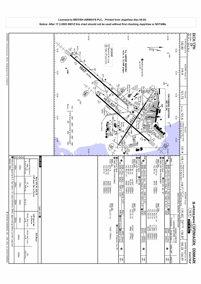
Elev8'Elev7'
Elev12'
Elev13'
Elev13'
Elev14'
Deicing Tw
y AControl
Tower
FO
R P
ARKIN
G P
OSIT
IONS
SEE 1
0-9
A
Operators applying U
.S. Ops Specs: C
L required below 300m
; approved guidance system required
below 150m
.
LVP m
ust b
ein
Forc
e
11,811'11,483'11,073'10,646'
9514'
(3600m)
(3500m)
(3375m)
(3245m)
(2900m)
9186'8842'8153'5906'
(2800m)
(2695m)
(2485m)
(1800m)
10,827'10,515'
9170'6365'
(3300m)
(3205m)
(2795m)
(1940m)
10,827'9088'
(3300m)
(2770m)
117'
VO
R
A
BC
D
K
V2
FBC
I
A
A5
B
BB4
K1
K2KK
3
F1
F2
E1G
2
N1
N1
N2
N2
A
76'
A
144'
125'
A6
A7
U
D
A1
A2
A3
A4
162'
AIS
N1
A
A
A9
A8
E3B1 B
2
B3
B5
V
T
T
E2
C
GG
Apt Elev
COPEN
HAGEN
, DEN
MARK
KA
STRUP Tow
erKA
STRUP D
eparture (R)
120.25 124.97118.57
E4
| JEPPESEN
SAN
DERSO
N, IN
C., 1998, 2004. A
LL RIGHTS RESERV
ED.
1
RVR
RVR
8904'8748'
2714m2666m
TAKE-O
FF RUN
AVA
ILABLE
TAKE-O
FF
ABCD
RCLM
(DA
Y only)
250m
300m
400m
500m
NIL
(DA
Y only)
1
RCLM
(DA
Y only)
RL & C
L
200m
250m
& m
ult. RVR req
125m
150m
LVP m
ust b
e in
Forc
e
or RLor RL
All R
wys
& m
ult. RVR req
150m
200m
RL, CL
HIRL, C
LA
pproved Operators
Rw
y 0
4L/
R, 2
2L/
R
RWY 04L:
RWY 22R:
HIRL
HIRL
(3.0^)RV
RRV
R(3.0^)
6824'
6923'2080m
2110m
REIL7858'23
95m
TAKE-O
FF RUN
AVA
ILABLE
RWY 12:
RWY 30:
7759'(2365m
)
Includes Stopway rw
y 30.
Antiskid layer
(3.0^)RV
RRV
R(3.0^)
9787'9774'
2983
m2979m
TDZ
RWY 04R:
TAKE-O
FF RUN
AVA
ILABLE
RWY 22L:
HIRL
CL
(3.0^)TD
ZHIRL
CL
(3.0^)REIL
U
V1
A11
A12
A10
(60m)
(60m)
(15m)
(15m)
HIRL
HIRL
(30m
)
(30m
)
(30m
)
(30m
)
01^E
55-3655-36
55-37
55-3855-38
12-36
12-36
12-37
12-37
12-38
12-38
12-39
12-39
12-40
12-40
CL
CL (15m
)
(15m)
HST-B
4
HST-E3, A
6, A7
D-A
TIS Departure
122.85KA
STRUP Tow
er (C)
119.9*G
round
121.72
9843'4216'
(3000m)
(1285m)
Deicing Tw
y V
Deicing Tw
y B
Com
passbase
SAS
Com
muter
A11
164'
Mobile obstacles
up to 82'.
G3 G4
G5G
1
G6
242'
119.35A
cft onm
aneuvering areaD
epartingacft
Antiskid layer.
Antiskid layer.
118.7118.1
Ground
121.6121.9
Arrival
Fromtw
y A10 int
twy E4 int
Fromtw
y A1/E1 int
twy A
2 inttw
y A3 int
twy A
4 inttw
y A5 int
FromFrom
FromFrom
twy B
1 inttw
y B2 int
twy B
3 inttw
y B4/C
int
twy V
1 inttw
y V2 int
posn Xtw
y K2 int
twy K
3 inttw
y D int
twy G
1 int
X
12 NO
V 04
.Eff.25.Nov.
Area
South
Com
munications. N
otes. Holding position w
ithdrawn.
Departure A
reaSouth &
Apron East
Test site 6
Departure except A
reaSouth &
Apron East
For A
IRPO
RT B
RIE
FIN
G
refe
r to 1
0-A
BP p
ages
LEGEN
DRem
ote de-icingTake-off position
X
10
10
10
ARP
04R040^
22L220^
10,827'3300m
04L040^
22R220^
12122^
30302^
7759'2365m
17'
KA
STRUP
10-9
3000m
9843'1870'570m Stopw
ay
1
Stopway
300m
984'
N55 37.1 E012 39.4
3
CHA
NG
ES:
45m148'
04L
22R
AD
DITIO
NA
L RUN
WA
Y IN
FORM
ATIO
N
ThresholdLA
ND
ING
BEY
ON
DUSA
BLE LEN
GTH
S
WID
THTA
KE-O
FFG
lide Slope
13
1230
45m148'
HIA
LSPA
PI-RHIA
LSPA
PI-L8
98
7
798
46
45m148'
04R
22L
HIA
LSPA
PI-L6
PAPI-L
4
PAPI-L
HIA
LSPA
PI-R
Feet
Meters
00
1000
1000
20003000
40005000
1500500
JEPPESEN
.JAR-OPS.
2
25
5
EKCH/C
PH
HIA
LS-II
HIA
LS-II
RWY
Licensed to BRITISH AIRWAYS PLC, . Printed from JeppView disc 04-05.
Notice: After 17.3.2005 0901Z this chart should not be used without first checking JeppView or NOTAMs.

DEIC
ING
TW
Y A
APRO
NW
EST
Control
Tower
A17
NO
ENTRY
AB
E1
C
K2
K3
K1
G2
F2
F1
RII
K
J
N1
12-37.9
G131
G132
G133
G134
A1
A2
A3
A4
12-38.112-38
12-38.212-38.3
12-38.4
12-3812-39
12-37.912-38.1
12-38.212-38.3
12-38.412-38.5
12-38.612-38.7
12-38.812-39.1
12-39.212-39.3
12-39.412-39.5
12-39.712-39.8
12-39.912-40
12-37.8
12-37.8
A23A
22A
21
A50
55-37
55-37.1
55-36.9
55-37.2
55-37.7
55-36.8
55-37.8
L
K
G
N1
B5
A5
55-37.9
G135
| JEPPESEN
SAN
DERSO
N, IN
C., 1998, 2004. A
LL RIGHTS RESERV
ED.
A25
W1
EKCH/C
PH
F1
RIRIII
F3
Z4
(NX)
J
TERM
INA
L 1
TEST
SIT
E4
AREA
SO
UTH
12-40.212-40.3
55-36.8
G136
G137
(GX)
G5
G1
G4
G3
SA
SCO
MM
UTER
DEIC
ING
TW
Y B
APRO
N
NO
RTH
DEIC
ING
TW
Y V
A7
A4A
9
A6
A8
B2
B3
B4
B5
B6
B7
B8
B9B
15B19
C38
C34
C35
C39
G110G
111 G112
G113 G
114G
123G
124G
125G
126G
127G
128
RWY 12/30
RWY 04R/22L
PIER C
PIER B
PIER A
A
A
B
BC
D
I
F
G129
G130
D
12-3912-38.5
12-38.612-38.8
12-38.912-39.1
12-38.7
AIS
D
C10
C26
C28
C30
C32
C36
C40
C23
C29
C33
C37C
43C45
C47
B17
B16
B10
A11
A12
A14
A15
A16
A20A
19 A18
C49
55-37.3
L
Z
Z
Z
Z
Y
Y
Y
Y
M
A
P
F
D
M
PQQ
B
G
C
A
G120
G121
G122
A
G6
TERM
INA
L 2
APRO
NEA
ST
V2
V1
U
T
12-39.212-39.3
12-39.412-40
12-40.112-40.2
12-40.3
55-37.4
55-37.5
55-37.6
55-37.7
55-37.8
B R R
VV
T
U
T
WW
12-39.512-39.6
12-39.812-39.9
55-37.9
SS
D1
D2
D3
D4
E78E77
E76
E75E74
E72E71
E70
F86F85
F84F83
F82
F97F95
F93F91
F98F96
F94F92
F90
H103
H102
H101
H100 H
104H105
H106
H107
12 NO
V 04
.Eff.25.Nov.
TERM
INA
L 3
HA
NG
AR
AREA
NO
RTH
TEST
SIT
E2
E60
NIG
HT
STOP
A26
A27
A28
A30
A31
A32
A33
A34Stands. A
pron designations. Note. H
olding positions.
Parking area(N
X)
Z4
CHA
NG
ES:
ARP
10-9ACOPEN
HAGEN
, DEN
MARK
KA
STRUP
JEPPESEN
LEGEN
DRI
F90
F83
Limit of A
pronControl C
ompetence
pow
ered turn-out
Nose-in Stand
Nose-in Stand w
ith
Start-up position
requiredM
arshaller guidance
Remote de-icing
Licensed to BRITISH AIRWAYS PLC, . Printed from JeppView disc 04-05.
Notice: After 17.3.2005 0901Z this chart should not be used without first checking JeppView or NOTAMs.

| JEPPESEN SANDERSON, INC., 1998, 2004. ALL RIGHTS RESERVED.
EKCH/CPH12 NOV 04 .Eff.25.Nov.
COORDINATES COORDINATES
INS COORDINATES
STAND No. STAND No.
APRON N
APRON W
APRON E
COPENHAGEN, DENMARKKASTRUP10-9B
CHANGES:
JEPPESEN
Stands. Coordinates.
G110, G111G112, G113
G114G120 thru G123
G124
G125G126 thru G131G132 thru G137
R I, R IIR IIIW1
N55 37.1 E012 39.9N55 37.2 E012 40.0N55 37.2 E012 40.1N55 37.2 E012 40.2N55 37.2 E012 40.3
N55 37.2 E012 40.2N55 37.1 E012 40.3N55 37.0 E012 40.3
N55 37.5 E012 37.9N55 37.4 E012 37.9N55 37.3 E012 37.8
A4, A6A7A8A9A11
A12, A14, A15
A16, A17A18 thru A21
A22, A23A25, A26
A27, A28A30, A31
A32 thru A34A50B2
B3B4B5B6B7
B8, B9B10
B15 thru B19C10C23
C26, C28C29C30C32C33
C34C35C36C37C38
C39C40
C43, C45C47, C49
D1
D2 thru D4E60
E70, E71E72 thru E74
E75, E76
E77E78
F82, F83F84
F85, F86
H100 thru H103H104 thru H107F90 thru F93F94 thru F97
F98
N55 37.7 E012 38.5N55 37.7 E012 38.6N55 37.7 E012 38.5N55 37.7 E012 38.6N55 37.6 E012 38.6
N55 37.6 E012 38.5N55 37.6 E012 38.4N55 37.7 E012 38.4N55 37.7 E012 38.3N55 37.7 E012 38.2
N55 37.7 E012 38.1N55 37.7 E012 38.0N55 37.7 E012 37.9N55 37.7 E012 38.3N55 37.7 E012 38.7
N55 37.7 E012 38.8N55 37.7 E012 38.7N55 37.6 E012 38.8N55 37.6 E012 38.7N55 37.6 E012 38.8
N55 37.6 E012 38.7N55 37.6 E012 38.6N55 37.5 E012 38.7N55 37.7 E012 38.9N55 37.6 E012 39.1
N55 37.6 E012 38.9N55 37.6 E012 39.0N55 37.6 E012 38.9N55 37.5 E012 38.9N55 37.5 E012 39.0
N55 37.5 E012 38.9N55 37.5 E012 39.0N55 37.5 E012 38.9N55 37.5 E012 39.0N55 37.5 E012 38.9
N55 37.5 E012 39.0N55 37.5 E012 38.9N55 37.5 E012 39.0N55 37.4 E012 39.0N55 37.6 E012 39.1
N55 37.6 E012 39.2N55 37.6 E012 39.8N55 37.6 E012 39.7N55 37.7 E012 39.7N55 37.7 E012 39.8
N55 37.7 E012 39.9N55 37.8 E012 39.9N55 37.5 E012 39.5N55 37.5 E012 39.4N55 37.5 E012 39.3
N55 37.5 E012 39.6N55 37.6 E012 39.6N55 37.4 E012 39.5N55 37.4 E012 39.4N55 37.4 E012 39.3
Licensed to BRITISH AIRWAYS PLC, . Printed from JeppView disc 04-05.
Notice: After 17.3.2005 0901Z this chart should not be used without first checking JeppView or NOTAMs.

EKCH/CPH
W
SS
V
| JEPPESEN SANDERSON, INC., 1998, 2004. ALL RIGHTS RESERVED.
E3
E2
L
E4
B3
A1
A2
A4
A3
B2
B1
Q
MY
P
Y
R R
A9
A10
A11
A12
G
G
G6
12 NOV 04 .Eff.25.Nov.
Taxi routings. Holding posn withdrawn.
DEIC
ING
TW
Y B
DEIC
ING
TW
Y V
V2
KASTRUPCOPENHAGEN, DENMARK
10-9C
TAXI
ROUTI
NG
S
N1 N
1 N1
N2
22L
30
T
T
V1
CHANGES:
JEPPESEN
Con
trol
Tow
er
APRO
NW
EST
DEIC
ING
TW
Y A
PIER C
AC
B
B4
B
FF2
D
04R
22R
12
N2
F3
B
C
DC
E1
A6
A
A
A5
B
B5
D
A8
A
Z
AZ
F1
K
K3
K2
K
PIERB
04L
A
A7
LEG
END
Taxi
rout
e
Rem
ote
de-i
cing
MD
11 n
ot a
utho
rize
dTa
xiro
ute
AN
22 &
FO
R A
330-2
00/-3
00,
A340-2
00/-3
00,
AN22,
B747,
B767-4
00,
B777-2
00,
DC-1
0,
IL86,
IL96-3
00,
L1011 &
MD11
N1
G2I
APRO
NE
G3
G5
G4
G1
B
NA
PRO
N
TEST S
ITE 6
TEST
SIT
E 4
Left
tur
n fr
om T
WY A
to
TWY F
and
rig
ht t
urn
from
TWY F
to
TWY A
not
per
mit
ted.
Left
tur
n fr
om T
WY F
2 to
RW
Y 1
2/30
and
rig
ht t
urn
from
RWY 1
2/30
to
TWY F
2 no
t pe
rmit
ted.
Pass
age
betw
een
RWY 1
2/30
and
TW
Y A
and
bet
wee
nRW
Y 1
2/30
and
TW
Y F
not
per
mit
ted.
Pass
age
betw
een
TWY F
2 an
d TW
Y A
not
per
mit
ted.
Pass
age
betw
een
TWY D
and
TW
Y A
1 no
t pe
rmit
ted.
Pass
age
betw
een
TWY A
1 an
d TW
Y E
1 no
t pe
rmit
ted.
Pass
age
betw
een
RWY 1
2/30
and
Apr
on N
orth
via
TWY D
not
per
mit
ted.
Pass
age
betw
een
RWY 3
0 an
d A
PRO
N N
via
TW
Y B
not
per
mit
ted.
Pass
age
betw
een
RWY 1
2 an
d TW
Y B
not
per
mit
ted.
Pass
age
betw
een
RWY 0
4R/2
2L a
nd T
WY I
not
per
mit
ted.
Left
tur
n fr
om T
WY V
2 to
RW
Y 0
4R/2
2L a
nd r
ight
tur
n fr
omRW
Y 0
4R/2
2L t
o TW
Y V
2 no
t pe
rmit
ted.
Licensed to BRITISH AIRWAYS PLC, . Printed from JeppView disc 04-05.
Notice: After 17.3.2005 0901Z this chart should not be used without first checking JeppView or NOTAMs.

EKCH/CPH
W
SS
V
E3
E2
L
E4
B3
A1
A2
A4
A3
B2
B1
Q
MY
P
Y
R R
A9
A10
A11
A12
G
G
G6
I
| JEPPESEN SANDERSON, INC., 2003, 2004. ALL RIGHTS RESERVED.
12 NOV 04 .Eff.25.Nov.
Chart reindexed. Holding posn withdrawn.
DEIC
ING
TW
Y B
DEIC
ING
TW
Y V
V2
KASTRUPCOPENHAGEN, DENMARK
10-9D
TAXI
ROUTI
NG
S
N1 N
1 N1 N
1
N2
22L
T
T
V1
CHANGES:
JEPPESEN
Con
trol
Tow
er
APRO
NW
EST
DEIC
ING
TW
Y A
PIER C
AC
B
B4
B
FF2
D
04R
22R
12
N2
F3
B
C
DC
E1
A6
A
A
A5
B
B5
D
A8
A
Z
AZ
NA
PRO
N
F1
K
K3
K2
K
PIERB
04L
A
A7
LEG
END
Taxi
rout
e
Rem
ote
de-i
cing
FO
R A
340-5
00/-6
00 &
B777-3
00
Taxi
rout
e fo
r de
icin
g on
ly
Pass
age
betw
een
TWY A
and
TW
Y F
2 no
t pe
rmit
ted.
Pass
age
betw
een
TWY E
1 an
d TW
Y C
not
per
mit
ted.
Pass
age
betw
een
TWY B
and
TW
Y Y
not
per
mit
ted.
Dei
cing
can
tak
e pl
ace
at "
Dei
cing
TW
Y A
" o
nly.
30
G2
APRO
NE
G3
G5
G4
G1
B
TEST
SIT
E 4
TEST S
ITE 6
Licensed to BRITISH AIRWAYS PLC, . Printed from JeppView disc 04-05.
Notice: After 17.3.2005 0901Z this chart should not be used without first checking JeppView or NOTAMs.

EKCH/CPH
W
SS
V
E3
E2
L
E4
B3
A1
A2
A4
A3
B2
B1
Q
MY
P
Y
R R
A9
A10
A11
A12
G
G
G6
I
| JEPPESEN SANDERSON, INC., 2003, 2004. ALL RIGHTS RESERVED.
12 NOV 04 .Eff.25.Nov.
Chart reindexed. Taxi routings. Hldg posn withdrawn.
DEIC
ING
TW
Y B
DEIC
ING
TW
Y V
V2
KASTRUPCOPENHAGEN, DENMARK
TAXI
ROUTI
NG
S
N1 N
1 N1 N
1
N2
22L
T
T
V1
CHANGES:
JEPPESEN
Con
trol
Tow
er
APRO
NW
EST
DEIC
ING
TW
Y A
PIER C
AC
B
B4
B
FF2
D
04R
22R
12
N2
F3
B
C
DC
E1
A6
A
A
A5
B
B5
D
A8
A
Z
AZ
NA
PRO
N
F1
K
K3
K2
K
PIERB
04L
A
A7
LEG
END
Taxi
rout
e
Rem
ote
de-i
cing
Taxi
rout
e A
N 2
25
AN 1
24,
AN 2
25 &
C5/L5
00 G
ALA
XY
not
auth
oriz
ed
Taxi
rout
e A
N 1
24 &
not
auth
oriz
edC5/
L500
GA
LAXY
Stan
dsR
II
R I
R II
R II
I
30
G2
APRO
NE
G3
G5
G4
G1
B
10-9E
TEST
SIT
E 4
TEST S
ITE 6
Left
tur
n fr
om T
WY F
2 to
RW
Y 1
2/30
and
rig
ht t
urn
from
RWY 1
2/30
to
TWY F
2 no
t pe
rmit
ted.
Left
tur
n fr
om T
WY B
to
RWY 1
2/30
and
rig
ht t
urn
from
RWY 1
2/30
to
TWY B
not
per
mit
ted.
Dur
ing
taxi
adj
acen
t TW
Y s
hall
be
kept
fre
e of
air
craf
t.D
urin
g ta
xiin
g an
d pa
rkin
g m
arsh
alle
r as
sist
ance
is
man
dato
ry.
Dei
cing
can
tak
e pl
ace
at "
Dei
cing
TW
Y A
" o
nly.
AN
124
& C
5/L5
00 G
ALA
XY:
Pass
age
betw
een
RWY 0
4R/2
2L a
nd T
WY I
not
per
mit
ted.
Left
tur
n fr
om T
WY V
2 to
RW
Y 0
4R/2
2L a
nd r
ight
tur
n fr
omRW
Y 0
4R/2
2L t
o TW
Y V
2 no
t pe
rmit
ted.
AN
225
:D
urin
g pa
ssag
e of
sta
nds
R I,
R I
I an
d R
III
stan
ds s
hall
be
kept
fre
e of
air
craf
t.
Licensed to BRITISH AIRWAYS PLC, . Printed from JeppView disc 04-05.
Notice: After 17.3.2005 0901Z this chart should not be used without first checking JeppView or NOTAMs.

| JEPPESEN SANDERSON, INC., 1998, 2004. ALL RIGHTS RESERVED.
12 NOV 04 .Eff.25.Nov.
EKCH/CPH
Check for correct acft type on upper display.Adjust according to indications ofINOGON display.Slow down and stop according toclosing-rate Indicator on display.Display automatically shut down after some seconds.
Check for correct acft type on upper display.Adjust according to horizontal red arrows on display.Slow down and stop as indicated by vertical closing-rate Indicator.Display automatically shut down after a short time or when bridge autolevel is turned on. Display will remain in operation in case the acft has overshot parking position.
COPENHAGEN, DENMARKKASTRUP10-9F
DOCKING GUIDANCE SYSTEMS
CHANGES:
JEPPESEN
GENERALSome stands are equipped with AGNIS and PAPA. Exceptions are listed below: APIS: SAFEDOCK: Center-line withyellow stop marking: Marshaller compulsory:
Stands A4, A6 thru A9, A11, A12, A14 thru A17, B3, B5, B7, B9,B15 thru B17, B19, C10, C23, C28, C29, C33 thru C39 and D4. Stands A18 thru A23, B10, C26, C30, C32, C40 and D1 thru D3,H102 and H105. Stands A25 thru A28, A50, E76 thru E78, F90 thru F98, G110 thru G114, G120 thru G137, H100, H101, H103, H104, H106, H107 and W1. Stands E60, RI , RII and RIII.
AGNIS - Azimuth Guidance Nose-In System
RED REDGREEN GREENGREEN GREEN
AGNIS Indications:
Adjust RIGHTtowards GREEN towards GREEN
Adjust LEFTOK
AGNIS must be used from left-hand cockpit seat only.The seat must be in neutral position.
PAPA - Parallax Aircraft Parking Aid
Stop when the appropriate acfttype marking on the PAPA frontplate is aligned with the rearlight-tube.When AGNIS/PAPA are switchedoff, stand is not cleared for entry.
FLUORESCENTTUBE
APIS - Aircraft Parking and Information System
INOGON
Closing-rate Indicator
SAFEDOCK
Docking guidance systems.
Closing-rate Indicator
Azimuth Indicator
SLOT
B 747
OK
-400B 747
A300 MD80
OTHERACFT
Licensed to BRITISH AIRWAYS PLC, . Printed from JeppView disc 04-05.
Notice: After 17.3.2005 0901Z this chart should not be used without first checking JeppView or NOTAMs.

SWED
EN
DEN
MARK
EK(D)-76
EK(P)-1
ES(R)-36 A
ES(R)-36 B
Copenhagen(Roskilde)
D5.0D2.0
D0.5D9.3 LOC
LOC
CH
CH CH
CH
RVR RVR600m 1000m
RVR
RVR
RVR 1400m
1000m
900mRVR
RVR
RVR
1500m
1800m
2000m
.JAR-OPS.
VORKAS D17.0
204^
12-10 12-30 12-40 12-50
13-00
55-20
55-30
55-40
530'
837'
461' 510'
454'
502'
349^
MISSED APCH:
BRIE
FIN
G S
TRIP
TM
Gnd speed-Kts
05
510
1520
EKCHKASTRUP
COPENHAGEN, DENMARK11-1
ATIS Arrival
122.75 118.45
KASTRUP Arrival (APP) COPENHAGEN Approach (R)
119.8 119.1
KASTRUP Final (APP) KASTRUP Tower
118.1 119.9 119.35LOCCH
*110.5
FinalApch Crs
040^
GS
1600'(1587')
ILSDA(H)
Refer toMinimums
Apt Elev
RWY
17'
13'
70 90 100 120 140 160
040^
220^
ILS DME Rwy 04L
D5.0 CH
Climb STRAIGHT AHEAD to 500', then turn LEFTonto 349^ climbing to 3000' and inform ATC.
HIALS
PAPI
500'
LT
349^ 3000'
27 OCT 00
| JEPPESEN SANDERSON, INC., 2000. ALL RIGHTS RESERVED.
.Eff.2.Nov.
D112.5 KASKASTRUP
040^
K A SC H
D0.5
D2.0
D5.0
SOUTHWEST HOLDING
040^ *110.5 CH
2000
ILS DME
BASLOKAS
220^/10.0N55 27.9 E012 25.2
D9.3
MAX:
CH
CH
CH
CH
ILS GS 3.00^ or862755647539485377
STRAIGHT-IN LANDING RWY
A
B
C
D
FULL ALS out ALS out MDA(H)
CIRCLE-TO-LANDILS LOC (GS out)
MaxKts100
135
180
205
04L
1500m
1600m
2400m
3600m
DA(H)MDA(H) (417')
(463')
(503')
(763')1
430'
480'520'780'
1
centerline Rwy 12
1 780'(763')
B:227'(214') D:246'(233')A:215'(202') C:235'(222')
PA
NS O
PS 4
LOC
ALTITUDE (HAT)
RWY 04L
040^
1600'610'(1587')(597')
GS1600'(1587')
OCA(H) RWY 04LILS A: 215' (202')
(214')(222')(233')(417')430'
D: 246'235'227'B:
C:
GS out
TCH 49'3.0 1.5 0.3
13'
2.0660' (647')
3.0980' (967')
4.01300' (1287')
6.01940' (1927')
7.02260' (2247')(GS out)
8.02580' (2567')
3000'(2987')
4.3
Alt Set: hPa Trans level: By ATC Trans alt: 5000'(4987')Rwy Elev: 0 hPa
LOC Descent Gradient 5.2%
between centerline Rwy 22R &
MAP at D0.5 CH
CH DME
VIS
KAS D17.0
420'
554'
1083'Hazard Beacon
470'
469'
669'
Not approved North of Apt
CHANGES:
JEPPESEN
074^
189^
2100'
1500'
1700'
309^
MSA KAS VORDependent parallel apch auth with rwy 04R. For further instructions refer to 10-9.
D10.0 KAS
R-219/D5.0 KAS
Procedure. New chart format.
204^
Licensed to BRITISH AIRWAYS PLC, . Printed from JeppView disc 04-05.
Notice: After 17.3.2005 0901Z this chart should not be used without first checking JeppView or NOTAMs.
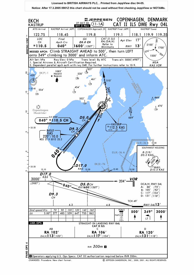
SWED
EN
DEN
MARK
EK(D)-76
EK(P)-1
ES(R)-36 A
ES(R)-36 B
Copenhagen(Roskilde)
204^
12-10 12-30 12-40 12-50
13-00
55-20
55-30
55-40
530'
837'
461' 510'
454'
502'
349^
MISSED APCH:
BRIE
FIN
G S
TRIP
TM
Gnd speed-Kts
05
510
1520
EKCHKASTRUP
COPENHAGEN, DENMARK
ATIS Arrival
122.75 118.45
KASTRUP Arrival (APP) COPENHAGEN Approach (R)
119.8 119.1
KASTRUP Final (APP) KASTRUP Tower
118.1 119.9 119.35LOCCH
*110.5
FinalApch Crs
040^
GS
1600'(1587')Refer to
Minimums
Apt Elev
RWY
17'
13'
70 90 100 120 140 160
040^
220^
D5.0 CH
Climb STRAIGHT AHEAD to 500', then turn LEFTonto 349^ climbing to 3000' and inform ATC.
HIALS
PAPI
500'
LT
11-1A CAT II ILS DME Rwy 04L
1
CAT II ILSSTRAIGHT-IN LANDING RWY 04L
RVR 300m
DA(H)113'(100') DA(H)117'(104') DA(H)131'(118')RA 102' RA 106' RA 120'
AB C D
.JAR-OPS.
1
Operators applying U.S. Ops Specs: CAT III authorization required below RVR 350m.
D5.0
D9.3
CH
CH
VORKAS
D17.0
CAT II ILS
349^ 3000'
RA/DA(H)
27 OCT 00
| JEPPESEN SANDERSON, INC., 2000, 2001. ALL RIGHTS RESERVED.
.Eff.2.Nov.
D112.5 KASKASTRUP
040^
K A SC H D5.0
SOUTHWEST HOLDING
040^ *110.5 CH
2000
ILS DME
BASLOKAS
220^/10.0N55 27.9 E012 25.2
D9.3
MAX:
CH
CH
3.00^ 862755647539485377
PA
NS O
PS 4
Alt Set: hPa Trans level: By ATC Trans alt: 5000'(4987')Rwy Elev: 0 hPa
KAS D17.0
420'
554'
1083'Hazard Beacon
470'
469'
669'
CHANGES:
JEPPESEN
074^
189^
2100'
1500'
1700'
309^
D10.0 KAS
R-219/D5.0 KAS
2. Dependent parallel apch auth with rwy 04R. For further instructions refer to 10-9.MSA
KAS VOR
GS
RWY 04L
040^ GS1600'(1587')
TCH 49'4.8 13'
3000'(2987')
4.3
A:B:C:D: 131'
117'105'88' (75')
(92')(104')(118')
OCA(H) RWY 04L
1. Special Aircrew & Aircraft Certification Required.
Procedure. New chart format.
204^
Licensed to BRITISH AIRWAYS PLC, . Printed from JeppView disc 04-05.
Notice: After 17.3.2005 0901Z this chart should not be used without first checking JeppView or NOTAMs.

SWED
EN
DEN
MARK
EK(D)-76
EK(P)-1
ES(R)-36 A
ES(R)-36 B
Copenhagen(Roskilde)
D5.0 KAS
D8.1KAS
D8.1
D5.0
OM
VOR/MM
KAS
KAS KAS D17.0
203^
KASD17.0
203^
12-10 12-30 12-40 12-50
13-00
55-20
55-30
55-40
RVR
RVR
600m
1000m
RVR
RVR
RVR 1400m
1000m
900mRVR
RVR
RVR
1500m
1800m
2000m
.JAR-OPS.
| JEPPESEN SANDERSON, INC., 2000. ALL RIGHTS RESERVED.
MISSED APCH:BRIE
FIN
G S
TRIP
TM
Gnd speed-Kts
05
510
1520
EKCHKASTRUP
COPENHAGEN, DENMARKILS Rwy 04R11-2
ATIS Arrival
122.75 118.45
KASTRUP Arrival (APP) COPENHAGEN Approach (R)
119.8 119.1
KASTRUP Final (APP) KASTRUP Tower
118.1 119.9 119.35LOCNE
*109.3
FinalApch Crs
040^
GSOM
1020'(1008')
ILSDA(H)
Refer toMinimums
Apt Elev
RWY
17'
12'
Climb STRAIGHT AHEAD to 3000' and inform ATC.
70 90 100 120 140 160
RVR 550m
HIALS3000'
PAPI
040^
220^
27 OCT 00.Eff.2.Nov.
D112.5 KASKASTRUP
K A S
040^
OMMM
0
ILS A:
430'D:
B:C:
GS out
OCA(H) RWY 04R
RWY 04R 12'
180'192'203'215'
(418')(203')(191')(180')(168')
TCH 57'2.0
LOC(GS out) ALTITUDE (HAT)
KAS DME 7.0 6.02640'(2628') 2320'(2308')
4.0 3.0 2.0 1.01680' 1360'(1348') 1040'(1028') 720'(708')
040^
C
1.03.0
M
GS (1008')
2000'(1988')
(2988')3000'
LOC1020'(1008')
GS (1988')
(1668')
3.03.1
LOC
ILS
040^ *109.3 NEN E
420'530'
837'
461' 510'
554'
454'
502'
1083'Hazard Beacon
470'
469'
669'
ILS GS 3.00^ or862755647539485377
STRAIGHT-IN LANDING RWY
A
B
C
D
FULL ALS out ALS out MDA(H)
CIRCLE-TO-LANDILS LOC (GS out)
MaxKts100
135
180
205
04R
1500m
1600m
2400m
3600m
DA(H)MDA(H) (418')
(463')
(503')
(763')1
430'
480'520'
780'
1
centerline Rwy 12
1 780'(763')
D:215'(203')212'(200')
PA
NS O
PS 4
Alt Set: hPa Trans level: By ATC Trans alt: 5000'(4988')Rwy Elev: 0 hPa
LOC Descent Gradient 5.2%
between centerline Rwy 22R &
VIS
Not approved North of Apt
CHANGES:
JEPPESEN
074^
189^
2100'
1500'
1700'
309^
MSA KAS VORDependent parallel apch auth with rwy 04L. For further instructions refer to 10-9.
MAP at MM/VOR
ABC:
BASLOKAS
220^/10.0N55 27.9 E012 25.2
SOUTHWEST HOLDING
2000
MAX:D10.0 KAS
R-219/D5.0 KAS
1020'
2000'
Procedure. New chart format.
GS 380'(368')
Licensed to BRITISH AIRWAYS PLC, . Printed from JeppView disc 04-05.
Notice: After 17.3.2005 0901Z this chart should not be used without first checking JeppView or NOTAMs.

SW
EDEN
DENM
ARK
Vaerlose
Copenhagen(Roskilde)
EK(P)-1
292^
D5.0
D9.3D2.5
LOC
LOC
KA
KA KA
12-10 12-20 12-30 12-40 12-50 13-00
55-30
55-40
55-50
RVRRVR
600m1000m
RVR
RVR
RVR 1400m
1000m
900mRVR
RVR
RVR
1500m
1800m
2000m
.JAR-OPS.
| JEPPESEN SANDERSON, INC., 2000. ALL RIGHTS RESERVED.
MISSED APCH:
BRIE
FIN
G S
TRIP
TM
Gnd speed-Kts
05
510
1520
EKCHKASTRUP
COPENHAGEN, DENMARK11-3
ATIS Arrival
122.75 118.45
KASTRUP Arrival (APP) COPENHAGEN Approach (R)
119.8 119.1
KASTRUP Final (APP) KASTRUP Tower
118.1 119.9 119.35LOCKA
*109.9
FinalApch Crs
122^
GS
1600'(1587')
ILSDA(H)
Refer toMinimums
Apt Elev
RWY
17'
13'
Climb STRAIGHT AHEAD to 3000' and inform ATC.
70 90 100 120 140 160
ILS DME Rwy 12
D5.0 KA
RVR 550m
HIALS3000'
REIL PAPI
135^
315^
27 OCT 00.Eff.2.Nov.
D112.5 KASKASTRUP
K A S
122^
D0.5
D5.0
D2.5
D9.3
K AILS DME
122^ *109.9 KA
D17.0KAS
KA
KA
KA
KA
LOC(GS out) ALTITUDE (HAT)
0.3 13'RWY 12
TCH 49'
OCA(H) RWY 12208'A:ILS
B: 220'228'C:
D: 239'430'GS out (417')
(226')(215')
(195')(207')
122^D0.5
2.02.5
GS
650'(637')
3000'(2987')
1600'
1600'
(1587')
(1587')
4.3
2.0650' (637')
3.0970' (957')
4.01290'(1277')
6.01930'(1917')
7.02250'(2237')
8.02570'(2557')
KA DME
KA
D17.0KAS
420' 530'
837'
461' 510'
554'
454'
502'
1083'Hazard Beacon
470'
469'
669'
ILS GS 3.00^ or862755647539485377
STRAIGHT-IN LANDING RWY
A
B
C
D
FULL ALS out ALS out MDA(H)
CIRCLE-TO-LANDILS LOC (GS out)
MaxKts100
135
180
205
1500m
1600m
2400m
3600m
DA(H)MDA(H) (417')
(463')
(503')
(763')1
430'
480'520'
780'
1
centerline Rwy 12
1 780'(763')
B:220'(207') D:239'(226')A:213'(200') C:228'(215')
PA
NS O
PS 4
Alt Set: hPa Trans level: By ATC Trans alt: 5000'(4987')Rwy Elev: 0 hPa
LOC Descent Gradient 5.2%
between centerline Rwy 22R &
VIS
Not approved North of Apt
CHANGES:
JEPPESEN
074^
189^
2100'
1500'
1700'
309^
MSA KAS VOR
MAP at D0.5 KA
12
NORTHWEST HOLDING
R-314/D9.0 KAS3000
Chart reindexed. Procedure. New chart format.
VOR292^
Licensed to BRITISH AIRWAYS PLC, . Printed from JeppView disc 04-05.
Notice: After 17.3.2005 0901Z this chart should not be used without first checking JeppView or NOTAMs.

SWED
EN
DEN
MARKVaerlose
024^
55-30
55-40
55-50
OXS
D1.0 OXS
189^
LOC
VOR
12-20 12-30 12-40 12-50 13-00
13-10
RVR RVR550m 1000m
RVR
RVR
RVR 1400m
1000m
900mRVR
RVR
RVR
1500m
1800m
2000m
.JAR-OPS.
MISSED APCH:
BRIE
FIN
G S
TRIP
TM
Gnd speed-Kts
05
510
1520
EKCHKASTRUP
COPENHAGEN, DENMARK11-4
ATIS Arrival
122.75 118.45
KASTRUP Arrival (APP) COPENHAGEN Approach (R)
119.8 119.1
KASTRUP Final (APP) KASTRUP Tower
118.1 119.9 119.35LOC
*109.5
FinalApch Crs
220^
GS
1600'(1592')
ILSDA(H)
Apt Elev
RWY
17'
70 90 100 120 140 160
ILS DME Rwy 22L
OXS D5.0 OXS
8'208'(200')
climbing to 3000' and inform ATC.after OXS DME, whichever is later, then turn LEFT onto 189^
HIALS
PAPI
040^
220^
Climb STRAIGHT AHEAD to 500' or D1.0 OXS
Refer toMissed Apch
above
| JEPPESEN SANDERSON, INC., 2000. ALL RIGHTS RESERVED.
27 OCT 00.Eff.2.Nov.
D112.5 KASKASTRUP
K A S
220^
D0.5
D9.3
D5.0
OXS
OXS
KAS D17.0
530'
837'
461' 510'
454'
502'
470'
469'
669'
TCH 53'
RWY 22L 8'
OCA(H) RWY 22L(142')150'A:ILS
B:
D:GS out
C: 170'181'400' (392')
(173')(162')(152')160'
0.3
(1492')1500'
220^
4.5
LOC(GS out) ALTITUDE (HAT)
2.0 3.0 4.0 5.0 6.0 7.0650'(642') 970'(962') 1290'(1282') 1610'(1602') 1930'(1922') 2250'(2242')
4.3
3000'(2992')
D0.5 D9.3
OXS DME
OXS OXS
KAS D17.0
1600'GS (1592')D5.0OXS
ILS GS 3.00^ or862755647539485377
STRAIGHT-IN LANDING RWY
A
B
C
D
FULL ALS out ALS out MDA(H)
CIRCLE-TO-LANDILS LOC (GS out)
MaxKts100
135
180
205
22L
1500m
1600m
2400m
3600m
MDA(H) (392')
(463')
(503')
(763')1
400'
480'520'
780'
1
centerline Rwy 12
1 780'(763')
PA
NS O
PS 4
Alt Set: hPa Trans level: By ATC Trans alt: 5000'(4992')Rwy Elev: 0 hPa
LOC Descent Gradient 5.2%
between centerline Rwy 22R &
MAP at D0.5 OXS
VIS
Not approved North of Apt
CHANGES:
JEPPESEN
074^
189^
2100'
1500'
1700'
309^
Dependent parallel apch auth with rwy 22R. For further instructions refer to 10-9.MSA
KAS VOR
208'(200')DA(H)
KAS040^/13.0
N55 45.3 E012 52.0
LAMOX
ILS DME
220^ *109.5 OXSO X S
NORTHEAST HOLDING
2000
MAX:D13.0 KAS
R-039/D8.0 KAS
Chart reindexed. Procedure. New chart format.
024^
Licensed to BRITISH AIRWAYS PLC, . Printed from JeppView disc 04-05.
Notice: After 17.3.2005 0901Z this chart should not be used without first checking JeppView or NOTAMs.
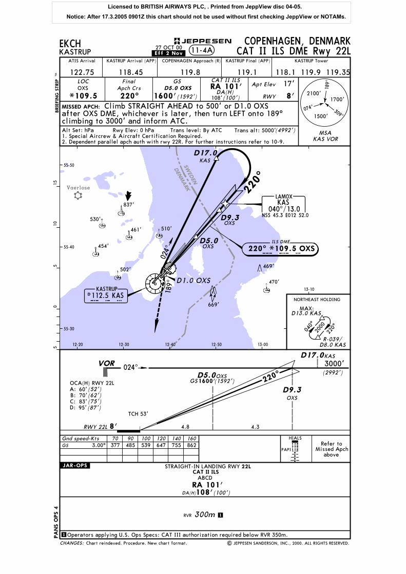
SWED
EN
DEN
MARKVaerlose
024^
55-30
55-40
55-50
OXS
D1.0 OXS
189^
VOR
12-20 12-30 12-40 12-50 13-00
13-10
MISSED APCH:
BRIE
FIN
G S
TRIP
TM0
55
1015
EKCHKASTRUP
COPENHAGEN, DENMARK
ATIS Arrival
122.75 118.45
KASTRUP Arrival (APP) COPENHAGEN Approach (R)
119.8 119.1
KASTRUP Final (APP) KASTRUP Tower
118.1 119.9 119.35LOC
*109.5
FinalApch Crs
220^
GS
1600'(1592')DA(H)
Apt Elev
RWY
17'OXS D5.0 OXS
8'108'(100')
climbing to 3000' and inform ATC.after OXS DME, whichever is later, then turn LEFT onto 189^
11-4A CAT II ILS DME Rwy 22L
CAT II ILSRA 101'
Gnd speed-Kts 70 90 100 120 140 160
1
CAT II ILSSTRAIGHT-IN LANDING RWY 22L
RVR 300m
DA(H)108'(100')RA 101'
.JAR-OPS.
1
Operators applying U.S. Ops Specs: CAT III authorization required below RVR 350m.
ABCD
040^
220^
Climb STRAIGHT AHEAD to 500' or D1.0 OXS
HIALS
PAPIRefer to
Missed Apchabove
| JEPPESEN SANDERSON, INC., 2000. ALL RIGHTS RESERVED.
27 OCT 00.Eff.2.Nov.
D112.5 KASKASTRUP
K A S
220^
D9.3
D5.0
OXS
KAS D17.0
530'
837'
461' 510'
454'
502'
470'
469'
669'
1600'GS (1592')D5.0OXS
TCH 53'
RWY 22L 8'
OCA(H) RWY 22L(52')60'A:
B:
D:C: 83'
95'(87')(75')(62')70'
220^
4.8 4.3
3000'(2992')
D9.3OXS
KAS D17.0
Alt Set: hPa Trans level: By ATC Trans alt: 5000'(4992')Rwy Elev: 0 hPa
CHANGES:
JEPPESEN
074^
189^
2100'
1500'
1700'
309^
MSAKAS VOR2. Dependent parallel apch auth with rwy 22R. For further instructions refer to 10-9.
1. Special Aircrew & Aircraft Certification Required.
3.00^ 862755647539485377GS
PA
NS O
PS 4
ILS DME
220^ *109.5 OXSO X S
KAS040^/13.0
N55 45.3 E012 52.0
LAMOX
NORTHEAST HOLDING
2000
MAX:D13.0 KAS
R-039/D8.0 KAS
Chart reindexed. Procedure. New chart format.
024^
Licensed to BRITISH AIRWAYS PLC, . Printed from JeppView disc 04-05.
Notice: After 17.3.2005 0901Z this chart should not be used without first checking JeppView or NOTAMs.

SWED
EN
DEN
MARK
Vaerlose
D0.5 KLK
55-30
55-40
55-50
RVR
RVR
600m
1000m
RVR
RVR
RVR 1400m
1000m
900mRVR
RVR
RVR
1500m
1800m
2000m
.JAR-OPS.
| JEPPESEN SANDERSON, INC., 2000. ALL RIGHTS RESERVED.
MISSED APCH:BRIE
FIN
G S
TRIP
TM
Gnd speed-Kts
05
510
1520
EKCHKASTRUP
COPENHAGEN, DENMARK11-5
.Eff.2.Nov.27 OCT 00
ATIS Arrival
122.75 118.45
KASTRUP Arrival (APP) COPENHAGEN Approach (R)
119.8 119.1
KASTRUP Final (APP) KASTRUP Tower
118.1 119.9 119.35LOC
*110.9
FinalApch Crs
220^
GS
1600'(1586')
ILSDA(H)
Refer toMinimums
Apt Elev
RWY
17'
14'
Climb STRAIGHT AHEAD to 3000' and inform ATC.
70 90 100 120 140 160
ILS DME Rwy 22R
KLK
RVR 550m
3000'HIALS
REIL PAPI
D0.5 D9.3
LOC KLK KLK
D17.0KAS VOR
022^D5.0 KLK
12-20 12-30 12-40 12-50 13-00
13-10
040^
220^
D5.0 KLK
D112.5 KASKASTRUP
K A S
220^
D9.3
D5.0
KLK
KLK
KAS D17.0
530'
837'
461' 510'
454'
502'
1083'Hazard Beacon
470'
469'
669'
ILS GS 3.00^ or862755647539485377
STRAIGHT-IN LANDING RWY
A
B
C
D
FULL ALS out ALS out MDA(H)
CIRCLE-TO-LANDILS LOC (GS out)
MaxKts100
135
180
205
22R
1500m
1600m
2400m
3600m
DA(H)MDA(H) (386')
(463')
(503')
(763')1
400'
480'520'
780'
1
centerline Rwy 12
1 780'(763')
214' D:230'(216')C:220'(206')
PA
NS O
PS 4
Alt Set: hPa Trans level: By ATC Trans alt: 5000'(4986')Rwy Elev: 0 hPa
LOC Descent Gradient 5.2%
between centerline Rwy 22R &
MAP at D0.5 KLK
VIS
Not approved North of Apt
CHANGES:
JEPPESEN
Procedure. New chart format.
074^
189^
2100'
1500'
1700'
309^
MSA KAS VORDependent parallel apch auth with rwy 22L. For further instructions refer to 10-9.
AB: (200')
A:ILSB:
D:GS out
C:
400'
0.3
220^
4.5
LOC(GS out) ALTITUDE (HAT)
2.0 3.0 4.0
OCA(H) RWY 22R
RWY 22R 14'
TCH 47'
200'210'220'230'
(386')(216')(206')(196')(186')
1600'(1586')
650'(636') 970'(956') 1290'(1276')
4.3
3000'(2986')
6.01930'(1916')
7.02250'(2236')
8.02570'(2556')
KLK DME
1600'GS (1586')
ILS DME
KAS040^/13.0
N55 45.3 E012 52.0
LAMOX
220^ *110.9 KLKK L K
NORTHEAST HOLDING
2000
MAX:D13.0 KAS
R-039/D8.0 KAS
022^
Licensed to BRITISH AIRWAYS PLC, . Printed from JeppView disc 04-05.
Notice: After 17.3.2005 0901Z this chart should not be used without first checking JeppView or NOTAMs.

SWED
EN
DEN
MARK
ES(R)-36 A
ES(R)-36 B
D0.5OY
OY OY 130^
KAS
D0.5
D5.0
D9.3
LOC
OY
OY
OY
VOR KASD17.0
12-20 12-30 12-40 12-50 13-00 13-1055-20
55-30
55-40
RVR
RVR
550m
1000m
RVR
RVR
RVR 1400m
1000m
900mRVR
RVR
RVR
1500m
1800m
2000m
.JAR-OPS.
| JEPPESEN SANDERSON, INC., 2000. ALL RIGHTS RESERVED.
MISSED APCH:
BRIE
FIN
G S
TRIP
TM
Gnd speed-Kts
05
510
1520
EKCHKASTRUP
COPENHAGEN, DENMARK11-6
.Eff.2.Nov.27 OCT 00
ATIS Arrival
122.75 118.45
KASTRUP Arrival (APP) COPENHAGEN Approach (R)
119.8 119.1
KASTRUP Final (APP) KASTRUP Tower
118.1 119.9 119.35LOCOY
*108.9
FinalApch Crs
302^
GS
1600'(1592')
ILSDA(H)
Refer toMinimums
Apt Elev
RWY
17'
Climb STRAIGHT AHEAD to 3000' and inform ATC.
70 90 100 120 140 160
ILS DME Rwy 30
D5.0 OY
8'
RVR 600m
3000'PAPI
HIALS
D112.5 KASKASTRUP
K A SD5.0
302^
D9.3ILS DME
302^ *108.9 OYO Y
D17.0
1600'TCH 49'
0.3
LOC(GS out) ALTITUDE (HAT)
2.0650' 970'(642') (962')
GS 302^
4.5RWY 30 8'
ILS A:B:C:D:
GS out
OCA(H) RWY 30202'214'222'233'420' (412')
(225')(214')(206')(194')
(1592')
3.0 4.0 6.0 7.0 8.0
3000'(2992')
4.3
1930'(1922') 2250'(2242') 2570'(2562')1290'(1282')
1600'(1592')
OY DME
530'
837'
461' 510'
454'
502'
1083'Hazard Beacon
470'
427'443'
469'
669'
HazardBeacon
ILS GS 3.00^ or862755647539485377
STRAIGHT-IN LANDING RWY
A
B
C
D
FULL ALS out ALS out MDA(H)
CIRCLE-TO-LANDILS LOC (GS out)
MaxKts100
135
180
205
1500m
1600m
2400m
3600m
DA(H)MDA(H) (412')
(463')
(503')
(763')1
420'
480'520'
780'
1
centerline Rwy 12
1 780'(763')
B:214'(206') D:233'(225')A:208'(200') C:222'(214')
PA
NS O
PS 4
Alt Set: hPa Trans level: By ATC Trans alt: 5000'(4992')Rwy Elev: 0 hPa
LOC Descent Gradient 5.2%
between centerline Rwy 22R &
VIS
Not approved North of Apt
CHANGES:
JEPPESEN
Procedure. New chart format.
074^
189^
2100'
1500'
1700'
309^
MSA KAS VOR
30
MAP at D0.5 OY
130^
Licensed to BRITISH AIRWAYS PLC, . Printed from JeppView disc 04-05.
Notice: After 17.3.2005 0901Z this chart should not be used without first checking JeppView or NOTAMs.
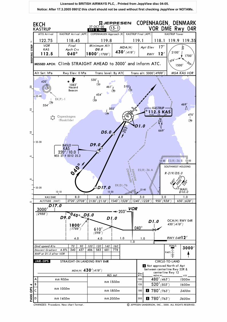
SW
EDEN
DENM
ARK
EK(P)-1
ES(R)-36 A
ES(R)-36 B
Copenhagen(Roskilde)
EK(D)-76
D1.0
D5.0
D9.0
D9.0D5.0
D1.0D1.0
D17.0
203^
203^
12-10 12-3012-40
12-50 13-00
55-20
55-30
55-40
D17.0
RVR
RVR
RVR 1400m
1000m
900mRVR
RVR
RVR
1500m
1800m
2000m
.JAR-OPS.
| JEPPESEN SANDERSON, INC., 2000. ALL RIGHTS RESERVED.
MISSED APCH:
BRIE
FIN
G S
TRIP
TM
Gnd speed-Kts
05
510
1520
EKCHKASTRUP
COPENHAGEN, DENMARK13-1
ATIS Arrival
122.75 118.45
KASTRUP Arrival (APP) COPENHAGEN Approach (R)
119.8 119.1
KASTRUP Final (APP) KASTRUP Tower
118.1 119.9 119.35VOR
112.5
FinalApch Crs
040^ 1800'(1788')
MDA(H) Apt Elev
RWY
17'
12'
Climb STRAIGHT AHEAD to 3000' and inform ATC.
70 90 100 120 140 160
VOR DME Rwy 04R
KASMinimum Alt
D5.0430'(418')
HIALS3000'
PAPI
040^
220^
27 OCT 00.Eff.2.Nov.
040^
D 112.5 KASKASTRUP
K A S
040^
1.0
VOR
430'(418')OCA(H) RWY 04R
0
RWY 04R 12'1.01.0
610'(598')
040^
3000'(2988')
4.04.0
1800'(1788')
ALTITUDE (HAT)
KAS DME 1.04.0 3.0 2.01540'(1528') 1240'(1228') 950'(938') 650'(638')
6.02130'(2118')
8.02720'(2708')
420'530'
461' 510'
554'
454'
502'
1083'Hazard Beacon
470'
469'
669'
778681583486437340
STRAIGHT-IN LANDING RWY
A
B
C
D
ALS out MDA(H)
CIRCLE-TO-LAND
MaxKts100
135
180
205
04R
1500m
1600m
2400m
3600m
MDA(H) (418')
(463')
(503')
(763')1
430'
480'520'
780'
1
centerline Rwy 12
1 780'(763')
PA
NS O
PS 4
Alt Set: hPa Trans level: By ATC Trans alt: 5000'(4988')Rwy Elev: 0 hPa
4.8%
between centerline Rwy 22R &
VIS
Not approved North of Apt
CHANGES:
JEPPESEN
074^
189^
2100'
1500'
1700'
309^
MSA KAS VOR
Descent Gradient
MAP at D1.0 after VOR
BASLOKAS
220^/10.0N55 27.9 E012 25.2
SOUTHWEST HOLDING
2000
MAX:
R-219/D5.0
D10.0
Procedure. New chart format.
Licensed to BRITISH AIRWAYS PLC, . Printed from JeppView disc 04-05.
Notice: After 17.3.2005 0901Z this chart should not be used without first checking JeppView or NOTAMs.
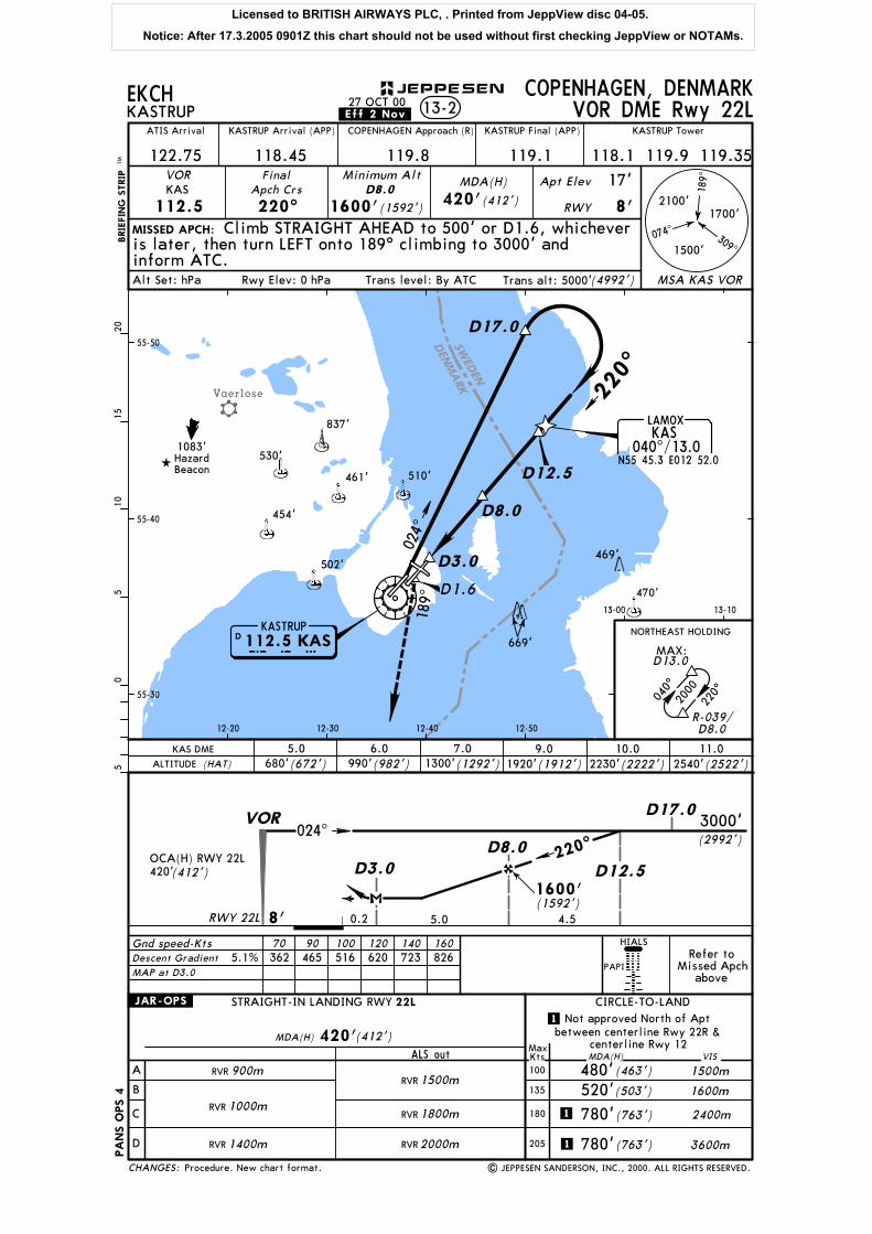
SWED
EN
DEN
MARK
Vaerlose
D8.0
D3.0
024^
55-30
55-40
55-50
189^
D3.0D8.0
D12.5
D17.0
12-20 12-30 12-40 12-50
13-00 13-10
RVR
RVR
RVR 1400m
1000m
900mRVR
RVR
RVR
1500m
1800m
2000m
.JAR-OPS.
| JEPPESEN SANDERSON, INC., 2000. ALL RIGHTS RESERVED.
MISSED APCH:
BRIE
FIN
G S
TRIP
TM
Gnd speed-Kts
05
510
1520
EKCHKASTRUP
COPENHAGEN, DENMARK13-2
.Eff.2.Nov.27 OCT 00
ATIS Arrival
122.75 118.45
KASTRUP Arrival (APP) COPENHAGEN Approach (R)
119.8 119.1
KASTRUP Final (APP) KASTRUP Tower
118.1 119.9 119.35VOR
112.5
FinalApch Crs
220^ 1600'(1592')
MDA(H) Apt Elev
RWY
17'
70 90 100 120 140 160
VOR DME Rwy 22L
KASMinimum Alt
D8.0420'(412') 8'
Climb STRAIGHT AHEAD to 500' or D1.6, whicheveris later, then turn LEFT onto 189^ climbing to 3000' andinform ATC.
D1.6
040^
220^
HIALS
PAPIRefer to
Missed Apchabove
220^
D12.5530'
837'
461' 510'
454'
502'
1083'Hazard Beacon
470'
469'
D17.0
669'
220^
RWY 22L 8'
420'(412')OCA(H) RWY 22L
VOR
0.2
ALTITUDE (HAT)
KAS DME 5.0 6.0 7.0680'(672') 990'(982') 1300'(1292')
3000'(2992')
4.55.0
9.0(1912')1920'
10.0(2222')2230'
11.02540'(2522')
1600'(1592')
826723620516465362
STRAIGHT-IN LANDING RWY
A
B
C
D
ALS out MDA(H)
CIRCLE-TO-LAND
MaxKts100
135
180
205
22L
1500m
1600m
2400m
3600m
MDA(H) (412')
(463')
(503')
(763')1
420'
480'520'
780'
1
centerline Rwy 12
1 780'(763')
PA
NS O
PS 4
Alt Set: hPa Trans level: By ATC Trans alt: 5000'(4992')Rwy Elev: 0 hPa
5.1%
between centerline Rwy 22R &
VIS
Not approved North of Apt
CHANGES:
JEPPESEN
Procedure. New chart format.
074^
189^
2100'
1500'
1700'
309^
MSA KAS VOR
Descent Gradient
MAP at D3.0
D 112.5 KASKASTRUP
K A S
KAS040^/13.0
N55 45.3 E012 52.0
LAMOX
NORTHEAST HOLDING
2000
MAX:D13.0
R-039/D8.0
024^
Licensed to BRITISH AIRWAYS PLC, . Printed from JeppView disc 04-05.
Notice: After 17.3.2005 0901Z this chart should not be used without first checking JeppView or NOTAMs.