libretto 16x16 estate 2015 - pila.it · Durata 2 ore (chiedete il depliant specifi co presso le...
7
ITALIANO | ENGLISH DISCOVERING
Transcript of libretto 16x16 estate 2015 - pila.it · Durata 2 ore (chiedete il depliant specifi co presso le...

ITA
LIA
NO | E
NG
LIS
H
D I S C O V E R I N G

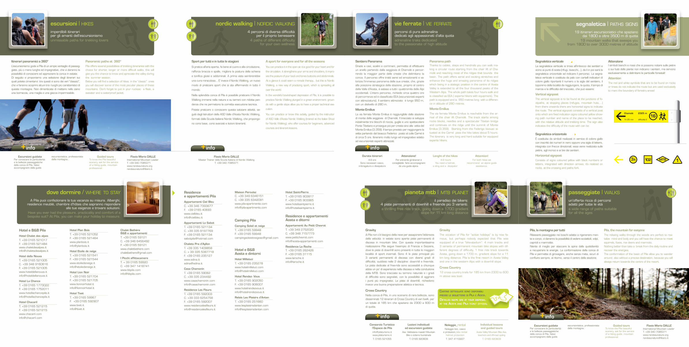
Arrivati in cima alla seggiovia Chamolé, a soli 10 minuti di cammino pressoché pianeggiante arriverete al laghetto alpino di Chamolé.When you arrive at the end of the chair lift called Cha-molé, in an amost fl at path you will reach the unique mountain lake Chamolé in about 10 minutes.
Il sentiero delle Marmotte è immerso in un ambiente na-turale di notevole bellezza, gode di viste panoramiche su importanti ghiacciai e sulle più alte vette europee. Lungo il percorso sono posizionati alcuni punti esplicativi, a tema, sulle varie particolarità naturalistiche che si possono os-servare. L’escursione, adatta a tutta la famiglia, è am-bientata in un panorama ricco di fl ora e fauna. Durata 2 ore (chiedete il depliant specifi co presso le biglietterie).The path called “ Marmotte” is situated in a natural envi-ronment of remarkable beauty, here you can enjoy ama-zing views over the most incredible glaciers and the hi-ghest peaks of Europe. Along the path some information panels are located. The panels give details about different topics concerning the particular features of the natural environment that surrounds you. The hike is suitable for the whole family in a landscape rich in fl ora and fauna. The hike takes 2 hours of walk (Ask for the specifi c leafl et at the ticket offi ce).
Dall’arrivo della seggiovia Chamolé potete decidere di ri-entrare a Pila, a piedi, seguendo la strada poderale sino alla partenza della telecabina (durata 1 ora e mezza).When you arrive at the end of the Chamolé’s chair lift you can decide to return to Pila by footh following the farm road until the cable car. ( The walk takes 1 hour and a half)
All’arrivo della Seggiovia di Chamolé si scende verso destra e attraverso un ampio sentiero che attraversa pascoli e boschi si raggiunge la partenza della seggiovia Couis 1(verifi care periodo apertura) all’arrivo della quale, proprio sulla cresta della conca di Pila si apre una balco-nata naturale sulla Valle di Cogne, la Valnontey, la Grivola e il Gran Paradiso. Il panorama è davvero mozzafi ato! (durata 45 minuti)Rientro a Pila a piedi seguendo il comodo sentiero sotto la seggiovia (durata 60 minuti). Se non appartenete alla categoria dei grandi camminatori, sedetevi in seggiovia e scendete nella stazione a valle della quale in 50 minuti si rientra a Pila.At the end of the chairlift called Chamolé walk down through a wide path on your right which cross the pastu-res and the woods and reach the chair lift called Couis 1 ( please check the opening period), take the lift and at the end you will fi nd yourself in an amazing natural balcony over the Valley of Cogne, the Valley of Valnontey, the Grivola and the gorgeous Gran Paradiso. The view is really breathtaking. ( The hike takes 45 minutes walk). You can return to Pila by footh just following the path that goes under the chair lift in 60 minutes or if you are not a great hiker sit again on the chair lift and return back down to the starting point of the lift. Then walk down for 50 minutes and reach Pila.
Se volete più semplicemente immergervi tra i boschi in una breve passeggiata scegliete l’initerario 5 che vi con-duce all’Eremo di San Grato in soli 25 minuti di strada pianeggiante.If you desire a simply and short walk through the enchan-ted woods choose the Path n.5 that takes you to the hermitage of San Grato in only 25 minutes walk on a fl at path.
Itine
rario_
rout
e N
° 1
Itine
rario_
rout
e N
° 2
Itine
rario_
rout
e N
° 3
Itine
rario_
rout
e N
° 4
Itine
rario_
rout
e N
° 5
Da 1800 a 2752 m di quota, a fil di cielo...senza faticaFrom 1800 to 2752 metres of altitude, in the edge of the sky ... without any effort il Tour dei 3 impianti | TOUR OF THE 3 SKI TOWS
un’opportunità per esplorare in giornata i luoghi più belli della conca di Pila abbinando impianti di risalita e un piacevolissimo trekking
seize the chance to explore in one day only the most amazing places of the basin of Pila using the ski tows and making a pleasant trekking

+info +info
Parco Avventura per tutti!Gli aspiranti Indiana Jones sono i benvenuti per cimentarsi nel nuovissimo Parco Avventura: massimo divertimento, immersi nella natura, per grandi e bambini; un’occasione per misurarsi con se stessi e provare i propri limiti eser-citando le capacità cognitive, creative e percettive. Ponti tibetani, passerelle su tronchi, teleferiche, ponti di rete che scatenano l’adrenalina, ma sempre in totale sicurezza con corde, moschettoni, imbracature e l’assistenza costante del personale dell’adventure park. Quando siete pronti a divertirvi veramente mettete in conto 45 minuti del vostro tempo: quindici per familiarizzare con l’attrezzatura e circa 30 per completare uno dei 4 percorsi adatti a tutti i livelli di agilità.
5 PERCORSI E 40 PIATTAFORME
Scoiattoli: semplice accessibile ai bambini (20 min. ca.)Marmotte: per bambini più grandi (percorrenza: 20 min. ca.)Camosci: impegnativo e adatto ai più esperti (20 min. ca.)Aquile e Super Aquile: con ardui passaggi esposti (30 min. ca. per ogni percorso)
Adventure Park for all!
All those budding Indiana Jones’s are welcome to try out the brand new Adventure Park. We have set up this initia-tive in order to offer some open air entertainment for our enthusiastic public. It will be great fun getting used to the ropes, harnesses and clips and everything else that you need for fl ying from one tree to another, always in complete safety. It is an opportunity to challenge yourself and test out your personal limits, exercising your creative and perceptive abilities.
5 TRAILS AND 40 PLATFORMS
Squirrels: simple and suitable also for young children (length: 20 min.)Marmots: for older children (length: 20 min.)Chamois: suitable for those with more experience (length: 20 min.)Eagles: suitable for those who want to experiment some adrenaline (length: 30 min.)Super Eagles: very diffi cult route (length: 30 min.)
I ristoranti in quota, aperti durante il periodo estivo, possono essere una gustosa alternativa al pic nic durante le escursioni.
The restaurants situated over 1800 metres of altitude are opened during the summer season and offers you delightful and
tasty meals giving you an alternative to your picnics during your walks.
parco avventura | ADVENTURE PARC
* la misura dell’altezza va presa da terra sino al polso con il braccio teso verso l’alto.* the height measurement is taken from the ground up to the wrist, with the arm held up high.
A Pila per soddisfare occhi e palato bisogna solo prendersi una pausa e rilassarsi, a tutto il resto pensiamo noi: prodotti
genuine, atmosfera e tanta passione!In Pila, in order to enjoy the taste experience, all you have
to do is to relax and leave the rest to us: genuine products, atmosphere and plenty of passion!
dove mangiare / WHERE TO EAT
DurataTempo di percorrenza di tutti
i percorsi 2 ore ca.
Altezza minima richiestabambini 140/160 cm*
ragazzi 140 cm*/15 anni adulti oltre 15 anni
PeriodTo access all the trails it will
take about 2 hours.
Minimum height requiredchildren 140/160 cm*
boys 140 cm*/15 yearsadults beyond 15 years
RistorantiBelvedere
T. +39 0165 521494F. +39 0165 [email protected]
La Piazzetta
T. +39 0165 521473 F. +39 0165 521019
Yeti
T. +39 0165 521181
Brasserie du Grimod
T. +39 0165 521431
Trattoria dei Maestri
T. +39 0165 252999
Chalet du Soleil
C. +39 328 1279040
Baita Chamolé
C. +39 348 2285440
Maison de Jean
T. +39 0165 521441C. +39 338 [email protected]
La Locanderia
C. +39 388 [email protected]
La Gabella
T. +39 0165 [email protected]
Bar e ristoranti in quotaGrand Grimod Leissé
C. +39 339 3446172C. +39 328 2919275
Lo Bautson
C. +39 348 [email protected]
La Baraka
C. +39 320 [email protected]
Hermitage
C. +39 335 8024695C. +39 340 [email protected]
La Chatelaine
C. +39 329 6693901 [email protected]
Société anonyme de Consommation
C. +39 339 5355644F. +39 0165 [email protected]
Rifugio Arbolle
T. +39 0165 50011C. +39 335 8056781C. +39 345 [email protected]
2 ore da trascorrere in una vera e propria palestra di sviluppo motorio, in tutta sicurezza.Enjoy 2 hours in a real motor development gymin complete safety.
Residencee appartamenti PilaAppartamenti Ciel Bleu
C. +39 346 7393677 F. +39 0165 40693www.cielbleu.it [email protected]
Appartamenti Lo Sabot
T. +39 0165 521134 C. +39 335 8197769F. +39 0165 [email protected]
Chalets Pra d’Ayllon
T. +39 335 1409858 C. + 39 335 5387718 F. +39 0165 235127www.edina.it [email protected]
Casa Chamonin
T. +39 0165 59062 C. +39 335 [email protected]
Residence Les Fleurs
T. +39 0165 592003 C. +39 333 6254758 F. +39 0165 592007www.residencelesfl eurs.it info@residencelesfl eurs.it
Maison PeroulazC. +39 349 6346151C. +39 335 6342091www.pila-apartments.com [email protected]
Camping PilaCamping Soleil et neige
T. +39 0165 59948 F. +39 0165 [email protected]
Hotel e B&B Aosta e dintorniHotel Milleluci
T. +39 0165 [email protected]
Hotel Rendez- Vous
T. +39 0165 902050F. +39 0165 [email protected]
Relais Les Plaisirs d’Antan
T. +39 0165 251660 www.lesplaisirsdantan.com [email protected]
Hotel Saint-Pierre
T. +39 0165 903817 F. +39 0165 903965www.hotelsaintpierre.it [email protected]
Residence e appartamenti Aosta e ditorniAppartamenti Au Petit Chevrot
T. +39 349 2752020 C. +39 348 7157773www.petitchevrot.com [email protected]
Residence La RocheT. +39 0165 262426 F. +39 0165 31115www.laroche.it [email protected]
A Pila puoi confezionare la tua vacanza su misura. Alberghi, residence meublé, chambre d’hôtes che sapranno rispondere
alle tue esigenze e trovare soluzioni.Have you ever had the pleasure, practicality and comfort of a bespoke suit? At Pila, you can make your holiday to measure.
passeggiate | WALKS
un’offerta ricca di percorsi adatti per tutte le età a wide range of paths suitable for all the ages
dove dormire / WHERE TO STAY
GravityA Pila non c’è bisogno della neve per assaporare l’ebbrezza della velocità: in estate sono aperte piste permanenti di discesa in mountain bike. Con questa importantissima realizzazione Pila segue l’esempio di Francia e Svizzera, dove le piste di downhill sono presenti in tutte le maggiori località di sport invernali. Sono 4 le piste principali più 3 varianti permanenti di discesa con diversi gradi di diffi coltà, suddivisi nelle 2 discipline: down-hill e free-ride. Le piste dedicate al free-ride sono accessibili a chiunque abbia un po’ di esperienza nella discesa e nella conduzione della MTB. Sono tracciate su terreno naturale e i gradi di diffi coltà sono segnalati, con la possibilità di aggirare i punti più impegnativi. Le piste di downhill, richiedono invece una buona preparazione atletica e tecnica.
Cross CountryNella conca di Pila, in uno scenario di rara bellezza, sonodisseminati 12 itinerari di Cross Country di vari livelli, per un totale di 185 km che spaziano da 2300 a 600 m di quota.
GravityThe vocation of Pila for “active holidays” is by now fa-mous, but perhaps nobody expected that Pila was equipped of a true “bike-stadium”: 4 main tracks and 3 variants of permanent mountain bike slopes with dif-ferent degrees of diffi culty, 1 free ride track towards Aosta, going down a 1700 m. gradient slope for a 11 km long distance. Pila is the fi rst resort in Aosta Valley and one in the western Alps with a downhill slope.
Cross Country12 cross country trails for 185 km from 2300 to 600 m above sea level.
CARTINE DETTAGLIATE SONO DISPONIBILI PRESSO LE BIGLIETTERIE DI PILA E AOSTA.DETAILED MAPS ARE AT YOUR DISPOSAL AT THE AOSTA AND PILA TICKET OFFICES.
+infoConsorzio Turistico
l’Espace de [email protected]
T. 0165 521055
Lezioni individuali ed escursioni guidate
Ass. Valdostana maestri Mountain Bike e ciclismo fuoristrada
T. 0165 920609
Noleggio_rentalNoleggio bici, casco
e protezioni_bike rental helmet protection
T. 347 4110227
Individual lessonsand guided tours
Aosta Valley Mountain Bike Ass. teachers and off-road cycling
T. 0165 920609
AT THE AOSTA AND PILA TICKET OFFICES.
il paradiso dei bikers: 4 piste permanenti di downhill e freeride più 3 varianti. a thrilling free ride track, going down a 1700 gradient
slope for 11 km long distance
pianeta mtb | MTB PLANET
Escursioni guidatePer conoscere le particolarità e le bellezze paesaggistiche della conca di Pila, fatevi accompagnare dalla guida
escursionistica, professionista della montagna.:
Guided toursTo know the Pila beautiful scenery, ask for the service of a hiking guide, mountain professional:
Flavio Mario DALLEInternational Mountain LeaderT. +39 340 [email protected]
Pila, la montagna per tuttiRilassanti passeggiate nei boschi adatte a rigenerare men-te e corpo, vi daranno la possibilità di vedere scoiattoli, volpi, caprioli e marmotte.Niente di meglio per staccare la spina dalla quotidianità e recuperare le energie. La conformazione della conca di Pila vi permette di girovagare, anche senza meta, sicuri di confl uire sempre, al ritorno, verso il centro della stazione.
Pila, the mountain for eveyone The relaxing walks through the woods are perfect to revi-talize mind and body and you will have the chance to meet squirrels, foxes, roe deers and marmots. Nothing better than take a break from the daily routine and recover the energies.The conformation of the basin of Pila allow you to wander around, also without a precise destination, because you will always return towards the centre of the resort.
+info
Hotel e B&B PilaHotel Chalet des alpes
T. +39 0165 521017F. +39 0165 521484www.chaletdesalpes.it [email protected]
Hotel della Nouva
T. +39 0165 521005 C. +39 348 9160616 F. +39 0165 [email protected]
Hotel La Chance
T. +39 0165 1773022 F. +39 0165 [email protected]
Hotel Chacaril
T. +39 0165 521215F. +39 0165 [email protected]
Hotel Plan Bois
T. +39 0165 521052 F. +39 0165 [email protected]
Hotel Etoile de neige
T. +39 0165 521541F. +39 0165 [email protected]
Hotel Lion Noir
T. +39 0165 521704F. +39 0165 [email protected]
Hotel Tivet
T. +39 0165 59967 F. +39 0165 592907www.tivet.it [email protected]
Chalet Bethère B&B e appartamenti
T. +39 0165 59121 C. +39 346 6456492 F. +39 0165 [email protected]
I Picchi affi ttacamere
T. + 39 0165 59920 C. +39 347 [email protected]
segnaletica | PATHS SIGNS
3A 102 MTB 1
Segnaletica verticaleLa segnaletica verticale si trova all’imbocco dei sentieri e vicino ai punti di sosta (rifugi, bivacchi,..), da lì in poi sarà la segnaletica orizzontale ad indicare il percorso. La segna-letica verticale è costituta da palo con cartelli indicatori di colore giallo riportanti il numero o la sigla del sentiero, il toponimo della località da raggiungere, la quota, il tempo di marcia e la diffi coltà del tracciato, che può essere:
Vertical signpostThe vertical signpost is to be found at the junctions of fo-otpaths, at stopping places (refuges, mountain huts,…) from there onwards there are horizontal signs to indicate the route. The vertical signpost consists of a vertical post onto which are fi xed indication signs coloured yellow show-ing path number and name of the place to be reached, with the relative altitude and trekking time. The sign also indicates the diffi culty of the route with can be:
Segnaletica orizzontaleÈ costituita da simboli realizzati in vernice di colore giallo con inscritti dei numeri in nero oppure una sigla di lettere, integrata con frecce direzionali; essa viene realizzata sulle pietre, agli incroci e ai bivi dei sentieri.
Horizontal signpostConsists of signs coloured yellow with black numbers or letters, integrated with direction arrows; it’s realized on rocks, at the crossing and paths fork.
AttenzioneI simboli bianchi e rossi che si possono notare sulle pietre o sui fusti delle piante non indicano i sentieri, ma servono esclusivamente a delimitare le particelle forestali!
AttentionThe red and white symbols that are to be found on rocks or trees do not indicate the route but are used exclusively to marc the boundary of forestry areas!
19 itinerari escursionistici che spaziano dai 1800 a oltre 3500 m di quota
19 mountain walks that sweeps you from 1800 to over 3000 metres of altitude
escursioni | HIKES
Itinerari panoramici a 360°L’escursionismo gode a Pila di un ampio ventaglio di passeg-giate, più o meno lunghe ed impegnative, che vi daranno la possibilità di conoscere ed apprezzare la conca in estate. Di seguito vi proponiamo una selezione degli itinerari sui quali potete cimentarvi: tra questi vi sono dei veri “classici”, che vi faranno scoprire alcuni tra i luoghi più caratteristici diqueste montagne. Non dimenticate di mettere nello zaino una borraccia, una maglia e una giacca impermeabile.
Panoramic paths at 360°Pila offers several possibilities of trekking itineraries with the choice for shorter, longer or more diffi cult walks, this will give you the chance to know and apreciate the valley during the summer season.Below you will fi nd a selection of hikes: in the “classic” ones you will discover some of the most peculiar places of these mountains. Don’t forget to put in your rucksac a fl ask, a sweater and a waterproof jacket.
imperdibili itinerari per gli amanti dell’escursionismounmissable paths for trekking lovers
percorsi di pura adrenalina dedicati agli appassionati d’alta quotaadrenaline traks dedicated to the passionate of high altitude
+info
Sentiero PanoramaGrazie a cavi, scalini e corrimani, permette di effettuare un anello partendo dalla seggiovia di Chamolé e percor-rendo la maggior parte delle creste che delimitano la conca. Il percorso offre tratti aerei ed emozionanti e va-lorizza l’immenso panorama delle sue creste, che, grazie alla posizione strategica della stazione, proprio al centro della Valle d’Aosta, è esteso a tutti i quattromila delle Alpi occidentali. L’intero percorso, richiede circa quattro ore di percorrenza ed è classifi cato EEA (escursionisti esperti con attrezzatura). Il sentiero attrezzato è lungo 950 m, con un dislivello di 280 m.
Monte EmiliusLa via ferrata Monte Emilius è raggiungibile dalla stazione di monte della seggiovia di Chamolé. Il tracciato si sviluppa inizialmente tra blocchi di roccia, guglie e uno spettacolare Ponte Tibetano e prosegue poi per cresta sino alla vetta del Monte Emilius (3.359). Il tempo previsto per raggiungere la vetta partendo dal bivacco Federico posto al colle Carrel è di circa 5 ore. Itinerario molto lungo ed impegnativo adatto ad escursionisti esperti attrezzati.
Panorama pathThanks to cables, steps and handrails you can walk ma-king a circular route starting from the chair lift of Cha-molé and reaching most of the ridges that bounds the basin. The path offers aerial and exciting stretches and enhance the huge and amazing panorama of its ridges which being in a stategic position in the centre of Aosta Valley is extended to all the four thousand peaks of the Western Alps. The whole path takes four hours walk and is classifi ed as EEA ( experts hikers with equipment). The path is equipped and is 950 metres long with a differen-ce in altitude of 280 metres.
Monte EmiliusThe via ferrata Monte Emilius is reachable from the ar-rival of the chair lift Chamolé. The track starts among rocks blocks, needles and a spectacular Tibetan bridge and continues on the ridge until the summit of Monte Emilius (3.359). Starting from the Federigo bivouac si-tuated at the Carrel pass the hike takes about 5 hours. The itinerary is very long and hard suitable for equipped experts hikers.
Durata itinerari4-9 ore
Sono necessari casco, imbragatura e dissipatore
Attenzione!Per entrambi gli itinerari è
consigliabile farsi accompagnare da una guida alpina.
Lenght of the hikes 4-9 hours
You need a helmet, a sling and a dissipator
Attention!For both hikes we
recommend an alpine guide assistance.
vie ferrate | VIE FERRATE
4 percorsi di diversa diffi coltà per il proprio benessere
4 paths of different diffi culty for your own wellness
+info+info
nordic walking | NORDIC WALKING
Escursioni guidatePer conoscere le particolarità e le bellezze paesaggistiche della conca di Pila, fatevi accompagnare dalla guida
escursionistica, professionista della montagna.:
Guided toursTo know the Pila beautiful scenery, ask for the service of a hiking guide, mountain professional:
Flavio Mario DALLEInternational Mountain LeaderT. +39 340 [email protected]
Sport per tutti e in tutte le stagioni
Si pratica all’aria aperta, fa bene al cuore e alla circolazione,
rafforza braccia e spalle, migliora la postura della schiena
e tonifi ca glutei e addominali. A prima vista sembrerebbe
una cura miracolosa... E’ invece il Nordic Walking, un nuovo
modo di praticare sport che si sta affermando in tutto il
mondo.
Nella splendida conca di Pila è possibile praticare il Nordic
Walking immersi nella natura e su terreni con ridotta pen-
denza che ne permetono la corretta esecuzione tecnica.
Potete praticare o conoscere questa salutare attività, se-
guiti dagli Istruttori della ASD Valle d’Aosta Nordic Walking,
formati dalla Scuola Italiana Nordic Walking, che propongo-
no corsi base, corsi avanzati e lezioni itineranti.
A sport for everyone and for all the seasons
You can practice it in the open air, it is good for your heart and for
the circulation, it strengthens your arms and shoulders, it impro-
ves the posture of your back and tones buttocks and abdominals.
At a glance it could seem a miracle therapy... but this is Nordic
Walking, a new way of practicing sport, which is spreading all
over the world.
In the wondeful bowl-shaped depression of Pila, it is possibile to
practice Nordic Walking plunged in a green environment: groun-
ds with a gentle slope allow you to have a proper technical exe-
cution.
You can practice or know this activity, guided by the instructor
of ASD Valle d’Aosta Nordic Walking (trained at the Italian Shool
for Nordic Walking), who offer courses for beginners, advanced
courses and itinerant lessons.
Flavio Mario DALLEMaster Trainer della Scuola Italiana di Nordic Walking
T. +39 340 7085371
Chamolé 2325 m
1h 25 min diffi coltà E16

vie ferrate_vie ferrate
Bar Ristorante Grand Grimod Leissé · m 2273
Alpe Liautaysaz
Bar Ristorante
Partenza Seggiovia Grimod
Alpe Grimondet
Alpe Grand Grimod
Partenza Seggiovia Couis II
Alpe Champchenille
Mon
te G
rivo
la · 3
96
9 m
Poi
nte
du
Dri
nc
. 2
66
2 m
Pun
te d
e L
a Pie
rre
· 2
65
3 m
Gra
nd
Nom
enon
. 3
48
8 m
Cou
is II ·
26
62
m
Pun
ta M
onpe
rs · 2
79
4 m
Pun
ta V
alle
ttaz
· 3
09
0 m
Pun
ta G
arin
· 3
45
7 m
Bec
ca d
i Non
a ·
31
42
m
Pun
ta d
i Lep
pe · 3
30
7 m
Cou
is I . 2
70
0 m
Mon
te E
mili
us · 3
55
7 m
Pia
tta
de G
révo
n · 2
75
2 m
Cre
sta
Ner
a ·
28
20
m
Bar Ristorante La Baraka · m 2310
Alpe Chamolé
Lago Chamolé
Rifugio Arbolle
Colle di Chamolé
Sentiero delle Marmotte
Lago Leissé
Plan de l’EyveSeggiovia Couis I
Arrivo seggiovia Grimod
Bar Ristorante Société Anonyme deConsommation · m 2250
Partenza seggiovia Grimondet
Consorzio Espace Pila
Centro Traumatologico
Parco giochi
Pattinaggio
Parco avventura
Pila Spa
Bar Ristorante La Châtelaine · m 2280
Bar Tavola Calda Hermitage · m 2000
Monumento alpini
Chiesa
Punto panoramico Couis I
Seggiovia Chamolé
Parco giochi
Telecabina
Stalla
Lago dellaNouva
dei Vitelli
Arrivo seggiovia Leissé
Les FleursPerrialMoline
Lo Baoutson · m 2200
Capanna Arno
Partenza seggiovia Leissé
CharemozTivet
Col Replan
AreaFree Style
Area sosta camper
Plan Fenêtre
Alpe Comboé
Eremo di St-Grat
CombatissièreCharvensod
BrenTurlinOzein
PILA
PILA GORRAZ
Col
Chas
èche
. 2
81
5 m
(Tsa
Sèt
se)
passeggiate ed escursioni_tracks nordic walking_nordic walking
legenda_legend
vie classiche_classic routes
Pila › Alpe Comboé 2h 10’Eremo di St. Grat [T] 0h 25’Alpe Chamolé [T] 1h 10’
Alpe Comboé [E] 0h 40’
Pila › Rifugio Arbolle 3h 10’Eremo di St. Grat [T] 0h 25’Alpe Chamolé [T] 1h 10’
Lago Chamolé [E] 0h 30’
Rifugio Arbolle [E] 1h 05’
Pila › Lago di Chamolé 1h 25’Alpe Chamolé [E] 0h 55’Lago Chamolé [E] v0h 30’
Pila › Eremo di San Grato 1h 00’tempo di percorrenza_walking time 0h 30’*dislivello_gradient 1806 ›1787 m
diffi coltà_diffi culty facile_easyterreno_hard ground duro_hard
Pila › Turlin 2h 40’tempo di percorrenza_walking time 1h 20’*dislivello_gradient 1806 ›1456 m
diffi coltà medio facilediffi culty middle easyterreno_hard ground duro_hard
Pila Gorraz › Lago di Chamolé 3h 40’tempo di percorrenza_walking time 1h 50’*dislivello_gradient 1877 › 2325 m
diffi coltà_diffi culty diffi cile_diffi cultterreno_hard ground duro_hard
Pila › Turlin 2h 40’tempo di percorrenza_walking time 1h 20’*dislivello_gradient 1877 ›2160 m
diffi coltà medio diffi cilediffi culty middle diffi cultterreno_hard ground duro_hard
Pila Gorraz › Alpe Chamolé 0h 50’Alpe Chamolé [E] 0h 50’
Pila Gorraz › Plan Fenêtre 2h 25’Arrivo Seggiovia Chamolé [T] 1h 35’Lago Chamolé [E] 0h 15’
Col Replan [E] 0h 15’
Plan Fenêtre [E] 0h 20’
Pila Gorraz › Col Chasèche 2h 50’Col Chasèche [E] 0h 55’
Pila Gorraz › Lago di Chamolé 1h 40’Partenza Seggiovia Couis 1 [E] 0h 50’
Lago Chamolé [E] 0h 50’
14I 14
14I
19C
19D
19D
19C
16
14
19
22
16
16
14
20A
19C
14
Pila Gorraz ›‹ Alpe Grand Grimod 1h 50’Lac de Leissé [E] 0h 45’Alpe Grand Grimod [T] 0h 20’
Partenza Seggiovia Grimod [T] 0h 15’
Pila Gorraz [T] 0h 30’
Pila Gorraz › Pointe du Drinc 2h 30’Partenza Seggiovia Couis 2 [T] 1h 45’Pointe du Drinc [E] 0h 45’
Pila Gorraz › Capanna di Arno 2h 25’Alpe Chamolé [E] 0h 45’Arrivo Seggiovia Leissé [E] 0h 40’Capanna Arno [E] 1h 00’P.to panoramico Couis 1 [E] 1h 00’
22A
22A
23A
22B
22A
23A
22B
22A
23A
22A
Pila › Les Fleurs 0h 45’Les Fleurs [E] 0h 45’
Pila › Tivet 1h 05’Charemoz [E] 0h 40’Tivet [E] 0h 25’
Pila › Becca di Nona [E] 4h 25’
Pila Gorraz › Mont Emilius [EE] 5h 20’
Pila Gorraz › Punta Vallettaz [EE] 3h 25’
21
23B
21
23B
23B
23B
16
14
19A
Pila › Monumento Alpini 0h 25’Monumento Alpini [T] 0h 25’
Pila › Turlin 1h 20’Alpe Bren [E] 0h 45’Turlin [E] 0h 35’
Pila › Eremo St-Grat › Alpe Combatissière 0h 35’Eremo St-Grat [T] 0h 25’Alpe Combattissière [E] 0h 10’
Pila Gorraz › P.te de la Pierre › Col Chasèche 4h 50’Alpe Liautaysaz [T] 1h 00’Alpe Champchenille [E] 0h 45’Pointe de la Pierre [E] 1h 15’Col Chasèche [EE] 1h 15’
24
21
14I
21
14I
20
22
16
22
16
* sola andata_one way
PARCHEGGIO piazzale arrivo telecabina
PARCHEGGIO piazzale funivia
Difficoltà del tracciato
[T] Itinerario escursionistico turistico Tourist trekking route
[E] Itinerario escursionistico privo di diffi coltà tecniche Trekking excursion route without technical diffi culty
[EE] Itinerario per escursionisti esperti Trekking excursion route for expert
[EEA] Itinerario per escursionisti esperti con attrezzatura Trekking excursion route for expert with equipment
Pila Gorraz › Via Ferrata del Mont Emilius* 3h 30’Alpe Comboé [EE] 1h 20’Via Ferrata Mont Emilius [EE A] 2h 10’
Pila Gorraz › Sentiero attrezzato Panorama* 2h 55’Col Chasèche [EE] 2h 50’Sentiero attrezzato “Panorama” [EE A] 0h 05’
* i tempi indicati includono solo l’avvicinamento e non la ferrata
* indicated times only include the approach and not the via ferrata

I cani non pagano il biglietto sulla telecabina e sulle seggiovie che sono attrezzate di gabbie apposite per il loro trasporto.
Per il pranzo ti suggeriamo una sosta presso i ristoranti dislocati in quota che propongono piatti tipici innaffi ati da ottimi vini locali.
Se hai voglia di una tintarella i locali con solarium im-mersi nel verde sono pronti ad accogliervi!
Famiglia con bambini? In mattinata escursione al Sentie-ro delle Marmotte, a pranzo un pic nic lungo la riva del lago Chamolé e poi al pomeriggio tutti al PARCO AVVENTURA e per i più piccini area giochi.
Per una giornata in montagna con bimbi piccoli la rete di strade poderali offre percorsi facilmente percorribili anche con il passeggino.
Non abbandonate i rifiuti, siate discreti e rispettosi dell’ambiente.
Per gli amanti della pesca il Lago Chamolé è meta anche di appassionati di pesca alla trota. Per pescare è necessario essere muniti del permesso governativo rilascia-to nel proprio luogo di residenza e acquistare poi presso il Bar Mion (C. +39 339 6656195) il permesso giornaliero, settimanale o mensile.
Dogs don’t pay the ticket ont the cable car and on the chair lifts. The chairlifts are equipped with special cages for the transport.
We suggest you to stop for lunch in the restaurants si-tuated over 1800 metres of altitude. Typical and traditional dishes with excellent local wines are served.
If you want a suntan restaurants, bars and hotels with solarium situated in the middle of nature are ready to wel-come you!
Are you a family with kids? In the morning you can reach the Paths of the marmots, have a picnic lunch on the lake Chamolé and in the afternoon you can all go to the ADVENTURE PARK and for the little ones there is a playground.
For a whole day in the mountains with small kids there are easy farm roads that can be practicable also with pushchairs.
Don’t leave your garbage in the nature, respect the environment.
For the fishing lovers Lake Chamolé is the destination for many trout passionates fi shers. If you want to fi sh you need a government licence issued in your city of residence and than you have to buy the daily, weekly, monthly permit at the Bar Mion (C. +39 339 6656195).
per affrontare la montagna è importante indossare scarpe adatte e tenere conto delle previsioni meteo
if you want to hike in the mountains is important to wear suitable shoes and always look at the weather conditions
consigli utili | USEFUL ADVICESQui potete trovare tutti i contatti che possono fare al caso vostro.Here’s a list of all contacts you need.
numeri utili / USEFUL NUMBERS
AlimentariFOOD MARKETEnogastronomia Dahu
T. +39 0165 521718
I sapori della Valle
T. +39 0165 521066
BarBARBar Mion
C. +39 339 6656195
Bar della Nouva
T. +39 0165 521005
Bar Petit CafeC. +39 342 8538798
NegoziSHOPSBazar PilaGIORNALI, SOUVENIRS, GIOCHI
T. +39 0165 521163
ElettroserviziFERRAMENTA, CASALINGHI
T. +39 0165 521210
La Maison du SportARTICOLI SPORTIVI
T. +39 0165 [email protected]
ServiziSERVICESDitta FiabaneRISTRUTTURAZIONI
C. +39 335 8198784
Pila SkiC. +39 328 [email protected]
PelatransferNOLEGGIO CON CONDUCENTE
C. +39 329 [email protected]
Pila GasAREA DI SERVIZIO
T. +39 0165 521021
BCC ValdostanaSPORTELLO DI PILA
T. +39 0165 521456
FarmaciaT. +39 0165 521127
Comune di Gressan
T. +39 0165 [email protected]
Polizia Municipale
C. +39 329 3814237
Flavio DalleGUIDA ESCURSIONISTICA
C. +39 340 7085371
DISCO/PUBLa Niche discoteca
C. +39 348 3838051C. +39 348 [email protected]
Gallagher’s pub
T. +39 0165 1773022

ESPACE DE PILATEL 0165_521055
comunicazione
ME
TRÒ
STU
DIO
AS
SO
CIA
TO | fotografia
PIE
TRO
CE
LES
IA | stampa
TIP
OG
RA
FIA
VA
LDO
STA
NA
![[D&D 1e - ITA] - [Avventura] - La Maledizione Del Dio Rosso](https://static.fdocuments.us/doc/165x107/55cf8f0e550346703b987a89/dd-1e-ita-avventura-la-maledizione-del-dio-rosso.jpg)


![[D&D 2e - ITA] [Avventura] - I Fumi Del Genio](https://static.fdocuments.us/doc/165x107/55cf8f07550346703b983419/dd-2e-ita-avventura-i-fumi-del-genio.jpg)