Liberty Development: 2015 Summer Shallow Hazards … · Liberty Development: 2015 Summer Shallow...
24
Transcript of Liberty Development: 2015 Summer Shallow Hazards … · Liberty Development: 2015 Summer Shallow...


Liberty Development: 2015 Summer Shallow Hazards andStrudel Scour Bathymetry Work Plan
IntroductionHilcorp Alaska (Hilcorp) plans to conduct a shallow geohazard survey and strudel scour survey infederal and state waters of Foggy Island Bay in the Beaufort Sea during the spring break up andopen water season of 2015. The 2015 study area lies partially within the Liberty Unit (Liberty),(Figure 1). This document provides operational details of the strudel scour and shallowgeohazard survey.
PurposeHilcorp is evaluating the proposed route for a pipeline from the Liberty field. The Libertyreservoir is located in federal waters in Foggy Island Bay approximately 8 miles (mi) east of theEndicott Satellite Drilling Island (SDI). The pipeline route to be investigated will extend southfrom the proposed Liberty Island to tie into the Badami pipeline NW of the West KAD Valve. Anaerial reconnaissance of river overflow and strudel drainage features will be conducted duringspring break up. The purpose of the strudel scour survey is to map strudel drains on the icesurface in the vicinity of the proposed pipeline route. Strudel scouring can occur when theoverflood water drains through a hole or discontinuity in the sea ice, creating a vortex that canerode the seabed.
A sonar survey, using single-beam and multibeam echosounder, side scan sonar, sub-bottomprofilers, and magnetometer is planned over the subsea pipeline corridor area. The purposeof this proposed survey is to evaluate the existence and location of archaeological resources,potential geologic hazards and to investigate strudel scours on the seafloor and in theshallow subsurface.
Strudel Scour SurveyA field survey program will be conducted to obtain site specific information on river overfloodand strudel scours. The objective is to map and characterize newly formed and relic strudelscours within a 10,000 ft. corridor centered on the proposed pipeline alignment. The surveyprogram will consist of the following components:
• Spring aerial reconnaissance of river overflood and strudel drainage features
• Bathymetric survey at strudel drain locations (to be combined with SummerShallow Hazards Sonar Survey)
• Bathymetric survey along the proposed pipeline route to locate relic scours (to becombined with Summer Shallow Hazards Sonar Survey)
Spring 2015 Aerial Reconnaissance
Coastal Frontiers Corporation has performed more than forty helicopter-based river overfloodand strudel drainage feature mapping projects in the Alaskan Beaufort Sea during the past twodecades, including nine on behalf of the Liberty Development. The methods developed and
refined during these surveys will be used for the 2015 mapping effort.
The work will be conducted from a helicopter based in Deadhorse. Due to fuel limitations,several flights may be required to map all of the features. Operations are anticipated to occurbetween 0600 and 1800, with the exact timing of the flights dependent on aircraft availabilityand weather conditions. The helicopter will depart the base of operation with a scientific teamof two persons in addition to the aircraft crew, and transit over land to the vicinity of theEndicott Main Production Island (MPI) guided by Global Positioning System (GPS) navigation.The exact route and altitude will be selected by the aircraft crew based on safety,meteorological conditions, wildlife avoidance, and any flying restrictions at the time ofoperations.
Mapping will be performed using a survey-grade GPS unit operated from the helicopter. Toimprove the accuracy of the GPS position data, differential corrections broadcast in real time viasatellite by the U.S. Government’s Wide Area Augmentation System (WAAS) will be received bythe GPS unit. To assist with navigation, the GPS will be interfaced to a laptop computer usingthe Hypack Max survey software package.
The overflood limit on the sea ice will be delineated by recording successive positions whileflying over the observed boundary at an approximate altitude of 200 ft. and speed of 60 knots.The overflood boundary will be mapped from the Endicott causeway to Tigvariak Island, toallow direct comparison with historical overflood events in the project area.
A search for strudel drainage features located within a 10,000 ft. wide monitoring corridorcentered on the proposed pipeline route (Figure 2) will be performed by flying a reconnaissancepattern at an altitude of 200 to 500 ft. at speeds of 30 to 50 knots. Individual strudel holes inthe ice sheet will be mapped by hovering over each feature at an altitude of about 50 ft. forapproximately 15 seconds while recording GPS position fixes.
Schedule
The mapping program will be conducted at the time of spring break-up, which typically occursin late May or early June. To ensure that the maximum extent of the flood is documented, themapping will be conducted at or near the end of the overflood period rather than at its peak.
The aerial portion of the strudel scour surveys are expected to be conducted between May 15and June 15 and will be complete by mid-June.

Figure 1. Overview of the eastern Beaufort Sea with the outline of the Liberty Unit.

Figure 2. Strudel Scour Survey Operations Location Map

Open Water Shallow Hazard SurveyThe pipeline route geohazard survey will consist of the shallow geohazard and bathymetric strudelscour / ice gouge surveys. Data will be acquired along the subsea pipeline corridor area (Figure 3)using the single-beam or multibeam echosounder, side scan sonar, sub-bottom profilers, and themagnetometer as described below. The Liberty shallow geohazard survey will comply with NTL No.05-A02 pursuant to regulations at 30 CFR 250.201, 30 CFR 250.1007(a), and 30 CFR 250.1010.
Vessel Mobilization
One main vessel will be used for the geohazard survey. The proposed survey vessel (M/V Sidewinderor equivalent) is about 40 x 14 feet in size. This vessel is currently stationed on the North Slope andwill prepared and launched at West Dock or Endicott. Vessel preparation includes the assembly andinstallation of navigation, acoustic, and safety equipment. Once assembled, the navigation andacoustic systems will be tested and calibrated at West Dock or at the project site.
Because of the extremely shallow project area, additional small vessel may be utilized to safely extendsurvey operations. This will most likely be a small skiff or inflatable craft with limited crew and range.Small craft operations will be supported by the larger vessel.
Navigation and Data Management
The vessel will be equipped with a Global Positioning System receiving differential corrections from avariety of possible sources, including a shore-based kinematic base station.
Tidal corrections will be determined through GPS computation, comparison with any local tidegauges, or, if available, with tide gauges operated by other projects.
A navigation software package will display known obstructions, islands, and identified areas ofsensitivity. The software will also show the pre-determined line plans. The information will beupdated as necessary to ensure required data coverage. The navigation software will also recordall measured equipment offsets and corrections and vessel and equipment position at afrequency of no less than once per second during acoustic equipment operation.
Housing and Logistics
Approximately 10 people will be involved in the operation. Most of the crew will be accommodated atexisting camps and some crew will be housed on the vessel. Support activities, such as crew transfersand vessel re-supply are primarily planned to occur at Endicott and West Dock. However, supportactivities may also occur at other nearby vessel-accessible locations if needed (e.g. East Dock).Equipment staging and onshore support will primarily occur at West Dock, but may also take place atother existing road-accessible pads within the Prudhoe Bay Unit area as necessary. For protectionfrom weather, the vessel may anchor near West Dock, near the barrier islands, or other near shorelocations.

Figure 3. Project Area and Proposed Pipeline Route
Data Acquisition
Equipment that will be used for the proposed shallow geohazard survey includes single-beam ormultibeam echosounder, side scan sonar, sub-bottom profilers, and magnetometer. Details relatedto data acquisition are summarized below. Any substitution of the equipment will be inaccordance with permit requirements.
Equipment that will be used for the strudel scour and ice gouge survey will include multi-beam sonar(to obtain detailed bathymetric data in deep water), single-beam sonar (to obtain bathymetric data inshallow water and serve as a back-up to the multi-beam system in deep water), and side scan sonar(to locate ice gouges, strudel scours, and hard-bottom targets).
Survey Design
One vessel will be used for the proposed survey. The proposed vessel (M/V Sidewinder or equivalent)is about 40 x 14 feet in size. The sub-bottom profilers and magnetometer will be deployed from thevessel. The echosounder and side scan sonar will be hull-mounted. No equipment will be placed onthe sea floor as part of survey activities.
Data will be acquired along the subsea pipeline corridor area (Figure 3) using the single-beam ormultibeam echosounder, side scan sonar, sub-bottom profilers, and the magnetometer. Because ofthe shallow nature of the project area and small size of the vessel, systems will be towed in optimalgroupings that best facilitate safe operations and data quality. As necessary, a small vessel may beused to extend data collection into shallow waters. Survey planned lines will be designed to acquire150% side scan sonar data coverage, with line spacing dependent upon water depth. A 300 mcorridor around the proposed pipeline area will be covered.
The single-beam or multibeam echosounder and side scan sonar will be used to obtain high accuracyinformation regarding bathymetry of the seafloor. For accurate object detection, a side scan sonarsurvey is required to complement a multibeam echosounder survey.
The sub-bottom profiler will be used to generate high resolution images of the sub-bottomstratigraphy.
A marine magnetometer will be used for the detection of magnetic deflection generated bygeologic features and buried or exposed ferrous objects which may be related to archaeologicalartifacts or modern man-made debris. The magnetometer will be towed at a sufficient distancebehind the vessel to avoid data pollution by the vessel's magnetic properties. Magnetometerspassively measure changes in magnetic fields over the seabed and do not impact marine mammals.
The sound characteristics of the proposed shallow geohazard survey equipment are listed in Table 1below.
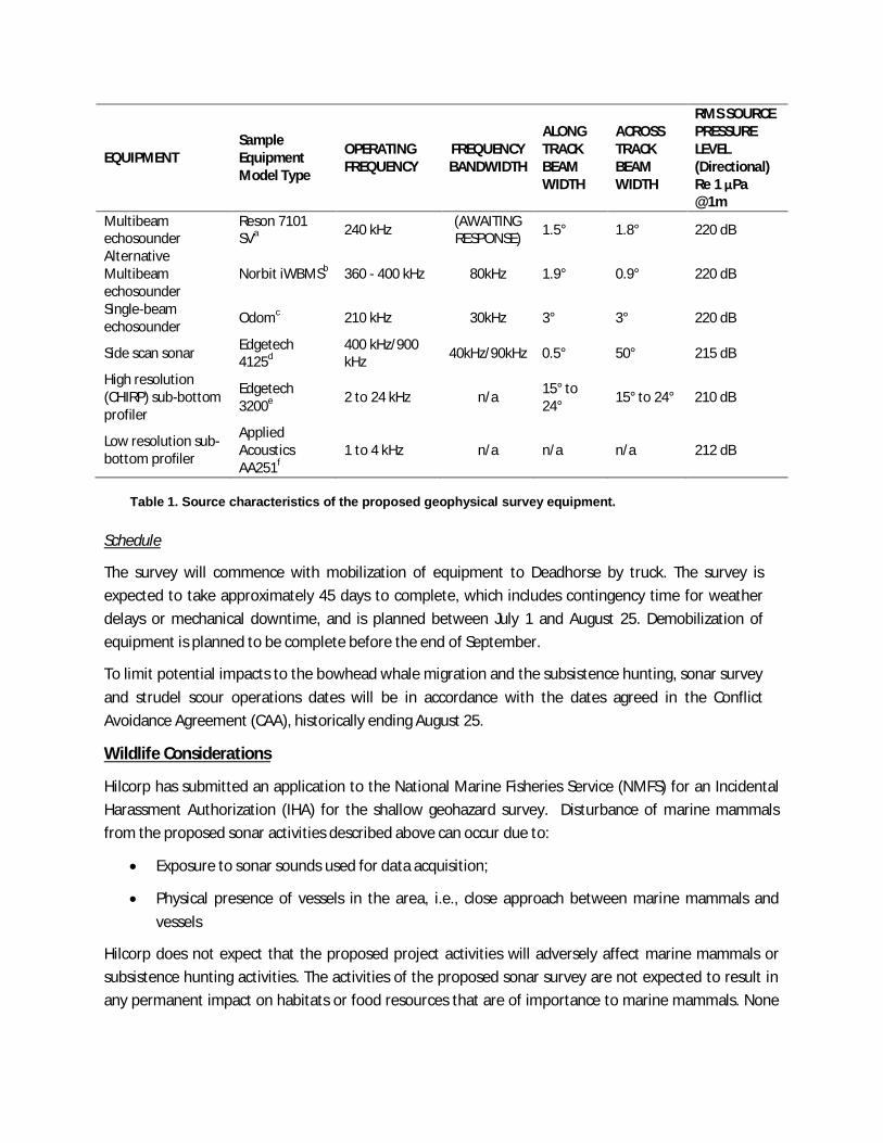
EQUIPMENTSampleEquipmentModel Type
OPERATINGFREQUENCY
FREQUENCYBANDWIDTH
ALONGTRACKBEAMWIDTH
ACROSSTRACKBEAMWIDTH
RMS SOURCEPRESSURELEVEL(Directional)Re 1 μPa@1m
Multibeamechosounder
Reson 7101SVa 240 kHz (AWAITING
RESPONSE) 1.5° 1.8° 220 dB
AlternativeMultibeamechosounder
Norbit iWBMSb 360 - 400 kHz 80kHz 1.9° 0.9° 220 dB
Single-beamechosounder Odomc 210 kHz 30kHz 3° 3° 220 dB
Side scan sonar Edgetech4125d
400 kHz/900kHz 40kHz/90kHz 0.5° 50° 215 dB
High resolution(CHIRP) sub-bottomprofiler
Edgetech3200e 2 to 24 kHz n/a 15° to
24° 15° to 24° 210 dB
Low resolution sub-bottom profiler
AppliedAcousticsAA251f
1 to 4 kHz n/a n/a n/a 212 dB
Table 1. Source characteristics of the proposed geophysical survey equipment.
Schedule
The survey will commence with mobilization of equipment to Deadhorse by truck. The survey isexpected to take approximately 45 days to complete, which includes contingency time for weatherdelays or mechanical downtime, and is planned between July 1 and August 25. Demobilization ofequipment is planned to be complete before the end of September.
To limit potential impacts to the bowhead whale migration and the subsistence hunting, sonar surveyand strudel scour operations dates will be in accordance with the dates agreed in the ConflictAvoidance Agreement (CAA), historically ending August 25.
Wildlife Considerations
Hilcorp has submitted an application to the National Marine Fisheries Service (NMFS) for an IncidentalHarassment Authorization (IHA) for the shallow geohazard survey. Disturbance of marine mammalsfrom the proposed sonar activities described above can occur due to:
· Exposure to sonar sounds used for data acquisition;
· Physical presence of vessels in the area, i.e., close approach between marine mammals andvessels
Hilcorp does not expect that the proposed project activities will adversely affect marine mammals orsubsistence hunting activities. The activities of the proposed sonar survey are not expected to result inany permanent impact on habitats or food resources that are of importance to marine mammals. None

of the project activities have the ability to damage or otherwise destruct marine mammal habitat thatwould result in habitat loss or modification.
As part of Hilcorp’s IHA application, a combination of active monitoring and mitigation measures will beimplemented to minimize project impacts to marine resources. If marine mammals are observed withinor about to enter specific safety radii around the proposed survey activities, mitigation will be initiatedby vessel-based protected species observers (PSOs). Additionally, avoidance guidelines and mitigationmeasures are developed in a formal agreement with the AEWC, individual community Whaling Captain’sAssociations, Hilcorp, and other Industry Participants in the form of the Conflict Avoidance Agreement(CAA).
Passive acoustic monitoring will be conducted to document ambient noise conditions, to examine thespatial and temporal distribution of marine mammals based on acoustic detections of theirvocalizations, and to characterize the long-range propagation of sounds produced during the geohazardsurvey.
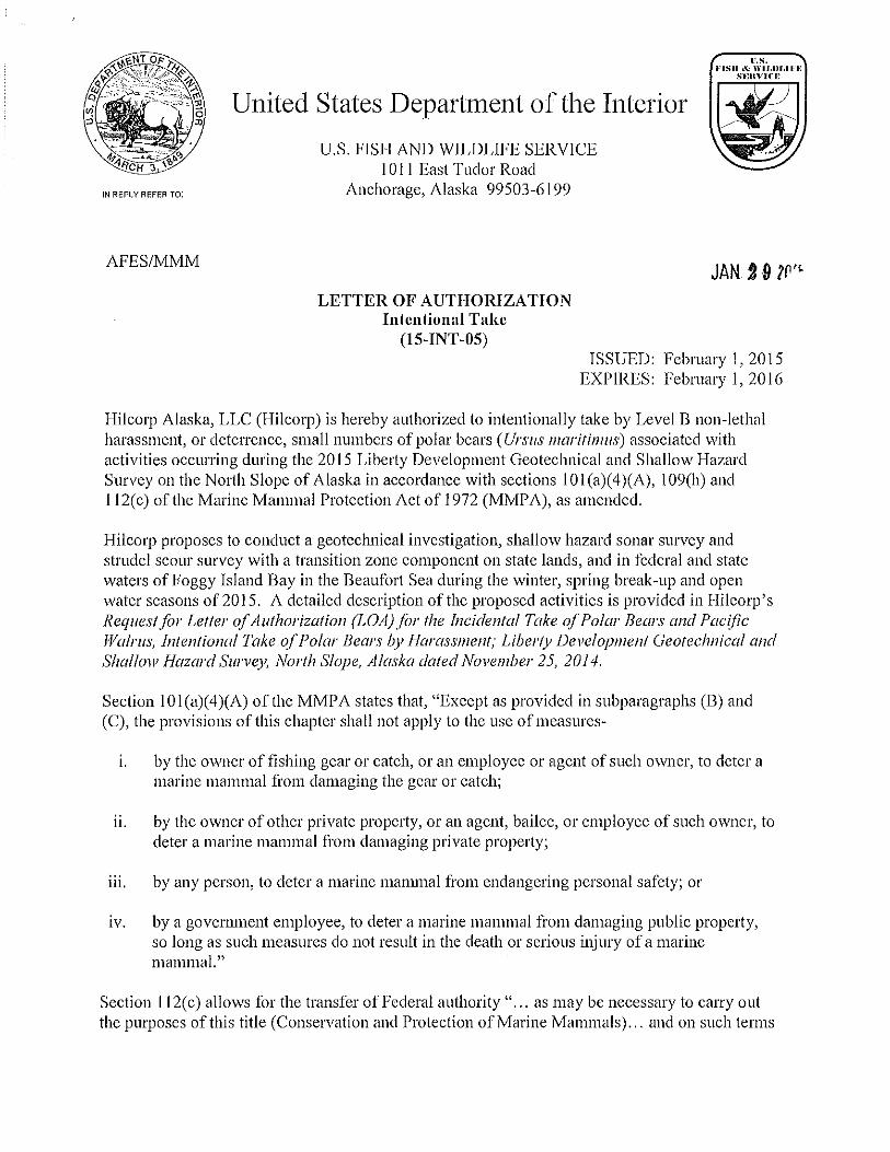
The project will be covered under a Letter of Authorization (LOA) from the U.S. Fish and Wildlife Service(USFWS) for conducting activities in polar bear habitat and appropriate migration efforts will be taken toavoid impacts to polar bears and Pacific walrus.


Hilcorp Alaska, LLC
ATTACHMENT V
Polar Bear and Walrus Interaction and Mitigation Plan
Purpose
The purpose of this Polar Bear and Walrus Interaction Plan is to standardize protocols andreporting efforts within Hilcorp Alaska, LLC (Hilcorp) operations fields on the North Slope, so thatwhen a walrus or polar bear encounters industry or industry-related activity, it is detected quicklyand responded to appropriately through avoidance, monitoring, reporting, or active deterrence byappropriate trained personnel under the guidance of the USFWS.
Those working in walrus or polar bear habitat must be familiar with all of the issues associatedwith polar bears and working safely in bear country. To insure this familiarity, each employeeworking at any Hilcorp facility, either employee or contractor will receive polar bear and walrusawareness training as described in the training section of this Plan. The Plan is designed toensure the safety of people, walrus and bears and work areas on the North Slope. Although it ispossible to generalize about good work practices in walrus and bear habitat, each area and worksite has its own unique layout, and as such, not all of the procedures discussed here may berelevant.
Hilcorp has adopted this Polar Bear and Walrus Interaction Plan in order to apply for Letters ofAuthorization (LOA) for the incidental take of polar bears and Pacific walrus for the Liberty Unitgeotechnical investigation, shallow hazard sonar survey and strudel scour survey on the NorthSlope of Alaska. In accordance with ESA Section 7, issuance of the LOA and compliance withthis document fulfill the requirement for Tier 2 Consultation of the existing ProgrammaticBiological Opinion for activities in Hilcorp operated fields. In addition, Hilcorp is also requestingauthorization for the intentional take of polar bears by harassment (deterrent activities) pursuantto section 101 (a)(4)(A), 109(h), and 112(c) of the Marine Mammal Protection Act (MMPA) for theprotection of both human life and polar bears while conducting activities for the Liberty Unitgeotechnical investigation, shallow hazard sonar survey and strudel scour survey on the NorthSlope of Alaska.
The occurrence of walrus in Hilcorp operating areas is rare; therefore this plan focuses mainly onPolar Bear interaction guidance.
Pacific Walrus Interaction and Reporting
Pacific Walrus Background
Walrus distribution varies seasonally; most of the population inhabits the Bering Sea duringwinter and the Chukchi Sea during summer. During the summer, males congregate at haul-outsin the Bristol Bay region, while females with young and subadults migrate through the BeringStrait to the pack ice edge in the Chukchi Sea. Small herds of walruses occasionally range eastof Point Barrow into the Beaufort Sea in late summer. Walruses utilize pack ice, ice floes, andcoastal haul outs for resting and calving. Walruses generally occur in shallow waters of 300 feetor less, though they are capable of diving deeper. Primarily juvenile walruses have been sightedin fields to be operated by Hilcorp, most recently near the Endicott Causeway in July 2013.
The Pacific walrus is a large pinniped (the group that contains seals, sea lions, and fur seals) andtheir skin color ranges from brown to pinkish red. Adult walruses, both males and females, haveivory tusks. Adult males can reach up to 12 feet long and can weigh up to two tons; females aresmaller and can weigh one ton. Juvenile walruses may be confused with seals or sea lions, theyare smaller, brown, and they may or may not have small tusks. Walruses generally flee when

Hilcorp Alaska, LLC
they are approached or are startled; females with calves and groups of walruses are mostsensitive to disturbance, solitary individuals and especially males are least sensitive. Researchconducted in 2006 estimated the Pacific walrus population to be between 55,000 and 507,000individuals. There is not enough available population data to estimate a population trend at thistime.
The Pacific walrus is protected under the Marine Mammal Protection Act of 1972, but is notcurrently listed as threatened or endangered. In 2008, the USFWS found that the listing of thePacific walrus as threatened was warranted, and is currently considered a Candidate species forlisting. The MMPA protects walruses from commercial harvest and limits harvest to AlaskaNatives for subsistence purposes.
Walrus Interaction Plan
If a walrus is sighted (alive or dead), do not approach the animal. Walruses cannot be hazed.Notify Security and the Hilcorp Wildlife Advisor immediately. Security or the wildlife Advisor willnotify USFWS and fill out a Pacific Walrus Sighting Report for the encounter. Hilcorp is requiredto report all walrus sightings and interactions to the USFWS within 24 hours. Walrus identificationand reporting requirements will be discussed during training for personnel working at Hilcorp’sfacilities (see the Training section of this plan).
Note that walrus females will leave their pups alone for periods of time; the pups can be highlyvocal during these times, but that does not necessarily mean that they are in distress or injured.
Operational Support Vessels
The captain or a designated crew member of vessels used as part of regular oilfield operationsshall maintain a watch for marine mammals during vessel operations and will alert the vesselcrew of the presence of walruses or other marine mammals. Vessels will maintain the maximumdistance possible from concentrations of walruses. Other than an emergency, vessels will notapproach within an 805-m (0.5-mi) radius of walruses observed on land or ice. Vessel operatorswill take every precaution to avoid harassment of concentrations of feeding walruses when avessel is operating near these animals. Vessels should reduce speed and maintain a minimum805-m (0.5- mi) operational exclusion zone around feeding walrus groups. Vessels may not beoperated in such a way as to separate members of a group of walruses from other members ofthe group. Vessels adjust speed according to weather conditions to avoid the likelihood ofcontact with marine mammals. Situations as described above are unlikely to occur in Hilcorpoperated fields, but are noted in the outside chance of such an occurrence.
Operating Conditions for Aircraft
Operators of support aircraft shall, at all times, conduct their activities at the maximum distancepossible from concentrations of walruses. Other than in an emergency, aircraft shall not beoperated at an altitude lower than 457 m (1,500 ft) within 805 m (0.5 mi) of walruses observed onice, observed in the water or land. Helicopters may not hover or circle above such areas or within805 m (0.5 mile) of such areas. When weather conditions do not allow a 457-m (1,500-ft) flyingaltitude, such as during storms or when cloud cover is low, aircraft may be operated below the457-m (1,500-ft) altitude stipulated above. However, when aircraft are operated at altitudes below457 m (1,500 ft) because of weather conditions, the operator must avoid areas of known walrusconcentrations and should take precautions to avoid flying directly over or within 805 m (0.5 mile)of these areas. Conditions such as these are unlikely to occur in Hilcorp operated fields, but arenoted in the outside chance of such an occurrence.

Hilcorp Alaska, LLC
Monitoring and Record Keeping
Record keeping is required to assist in oil field safety and to supplement USFWS data collection.The walrus sighting reports serve the purpose of monitoring the short-term direct effects oil fieldactivities may have on individual walrus, by assessing localized changes in movements,behavior, and habitat use of walrus in response to industry activities.
Whenever a walrus is sighted, a record must be made of the observations and any action takenby filling in a walrus interaction form. All blanks on the form must be completed before sendingthe form to the USFWS. This is critical for a complete record and must be done. All records willbe compiled by Security and forwarded to the USFWS and the Hilcorp Wildlife Advisor. The mostreadily accepted method to submit the form is through e-mail, however fax is also acceptable.Contact numbers and fax numbers are attached in Appendix 4. Hilcorp will maintain records of allwalrus sightings, and will compile annual summary reports required by the USFWS. The walrusSighting Form is attached to this document.
Polar Bear Interaction and Mitigation Plan
Polar Bear Background
Polar bears can be found anywhere on the North Slope; however, they are concentrated near thecoast and are most frequently sighted near facilities, roads and pads along the shoreline(particularly at Endicott, Northstar and Milne Point). Both single animals and females with cubsmay be sighted. Although polar bears are encountered throughout the year, they are most oftenseen during summer, fall and winter.
Polar bears can weigh over 1,500 pounds and measure 5 feet tall at the shoulder, or 12 feetwhen standing on their hind legs. They are excellent swimmers and can run 25 miles per hour.Because of their size, speed, and curious nature, any encounter with these large carnivores ispotentially dangerous. Recent studies show there are approximately 1,500 polar bears in theAlaskan Southern Beaufort Sea Population.
Polar bears are protected under the Marine Mammal Protection Act (MMPA) of 1972 and arelisted as threatened under the Endangered Species Act (ESA) of 1973 as amended in 2008. Inaccordance with the MMPA and ESA, it is illegal to “take” polar bears, meaning to “hunt, harassor kill, or to attempt to hunt, harass, or kill” a polar bear. On the North Slope, the USFWS is theregulatory authority tasked with oversight, management and conservation of polar bears. Otheragencies including the United States Geological Service Biological Resource Division (USGS-BRD) have staff involved with polar bear management and research.
The MMPA further defines harassment as “any act of pursuit, torment, or annoyance which (i)has the potential to injure a marine mammal or marine mammal stock in the wild [Level Aharassment]; or (ii) has the potential to disturb a marine mammal or marine mammal stock in thewild by causing a disruption of behavioral patterns, including, but not limited to, migration,breathing, nursing, breeding, feeding, or sheltering but which does not have the potential to injurea marine mammal or marine mammal stock in the wild [Level B harassment].”
Section 101(c) of the MMPA allows, without specific authorization, the take (including lethal take)of a polar bear if such a taking is imminently necessary in self-defense or to save the life of aperson in immediate danger, and such taking is reported to USFWS within 24 hours.
Hilcorp Alaska, LLC
Hilcorp’s Polar Bear Policy
Bear Safety Personnel
Hilcorp will continue working with Purcell Security at Milne Point and Endicott and ACS atNorthstar to manage bear interactions. Hilcorp will rely upon and follow the guidelines andprocedures Purcell has in place for hazing polar bears. Several of these guidelines are attach tothis Plan (Appendix 5). Purcell and ACS employees have provided bear hazing and reportingservices to BPXA for years at these facilities. Hilcorp has retained Purcell and ACS to provide thesame services and will require these contractors to continue to work with the USFWS to maintaintheir credentials to provide polar bear hazing training, monitoring and reporting.
Safety of Operations
Hilcorp’s Polar Bear Interaction Plan is designed to minimize human/polar bear interactions, toensure the safety of all personnel and mitigate any potential impacts to polar bear well-being andsurvival. The following list is a quick reference to general interaction plan policies as outlined inthis interaction plan. Those working in polar bear habitat must be familiar with issues associatedwith polar bears and working safely in bear country. Employees will be trained according to theirfield responsibilities as discussed in the Training Section of this Plan. Personnel working in polarbear habitat must abide by the following:
· Be aware of polar bear activity in your work area. When Security becomes aware ofa polar bear (either by direct observation or reporting), they will notify group supervisorsof the presence of the bear in the area. Radio transmission may also be used to notifyworkers in the vicinity. If you are starting work outside in an area with the potential forpolar bears, make sure you discuss how the presence of polar bears will becommunicated to you and your crew.
· Check your work area before leaving the safety of a vehicle or building. If a polarbear was recently sighted in or around your work area or operating unit, take additionalprecautions, such as posting a bear guard, to look for polar bears while working.
· Handle food and dispose of food waste properly so that you do not intentionally orunintentionally feed bears or other wildlife. Do not leave food or food waste outside.Never leave food or food waste in the bed of a truck. Never leave food or food wasteinside an unattended vehicle for more than half a day. For example, it is permissible toleave the vehicle with your lunch inside as long as the entire lunch is consumed that day.Do not store chips, candy or other foods in the vehicle. Dispose of food and food wastein provided bear-proof dumpsters.
· Do not approach, move towards or stop to photograph or record video of a polarbear or maternal polar bear den. Photographing or videoing a polar bear or maternalpolar bear den is authorized only for those persons needing to and are trained (asoutlined in the training section) to document bear condition, behavior, and/or location forregulatory or scientific purposes. Unless authorized, anyone who deliberately stops toobserve or photograph, or approaches a polar bear puts themselves and others indanger.
· Immediately report all polar bear sightings and/or interactions and all known orsuspected maternal polar bear dens or bears associated with a maternal den toSecurity or other designated personnel. If a bear or den is sighted, move to a safelocation and immediately notify Security. Assist Security if necessary in completing aPolar Bear Sighting Report. Also notify the on-site supervisor as soon as a bear is seen.

Hilcorp Alaska, LLC
· Supervisors shall notify other workers and work groups (including other contractors)of the presence of recently sighted polar bears as necessary via radio, alarms and othermethods, or via Security.
· Do not take any action to deter a polar bear’s activities; only designated and trainedpersonnel are authorized to take any action to influence polar bear activities (i.e., haze).
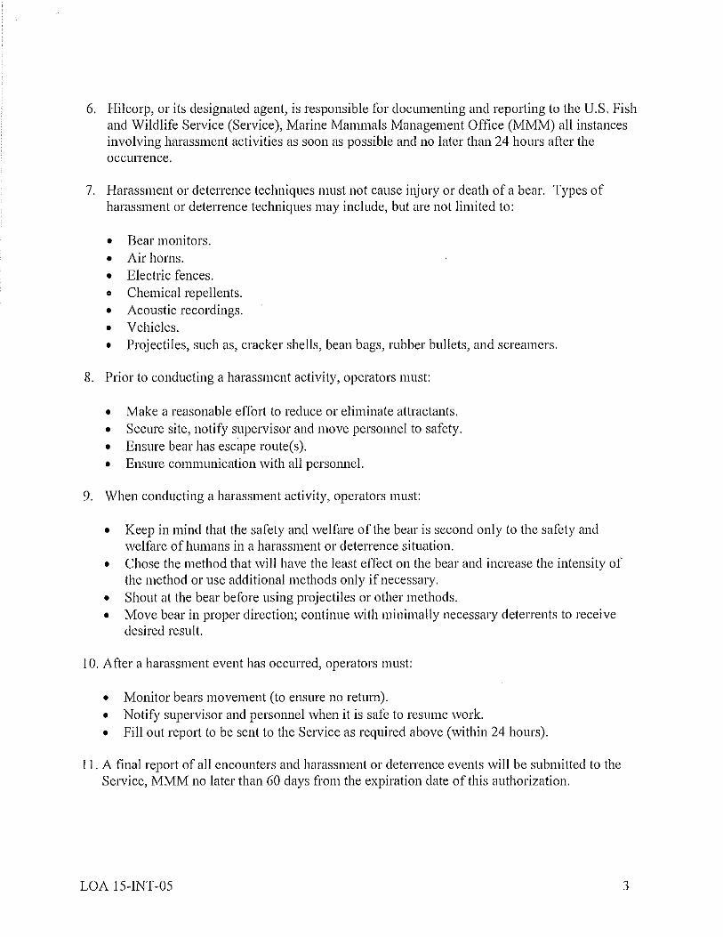
· Hilcorp Security personnel (or ACS personnel at Northstar) are required to reportall polar bear sightings and interactions to the USFWS within 24 hours. Allinstances involving harassment activities are reported as soon as possible and not laterthan 24 hours after the occurrence.
Hilcorp Security personnel will notify the USFWS of known or suspected maternal dens orbears associated with maternal dens as soon as practicable but no longer than 12 hours afterdiscovery.
Reporting
ALL POLAR BEAR SIGHTINGS AND INTERACTIONS MUST BE REPORTED TO SECURITYPERSONNEL IMMEDIATELY. Hilcorp will report all polar bear sightings and interactions to theUSFWS within 24 hours (Polar Bear Sighting Form in Appendix 6). Sightings are defined asobserved animals and any observations of tracks or scat. Tracks and scat are reported that arenew and were not observed in prior days. All instances involving harassment activities (e.g., useof cracker shells, vehicle horns, or other auditory devices; using vehicles or equipment to deterbears from an area; taking direct action to harass bears out of an area) must be reported “assoon as possible and not later than 24 hours after the occurrence”. Only qualified and trainedpersonnel approved by Hilcorp can haze polar bears.
IN ADDITION, ALL KNOWN OR SUSPECTED MATERNAL POLAR BEAR DENS OR BEARSASSOCIATED WITH A MATERNAL DEN MUST BE REPORTED TO SECURITY PERSONNELIMMEDIATELY. Security personnel will notify the USFWS as soon as practicable but not longerthan 12 hours after discovery.
Avoidance and Encounter Procedures
The main strategy for avoiding bear/human interactions is to minimize the attractiveness of worksites. The continual presence of active machinery and vehicles tends to discourage bears fromapproaching work sites, and vehicle operators are generally able to detect bears nearby. If abear should remain on-site for an extended period or if personnel are at risk, active deterrence,authorized under Sections 109(h)(1) and 112(c) of the Marine Mammal Protection Act, may benecessary. Only Security personnel or other authorized individuals, such as ACS personnel atNorthstar, are permitted to engage in active deterrence (i.e., hazing) polar bears.
Hilcorp personnel will limit encounters of polar bears by being observant of approaching animals(i.e., the use of polar bear guards) and breaking off interactions, if practicable, by allowing theanimals to continue their travel.
To further reduce the risk of an encounter, all personnel will monitor radio transmissions and/ormaintain open lines of communications with area operators to enable quick notification of thepresence of polar bears in the work vicinity. All personnel will check their work area beforeleaving the safety of a vehicle or building. If a polar bear was recently sighted in or around thework area or operating unit, personnel shall take additional precautions (e.g., posting a bearguard) to look for polar bears while working.
Hilcorp Alaska, LLC
If workers are required to be in a remote area (or off-pad), Security will be informed; Security orother assigned personnel with the appropriate level of training (see training section) mayaccompany workers if the bear risk is believed to be high. All operations conducted during hoursof darkness will be appropriately and adequately lit to see areas surrounding work location (e.g.,use of light towers and light plants). Other on-going operations, such as aerial photography andpipeline inspections, will note the presence of any bears in the area and will forward thatinformation to Security.