
Level 7, 600 Murray Street West Perth WA 6005 PO Box 273 ... · 8/25/2016 · Telfer West contains...
14
ASX : ENR 25 August 2016 Company Announcements Office Australian Securities Exchange 4th Floor, 20 Bridge Street Sydney NSW 2000 Encounter secures large scale gold opportunity at Telfer West Telfer West contains a dome of prospective stratigraphy similar to the host units at Telfer The Egg Prospect contains several areas of high grade gold mineralisation within a substantial volume of stockwork style gold mineralisation Telfer West is sparsely drill tested, particularly at depths below 100 metres, with the most recent diamond drill program completed by Newmont in 1989 Exciting new addition to the project portfolio in the Paterson Region with drilling at Telfer West scheduled to commence following the upcoming drill programs at Millennium Zinc and Lookout Rocks Copper which are due to commence in early September 2016 The directors of Encounter Resources Ltd (“Encounter” or “the Company”) are pleased to report that its ongoing review of historical exploration data has established the presence of extensive, near surface gold mineralisation at the Telfer West project (“Telfer West”). This historical exploration has confirmed a large, high quality gold exploration opportunity in a region that has demonstrated capacity to produce a major gold-copper deposit at Telfer. Background Telfer West is located 25km north-west of Newcrest’s major gold-copper operation at Telfer (Figure 1). Historical exploration at Telfer West was conducted by WMC and Newmont from 1983- 1993 targeting gold mineralisation in a similar geological setting to that of Telfer. The Telfer West Exploration licence E45/4613 (100% Encounter) has now been granted and covers an area of approximately 121km 2 . Encounter has recently flown a detailed airborne magnetic survey over the project. This survey, together with the high resolution aerial photography and historic mapping has confirmed an 8km by 5km domal formation (Figures 2 & 3) at Telfer West. The domal structure has a core of Isdell Formation overlain by the Malu Formation, Telfer Formation and sediments of the Puntapunta Formation. These geological units are the main hosts of gold-copper mineralisation at Telfer. The north-eastern limb of the dome is outcropping and was the focus of historical exploration in the 1980s. Importantly, the south-western limb of the dome and the northern fold nose extends under cover and are largely untested. Historical Gold Mineralisation at Telfer West. Historical exploration completed by WMC and Newmont focused mostly on the outcropping, north- eastern limb of Malu Formation that forms a north-west trending ridge within the project area (Figure 3). This drilling was predominantly shallow surface geochemical drilling and in total only 18 diamond drill holes have been drilled over the 8 km long trend of the dome. The shallow RAB Level 7, 600 Murray Street West Perth WA 6005 PO Box 273 West Perth WA 6872 P 08 9486 9455 F 08 6210 1578 www.enrl.com.au For personal use only
Transcript of Level 7, 600 Murray Street West Perth WA 6005 PO Box 273 ... · 8/25/2016 · Telfer West contains...
ASX : ENR 25 August 2016 Company Announcements Office Australian Securities Exchange 4th Floor, 20 Bridge Street Sydney NSW 2000
Encounter secures large scale gold opportunity at Telfer West
Telfer West contains a dome of prospective stratigraphy similar to the host units at Telfer
The Egg Prospect contains several areas of high grade gold mineralisation within a substantial volume of stockwork style gold mineralisation
Telfer West is sparsely drill tested, particularly at depths below 100 metres, with the most recent diamond drill program completed by Newmont in 1989
Exciting new addition to the project portfolio in the Paterson Region with drilling at Telfer West scheduled to commence following the upcoming drill programs at Millennium Zinc and Lookout Rocks Copper which are due to commence in early September 2016
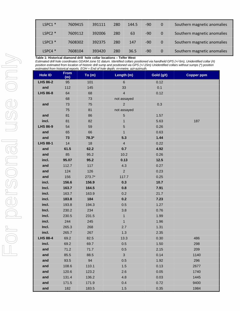
The directors of Encounter Resources Ltd (“Encounter” or “the Company”) are pleased to report that its ongoing review of historical exploration data has established the presence of extensive, near surface gold mineralisation at the Telfer West project (“Telfer West”). This historical exploration has confirmed a large, high quality gold exploration opportunity in a region that has demonstrated capacity to produce a major gold-copper deposit at Telfer. Background Telfer West is located 25km north-west of Newcrest’s major gold-copper operation at Telfer (Figure 1). Historical exploration at Telfer West was conducted by WMC and Newmont from 1983-1993 targeting gold mineralisation in a similar geological setting to that of Telfer. The Telfer West Exploration licence E45/4613 (100% Encounter) has now been granted and covers an area of approximately 121km2. Encounter has recently flown a detailed airborne magnetic survey over the project. This survey, together with the high resolution aerial photography and historic mapping has confirmed an 8km by 5km domal formation (Figures 2 & 3) at Telfer West. The domal structure has a core of Isdell Formation overlain by the Malu Formation, Telfer Formation and sediments of the Puntapunta Formation. These geological units are the main hosts of gold-copper mineralisation at Telfer. The north-eastern limb of the dome is outcropping and was the focus of historical exploration in the 1980s. Importantly, the south-western limb of the dome and the northern fold nose extends under cover and are largely untested. Historical Gold Mineralisation at Telfer West. Historical exploration completed by WMC and Newmont focused mostly on the outcropping, north-eastern limb of Malu Formation that forms a north-west trending ridge within the project area (Figure 3). This drilling was predominantly shallow surface geochemical drilling and in total only 18 diamond drill holes have been drilled over the 8 km long trend of the dome. The shallow RAB
Level 7, 600 Murray Street
West Perth WA 6005
PO Box 273
West Perth WA 6872
P 08 9486 9455
F 08 6210 1578
www.enrl.com.au
For
per
sona
l use
onl
y

and RC drilling totalled 351 holes with only 3 of these holes exceeding 100m depth, 26 holes drilled to a depth between 65 and 100m, 68 holes drilled between depths of 25 and 65m and the remaining 254 holes drilled to less than 25m depth. The majority of the 18 diamond drill holes focused on testing magnetic anomalies in the southern part of the dome where strong copper anomalism was identified (Figure 3). The limited remaining diamond drilling was designed to test areas of surface geochemical and geophysical anomalism in the northern part of the project area (Figure 2 and 3). These diamond drill holes intersected gold mineralisation including zones of broad, low grade gold-copper-arsenic anomalism and also narrow bands of high grade gold mineralisation. Only 5 of the 18 diamond holes were drilled deeper that 150m and several holes ended in gold anomalism. The review of historical exploration data is continuing. However, an area of immediate focus that warrants near term follow up is the Egg Prospect, located on the north-eastern limb of the dome at Telfer West. Four diamond holes were drilled at the Egg Prospect in the period 1986 to 1989 with three of these diamond holes drilled on a single section (Figure 4). Two of the three drill holes are of particular interest:
Drill hole LHS86-9 was drilled in a south-west direction, perpendicular to interpreted stratigraphy. This hole was abandoned at 78.3m due to mechanical failure but ended in 5.3m at 1.44g/t gold from 73m to EOH.
A follow up hole LHS88-1 was drilled in a north-east direction and as such is interpreted to be drilled down the stratigraphy. However, this hole intersected a broad zone of low grade stockwork mineralisation of 117.7m @ 0.25g/t gold from 156m to EOH and included several narrow zones of high grade gold mineralisation:
0.7m @ 4.92g/t gold from 61.5m
0.13m @ 12.5g/t gold from 95.07m
0.3m @ 10.7g/t gold from 156.6m
0.8m @ 7.91g/t gold from 163.7m incl. 0.2m @ 21.7g/t gold from 163.7m and
0.2m @ 7.23g/t gold from 183.8m The fourth hole at Egg (LHS86-8) was drilled approximately 100m to the north-west and parallel to LHS 86-9. This 140m deep hole was not extensively sampled but did return an intersection of 5m @ 1.57g/t gold from 81m including 1m @ 5.63g/t from 81m. It is interpreted that this historical drilling at the Egg prospect has identified a substantial volume of stockwork style gold mineralisation within the Malu Formation (see Photo 1). This mineralisation remains open and untested in all directions and at depth. In addition, there are only 2 diamond drill holes that have been drilled north-west of the Egg prospect. Drill hole LHS86-2 was drilled following up an anomalous surface rock chip sample, collected on the edge of the outcropping Malu Formation, approximately 2km north-west of the Egg prospect. This drill hole was drilled to a depth of 152.2m and ended in a broad zone of elevated gold anomalism (0.1 – 0.2 g/t gold). A further 1.6km to the north-west, a single diamond drill hole, LHS89-6, was drilled to test a magnetic anomaly located under approximately 60m of cover, along the interpreted fold axis of the dome. This hole was drilled to a depth of 107 metres. The drill hole did not explain the magnetic anomaly however it did intersect a broad zone of gold anomalism including zones of higher grade gold including:
8.7m @ 0.41g/t gold from 66m
0.8m @ 6.49g/t gold from 98.2m.
3.0m @ 0.23g/t gold from 104m to EOH
For
per
sona
l use
onl
y

In conclusion, the review of the historical exploration at Telfer West has identified a large, high quality gold exploration project. The context of the opportunity is important:
Telfer West contains a mostly untested dome of prospective stratigraphy similar to the host units at Telfer.
The Egg Prospect within the Malu Formation contains several areas of high grade gold mineralisation with anomalism extending for at least 4km to the north-west.
Telfer West is sparsely drill tested, particularly at depths below 100 metres, with the most recent diamond drill program completed by Newmont in 1989.
Upcoming Activity Given the context and location of the gold opportunity at Telfer West, follow up exploration is planned to commence as soon as possible with two areas of focus: 1. Follow up the incomplete exploration program conducted in the 1980s using current
geophysical tools and contemporary understanding of the mineralising event at Telfer. This will also include following up the historical end of hole gold mineralised intersections.
2. Systematically explore the interpreted untested undercover western limb of prospective stratigraphy and test the fold axis of the anticline where this position extends under cover to the north-west.
In addition, whilst the historical review is ongoing, the Company is evaluating the completion of an IP (induced polarisation) survey at Telfer West. This is an exciting new addition to the project portfolio in the Paterson Region. First drilling by Encounter at Telfer West is scheduled to commence following the upcoming planned drill programs at Millennium Zinc and Lookout Rocks Copper commencing in September 2016. As such we anticipate that drilling at Telfer West will commence in October-November 2016.
Hole_ID Northing
(m) Easting
(m) RL (m)
EOH(m) Dip Azi Comment
LHS86-2 7612633 389135 275 152.5 -45 180 Northern fold nose target
LHS86-3 * 7609605 390917 279 307 -90 0 Southern magnetic anomalies
LHS86-8 # 7611312 390692 310 140 -50 220 Egg Prospect
LHS86-9 7611282 390804 318 78.3 -50 220 Egg Prospect
LHS88-1 7611128 390674 285 273.7 -50 38 Egg Prospect
LHS88-4 * 7609324 391182 279 243.2 -60 308 Southern magnetic anomalies
LHS88-4a * 7609292 391217 279 80.9 -60 308 Southern magnetic anomalies
LHS88-7 7611141 391920 289 155.3 -50 308 Stuttgart Prospect
LHS89-1 # 7609610 391221 278 80 -50 355 Southern magnetic anomalies
LHS89-2 # 7609814 391177 279 80 -50 355 Southern magnetic anomalies
LHS89-3 # 7610004 391157 276 80 -50 175 Southern magnetic anomalies
LHS89-4 # 7610214 391137 278 90 -50 175 Southern magnetic anomalies
LHS89-5 7611047 390669 280 125.8 -50 40 Egg Prospect
LHS89-6 7613623 387812 260 107 -50 40 Northern magnetic anomaly
For
per
sona
l use
onl
y
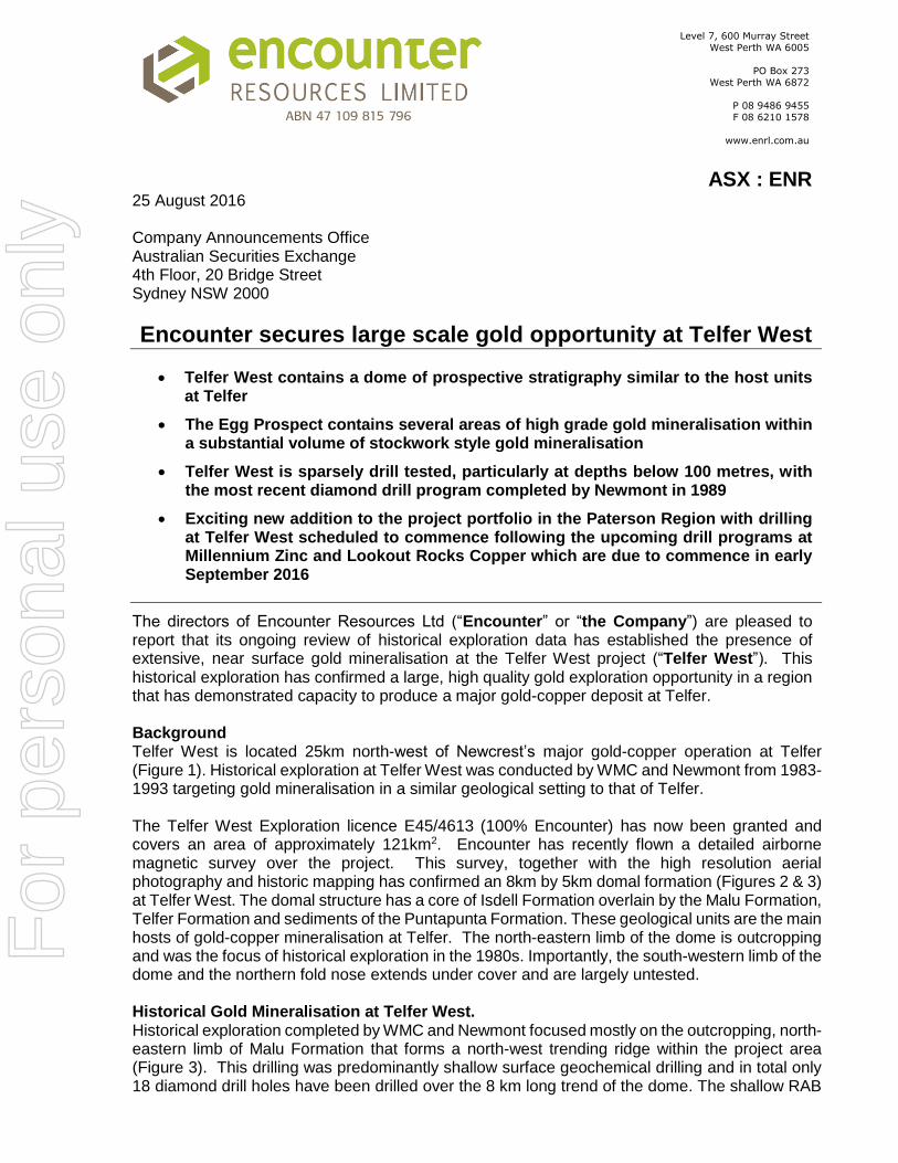
LSPC1 * 7609415 391111 280 144.5 -90 0 Southern magnetic anomalies
LSPC2 * 7609112 392006 280 63 -90 0 Southern magnetic anomalies
LSPC3 * 7608302 392375 280 147 -90 0 Southern magnetic anomalies
LSPC4 * 7608104 393420 280 36.5 -90 0 Southern magnetic anomalies
Table 1: Historical diamond drill hole collar locations – Telfer West Estimated drill hole coordinates GDA94 zone 51 datum. Identified collars positioned via handheld GPS (+/-5m), Unidentified collar (#) position estimated from location of historic drill sump and positioned via GPS (+/-15m) Unidentified collars without sumps (*) position estimated from historical reports. EOH = End of hole depth; m=metre; azi=azimuth.
Hole ID From (m)
To (m) Length (m) Gold (g/t) Copper ppm
LHS 86-2 95 101 6 0.12
and 112 145 33 0.1
LHS 86-8 64 68 4 0.12
68 73 not assayed
and 73 75 2 0.3
75 81 not assayed
and 81 86 5 1.57
incl. 81 82 1 5.63 187
LHS 86-9 54 59 5 0.26
and 65 66 1 0.63
and 73 78.3* 5.3 1.44
LHS 88-1 14 18 4 0.22
and 61.5 62.2 0.7 4.92
and 85 95.2 10.2 0.26
incl. 95.07 95.2 0.13 12.5
and 112.7 117 4.3 0.27
and 124 126 2 0.23
and 156 273.7* 117.7 0.25
incl. 156.6 156.9 0.3 10.7
Incl. 163.7 164.5 0.8 7.91
incl. 163.7 163.9 0.2 21.7
incl. 183.8 184 0.2 7.23
incl. 193.8 194.3 0.5 1.27
Incl. 230.2 234 3.8 0.76
incl. 230.5 231.5 1 1.99
incl. 244 245 1 1.96
Incl. 265.3 268 2.7 1.31
incl. 265.7 267 1.3 2.35
LHS 88-4 69.2 82.5 13.3 0.30 486
incl. 69.2 69.7 0.5 1.50 298
and 71.2 71.7 0.5 2.15 209
and 85.5 88.5 3 0.14 1140
and 93.5 94 0.5 1.92 296
and 108.6 110.1 1.5 0.13 2677
and 120.6 123.2 2.6 0.05 1740
and 131.4 136.2 4.8 0.03 1445
and 171.5 171.9 0.4 0.72 9400
and 182 183.5 1.5 0.35 1984
For
per
sona
l use
onl
y

LHS 88-4a 67.4 80.9* 13.5 0.32 502
incl. 79 80 1 1.23 1240
LHS 88-7 30.7 31.7 1 1.60
and 39.8 40.3 0.5 1.05 262
and 60 62 2 0.37
and 115.8 118 2.2 0.67 278
and 150 154 4 0.12 175
LHS 89-6 66 74.7 8.7 0.41 106
incl. 69.8 70.7 0.9 2.45 190
and 83.2 84 0.8 1.07 670
and 98.2 99 0.8 6.49 235
and 104 107* 3 0.23 266
LSPC 1 61 66.2 5.2 0.25 728
and 72.5 79.8 7.3 0.13 309
and 96.6 106.9 10.3 0.68 402
incl. 96.6 97.1 0.5 10.49 443
and 117.3 130.2 12.9 0.59 1966
incl. 127.4 130.2 2.8 2.14 2823
LSPC 3 42 57 15 0.04 2175
Table 2: Historical diamond drilling assay results – Telfer West Intervals are calculated at a 0.1 g/t Au lower cut-off and in excess of 0.5gm. Some internal lower grade (>0.1g/t Au) are included in the composite calculations. Internal higher grade intervals calculated at a 1g/t Au lower cut-off. Associated copper results above 100ppm included. * = bottom of hole intersection
Figure 1: Telfer West location map – Google Earth background
Telfer Gold-Copper Mine
Telfer West Project E45/4613
(100% ENR)
For
per
sona
l use
onl
y
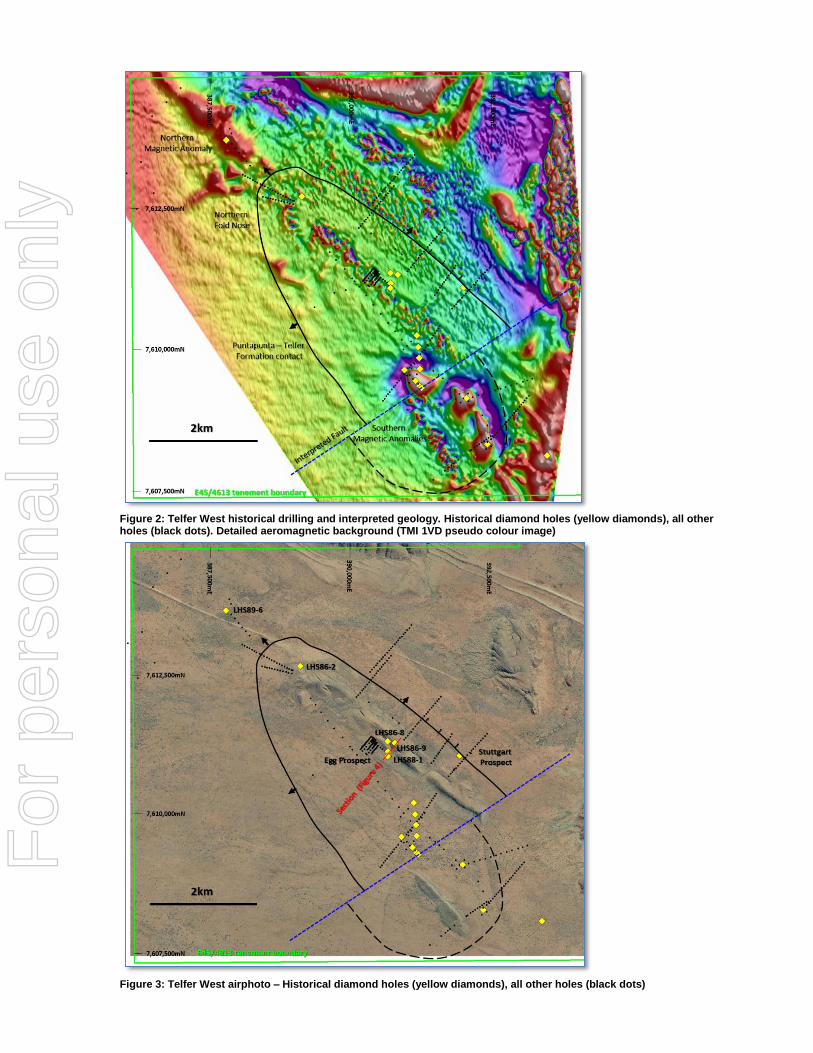
Figure 2: Telfer West historical drilling and interpreted geology. Historical diamond holes (yellow diamonds), all other holes (black dots). Detailed aeromagnetic background (TMI 1VD pseudo colour image)
Figure 3: Telfer West airphoto – Historical diamond holes (yellow diamonds), all other holes (black dots)
For
per
sona
l use
onl
y
Figure 4: Egg Prospect cross section from historical report
Photo 1: Egg Prospect LHS 86-9 from ~65m to EOH (note incomplete sampling)
For
per
sona
l use
onl
y
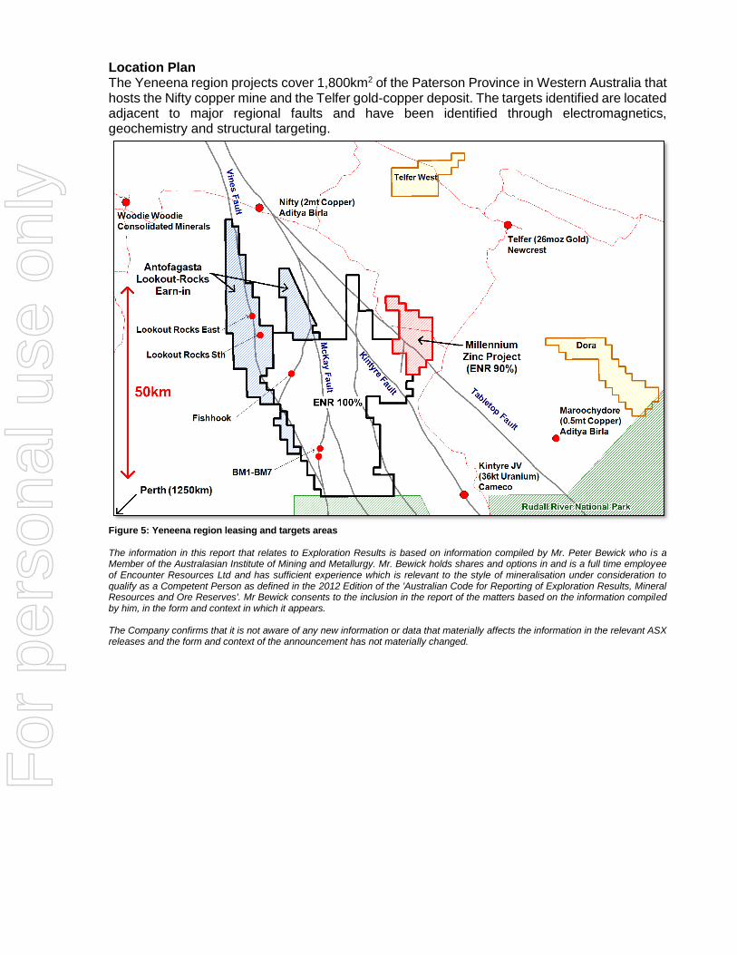
Location Plan The Yeneena region projects cover 1,800km2 of the Paterson Province in Western Australia that hosts the Nifty copper mine and the Telfer gold-copper deposit. The targets identified are located adjacent to major regional faults and have been identified through electromagnetics, geochemistry and structural targeting.
Figure 5: Yeneena region leasing and targets areas The information in this report that relates to Exploration Results is based on information compiled by Mr. Peter Bewick who is a Member of the Australasian Institute of Mining and Metallurgy. Mr. Bewick holds shares and options in and is a full time employee of Encounter Resources Ltd and has sufficient experience which is relevant to the style of mineralisation under consideration to qualify as a Competent Person as defined in the 2012 Edition of the 'Australian Code for Reporting of Exploration Results, Mineral Resources and Ore Reserves'. Mr Bewick consents to the inclusion in the report of the matters based on the information compiled by him, in the form and context in which it appears. The Company confirms that it is not aware of any new information or data that materially affects the information in the relevant ASX releases and the form and context of the announcement has not materially changed.
For
per
sona
l use
onl
y
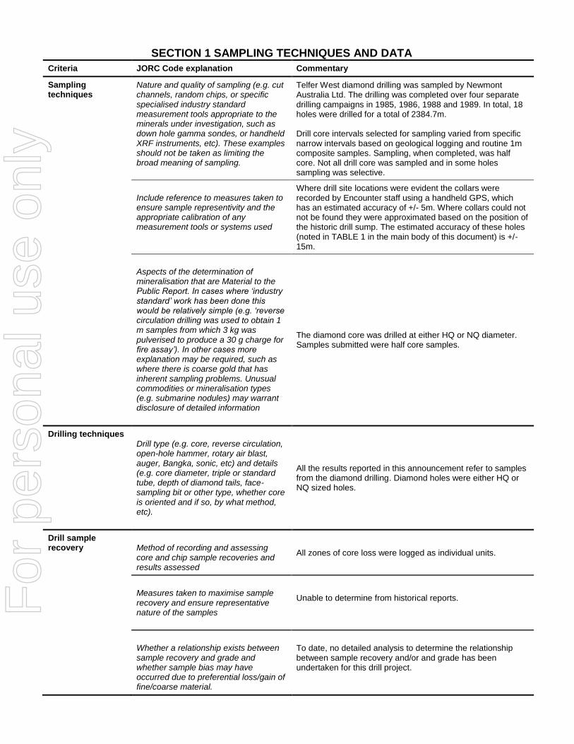
SECTION 1 SAMPLING TECHNIQUES AND DATA
Criteria JORC Code explanation Commentary
Sampling techniques
Nature and quality of sampling (e.g. cut channels, random chips, or specific specialised industry standard measurement tools appropriate to the minerals under investigation, such as down hole gamma sondes, or handheld XRF instruments, etc). These examples should not be taken as limiting the broad meaning of sampling.
Telfer West diamond drilling was sampled by Newmont Australia Ltd. The drilling was completed over four separate drilling campaigns in 1985, 1986, 1988 and 1989. In total, 18 holes were drilled for a total of 2384.7m. Drill core intervals selected for sampling varied from specific narrow intervals based on geological logging and routine 1m composite samples. Sampling, when completed, was half core. Not all drill core was sampled and in some holes sampling was selective.
Include reference to measures taken to ensure sample representivity and the appropriate calibration of any measurement tools or systems used
Where drill site locations were evident the collars were recorded by Encounter staff using a handheld GPS, which has an estimated accuracy of +/- 5m. Where collars could not not be found they were approximated based on the position of the historic drill sump. The estimated accuracy of these holes (noted in TABLE 1 in the main body of this document) is +/- 15m.
Aspects of the determination of mineralisation that are Material to the Public Report. In cases where ‘industry standard’ work has been done this would be relatively simple (e.g. ‘reverse circulation drilling was used to obtain 1 m samples from which 3 kg was pulverised to produce a 30 g charge for fire assay’). In other cases more explanation may be required, such as where there is coarse gold that has inherent sampling problems. Unusual commodities or mineralisation types (e.g. submarine nodules) may warrant disclosure of detailed information
The diamond core was drilled at either HQ or NQ diameter. Samples submitted were half core samples.
Drilling techniques Drill type (e.g. core, reverse circulation, open-hole hammer, rotary air blast, auger, Bangka, sonic, etc) and details (e.g. core diameter, triple or standard tube, depth of diamond tails, face-sampling bit or other type, whether core is oriented and if so, by what method, etc).
All the results reported in this announcement refer to samples from the diamond drilling. Diamond holes were either HQ or NQ sized holes.
Drill sample recovery
Method of recording and assessing core and chip sample recoveries and results assessed
All zones of core loss were logged as individual units.
Measures taken to maximise sample recovery and ensure representative nature of the samples
Unable to determine from historical reports.
Whether a relationship exists between sample recovery and grade and whether sample bias may have occurred due to preferential loss/gain of fine/coarse material.
To date, no detailed analysis to determine the relationship between sample recovery and/or and grade has been undertaken for this drill project.
For
per
sona
l use
onl
y

Criteria JORC Code explanation Commentary
Logging
Whether core and chip samples have been geologically and geotechnically logged to a level of detail to support appropriate Mineral Resource estimation, mining studies and metallurgical studies.
Geological logging is carried out on all drill holes by Newmont geologists, with lithology, alteration, structure and sulphide recorded. Based on the information available in the historical reports these diamond holes were not orientated.
Whether logging is qualitative or quantitative in nature. Core (or costean, channel, etc) photography.
Geological logging is qualitative in nature and records interpreted lithology, alteration, mineralisation, structure, veining and other features of the samples.
The total length and percentage of the relevant intersections logged
All drill holes were logged in full by Newmont geologists.
Sub-sampling techniques and sample preparation
If core, whether cut or sawn and whether quarter, half or all core taken.
The core samples reported in this announcement were half cut core.
If non-core, whether riffled, tube sampled, rotary split, etc and whether sampled wet or dry.
Core samples
For all sample types, the nature, quality and appropriateness of the sample preparation technique.
Unable to verify from historical geological reports.
Quality control procedures adopted for all sub-sampling stages to maximise representivity of samples.
No QAQC samples were submitted with these holes.
Measures taken to ensure that the sampling is representative of the in situ material collected, including for instance results for field duplicate/second-half sampling.
No duplicate samples were submitted with these holes
Whether sample sizes are appropriate to the grain size of the material being sampled.
The sample sizes are considered appropriate to give an accurate indication of the gold and base metal anomalism and mineralisation at Telfer West.
Quality of assay data and laboratory tests
The nature, quality and appropriateness of the assaying and laboratory procedures used and whether the technique is considered partial or total.
No information is available in the historic reports on the nature of the assaying completed.
For geophysical tools, spectrometers, handheld XRF instruments, etc, the parameters used in determining the analysis including instrument make and model, reading times, calibrations factors applied and their derivation, etc.
No Geophysical tools used
Nature of quality control procedures adopted (e.g. standards, blanks, duplicates, external laboratory checks) and whether acceptable levels of accuracy (i.e. lack of bias) and precision have been established.
No information is available in the historic reports on laboratory QAQC procedures.
For
per
sona
l use
onl
y
Criteria JORC Code explanation Commentary
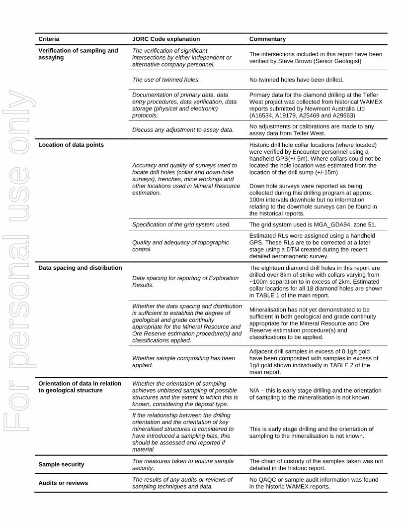
Verification of sampling and assaying
The verification of significant intersections by either independent or alternative company personnel.
The intersections included in this report have been verified by Steve Brown (Senior Geologist)
The use of twinned holes. No twinned holes have been drilled.
Documentation of primary data, data entry procedures, data verification, data storage (physical and electronic) protocols.
Primary data for the diamond drilling at the Telfer West project was collected from historical WAMEX reports submitted by Newmont Australia Ltd (A16534, A19179, A25469 and A29563)
Discuss any adjustment to assay data.
No adjustments or calibrations are made to any assay data from Telfer West.
Location of data points
Accuracy and quality of surveys used to locate drill holes (collar and down-hole surveys), trenches, mine workings and other locations used in Mineral Resource estimation.
Historic drill hole collar locations (where located) were verified by Encounter personnel using a handheld GPS(+/-5m). Where collars could not be located the hole location was estimated from the location of the drill sump (+/-15m) Down hole surveys were reported as being collected during this drilling program at approx. 100m intervals downhole but no information relating to the downhole surveys can be found in the historical reports.
Specification of the grid system used. The grid system used is MGA_GDA94, zone 51.
Quality and adequacy of topographic control.
Estimated RLs were assigned using a handheld GPS. These RLs are to be corrected at a later stage using a DTM created during the recent detailed aeromagnetic survey.
Data spacing and distribution
Data spacing for reporting of Exploration Results.
The eighteen diamond drill holes in this report are drilled over 8km of strike with collars varying from ~100m separation to in excess of 2km. Estimated collar locations for all 18 diamond holes are shown in TABLE 1 of the main report.
Whether the data spacing and distribution is sufficient to establish the degree of geological and grade continuity appropriate for the Mineral Resource and Ore Reserve estimation procedure(s) and classifications applied.
Mineralisation has not yet demonstrated to be sufficient in both geological and grade continuity appropriate for the Mineral Resource and Ore Reserve estimation procedure(s) and classifications to be applied.
Whether sample compositing has been applied.
Adjacent drill samples in excess of 0.1g/t gold have been composited with samples in excess of 1g/t gold shown individually in TABLE 2 of the main report.
Orientation of data in relation to geological structure
Whether the orientation of sampling achieves unbiased sampling of possible structures and the extent to which this is known, considering the deposit type.
N/A – this is early stage drilling and the orientation of sampling to the mineralisation is not known.
If the relationship between the drilling orientation and the orientation of key mineralised structures is considered to have introduced a sampling bias, this should be assessed and reported if material.
This is early stage drilling and the orientation of sampling to the mineralisation is not known.
Sample security The measures taken to ensure sample security.
The chain of custody of the samples taken was not detailed in the historic report.
Audits or reviews The results of any audits or reviews of sampling techniques and data.
No QAQC or sample audit information was found in the historic WAMEX reports.
For
per
sona
l use
onl
y

SECTION 2 REPORTING OF EXPLORATION RESULTS
Criteria JORC Code explanation Commentary
Mineral tenement and land tenure status
Type, reference name/number, location and ownership including agreements or material issues with third parties including joint ventures, partnerships, overriding royalties, native title interests, historical sites, wilderness or national park and environmental settings.
The Telfer West project is located within the tenement E45/4613 which is 100% held by Encounter. The prospect area is subject to a production royalty of A$1 per dry metric tonne of ore mined. This tenement is contained completely within land where the Martu People have been determined to hold native title rights. No historical or environmentally sensitive sites have been identified in the area of work.
Exploration done by other parties
Acknowledgment and appraisal of exploration by other parties.
A regional LAG sampling program in the early 1980s conducted by WMC Resources identified a copper / arsenic anomaly over the area of the Telfer West project. Detailed mapping and ~2km spaced, shallow bedrock drilling by WMC was completed to produce a interpreted geology map of the area. Anomalous values of 150-520ppm As with no gold and low tenor copper values were recorded. In 1983 Newmont Holdings Pty Ltd (later Newmont Australia Ltd) entered into a joint venture with WMC over the Telfer West area. In 1984 Newmont and BHP entered an agreement with WMC to continue the joint venture with Newmont as operator. Newmont completed a regional aeromagnetic and radiometric survey in 1984 and colour photography survey. 144 rock chip samples and a bulk stream sediment sampling was also completed prior to a 15 hole RC drill program (total of 756m, LSR series) targeting the Upper Malu/ Puntapunta contact. RC Holes were drilled on four 400m spaced sections at ~40m spacing on the north-east side of the interpreted dome. No mineralized reef positions were identified in this program. In 1985, Newmont completed 4 diamond holes (LSPC 1-4) for a total of 391m in the south of the dome testing separate magnetic anomalies. Drilling returned encouraging results with Au-Cu-W ‘skarn style’ mineralization hosted in the Isdell Formation. In 1986, RAB drilling at the Egg prospect totaled 63 holes for 1175m over an area approx. 400m by 400m (ERG series). Sampling was limited to two samples per hole, one at the base of cover and one at the bottom of the hole. Four diamond holes (LHS86 series) for 677m were drilled across the project testing the Egg, Southern Magnetic anomaly and the northern Malu fold nose. Better results from this program are reported in TABLE 2 of the main report. In 1987, the JV partners completed 13 (LSR 1-13) RAB holes for 379m along a single 1200m long east-west line in the south of the project. RC drilling (LSR 87 series) of 16 holes for 1383 were drilled in the vicinity of the southern magnetic anomalies. It is unclear at this stage if this drilling effectively tested the magnetic features. In 1988, Newmont completed 4 diamond holes
For
per
sona
l use
onl
y
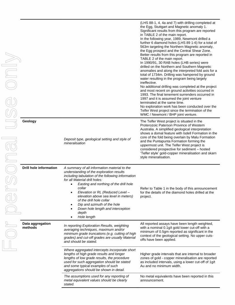
(LHS 88-1, 4, 4a and 7) with drilling completed at the Egg, Stuttgart and Magnetic anomaly 1. Significant results from this program are reported in TABLE 2 of the main report. In the following year, 1989, Newmont drilled a further 6 diamond holes (LHS 89 1-6) for a total of 563m targeting the Northern Magnetic anomaly, the Egg prospect and the Central Shear Zone. Better results from this program are reported in TABLE 2 of the main report. In 1990/91, 30 RAB holes (LHB series) were drilled on the Northern and Southern Magnetic anomalies and along the interpreted fold axis for a total of 1734m. Drilling was hampered by ground water resulting in the program being largely ineffective. No additional drilling was completed at the project and most recent on ground activities occurred in 1993. The final tenement surrenders occurred in 1997 and it is assumed the joint venture terminated at the same time. No exploration work has been conducted over the Telfer West project since the termination of the WMC / Newmont / BHP joint venture.
Geology
Deposit type, geological setting and style of mineralisation
The Telfer West project is situated in the Proterozoic Paterson Province of Western Australia. A simplified geological interpretation shows a domal feature with Isdell Formation in the core of the fold being overlain by Malu Formation and the Puntapunta Formation forming the uppermost unit. The Telfer West project is considered prospective for sediment – hosted ‘Telfer style’ gold-copper mineralisation and skarn style mineralisation.
Drill hole information A summary of all information material to the understanding of the exploration results including tabulation of the following information for all Material drill holes:
Easting and northing of the drill hole collar
Elevation or RL (Reduced Level – elevation above sea level in meters) of the drill hole collar
Dip and azimuth of the hole
Down hole length and interception depth
Hole length
Refer to Table 1 in the body of this announcement for the details of the diamond holes drilled at the project.
Data aggregation methods
In reporting Exploration Results, weighting averaging techniques, maximum and/or minimum grade truncations (e.g. cutting of high grades) and cut-off grades are usually Material and should be stated.
All reported assays have been length weighted, with a nominal 0.1g/t gold lower cut-off with a minimum of 0.5gm reported as significant in the context of the geological setting. No upper cuts-offs have been applied.
Where aggregated intercepts incorporate short lengths of high grade results and longer lengths of low grade results, the procedure used for such aggregation should be stated and some typical examples of such aggregations should be shown in detail.
Higher grade intervals that are internal to broader zones of gold - copper mineralisation are reported as included intervals, using a lower cut-off of 1g/t Au and no minimum width.
The assumptions used for any reporting of metal equivalent values should be clearly stated.
No metal equivalents have been reported in this announcement.
For
per
sona
l use
onl
y

Criteria JORC Code explanation Commentary
Relationship between mineralisation widths and intercept lengths
These relationships are particularly important in the reporting of exploration results. If the geometry of the mineralisation with respect to the drill hole angle is known, its nature should be reported. If it is not known and only the down hole lengths are reported, there should be a clear statement to this effect (e.g. ‘down hole length, true width not known’).
The geometry of the mineralisation is not yet known due to insufficient drilling in the targeted area.
Diagrams Appropriate maps and sections (with scales) and tabulations of intercepts should be included for any significant discovery being reported. These should include, but not be limited to a plane view of drill hole collar locations and appropriate sectional views.
Refer to body of this announcement.
Balanced Reporting Where comprehensive reporting of all Exploration Results is not practical, representative reporting of both low and high grades and/or widths should be practiced to avoid misleading reporting of Exploration Results.
All significant intervals are reported with a 0.1g/t Au lower cut-off with a minimum threshold of 0.5gm (internal higher grade intervals quoted at a 1g/t Au lower cut-off).
Other substantive exploration data
Other exploration data, if meaningful and material, should be reported including (but not limited to): geological observation; geophysical survey results; geochemical survey results; bulk samples – size and method of treatment; metallurgical test results; bulk density, groundwater, geotechnical and rock characteristics; potential deleterious or contaminating substances.
All meaningful and material information has been included in the body of the text. No metallurgical or mineralogical assessments have been completed.
Further Work
The nature and scale of planned further work (e.g. tests for lateral extensions or depth extensions or large – scale step – out drilling). Diagrams clearly highlighting the areas of possible extensions, including the main geological interpretations and future drilling areas, provided this information is not commercially sensitive.
Future work programs are currently being designed and will be reported in the coming months.
For
per
sona
l use
onl
y