Lesson Resource Kit: Building the Rideau Canal
18
Page | 1 Lesson Resource Kit: Building the Rideau Canal Grade 7: 1800–1850: Conflict and Challenges Lock, Blockhouse at the Narrows, Rideau Lake - the first descent from Summit towards Bytown, painted by Thomas Burrowes, 1841 Thomas Burrowes fonds Reference Code: C 1-0-0-0-27 Archives of Ontario, I0002146 Introduction Designed to fit into teachers’ practice, this resource kit provides links, activity suggestions, primary source handouts and worksheets to assist you and your students in applying, inquiring, and understanding Canada between 1800 and 1850. Topic Settlement, trade, and the development of the Rideau Canal Source Click here to visit the Eyewitness: Thomas Burrowes on the Rideau Canal online exhibit Use the Archives of Ontario’s online exhibit: As a learning resource for yourself As a site to direct your students for inquiry projects As a place to find and use primary sources related to the curriculum
Transcript of Lesson Resource Kit: Building the Rideau Canal
Page | 1
Lesson Resource Kit: Building the Rideau Canal
Grade 7: 1800–1850: Conflict and Challenges
Lock, Blockhouse at the Narrows, Rideau Lake - the first descent from Summit towards
Bytown, painted by Thomas Burrowes, 1841
Thomas Burrowes fonds
Reference Code: C 1-0-0-0-27
Archives of Ontario, I0002146
Introduction
Designed to fit into teachers’ practice, this resource kit provides links, activity
suggestions, primary source handouts and worksheets to assist you and your students
in applying, inquiring, and understanding Canada between 1800 and 1850.
Topic
Settlement, trade, and the development of the Rideau Canal
Source
Click here to visit the Eyewitness: Thomas Burrowes on the Rideau Canal online exhibit
Use the Archives of Ontario’s online exhibit:
As a learning resource for yourself
As a site to direct your students for inquiry projects
As a place to find and use primary sources related to the curriculum

Page | 2
Themes that can be addressed
Use of Primary Sources
Transportation infrastructure, industrialization and trade in early nineteenth
century Upper and Lower Canada
Immigration and settlement of Upper and Lower Canada in the early nineteenth
century
The War of 1812
Curriculum
Strand B. Canada, 1800–1850: Conflict and challenges
Overall Expectations Historical Thinking Concepts Specific Expectations
B1. Application: Changes
and Challenges
Continuity and Change;
Historical Perspective
B1.2
B2. Inquiry: Perspectives
in British North Americans
Historical Perspective;
Historical Significance
B2.4, B2.6
B3. Understanding
Historical Context: Events
and Their Consequence
Historical Significance;
Cause and Consequence
B3.3, B3.5
Page | 3
Assignment & Activity Ideas
Inquiring into the Building of the Rideau Canal
The historical inquiry process involves five steps:
Formulating a question
Gathering and organizing information or evidence
Interpreting and analysing information or evidence
Evaluating information or evidence and drawing conclusions
Communicating findings
The curriculum highlights that these steps do not have to be completed
sequentially nor together. You may wish to explore specific steps based on your
students’ readiness and prior knowledge or your own resources and time. See
pages 22-24 in the 2013 revised Ontario Social Studies and History curriculum
for more details by clicking here.
Using a primary source handout from this kit, introduce your students to the topic
of the Rideau Canal and its place in building Canada. Ask students to ask
questions of the primary source provided. Use these questions as a jumping off
point to explore these historical issues of life in rural communities during this time
period in more depth.
Access the Eyewitness: Thomas Burrowes on the Rideau Canal online exhibit by
clicking here and use the online exhibit as a source to point your students for
their own inquiry project. Here, they can view primary sources and secondary
information to gather and organize historical information that they can interpret,
evaluate, and communicate for different end products.
The Locks: Changes and challenges
Learning about the Rideau Cancel is an excellent way to introduce your students
to the concepts of continuity and change and cause and consequence
Use the primary sources included in this kit to illustrate the historical context of
this undertaking and to discuss how different the landscape looked then versus
now.
Have students discuss a comparable public undertaking and create their own
watercolours to compare and contrast.
Alternatively, ask students to find modern pictures of the sites that Burrows
painted. How have things changed and stayed the same over the years?
Page | 4
Picture Yourself at the Locks
Using one of the Burrows’ watercolour primary sources, ask your students to
picture themselves at the locks and write a letter describing the causes and
consequences of creating the canal system OR the changes and continuity of the
landscape following construction
Alternatively, ask students to draw a picture connected to one of the primary
sources demonstrating the landscape before and after lock construction.
Page | 5
Handouts & Worksheets
Introduction to Primary Sources ...................................................................................... 6
Rideau Canal: National Historic Site of Canada .............................................................. 7
The Need for a Safe Route to Upper Canada ................................................................. 7
Lower Bytown and Sappers’ Bridge (1845) ..................................................................... 9
Eastern End of Rideau Canal (1830)............................................................................. 10
Dam at Jones’ Falls (1841) ........................................................................................... 11
Opinicon Lake (1840) .................................................................................................... 12
Honourable Thomas McKay’s Mills (1845) .................................................................... 13
Canoe Heading Towards Bytown .................................................................................. 14
Rocky cut at the Isthmus to join Rideau Lake ............................................................... 15
The last ascent to the Summit Water of Canal from Lake Ontario ................................ 16
Lock at Chaffey’s Mills ................................................................................................... 17
Brewer’s Lower Mill ....................................................................................................... 18

Page | 6
Introduction to Primary Sources
A primary source is a document or object from the past created by people who lived
during that time. Primary sources provide a view into an event or experience that only
people living during that time could have experienced.
Archives collect and preserve primary sources so that students can learn history from
the experiences of people who were there. At an archive, primary sources are called
records. At a museum, primary sources are called artifacts.
Have you ever used a primary source before?
Primary Sources Secondary Sources
Original material from the past Material people today write about the past
Example: Letters Diaries
Photographs Paintings and other art work
Graphs Maps
Example: Textbooks
Reference books Websites such as Wikipedia
Current news articles Documentaries and films
What are some other examples of primary and secondary sources?
Can sources be both primary and secondary?
Page | 7
Rideau Canal: National Historic Site of Canada
The Need for a Safe Route to Upper Canada
The American Revolution created a hostile country to the south of Great Britain's
Canadian colonies. For many decades after the establishment of the United States,
Americans believed that the conquest of Canada was a piece of unfinished business left
over from the revolutionary war. In the event of war, the colony of Upper Canada
(present-day Ontario) was at particular risk along the St. Lawrence River from Montreal
to Kingston. The river route, vital for the transportation of goods and people to and from
the Great Lakes area, was easily cut off because much of the southern shore of the
river was in American possession.
Planning the Rideau Canal System
Following the War of 1812, surveys were carried out to identify a second, safe, route
from Montreal to the Great Lakes. The decision was to follow the Ottawa River from
Montreal to the mouth of the Rideau River, at present day Ottawa, then travel south
along the Rideau and through a series of small lakes to the Cataraqui River which
emptied into Lake Ontario at Kingston. Unfortunately, the route selected was navigable
only in parts and to use it for boats larger than a canoe necessitated the construction of
a series of locks between Ottawa to Kingston. Given the expense of such an
undertaking, the project met with little enthusiasm with the British authorities.
A champion of the building of a canal arose in the person of the Duke of Wellington,
famous as the victor over Napoleon at the battle of Waterloo and an influential voice in
British politics. The result of his support was the appointment of Lieutenant-Colonel
John By of the Royal Engineers to oversee the task of making the Rideau-Cataraqui
route into a navigable waterway.
Lieutenant-Colonel John By of the Royal Engineers arrived in Canada in 1826 and set
up his headquarters near the mouth of the Rideau River. The overall design involved a
series of dams and associated locks which would enable boats to travel without
impediment from Bytown to Kingston. The original plan for the canal called for the
construction of locks that could handle small barges. With considerable foresight,
Colonel By boldly advocated a system of much larger locks. He finally persuaded his
superiors to authorize the construction of locks with a minimum size of 134 feet long
and 33 feet wide, large enough to accommodate the new steamboats which were
beginning to appear on the Great Lakes.
Page | 8
Achievement
The Rideau Canal was officially opened in the summer of 1832. It was an amazing
achievement. For most of its length of 202 km, the new canal passed through an
unsettled wilderness where By and his workers managed to create forty-seven locks,
some of them posing a considerable engineering challenge. Because of its military role,
the canal also included defences in the form of fortified lock masters’ houses and
substantial blockhouses at the lock stations most exposed to possible enemy attack.
After its opening in 1832, the new Rideau Canal became a busy commercial artery from
Montreal to the Great Lakes. But its glory days were short-lived. By 1849, the rapids of
the St. Lawrence had been tamed by a series of locks and commercial shippers were
quick to switch to this more direct route.
*Abridged from “Rideau Canal National Historic Site of Canada.” Date modified Aug. 7
2012. Click here to access Parks Canada’s website to learn more.
Page | 9
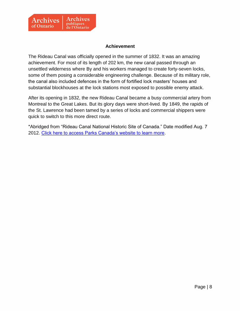
Lower Bytown and Sappers’ Bridge (1845)
Lower Bytown, from the Barrack Hill, near the head of the Eighth Lock and the “Sappers’ Bridge,” 1845
Thomas Burrowes fonds, Reference Code: C 1-0-0-0-11, Archives of Ontario, I0002129

Page | 10
Eastern End of Rideau Canal (1830)
Map of Eastern End of Rideau Canal, 1830
Thomas Burrowes fonds, Reference Code: C 1-0-0-0-115, Archives of Ontario, I0002234

Page | 11
Dam at Jones’ Falls (1841)
Dam at Jones’ Falls; when nearly completed, showing the last temporary passage provided for the surplus water, 1841
Thomas Burrowes fonds, Reference Code: C 1-0-0-0-52, Archives of Ontario, I0002171

Page | 12
Opinicon Lake (1840)
Opinicon Lake looking to the northwest by Thomas Burrowes, 1840
Thomas Burrowes fonds, Reference Code: C 1-0-0-0-47
Archives of Ontario, I0002166

Page | 13
Honourable Thomas McKay’s Mills (1845)
Honourable Thomas McKay's Mills, Distillery, etc. and part of New Edinburgh, Rideau Falls, by Thomas Burrowes, 1845
Thomas Burrowes fonds, Reference Code: C 1-0-0-0-4
Archives of Ontario, I0002121
Page | 14
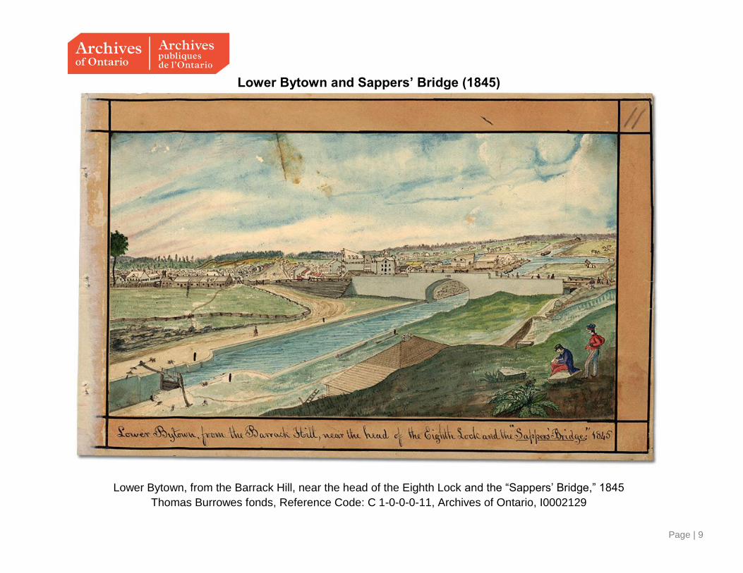
Canoe Heading Towards Bytown
Upper Rideau Lake; Canoe en route to Bytown; Westport in the Distance, by Thomas Burrowes
Watercolour
Thomas Burrowes fonds, Reference Code: C 1-0-0-0-33, Archives of Ontario, I0002152

Page | 15
Rocky cut at the Isthmus to join Rideau Lake
Rocky cut at the Isthmus to join Rideau Lake and the Waters falling into Lake Ontario, looking South, by Thomas
Burrowes, 1841
Thomas Burrowes fonds
Reference Code: C 1-0-0-0-37
Archives of Ontario, I0002156
Page | 16
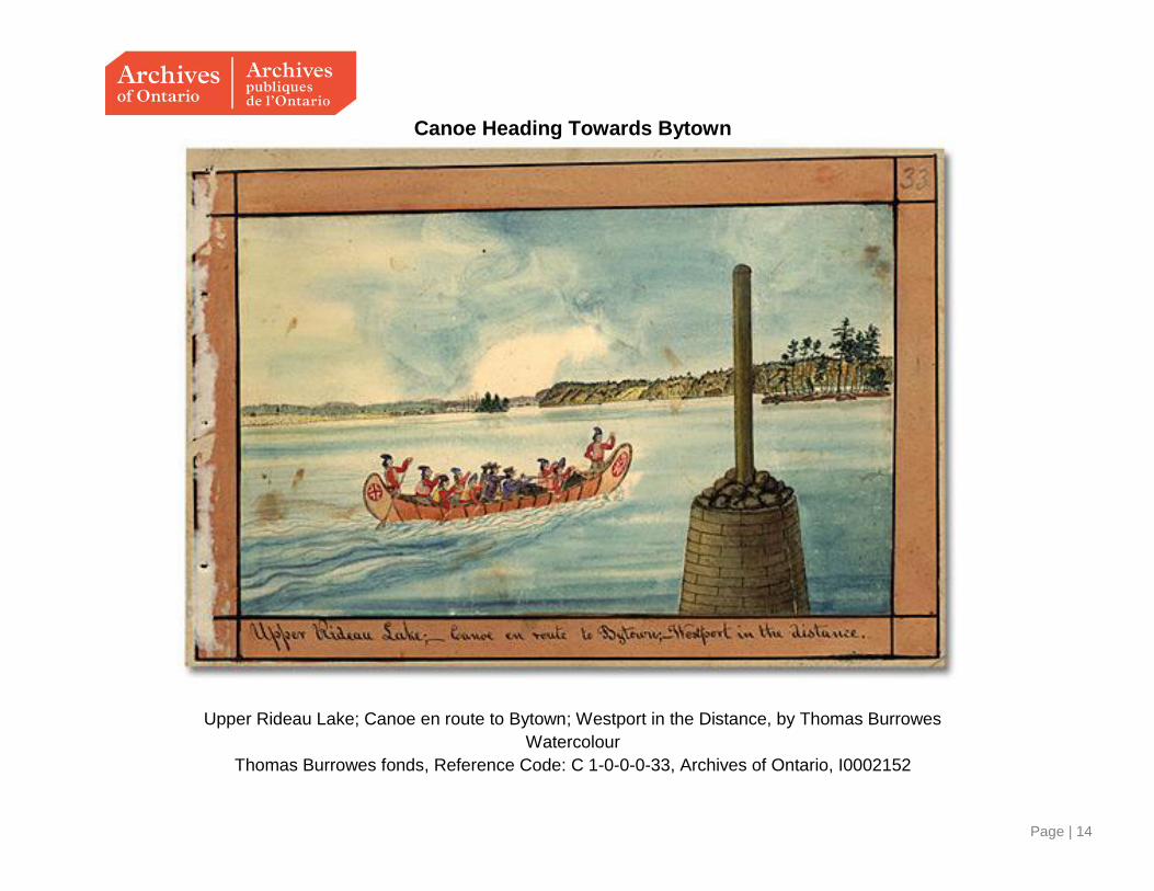
The last ascent to the Summit Water of Canal from Lake Ontario
Locks at the Istmus, the last ascent to the Summit Water of Canal from Lake Ontario, by Thomas Burrowes, 1841
Thomas Burrowes fonds, Reference Code: C 1-0-0-0-36, Archives of Ontario, I0002155

Page | 17
Lock at Chaffey’s Mills
Lock, Waste-weir at Chaffey's Mills, by Thomas Burrowes, 1833
Thomas Burrowes fonds, Reference Code: C 1-0-0-0-44, Archives of Ontario, I0002163
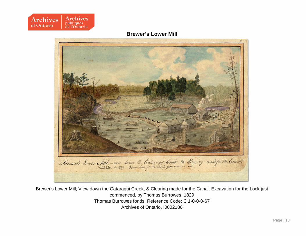
Page | 18
Brewer’s Lower Mill
Brewer's Lower Mill; View down the Cataraqui Creek, & Clearing made for the Canal. Excavation for the Lock just
commenced, by Thomas Burrowes, 1829
Thomas Burrowes fonds, Reference Code: C 1-0-0-0-67
Archives of Ontario, I0002186


![Rideau Reflections - Fall/Winter 2014 · 2015-03-27 · Friends of the Rideau – Rideau Reflections Fall/Winter 2014 Page 2 breadth 83 yards, from its south [north] entrance to the](https://static.fdocuments.us/doc/165x107/5f0c604f7e708231d4351830/rideau-reflections-fallwinter-2015-03-27-friends-of-the-rideau-a-rideau-reflections.jpg)