Legend - 204.101.207.53204.101.207.53/im/Documents/fpm/RV5/Kings/Kings... · Regula tion L m...
1
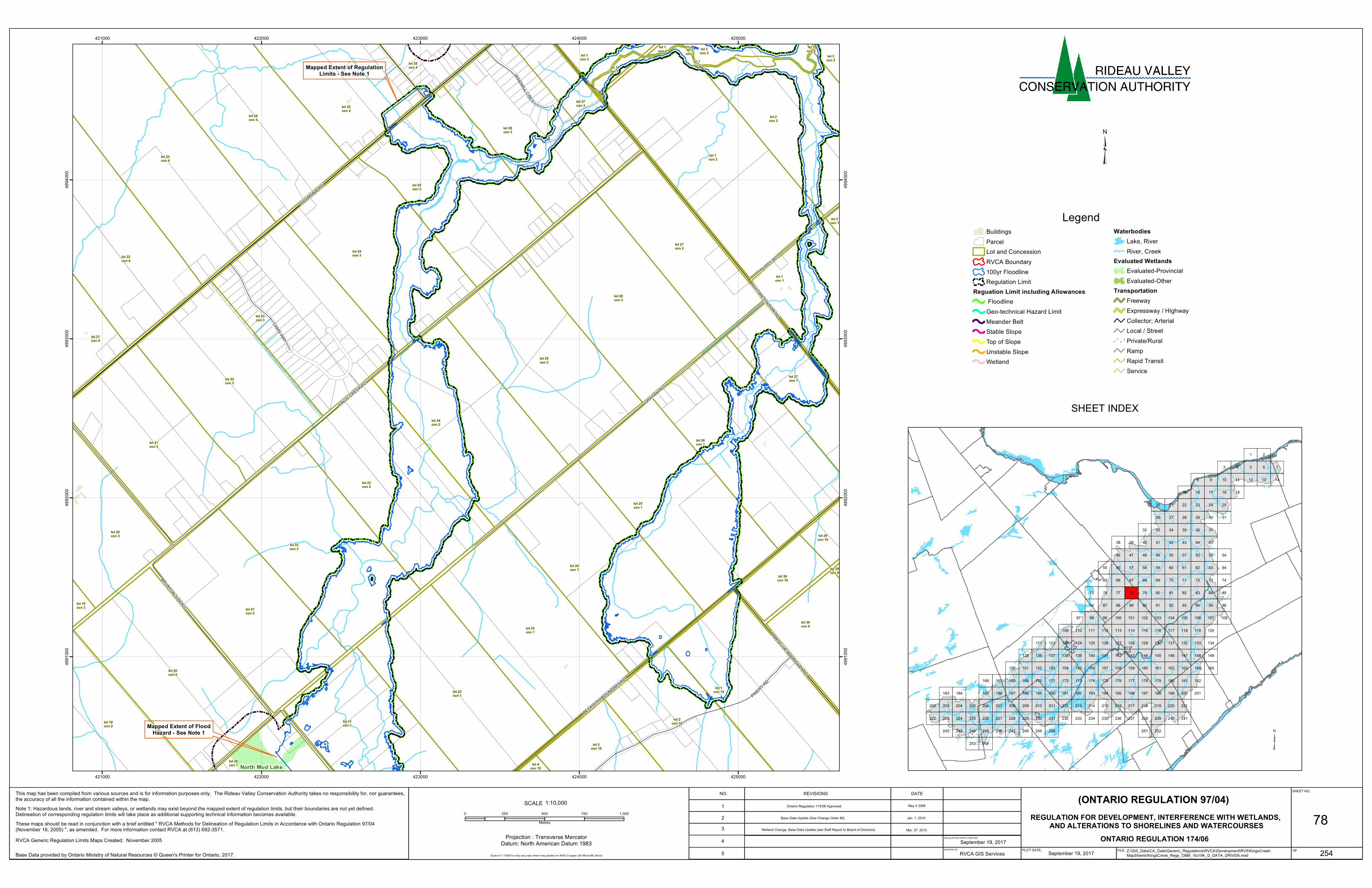
Mapped Extent of Regulation Limits - See Note 1 Mapped Extent of Flood Hazard - See Note 1 North Mud Lake RICHMOND RD KINGS CREEK RD GRAHAM RD BRUNTON SIDERD ASHTON STATION RD PINERY RD BECKWITH BOUNDARY RD PURDY RD CAMS WAY MONTAGUE BOUNDARY RD WINDMILL CRES lot 23 con 4 lot 1 con 2 lot 22 con 2 lot 25 con 1 lot 24 con 1 lot 23 con 1 lot 26 con 1 lot 20 con 2 lot 24 con 2 lot 26 con 2 lot 23 con 2 lot 25 con 2 lot 22 con 1 lot 24 con 3 lot 25 con 3 lot 24 con 4 lot 21 con 2 lot 22 con 3 lot 21 con 3 lot 23 con 3 lot 22 con 4 lot 26 con 3 lot 1 con 10 lot 27 con 2 lot 2 con 2 lot 21 con 1 lot 25 con 4 lot 20 con 3 lot 2 con 10 lot 19 con 2 lot 1 con 1 lot 27 con 1 lot 30 con 9 lot 27 con 3 lot 3 con 10 lot 20 con 1 lot 21 con 4 lot 30 con 10 lot 26 con 4 lot 2 con 2 lot 1 con 3 lot 29 con 10 lot 3 con 2 lot 19 con 3 lot 4 con 10 lot 1 con 3 lot 2 con 1 lot 1 con 2 lot 29 con 9 lot 2 con 2 lot 3 con 2 lot 1 con 2 421000 421000 422000 422000 423000 423000 424000 424000 425000 425000 4991000 4991000 4992000 4992000 4993000 4993000 4994000 4994000 Legend Buildings Parcel Lot and Concession RVCA Boundary 100yr Floodline Regulation Limit Reguation Limit including Allowances Floodline Geo-technical Hazard Limit Meander Belt Stable Slope Top of Slope Unstable Slope Wetland Waterbodies Lake, River River, Creek Evaluated Wetlands Evaluated-Provincial Evaluated-Other Transportation Freeway Expressway / Highway Collector; Arterial Local / Street Private/Rural Ramp Rapid Transit Service SHEET INDEX 78 3 9 6 2 5 1 8 7 4 97 54 37 34 35 32 99 98 36 33 95 13 45 42 92 43 93 38 12 10 96 88 87 40 90 73 53 63 84 17 24 30 27 50 21 60 70 81 22 28 51 82 15 31 64 61 66 65 85 77 76 18 25 48 46 58 56 55 71 68 79 89 86 39 44 94 14 11 41 91 57 67 78 75 47 23 29 52 62 72 83 16 74 20 19 26 49 59 69 80 107 104 203 220 210 207 105 108 100 221 218 212 206 204 102 216 215 213 209 154 155 160 246 242 249 152 162 208 211 219 103 202 205 106 214 217 101 151 251 248 243 163 158 157 245 117 120 134 131 121 146 136 180 170 167 186 183 223 199 189 240 230 227 166 118 115 112 110 109 132 129 124 144 139 138 135 178 172 169 197 191 185 184 241 238 232 229 226 224 254 113 127 126 123 147 142 141 181 176 175 173 200 195 194 192 188 236 235 233 165 159 156 153 150 250 247 164 161 252 244 149 114 111 128 125 196 237 143 140 177 174 193 234 122 137 179 171 168 198 228 225 222 253 119 116 133 130 148 145 182 201 190 187 239 231 ³ Note 1: Hazardous lands, river and stream valleys, or wetlands may exist beyond the mapped extent of regulation limits, but their boundaries are not yet defined. Delineation of corresponding regulation limits will take place as additional supporting technical information becomes available. These maps should be read in conjunction with a brief entitled " RVCA Methods for Delineation of Regulation Limits in Accordance with Ontario Regulation 97/04 (November 16, 2005) ", as amended. For more information contact RVCA at (613) 692-3571. September 19, 2017 Base Data provided by Ontario Ministry of Natural Resources © Queen's Printer for Ontario, 2017. SCALE 0 250 500 750 1,000 Metres Projection : Transverse Mercator Datum: North American Datum 1983 ³ 1:10,000 254 This map has been compiled from various sources and is for information purposes only. The Rideau Valley Conservation Authority takes no responsibility for, nor guarantees, the accuracy of all the information contained within the map. SHEET NO. OF FILE: PLOT DATE: REGULATION LIMITS CREATED MAPPING BY DATE REVISIONS NO. REGULATION FOR DEVELOPMENT, INTERFERENCE WITH WETLANDS, AND ALTERATIONS TO SHORELINES AND WATERCOURSES (ONTARIO REGULATION 97/04) ONTARIO REGULATION 174/06 September 19, 2017 RVCA GIS Services Z:\GIS_Data\CA_Data\Generic_Regulations\RVCA\Development\RV5\KingsCreek\ MapSheets\KingsCreek_Regs_OBM_1to10K_D_DATA_DRIVEN.mxd 1 Scale of 1:10000 is only accurate when map plotted on ANSI D paper (55.88cmx86.36cm) 2 3 5 RVCA Generic Regulation Limits Maps Created: November 2005 4 Ontario Regulation 174/06 Approved Base Data Update (See Change Order #2) Wetland Change, Base Data Update (see Staff Report to Board of Directors) May 4 2006 Jan. 1, 2010 Mar. 27, 2015
Transcript of Legend - 204.101.207.53204.101.207.53/im/Documents/fpm/RV5/Kings/Kings... · Regula tion L m...
Mapped Extent of RegulationLimits - See Note 1
Mapped Extent of FloodHazard - See Note 1
North Mud Lake
RICHMOND RD
KINGS CREEK RD
GRAHAM RD
BRUNTON SIDERD
ASHTON STATION RD
PINERY RD
BECKWITH BOUNDARY RD
PURDY RD
CAMS WAY
MONTAGUE BOUNDARY RD
WINDMILL CRES
lot 23con 4
lot 1con 2
lot 22con 2
lot 25con 1
lot 24con 1
lot 23con 1
lot 26con 1
lot 20con 2
lot 24con 2
lot 26con 2
lot 23con 2
lot 25con 2
lot 22con 1
lot 24con 3
lot 25con 3
lot 24con 4
lot 21con 2
lot 22con 3
lot 21con 3
lot 23con 3
lot 22con 4
lot 26con 3
lot 1con 10
lot 27con 2
lot 2con 2
lot 21con 1
lot 25con 4
lot 20con 3
lot 2con 10lot 19
con 2
lot 1con 1
lot 27con 1
lot 30con 9
lot 27con 3
lot 3con 10
lot 20con 1
lot 21con 4
lot 30con 10
lot 26con 4
lot 2con 2lot 1
con 3
lot 29con 10
lot 3con 2
lot 19con 3
lot 4con 10
lot 1con 3
lot 2con 1
lot 1con 2
lot 29con 9
lot 2con 2
lot 3con 2
lot 1con 2
421000
421000
422000
422000
423000
423000
424000
424000
425000
425000
4991
000
4991
000
4992
000
4992
000
4993
000
4993
000
4994
000
4994
000
LegendBuildingsParcelLot and ConcessionRVCA Boundary100yr FloodlineRegulation Limit
Reguation Limit including Allowances FloodlineGeo-technical Hazard LimitMeander BeltStable SlopeTop of SlopeUnstable SlopeWetland
WaterbodiesLake, RiverRiver, Creek
Evaluated WetlandsEvaluated-ProvincialEvaluated-Other
TransportationFreewayExpressway / HighwayCollector; ArterialLocal / StreetPrivate/RuralRampRapid TransitService
SHEET INDEX
78
3
9
6
2
5
1
8
74
97
54
3734 3532
9998
3633
95
13
4542
92
43
93
38
1210
968887
40
90
73
53
63
84
17
24
3027
50
21
60
70
81
22
28
51
82
15
31
6461
6665
857776
18
25
4846
585655
7168
79
8986
39 44
94
1411
41
91
57
67
7875
47
23
29
52
62
72
83
16
74
20
19
26
49
59
69
80
107104
203 220210207
105 108100
221218212206204
102
216215213209
154 155 160
246242 249
152 162
208 211 219
103
202 205
106
214 217
101
151
251248243
163158157
245
117 120
134131121
146136
180170167
186183
223
199189
240230227
166
118115112110109
132129124
144139138135
178172169
197191185184
241238232229226224
254
113
127126123
147142141
181176175173
200195194192188
236235233
165159156153150
250247
164161
252244
149
114111
128125
196
237
143140
177174
193
234
122
137
179171168
198
228225222
253
119116
133130
148145
182
201190187
239231
³
Note 1: Hazardous lands, river and stream valleys, or wetlands may exist beyond the mapped extent of regulation limits, but their boundaries are not yet defined. Delineation of corresponding regulation limits will take place as additional supporting technical information becomes available.These maps should be read in conjunction with a brief entitled " RVCA Methods for Delineation of Regulation Limits in Accordance with Ontario Regulation 97/04 (November 16, 2005) ", as amended. For more information contact RVCA at (613) 692-3571.
September 19, 2017Base Data provided by Ontario Ministry of Natural Resources © Queen's Printer for Ontario, 2017.
SCALE0 250 500 750 1,000
Metres
Projection : Transverse MercatorDatum: North American Datum 1983
³
1:10,000
254
This map has been compiled from various sources and is for information purposes only. The Rideau Valley Conservation Authority takes no responsibility for, nor guarantees, the accuracy of all the information contained within the map.
SHEET NO.
OFFILE:PLOT DATE:
REGULATION LIMITS CREATED
MAPPING BY
DATEREVISIONSNO.
REGULATION FOR DEVELOPMENT, INTERFERENCE WITH WETLANDS, AND ALTERATIONS TO SHORELINES AND WATERCOURSES
(ONTARIO REGULATION 97/04)
ONTARIO REGULATION 174/06September 19, 2017RVCA GIS Services Z:\GIS_Data\CA_Data\Generic_Regulations\RVCA\Development\RV5\KingsCreek\
MapSheets\KingsCreek_Regs_OBM_1to10K_D_DATA_DRIVEN.mxd
1
Scale of 1:10000 is only accurate when map plotted on ANSI D paper (55.88cmx86.36cm)
23
5
RVCA Generic Regulation Limits Maps Created: November 2005 4
Ontario Regulation 174/06 Approved
Base Data Update (See Change Order #2)
Wetland Change, Base Data Update (see Staff Report to Board of Directors)
May 4 2006
Jan. 1, 2010
Mar. 27, 2015


![OT Survey I Kings. English Location of Kings in Canon Hebrew [Historical Books] Joshua Joshua Judges Judges Ruth Ruth Samuel Samuel Kings Kings Chronicles.](https://static.fdocuments.us/doc/165x107/56649e155503460f94affa26/ot-survey-i-kings-english-location-of-kings-in-canon-hebrew-historical-books.jpg)