Legacy Communities Scheme - Queen Elizabeth …/media/lldc/local plan/local... · elements within...
60
Legacy Communities Scheme Regulation 22 and additional information submission Revised Green Infrastructure Strategy February 2012
Transcript of Legacy Communities Scheme - Queen Elizabeth …/media/lldc/local plan/local... · elements within...
Legacy Communities Scheme Regulation 22 and additional information
submission
Revised Green Infrastructure Strategy
February 2012
Prepared by: Richard Jones ....................................... Checked by: Michael Henderson ........................................
Senior Planner Senior Sustainability Consultant
Approved by: Adam Williams .....................................
Director
Legacy Communities Scheme Regulation 22 and additional information
submission
Revised Green

Telephone: Website:
Job No Reference
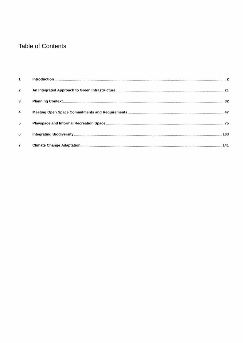
1 Introduction ....................................................................................................................................................................... 2
2 An Integrated Approach to Green Infrastructure ......................................................................................................... 21
3 Planning Context ............................................................................................................................................................. 32
4 Meeting Open Space Commitments and Requirements .............................................................................................. 47
5 Playspace and Informal Recreation Space ................................................................................................................... 75
6 Integrating Biodiversity ................................................................................................................................................ 103
7 Climate Change Adaptation ......................................................................................................................................... 141
Table of Contents

1. Introduction
LCS-GLB-ACC-GIS-002 Revised Green Infrastructure Strategy
Page 2 of 185
1.1 Aims and Purpose of this Strategy
1.1.1 This document sets out the Revised Green Infrastructure Strategy for the Legacy Communities
Scheme (LCS). It has been produced to support the LCS planning application and provides an
overarching vision for the approach towards the development management of all green infrastructure
elements within the planning application area within the context of the surrounding Queen Elizabeth
Olympic Park. The LCS planning application area in the context of the future Queen Elizabeth Olympic
Park is shown in Figure 1.1.
1.1.2 The Revised Green Infrastructure Strategy presents a single approach to open space, play provision,
biodiversity and the natural environment, and climate change adaption reflecting the interconnected
nature of these elements. The production of a single strategy is intended to present clear and succinct
guidance to ensure that open and green spaces are provided that maximise recreational, ecological
and environmental amenity within the LCS.
1.1.3 The Revised Green Infrastructure Strategy also demonstrates how extant Park wide commitments will
be met through the LCS development. This includes the long-term commitment to provide 102 ha of
Metropolitan Open Land and 45 ha of Biodiversity Action Plan (BAP) habitats across the Olympic Site.
1.1.4 It also identifies how strategic planning policies relating to Green Infrastructure can be accommodated
within the scheme relating to open space, playspace, biodiversity and climate change adaptation.
1.2 Rationale
1.2.1 A strategic and co-ordinated approach to Green Infrastructure is advocated in a range of national,
regional and local policies. In particular the Government’s draft Planning Policy Statement Planning for
a Natural and Healthy Environment draws together policy approaches to the natural environment,
green infrastructure, open space, sport, recreation and play.
1.2.2 The Revised Green Infrastructure strategy seeks to set out principles for the quantum and location of
spaces and corridors that form part of the LCS and the future Queen Elizabeth Olympic Park network.
The strategy also considers appropriate open space functions related to the environmental context of
the Park, mandatory standards and commitments, and the needs of new and existing local
communities.
1.3 Legacy Communities Scheme Background
1.3.1 In order to deliver the long term regeneration of the future Queen Elizabeth Olympic Park, the Olympic
Park Legacy Company (‘the Legacy Company’) submitted the LCS Planning Application ("LCS
Planning Application") in September 2011. The LCS Planning Application was submitted to the
Olympic Delivery Authority Planning Decisions Team (ODA PDT) for approval of the built development
and associated infrastructure to deliver the long term legacy of the Queen Elizabeth Olympic Park. The
1 Introduction
LCS-GLB-ACC-GIS-002 Revised Green Infrastructure Strategy
Page 3 of 185
LCS Planning Application was registered under application number 11/90621/OUTODA. A separate
application was submitted to the ODA and the London Borough of Newham for the extension of the
District Heating Network ("District Heating Network Extension Planning Application") across Stratford
High Street to serve proposed development to the south of Stratford High Street. This application was
registered under application number 11/01790/OUT for the LB Newham and 11/90628/OUTODA for the
ODA PDT.
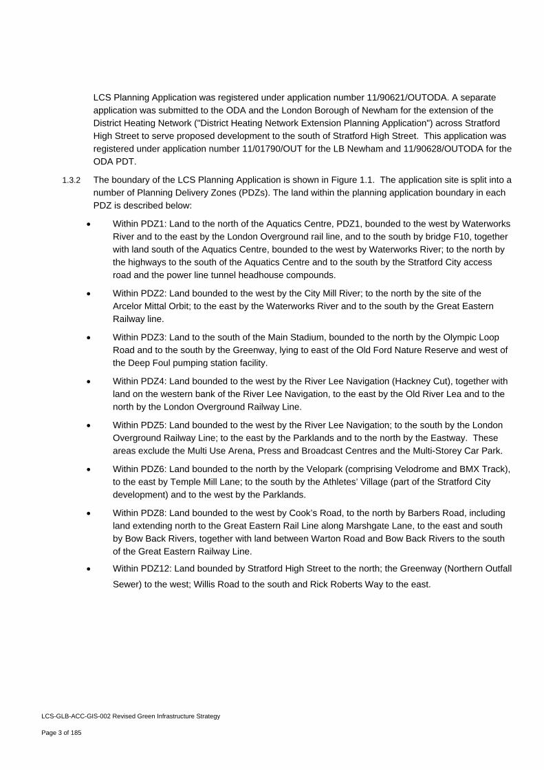
1.3.2 The boundary of the LCS Planning Application is shown in Figure 1.1. The application site is split into a
number of Planning Delivery Zones (PDZs). The land within the planning application boundary in each
PDZ is described below:
Within PDZ1: Land to the north of the Aquatics Centre, PDZ1, bounded to the west by Waterworks
River and to the east by the London Overground rail line, and to the south by bridge F10, together
with land south of the Aquatics Centre, bounded to the west by Waterworks River; to the north by
the highways to the south of the Aquatics Centre and to the south by the Stratford City access
road and the power line tunnel headhouse compounds.
Within PDZ2: Land bounded to the west by the City Mill River; to the north by the site of the
Arcelor Mittal Orbit; to the east by the Waterworks River and to the south by the Great Eastern
Railway line.
Within PDZ3: Land to the south of the Main Stadium, bounded to the north by the Olympic Loop
Road and to the south by the Greenway, lying to east of the Old Ford Nature Reserve and west of
the Deep Foul pumping station facility.
Within PDZ4: Land bounded to the west by the River Lee Navigation (Hackney Cut), together with
land on the western bank of the River Lee Navigation, to the east by the Old River Lea and to the
north by the London Overground Railway Line.
Within PDZ5: Land bounded to the west by the River Lee Navigation; to the south by the London
Overground Railway Line; to the east by the Parklands and to the north by the Eastway. These
areas exclude the Multi Use Arena, Press and Broadcast Centres and the Multi-Storey Car Park.
Within PDZ6: Land bounded to the north by the Velopark (comprising Velodrome and BMX Track),
to the east by Temple Mill Lane; to the south by the Athletes’ Village (part of the Stratford City
development) and to the west by the Parklands.
Within PDZ8: Land bounded to the west by Cook’s Road, to the north by Barbers Road, including
land extending north to the Great Eastern Rail Line along Marshgate Lane, to the east and south
by Bow Back Rivers, together with land between Warton Road and Bow Back Rivers to the south
of the Great Eastern Railway Line.
Within PDZ12: Land bounded by Stratford High Street to the north; the Greenway (Northern Outfall
Sewer) to the west; Willis Road to the south and Rick Roberts Way to the east.
LCS-GLB-ACC-GIS-002 Revised Green Infrastructure Strategy
Page 4 of 185
Figure 1.1 LCS Planning Application Boundary
1.4 District Heat Network Extension Planning Application
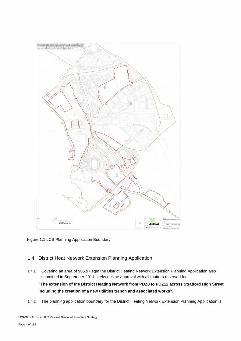
1.4.1 Covering an area of 965.97 sqm the District Heating Network Extension Planning Application also
submitted in September 2011 seeks outline approval with all matters reserved for:
“The extension of the District Heating Network from PDZ8 to PDZ12 across Stratford High Street
including the creation of a new utilities trench and associated works”.
1.4.2 The planning application boundary for the District Heating Network Extension Planning Application is
LCS-GLB-ACC-GIS-002 Revised Green Infrastructure Strategy
Page 5 of 185
shown in Figure 1.2 below.
Figure 1.2 District Heat Network Extension Planning Application Boundary
1.5 Regulation 22 Response and Additional Information Submission (February 2012)
1.5.1 During October and November 2011 the Olympic Delivery Authority Planning Decisions team
considered the LCS Planning Application and District Heat Network Extension Planning Application,
and consulted on the planning applications. Subsequently, on 30th November 2011, the ODA PDT
issued a request under Regulation 22 of the Town and Country Planning (Environmental Impact
Assessment) Regulations 2011 in relation to the LCS Planning Application for the submission of further
environmental information. On 5th December 2011 the ODA PDT issued a letter commenting on the
LCS Planning Application and identifying matters where the planning authority considered that the
planning application and its supporting information required amendment, clarification, correction or
additional information.
1.5.2 In response to these requests, the Olympic Park Legacy Company has prepared this submission of
Regulation 22 Response and Additional Information, which is submitted to the ODA PDT in February
LCS-GLB-ACC-GIS-002 Revised Green Infrastructure Strategy
Page 6 of 185
2012. The submission comprises the following material in relation to the LCS Planning Application:
1.5.2.1 Information submitted in response to the Regulation 22 request; and
1.5.2.2 Information submitted in response to the amendment, clarification, correction or additional information
requested by ODA PDT, which include some amendments and refinements to the Legacy Communities
Scheme which is the subject of the LCS Planning Application.
1.6 Amendments to the Legacy Communities Scheme
1.6.1 Since the LCS Planning Application was submitted in September 2011, the Legacy Company has
amended and refined development proposals in discussion with stakeholders, and in response to
issues raised through the consultation on the planning application. These scheme amendments and
refinements are described in detail in the Revised Development Specification & Framework [LCS-GLB-
APP-DSF-002], and in summary are as follows.
Planning Delivery Zone 1
‐ In the eastern part of Development Parcel 1.2, the previously proposed 10,000 sqm of student
accommodation (Use Class C2) has been replaced with residential development (Use Class C3).
Planning Delivery Zone 2
‐ Reconfiguration of children's play facilities to locate doorstep play spaces within the residential
areas, with neighbourhood play space associated with more public areas close to the Arcelor
Mittal Orbit.
Planning Delivery Zone 4
‐ Revised proposals for Development Parcel 4.6, now include the provision of playing fields for the
primary school located in Development Parcel 4.7 immediately to the south. The playing fields
will be bordered by residential development along the northern and eastern edge of the parcel.
‐ The design intent for the canal edge in PDZ4 has been amended to include a significant
proportion of green corridor, including semi-natural habitat, together with civic spaces, including
a significant civic space directly south of White Post Lane Bridge.
Planning Delivery Zone 6
‐ Amendment of land use parameter plan to include definition of a limited number of frontages
where up to 70% residential use is appropriate, rather than 90% as defined on the majority of
frontages.
Planning Delivery Zone 5
‐ Residential and retail development is removed from Development Parcel 5.10, so that Primary
School (Use Class D1) will occupy the whole of the Development Parcel.
LCS-GLB-ACC-GIS-002 Revised Green Infrastructure Strategy
Page 7 of 185
‐ Development Parcel 5.10 is increased in size to 5,650 sq m to provide a larger site for the
Primary School.
‐ The nursery provision within Development Parcel 5.5 is relocated to be immediately adjacent to
the Primary School in Development Parcel 5.10.
Planning Delivery Zone 8
‐ Within the total of 118,290 sqm of residential floorspace within this PDZ, the proposals now
include up to 4,000 sqm of Sheltered Accommodation (providing up to 40 units (Use Class C3))
within Development Parcel 8.1.
Planning Delivery Zones 1, 4, 5 and 8
‐ Amendment to maximum and minimum building height parameters, particularly on important
frontages, to clarify the range of acceptable building heights in these locations.
The red line application boundary for the LCS Planning Application remains unchanged.
1.7 Regulation 22 and Additional Information Submission (February 2012) (the "February 2012 Submission")
1.7.1 Revised versions of the following documents are being submitted for approval as part of the February
2012 Submission, in replacement for the versions of these documents originally submitted:
‐ Development Specification Framework
‐ Parameter Plans (site wide and PDZ specific) including the Phasing Plan for Approval
‐ Design Codes (site wide and PDZ specific)
1.7.2 The following revised documents are being submitted in support of the LCS Planning Application as
part of the February 2012 Submission, in replacement for the versions of these documents originally
submitted:
‐ Revised Design and Access Statement
‐ Revised Green Infrastructure Strategy
‐ Revised Global Remediation Strategy
‐ Revised Energy Statement
‐ Revised Health Impact Statement
‐ Revised Environmental Statement Non-Technical Summary
‐ Sustainability Statement
LCS-GLB-ACC-GIS-002 Revised Green Infrastructure Strategy
Page 8 of 185
1.7.3 Addendums to the following documents are being submitted as part of the February 2012 Submission,
by way of addendum to the documents originally submitted:
‐ Flood Risk Assessment
‐ Code of Construction Practice
‐ Housing and Social Infrastructure Statement
‐ Retail and Leisure Impact Assessment
‐ Employment Statement
‐ Estate Management Strategy
‐ Utilities Statement
‐ Transport Assessment
‐ Environmental Statement
‐ Interim Uses Statement
1.7.4 The following new document is being submitted as part of the February 2012 Submission in support of
the LCS Planning Application:
‐ Vision and Convergence Statement, which sets out the overall vision for the Queen Elizabeth
Olympic Park in its wider regional to local context and how the Legacy Communities Scheme
responds to this. It also sets out how the Legacy Communities Scheme contributes to the Host
Borough and Mayoral objective of Convergence.
1.7.5 No amendments are being made to the following documents as part of the February 2012 Submission:
‐ Planning Statement
‐ Statement of Participation
‐ Equalities Impact Statement
1.8 Development Phasing
1.8.1 The February 2012 Submission clarifies the approach to development phasing. For the purposes of
the Environmental Impact Assessment process, which is reported In the Environmental Statement and
its Addendum (LCS-GLB-ACC-ES-001 and 001A) which accompanies both planning applications, the
LCS development is anticipated to be delivered over 18 years covering the period from 2013 to 2031.
Phase 1: covers a period from 2013 to 2014 and includes site preparation and construction works in
relation to development within Planning Delivery Zone 6 (but does not include occupation of new
homes, which will occur from 2015 onwards). Phase One covers the construction of open space and
key areas of public realm in PDZ6, the school playing fields in PDZ5 and the play space within the
LCS-GLB-ACC-GIS-002 Revised Green Infrastructure Strategy
Page 9 of 185
concourse area in PDZ2. Phase One also covers the construction of tertiary roads within PDZ6.
Phase 2: is anticipated to be first occupied from 2015 to 2021 and is expected to deliver up to 307,561
sqm of floorspace; and
Phase 3: is anticipated to be first occupied from 2022 to 2031 and is expected to deliver up to 454,697
sqm of floorspace.
1.8.2 These development phases are shown on the Development Phasing Plan [LCS-DWG-APP-PHS-PAR-
GLB-001], which is now submitted for approval.
1.9 Revised Description of Development
1.9.1 The following revised description of development reflects the amendments to the Legacy Communities
Scheme, as summarised above. The full revised description of development is set out in the Revised
Development Specification & Framework (LCS-GLB-APP-DSF-002).
1.9.2 Covering an area of 64.48 hectares in discrete areas lying within the future Queen Elizabeth Olympic
Park, the LCS Planning Application seeks outline approval, with all matters reserved, for development
comprising1:
“Comprehensive, phased, mixed use development within the future Queen Elizabeth Olympic
Park, as set out in the Revised Development Specification & Framework (LCS-GLB-APP-DSF-
002). The development comprises up to 641,817 sqm of residential (C3) uses; including up to
4,000 sqm of Sheltered (C3) Accommodation; up to 14,500 sqm of hotel (C1) accommodation; up
to 30,369 sqm (B1a) and up to 15,770 sqm (B1b/B1c) business and employment uses; up to
25,987 sqm (A1-A5) shopping, food and drink and financial and professional services; up to 3,606
sqm (D2) leisure space and up to 30,209 sqm (D1) community, health, cultural, assembly and
education facilities, including two primary schools and one secondary school; new streets and
other means of access and circulation, construction of open and covered car parking;
landscaping including laying out of open space with provision for natural habitats and play
space; new and replacement bridge crossings, re-profiling of site levels, demolition and breaking
out of roads and hardstanding, utilities diversions and connections; and other supporting
infrastructure works and facilities”.
1.9.3 The LCS Planning Application seeks approval for up to 641,817 sqm of residential floorspace, which will
provide up to 6,870 homes, with a scheme wide target of 35% affordable (60:40 social
rented:intermediate split), subject to viability and an indicative target of 42% family accommodation (3
and 3+ bedroom dwellings). A full description of development is set out in the Revised Development
Specification & Framework (LCS-GLB-APP-DSF-002), which forms part of the planning application
material for approval.
1.10 Amendments and clarifications within the Revised Green Infrastructure Strategy
1.10.1 A number of revisions, amendments and clarifications have been made to the Green Infrastructure
1 All floorspace figures quoted are Gross External Area
LCS-GLB-ACC-GIS-002 Revised Green Infrastructure Strategy
Page 10 of 185
Strategy submitted in September 2011 in light of questions and recommendations from consultation with
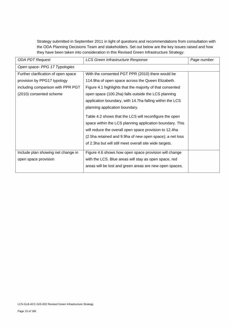
the ODA Planning Decisions Team and stakeholders. Set out below are the key issues raised and how
they have been taken into consideration in this Revised Green Infrastructure Strategy:
ODA PDT Request LCS Green Infrastructure Response Page number
Open space- PPG 17 Typologies
Further clarification of open space
provision by PPG17 typology
including comparison with PPR PGT
(2010) consented scheme
With the consented PGT PPR (2010) there would be
114.9ha of open space across the Queen Elizabeth.
Figure 4.1 highlights that the majority of that consented
open space (100.2ha) falls outside the LCS planning
application boundary, with 14.7ha falling within the LCS
planning application boundary.
Table 4.2 shows that the LCS will reconfigure the open
space within the LCS planning application boundary. This
will reduce the overall open space provision to 12.4ha
(2.5ha retained and 9.9ha of new open space); a net loss
of 2.3ha but will still meet overall site wide targets.
Include plan showing net change in
open space provision
Figure 4.6 shows how open space provision will change
with the LCS. Blue areas will stay as open space, red
areas will be lost and green areas are new open spaces.
LCS-GLB-ACC-GIS-002 Revised Green Infrastructure Strategy
Page 11 of 185
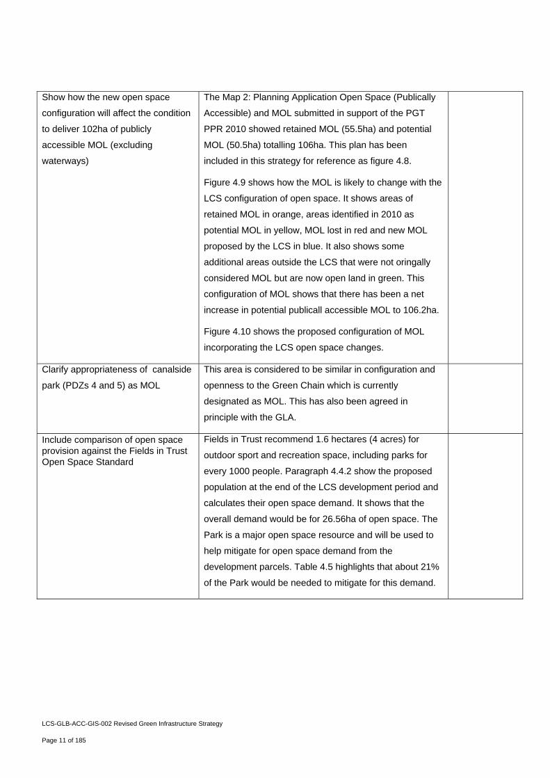
Show how the new open space
configuration will affect the condition
to deliver 102ha of publicly
accessible MOL (excluding
waterways)
The Map 2: Planning Application Open Space (Publically
Accessible) and MOL submitted in support of the PGT
PPR 2010 showed retained MOL (55.5ha) and potential
MOL (50.5ha) totalling 106ha. This plan has been
included in this strategy for reference as figure 4.8.
Figure 4.9 shows how the MOL is likely to change with the
LCS configuration of open space. It shows areas of
retained MOL in orange, areas identified in 2010 as
potential MOL in yellow, MOL lost in red and new MOL
proposed by the LCS in blue. It also shows some
additional areas outside the LCS that were not oringally
considered MOL but are now open land in green. This
configuration of MOL shows that there has been a net
increase in potential publicall accessible MOL to 106.2ha.
Figure 4.10 shows the proposed configuration of MOL
incorporating the LCS open space changes.
Clarify appropriateness of canalside
park (PDZs 4 and 5) as MOL
This area is considered to be similar in configuration and
openness to the Green Chain which is currently
designated as MOL. This has also been agreed in
principle with the GLA.
Include comparison of open space provision against the Fields in Trust Open Space Standard
Fields in Trust recommend 1.6 hectares (4 acres) for
outdoor sport and recreation space, including parks for
every 1000 people. Paragraph 4.4.2 show the proposed
population at the end of the LCS development period and
calculates their open space demand. It shows that the
overall demand would be for 26.56ha of open space. The
Park is a major open space resource and will be used to
help mitigate for open space demand from the
development parcels. Table 4.5 highlights that about 21%
of the Park would be needed to mitigate for this demand.
LCS-GLB-ACC-GIS-002 Revised Green Infrastructure Strategy
Page 12 of 185
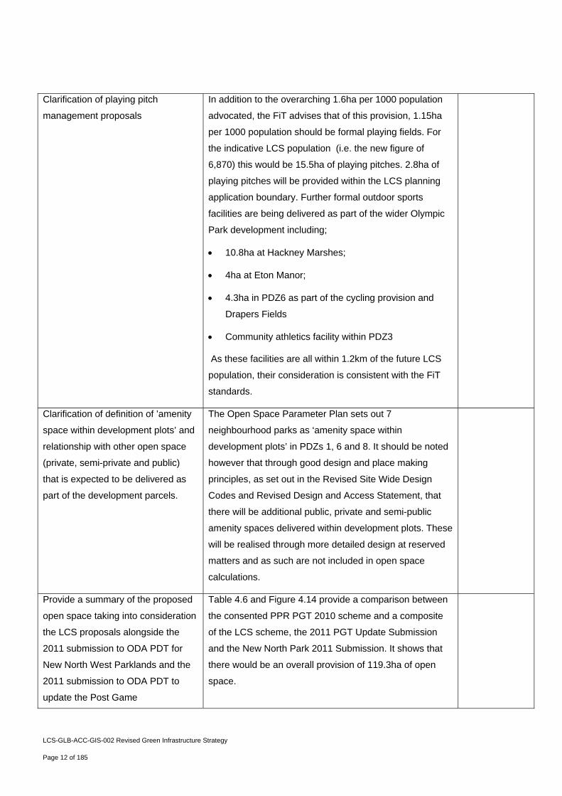
Clarification of playing pitch
management proposals
In addition to the overarching 1.6ha per 1000 population
advocated, the FiT advises that of this provision, 1.15ha
per 1000 population should be formal playing fields. For
the indicative LCS population (i.e. the new figure of
6,870) this would be 15.5ha of playing pitches. 2.8ha of
playing pitches will be provided within the LCS planning
application boundary. Further formal outdoor sports
facilities are being delivered as part of the wider Olympic
Park development including;
10.8ha at Hackney Marshes;
4ha at Eton Manor;
4.3ha in PDZ6 as part of the cycling provision and
Drapers Fields
Community athletics facility within PDZ3
As these facilities are all within 1.2km of the future LCS
population, their consideration is consistent with the FiT
standards.
Clarification of definition of ’amenity
space within development plots’ and
relationship with other open space
(private, semi-private and public)
that is expected to be delivered as
part of the development parcels.
The Open Space Parameter Plan sets out 7
neighbourhood parks as ‘amenity space within
development plots’ in PDZs 1, 6 and 8. It should be noted
however that through good design and place making
principles, as set out in the Revised Site Wide Design
Codes and Revised Design and Access Statement, that
there will be additional public, private and semi-public
amenity spaces delivered within development plots. These
will be realised through more detailed design at reserved
matters and as such are not included in open space
calculations.
Provide a summary of the proposed
open space taking into consideration
the LCS proposals alongside the
2011 submission to ODA PDT for
New North West Parklands and the
2011 submission to ODA PDT to
update the Post Game
Table 4.6 and Figure 4.14 provide a comparison between
the consented PPR PGT 2010 scheme and a composite
of the LCS scheme, the 2011 PGT Update Submission
and the New North Park 2011 Submission. It shows that
there would be an overall provision of 119.3ha of open
space.
LCS-GLB-ACC-GIS-002 Revised Green Infrastructure Strategy
Page 13 of 185
Transformation.
Clarification of relationship between
Table 4.1 and Figure 4.7
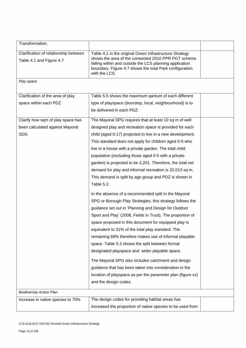
Table 4.1 in the original Green Infrastructure Strategy shows the area of the consented 2010 PPR PGT scheme falling within and outside the LCS planning application boundary. Figure 4.7 shows the total Park configuration with the LCS.
Play space
Clarification of the area of play
space within each PDZ
Table 5.5 shows the maximum qantum of each different
type of playspace (doorstep, local, neighbourhood) is to
be delivered in each PDZ.
Clarify how sqm of play space has
been calculated against Mayoral
SDG
The Mayoral SPG requires that at least 10 sq m of well
designed play and recreation space is provided for each
child (aged 0-17) projected to live in a new development.
This standard does not apply for children aged 0-5 who
live in a house with a private garden. The total child
population (excluding those aged 0-5 with a private
garden) is projected to be 3,201. Therefore, the total net
demand for play and informal recreation is 32,013 sq m.
This demand is split by age group and PDZ is shown in
Table 5.2.
In the absence of a recommended split in the Mayoral
SPG or Borough Play Strategies, this strategy follows the
guidance set out in ‘Planning and Design for Outdoor
Sport and Play’ (2008, Fields in Trust). The proportion of
space proposed in this document for equipped play is
equivalent to 31% of the total play standard. The
remaining 69% therefore makes use of informal playable
space. Table 5.3 shows the split between formal
designated playspace and wider playable space.
The Mayoral SPG also includes catchment and design
guidance that has been taken into consideration in the
location of playspace as per the parameter plan (figure xx)
and the design codes.
Biodiversity Action Plan
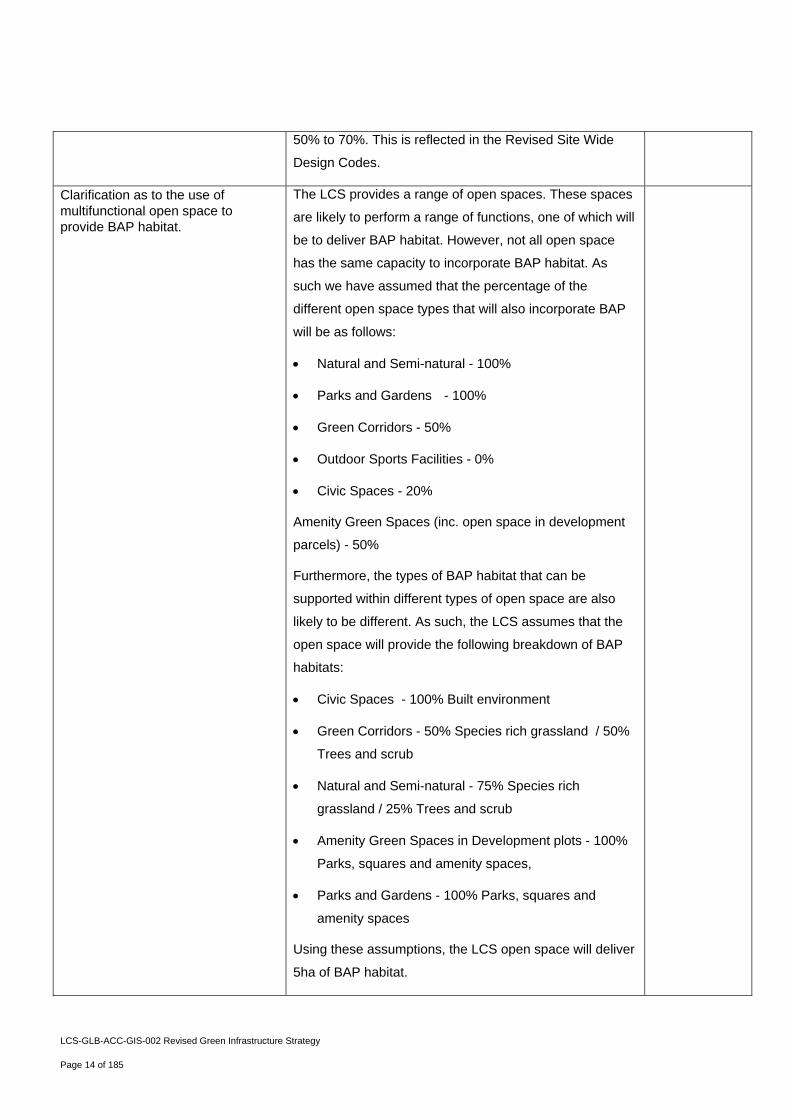
Increase in native species to 70% The design codes for providing habitat areas has
increased the proportion of native species to be used from
LCS-GLB-ACC-GIS-002 Revised Green Infrastructure Strategy
Page 14 of 185
50% to 70%. This is reflected in the Revised Site Wide
Design Codes.
Clarification as to the use of multifunctional open space to provide BAP habitat.
The LCS provides a range of open spaces. These spaces
are likely to perform a range of functions, one of which will
be to deliver BAP habitat. However, not all open space
has the same capacity to incorporate BAP habitat. As
such we have assumed that the percentage of the
different open space types that will also incorporate BAP
will be as follows:
Natural and Semi-natural - 100%
Parks and Gardens - 100%
Green Corridors - 50%
Outdoor Sports Facilities - 0%
Civic Spaces - 20%
Amenity Green Spaces (inc. open space in development
parcels) - 50%
Furthermore, the types of BAP habitat that can be
supported within different types of open space are also
likely to be different. As such, the LCS assumes that the
open space will provide the following breakdown of BAP
habitats:
Civic Spaces - 100% Built environment
Green Corridors - 50% Species rich grassland / 50%
Trees and scrub
Natural and Semi-natural - 75% Species rich
grassland / 25% Trees and scrub
Amenity Green Spaces in Development plots - 100%
Parks, squares and amenity spaces,
Parks and Gardens - 100% Parks, squares and
amenity spaces
Using these assumptions, the LCS open space will deliver
5ha of BAP habitat.

LCS-GLB-ACC-GIS-002 Revised Green Infrastructure Strategy
Page 15 of 185
Define area of green roofs that can support BAP habitat and management requirements
The LCS will deliver a maximum of 3.55ha of intensive
green roofs capable of supporting BAP habitats. These
roofs could support a range of habitats, but for the
purposes of this assessment it has been assumed that
50% will fall under the species rich grassland category of
the BAP and 50% will fall under the built environment
category. Not all roofs are suitable for greening. As such,
a high level assessment against the indicative masterplan
has been undertaken as to where green roofs might be
located subject to detailed design and reserve matters:
PDZ1 - 0.50ha
PDZ2 - 0.43
PDZ4 - 0.53
PDZ5 - 0.67
PDZ6 - 0.28
PDZ8 - 0.78
PDZ12 - 0.36
TOTAL - 3.55
Note that this is an illustrative example only and the final quantum per PDZ will depend on the detailed design of each PDZ.
LCS-GLB-ACC-GIS-002 Revised Green Infrastructure Strategy
Page 16 of 185
Include green roof management
principles
Green roof design codes have been included in this
strategy and as part of the LCS BAP ‘Built Environment’
habitat type.
Clarification open space / BAP
assumptions made in respect to the
landscape on PDZ3 Stadium Island
It has been assumed that the BAP habitat on PDZ3 will be
delivered as show in the baseline position taken from the
2010 PPR PGT.
Comparison with PPR PGT (2010)
and proposed end state legacy
configuration taking into
consideration the Velo application
and PGT (2011) update currently
submitted with ODA PDT for
determination. Including details on
the type and quantum of BAP
habitats suitable for inclusion within
each open space typology
Table 6.2 and figures 6.4 and 6.5 show that the majority of
2010 PPR PGT BAP habitat (39.9ha) falls outside the
LCS planning application boundary and is considered to
be delivered as planned (if 2011 PGT Update is not
granted). This leaves 8.1ha of BAP within the LCS
planning application boundary.
Table 6.9 compares LCS BAP with the PPR PGT 2010
showing that the Park with the LCS open space
configuration will deliver an increase in BAP habitats from
48 ha to 49.1ha
Table 6.10 and figure 6.11 show combined proposals for
BAP taking into consideration the LCS proposals with the
2011 New North Park and the 2011 PGT Update
submissions. This proposed ‘end state’ is compared with
the 2010 PPR PGT showing an increase in BAP provision
from 48 ha to 52.9ha.
Clarification of the role of the LCS
BAP
Appendix 3 includes the LCS BAP. This provides a
greater level of detail than the Olympic Park BAP habitats
for the habitats that form part of the LCS proposals. As
such, it should be viewed as an addendum to the Olympic
Park BAP.
LCS-GLB-ACC-GIS-002 Revised Green Infrastructure Strategy
Page 17 of 185
1.10.2 Reflecting the responses to the comments outlined above, the following changes have been made to the
submitted Green Infrastructure Strategy in this revised version:
Table 1 Summary of Changes to Original Sustainability Statement
Section Paragraph
Reference
Page Amendment Reason for Change
4 Table 4.1 and
Figures 4.3 and 4.4
51-53 Refined analysis of consented
open space falling inside and
outside the LCS planning
application boundary
To provide clarity on the open space
baseline
4 4.2.6 54 Refined analysis of existing v
proposed open space
To provide clarity on the open space
baseline
4 Table 4.2, Figure
4.5, Figure 4.6
55-57 Refined analysis of existing v
proposed open space
To provide clarity on the open space
baseline
4 Table 4.3, Figure 4.7 58-59 LCS open space provision To provide clarity on the open space
baseline
4 4.2.10, Figure 4.8,
Figure 4.9, Figure
4.10
60-63 Explanation of MOL provision
and distribution
In response to ODA PDT request
4 4.4 68-69 Analysis of open space
provision against Fields in
Trust Standard
In response to ODA PDT request
4 4.5 69 Analysis of allotment provision In response to ODA PDT request
4 4.7 70 Clarification of additional open
space to be provided as
amenity space
In response to ODA PDT request
4 Figure 4.13 71 Updated parameter plan Update
4 4.8 72-73 Analysis of open space
provision with New North Park
and PGT 2011 planning
applications
In response to ODA PDT request
5 Figure 5.1 77 Updated plan Update
5 Table 5.2 79 Revised play space demand Responding to changes in the indicative
population from masterplan reconfiguration
LCS-GLB-ACC-GIS-002 Revised Green Infrastructure Strategy
Page 18 of 185
5 Table 5.3 80 Breakdown of formal/informal
playspace
In response to ODA PDT request
5 Table 5.5 87-89 Updated playspace provision
standard
Responding to changes in the indicative
population from masterplan reconfiguration
5 Figure 5.3 90 Updated plan Update
6 6.4.3, Table 6.2,
Figure 6.4 and
Figure 6.5
108-111 Refined analysis of consented
BAP inside and outside of the
LCS planning application
boundary
In response to ODA PDT request
6 6.6.1 113 Increase in native species
provision to 70%
In response to ODA PDT request
6 Table 6.4 115 Analysis of the BAP provision
of different multifunctional open
space typologies
In response to ODA PDT request
6 Table 6.5, Figure 6.6 116-117 Contribution of open space
BAP to meeting 45ha target
Responding to increase in provision
6 Table 6.6, Figure 6.7 120-121 Updated table Previous error
6 6.9.4 126 Clarifying position of green
roofs
In response to ODA PDT request
6 6.9.7 127 Clarifying BAP habitat green
roofs will contribute to
In response to ODA PDT request
6 Table 6.8 131 Updated table Responding to increase in provision
6 Table 6.9 133 Comparison of BAP provision
against PGT 2010 and target
Responding to increase in provision
6 6.11-6.11.3, Table
6.10, Figure 6.11
134-137 Comparison with New North
Park and PGT 2011 planning
applications
In response to ODA PDT request
Appendix
1
Open Space and
BAP numbers
146-153 Revised numbers Clarification
Appendix
2
Green Roofs 162 Additional green roof
management guidelines
In response to ODA PDT request
LCS-GLB-ACC-GIS-002 Revised Green Infrastructure Strategy
Page 19 of 185
2. An Integrated Approach to Green Infrastructure

Olympic Park Legacy Company – Legacy Communities Scheme
LCS-GLB-ACC-GIS-002 Revised Green Infrastructure Strategy
Page 21 of 185
2.1 What is Green Infrastructure?
2.1.1 The London Plan defines green infrastructure as:
“The open environment within urban areas, the urban fringe and the countryside. It is a network of
connected, high quality, multi-functional open spaces, corridors and the links in between that provide
multiple benefits for people and wildlife”.
2.1.2 The improvement to quality of life, which urban communities can gain from access to high quality outdoor
environments has been recognised since the Victorian era. It has evolved through the aspirations of the
Garden City movement to modern provision standards such as Natural England’s Accessible Natural
Greenspace Standard (ANGSt) and Sport England’s sport facility calculator.
2.1.3 In recent years the provision of space for the conservation and restoration of biodiversity has become
increasingly urgent and there now exists an extensive body of international, national and local legislation,
policy and guidance to support this.
2.1.4 Emerging from these open space and ecological considerations has been a more holistic understanding
of the broader environmental functions that these spaces provide. With increasing appreciation that the
built environment and engineering infrastructure can have detrimental impacts on the environment, the
importance of Green Infrastructure as a way to mitigate environmental, social and economic challenges
is becoming understood, in particular, the potential cost and disruption caused by climate change.
2.1.5 The threat of climate change impacts and the need to move towards a low carbon economy furthers the
case for natural systems to provide the flood storage, clean air and water, and comfortable microclimates
that city dwellers need.
2.1.6 Green infrastructure is not confined to formal public green spaces such as parks and gardens, but
ranges from regional landscapes, to local green space, to green roofs. The different types of green
infrastructure covered by this strategy include:
parks and gardens – including urban parks, country parks and formal gardens;
natural and semi-natural urban green spaces – including woodlands, scrub, grasslands,, wetlands,
open and running water;
green corridors – including river and canal banks, verges, cycleways, and rights of way;
outdoor sports facilities (with natural or artificial surfaces and either publicly or privately owned) –
including tennis courts, sports pitches, athletics tracks, school and other institutional playing fields,
and other outdoor sports areas;
amenity greenspace (most commonly, but not exclusively, in housing areas) – including informal
recreation spaces, green spaces in and around housing, domestic gardens and greens;
2 An Integrated Approach to Green Infrastructure
Olympic Park Legacy Company – Legacy Communities Scheme
LCS-GLB-ACC-GIS-002 Revised Green Infrastructure Strategy
Page 22 of 185
provision for children and teenagers – including play areas, adventure playgrounds, skateboard
parks, outdoor basketball hoops, and other more informal areas (e.g. ‘hanging out’ areas, teenage
shelters);
allotments, community gardens, and land used for permaculture;
civic spaces, including civic squares, and other hard-surfaced areas designed for pedestrians; and
building integrated vegetation, including roof gardens, extensive green roofs and living walls.
2.1.7 Green Infrastructure contains public and private open space. The London Plan defines these elements
as follows:
Public Open Space - is defined as public parks, commons, heaths and woodlands and other open
spaces with established and unrestricted public access and capable of being classified according to
the open space hierarchy which meets recreational and non-recreational needs; and
Private Open Space - is defined as open space to which public access is restrict or not formally
established, but which contributes to local amenity or wildlife habitat or meets or is capable of
meeting recreational or non-recreational needs, including school and private playing fields. Private
residential gardens are not included for the purposes of producing a green infrastructure strategy.
Olympic Park Legacy Company – Legacy Communities Scheme
LCS-GLB-ACC-GIS-002 Revised Green Infrastructure Strategy
Page 23 of 185
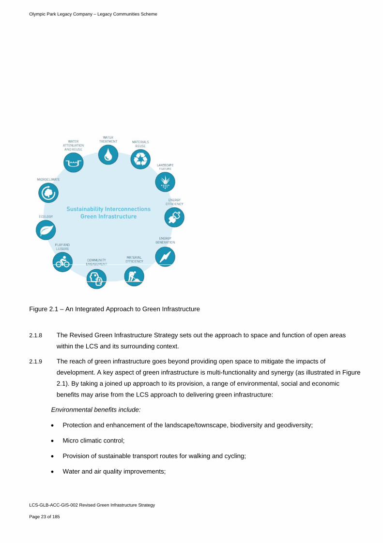
Figure 2.1 – An Integrated Approach to Green Infrastructure
2.1.8 The Revised Green Infrastructure Strategy sets out the approach to space and function of open areas
within the LCS and its surrounding context.
2.1.9 The reach of green infrastructure goes beyond providing open space to mitigate the impacts of
development. A key aspect of green infrastructure is multi-functionality and synergy (as illustrated in Figure
2.1). By taking a joined up approach to its provision, a range of environmental, social and economic
benefits may arise from the LCS approach to delivering green infrastructure:
Environmental benefits include:
Protection and enhancement of the landscape/townscape, biodiversity and geodiversity;
Micro climatic control;
Provision of sustainable transport routes for walking and cycling;
Water and air quality improvements;
Olympic Park Legacy Company – Legacy Communities Scheme
LCS-GLB-ACC-GIS-002 Revised Green Infrastructure Strategy
Page 24 of 185
Carbon capture and storage (sequestration);
Efficient use of land;
Surface water management to reduce flood risk;
Noise pollution abatement; and
Food and pollination.
Economic benefits include:
Provides an inspiring setting for economic growth and investment;
Increases quality of place and labour productivity;
Increases property and land values;
Sustains environmental tourism providing employment opportunities and boosting local economies; and
Helps attract and retain people ensuring stable populations and labour supply.
Social benefits include:
Provides opportunities to improve health and well-being;
Provides recreation and leisure opportunities;
Provides learning and education opportunities, including lifelong learning for adults; and
Facilitates community cohesion by providing opportunities to reinforce feelings of local belonging and
sense of ownership.
Olympic Park Legacy Company – Legacy Communities Scheme
LCS-GLB-ACC-GIS-002 Revised Green Infrastructure Strategy
Page 25 of 185
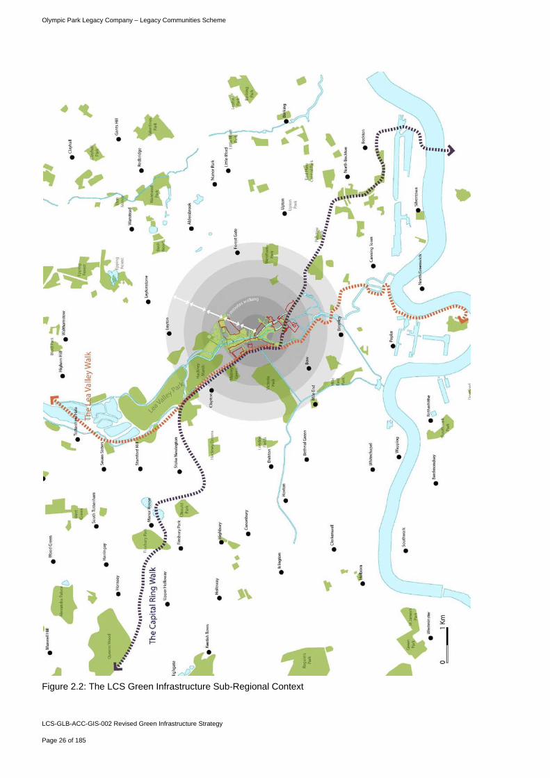
2.2 Green Infrastructure in Context
2.2.1 The future Queen Elizabeth Olympic Park lies in a strategic position, at the junction of four East London
boroughs: Hackney, Waltham Forest, Tower Hamlets and Newham. The wider area includes a number of
notable east London open spaces such as Victoria Park to the west, the Lea Valley Regional Park to the
north and south, and West Ham Park and Epping Forest further afield to the north-east.
2.2.2 The Park benefits from a regional and local connections that provide recreational and wildlife corridors.
These provide linkages to the Thames and open countryside via the Lee Valley Regional Park, as well as
the orbital Capital Ring walk, which provide 78 miles of connected open spaces around Greater London.
2.2.3 The Park will provide a recreational destination for a wide area, stretching into the four host boroughs and
beyond, with a considerable urban population living within 30 minutes walking distance of the park.
Olympic Park Legacy Company – Legacy Communities Scheme
LCS-GLB-ACC-GIS-002 Revised Green Infrastructure Strategy
Page 26 of 185
Figure 2.2: The LCS Green Infrastructure Sub-Regional Context
Olympic Park Legacy Company – Legacy Communities Scheme
LCS-GLB-ACC-GIS-002 Revised Green Infrastructure Strategy
Page 27 of 185
2.3 Post Games Transformation Parklands: The Starting Point for Legacy Communities
Scheme Green Infrastructure
2.3.1 Much of the strategic green infrastructure that will benefit the Legacy Communities Scheme will be in place
as part of the Post Games Transformation Parklands, due to open in 2013/14.
2.3.2 This will deliver a high quality network of metropolitan parkland for east London comprising:
Distinct park areas along the River Lea:
A river valley park to the north combining wetland habitat and active play;
A south plaza for large events, festivals and civic gatherings; and
A central meeting point of rivers and routes where park characters.
6.5km of improved waterways:
A linear park and public promenade along the Lee Navigation and Bowback Rivers; and
Riverside walkways and towpaths;
A diversity of landscapes:
Approximately 102 ha of metropolitan open space;
Over 45 ha of Biodiversity Action Plan area;
Over 6 ha of woodlands, hedgerows and other semi-natural habitats; and
Children’s play areas, civic plazas, neighbourhood squares and gardens.
Legacy facilities:
Multi-Use Arena;
VeloPark with cycle tracks and trails;
The ArcelorMittal Orbit within the South Plaza;
Allotments;
Reconfigured Olympic Stadium with community facilities and athletics track; and
Eton Manor.
Olympic Park Legacy Company – Legacy Communities Scheme
LCS-GLB-ACC-GIS-002 Revised Green Infrastructure Strategy
Page 28 of 185
2.4 Green Infrastructure within the Legacy Communities Scheme
2.4.1 With this substantial existing commitment, it will be important to ensure that the LCS capitalises on
opportunities to enhance Green Infrastructure networks and to maximise the potential for open space,
natural environments and recreational/play space elements within the LCS to enhance the future Queen
Elizabeth Olympic Park as a place to live, work and play.
2.4.2 The Revised Green Infrastructure Strategy seeks to ensure that Green Infrastructure within the LCS
scheme meets strategic commitments and is policy compliant, is integrated with its wider context and
maximises opportunities to enhance biodiversity and adapt to climate change.
Strategic Objectives
2.4.3 The green infrastructure within the LCS scheme seeks to capitalise on the context of the future Queen
Elizabeth Olympic Park and the sub-region by providing an interconnected series of spaces within the park
and LCS scheme, with strong green connections to other parts of London.
2.4.4 The LCS Revised Green Infrastructure Strategy is underpinned by the following key objectives:
1. An integrated approach to Green Infrastructure:
Maximising connections into the Post Games Transformation Parklands from LCS development areas;
Providing east-west “Green Corridors” along major routes. This will seek to enhance connectivity
across the park for people and habitats;
Complementing the blue network – maximising the use of existing water ways within the park for
recreation and wildlife; and
Ensuring Climate Change adaptation measures are considered within all Green Infrastructure
elements.
2. Meeting open space commitments
Ensuring the LCS assists in meeting the strategic requirements to accommodate at least 102 ha of
Metropolitan Open Space within the future Queen Elizabeth Olympic Park;
Ensuring the LCS is served by an open space hierarchy of formal, informal and recreational space that
meets planning policy requirements; and
Olympic Park Legacy Company – Legacy Communities Scheme
LCS-GLB-ACC-GIS-002 Revised Green Infrastructure Strategy
Page 29 of 185
Providing multifunctional space that is responsive to community needs, incorporates wildlife rich
habitats, helps manage surface water and provides high quality local environment.
3. Integrating biodiversity
Ensuring the LCS assists in meeting the Biodiversity Action Plan requirement of 45 ha of BAP habitats
across the future Queen Elizabeth Olympic Park; and
Integrating BAP habitats within LCS development through provision of multi-functional open spaces,
provision of green roofs and the integration of greenspace and habitats into the streetscape and public
realm.
4. Provision of spaces for recreation and play within LCS neighbourhoods:
Provision of local parks and squares, pocket parks, private and communal gardens and other areas for
local recreation and residential amenity; and
Providing playable space for children and young people.
5. Ensuring climate change adaptation is a consideration in all Green infrastructure elements:
Maximising green and blue spaces to help reduce urban heat islands;
Consideration of water sensitive design to reduce the risk of surface water flooding and to increase
evapo-transpirative cooling;
Planting large canopy deciduous trees along streets and in the public realm, to provide summer shade
and shelter from winter wind; and
Inclusion of green roofs, green walls and permeable paving on residential streets, where traffic flow is
minimal.
6. Long term management
Establishing design codes for the delivery of multifunctional green infrastructure throughout the
development of the LCS;
Providing long term management and maintenance guidance for inclusion in developing the Estates
Management Plan for the future Queen Elizabeth Park;

Olympic Park Legacy Company – Legacy Communities Scheme
LCS-GLB-ACC-GIS-002 Revised Green Infrastructure Strategy
Page 30 of 185
Ensuring that high quality open space is maintained for community and wildlife benefit; and
Ensuring that habitats are maintained in accordance with the LCS Biodiversity Action Plan (BAP) in
appendix 2.
LCS-GLB-ACC-GIS-002 Revised Green Infrastructure Strategy
Page 31 of 185
Planning Context
Olympic Park Legacy Company – Legacy Communities Scheme
LCS-GLB-ACC-GIS-002 Revised Green Infrastructure Strategy
Page 32 of 185
3.1.1 The Revised Green Infrastructure strategy has been prepared in response to site specific commitments,
together with national, regional and local planning policy and guidance covering biodiversity, open space
provision, play, sport and recreation. Where applicable, specific standards are cited that form a basis for
provision across the Park.
3.2 Future Queen Elizabeth Olympic Park Green Infrastructure - Planning Commitments
3.2.1 The future Queen Elizabeth Olympic Park has been subject to the following previous planning applications
that set a series of commitments and principles to be brought forward through the development of the
Olympics and the Legacy Communities Scheme:
2007 Olympic, Paralympic & Legacy Transformation Planning Permissions; and
2009 Parkland and Public Realm Post Games Transformation Permission.
3.2.2 Based upon conditions and Section 106 agreements attached to the above permissions, the following
overarching Green Infrastructure commitments must be secured through the Games and Post Games
Transformation development of the Olympic Park (of which the Legacy Communities Scheme forms part):
3.2.3 102ha Metropolitan Open Land – This requirement is set out in Condition LTD.22 of the Olympic,
Paralympic & Legacy Transformation Planning Permissions (07/90010/OUMODA), which requires:
“That at the conclusion of the Legacy Transformation Development, 102ha of Open Space shall have been
provided in accordance with Plan OLY-OLF-ILL-DWG-STW-SPC-IND-005 and the relevant plans for each
Planning Delivery Zone (drawing OLY-OLF-APP-DWG-PDZx-SPC-PAR-002) and be available for public
use. Unless otherwise agreed by the Local Planning Authority, all of this open space shall be designated to
meet the criteria in the London Plan for designations as Metropolitan Open Land and be available for public
use as public open space for amenity and recreational purposes”.
3.2.4 45ha commitment to create habitats - set out in the Olympic Park Biodiversity Action Plan that
accompanied the 2010 Parkland and Public Realm Post Games Transformation Permission. Condition
PPR.11 of the PPR permission requires that all development must comply with the principles of the BAP.
3.2.5 Protection and retention of tree and habitats –condition LTD.1.8 (Protection of trees and habitats) of the
Olympic, Paralympic & Legacy Transformation Planning Permissions (07/90010/OUMODA) requires a
number of trees to be maintained and safeguarded across the Olympic Park. Condition LTD. 1.9
3 Planning Context
Olympic Park Legacy Company – Legacy Communities Scheme
LCS-GLB-ACC-GIS-002 Revised Green Infrastructure Strategy
Page 33 of 185
(Replacement of Trees) places a requirement for any existing tree, or trees planted as part of landscape
schemes to be replaced if removed or lost.
3.3 National Planning Policy Drivers
3.3.1 Green infrastructure is advocated by a number of government bodies, including Natural England, the
government’s advisor on the natural environment of England. Natural England published its Green
Infrastructure Guidance in 2009. This set out the functions and benefits of planning for green infrastructure
and how to embed green infrastructure in the plan making and development management process. Natural
England has also prepared guidance for the creation of green infrastructure as part of the Olympic Park in
2011. This guidance sets out four guiding principles, namely Natural Signature, Natural Resilience, Natural
Health Service and Natural Connections.
3.3.2 Natural England has also prepared an Accessible Natural Greenspace Standard (ANGSt). This provides a
set of benchmarks for ensuring access to places near to where people live.
3.3.3 These standards recommend that people living in towns and cities should have:
an accessible natural greenspace of at least 2 hectares in size, no more than 300 metres (5 minutes
walk) from home;
at least one accessible 20 hectare site within two kilometres of home;
one accessible 100 hectare site within five kilometres of home;
one accessible 500 hectare site within ten kilometres of home; and
one hectare of statutory Local Nature Reserves per thousand population.
3.3.4 CABE published Grey to Green: How We Shift Funding and Skills to Green our Cities in 2009. This study
advocates that an understanding of green infrastructure should be incorporated into every aspect of public
service including development control and transportation.
Olympic Park Legacy Company – Legacy Communities Scheme
LCS-GLB-ACC-GIS-002 Revised Green Infrastructure Strategy
Page 34 of 185
National Planning Policy
3.3.5 The Council of Europe’s European Landscape Convention (ELC) was adopted by the UK in March 2007.
This seeks the integration of landscapes into all relevant areas of policy. Planning for green infrastructure
is aligned with the key principles of the ELC and can assist in achieving its objectives.
3.3.6 At present there is no single planning policy statement relating to green infrastructure. Rather planning
policy deals with specific green infrastructure functions such as biodiversity or flooding. Current Planning
Policy Statements (PPS) and Planning Policy Guidance (PPG) are likely to be replaced by the National
Planning Policy Framework (NPPF) during the LCS determination period.
3.3.7 Planning Policy Statement 12 (PPS12): Local Spatial Planning recognises the importance of planning for
green infrastructure. PPS12 defines green infrastructure as:
“a network of multi-functional green space, both new and existing, both rural and urban, which supports
the natural and ecological processes and is integral to the health and quality of life of sustainable
communities”.
3.3.8 The consultation draft PPS Planning for a Natural and Health Environment will set out national planning
policy relating to the natural environment, green infrastructure, open space, sport, recreation and play. It is
set to replace PPS9, PPS17 and parts of PPS7 and PPG20. The draft PPS seeks to ensure that
development protects, and where possible enhances the natural environment, conserves the countryside
and provides an appropriate quantity and range of types of open and green spaces to meet the needs of a
community.
3.3.9 There is an increasingly greater emphasis upon the co-ordination of green infrastructure at the National
Level and this is likely to increase over time. The historic emphasis on developing a strong network of
biodiversity-rich open space within the Olympic Park and LCS lends itself to reflecting these national aims.
It will be important to ensure that these national drivers are integrated into the LCS strategy.
3.4 Local and Regional Drivers
Open Space Policy Context
3.4.1 Specific planning policy relating to LCS open space and green infrastructure is contained within the
London Plan and the Borough’s Local Development Frameworks.
3.4.2 The London Plan includes a number of specific policies and standards relating to open space provision. Of
Olympic Park Legacy Company – Legacy Communities Scheme
LCS-GLB-ACC-GIS-002 Revised Green Infrastructure Strategy
Page 35 of 185
particular relevance to the LCS are the following policies:
3.4.3 Policy 2.18 - Green infrastructure: the network of open and natural spaces – This Policy places a strategic
emphasis on the protection, promotion, expansion and management of London’s green infrastructure of
multi-functional green and open spaces. This identifies a requirement to secure benefits including
biodiversity, landscape, culture, building a sense of place, the economy, sport, recreation, local food
production, mitigating and adapting to climate change, water management and the social benefits that
promote individual and community health and well being.
3.4.4 The Policy states that the Mayor will pursue the delivery of green infrastructure by working in partnership
with all relevant bodies including the Green Area Partnerships, and has published the East London Green
Grid Framework (2008) Supplementary Planning Guidance to apply the principles of the East London
Green Grid across a wider area.
3.4.5 The Policy seeks to ensure that new development enhances London’s green infrastructure, and should
contribute to addressing needs for regional or metropolitan parks where deficiencies exist. It states that
development proposals should incorporate elements of open space that are integrated into the wider
network of green infrastructure, and encourage the linage of green infrastructure to the wider public realm
to improve accessibility for all and develop new links including Green Corridors and Green Chains, and the
innovative use of street trees.
Policy 7.17 – Metropolitan Open Land (MOL)
3.4.6 The London Plan states that to designate land as MOL boroughs need to establish that the land meets at
least one of the following criteria:
it contributes to the physical structure of London by being clearly distinguishable from the built up area;
it includes open air facilities, especially for leisure, recreation, sport, the arts and cultural activities, which
serve either the whole or significant parts of London;
it contains features or landscapes (historic, recreational, biodiversity) of either national or metropolitan
value; and
it forms part of a Green Chain or a link in the network of green infrastructure and meets one of the above
criteria.
3.4.7 This policy supports the current extent of MOL and its extension in appropriate circumstances. It seeks to
ensure that protection is given to MOL and inappropriate development should be refused except in
Olympic Park Legacy Company – Legacy Communities Scheme
LCS-GLB-ACC-GIS-002 Revised Green Infrastructure Strategy
Page 36 of 185
exceptional circumstances.
Policy 7.18 – Protecting local natural space and addressing local deficiency
3.4.8 The London Plan identifies that local open spaces, as part of London’s multi-functional green infrastructure
are key to improving health and biodiversity. Policy 7.18 places a requirement on borough’s to assess local
open space needs to include appropriate designations and policies for their protection; ensure future open
space needs are accounted for in Opportunity Areas, Regeneration Areas, Intensification Areas and other
local areas.
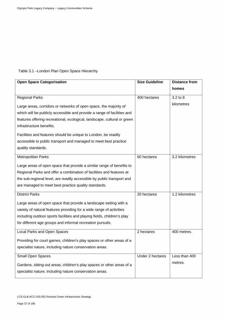
3.4.9 The Policy states that boroughs should identify areas of public open space deficiency based upon the
following defined open space hierarchy:
Olympic Park Legacy Company – Legacy Communities Scheme
LCS-GLB-ACC-GIS-002 Revised Green Infrastructure Strategy
Page 37 of 185
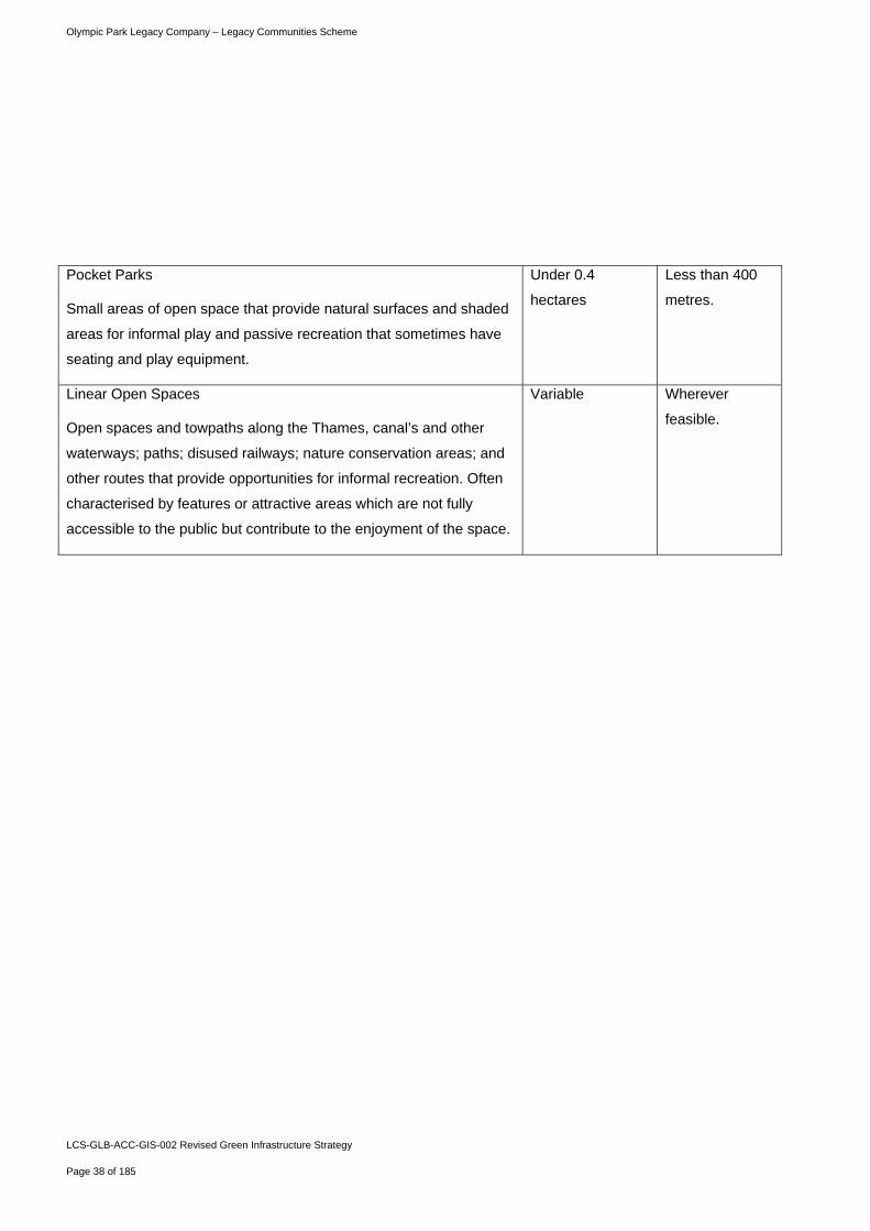
Table 3.1 –London Plan Open Space Hierarchy
Open Space Categorisation Size Guideline Distance from
homes
Regional Parks
Large areas, corridors or networks of open space, the majority of
which will be publicly accessible and provide a range of facilities and
features offering recreational, ecological, landscape, cultural or green
infrastructure benefits.
Facilities and features should be unique to London, be readily
accessible to public transport and managed to meet best practice
quality standards.
400 hectares 3.2 to 8
kilometres
Metropolitan Parks
Large areas of open space that provide a similar range of benefits to
Regional Parks and offer a combination of facilities and features at
the sub-regional level, are readily accessible by public transport and
are managed to meet best practice quality standards.
60 hectares 3.2 kilometres
District Parks
Large areas of open space that provide a landscape setting with a
variety of natural features providing for a wide range of activities
including outdoor sports facilities and playing fields, children’s play
for different age groups and informal recreation pursuits.
20 hectares 1.2 kilometres
Local Parks and Open Spaces
Providing for court games, children’s play spaces or other areas of a
specialist nature, including nature conservation areas.
2 hectares 400 metres.
Small Open Spaces
Gardens, sitting-out areas, children’s play spaces or other areas of a
specialist nature, including nature conservation areas.
Under 2 hectares Less than 400
metres.
Olympic Park Legacy Company – Legacy Communities Scheme
LCS-GLB-ACC-GIS-002 Revised Green Infrastructure Strategy
Page 38 of 185
Pocket Parks
Small areas of open space that provide natural surfaces and shaded
areas for informal play and passive recreation that sometimes have
seating and play equipment.
Under 0.4
hectares
Less than 400
metres.
Linear Open Spaces
Open spaces and towpaths along the Thames, canal’s and other
waterways; paths; disused railways; nature conservation areas; and
other routes that provide opportunities for informal recreation. Often
characterised by features or attractive areas which are not fully
accessible to the public but contribute to the enjoyment of the space.
Variable Wherever
feasible.
Olympic Park Legacy Company – Legacy Communities Scheme
LCS-GLB-ACC-GIS-002 Revised Green Infrastructure Strategy
Page 39 of 185
3.4.10 This hierarchy will be utilised in ensuring sufficient provision of open space is included within the LCS
scheme.
3.4.11 Supplementary Planning Guidance: Sustainable design and construction provides more detailed guidance
for Local Planning Authorities on how to implement the London Plan policies. It explains the principles of
sustainable design and construction and how they should be implemented in London. This sets out the
following possible open space requirements to which Borough must respond:
No net loss of publicly accessible open space;
Net gain of publicly accessible open space (Mayor’s Preferred Standard); and
Create appropriate new open, green, publicly accessible spaces where these can redress identified
areas of deficiency of public open space.
3.4.12 The LCS site lies across the boundaries of the London Boroughs of Hackney, Newham and Tower
Hamlets. Although the LCS application does not cover the London Borough of Waltham Forest, it is
immediately adjacent to the borough boundary and has therefore been considered as part of this strategy.
3.4.13 Each of the Boroughs’ adopted and forthcoming local plans contain specific policies on open space. These
are as follows:
London Borough of Hackney adopted Core Strategy Policy 26 sets out the approach to the Open Space
Network and states that there will be “no net loss in open space” within the Borough. Saved Unitary
Development Plan policy EQ12 states that areas identified as MOL should be predominantly kept in
open use;
London Borough of Newham adopted UDP policy S39, Leisure, Recreation and Open Space seeks to
reduce the overall deficiency in open space across Newham by protecting existing open space and
seeking new provision of publicly accessible space. This is supplemented by open space policies OS1-
13. The draft Core Strategy Policy INF6 Green Infrastructure seeks to improve quality and accessibility
of existing open spaces and ensure new development includes adequate open space for residents;
London Borough of Tower Hamlets saved UDP policy OS6 seeks to protect areas of MOL from
development. OS7 states that any loss of open space will not be allowed unless development is ancillary
to and complements the outdoor recreational use; and
London Borough of Waltham Forest saved UDP policies ENV1 seeks to protect and provide new open
spaces, ENV4 and 5 seek to protect areas of MOL from development.
Olympic Park Legacy Company – Legacy Communities Scheme
LCS-GLB-ACC-GIS-002 Revised Green Infrastructure Strategy
Page 40 of 185
The LCS Revised Green Infrastructure Strategy seeks to demonstrate how the strategic open space
requirements are met. This includes the site specific requirement for the LCS to contribute towards 102 ha
of MOL across the future Queen Elizabeth Olympic Park, as well as demonstrating that the LCS will be
adequately served by an appropriate hierarchy of open space in accordance with London Plan policies and
Borough local plans.
Play and Recreation Policy Context
3.4.14 With a future residential population of approximately 13,500 and an emphasis upon attracting families to
live within the future Queen Elizabeth Olympic Park, it is essential that open spaces within the area are
suitable to meet the play and recreation needs of residents.
3.4.15 Policy on Sports Facilities is set out in London Plan policy 3.20. This policy supports development
proposals that increase or enhance the provision of sports and recreation facilities and resists any net loss
of sports and recreation facilities, including playing fields. The policy places a requirement on Boroughs to
assess the need for sports and recreation facilities in line with PPG 17 at the local and sub regional level
regularly, and secure sites for a range of sports facilities.
3.4.16 London Plan Policy 3.6 - Children and young people’s play and informal recreation facilities sets out the
Mayor’s policy commitments on play space across the Capital. This is supplemented by further planning
guidance as part of an SPG.
3.4.17 This Policy commits to ensuring that all children and young people have safe access to good quality, well
designed, secure and stimulating play and informal recreation provision, incorporating trees and greenery.
It states that development proposals that include housing must include play and informal recreation
provision based on the expected child population generated by the scheme and an assessment of future
needs. The Policy refers to the Supplementary Planning Guidance Providing for Children and Young
People’s Play and Informal Recreation (2008) as providing guidance to assist in this process. This will be a
key consideration for future developers and forms the basis for the play space strategy set out in the
section five.
3.4.18 The SPG provides guidance to London boroughs on meeting play and recreation needs for children and
young people aged 18 or under.
3.4.19 The SPG identifies a series of benchmark standards that should be applied within London boroughs to
ensure minimum requirements for play provision, reflective of local needs. This identifies a minimum
Olympic Park Legacy Company – Legacy Communities Scheme
LCS-GLB-ACC-GIS-002 Revised Green Infrastructure Strategy
Page 41 of 185
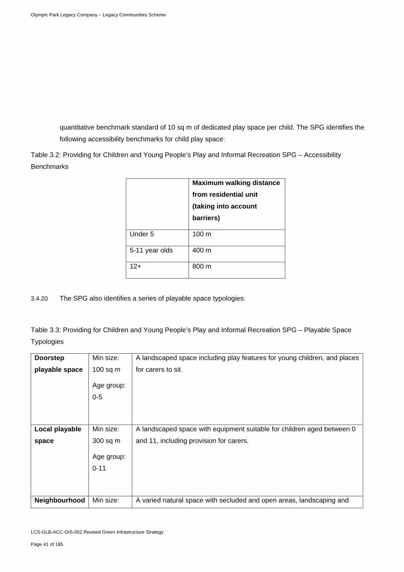
quantitative benchmark standard of 10 sq m of dedicated play space per child. The SPG identifies the
following accessibility benchmarks for child play space:
Table 3.2: Providing for Children and Young People’s Play and Informal Recreation SPG – Accessibility
Benchmarks
Maximum walking distance
from residential unit
(taking into account
barriers)
Under 5 100 m
5-11 year olds 400 m
12+ 800 m
3.4.20 The SPG also identifies a series of playable space typologies:
Table 3.3: Providing for Children and Young People’s Play and Informal Recreation SPG – Playable Space
Typologies
Doorstep
playable space
Min size:
100 sq m
Age group:
0-5
A landscaped space including play features for young children, and places
for carers to sit.
Local playable
space
Min size:
300 sq m
Age group:
0-11
A landscaped space with equipment suitable for children aged between 0
and 11, including provision for carers.
Neighbourhood Min size: A varied natural space with secluded and open areas, landscaping and
Olympic Park Legacy Company – Legacy Communities Scheme
LCS-GLB-ACC-GIS-002 Revised Green Infrastructure Strategy
Page 42 of 185
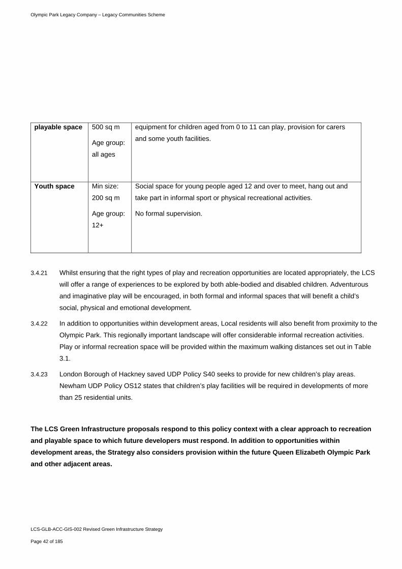
playable space 500 sq m
Age group:
all ages
equipment for children aged from 0 to 11 can play, provision for carers
and some youth facilities.
Youth space Min size:
200 sq m
Age group:
12+
Social space for young people aged 12 and over to meet, hang out and
take part in informal sport or physical recreational activities.
No formal supervision.
3.4.21 Whilst ensuring that the right types of play and recreation opportunities are located appropriately, the LCS
will offer a range of experiences to be explored by both able-bodied and disabled children. Adventurous
and imaginative play will be encouraged, in both formal and informal spaces that will benefit a child’s
social, physical and emotional development.
3.4.22 In addition to opportunities within development areas, Local residents will also benefit from proximity to the
Olympic Park. This regionally important landscape will offer considerable informal recreation activities.
Play or informal recreation space will be provided within the maximum walking distances set out in Table
3.1.
3.4.23 London Borough of Hackney saved UDP Policy S40 seeks to provide for new children’s play areas.
Newham UDP Policy OS12 states that children’s play facilities will be required in developments of more
than 25 residential units.
The LCS Green Infrastructure proposals respond to this policy context with a clear approach to recreation
and playable space to which future developers must respond. In addition to opportunities within
development areas, the Strategy also considers provision within the future Queen Elizabeth Olympic Park
and other adjacent areas.
Olympic Park Legacy Company – Legacy Communities Scheme
LCS-GLB-ACC-GIS-002 Revised Green Infrastructure Strategy
Page 43 of 185
Biodiversity and Habitats Policy Context
3.4.24 The London Plan sets out a strong approach to the protection and enhancement of biodiversity and
habitats, as an integrated component with green infrastructure and the built environment.
3.4.25 Policy 7.19 of the London Plan seeks to ensure a proactive approach to the protection, promotion and
management of biodiversity in support of the Mayor’s Biodiversity Strategy.
3.4.26 This approach is supplemented by London Plan Policy 2.18 on Green Infrastructure and Open Space, 5.3
on sustainable design and construction, Policy 5.10 which promotes urban greening, Policy 5.11 which
states that Major development proposals should be designed to include roof, wall and site planting,
especially green roofs and walls where feasible. Policy 7.18 sets out the approach to protecting natural
space and addressing local deficiencies.
3.4.27 The London Plan Supplementary Planning Guidance Sustainable Design and Construction (2006) states
that there should be no net loss of biodiversity and access to nature on development sites, whilst the
Mayor seeks to ensure a net gain of biodiversity and access to nature on the development site (Mayor’s
Preferred Standard).
3.4.28 This London-wide approach is complemented by each of the Borough’s through their Core Strategies and
Local Development Frameworks. Hackney Core Strategy Policy 27 and draft Newham Core Strategy
Policy SC4 state that both councils will protect, conserve and enhance biodiversity through development.
3.4.29 Policy SP04 of the Tower Hamlets Core Strategy promotes and supports green roofs, green terraces and
other measures to green the built environment and seeks to protect and enhance biodiversity value. Whilst
Policies SO12 and 13 Creating a Green and a Blue Grid seeks to develop a well connected network of
Green and Blue spaces.
3.4.30 Policy CS6 of the Waltham Forest Core Strategy seeks to protect and enhance green infrastructure and
biodiversity and to maximise access to open spaces across the Borough.
3.4.31 The Regional and Local planning policy context therefore is clearly protective of existing biodiversity as
part of a wider green infrastructure context, and policy strongly supports the enhancement and expansion
of biodiversity and habitats through new development.
The Revised Green Infrastructure Strategy seeks to set out how biodiversity can be optimised within the
LCS scheme and integrated within the open space landscape, whilst playing a role in climate change
adaptation.

Olympic Park Legacy Company – Legacy Communities Scheme
LCS-GLB-ACC-GIS-002 Revised Green Infrastructure Strategy
Page 44 of 185
Climate Change Adaptation Policy Context
3.4.32 The LCS seeks to ensure that people, buildings and buildings are able to manage the risks proposed by a
changing climate. The LCS is supported by a range of proposed measures to assist in these aims and the
Revised Green Infrastructure Strategy has an important role to play in achieving this.
3.4.33 The policy context for climate change is continually evolving at present with a legal obligation set out in the
Climate Change Act which requires a national risk assessment and programme for adaptation to be laid
before Parliament in 2012. Climate change adaptation, with a particular emphasis on the role of green
infrastructure, is increasingly reflected in emerging regional and local policies.
3.4.34 The GLA has recently issued a draft Climate Change Adaptation Strategy (2010) setting out likely climate
change impacts affecting London and a series of responses. A key proposal within this draft strategy is for
an urban greening programme to increase the quality and quantity of greenspace and vegetation in
London to act as a buffer from floods and hot weather
3.4.35 The London Plan outlines a series of policies that are supported by London’s Adaptation Strategy. This
includes policies to promote urban greening including the creation of green roofs and sustainable
drainage. Such proposals are also included in the adopted/emerging Core Strategies for the Olympic
boroughs.
The LCS Revised Green Infrastructure Strategy seeks to ensure that climate change adaptation measures
are integral to the scheme and form a key consideration in the design of new spaces, play areas, public
realm and buildings, whilst seeking to maximise the benefits of biodiversity and habitats creation.
Other policies of relevance to green infrastructure
3.4.36 In addition to specific policies on open space, play space and biodiversity, the following policy and
guidance will be of relevance to the LCS Green Infrastructure Strategy:
3.4.37 London Plan Policy 7.21 – Trees and Woodlands. - This policy seeks to protect, maintain and enhance
trees and woodland. It places a requirement upon Boroughs to produce a Tree Strategy, linked to the
Borough’s Open Space Strategy;
3.4.38 Policy 7.22 – Land for Food - This policy supports farming and land based sectors in London, whilst
encouraging the use of land for growing food near to urban communities. It places a requirement on
Olympic Park Legacy Company – Legacy Communities Scheme
LCS-GLB-ACC-GIS-002 Revised Green Infrastructure Strategy
Page 45 of 185
Boroughs to protect existing allotments and identify other potential spaces that could be used for
community gardening. It seeks to promote innovative approaches to the provision of spaces such as the
use of green roofs;
3.4.39 Policy 7.24 – Blue Ribbon Network – Identifies the Blue Ribbon Network as a strategically important series
of linked spaces. It prioritises uses of waterspace and adjoining land for water related purposes, in
particular passenger and freight transport, increasing the use of the Blue Ribbon Network for passengers
and tourism. This identifies the River Lea as a location where passenger and tourist river services will be
promoted;
3.4.40 Policy 7.26 – Increasing the use of the Blue Ribbon Network for freight transport - This policy identifies the
River Lea, as part of the Blue Ribbon Network, as a location that will be promoted to transport freight;
3.4.41 Policy 7.27 – Blue Ribbon Network: supporting infrastructure and recreational use. This policy seeks to
enhance the River Lea, as part of the Blue Ribbon Network for the use of waterborne sport, leisure
activities, and states that existing infrastructure will be protected and new facilities will be promoted;
3.4.42 Policy 7.28 – Restoration of the Blue Ribbon Network - This policy promotes the restoration and
enhancement of the River Lea, as part of the Blue Ribbon Network. It identifies the potential for
naturalising river channels, increasing habitat value and protecting the open character of the network; and
3.4.43 GLA Supplementary Planning Guidance: East London Green Grid Framework (2008) - The SPG provides
guidance on implementation of the green grid strategy to provide an interlinked network of high quality,
multi-functional green spaces that connect with town centres, public transport hubs, the countryside, River
Thames, employment and residential areas across east London.
LCS-GLB-ACC-GIS-002 Revised Green Infrastructure Strategy
Page 46 of 185
Meeting Open Space Commitments and Requirements
Olympic Park Legacy Company – Legacy Communities Scheme
LCS-GLB-ACC-GIS-002 Revised Green Infrastructure Strategy
Page 47 of 185
4.1.1 This section explains how existing commitments for open space will be accommodated within the Legacy
Communities Scheme as part of the future Queen Elizabeth Olympic Park.
4.1.2 This sets out implications of the LCS on existing committed Post Games Transformation Parklands and
Public Realm, together with spatial requirements as established through local and national open space
standards, and how the LCS will conform with open space hierarchy standards set out within the London
Plan.
4.2 Meeting the Open Space Commitments
Olympic Facilities and their Legacy Transformation Application (2007) Ref: 07/90010/OUMODA
4.2.1 The requirement for 102 ha of publicly accessible open space, with the potential of being designated
Metropolitan Open Land (MOL) was established through the 2007 Facilities and their Legacy
Transformation Application and applies to the entire future Queen Elizabeth Olympic Park.
4.2.2 The 2007 Planning Applications and EIA were accompanied by an Open Space Strategy that provided a
summary of the open space proposals within the Olympic Applications. It included a brief assessment of
existing and proposed open spaces, including outdoor sports facilities, semi-natural habitats, amenity
green space and open water within the application areas.
4.2.3 The Legacy Open Space, comprising Post Games Transformation Parklands and Public Realm, as
approved within the 2007 permissions is illustrated in Figure 4.1.
4 Meeting Open Space Commitments and Requirements
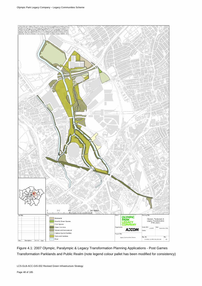
Olympic Park Legacy Company – Legacy Communities Scheme
LCS-GLB-ACC-GIS-002 Revised Green Infrastructure Strategy
Page 48 of 185
Figure 4.1: 2007 Olympic, Paralympic & Legacy Transformation Planning Applications - Post Games
Transformation Parklands and Public Realm (note legend colour pallet has been modified for consistency)
Olympic Park Legacy Company – Legacy Communities Scheme
LCS-GLB-ACC-GIS-002 Revised Green Infrastructure Strategy
Page 49 of 185
Olympic Park: Post Games Transformation & Public Realm Planning Application and Legacy
Transformation Highways Planning Permission (2010)
4.2.4 In 2009 a suite of planning applications were submitted which together comprised the Post Games
Transformation (PGT) Parklands and Public Realm (PPR) Planning Applications, together with associated
Legacy Transformation Highways Planning Application. PGT refers to the works undertaken after the
Paralympic Games closing ceremony in September 2012 and lasting until December 2014. The PPR
proposals cover the areas of landscaping that will be created in the PGT period. The PGT PPR were
planned with the development of the LCS in mind, and sought detailed approval for much of the open
space and landscape within the Olympic Park, together with indicative legacy proposals. As such, this
consented scheme shown in figure 4.2 represents the open space baseline from which the LCS begins.
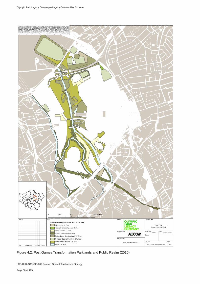
Olympic Park Legacy Company – Legacy Communities Scheme
LCS-GLB-ACC-GIS-002 Revised Green Infrastructure Strategy
Page 50 of 185
Figure 4.2: Post Games Transformation Parklands and Public Realm (2010)
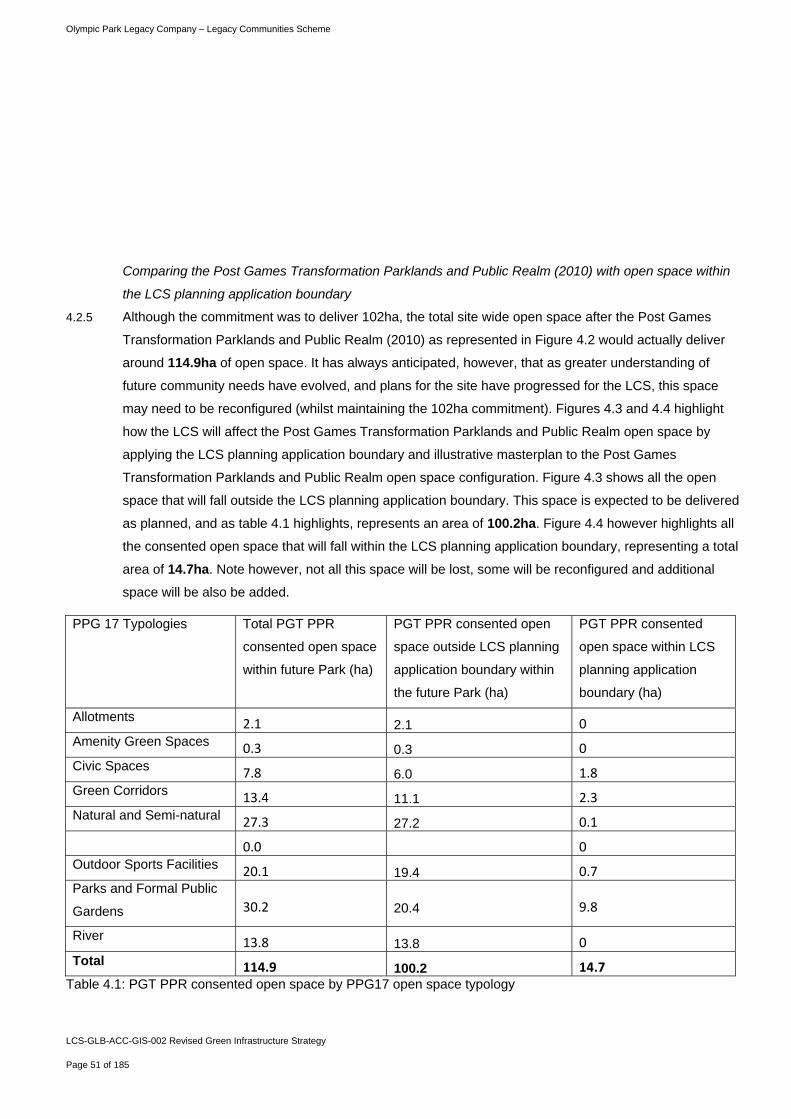
Olympic Park Legacy Company – Legacy Communities Scheme
LCS-GLB-ACC-GIS-002 Revised Green Infrastructure Strategy
Page 51 of 185
Comparing the Post Games Transformation Parklands and Public Realm (2010) with open space within
the LCS planning application boundary
4.2.5 Although the commitment was to deliver 102ha, the total site wide open space after the Post Games
Transformation Parklands and Public Realm (2010) as represented in Figure 4.2 would actually deliver
around 114.9ha of open space. It has always anticipated, however, that as greater understanding of
future community needs have evolved, and plans for the site have progressed for the LCS, this space
may need to be reconfigured (whilst maintaining the 102ha commitment). Figures 4.3 and 4.4 highlight
how the LCS will affect the Post Games Transformation Parklands and Public Realm open space by
applying the LCS planning application boundary and illustrative masterplan to the Post Games
Transformation Parklands and Public Realm open space configuration. Figure 4.3 shows all the open
space that will fall outside the LCS planning application boundary. This space is expected to be delivered
as planned, and as table 4.1 highlights, represents an area of 100.2ha. Figure 4.4 however highlights all
the consented open space that will fall within the LCS planning application boundary, representing a total
area of 14.7ha. Note however, not all this space will be lost, some will be reconfigured and additional
space will be also be added.
PPG 17 Typologies Total PGT PPR
consented open space
within future Park (ha)
PGT PPR consented open
space outside LCS planning
application boundary within
the future Park (ha)
PGT PPR consented
open space within LCS
planning application
boundary (ha)
Allotments 2.1 2.1 0 Amenity Green Spaces 0.3 0.3 0 Civic Spaces 7.8 6.0 1.8 Green Corridors 13.4 11.1 2.3 Natural and Semi-natural 27.3 27.2 0.1
0.0 0 Outdoor Sports Facilities 20.1 19.4 0.7 Parks and Formal Public
Gardens 30.2 20.4 9.8
River 13.8 13.8 0 Total 114.9 100.2 14.7
Table 4.1: PGT PPR consented open space by PPG17 open space typology
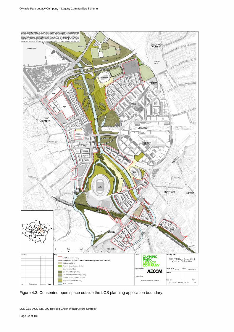
Olympic Park Legacy Company – Legacy Communities Scheme
LCS-GLB-ACC-GIS-002 Revised Green Infrastructure Strategy
Page 52 of 185
Figure 4.3: Consented open space outside the LCS planning application boundary.
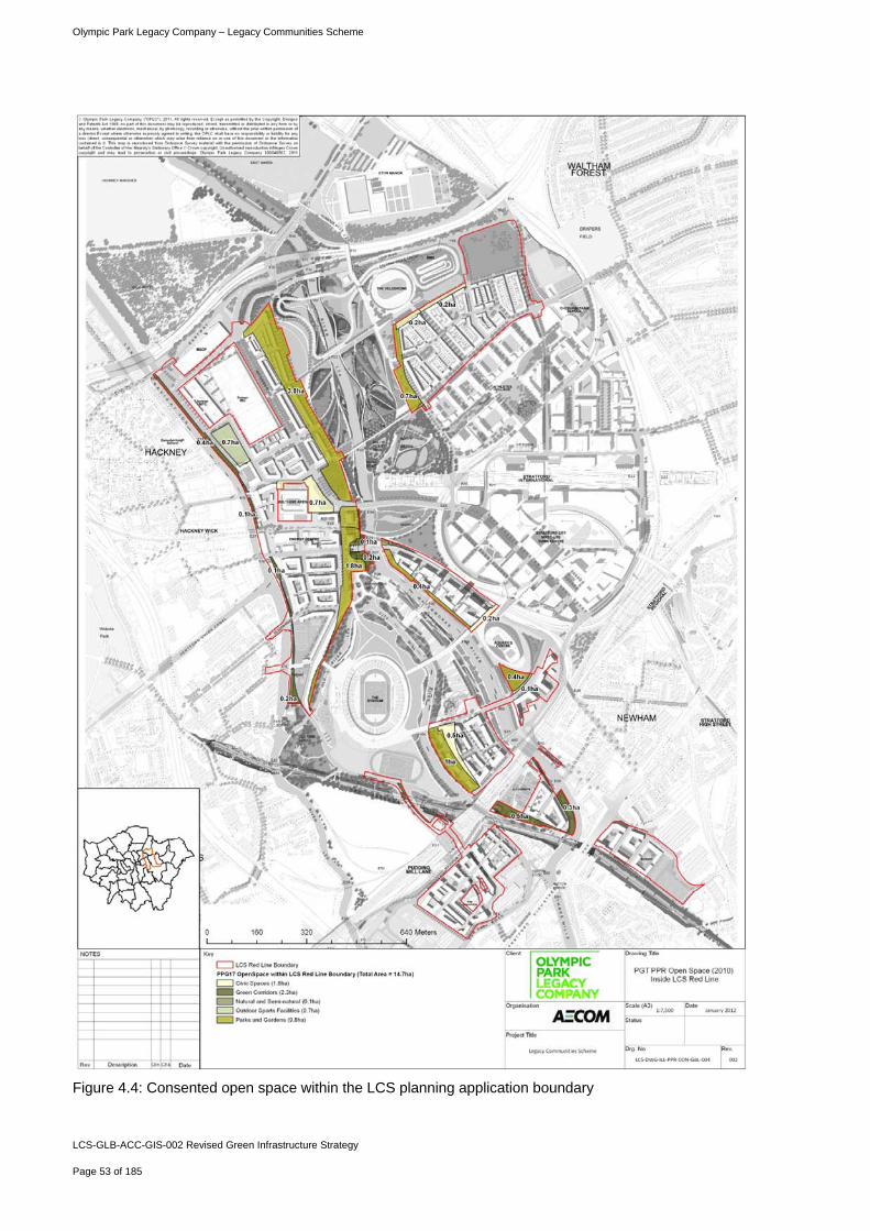
Olympic Park Legacy Company – Legacy Communities Scheme
LCS-GLB-ACC-GIS-002 Revised Green Infrastructure Strategy
Page 53 of 185
Figure 4.4: Consented open space within the LCS planning application boundary
Olympic Park Legacy Company – Legacy Communities Scheme
LCS-GLB-ACC-GIS-002 Revised Green Infrastructure Strategy
Page 54 of 185
How open space provision within the Legacy Communities Scheme compares with Post Games
Transformation and Parklands and Public Realm planning application
4.2.6 The section above shows that 100.2ha of consented open space falls outside of the LCS planning
application boundary. A further 2.5ha of consented open space falling inside the LCS planning application
boundary will remain as planned as shown in. In addition, the LCS will provide 9.9ha of new open space.
As such, there will be a total of 12.4ha of open space within the LCS planning application boundary as
shown in Figure 4.6. As such there will be 12.9ha of open space across the wider Queen Elizabeth
Olympic Park. The Open Space Parameter Plan, Figure 4.13(at the end of this chapter) shows the
parameter plan new areas of open space being applied for.
4.2.7 Figure 4.6 shows the areas that have stayed the same (blue), have been lost (red) or added (green)
across the future Queen Elizabeth Olympic Park.
4.2.8 Table 4.2 compares this with the configuration of PGT PPR consented open space within the LCS
planning application boundary. Appendix 1 provides a breakdown of open space by Planning Delivery
Zone (PDZ).
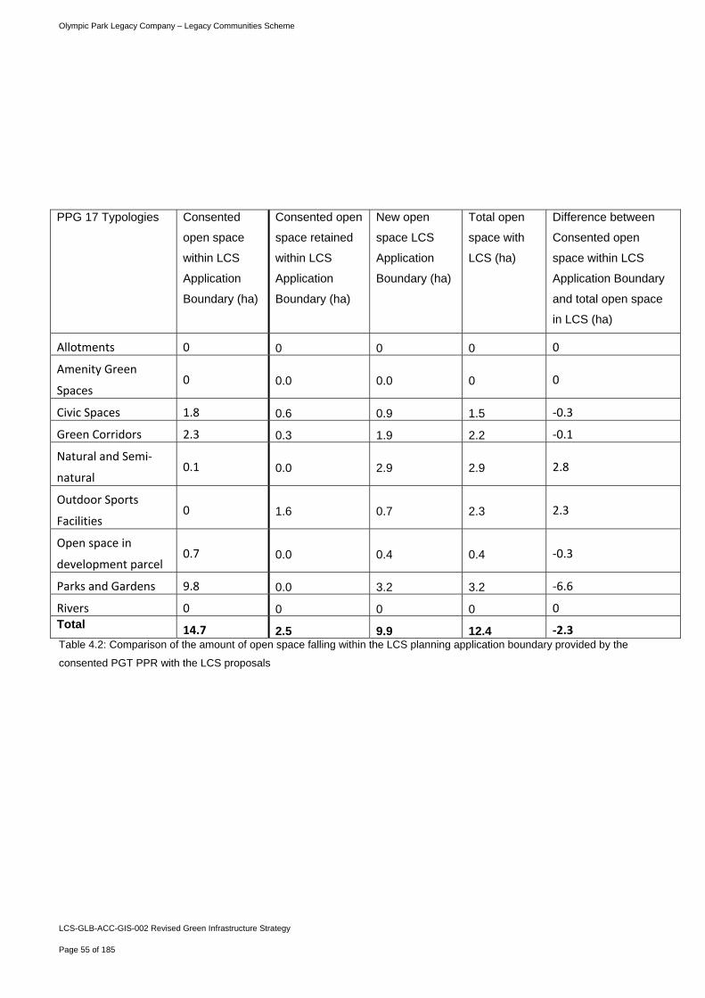
Olympic Park Legacy Company – Legacy Communities Scheme
LCS-GLB-ACC-GIS-002 Revised Green Infrastructure Strategy
Page 55 of 185
PPG 17 Typologies Consented
open space
within LCS
Application
Boundary (ha)
Consented open
space retained
within LCS
Application
Boundary (ha)
New open
space LCS
Application
Boundary (ha)
Total open
space with
LCS (ha)
Difference between
Consented open
space within LCS
Application Boundary
and total open space
in LCS (ha)
Allotments 0 0 0 0 0
Amenity Green
Spaces 0 0.0 0.0 0 0
Civic Spaces 1.8 0.6 0.9 1.5 ‐0.3
Green Corridors 2.3 0.3 1.9 2.2 ‐0.1
Natural and Semi‐
natural 0.1 0.0 2.9 2.9 2.8
Outdoor Sports
Facilities 0 1.6 0.7 2.3 2.3
Open space in
development parcel 0.7 0.0 0.4 0.4 ‐0.3
Parks and Gardens 9.8 0.0 3.2 3.2 ‐6.6
Rivers 0 0 0 0 0 Total 14.7 2.5 9.9 12.4 ‐2.3 Table 4.2: Comparison of the amount of open space falling within the LCS planning application boundary provided by the
consented PGT PPR with the LCS proposals
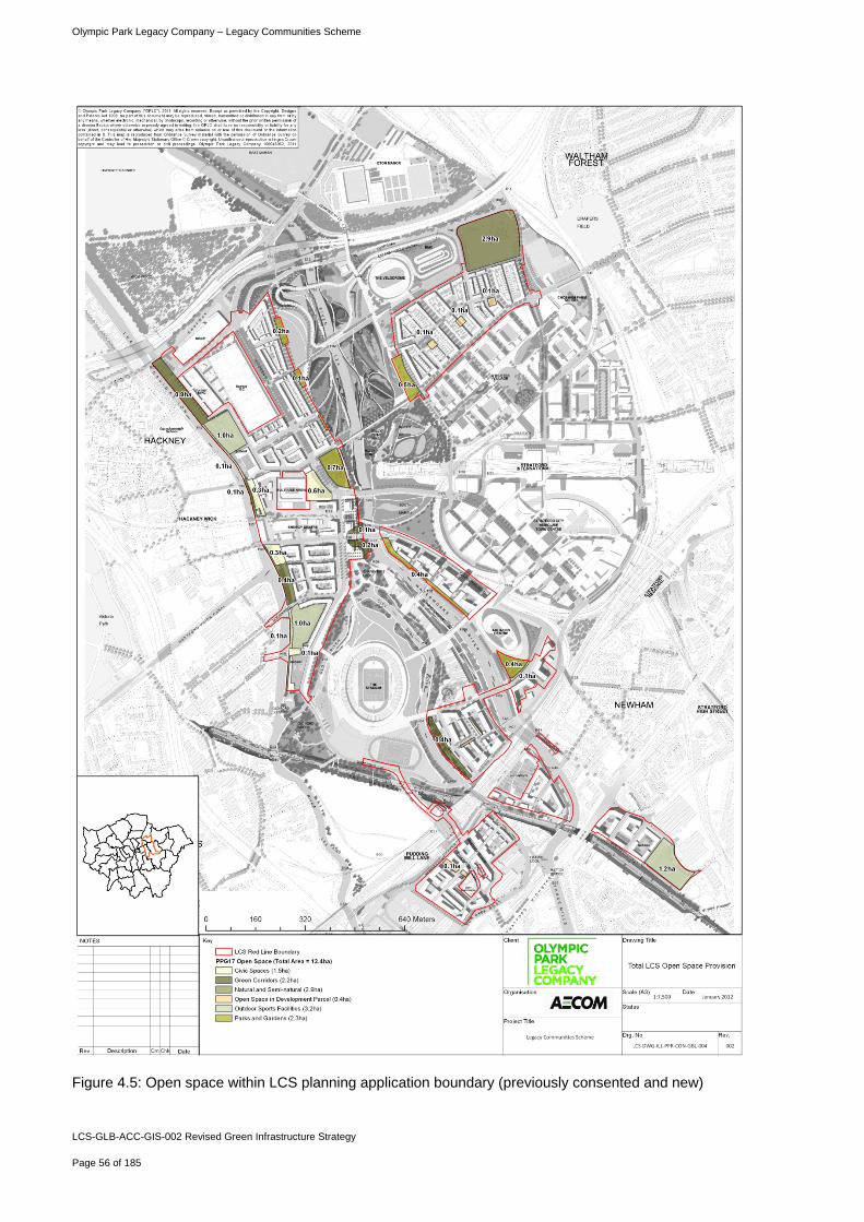
Olympic Park Legacy Company – Legacy Communities Scheme
LCS-GLB-ACC-GIS-002 Revised Green Infrastructure Strategy
Page 56 of 185
Figure 4.5: Open space within LCS planning application boundary (previously consented and new)