LEESBURG OLD AND HISTORIC - Virginia Department of ... · Town of Leesburg in conjunction with the...
63
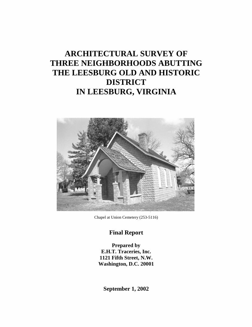
ARCHITECTURAL SURVEY OF THREE NEIGHBORHOODS ABUTTING THE LEESBURG OLD AND HISTORIC DISTRICT IN LEESBURG, VIRGINIA Chapel at Union Cemetery (253-5116) Final Report Prepared by E.H.T. Traceries, Inc. 1121 Fifth Street, N.W. Washington, D.C. 20001 September 1, 2002
-
Upload
truongdieu -
Category
Documents
-
view
216 -
download
1
Transcript of LEESBURG OLD AND HISTORIC - Virginia Department of ... · Town of Leesburg in conjunction with the...
ARCHITECTURAL SURVEY OF THREE NEIGHBORHOODS ABUTTING THE LEESBURG OLD AND HISTORIC
DISTRICT IN LEESBURG, VIRGINIA
Chapel at Union Cemetery (253-5116)
Final Report
Prepared by
E.H.T. Traceries, Inc. 1121 Fifth Street, N.W. Washington, D.C. 20001
September 1, 2002

ARCHITECTURAL SURVEY OF THREE NEIGHBORHOODS
ABUTTING THE LEESBURG OLD AND HISTORIC DISTRICT
IN LEESBURG, VIRGINIA Final Report Prepared by E.H.T. Traceries, Inc.
1121 Fifth Street, N.W. Washington, D.C. 20001
For
The Virginia Department of Historic Resources 2801 Kensington Avenue
Richmond, Virginia 23221
and The Town of Leesburg
25 West Market Street Leesburg, Virginia 20175
(Contact: Kristie Lalire, Preservation Planner, 703/771-2770)
September 1, 2002

Architectural Survey of Three Neighborhoods Abutting the Leesburg Old and Historic District, Leesburg, Virginia E.H.T. Traceries, Inc., September 2002 Page 2 TABLE OF CONTENTS LIST OF MAPS AND ILLUSTRATIONS ................................................................................................... 3 ABSTRACT .................................................................................................................................................. 4 ACKNOWLEDGMENTS ............................................................................................................................. 5 INTRODUCTION ......................................................................................................................................... 6
1. National Park Service Funding and Discrimination Statement................................................... 7 LOCATION MAP OF LEESBURG .............................................................................................................. 8 MAP OF SURVEY AREA ............................................................................................................................ 9 MAP OF LEESBURG NATIONAL REGISTER HISTORIC DISTRICT (Amended) .............................. 10 MAP OF LEESBURG OLD AND HISTORIC DISTRICT (Local)............................................................ 11 HISTORIC CONTEXT ............................................................................................................................... 12 Growth and Development Periods of Leesburg .............................................................................. 12
1. Theme: Domestic ..................................................................................................................... 17 2. Theme: Architecture/Community Planning .............................................................................. 27 3. Theme: Subsistence/Agriculture .............................................................................................. 33 4. Theme: Commerce/Trade ......................................................................................................... 35 5. Theme: Education .................................................................................................................... 36 6. Theme: Religion ....................................................................................................................... 37 7. Theme: Funerary ...................................................................................................................... 37
RESEARCH DESIGN ................................................................................................................................. 39
Objectives/Scope of Work .............................................................................................................. 39 Methodology/Work Plan ................................................................................................................. 40
SURVEY FINDINGS .................................................................................................................................. 45
Leesburg Database Holdings .......................................................................................................... 45 Analysis of Survey Findings ........................................................................................................... 48
RECOMMENDATIONS ............................................................................................................................. 55
BIBLIOGRAPHY ........................................................................................................................................ 60

Architectural Survey of Three Neighborhoods Abutting the Leesburg Old and Historic District, Leesburg, Virginia E.H.T. Traceries, Inc., September 2002 Page 3 LIST OF MAPS Map 1: Location Map of Leesburg .............................................................................. page 9 Map 2: Survey Area ................................................................................................... page 10 Map 3: Leesburg National Register Historic District (Amended) ............................. page 11 Map 4: Leesburg Old and Historic District (Local) ................................................... page 12 LIST OF ILLUSTRATIONS Figure 1: House, 309 North King Street (253-5119) Figure 2: House, 12 Wilson Avenue (253-5130) Figure 3: House, 302 North King Street (253-5122) Figure 4: House, 241 Edwards Ferry Road (253-5069) Figure 5: House, 302 Edwards Ferry Road (253-5074) Figure 6: House, 508 Edwards Ferry Road (253-5104) Figure 7: House, 611 Edwards Ferry Road (253-5112) Figure 8: Garage, 10 Wilson Avenue (253-5129) Figure 9: Shed, 310 Edwards Ferry Road (253-5080) Figure 10: Carriage House, 302 North King Street (253-5122) Figure 11: Workshop and Well, 302 North King Street (253-5122) Figure 12: House, 310 Edwards Ferry Road (253-5080) Figure 13: House, 248 Edwards Ferry Road (253-5072) Figure 14: House, 321 Edwards Ferry Road (253-5091) Figure 15: House, 320 Edwards Ferry Road (253-5090) Figure 16: Former Barn, 18 Wilson Avenue (253-5132) Figure 17: Workshop, 16 Union Street (253-5118) Figure 18: School, 20 Union Street (253-5117) Figure 19: Loudoun Baptist Temple (253-5096) Figure 20: Union Cemetery (253-5116)

Architectural Survey of Three Neighborhoods Abutting the Leesburg Old and Historic District, Leesburg, Virginia E.H.T. Traceries, Inc., September 2002 Page 4 ABSTRACT The Architectural Survey of three neighborhoods in the Town of Leesburg was conducted between December 2001 and September 2002 by the architectural and historic preservation firm of E.H.T. Traceries Inc. under the direction of the Town of Leesburg and the Virginia Department of Historic Resources (VDHR). The project consisted of the reconnaissance survey of seventy-one properties abutting the defined boundaries of the local Leesburg Old and Historic District. This local historic district was designated in 1963 and expanded in 1990 by the Leesburg Town Council. The period of significance for the local historic district has been determined to extend from 1758 to 1950. The Leesburg National Register Historic District was listed in 1970 on the Virginia Landmarks Register and the National Register of Historic Places. This smaller national historic district, which included only the seventy lots platted by Nicholas Minor in 1757, was expanded and amended in 2001 to incorporate synchronic architecture located on the outskirts of the original boundaries of Leesburg, which was expanded numerous times throughout the 19th and 20th centuries. The amendment expanded the designated historic district’s period of significance to 1757 through 1950 and continues to support the areas of significance (architecture and community planning/development). Detailed documentation and intensive survey work supported the original nominations and subsequent expansions/amendments of the local and national historic districts. This work included in-depth research that documented the analogous history, both social and architectural, of the Town of Leesburg from its founding in 1757 to the latter part of the 20th century. This survey and documentation effort, which recorded seventy-one properties, is the fourth phase of on-site survey in the Town of Leesburg. Phase I, conducted in 1998 by HaAR-Historic and Architectural Resources, documented 175 properties in the Nicholas Minor Section of Leesburg. Phase II was performed by GAI Consultants in 1999, recording 215 properties within the Leesburg Old and Historic District. Phase III recorded 221 properties within the remaining areas of the local historic district not documented in the Phase I and II survey efforts. Each survey phase comprehensively documented all standing resources regardless of the building’s age of construction. Individual properties were architecturally defined, physically assessed, photographed with black-and-white film, and documented for their contribution to the local and national historic districts of Leesburg. The survey methodology for this most current survey phase was based on historic maps and previous survey efforts. E.H.T. Traceries, Inc. used the 1853 Yardley Taylor Map of Loudoun County, the 1878 Gray’s New Map of Leesburg, and the Sanborn Fire Insurance Maps to properly identify, date, and evaluate historic resources in the survey areas. The documentation gathered during this architectural survey of Leesburg was entered into a computerized survey database known as the VDHR-Data Sharing Software System (VDHR-DSS). This computer system was developed specifically to meet VDHR's computer needs and desires. VDHR-DSS contains an individual database for the Town of Leesburg. Inclusive of the survey documentation gathered by Traceries, the Leesburg database contains a total of 682

Architectural Survey of Three Neighborhoods Abutting the Leesburg Old and Historic District, Leesburg, Virginia E.H.T. Traceries, Inc., September 2002 Page 5 records. Of these 682 records, 221 were documented in 2000 and seventy-one were documented in 2002 by Traceries. E.H.T. Traceries, Inc. recommends that the boundaries of the Leesburg National Register Historic District should be examined for expansion a second time. The amended historic district expanded the designated historic district’s period of significance to 1757 through 1950, a period of development that is represented by the seventy-one properties documented in this most recent survey. Further, the amended historic district is significant in the areas of architecture and community planning/development, which is also well represented by those properties located in the three neighborhoods abutting the local and national historic districts that were included within this survey phase. ACKNOWLEDGMENTS E.H.T. Traceries Inc. wishes to thank Kristie S. Lalire of the Town of Leesburg and Jane Sullivan at the Thomas Balch Library for their ongoing commitment and support to this project. David Edwards, Paige Weiss, Trent Park, Harrison Cook, and Quatro Hubbard of VDHR also deserve recognition and praise for assisting E.H.T. Traceries Inc. in meeting the needs of the Town and the State. E.H.T. Traceries Inc. would also like to thank the Library of Virginia, Virginia State Archives, VDHR Archives and Evaluation Team, Loudoun County Library, the many local community and neighborhood groups, and the Thomas Balch Local History and Genealogy Library. Additional, Sally Reed Rich provided valuable information on the development of Edwards Ferry Road, which was greatly appreciated by E.H.T. Traceries. A special word of gratitude is sent to the many residents of the Town of Leesburg, who allowed access to their properties and provided valuable information regarding the history of the town, community members, and individual resources.

Architectural Survey of Three Neighborhoods Abutting the Leesburg Old and Historic District, Leesburg, Virginia E.H.T. Traceries, Inc., September 2002 Page 6 INTRODUCTION Project Purpose and Goals The Architectural Survey of three neighborhoods in the Town of Leesburg was the fourth phase of a multi-phase project funded by the Town of Leesburg under the terms of the Virginia Department of Historic Resources’ Certified Local Government (CLG) Grant Program. The Town of Leesburg in conjunction with the Virginia Department of Historic Resources (VDHR) contracted with E.H.T. Traceries Inc. to conduct the survey. The work was to include the on-site documentation of approximately 70 properties, a detailed survey report, and recommendations regarding further study of any, or all, of the resources retaining significance and integrity within the historic context established in the local and national historic district nominations. Scope of Work The project anticipated the survey of those resources not previously identified within the boundaries of local the Leesburg Old and Historic District or the Leesburg National Register Historic District. Each resource was assessed, surveyed, documented, and photographed at the reconnaissance level as appropriate on Virginia Department of Historic Resources Field Forms. This process allowed for a thorough study of each resource, its date of construction substantiated by historic maps, building materials, architectural style, and use. All of the properties surveyed by Traceries were entered into the VDHR on-line Data Sharing Software (DSS). Utilizing the DSS database, a final survey report was produced that presented the findings of the survey and allowed for a comparison and contrast of each of the resources identified. Within the established significance of Leesburg, each resource was assessed for its contribution with recommendations for further study as a potential individual landmark or within an expanded historic district. Staffing Funded by Leesburg in conjunction with VDHR, the Architectural Survey of the Town of Leesburg was contracted to E.H.T. Traceries Inc., an architectural history firm specializing in historic preservation. Laura V. Trieschmann served as Project Director/Senior Architectural Historian, responsible for overseeing the completion of the project, writing the final survey report, and conducting the final assessment of the resources. Architectural historian Robin J. Weidlich oversaw the on-site fieldwork, the DSS entry, and the production of the survey products with the assistance of architectural historian Gerald Maready. The architectural historians were also responsible for the archival research and documentation conducted at local, state, and federal repositories. Jennifer Bunting, Jana Riggle, and Kristie Baynard assisted with the on-site survey fieldwork.

Architectural Survey of Three Neighborhoods Abutting the Leesburg Old and Historic District, Leesburg, Virginia E.H.T. Traceries, Inc., September 2002 Page 7 Funding This publication has been financed in part with Federal funds from the National Park Service, U.S. Department of the Interior. However, the contents and opinion do not necessarily reflect the view or policies of the U.S. Department of the Interior. This program receives Federal financial assistance for identification and protection of historic properties. Under Title VI of the Civil Rights Act of 1964, Section 504 of the Rehabilitation Act of 1973, and the Age Discrimination Act of 1975, as amended, the US Department of the Interior prohibits discrimination on the basis of race, color, national origin, disability or age in its federally assisted programs. If you believe you have been discriminated against in any program, activity, or facility as described above, or if you desire further information please write to: Office for Equal Opportunity, National Park Service, P.O. Box 37127, Washington, D.C. 20240.

Architectural Survey of Three Neighborhoods Abutting the Leesburg Old and Historic District, Leesburg, Virginia E.H.T. Traceries, Inc., September 2002 Page 8
LOCATION MAP OF LEESBURG, VIRGINIA

Architectural Survey of Three Neighborhoods Abutting the Leesburg Old and Historic District, Leesburg, Virginia E.H.T. Traceries, Inc., September 2002 Page 9
SURVEY AREA

Architectural Survey of Three Neighborhoods Abutting the Leesburg Old and Historic District, Leesburg, Virginia E.H.T. Traceries, Inc., September 2002 Page 10
LEESBURG NATIONAL REGISTER HISTORIC DISTRICT BOUNDARIES (Amended)

Architectural Survey of Three Neighborhoods Abutting the Leesburg Old and Historic District, Leesburg, Virginia E.H.T. Traceries, Inc., September 2002 Page 11 LEESBURG OLD AND HISTORIC DISTRICT BOUNDARIES (Local)

Architectural Survey of Three Neighborhoods Abutting the Leesburg Old and Historic District, Leesburg, Virginia E.H.T. Traceries, Inc., September 2002 Page 12 HISTORIC CONTEXT The historic periods referenced in this text are based on significant time frames established by the Virginia Department of Historic Resources. These periods include:
• European Settlement to Society Period (1607-1750) • Colony to Nation Period (1750-1789) • Early National Period (1790-1830) • Antebellum Period (1831-1860) • Civil War Period (1861-1865)
• Reconstruction and Growth Period (1866-1917) • World War I to World War II Period (1918-1945)
• The New Dominion Period (1946-present) The periods of growth in Leesburg vary slightly from those established by the Virginia Department of Historic Resources. These periods are based on the founding, incorporation, and expansion of the town as necessitated by the rising population. The five periods are:
• Phase I (1758-1830) • Phase II (1831-1878) • Phase III (1879-1914) • Phase IV (1915-1960) • Phase V (1961-present)
Growth and Development Periods of Leesburg • Phase I (1758-1830) The Town of Leesburg was created by an act of the Virginia House of Burgesses in 1758 and was laid out by Nicholas Minor. Leesburg, which served as the county seat of Loudoun County, was a market town at the crossroads of the Old Carolina Road (Route 15) and Braddock’s Trail (Route 7). As the population grew, the town was incorporated in 1813 and the boundaries were officially expanded in 1814. Intense development of domestic buildings in Leesburg began as early as 1758. Continuing well into the second quarter of the 19th century, this was the first and largest period of growth in Leesburg for residential and commercial development. During this initial period of development, construction was generally confined to the original boundaries of the Town of Leesburg. Consequently, within this survey area, no extant properties date from between 1758 and 1830.

Architectural Survey of Three Neighborhoods Abutting the Leesburg Old and Historic District, Leesburg, Virginia E.H.T. Traceries, Inc., September 2002 Page 13 • Phase II (1831-1878) The second phase of development occurred in the mid- to late 19th century. The town was once again expanded in 1858, extending past its original boundaries. Leesburg continued to serve as a busy market town and the county seat, with a substantial number of residential and commercial developments. By the Civil War (1861-1865), Leesburg had reached its zenith as a crossroads, with access to major transportation routes by road, ferry, rail, and stage. A total of five properties from this period were documented during the survey. Interestingly, as was noted in the Phase III survey, no properties were recorded for the period between 1830 and 1850. Most typical of the town development in the third quarter of the 19th century is the modest dwelling on the small narrow lot at 309 North King Street (253-5119). Dating from the mid-19th century, this wood-frame single-family dwelling stands two stories in height with a side-gable roof. The now-altered vernacular building originally measured two bays in width with a full-width front porch. Since its construction, the stuccoed dwelling has remained the northernmost building within the incorporated and expanded boundaries of Leesburg.
Figure 1: House, 309 North King Street (253-5119)
Dating from the 1870s, the houses at 310 Edwards Ferry Road (253-5080) and 316 Edwards Ferry Road (253-5086) are examples of the more imposing single-family dwellings placed on larger lots beyond the town limits. Both dwellings stand two-and-a-half stories in height, measure three bays wide with a central entry, and are covered by side-gabled roofs. Additionally, both properties retain historic outbuildings, including sheds and barns.
Architectural Survey of Three Neighborhoods Abutting the Leesburg Old and Historic District, Leesburg, Virginia E.H.T. Traceries, Inc., September 2002 Page 14 Most significant of this period of development are Union Cemetery (253-5116) and the house at 302 North King Street (253-5122). Like the dwelling surveyed at 309 North King Street, these properties represent the northward expansion of Leesburg in the third quarter of the 19th century. Union Cemetery was founded in 1851 and was legally incorporated by the Virginia General Assembly on February 27, 1852. The cemetery is the burial site for many residents of Leesburg and Loudoun County, as well as the final resting place for a substantial number of Confederate soldiers who fought in the Civil War. The location of the cemetery, which today appears close to the town center, was originally viewed as considerably beyond the boundaries of Leesburg. Similarly, the imposing Greek Revival-style dwelling at 302 North King Street is representative of the dwellings constructed outside the town center by prominent members of Leesburg society. Other such examples include Rock Spring Farm (253-5046), Evergreen Lodge (253-5015), and Dodona Manor (253-0009). All of these properties were historically located on large tracts of land set outside of the Town of Leesburg. Such large-scale development continued in the third quarter of the 19th century to include examples such as the Matthew Harrison House at 306 West Market Street in 1857 and the property at 302 North King Street circa 1850. This latter property, currently owned and occupied by the St. John the Apostle Roman Catholic Church, also includes an 1850s carriage house, 1850s workshop, 1850s well, an 1870s tenant house, a second tenant house from the 1920s, and a 1990s church. • Phase III (1879-1914) The third phase of growth in Leesburg, occurring from 1878 until 1914, continued the development of subdivided lots outside the corporate boundaries. Sixteen single-family dwellings were recorded for the period between 1878 and 1914 during the survey. All of the properties were erected outside of the 1858 boundaries of Leesburg. Continuing the trend noted in the Phase III survey of Leesburg, the buildings documented in this survey are generally set on large open lots with outbuildings located to the rear of the property. Compared to the buildings found throughout Leesburg that were erected during the two previous phases of development, the dwellings dating from the late 19th to early 20th centuries in the survey area are overwhelmingly constructed of wood frame rather than brick. Characteristic of a group of vernacular buildings along Union and North King Streets are the wood-frame dwellings at 16 Union Street (253-5118), 303 North King Street (253-5121), and 307 North King Street (253-5120). Erected around the turn of the 20th century, the three dwellings are stylistically influenced by the fashionable Queen Anne and Colonial Revival styles. All standing two-and-a-half stories in height, the buildings are constructed of wood frame with multi-gabled roofs, projecting bays and ells, and a variety of porch forms. The construction of these dwellings is indicative of the infill construction that occurred inside or within close proximity to the Town of Leesburg. Each building, with the primary façade to the street, is sited on a long narrow lot with supporting outbuildings to the rear.

Architectural Survey of Three Neighborhoods Abutting the Leesburg Old and Historic District, Leesburg, Virginia E.H.T. Traceries, Inc., September 2002 Page 15 Further outside the boundaries, however, improvements continued to be sited on large spacious lots, especially along the north side of Edwards Ferry Road. Two excellent examples are the houses at 232 and 248 Edwards Ferry Road (253-5072 and 253-5064). These imposing Colonial Revival-style dwellings are set back from the road, surrounded by several acres of property and each is supported by a single outbuilding. Typically, the properties constructed along Edwards Ferry Road during this period were set substantially back from the road on large square lots that have retained their original configuration and have not been further subdivided. Narrower and smaller lots that were created in the second and third quarters of the 20th century to meet the growing housing demands flank these larger properties. At the northwestern section of the town, development was confined to Wilson Avenue, N.W., north of West Market Street, on property historically associated with 420 West Market Street. The imposing Colonial Revival-style house (253-5056) was built in 1906 for Judge William A. Metzger, a prominent member of the community in the early part of the 20th century. Constructed during this third phase of growth in Leesburg, this single-family dwelling is representative of the growth outside of the corporate boundaries of the town on one of the largest tracts of land in the western section of Leesburg. With the increasing real estate opportunities in the early part of the 20th century, the western portion of the property was subdivided. The long narrow housing lots were larger than those typically created within the original boundaries of the town, but vastly smaller than commonly created outside Leesburg. Development began in earnest with such examples as 10 and 12 Wilson Avenue, N.W. (253-5129 and 253-5130) by 1910, just four years after the construction of the imposing Metzger House. As the agricultural make-up of the Metzger property changed, the supporting outbuildings were abandoned, razed, or rehabilitated. Such was the case with the dairy barn at 18 Wilson Avenue, N.W. (253-5132), which now serves as a single-family dwelling.
Figure 2: House, 12 Wilson Avenue (253-5130)

Architectural Survey of Three Neighborhoods Abutting the Leesburg Old and Historic District, Leesburg, Virginia E.H.T. Traceries, Inc., September 2002 Page 16 • Phase IV (1915-1960) Following World War I (1914-1918), the Town of Leesburg saw little geographical growth and expansion. Rather, from the period between 1915 and 1960, new construction consisted of infill within the corporate boundaries of the town. Many of the existing lots within town were subdivided, with small dwellings subsequently built along side the historic buildings. Additionally, this period of infill saw a significant amount of commercial construction, in accordance with the town’s history as a market town and a crossroads development area. Outside the original boundaries of Leesburg between 1915 and 1960, new construction was reaching its zenith. This was the greatest period of development recorded during the survey. Interestingly, because of the size and location of Union Cemetery and the property at 302 North King Street, no development occurred at the northern boundary of Leesburg. Thirty-eight properties from this period were included in this survey, the majority being located along Edwards Ferry Road west of Washington Street. The development along this road in the second and third quarters of the 20th century closely mimicked that of the urban lots within the original boundaries of Leesburg, as these properties were smaller, narrower, and the primary resource fronted closer to the street. This is particularly evident at the properties denoted as 313 through 707 Edwards Ferry Road. Similarly, development in the western section of Leesburg continued on newly subdivided lots along and west of Wilson Avenue, N.W. and on the north side of West Market Street. Examples included in the survey are those properties at 504 West Market Street (253-5127), 508 West Market Street (253-5126), 604 West Market Street (253-5124), and 608 West Market Street (253-5123), which date from the 1930s and 1940s. Yet, these larger single-family dwellings were set on several narrow parcels that had been combined to create a larger housing lot that mimicked their neighboring counterparts, the majority of which were constructed in the previous development phase. • Phase V (1961-present) The final phase of development noted in the Town of Leesburg, occurring in the latter part of the 20th century, was a period of both geographical growth and considerable infill. New housing developments and related commercial buildings were being constructed throughout the area, as nearby transportation corridors eased the way for commuter travel to the Washington Metropolitan Area. The distinct boundaries of this survey area greatly impacted the study of infill and new construction during this time, which was the greatest period of development noted during the Phase III survey. Between 1961 and 2000, a total of twelve properties were constructed in the survey area. The construction noted during this survey was confined to Edwards Ferry Road, on existing lots that had been subdivided during the previous development phase. Like their historic counterparts from the 1930s and 1940s, the late-20th-century dwellings were constructed of wood frame, clad in a variety of materials

Architectural Survey of Three Neighborhoods Abutting the Leesburg Old and Historic District, Leesburg, Virginia E.H.T. Traceries, Inc., September 2002 Page 17 including vinyl siding, asbestos siding, stucco, and weatherboard. Presenting modern interpretations of styles historically used throughout Leesburg, the resources are modest in scale, set close to the road with supporting garages at the rear or included within the structure of the single-family dwelling. Examples include the infill housing at 311 Edwards Ferry Road (253-5080), 507 Edwards Ferry Road (253-5103), and 701 Edwards Ferry Road (253-5113). Historic Themes The Virginia Department of Historic Resources (VDHR) has developed eighteen historic themes that capture the context of Virginia’s heritage from the earliest times. These themes are defined in the Survey Findings section of this report. Whenever possible, the documented resources were placed within the eighteen historic context themes established by VDHR to allow for a better understanding of the development impacts affecting the survey area. Seven of the eighteen themes are discussed here as they pertain to the extant historic resources within the survey area of the Town of Leesburg. The most prevalent theme is the Architecture/Community Planning Theme, followed closely by the Domestic Theme. Resources relating to the Commerce/Trade, Education, Religion, Funerary, and Subsistence/Agriculture themes were also identified, although only minimally. The remaining themes – Government/Law/Political, Industry/Processing/Extraction, Landscape, Military/Defense, Recreation/Arts, Ethnicity/Immigration, Health Care/Medicine, Social, Technology/Engineering, Settlement, and Transportation/Communication – were not represented by resources identified during this survey. THEME: DOMESTIC RESOURCE TYPES: Dwellings and Secondary Domestic Outbuildings The properties documented as part of this survey phase in Leesburg are predominately representative of the third, fourth, and the fifth phases of growth, which continued the development of subdivided lots outside the corporate boundaries. The increase in domestic development was largely sparked by the steadily increasing economy of the Town of Leesburg, with profits generated by improved transportation routes and the town’s growth as a market town and crossroads community. This development was overwhelmingly residential, usually consisting of a primary dwelling house supported by a number of outbuildings. During this phase of the architectural survey, sixty-six out of the seventy-one properties documented are associated with the domestic theme. The resource types identified include sixty-eight single-family dwellings, two carriage houses, three guest houses, and sixty-two associated outbuildings, such as sheds, a well, carports, swimming pools, and garages. The domestic resources range from one to two-and-a-half stories, with the typical dwelling rising two to two-and-a-half stories in height. Overwhelmingly, the buildings

Architectural Survey of Three Neighborhoods Abutting the Leesburg Old and Historic District, Leesburg, Virginia E.H.T. Traceries, Inc., September 2002 Page 18 are constructed of wood frame with weatherboard cladding, and set upon slightly raised brick or concrete foundations. Foundations are all solid in form, with few pier foundations recorded. The roofs are primarily side gable, and are typically clad with asphalt shingles or standing seam metal. The chimneys, predominately constructed of brick, are equally interior or exterior end, and are often ornamented with corbeled caps. The wood-frame porches range from one to three bays wide, with Tuscan columns or turned posts. The greatest period of residential development within the confined boundaries of the survey area occurred within the second quarter of the 20th century, with a total of thirty-seven domestic resources dating from 1920 to 1960. Overwhelmingly, a substantial number of these resources were constructed in the 1930s and 1940s. Historically, the two major phases of domestic growth occurred during the Reconstruction and Growth period (1865-1917) and continued at a slightly slower pace in the World War I to World War II period (1918-1945). The Phase III survey noted that the greatest period of development immediately outside the original boundaries of Leesburg occurred in the second half of the 20th century, a direct result of the rise in population and the need for housing.
Figure 3: House, 302 North King Street (253-5122)
Four properties from the Antebellum Period (1831-1860) were surveyed. The most modest of these is the now-altered dwelling at 309 North King Street (253-5119). This two-story wood-frame building continues the architectural style and form commonly associated with domestic buildings from the late 18th and early 19th centuries. Erected about 1850, the building originally measured two bays wide with a two-room plan. In striking contrast is the two-and-a-half-story dwelling at 302 North King Street (253-5122). Constructed in the middle of the 19th century, this high-style Greek Revival

Architectural Survey of Three Neighborhoods Abutting the Leesburg Old and Historic District, Leesburg, Virginia E.H.T. Traceries, Inc., September 2002 Page 19 dwelling is five bays wide with a two-story portico on the façade. The masonry building is set on a random rubble stone foundation and has a stretcher-bond brick veneer. The three-bay-wide portico is supported by Tuscan columns and ornamented by a semi-circular arched window in the tympanum. A three-light leaded-glass transom, panel-and-light sidelights, and a wooden surround with reeded pilaster and dentil moulding frame the central entry. More reflective of the modest single-family dwellings erected during the Antebellum Period in Leesburg are the two-and-a-half-story buildings at 310 Edwards Ferry Road (253-5080) and 316 Edwards Ferry Road (253-5086). Dating from the 1870s, these wood-frame dwellings are three bays wide, set on masonry foundations. The vernacular houses are ornamented with cornice returns, scroll-cut brackets, corbeled chimneys, and elongated first-story window openings. These dwellings are representative of a common Virginia building form known as the I-house. This form is a traditionally vernacular two-story domestic building with end chimneys and a full-width porch on the façade. The I-house always displays a three-bay wide/one-room deep configuration, with a side gable roof. In Virginia, this overwhelmingly common form began as early as the 1760s and continued well into the 1920s. In Leesburg, the I-house form was typically augmented by one- to two-story rear ells. The form documented in Leesburg was often more modest in scale than those noted in rural Virginia counties. Later examples of this form include the now-altered house at 236 Edwards Ferry Road (253-5066) and 16 Union Street (253-5118). Interpretations of this form in more urban settings were often turned with the narrower two-bay-wide elevation serving as the primary street façade. This allowed the form of the I-house to utilize the deep narrow lots subdivided in the early part of the 20th century. The two-room plan remained intact with a side entry, often without a stair hall. The two noted examples of this variation to the I-house form are located at 10 and 12 Wilson Avenue, N.W. (253-5129 and 253-5130). Located on property subdivided by Judge Metzger from his land at 420 West Market Street, the narrow housing lots were speculatively improved about 1910. The dwellings stand two-and-a-half stories in height, two bays wide and three bays deep. The ornamentation is limited, including overhanging eaves with exposed rafters, Tuscan posts, balustraded porches, and molded surrounds.

Architectural Survey of Three Neighborhoods Abutting the Leesburg Old and Historic District, Leesburg, Virginia E.H.T. Traceries, Inc., September 2002 Page 20 As the traditional domestic form began to be interpreted for economy and convenience, the I-house form was reinvented and minimally trimmed with fashionable Colonial Revival-style elements. The resulting three-bay-wide box of the 20th century is illustrated at 241 Edwards Ferry Road (253-5069), a two-and-a-half-story dwelling with a brick veneer. Constructed in 1950 for Henry Thompson, this house form is augmented by one-story wings on the side elevations. Another example of this form is the stucco-clad house at 245 Edwards Ferry Road (253-5071), which was erected in 1948 for Thomas Spates, the pharmacist at Edwards Drug Store in Leesburg. The stone-clad building at 308 Edwards Ferry Road (253-5079) was built in 1939 for Gus DiZerega in this same form and style.
Figure 4: House, 241 Edwards Ferry Road (253-5069)
Influenced by the economic demands of the early 20th century, the bungalow mimicked the plan and massing traditionally associated with the fashionable Queen Anne style; yet, the bungaloid form was invariably a more modest one to one-and-a-half stories in height. The bungalow is covered by a low-pitched, intersecting gable roof that encompassed the often-wrapping porch. The irregular plan allowed for additional window openings and direct access to the porch from various secondary rooms. The modest arrangement of the wood-frame buildings made them one of the most popular low- to middle-income domestic forms in growing suburban communities across the United States. The modest bungalow was often trimmed with stone and brick, half-timbering, exposed rafter ends, multi-light fixed windows, and massive porch supports. The house at 320 Edwards Ferry Road (253-5090) is an example of this popular form in the survey area. Constructed for Harry Ahalt in 1910, the one-and-a-half-story building is constructed of wood frame clad presently in stucco. It is set on a concrete foundation and covered by a cross-gable roof covered in asphalt shingles. The characteristic porch, with turned posts and square
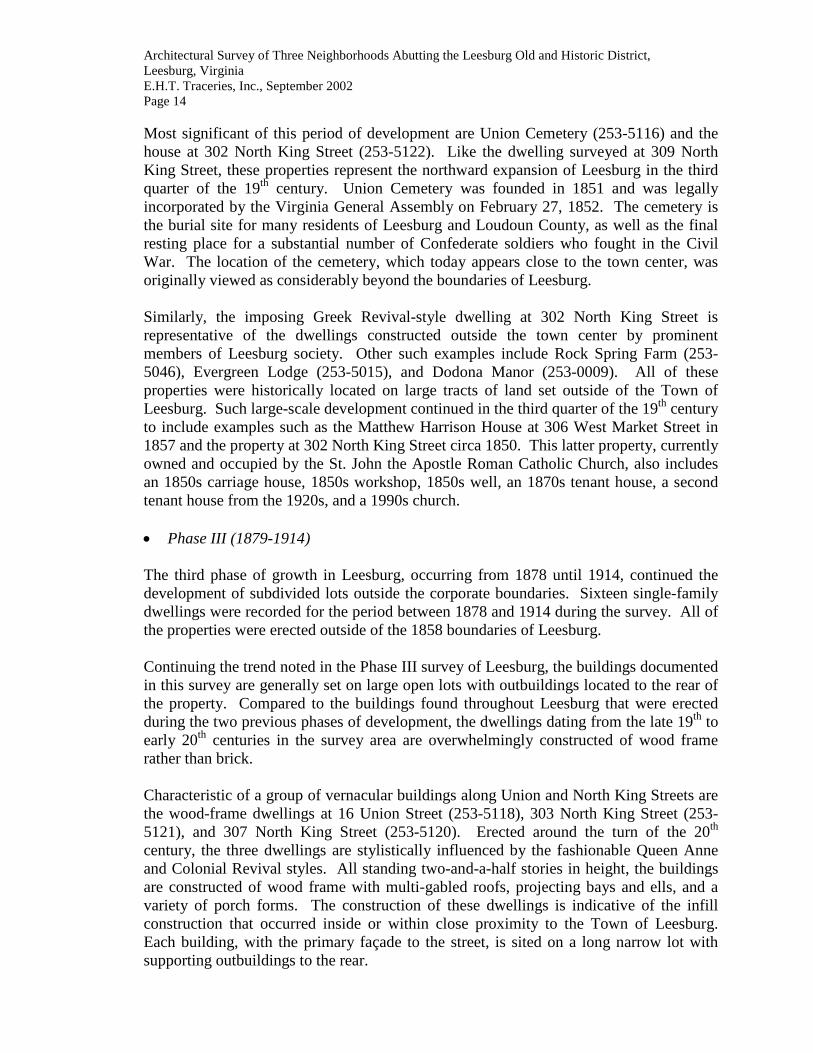
Architectural Survey of Three Neighborhoods Abutting the Leesburg Old and Historic District, Leesburg, Virginia E.H.T. Traceries, Inc., September 2002 Page 21 balusters shelters the first story. A more modest rural interpretation of this form is seen at 404 Edwards Ferry Road (253-5092), which was constructed for Rufus Wren after 1946. Another of the popular building forms of the late 19th and early 20th centuries was the American foursquare, commonly ornamented with Colonial Revival- and Craftsman-style detailing. The term foursquare is often used in reference to an architectural style, yet it means a particular house form – just as bungalows and cabins are forms rather than styles. The two-story, four-room-per-floor house plan without a hall is a much-used concept that refers to the hall/parlor plan of the 18th century. One illustration of the American foursquare exhibiting architectural detailing fashionable in the early part of the 20th century is the dwelling at 302 Edwards Ferry Road (253-5074). This freestanding dwelling has the characteristically distinguished two-story height, hipped or pyramidal roof with pronounced eaves and dormers that light an extra half-story. Additionally, the form features a large wrap-around porch. Generally with a lack of ornate exterior detailing, the overall shape of the American foursquare is a cube, with the main entry opening located off-center as illustrated at 302 Edwards Ferry Road. This Colonial Revival-style dwelling was constructed in 1903 for Josephus Carr, Vice President of Peoples Bank, and remained in the Carr family until 1965. The neighboring Craftsman-style American foursquare house at 304 Edwards Ferry Road (253-5076) was constructed in 1928 for T. Frank Osborn (President of the Peoples Bank).
Figure 5: House, 302 Edwards Ferry Road (253-5074)

Architectural Survey of Three Neighborhoods Abutting the Leesburg Old and Historic District, Leesburg, Virginia E.H.T. Traceries, Inc., September 2002 Page 22 The increasing need for mass-produced housing at a low cost led to the reinvention of the “Cape Cod” form, popularized early in the 18th century. The form is one to one-and-a-half stories in height with a side-gable roof and a single end chimney. Unlike its ancestor, the 20th-century Cape Cod house was pierced with dormers that allowed the upper story to be more fully utilized. The facades were commonly marked with entry porticoes or porches. Like many of the domestic forms of the late 19th century, rear additions and projecting bays on the facade augmented the Cape Cod. The stylistic detailing generally followed the Colonial Revival style, although the form typically lacked the elements characteristic of any particular style. A substantial number of the single-family dwellings included in the survey present the form of a Cape Cod, dressed in a variety of architectural styles and materials. Examples included in the survey are 237 Edwards Ferry Road (253-5067), 306 Edwards Ferry Road (253-5078), 315 Edwards Ferry Road (253-5085), 407 Edwards Ferry Road (253-5097), and 606 Edwards Ferry Road (253-5107).
Figure 6: House, 508 Edwards Ferry Road (253-5104)

Architectural Survey of Three Neighborhoods Abutting the Leesburg Old and Historic District, Leesburg, Virginia E.H.T. Traceries, Inc., September 2002 Page 23 Prominent local architect Claude Honicon1 was responsible for designing a number of modest stone-clad dwellings within the survey area. Unlike the Craftsman-style bungalows Honicon designed in the Phase III survey area, the majority of his dwellings included in this survey have a Cape Cod form with side-gabled roof or square form capped by a shallow hipped roof. Noted examples of Honicon’s work can be seen at 508 West Market Street (253-5126), 247 Edwards Ferry Road (253-5073), 321 Edwards Ferry Road (253-5091), 611 Edwards Ferry Road (253-5112), and 701 Edwards Ferry Road (253-5113).
Figure 7: House, 611 Edwards Ferry Road (253-5112)
Late-20th-century domestic forms in the survey area were more modest in ornamentation and form, although the buildings fronted close to the street with rear yards and supporting outbuildings. Such domestic forms included the one-story cottage, which was augmented by a one-bay-wide front wing and inset porch. This was noted at 318 Edwards Ferry
1 Claude Honicon, a native of Cynthianna, Kentucky, began his career as a builder and architect at age forty-one, after moving to Loudoun County. In the 1930s and early 1940s, Honicon worked in partnership with Ward Loveless. Following the split with Loveless, Honicon continued to work throughout Loudoun County and, at one time, was one of the largest landholders in the county, owning properties in Hillsboro, Waterford, Lovettsville, and Purcellville. Subsequently, he became one of the first large-scale builders in Leesburg. He is credited with building Ellenroyd at Clarks Gap, where his family lived from 1942 until 1959. Owning stone quarries in the Leesburg area, many of the houses attributed to Honicon are constructed of stone from these quarries. He is also noted for some wood-frame buildings. Aside from building houses, Honicon is noted for the construction of four miles of water line, a city parking lot, a motel, gas stations, and an airport, all within Loudoun County. Although a noted builder, Honicon lost most of his money and died impoverished on April 10, 1975 in Leesburg. Telephone conversation with Kitty Rose, May 5, 2000; “Obituaries: Claude Honicon, 84, Builder,” The Loudoun Times-Mirror, (Leesburg, VA: Thursday, April 17, 1975), p. A-20.

Architectural Survey of Three Neighborhoods Abutting the Leesburg Old and Historic District, Leesburg, Virginia E.H.T. Traceries, Inc., September 2002 Page 24 Road (253-5088) and 610 Edwards Ferry Road (253-5111). Larger interpretations of this form, more commonly referred to as ranch houses, are found at 303 Edwards Ferry Road (253-5075), 604 Edwards Ferry Road (253-5127), and 702 Edwards Ferry Road (253-5114). Domestic Outbuildings Typically, the domestic resources constructed in the Town of Leesburg had associated outbuildings (62 were identified), particularly garages and sheds. These structures were typically built of wood frame or brick, depending on the construction material of the main dwelling. The most significant number of outbuildings was constructed during the World War I to World War II (1914-1945) and the New Dominion (1946-present) periods. During the latter period when the automobile played such a significant role in community planning and domestic design, the garage was usually erected simultaneous to the original construction period of the main dwelling. However, in Leesburg, it was noted that freestanding garages were erected at least ten to twenty years after the completion of the associated dwellings. Of the thirty-two garages documented, twenty-six of the examples were historic. However, it should be noted that this does not mean the garages were contemporaneous to the main dwelling, only that the buildings were erected over fifty years ago.
Figure 8: Garage, 10 Wilson Avenue (253-5129)

Architectural Survey of Three Neighborhoods Abutting the Leesburg Old and Historic District, Leesburg, Virginia E.H.T. Traceries, Inc., September 2002 Page 25 The second most common outbuilding identified was the shed, which is actually a catchall term often applied to any storage or unidentified structure. The form is typically one-story and is constructed of wood frame or pre-fabricated metal. Indicative of the popularity of this latter construction material, only eleven of the twenty-three sheds documented were considered to be historic. Other notable outbuildings include a carport, a gazebo, a barbecue, three guesthouses, two carriage houses, a swimming pool, a well and two workshops.
Figure 9: Shed, 310 Edwards Ferry Road (253-5080)
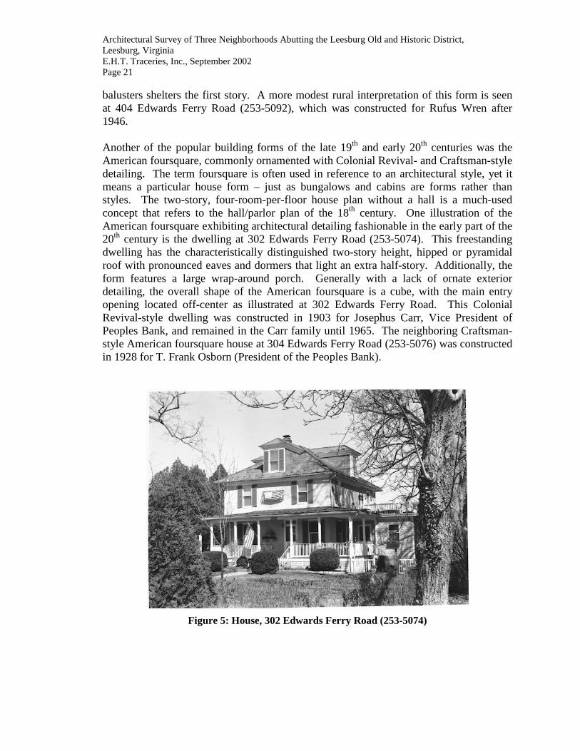
The property at 302 North King Street exhibits an exceptional array of outbuildings. These include an 1850s carriage house, 1850s workshop, 1850s well, 1870s tenant house, 1920s tenant house, and 1990s church. The two-story carriage house is constructed of masonry with a parged foundation and stuccoed walls. The open centered entry, which runs through the building and stands over the main drive to the house, is framed by brick quoins. The building has a side-gabled roof, clad in standing seam metal, with open gable ends crowning the central entry openings. The 1920s carriage house is similarly finished with stucco cladding, a side-gabled roof of standing seam metal, and doublewide sliding garage doors of wood. Also worthy of note is the 1850s workshop. This three-bay-wide structure features a stone foundation and brick nogging that has been exposed on the exterior. An interior-end brick chimney with a corbeled cap rises from the side-gabled roof, which is clad in slate tiles and has a brick cornice. The central entry is flanked by window openings with jack-arched lintels and narrow wood sills. The well to the south of the workshop is constructed of random rubble stone with randomly placed bricks. It is covered by a gable canopy with asphalt shingles, supported by square wood posts and brackets.
Architectural Survey of Three Neighborhoods Abutting the Leesburg Old and Historic District, Leesburg, Virginia E.H.T. Traceries, Inc., September 2002 Page 26
Figure 10: Carriage House, 302 North King Street (253-5122)
Figure 11: Workshop and Well, 302 North King Street (253-5122)
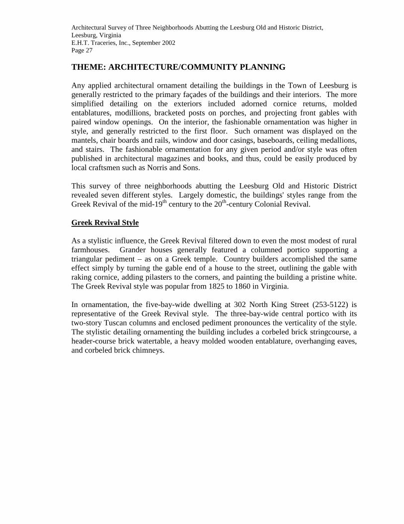
Architectural Survey of Three Neighborhoods Abutting the Leesburg Old and Historic District, Leesburg, Virginia E.H.T. Traceries, Inc., September 2002 Page 27 THEME: ARCHITECTURE/COMMUNITY PLANNING Any applied architectural ornament detailing the buildings in the Town of Leesburg is generally restricted to the primary façades of the buildings and their interiors. The more simplified detailing on the exteriors included adorned cornice returns, molded entablatures, modillions, bracketed posts on porches, and projecting front gables with paired window openings. On the interior, the fashionable ornamentation was higher in style, and generally restricted to the first floor. Such ornament was displayed on the mantels, chair boards and rails, window and door casings, baseboards, ceiling medallions, and stairs. The fashionable ornamentation for any given period and/or style was often published in architectural magazines and books, and thus, could be easily produced by local craftsmen such as Norris and Sons. This survey of three neighborhoods abutting the Leesburg Old and Historic District revealed seven different styles. Largely domestic, the buildings' styles range from the Greek Revival of the mid-19th century to the 20th-century Colonial Revival. Greek Revival Style As a stylistic influence, the Greek Revival filtered down to even the most modest of rural farmhouses. Grander houses generally featured a columned portico supporting a triangular pediment – as on a Greek temple. Country builders accomplished the same effect simply by turning the gable end of a house to the street, outlining the gable with raking cornice, adding pilasters to the corners, and painting the building a pristine white. The Greek Revival style was popular from 1825 to 1860 in Virginia. In ornamentation, the five-bay-wide dwelling at 302 North King Street (253-5122) is representative of the Greek Revival style. The three-bay-wide central portico with its two-story Tuscan columns and enclosed pediment pronounces the verticality of the style. The stylistic detailing ornamenting the building includes a corbeled brick stringcourse, a header-course brick watertable, a heavy molded wooden entablature, overhanging eaves, and corbeled brick chimneys.

Architectural Survey of Three Neighborhoods Abutting the Leesburg Old and Historic District, Leesburg, Virginia E.H.T. Traceries, Inc., September 2002 Page 28
Figure 12: House, 310 Edwards Ferry Road (253-5080)
Gothic Revival Style Predominately modest in detail compared to high-style Gothic Revival archetypes, the resources of Leesburg display the traditional steeply pitched gable and ornately arched openings. Commonly, in communities like Leesburg, the rigid box of the traditional I-house form was distorted by the addition of a single projecting front gable on the primary elevation. This stylistic feature was often added to existing dwellings, or incorporated into the original design. The front gables typically were pierced by narrow window openings with a lancet or pointed arch shape. More vernacular than high style, the Gothic Revival-style house at 310 Edwards Ferry Road (253-5080) is the sole example of this architectural style within the survey area. The I-house form is ornamented with the characteristic steeply pitched front gable, decorative cornice with returns, elongated 2/2 windows on the first story, and a one-story porch lacking an enclosed balustrade. Queen Anne Style This American style, spurred by architectural pattern books, emphasized vertical lines with steep gables, irregular angles, and a variety of decorative materials. The style was favored for freestanding suburban dwellings and rowhouses alike. All were resplendent in patterned shingles, spindles, brackets, and curlicue cutouts; many boasted ample verandas, turrets, and sleeping porches.

Architectural Survey of Three Neighborhoods Abutting the Leesburg Old and Historic District, Leesburg, Virginia E.H.T. Traceries, Inc., September 2002 Page 29 Three Queen Anne-style resources were identified. Although this style traditionally lent itself well to a variety of building forms and uses, only single-family dwellings were recorded. The Queen Anne style was immensely popular in the United States between 1870 and 1910, although it is interesting to note that three properties dressed in the ornate style date from 1900 to 1912. Examples include the houses at 320 Edwards Ferry Road (253-5090), 16 Union Street, N.W. (253-5118), and 303 North King Street (253-5121). The building at 303 North King Street is typical of the style, with its large square form and asymmetrical massing. Constructed circa 1900, the wood-frame dwelling is set on a random rubble stone foundation and clad in German siding. The slightly overhanging gable ends are finished with square-butt and octagonal wood shingles and pierced by ornamental fixed and double-hung windows. The wrap-around porch rises two stories on the north elevation and features turned posts, square balusters, and scroll-sawn brackets. Presenting the I-house form, the dwelling at 16 Union Street was constructed circa 1912 in the Queen Anne style of architecture. The wood-frame building is set on a random rubble stone foundation and features German siding and cornerboards. The side-gabled roof, clad in standing seam metal, features a center gable with square-butt wood shingles and a molded cornice with returns. The façade is dominated by a full-width porch with turned posts, scroll-sawn brackets and square balusters. Colonial Revival Style Following on the heels of America's Centennial celebrations in 1876, the Colonial Revival style emerged in the early 1880s. The style, which borrowed heavily from early American architecture – particularly Georgian and Federal buildings – was largely an outgrowth of a new nationwide pride in the past and a rapidly growing interest in historic preservation. In the early phase, the Colonial Revival style remained the exclusive domain of fashionable architectural firms and was favored for the large residences of wealthy clients. Designs incorporated characteristic features of Colonial buildings, including Palladian windows, gambrel roofs, pedimented porticoes, columns, and Classical detailing such as swags and urns, and crisp white trim. This new building type was larger, however, than its historic counterparts, with details also enlarged and plans laid out on a grandiose scale. As the style spread to more rural areas, it was more conservative in design and scale, and was often applied to modest residences. Within the survey area, forty-two resources were associated with the Colonial Revival style, making it the most prevalent architectural style recorded. Identifying features of the style commonly found include accentuated main entry doors, symmetrically balanced facades, single and paired double-hung sash windows, and side-gable or gambrel roofs. The more urban examples of this style have porches with Tuscan columns, paired window openings, and Palladian windows with diamond-shaped panes.

Architectural Survey of Three Neighborhoods Abutting the Leesburg Old and Historic District, Leesburg, Virginia E.H.T. Traceries, Inc., September 2002 Page 30
Figure 13: House, 248 Edwards Ferry Road (253-5072)
One of the most high-style residential buildings displaying the Colonial Revival style is the two-and-a-half-story house at 248 Edwards Ferry Road (253-5072). Constructed about 1890, the weatherboard-clad wood-frame dwelling is dominated by a full-height front portico. The portico, located on the primary façade, is set within the hipped roof of the house and composed of square Tuscan posts. Single 2/2 double-hung, wood sash dormer windows with hipped roofs pierce the main roof. The symmetrical façade, an element indicative of the style, measures five bays wide with a central entry and 2/2 double-hung, wood sash windows framed by louvered wood shutters. Another example of the Colonial Revival style is the house at 232 Edwards Ferry Road (253-5064), which was constructed circa 1910. This wood-frame dwelling, now clad in stucco and square-butt wood shingles, has a sloping gambrel roof clad in standing seam metal. A stylized fanlight and sidelights ornately frame the main entry, which is flanked by large 6/6 double-hung, wood sash windows with louvered shutters.

Architectural Survey of Three Neighborhoods Abutting the Leesburg Old and Historic District, Leesburg, Virginia E.H.T. Traceries, Inc., September 2002 Page 31
Figure 14: House, 321 Edwards Ferry Road (253-5091)
Modest interpretations of the style are found throughout the survey area, including such examples as 307 North King Street (253-5120), 608 West Market Street (253-5123), 2 Pershing Drive, N.W. (253-5125), and 14 Wilson Avenue, N.W. (253-5131) to name only a few. Colonial Revival-style ornamentation utilized by Claude Honicon in the survey area is illustrated on the modest Cape Cod dwellings at 321 Edwards Ferry Road (253-5091) and 508 Edwards Ferry Road (253-5126). One-story front porches augment these similar dwellings, which are constructed of masonry. The half-hipped roofs on the porches are supported by single Tuscan pilasters and paired Tuscan columns. Paired 6/6 windows set within segmentally arched openings flank the central single entry. Tudor Revival Style Like the Colonial Revival style, the Tudor Revival-style houses of the late 19th and early 20th centuries were derived primarily from English Renaissance buildings of the 16th and 17th centuries. These asymmetrically massed buildings typically featured steeply pitched roofs, one or more intersection gables, decorative – rather than structural – half-timbering and long rows of casement windows. By the early 20th century, the Tudor Revival style was adapted to the middle-class suburban house and eventually became especially popular for the affordable small house of the 1920s and 1930s. Within the survey area a single example of the Tudor Revival style was noted. Located at 247 Edwards Ferry Road (253-5073), this stone-clad dwelling presents the typical steeply pitched side-gabled roof, prominent chimney, multi-light casement windows, and center gable with segmentally arched opening and wrought-iron balcony. The main entry, as was common for this style, is slightly recessed and sheltered by the flat roof of the balcony.
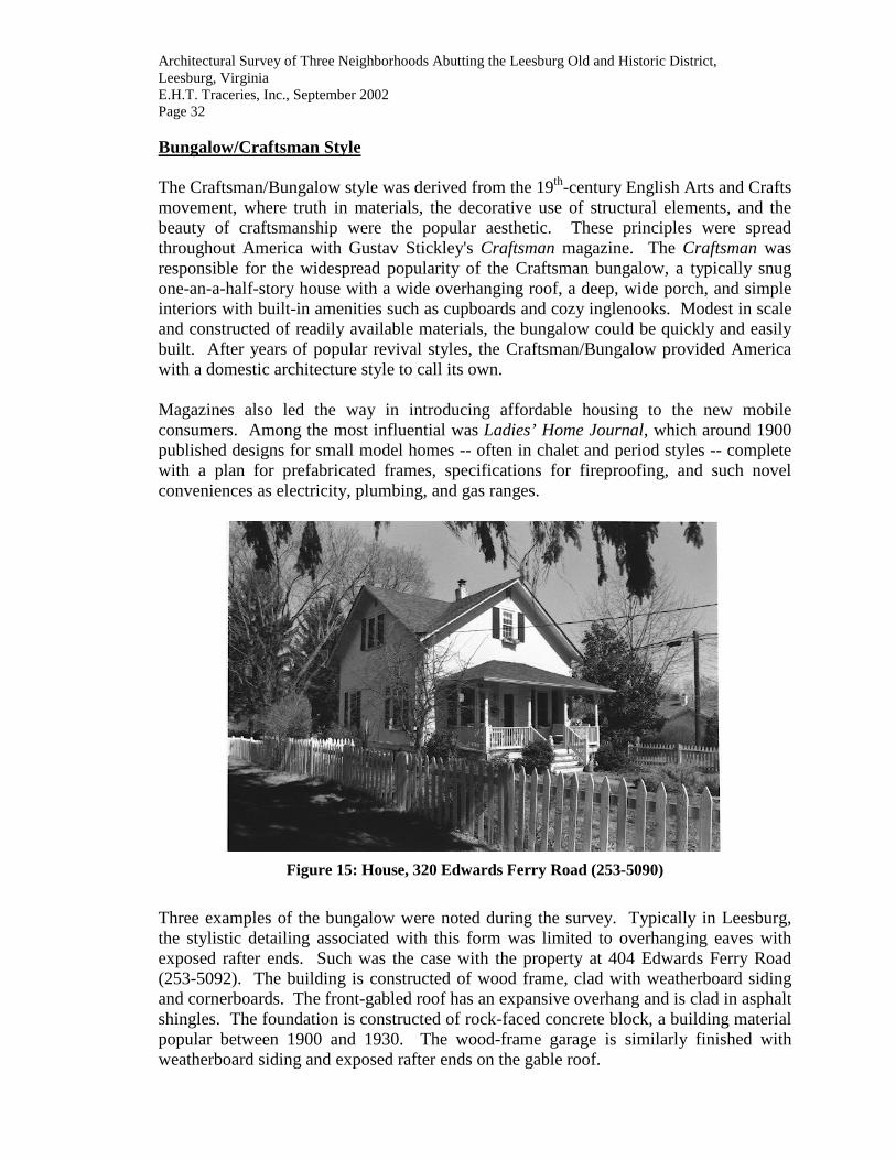
Architectural Survey of Three Neighborhoods Abutting the Leesburg Old and Historic District, Leesburg, Virginia E.H.T. Traceries, Inc., September 2002 Page 32 Bungalow/Craftsman Style The Craftsman/Bungalow style was derived from the 19th-century English Arts and Crafts movement, where truth in materials, the decorative use of structural elements, and the beauty of craftsmanship were the popular aesthetic. These principles were spread throughout America with Gustav Stickley's Craftsman magazine. The Craftsman was responsible for the widespread popularity of the Craftsman bungalow, a typically snug one-an-a-half-story house with a wide overhanging roof, a deep, wide porch, and simple interiors with built-in amenities such as cupboards and cozy inglenooks. Modest in scale and constructed of readily available materials, the bungalow could be quickly and easily built. After years of popular revival styles, the Craftsman/Bungalow provided America with a domestic architecture style to call its own. Magazines also led the way in introducing affordable housing to the new mobile consumers. Among the most influential was Ladies’ Home Journal, which around 1900 published designs for small model homes -- often in chalet and period styles -- complete with a plan for prefabricated frames, specifications for fireproofing, and such novel conveniences as electricity, plumbing, and gas ranges.
Figure 15: House, 320 Edwards Ferry Road (253-5090)
Three examples of the bungalow were noted during the survey. Typically in Leesburg, the stylistic detailing associated with this form was limited to overhanging eaves with exposed rafter ends. Such was the case with the property at 404 Edwards Ferry Road (253-5092). The building is constructed of wood frame, clad with weatherboard siding and cornerboards. The front-gabled roof has an expansive overhang and is clad in asphalt shingles. The foundation is constructed of rock-faced concrete block, a building material popular between 1900 and 1930. The wood-frame garage is similarly finished with weatherboard siding and exposed rafter ends on the gable roof.

Architectural Survey of Three Neighborhoods Abutting the Leesburg Old and Historic District, Leesburg, Virginia E.H.T. Traceries, Inc., September 2002 Page 33 The single-family dwelling at 304 Edwards Ferry Road (253-5076) is an excellent example of the Craftsman style ornamenting the American foursquare form. The 1928 two-and-a-half story dwelling is constructed of brick, laid in stretcher bond. Hipped 6/1 double-hung, wood sash dormer windows pierce the hipped roof, which is clad in standing seam metal and has an overhang eave. Single and paired 6/1 double-hung, wood sash windows with molded surrounds and thin sills pierce the façade. The full-width front porch, covered by a half-hipped roof, has square balusters and tapered square posts set on brick piers. Other Styles The majority of properties in Leesburg, typically the domestic resources, were constructed for a particular function and often were influenced by the shapes, materials, detailing, or other features associated with the architectural styles that were currently in vogue. The survey documented vernacular interpretations of the traditionally high style architectural detailing commonly associated with cities, which often served as laboratories for new styles. As these new fashions spread from the cities to towns and rural communities, the styles were transformed to accommodate smaller resources and varied materials. Often referred to as vernacular or folk housing, the rural buildings incorporated stylistic detailing and popular ornamentation, if only in a diluted state. This resulted in a number of the properties surveyed to be denoted with the architectural description of “other,” a generic term applied by VDHR for vernacular buildings with little or no stylistic ornamentation. This occurred nineteen times in the survey area, with no stylistic label applied to primary resources. Typically, outbuildings were recorded as other because of their vernacular nature. Several resources listed as “Other” did not conform to any style because the original structure had been severely altered, losing or obscuring the original forms and details. THEME: SUBSISTENCE/AGRICULTURE RESOURCE TYPES: Farmsteads, Agricultural Fields, and Animal Facilities The number of farm buildings in the survey area is limited, with just five properties retaining agricultural structures. The more residential nature of the survey area confined the type of agricultural outbuilding to just barns. Barns Generally identified by their relatively large size and distinctive shapes, early-20th-century barns are often large, two-story frame buildings with gambrel roofs and hay hoods. Rows of small window openings providing natural interior lighting can be found at the first story on the long elevations. The interior spaces of the barns are typically arranged to accommodate rows of livestock on the first floor with hay storage above. The large loft, created by the gambrel roof, provides maximum storage area for hay and feed for the animals. Hay barns are often identical in exterior form, but generally do not
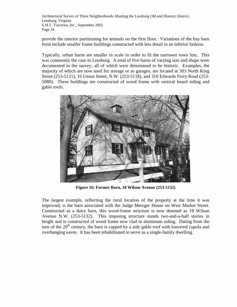
Architectural Survey of Three Neighborhoods Abutting the Leesburg Old and Historic District, Leesburg, Virginia E.H.T. Traceries, Inc., September 2002 Page 34 provide the interior partitioning for animals on the first floor. Variations of the hay barn form include smaller frame buildings constructed with less detail in an inferior fashion. Typically, urban barns are smaller in scale in order to fit the narrower town lots. This was commonly the case in Leesburg. A total of five barns of varying size and shape were documented in the survey, all of which were determined to be historic. Examples, the majority of which are now used for storage or as garages, are located at 303 North King Street (253-5121), 16 Union Street, N.W. (253-5118), and 310 Edwards Ferry Road (253-5080). These buildings are constructed of wood frame with vertical board siding and gable roofs.
Figure 16: Former Barn, 18 Wilson Avenue (253-5132)
The largest example, reflecting the rural location of the property at the time it was improved, is the barn associated with the Judge Metzger House on West Market Street. Constructed as a dairy barn, this wood-frame structure is now denoted as 18 Wilson Avenue N.W. (253-5132). This imposing structure stands two-and-a-half stories in height and is constructed of wood frame now clad in aluminum siding. Dating from the turn of the 20th century, the barn is capped by a side gable roof with louvered cupola and overhanging eaves. It has been rehabilitated to serve as a single-family dwelling.
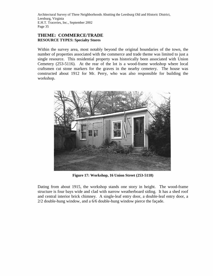
Architectural Survey of Three Neighborhoods Abutting the Leesburg Old and Historic District, Leesburg, Virginia E.H.T. Traceries, Inc., September 2002 Page 35 THEME: COMMERCE/TRADE RESOURCE TYPES: Specialty Stores Within the survey area, most notably beyond the original boundaries of the town, the number of properties associated with the commerce and trade theme was limited to just a single resource. This residential property was historically been associated with Union Cemetery (253-5116). At the rear of the lot is a wood-frame workshop where local craftsmen cut stone markers for the graves in the nearby cemetery. The house was constructed about 1912 for Mr. Perry, who was also responsible for building the workshop.
Figure 17: Workshop, 16 Union Street (253-5118)
Dating from about 1915, the workshop stands one story in height. The wood-frame structure is four bays wide and clad with narrow weatherboard siding. It has a shed roof and central interior brick chimney. A single-leaf entry door, a double-leaf entry door, a 2/2 double-hung window, and a 6/6 double-hung window pierce the façade.

Architectural Survey of Three Neighborhoods Abutting the Leesburg Old and Historic District, Leesburg, Virginia E.H.T. Traceries, Inc., September 2002 Page 36 THEME: EDUCATION RESOURCE TYPES: Schools The survey documented a single property associated with the education theme: The Loudoun County Public Schools Instructional Materials Center at 20 Union Street, N.W. (253-5117).
Figure 18: School, 20 Union Street (253-5117)
This non-historic building was constructed about 1970 to house the Instructional Materials Center (IMC) for Loudoun County Public Schools. The IMC maintains a collection of materials focusing primarily on educational topics, including books, magazines and journals, microfiche, pamphlets and other materials available to the county’s school and library staff. The building is a modern masonry structure, standing one story in height. It measures five bays wide and has a flat roof. The central entry has a double-leaf door with a fixed door to the east. The opening is topped by a two-light transom and sheltered under a flat hood with cut-out brackets. The openings illuminating the building are single and paired one-light windows of metal with rowlock sills.

Architectural Survey of Three Neighborhoods Abutting the Leesburg Old and Historic District, Leesburg, Virginia E.H.T. Traceries, Inc., September 2002 Page 37 THEME: RELIGION RESOURCE TYPES: Places of Worship and Church-related Residences The survey documented three properties related to the theme of religion. This includes the Loudoun Baptist Temple (253-5096), the dwelling at 307 North King Street (253-5120) that was used at one time as a parsonage, and the property at 302 North King Street (253-5122) that is now owned and occupied by St. John the Apostle Roman Catholic Church. This latter property supports the St. John the Apostle Roman Catholic Church (253-0035-0653), which was erected in 1878 at 231 North King Street.
Figure 19: Loudoun Baptist Temple (253-5096)
The Loudoun Baptists Temple at 412 Edwards Ferry Drive was constructed at the intersection of Edwards Ferry Drive and Catoctin Circle in the middle of the 20th century to support the growing residential community in the eastern section of Leesburg. The one-story brick building, ornamented with coursed stone, is three bays wide and five bays deep. It is covered by a front gable roof and topped by a wood-frame steeple with louvered lantern. A one-story office supports the rectangular-shaped church. THEME: FUNERARY RESOURCE TYPES: Cemeteries and Graves A single example of the funerary theme was noted during the survey: Union Cemetery (253-5116). The largest and most prominent cemetery in Leesburg, Union Cemetery was founded in 1851 and legally incorporated by the Virginia General Assembly on February 27, 1852. The large cemetery, with thousands of interments, is the final resting place for many residents of Leesburg and Loudoun County. Additionally, the cemetery was the burial site for a significant number of Confederate soldiers who fought in Loudoun

Architectural Survey of Three Neighborhoods Abutting the Leesburg Old and Historic District, Leesburg, Virginia E.H.T. Traceries, Inc., September 2002 Page 38 County during the Civil War. The earliest located marker dates from February 6, 1854 (Elizabeth Garrison) and the most recent interment was July 30, 2002 (William J. McDonough). A rock-faced concrete block building, constructed in 1908, serves as a non-denominational chapel for the cemetery.
Figure 20: Union Cemetery (253-5116)
Leesburg and Loudoun County families represented in Union Cemetery include Mercer, Birkby, Powell, Grimes, Wallace, Beards, Mason, Harper, Rust, and Aldridge families, to name only a few. Politicians buried here include Charles Fenton Mercer (1778-1858), a member of the U.S. House of Representative from Virginia from 1817 to 1839, and Lewis Nixon (1861-1940) of New York. Nixon, who was born in Leesburg, was a delegate to the Democratic National Convention from New York in 1900, 1904, 1908, 1912, 1920, 1924, and 1932. He designed battleships for the U.S. Navy, was proprietor of shipyards, and a prominent leader of Tammany Hall in 1901-1902. The large cemetery features a substantial number of marked graves, with headstones of marble, limestone, and granite. Several of the graves are marked with large monuments such as obelisks. The more recent graves, predominantly located in the northern section of the property, are marked with headstones and ground plaques. The graves of the Confederate soldiers are demarcated with iron crosses. A number of the Civil War grave markers are dated 1861, noting the soldiers’ participation in the Battle of Ball's Bluff (October 21, 1861).

Architectural Survey of Three Neighborhoods Abutting the Leesburg Old and Historic District, Leesburg, Virginia E.H.T. Traceries, Inc., September 2002 Page 39 RESEARCH DESIGN Objectives The goal of this project was to conduct a survey of approximately seventy architectural resources abutting the 1759 plan area of Leesburg's Old and Historic District in accordance with the Town of Leesburg's Request for Proposal, 2001-2002 CLG Grant Project. The project was intended to: 1) collect additional information and survey previously unidentified or unevaluated properties; 2) synthesize and complete documentation of these properties into a computerized database format; 3) heighten public awareness about historic resources to encourage citizen appreciation of their history; and 4) present recommendations for the nomination of individual properties to the National Register of Historic Places and/or the expansion of the existing historic districts (both local and national). Scope of Work The project was organized into basic tasks:
• complete a survey and evaluation of seventy aboveground architectural resources located just outside of Leesburg's Old and Historic District. All properties within the denoted survey area will be documented;
• record collected data and analyze using DHR-DSS software; • record on Town of Leesburg base maps all survey sites. The survey area will be
outlined on the appropriate USGS quadrangle map to be submitted to DHR;
• generate hard-copy property record survey forms using the DSS system;
• prepare site-plan sketches and photographic documentation to equal or exceed DHR standards;
• prepare a final, illustrated Architectural Survey Report that will conform to the
requirements established in the "Guidelines for Preparing Architectural Survey Reports." The report will include a Description Section that provides an architectural analysis of the resources documented, a detailed inventory, and Historic Context (statement of significance) that addresses the themes of development noted in the survey areas;
• present a public meeting to include interested local government officials and
interested members of local historical associations to discuss goals and survey strategies and generally inform city residents of the survey project. At the completion of the survey, final public presentation will address the findings of the survey to the appropriate local government body; and
• produce two sets of all products for concurrent submission to the Town of
Leesburg and DHR. Eight copies of the final report will be submitted.

Architectural Survey of Three Neighborhoods Abutting the Leesburg Old and Historic District, Leesburg, Virginia E.H.T. Traceries, Inc., September 2002 Page 40 Methodology Approach EHT Traceries, Inc. approached this project as a coordinated effort of experienced professional architectural historians working with the Town of Leesburg and DHR to produce a cost effective survey that meets DHR's high standards and the Town of Leesburg's needs for an updated survey information and a thorough historic context report that augments previous survey efforts. As we have with all our survey work, EHT Traceries, Inc. worked in concert with DHR, the Town of Leesburg staff and officials, and knowledgeable community representatives to produce a survey and documentation project that best fulfills the Town of Leesburg's goal for documentation of its historic resources. This was accomplished by working closely with the Town of Leesburg and its representatives to identify important architectural resources; by taking full advantage of the Data Sharing Software database (DSS) to document and analyze historic properties; by understanding the history and geography to insure that selected cultural resources accurately illustrate the Town’s historic context through the best-preserved and least-altered examples as subsumed under VDHR's eighteen historic context themes; by utilizing years of sound survey experience to ensure an efficient effort; by employing a management methodology that is designed to result in an on-time performance; and by maximizing the potential of an experienced staff. To achieve the desired products, Traceries organized a team with the credentials, skills, and successful experience to do the work. The team was composed of five members: a Project Director/Senior Architectural Historian and four Architectural Historian/Surveyors. The Project Manager/Senior Architectural Historian managed the administration of the survey project, directed the tasks and archival research. She also functioned as the primary architectural historian, preparing the Architectural Survey Report. Additionally, she was responsible for assessing potential landmarks and expansion of the historic districts, both local and national. The Architectural Historian/Surveyors managed the information on the properties recorded – synthesizing, consolidating, undertaking data entry, locating the properties and resources, and updating records as appropriate. They worked together in the field, surveying and documenting all of the resources within the defined boundaries. Basic to the methodology was the determination of criteria for selecting properties to be surveyed using VDHR standards, historic themes, and requirements. This was a team effort that allowed on-site decision-making. A system was established to developed for managing the information on the previously recorded properties, for updating records as necessary, and for identifying and surveying the resources at the reconnaissance level. The recordation of the properties to VDHR standards ensured the successful completion of the contract. Implementing the Survey Design, seventy-one resources were surveyed to a reconnaissance level.

Architectural Survey of Three Neighborhoods Abutting the Leesburg Old and Historic District, Leesburg, Virginia E.H.T. Traceries, Inc., September 2002 Page 41 Each reconnaissance level survey form recorded a single property, including its primary and secondary resources. Each completed form for properties that contained a contributing primary resource included a detailed physical description of that resource as well as a brief description of the secondary resources. It also included a brief evaluation of the property as an entity, placing it within the local historical and architectural context of the Town of Leesburg. Labeled, black-and-white photographs that document the property accompanied all forms. The photographic documentation included a range of two to five views, with an average of four views of the primary resource and a minimum of one photograph per contributing secondary resource or group of secondary resources if located close together. The photographs sufficiently illustrate the architectural character of the primary resource with at least one photograph taken at close range. A simple site plan sketch of the property indicating the relationship between primary and secondary resources was completed for each surveyed property. The site plans were prepared neatly in pencil on graph paper. The site plan sketch included the main road and any significant natural features. Copies of the relevant sections of USGS Quadrangle maps and town base maps were submitted with each group of forms. Work Plan
Implementation of the proposed work will be based on the following task descriptions.
TASK 1: PROJECT ORGANIZATION AND MANAGEMENT 7.0% TASK 2: SURVEY DESIGN 3.0% TASK 3: INITIAL PUBLIC PRESENTATION 3.0% TASK 4: SURVEY 41.0% TASK 5: DSS 15.0% TASK 6: ARCHITECTURAL SURVEY REPORT 17.0% TASK 7: PRODUCTS SUBMISSION 11.0% TASK 8: FINAL PUBLIC PRESENTATION 3.0%
TASK 1: PROJECT ORGANIZATION AND MANAGEMENT Project organization consisted of establishing a work schedule, coordinating with the Town of Leesburg staff, establishing work assignments, arranging for the necessary materials to undertake the work tasks, and maintaining the project schedule. The project director functioned as liaison between the Town of Leesburg, the Department of Historic Resources as necessary, and the project team. Activities included regular monitoring of the project's progress, preparation of the monthly progress reports, and attendance at required progress meetings with the Town of Leesburg.
RESULTS: o Information Meeting o As Required Progress Meetings

Architectural Survey of Three Neighborhoods Abutting the Leesburg Old and Historic District, Leesburg, Virginia E.H.T. Traceries, Inc., September 2002 Page 42 TASK 2: SURVEY DESIGN All existing survey materials contained within the Town of Leesburg files and the DHR archives was reviewed. Other information reviewed included indices, topographic maps, and unpublished survey reports. New materials archived at resource sites in the Town of Leesburg and Loudoun County, as well as at federal resources in Washington, D.C., including the Library of Congress, were also studied.
The Town of Leesburg planning staff was consulted regarding future development projects that may affect historic resources. Documents, including the local comprehensive plan, Virginia Department of Transportation plans, and public utility plans, were reviewed.
RESULTS: o Survey Design TASK 3: INITIAL PUBLIC PRESENTATION During the initial phase of the project, a public meeting will be held for interested local government officials and interested members of local historical associations to discuss goals and survey strategies and generally inform residents of the survey project. Attendees were asked to provide information that might aid the effort.
RESULTS: o Initial public presentation TASK 4: SURVEY Implementation of the survey design was initiated with organization and scheduling based on routing, grouping of properties, weather conditions, and staffing availability. This work was revised and updated throughout the survey effort. Upon completion of a survey schedule, the surveyors began the on-site survey work. The surveyors followed the assigned routes and initiated the reconnaissance-level survey. All work followed DHR standards and properties selected during the on-site survey will meet the published Survey Criteria. E.H.T. Traceries, Inc. was responsible for all on-site survey work that included completion of the survey form, site plans, maps, black-and-white photographs, and color slides. All information collected during this task was filed into individual property file folders. Concurrent with the on-site survey, archival sources were researched. Local, state and federal sources of primary and secondary sources were located and studied. The bibliography was developed. As information was gathered it was synthesized with individual property survey files.
RESULTS: o Survey Schedule and Assignments o On-site survey data on field survey forms
o Site-plan sketches/ photographic documentation o USGS base maps marked and labeled to indicate
location of surveyed properties o In-house research reports o Data entry of archival information

Architectural Survey of Three Neighborhoods Abutting the Leesburg Old and Historic District, Leesburg, Virginia E.H.T. Traceries, Inc., September 2002 Page 43 TASK 5: DSS Information collected on-site survey and recorded on the field forms was entered into the DHR-DSS database as directed by VDHR. Data on each property surveyed was recorded as a single DSS record. As on-site and archival work was completed, the archival data was reviewed. Each DSS property record was edited and expanded by the surveyor responsible for the on-site survey of the property. Each record was completed, reviewed, and revised as appropriate. At appropriate intervals throughout the project, each DSS property record was reviewed for accuracy and consistency. Upon review of the database and following corrections, frequency reports and tabular reports were generated. These reports provided organized data for analysis and incorporation into the Architectural Survey Report. All required reports were generated for inclusion in the Architectural Survey Report.
RESULTS: o Initial Database of DSS Property Records o Expanded Database of DSS Property Records
o Various DSS -generated Analytical Reports o Edited DSS Database
TASK 6: ARCHITECTURAL SURVEY REPORT A final report was prepared to conform to the DHR Guidelines for survey reports. All surveyed properties associated with the relevant historic themes were included in the discussion. Illustrations, including photographs, drawings, maps, tables, charts, or other graphics were prepared. The draft report was revised in accordance with Town of Leesburg’s and VDHR’s comments. The final report was printed to meet the survey product requirements. TASK 7: PRODUCTS SUBMISSION Two sets of survey file envelopes were labeled by hand in pencil and the appropriate documentation filed within each envelope. The labeled photographs and negatives were placed in the appropriate envelopes. The maps, indicating the surveyed properties, were prepared. Additional collected materials were filed. All envelopes were checked for completion. The electronic survey data and reports were transferred into VDHR’s master databases. Two diskettes containing Town of Leesburg's final survey report were prepared for submission. Two loose-leaf originals and eight bound copies of the Architectural Survey Report were prepared. Two sets of hard-copy survey forms (on archival paper), photographs, maps and other materials were prepared for submission to DHR and the Town of Leesburg in labeled DHR survey file envelopes and manila folders, respectively. One set of negatives was prepared for DHR.
RESULTS: o Completed Products TASK 8: FINAL PUBLIC PRESENTATION A final presentation was made to a selected official body in the Town of Leesburg. This presentation summarized the findings and responded to questions and issues. RESULTS: o Final Public Presentation

Architectural Survey of Three Neighborhoods Abutting the Leesburg Old and Historic District, Leesburg, Virginia E.H.T. Traceries, Inc., September 2002 Page 44 Expected Results As presented in Town of Leesburg’s Request for Proposal (RFP) and defined in the contract, it was expected that seventy properties would be surveyed and accessed for inclusion in the local and national historic districts. It was anticipated that the survey would provide a comprehensive survey of architecture and other resources related to the eighteen historic themes established by VDHR. Given the heavy concentration of residential buildings in Town of Leesburg, it was anticipated that the domestic theme would be the best represented; in addition, it was anticipated that the detached single-family dwelling would be the most prevalent type to be surveyed.

Architectural Survey of Three Neighborhoods Abutting the Leesburg Old and Historic District, Leesburg, Virginia E.H.T. Traceries, Inc., September 2002 Page 45 SURVEY FINDINGS TOWN OF LEESBURG DATABASE HOLDINGS The survey and documentation of properties in the Town of Leesburg was completed to the approved standards of the Virginia Department of Historic Resources. The results of the project survey are as follows: Seventy-one (71) properties were recorded to the Reconnaissance Level. Each Reconnaissance Level Survey Form recorded a single property, including primary and secondary resources.
• Seventy-one (71) properties were evaluated as historic and fully surveyed to the reconnaissance level. Each form provides a detailed physical description of the primary resource as well as a brief description of the secondary resources on the property. It includes a brief evaluation of the property, placing it in its local historical and architectural context. Labeled, black-and-white photographs that adequately document the property’s resources accompany each form. Adequate photographic documentation includes several views of the primary resource and a minimum of one photograph per historic secondary resource or group of secondary resources if they are located close together. A simple site plan sketch of the property indicating the relationship between primary and secondary resources is included for each surveyed property. The site plan sketch indicates the main road and any significant natural features such as creeks and rivers. A copy of the relevant section of the county base map is filed with each form. The survey area was marked in pencil on a USGS map.
SUMMARY AND ANALYSIS OF SURVEY FINDINGS Summary The VDHR-Data Sharing Software System (VDHR-DSS) is a computer system developed to meet VDHR's computer needs and desires. VDHR-DSS contains an individual database for the Town of Leesburg, created as part of the Phase I Architectural Survey project in 1998. This most recent survey of three neighborhoods abutting the Old and Historic Leesburg Historic District included the recordation and data-entry of a total of seventy-one records. Of these, sixty were determined to be historic, dating from 1952 or before. Together with the properties identified during the previous survey phases of the Town of Leesburg, the master database contains approximately a total of 682 records.

Architectural Survey of Three Neighborhoods Abutting the Leesburg Old and Historic District, Leesburg, Virginia E.H.T. Traceries, Inc., September 2002 Page 46 TOWN OF LEESBURG SURVEY INVENTORY OF ALL PROPERTIES BY VDHR ID NUMBER
DHR ID#
Year Built Resource Name Resource Type Style
253-5064 1910 House 232 Edwards Ferry Road Garage, Single Dwelling Colonial Revival 253-5065 1946 House, 235 Edwards Ferry Road Garage, Single Dwelling Colonial Revival 253-5066 1880 House, 236 Edwards Ferry Road Garage, Single Dwelling Colonial Revival, Other 253-5067 1950 House, 237 Edwards Ferry Road Single Dwelling Colonial Revival 253-5068 1925 House, 240 Edwards Ferry Road Garage, Single Dwelling Colonial Revival, Other 253-5069 1950 House, 241 Edwards Ferry Road Garage, Shed, Single Dwelling Colonial Revival, Other 253-5070 1905 House, 242 Edwards Ferry Road Single Dwelling Colonial Revival, Other 253-5071 1948 House, 245 Edwards Ferry Road Garage, Single Dwelling Colonial Revival 253-5072 1890 House, 248 Edwards Ferry Road Shed, Single Dwelling Colonial Revival, Other 253-5073 1946 House, 247 Edwards Ferry Road Shed, Single Dwelling Other, Tudor Revival 253-5074 1903 House, 302 Edwards Ferry Road Single Dwelling Colonial Revival 253-5075 1960 House, 303 Edwards Ferry Road Single Dwelling Other
253-5076 1928 House, 304 Edwards Ferry Road Greenhouse, Shed, Single Dwelling
Bungalow/Craftsman, Other
253-5077 1910 House, 307 Edwards Ferry Road Pool, Single Dwelling Colonial Revival, Other 253-5078 1935 House, 306 Edwards Ferry Road Single Dwelling Colonial Revival 253-5079 1939 House, 308 Edwards Ferry Road Shed, Single Dwelling Colonial Revival, Other 253-5080 1875 House, 310 Edwards Ferry Road Barn, Shed, Single Dwelling Gothic Revival, Other 253-5081 1960 House, 311 Edwards Ferry Road Shed, Single Dwelling Other 253-5082 1994 House, 312 Edwards Ferry Road Single Dwelling Other 253-5083 1935 House, 313 Edwards Ferry Road Garage, Shed, Single Dwelling Colonial Revival, Other 253-5084 1880 House, 314 Edwards Ferry Road Garage, Shed, Single Dwelling Other 253-5085 1945 House, 315 Edwards Ferry Road Garage, Shed, Single Dwelling Colonial Revival, Other 253-5086 1870 House, 316 Edwards Ferry Road Barn, Office, Shed, Dwelling Colonial Revival, Other 253-5087 1946 House, 317 Edwards Ferry Road Carport, Single Dwelling Other 253-5088 1963 House, 318 Edwards Ferry Road Garage, Shed, Single Dwelling Colonial Revival, Other 253-5089 1946 House, 319 Edwards Ferry Road Single Dwelling Colonial Revival 253-5090 1910 House, 320 Edwards Ferry Road Garage, Single Dwelling Other, Queen Anne 253-5091 1946 House, 321 Edwards Ferry Road Garage, Single Dwelling Colonial Revival, Other 253-5092 1946 House, 404 Edwards Ferry Road Garage, Single Dwelling Bungalow/Craftsman 253-5093 1946 House, 401 Edwards Ferry Road Single Dwelling Colonial Revival 253-5094 1900 House, 406 A/B Edwards Ferry Road Shed, Single Dwelling Colonial Revival, Other 253-5095 1946 House, 405 Edwards Ferry Road Shed, Single Dwelling Colonial Revival, Other 253-5096 1950 Loudoun Baptist Temple Church, Office Colonial Revival, Other 253-5097 1940 House, 407 Edwards Ferry Road Garage, Single Dwelling Colonial Revival, Other 253-5098 1910 House, 504 Edwards Ferry Road Garage, Shed, Single Dwelling Other 253-5099 1945 House, 501 Edwards Ferry Road Garage, Single Dwelling Colonial Revival, Other 253-5100 1946 House, 506 Edwards Ferry Road Single Dwelling Colonial Revival 253-5101 1946 House, 503 Edwards Ferry Road Garage, Single Dwelling Colonial Revival, Other 253-5102 1946 House, 505 Edwards Ferry Road Shed, Single Dwelling Colonial Revival, Other

Architectural Survey of Three Neighborhoods Abutting the Leesburg Old and Historic District, Leesburg, Virginia E.H.T. Traceries, Inc., September 2002 Page 47 253-5103 1955 House, 507 Edwards Ferry Road Garage, Single Dwelling Colonial Revival, Other 253-5104 1936 House, 508 Edwards Ferry Road Single Dwelling Colonial Revival 253-5105 1930 Shed, 509 Edwards Ferry Road Shed, Single Dwelling Other 253-5106 1958 House, 601 Edwards Ferry Road Garage, Single Dwelling Other 253-5107 1946 House, 606 Edwards Ferry Road Garage, Single Dwelling Colonial Revival, Other 253-5108 1935 House, 605 Edwards Ferry Road Single Dwelling Colonial Revival 253-5109 1954 House, 608 Edwards Ferry Road Single Dwelling Other 253-5110 1950 House, 609 Edwards Ferry Road Garage, Single Dwelling Other 253-5111 1955 House, 610 Edwards Ferry Road Single Dwelling Colonial Revival 253-5112 1950 House, 611 Edwards Ferry Road Garage, Single Dwelling Colonial Revival, Other 253-5113 1953 House, 701 Edwards Ferry Road Garage, Single Dwelling Colonial Revival, Other 253-5114 1960 House, 702 Edwards Ferry Road Shed, Single Dwelling Other 253-5115 1950 House, 707 Edwards Ferry Road Garage, Single Dwelling Other 253-5116 1851 Union Cemetery Cemetery, Chapel Colonial Revival
253-5117 1970 Loudoun County Public Schools Instructional Materials Center , School, 20 Union Street, NW
School Other
253-5118 1912 House, 16 Union Street, NW Barbecue Pit, Barn, Shed, Single Dwelling, Workshop Other, Queen Anne
253-5119 1850 House, 309 King Street, North Single Dwelling Other 253-5120 1897 House, 307 King Street, North Garage, Single Dwelling Colonial Revival, Other 253-5121 1900 House, 303 King Street, North Barn, Single Dwelling Other, Queen Anne
253-5122 1850 House, 302 King Street, North , St. John the Apostle Roman Catholic Church
Carriage House, Church, Single Dwelling, Tenant House, Well, Workshop
Greek Revival, Other
253-5123 1930 House, 608 Market Street, West Single Dwelling Colonial Revival 253-5124 1940 House, 604 Market Street, West Single Dwelling Other
253-5125 1940 House, 2 Pershing Drive, NW Gazebo, Guest House, Single Dwelling Colonial Revival, Other
253-5126 1935 House, 508 Market Street, West Garage, Single Dwelling Colonial Revival, Other 253-5127 1920 House, 504 Market Street, West Single Dwelling Colonial Revival 253-5128 1920 House, 8 Wilson Avenue, NW Garage, Single Dwelling Other 253-5129 1910 House, 10 Wilson Avenue, NW Garage, Single Dwelling Other 253-5130 1910 House, 12 Wilson Avenue, NW Garage, Single Dwelling Other 253-5131 1925 House, 14 Wilson Avenue, NW Garage, Single Dwelling Colonial Revival, Other 253-5132 1910 Barn, 18 Wilson Avenue, NW Barn, Garage Other
253-5133 1920 House, 602 Edwards Ferry Road Garage, Single Dwelling Bungalow/Craftsman, Other
253-5134 2000 House, 104 Catoctin Circle, NE Shed, Single Dwelling Colonial Revival, Other

Architectural Survey of Three Neighborhoods Abutting the Leesburg Old and Historic District, Leesburg, Virginia E.H.T. Traceries, Inc., September 2002 Page 48 Analysis of Survey Findings Statistical information was derived from the survey findings by producing computer-generated reports. These reports are designed to yield specific kinds of information for the appropriate analysis of survey findings. Some of the information entered into the database is factual, being based upon quantitative analysis; other information is valuative, and is based upon Traceries' understanding and evaluation of architectural and historical data collected during the survey. The computer-generated reports represent both factual and valuative assessments, and provide statistics on important trends and aspects of the built environment of the Town of Leesburg. The following analysis was prepared by architectural historians at Traceries and is based upon a professional understanding of the historic properties and resources surveyed, taking into consideration the needs and requirements of the Town of Leesburg and VDHR. • Identification of Properties Each record in the computer represents a property, that is a location defined by a perimeter measurement, such as a lot or parcel of land or a determined environmental setting. Seventy-one properties were identified and surveyed during the course of this project. All properties within the defined survey boundaries, regardless of age, were documented. These properties were documented in two ways: first, by using the Sanborn Fire Insurance Maps of Leesburg, which indicate the sites of resources (i.e. the footprint of a building or structure); and second, through visual identification of primary resources and all associated outbuildings. Categorization of Properties
Each surveyed property is categorized by property type. This categorization reflects the type of resource that is considered to be the primary resource and the source of the property’s historicity. The five property categories are as follows: building, structure, site, and object. The definitions used are included in National Register Bulletin 15: How to Apply the National Register Criteria for Evaluation as follows:
Building: A building, such as a house, barn, church, hotel, or similar construction, is created to shelter any form of human activity. "Building" may also refer to a historically, functionally related unit, such as a courthouse and jail or a house and barn.
District A district possesses a significant concentration,
linkage, or continuity of sites, buildings, structures, or objects united historically or aesthetically by plan or physical development.

Architectural Survey of Three Neighborhoods Abutting the Leesburg Old and Historic District, Leesburg, Virginia E.H.T. Traceries, Inc., September 2002 Page 49
Site A site is the location of a significant event, a prehistoric or historic occupation or activity, or a building or structure, whether standing, ruined, or vanished, when the location itself possesses historic, cultural, or archeological value regardless of the value of any existing structure.
Structure The term "structure" is used to distinguish from
buildings those functional constructions made usually for purposes other than creating human shelter.
Object The term “object” is used to distinguish between
buildings and structures those constructions that are primarily artistic in nature or are relatively small in scale and simply constructed. Although it may be, by nature and design, movable, it is associated with a specific setting or environment, such as statuary in a designed landscape.
In Virginia, it is anticipated that a property will include at least one resource, usually considered its primary resource. The historic character of that resource is usually the basis upon which the determination of the property’s overall historic or non-historic status is made. The proper categorization of a property is dependent on the proper identification of the primary resource. For example, a property that includes a large residence built in the 1870s and several outbuildings from the same period would be categorized as a “BUILDING.” Another property that includes a large residence built in 1995 near the foundation of an 18th century farmhouse would gain its historic status from the archeological potential of the site that is composed of the foundation and its environs, not from the no longer extant original building nor from the new house, therefore this property would be categorized a “SITE.”
TOWN OF LEESBURG SURVEY:
PROPERTY CATEGORIZATION
TOTAL NUMBER OF PROPERTIES
Buildings 71
Districts 0
Objects 0
Sites 0
Structures 0
TOTAL CATEGORIZED PROPERTIES
71

Architectural Survey of Three Neighborhoods Abutting the Leesburg Old and Historic District, Leesburg, Virginia E.H.T. Traceries, Inc., September 2002 Page 50 • Determination of Historic Status The identification of properties and their categorization was followed by the determination of a historic status for the property. For this survey, historic was defined as possessing the capacity to convey reliable historic information about the physical and cultural development of Town of Leesburg. It was not interpreted as a measure of the level of significance of that information. Properties were considered HISTORIC if:
• the primary resource was fifty years of age or more; or
• the resource possessed the capacity to convey reliable historic information about the physical and cultural development of the Town of Leesburg.
Properties were determined to be NON-HISTORIC if:
• the primary resource was less than fifty years of age; • no primary resource was visually evident; or
• the primary resource was altered to a level that any historic
integrity it might have possessed was significantly destroyed or obscured.
TOWN OF LEESBURG SURVEY: PROPERTY CATEGORIES
TOTAL HISTORIC
Buildings 71 total 59 historic
Districts 0 0
Objects 0 0
Sites 0 0
Structures 0 0
TOTAL CATEGORIZED PROPERTIES 71 total 59 historic
A total of twelve of the properties recorded during the survey effort were labeled with a post-1952 construction date, thus these resources are not yet fifty years old. However, the primary resources convey historic information about the physical and cultural development of the Town of Leesburg.

Architectural Survey of Three Neighborhoods Abutting the Leesburg Old and Historic District, Leesburg, Virginia E.H.T. Traceries, Inc., September 2002 Page 51 Primary Resources For the seventy-one properties included in the database, six different primary resource types were identified throughout the survey area. The following report lists the number of each identified resource type recorded as the primary resource:
TOWN OF LEESBURG SURVEY: PRIMARY RESOURCE TYPE CONTAINED BY CONTRIBUTING PROPERTIES
NUMBER OF PRIMARY
RESOURCES RECORDED
Barn 1
Cemetery 1
Church 1
School 1
Sheds 1
Single Dwelling 66
Total 71
• Identification and Count of Resource Sub-Types [WUZITS] For each property surveyed in the Town of Leesburg, a complete list of the resources associated with the property was compiled. In each case, the primary resource was surveyed and documented; the other historic resources were counted and recorded in a counter field and then described in a secondary resources notes field. Each property count not only includes a count of the resources by general type, but a determination and count of the specific resource sub-type. These resource sub-types, classified as "wuzits" in the database, refer to the original purpose for which the resource was constructed and range from single-family dwellings to cemeteries. For the seventy-one properties surveyed, seventeen "wuzits" were identified. A complete list in alphabetical order of the type of "WUZITS" identified and the number of each wuzit counted in the course of this survey was compiled.
TOWN OF LEESBURG SURVEY: RESOURCE
SUB-TYPE
NUMBER FOUND ON
ALL PROPERTIES
NUMBER FOUND TO BE
HISTORIC
Barbecue Pit 1 0
Barn 5 5
Carport 1 0
Carriage House 2 2
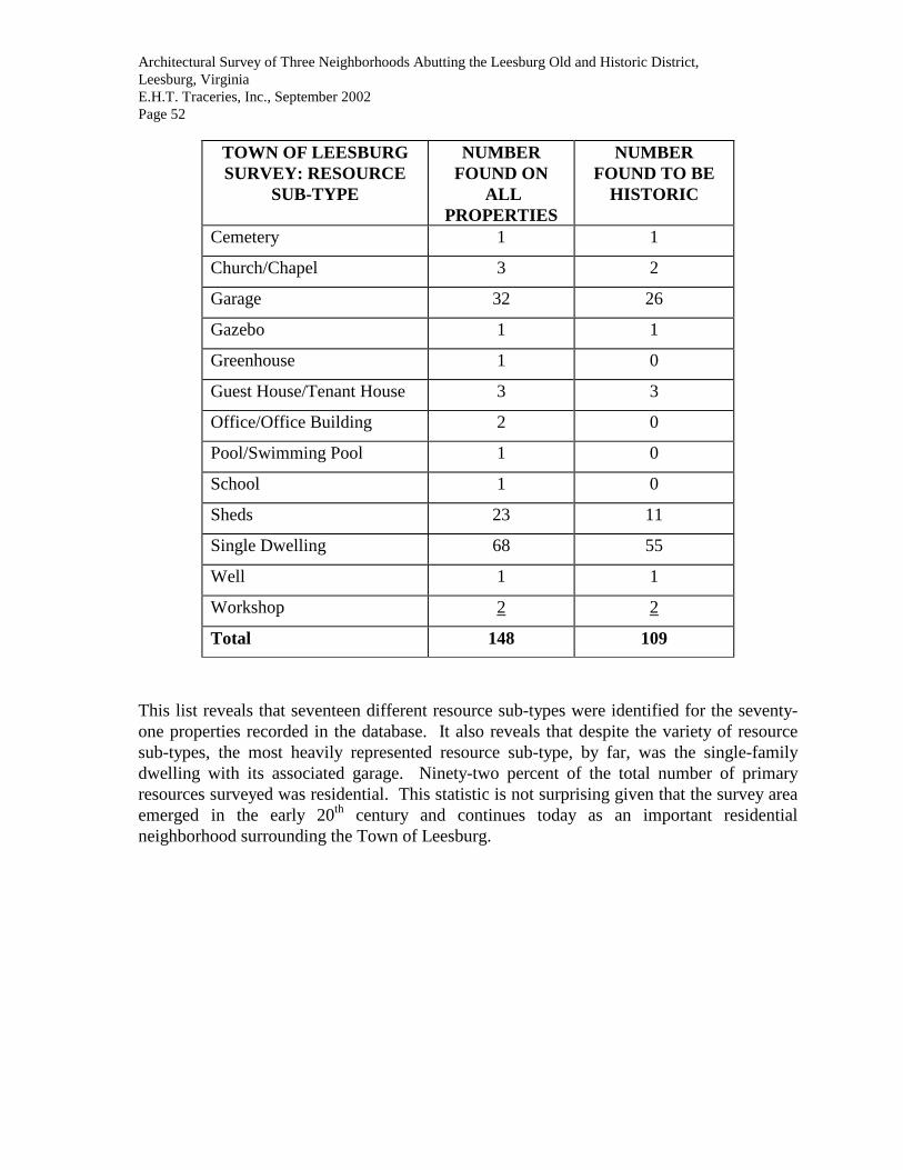
Architectural Survey of Three Neighborhoods Abutting the Leesburg Old and Historic District, Leesburg, Virginia E.H.T. Traceries, Inc., September 2002 Page 52
TOWN OF LEESBURG SURVEY: RESOURCE
SUB-TYPE
NUMBER FOUND ON
ALL PROPERTIES
NUMBER FOUND TO BE
HISTORIC
Cemetery 1 1
Church/Chapel 3 2
Garage 32 26
Gazebo 1 1
Greenhouse 1 0
Guest House/Tenant House 3 3
Office/Office Building 2 0
Pool/Swimming Pool 1 0
School 1 0
Sheds 23 11
Single Dwelling 68 55
Well 1 1
Workshop 2 2
Total 148 109
This list reveals that seventeen different resource sub-types were identified for the seventy-one properties recorded in the database. It also reveals that despite the variety of resource sub-types, the most heavily represented resource sub-type, by far, was the single-family dwelling with its associated garage. Ninety-two percent of the total number of primary resources surveyed was residential. This statistic is not surprising given that the survey area emerged in the early 20th century and continues today as an important residential neighborhood surrounding the Town of Leesburg.

Architectural Survey of Three Neighborhoods Abutting the Leesburg Old and Historic District, Leesburg, Virginia E.H.T. Traceries, Inc., September 2002 Page 53 • Condition of Primary Resource
CONDITION NUMBER RECORDED
GOOD-EXCELLENT
3
GOOD 63
GOOD-FAIR 4
REMODELED 1
• Architectural Style
ARCHITECTURAL STYLE
NUMBER RECORDED
BUNGALOW/CRAFTSMAN 3
COLONIAL REVIVAL 42
GOTHIC REVIVAL 1
GREEK REVIVAL 1
OTHER 19
QUEEN ANNE 3
TUDOR REVIVAL 1
• Source of Date
SOURCE OF DATE NUMBER RECORDED
MAPS 1
ORAL/SITE VISIT 2
OWNER 3
OWNER/SITE VISIT 15
SITE VISIT 42
SITE VISIT/WRITTEN 2
SITE VISIT/MAP 5
WRITTEN DATA 1
*Sally Reed Rich provided valuable documentation that assisted in determining the construction dates of several properties.

Architectural Survey of Three Neighborhoods Abutting the Leesburg Old and Historic District, Leesburg, Virginia E.H.T. Traceries, Inc., September 2002 Page 54 • VDHR Historic Themes and Period Contexts VDHR has defined eighteen cultural themes for Virginia's cultural history from prehistoric times to the present. Although a property may relate to one or more of the defined themes, only the most relevant themes are indicated in the database. The following list shows the number of historic properties within the current boundaries of the Town of Leesburg that are primarily associated with each of the historic context themes identified in the survey.
TOWN OF LEESBURG SURVEY: VDHR THEMES
NUMBER OF ASSOCIATED PROPERTIES
Architecture/Community Planning 71
Commerce/Trade 1
Domestic 67
Education 1
Ethnicity/Immigration 0
Funerary 1
Government/Law/Political 0
Health Care/Medicine 0
Industry/Processing/Extraction 0
Landscape 0
Military/Defense 0
Recreation/Arts 0
Religion 3
Settlement Patterns 0
Social 0
Subsistence/Agriculture 5
Technology/Engineering 0
Transportation/Communication 0

Architectural Survey of Three Neighborhoods Abutting the Leesburg Old and Historic District, Leesburg, Virginia E.H.T. Traceries, Inc., September 2002 Page 55 SURVEY RECOMMENDATIONS A. Recommendations for Further Study • Properties to be Surveyed at the Intensive Level The following properties were included in this survey at a reconnaissance level; however, the architectural and/or historical significance of the primary resource warrants intensive level survey as these properties may be individually eligible for the National Register of Historic Places.
1. House, 248 Edwards Ferry Road (253-5072) 2. House, 307 Edwards Ferry Road (253-5077) 3. Union Cemetery (253-5116) 4. House, 302 West Market Street (253-5122)
B. Evaluation/Recommendations for Designation • Standards for Evaluation The properties identified in the Architectural Survey of Three Neighborhoods Abutting the Town of Leesburg have been evaluated on a preliminary basis for their historic significance at the local, state, and national levels. As stated in the Secretary of the Interior's Standards for Evaluation, evaluation is the process of determining whether identified properties meet defined criteria of significance and whether they should, therefore, be included in an inventory of historic properties determined to meet the established criteria. In association with the Secretary of the Interior's Standards for Evaluation is the Secretary of the Interior's Guidelines for Evaluation. These guidelines describe the principles and process for evaluating the significance of the identified historic properties. In evaluating the historic resources of Leesburg, both the Standards and Guidelines for Evaluation were consulted. As a first step, the guidelines suggest that criteria used to develop an inventory of historic properties should be coordinated with the National Register of Historic Places. In the case of Leesburg, the evaluation process was conducted using the National Register of Historic Places criteria and the Virginia Landmarks Register criteria. The National Register of Historic Places is the official national list of recognized properties, which is maintained and expanded by the National Park Service on behalf of the Secretary of the Interior. The Virginia Landmarks Register criteria, established in 1966, are coordinated with those established for the National Register.
Architectural Survey of Three Neighborhoods Abutting the Leesburg Old and Historic District, Leesburg, Virginia E.H.T. Traceries, Inc., September 2002 Page 56 The National Register of Historic Places Criteria states:
The quality of significance in American history, architecture, archeology, and culture is present in districts, sites, buildings, and objects that possess integrity of location, design, setting, materials, workmanship, feeling, and association, and:
A. that are associated with events that have made a significant
contribution to the broad patterns of our history; or
B. that are associated with the lives of persons significant in our past; or
C. that embodies the distinctive characteristics of a type, period,
or method of construction or that represents the work of a master, or that possesses high artistic values, or that represents a significant and distinguishable entity whose components may lack individual distinction; or
D. that have yielded, or may be likely to yield, information
important in prehistory or history. Similarly, the Virginia Landmarks Register criteria are set forth in the legislation as follows:
No structure or site shall be deemed historic one unless it has been prominently identified with, or best represents, some major aspect of the cultural, political, economic, military, or social history of the State or nation, or has had a relationship with the life of an historic personage or event representing some major aspect of, or ideals related to, the history of the State or nation. In the case of structures which are to be so designated, they shall embody the principal or unique features of an architectural style or demonstrate the style of a period of our history or method of construction, or serve as an illustration of the work of a master builder, designer or architect whose genius influenced the period in which he worked or has significance in current times. In order for a site to qualify as an archaeological site, it shall be an area from which it is reasonable to expect that artifacts, materials, and other specimens may be found which give insight to an understanding of aboriginal man or the Colonial and early history and architecture of the state or nation.

Architectural Survey of Three Neighborhoods Abutting the Leesburg Old and Historic District, Leesburg, Virginia E.H.T. Traceries, Inc., September 2002 Page 57 A second consideration cited by the guidelines suggests that the established criteria should be applied within particular historic contexts. In the case of Leesburg, the criteria were examined to determine how they might apply to properties within the given context. The historic contexts are synonymous with the eighteen historic themes developed by the VDHR and listed as follows:
Domestic Theme: This theme relates broadly to the human need for shelter, a home place, and community dwellings.
Subsistence/Agriculture Theme: This theme most broadly seeks explanations of the different strategies that cultures develop to procure, process, and store food.
Government/Law/Political Theme: This theme relates primarily to the enactment and administration of laws by which a nation, state, or other political jurisdiction is governed; and activities related to politics and government.
Health Care/Medicine Theme: This theme refers to the care of sick, elderly and the disabled, and the promotion of health and hygiene.
Education Theme: This theme relates to the process of conveying or acquiring knowledge or skills through systematic instruction, training, or study, whether through public or private efforts. Military/Defense Theme: This theme relates to the system of defending the territory and sovereignty of a people and encompasses all military activities, battles, strategic locations, and events important in military history.
Religion Theme: This theme concerns the organized system of beliefs, practices, and traditions regarding the worldview of various cultures and the material manifestation of spiritual beliefs.
Social Theme: This theme relates to social activities and institutions, the activities of charitable, fraternal, or other community organizations and places associated with broad social movements.
Recreation and the Arts Theme: This theme relates to the arts and cultural activities and institutions related to leisure time and recreation.
Transportation/Communication Theme: This theme relates to the process and technology of conveying passengers, materials, and information.
Commerce/Trade Theme: This theme relates to the process of trading goods, services, and commodities.

Architectural Survey of Three Neighborhoods Abutting the Leesburg Old and Historic District, Leesburg, Virginia E.H.T. Traceries, Inc., September 2002 Page 58
Industry/Processing/Extraction Theme: This theme explores the technology and process of managing materials, labor, and equipment to produce goods and services.
Landscape Theme: This theme explores the historic, cultural, scenic, visual and design qualities of cultural landscapes, emphasizing the reciprocal relationships affecting the natural and the human-built environment.
Funerary Theme: This theme concerns the investigation of gravesites for demographic data to study population, composition, health, and mortality within prehistoric and historic societies.
Ethnicity/Immigration Theme: This theme explores the material manifestations of ethnic diversity and the movement and interaction of people of different ethnic heritages through time and space in Virginia.
Settlement Patterns Theme: Studies related to this theme involve the analysis of different strategies available for the utilization of an area in response to subsistence, demographic, socio-political, and religious aspects of a cultural system.
Architecture/Landscape Architecture/Community Planning Theme: This theme explores the design values and practical arts of planning, designing, arranging, constructing and developing buildings, structures, landscapes, towns and cities for human use and enjoyment. Technology/Engineering Theme: While the technological aspects of a culture form the primary basis of interpretation of all themes, this theme relates primarily to the utilization of and evolutionary changes in material culture as a society adapts to the physical, biological, and cultural environment.
After determining how the criteria applies, the Secretary of Interior's Guidelines for Evaluation suggests that the integrity of a property should be evaluated. In evaluating the integrity, factors such as structural problems, deterioration, and abandonment should be considered if they have affected the significance of the property. In surveying the properties of Leesburg, the integrity of the resource was evaluated using the seven aspects as defined in National Register Bulletin 15: How to Apply the National Register Criteria for Evaluation. The aspects include location, design, setting, materials, workmanship, feeling, and association. The seventh aspect, association, was not always evaluated while conducting on-site survey work, and often requires further archival research. Based upon the state and national guidelines and criteria, all of the properties in Leesburg were evaluated for potential nomination to the Virginia Landmarks Register and the National Register of Historic Places.
Architectural Survey of Three Neighborhoods Abutting the Leesburg Old and Historic District, Leesburg, Virginia E.H.T. Traceries, Inc., September 2002 Page 59 • Recommendations for Designation to the National Register of Historic Places: Expand Boundaries of the Leesburg National Register Historic District: The Leesburg National Register Historic District was designated to the Virginia Landmarks Register in 1969 and the National Register of Historic Places in 1970. The historic district was amended and expanded in 2001. The period of significance for the national historic district was amended to 1757 through 1950 and continues to support the areas of significance (architecture and community planning/development). The boundaries of the National Register historic district are essentially based upon the boundaries of the locally designated Leesburg Old and Historic District. The expanded boundaries of the Leesburg National Register Historic District encompass properties that reflect all six of the identified phases of development in Leesburg. The properties included in this most recent survey primarily reflect the development of Leesburg from 1920 to 1950, which is the fourth phase of development. Therefore, these properties, having been comprehensively surveyed and documented, should be included within the boundaries of the local Leesburg Old and Historic District and the Leesburg National Register Historic District. • Recommendations for the Leesburg Old and Historic District: Expand Boundaries of the Leesburg Old and Historic District: The Leesburg Old and Historic District is the local historic district, which was designated in 1963 and expanded in 1990 by the Leesburg Town Council. The period of significance for the local historic district has been determined to extend from 1758 to 1950. Once the national historic district boundaries have been examined, as is recommended above, the boundaries for the locally designated historic district should be re-evaluated and expanded/decreased where appropriate to include the contributing properties documented as part of this survey.

Architectural Survey of Three Neighborhoods Abutting the Leesburg Old and Historic District, Leesburg, Virginia E.H.T. Traceries, Inc., September 2002 Page 60 BIBLIOGRAPHY Books and Other Published Materials Bennett’s Small House Catalog, 1920. New York: Dover Publications, Inc., 1993. Originally
printed as Bennett Homes: Better-built Ready Cut. Catalog 18. North Tonawanda, NY: Ray H. Bennett Lumber Co., Inc., 1920.
Carley, Rachel. The Visual Dictionary of American Domestic Architecture. New York, NY:
Henry Holt and Company, 1994. Clark, Clifford Edward Jr., The American Family Home, 1800-1960. Chapel Hill, NC: The
University of North Carolina Press, 1986. Cocke, Charles Francis. Parish Lines Diocese of Virginia. Richmond, VA: The Virginia State
Library, 1967. Downing, A.J. Victorian Cottage Residences. 1873. Reprint, New York: Dover Publications,
Inc., 1981. 500 Small Houses of the Twenties. Compiled by Henry Atterbury Smith. New York: Dover
Publications, Inc., 1990. Originally published as The Books of a Thousand Homes: Volume I containing 500 plans of Moderate Cost 3 to 8 Room Houses: Working Drawings and Specifications Available. New York: Home Owners Service Institute, 1923.
GAI Consultants – VA. “Architectural Survey of the Leesburg Old and Historic District-Phase
II.” August 1999. HaAR. “Leesburg Historic District: A Survey of the Nicholas Minor Section.” August 1998. Halsted, Byron David, editor. Barns, Sheds and Outbuildings. Brattleboro, Vermont: Stephen
Greene Press, 1977, 170-176. Reprint of the 1881 edition published under title: Barn Plans and Outbuildings: Placement, Design and Construction. New York: Orange Judd Company, 1881.
Hartzog, Lader and Richards, “Town of Leesburg, Virginia: Architectural Historic Inventory
Survey,” 1975. Located at the Planning Department. Houses by Mail: A Guide to Houses from Sears, Roebuck and Company. Introduction by
Katherine Cole Stevenson and H. Ward Jandl. Washington, D.C.: The Preservation Press, 1986.
Loth, Calder, ed., The Virginia Landmarks Register, Charlottesville, Virginia, The University
Press of Virginia, 1999.

Architectural Survey of Three Neighborhoods Abutting the Leesburg Old and Historic District, Leesburg, Virginia E.H.T. Traceries, Inc., September 2002 Page 61 McAlester, Virginia and Lee McAlester. A Field Guide to American Houses. New York:
Alfred A. Knopf, Inc., 1984. Morrison, Hugh. Early American Architecture: From the First Colonial Settlements to the
National Period. New York: Oxford University Press, 1952. Phillips, John T., II. The Historian’s Guide to Loudoun County, Virginia. Vol. 1. Colonial
Laws of Virginia and County Court Orders, 1757-1766. Leesburg: Goose Creek Productions, 1996.
Scheel, Eugene. The Guide to Loudoun: A Survey of the Architecture and History of a Virginia
County. Leesburg, Potomac Press, 1975. Sears, Roebuck Catalog of Houses, 1926. New York: Dover Publications and The Athenaeum
of Philadelphia, 1991. Originally published as Honor Bilt Modern Homes. Chicago and Philadelphia: Sears, Roebuck and Co., 1926.
Sears, Roebuck Homebuilder’s Catalog: The Complete Illustrated 1910 Edition. New York:
Dover Publications, Inc., 1990. Originally printed as Our Special Catalog for Home Builders. Chicago: Sears, Roebuck and Co., n.d. (1910).
Steadman, Melvin Lee. A Walk Around Leesburg. Loudoun Museum and Information Center. Williams, Harrison, Legends of Loudoun: An Account of the History and Homes of a Border
County of Virginia’s Northern Neck, Richmond, VA: Garrett and Massie, Incorporated, 1938.
Journal Articles Cotton, J. Randall. "Return to Concrete Block Houses.” In Old House Journal Vol. XXIII, No.
2, (March/April 1995), pp. 33-39. Hanchett, Thomas W. "The Four Square House Type in the United States.” In Perspectives in
Vernacular Architecture, edited by Camille Wells, pp. 51-53. Columbia, Missouri: The University of Missouri Press for the Vernacular Architecture Forum, 1987.
McIntosh, Burr. “A Group of Virginia’s Colonial Homes.” Town and Country 61 (7 July 1906),
pp. 10-13. Massey, James C. and Shirley Maxwell. "The All-American Family House: A Look at the
Foursquare.” In Old-House Journal Vol. XXIII, No. 6 (November/December 1995): p. 31.

Architectural Survey of Three Neighborhoods Abutting the Leesburg Old and Historic District, Leesburg, Virginia E.H.T. Traceries, Inc., September 2002 Page 62 Massey, James C. and Shirley Maxwell. "A Nation in Bungalove.” In Old House Journal Vol.
XXIV, No. 2 (March/April 1996): pp. 35-36. “Obituaries: Claude Honicon, 84, Builder,” The Loudoun Times-Mirror, (Leesburg, VA: Thursday, April 17, 1975), p. A-20. Maps Gray’s New Map of Leesburg, 1878. Sanborn Maps of Leesburg, 1886, 1894, 1899, 1903, 1930. New York: Sanborn Map Company. Taylor, Yardley. Map of Loudoun County, 1853. Repositories The Library of Congress, Washington, D.C. The National Archives, Washington, D.C. The National Park Service, Washington, D.C., Cultural Resources Department. Thomas Balch Local History and Genealogy Library, Leesburg, VA. Virginia Department of Historic Resources, Richmond, VA. Virginia Historical Society, Richmond, VA. Virginia State Library, Richmond, VA.