
LECTURE 2 GIS SOFTWARE - s3. · PDF fileAutoCAD Map 3D® 2008 5,000-5,500 Autodesk, ...
22
1 LECTURE 2 GIS SOFTWARE CEEN 4800/6965 - Special Topics Geographic Information Systems and Hydrologic & Hydraulic Modeling 1 Geographic Information Systems and Hydrologic & Hydraulic Modeling Uzair (Sam) Shamsi, Ph.D., P.E. Adjunct Professor Department of Civil / Environmental & Chemical Engineering OUTLINE Software types Software examples ESRI software Other software Software selection 2
Transcript of LECTURE 2 GIS SOFTWARE - s3. · PDF fileAutoCAD Map 3D® 2008 5,000-5,500 Autodesk, ...
1
LECTURE 2GIS SOFTWARE
CEEN 4800/6965 - Special TopicsGeographic Information Systems and Hydrologic & Hydraulic Modeling
1
Geographic Information Systems and Hydrologic & Hydraulic ModelingUzair (Sam) Shamsi, Ph.D., P.E.
Adjunct ProfessorDepartment of Civil / Environmental & Chemical Engineering
OUTLINESoftware typesSoftware examplesp
ESRI softwareOther software
Software selection
2

2
SCOPEThere is a large number of GIS software products, not all of which can be discussed.which can be discussed.
Only representative examples of GIS software vendors and their main products are included in this lecture.
3
Relative Cost of GIS Components
IMPORTANCEGIS Software represents less than 10% of the total GIS cost in most cases, yet people spend a lot
f ti i l ti
HARDWARE +SOFTWARE
(15%)
4
of time in selecting the best software for their GIS needs.
3
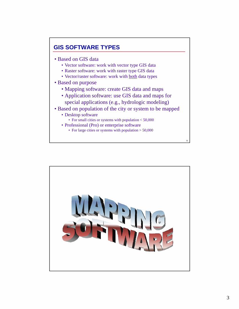
GIS SOFTWARE TYPES
• Based on GIS data• Vector software: work with vector type GIS data• Raster software: work with raster type GIS datayp• Vector/raster software: work with both data types
• Based on purpose• Mapping software: create GIS data and maps• Application software: use GIS data and maps for
special applications (e.g., hydrologic modeling)B d l ti f th it t t b d
5
• Based on population of the city or system to be mapped• Desktop software
• For small cities or systems with population < 50,000• Professional (Pro) or enterprise software
• For large cities or systems with population > 50,000
4
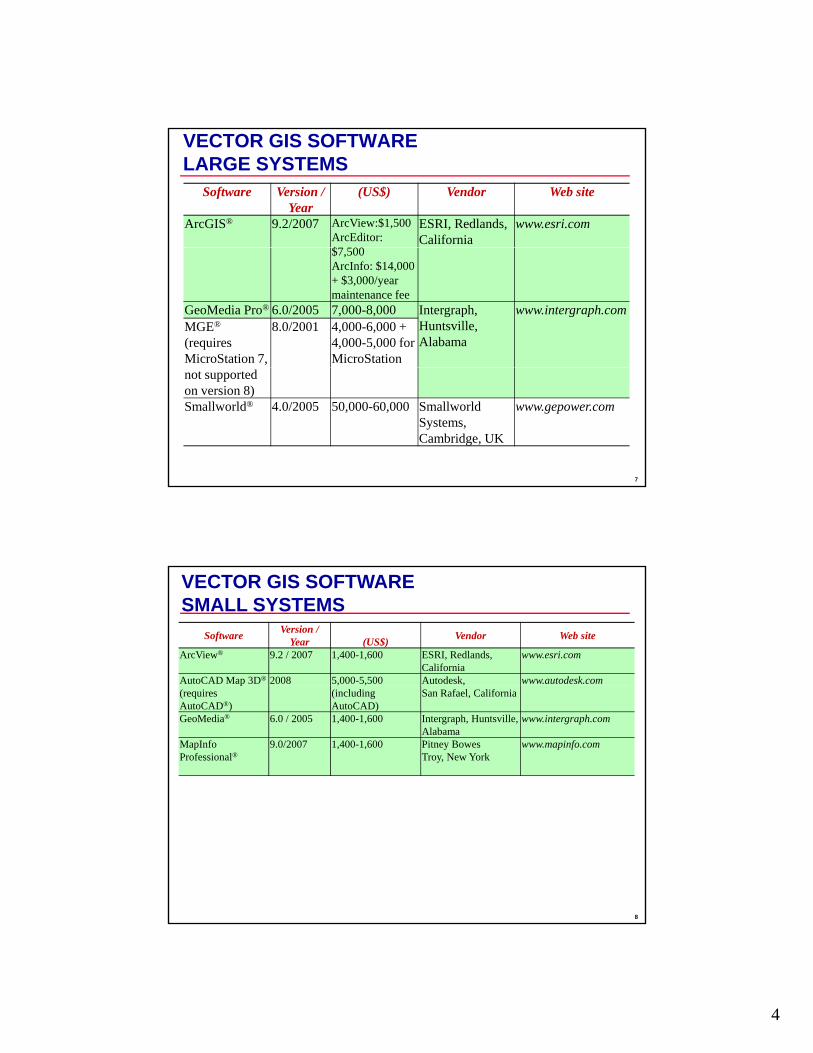
VECTOR GIS SOFTWARELARGE SYSTEMS
Software Version / Year
(US$) Vendor Web site
ArcGIS® 9.2/2007 ArcView:$1,500ArcEditor: $7 500
ESRI, Redlands, California
www.esri.com
$7,500ArcInfo: $14,000 + $3,000/year maintenance fee
GeoMedia Pro® 6.0/2005 7,000-8,000 Intergraph, Huntsville, Alabama
www.intergraph.comMGE®
(requires MicroStation 7,
8.0/2001 4,000-6,000 +4,000-5,000 for MicroStation
7
not supported on version 8)Smallworld® 4.0/2005 50,000-60,000 Smallworld
Systems, Cambridge, UK
www.gepower.com
VECTOR GIS SOFTWARESMALL SYSTEMS
Software Version / Year (US$) Vendor Web site
ArcView® 9.2 / 2007 1,400-1,600 ESRI, Redlands, California
www.esri.com
AutoCAD Map 3D® 2008 5,000-5,500 Autodesk, www.autodesk.comp(requires AutoCAD®)
, ,(including AutoCAD)
,San Rafael, California
GeoMedia® 6.0 / 2005 1,400-1,600 Intergraph, Huntsville, Alabama
www.intergraph.com
MapInfo Professional®
9.0/2007 1,400-1,600 Pitney BowesTroy, New York
www.mapinfo.com
8
5
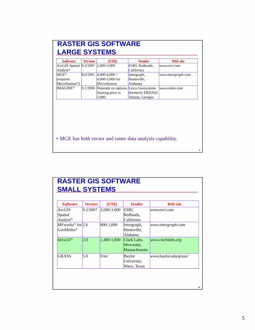
RASTER GIS SOFTWARELARGE SYSTEMS
Software Version (US$) Vendor Web siteArcGIS Spatial Analyst®
9.2/2007 2,000-3,000 ESRI, Redlands, California
www.esri.com
MGE® 8.0/2001 4,000-6,000 + Intergraph, www.intergraph.com(requires MicroStation®)
4,000-5,000 for MicroStation
Huntsville, Alabama
IMAGINE® 9.1/2006 Depends on options. Starting price is 5,000.
Leica Geosystems (formerly ERDAS)Atlanta, Georgia
www.erdas.com
9
• MGE has both vector and raster data analysis capability.
RASTER GIS SOFTWARESMALL SYSTEMS
Software Version (US$) Vendor Web siteArcGIS Spatial
9.2/2007 2,000-3,000 ESRI, Redlands
www.esri.comSpatial Analyst®
Redlands, California
MFworks® for GeoMedia®
2.6 800-1,000 Intergraph, Huntsville, Alabama
www.intergraph.com
Idrisi32® 2.0 1,400-1,600 Clark Labs, Worcester, Massachusetts
www.clarklabs.org
10
GRASS 5.0 Free Baylor University, Waco, Texas
www.baylor.edu/grass/
6
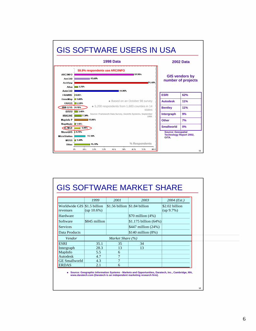
GIS SOFTWARE USERS IN USA
59.9% respondents use ARC/INFO
GIS vendors by
2002 Data1998 Data
Based on an October 98 survey
5,200 respondents from 1,683 counties in 14 states
Source: Framework Data Survey, GeoInfo Systems, September
ESRI 62%
Autodesk 11%
Bentley 11%
Intergraph 9%
ynumber of projects
11
1999.
% Respondents
g p
Other 7%
Smallworld 0%
Source: Geospatial Technology Report 2002, GITA.
GIS SOFTWARE MARKET SHARE 1999 2001 2003 2004 (Est.)
Worldwide GIS revenues
$1.5 billion (up 10.6%)
$1.56 billion $1.84 billion
$2.02 billion (up 9.7%)
Hardware $70 million (4%)Hardware $70 million (4%)Software $845 million $1.175 billion (64%) Services $447 million (24%) Data Products $140 million (8%)
Vendor Market Share (%) ESRI 35.1 35 34 Intergraph 28.3 13 13 MapInfo 5.5 6
12
Source: Geographic Information Systems - Markets and Opportunities, Daratech, Inc., Cambridge, MA, www.daratech.com (Daratech is an independent marketing research firm).
MapInfo 5.5 6Autodesk 4.7 7 GE Smallworld 4.3 7 ERDAS 2.1 6
7
ESRIEnvironmental Systems Research InstituteEstablished in 1969, Headquarters in Redlands, CAMore than 2,900 employees worldwide11 domestic offices in USAOver 75 international distributors in more than 200 countries2004 revenues of over $560 millionAverage annual growth of more than 20%Software used by over 300,000 organizations
ld id
14
worldwideNo. 1 GIS software provider in the world
ESRI and the ESRI Logo are licensed trademarks of Environmental Systems Research Institute, Inc.

8
ESRI GIS SOFTWAREDesktop GIS
ArcGISArcViewArcViewArcEditorArcInfo (old name ARC/INFO)
ArcGIS ExtensionsServer / Enterprise GIS
ArcGIS Server (formerly ArcSDE)ArcIMS
15
Mobile GISArcPad
Developer GISArcObjectsArcEngine
ARCGIS PRODUCTSThree desktop products (modules)1. ArcView2. ArcEditor (includes ArcView)3 ArcInfo (includes ArcEditor)3. ArcInfo (includes ArcEditor)
Functionality increases from ArcView to ArcInfo
16
ArcView ArcEditor ArcInfo Data access ArcView ArcEditor Mapping Plus Plus Customization Advanced geoprocessingSpatial query Data conversion Simple feature editing
Coverage and geodatabase editing
Workstation ArcInfo

9
ARCGIS COMPONENTSArcGIS Desktop is a suite of three integrated
ArcMap
three integrated components1. ArcMap2. ArcCatalog3. ArcToolbox
17
ArcCatalog ArcToolbox
ArcMapPrimary display applicationPerform map-basedPerform map based tasks
Displaying
Editing
Querying
Analyzing
18
Charting
Reporting
10
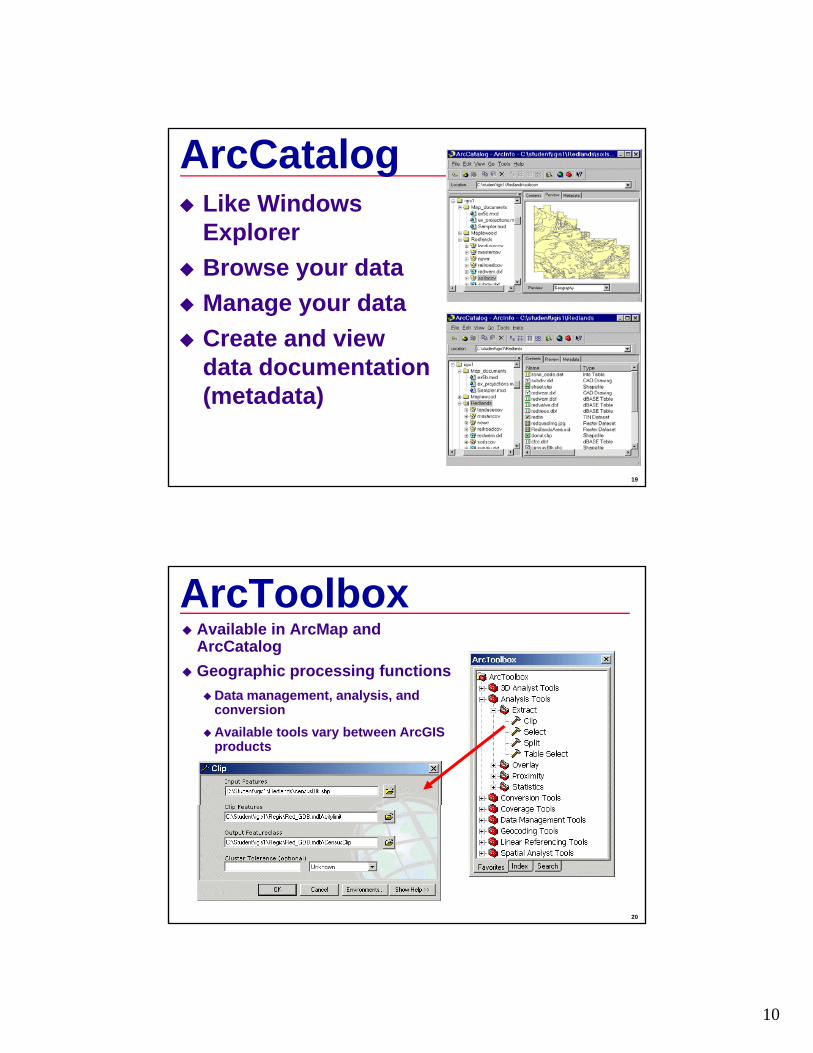
ArcCatalogLike Windows ExplorerBrowse your dataManage your dataCreate and view data documentation
19
data documentation (metadata)
ArcToolboxAvailable in ArcMap and ArcCatalogGeographic processing functions
Data management, analysis, and conversionAvailable tools vary between ArcGIS products
20
11
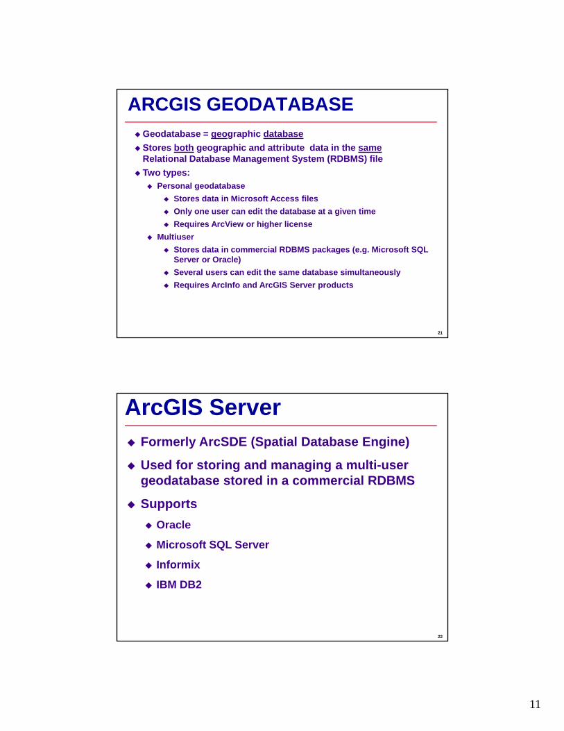
ARCGIS GEODATABASEGeodatabase = geographic databaseStores both geographic and attribute data in the sameRelational Database Management System (RDBMS) fileTwo types:Two types:
Personal geodatabaseStores data in Microsoft Access filesOnly one user can edit the database at a given timeRequires ArcView or higher license
MultiuserStores data in commercial RDBMS packages (e.g. Microsoft SQL
21
Server or Oracle)Several users can edit the same database simultaneouslyRequires ArcInfo and ArcGIS Server products
ArcGIS ServerFormerly ArcSDE (Spatial Database Engine)
Used for storing and managing a multi-user d b d i i l RDBMSgeodatabase stored in a commercial RDBMS
Supports Oracle
Microsoft SQL Server
22
Informix
IBM DB2

12
EXTENSIONSPrograms that run inside a GIS package to expand software capabilities for special
li tiapplications.Spatial Analyst Extension is used to add raster capability for hydrologic modeling.
Also known as “add-on” modules.Can be toggled on/off as needed.
23
Can be toggled on/off as needed.Usually cost additional money.
ArcGIS EXTENSIONSArcMap GPS support (Free!)ArcHydro: hydrologic modeling support (Free!)ArcGIS Spatial Analyst ($2,500): raster data analysis and hydrologic modelingArcGIS 3D Analyst ($2,500): 3d visualizationArcGIS Network Analyst ($2 500): transportation planningArcGIS Network Analyst ($2,500): transportation planningArcGIS Geostatistical Analyst ($2,500)ArcGIS Schematics ArcGIS Survey Analyst ArcGIS Tracking Analyst ArcGIS Data Interoperability ArcGIS Publisher ArcGIS StreetMap ($500)A P f A GIS ($300)
24
ArcPress for ArcGIS ($300)ArcScan for ArcGIS Maplex for ArcGIS ArcGIS Business Analyst ArcGIS Military Analyst Job Tracking for ArcGIS (JTX) (ArcEditor, ArcInfo) Production Line Tool Set (PLTS) for ArcGIS (ArcEditor, ArcInfo) ArcWeb Services
3D ANALYST
13
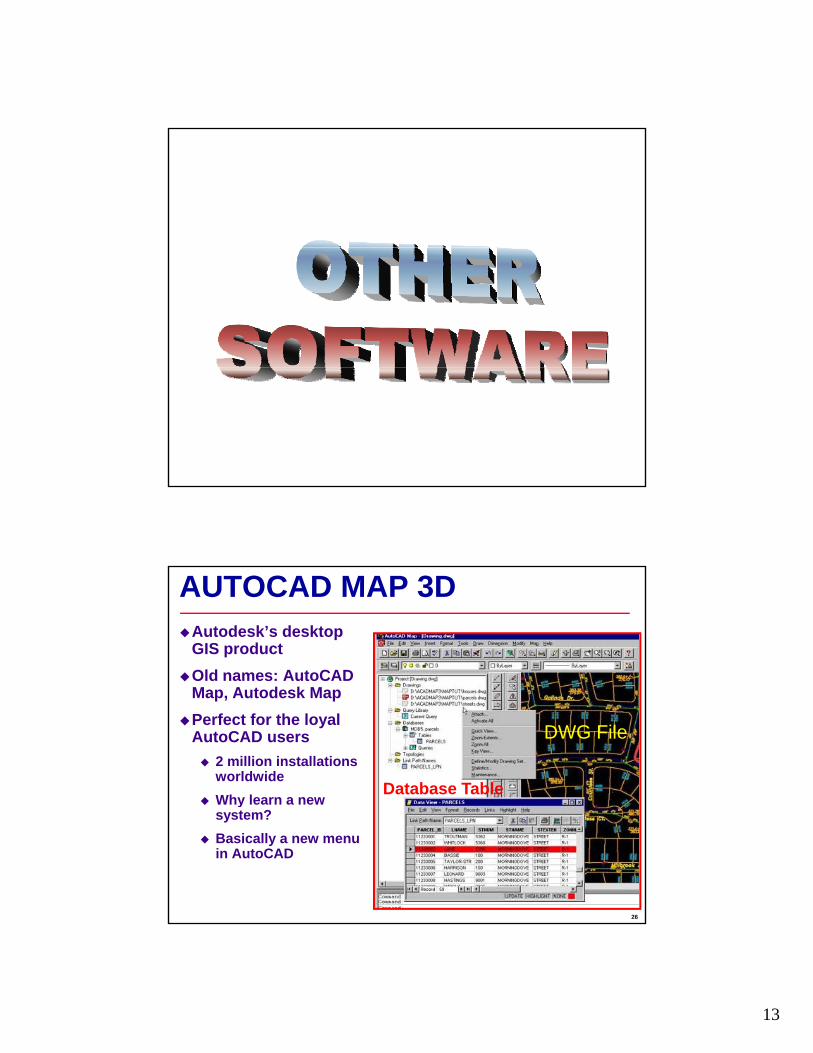
AUTOCAD MAP 3DAutodesk’s desktop GIS productOld names: AutoCAD Map, Autodesk MapPerfect for the loyal AutoCAD users
2 million installations worldwideWhy learn a new
DWG File
Database Table
26
ysystem?Basically a new menu in AutoCAD
14
INTERGRAPH GEOMEDIASupports open (non-proprietary) standardsProvides direct access to all major GIS/CAD data formats without data translationWorks directly with industry-standard relational databases (e.g., Microsoft Access) without additional softwareIt is a product-suite like ArcGIS
GeoMedia: Basic GIS functionality like ArcViewGeoMedia Professional: Advanced GIS functionality like ArcInfo
27
yGrid: Raster data analysis like Spatial AnalystWebMap Pro: Web-based mapping like ArcIMS
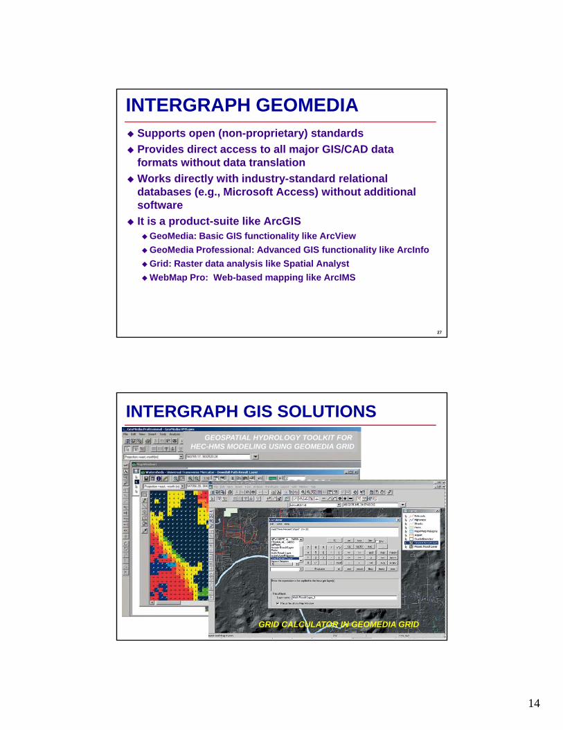
INTERGRAPH GIS SOLUTIONSGEOSPATIAL HYDROLOGY TOOLKIT FOR
HEC-HMS MODELING USING GEOMEDIA GRID
28
GRID CALCULATOR IN GEOMEDIA GRID
15
MAPINFO GIS SOLUTIONSPopular in business industry
Demographic analysis for marketingLocation intelligence: the best place toopen the next McDonald’s or Macy’sNot common in Engineering community
Product suiteMapInfo Professional®: Software for mapping and geographic analysis. MapInfo MapXtreme®: Internet mappingserver for the deployment of mapping applications. MapInfo DriveTime®: A software module for creating drive-time polygons
29
MapInfo DriveTime : A software module for creating drive-time polygons around any location. MapInfo SpatialWare®: An information management tool for storing, managing, and manipulating location-based data. MapInfo MapXtend®: A developer tool for creating location-based wirelesshandheld applications.
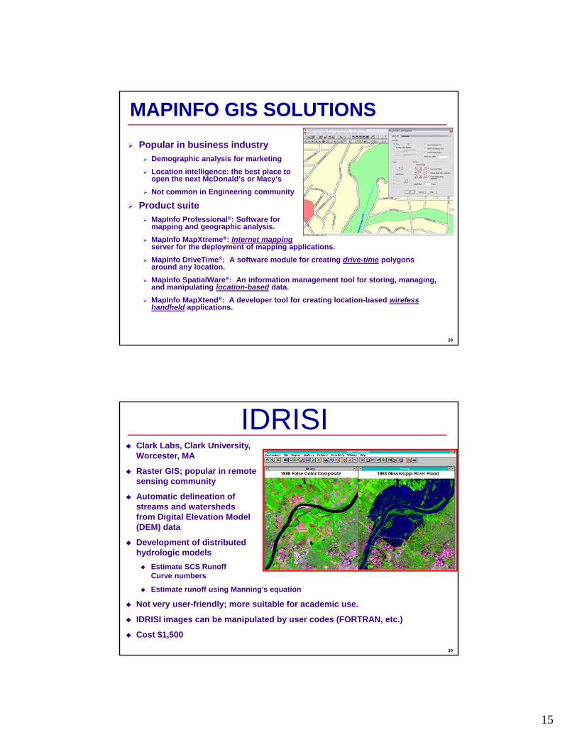
IDRISIClark Labs, Clark University, Worcester, MA
Raster GIS; popular in remote sensing community
Automatic delineation of streams and watersheds from Digital Elevation Model (DEM) data
Development of distributed hydrologic models
Estimate SCS Runoff
30
Curve numbers
Estimate runoff using Manning’s equation
Not very user-friendly; more suitable for academic use.
IDRISI images can be manipulated by user codes (FORTRAN, etc.)
Cost $1,500
16
IMAGE PROCESSING SOFTWAREFor enhancing raster GIS data (aerial photographs, satellite imagery, etc.)
Software Version (US$) Vendor Web siteIMAGINE® 9.1/2006 Depends on
tiLeica Geosystems (f l ERDAS)
www.erdas.comoptions, starting at 5,000
(formerly ERDAS)
Image Analysis® 1.2/2007 2,000-3,000 Leica and ESRI www.erdas.comGeoExpress(formerly MrSID®)
6.1/2006 1,000–3,500 LizardTech www.lizardtech.com
Geomatica® N/A N/A PCI Geomatics www.pcigeomatics.comENVI® 3 4 3 500-4 500 Research Systems www rsinc com
32
ENVI 3.4 3,500 4,500 Research Systems www.rsinc.comER Mapper® 6.1 4,000-6,000 Earth Resources
Mappingwww.ermapper.com
Image Analyst®
for MicroStationN/A N/A Z/I Imaging
Corporationwww.ziimaging.com
17
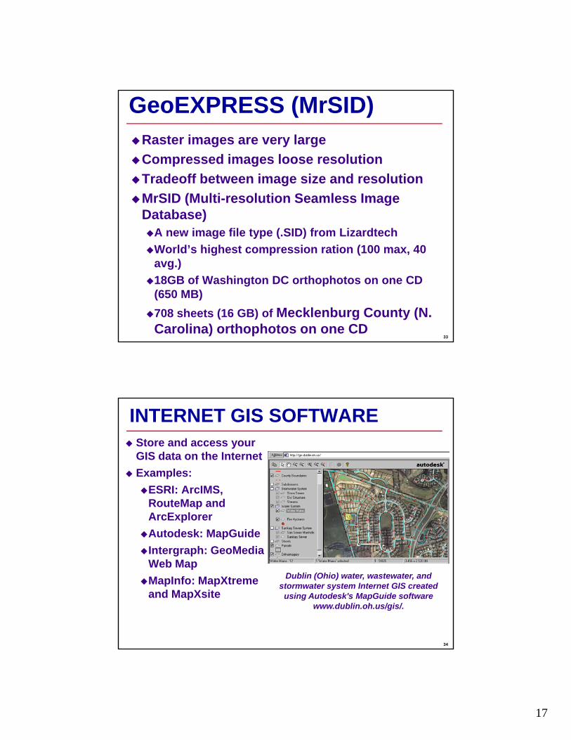
GeoEXPRESS (MrSID)Raster images are very largeCompressed images loose resolutionT d ff b t i i d l tiTradeoff between image size and resolutionMrSID (Multi-resolution Seamless Image Database)
A new image file type (.SID) from LizardtechWorld’s highest compression ration (100 max, 40
33
avg.)18GB of Washington DC orthophotos on one CD (650 MB)708 sheets (16 GB) of Mecklenburg County (N. Carolina) orthophotos on one CD
INTERNET GIS SOFTWAREStore and access your GIS data on the InternetExamples:
ESRI: ArcIMS, RouteMap and ArcExplorerAutodesk: MapGuideIntergraph: GeoMedia Web Map
34
Web MapMapInfo: MapXtremeand MapXsite
Dublin (Ohio) water, wastewater, and stormwater system Internet GIS created
using Autodesk's MapGuide software www.dublin.oh.us/gis/.

18
ASSET MANAGEMENT SOFTWARE
Software Vendor Web siteCASS WORKS RJN Group, Inc www.rjn.comCityworks Azteca Systems www.azteca.comy yFRAMME Intergraph www.intergraph.comGBA Water Master and Sewer Master
GBA Master Series
www.gbamasterseries.com
GeoWater and GeoWasteWater
MicroStation www.bentley.com
Infrastructure Hansen www.hansen.com
35
management System (IMS)
Information Technologies
WATERview and SEWERview
CarteGraph Systems
www.cartegraph.com
WATER SYSTEM MODELING SOFTWARESoftware Vendor Web site
CEDRA AVWater CEDRA Corporation www.cedra.comWaterGEMS WaterCAD
Haestad Methods www.haestad.comWaterCADCybernet InfoWaterH2OMAP WaterH2ONET
MWH Soft www.mwhsoft.com
MIKE NET DHI Water & Environment www.dhi.dkInfoWorksInfoNet
Wallingford Software www.wallingfordsoftware.com
36
HydroWorksPIPE2000 University of Kentucky www.kypipe.comSynerGEE Advantica Stoner www.stoner.com

19
SEWER SYSTEM MODELING SOFTWARESoftware Vendor Web site
CEDRA AVSand CEDRA Corporation www.cedra.comInfoSWMMH2OMAP Sewer
MWH Soft www.mwhsoft.com2
InfoWorksInfoNetHydroWorks
Wallingford Software www.wallingfordsoftware.com
Mike UrbanMouse GIS
DHI, Inc. www.dhisoftware.com
PCSWMM GIS Computational Hydraulics Int. www.computationalhydraulics.comSewerGEMSSewerCAD and
Haestad Methods www.haestad.com
37
StormCADXP-SWMM XP-Software www.xpsoftware.com
STORMWATER, WATERSHED, AND HYDROLOGIC MODELING SOFTWARE
Software Vendor Web siteHydro Extension ESRI www.esri.comMike SHEMike 11 GIS
DHI Water & Environment
www.dhi.dkMike 11 GISMike Basin
Environment
HEC-Geo HMS & HEC-Geo RAS
Hydrologic Engineering Center (HEC)
www.hec.usace.army.mil/software/
BASINS U.S. EPA www.epa.gov/OST/BASINS/GIS Hydro University of Texas at
Austinwww.ce.utexas.edu/prof/maidment/
Watershed Brigham Young www.ems-i.com
38
Modeling System UniversityRiver Modeling System (RMS) and RiverCAD
Boss International www.bossintl.com

20
SOFTWARE SELECTION
Conduct Needs Assessment
Needs assessment compares softwareNeeds assessment compares software and develops a decision matrix of user needs (applications) and available software to help select the most appropriate software
40
Compare software with each other
Compare software with your needs
21
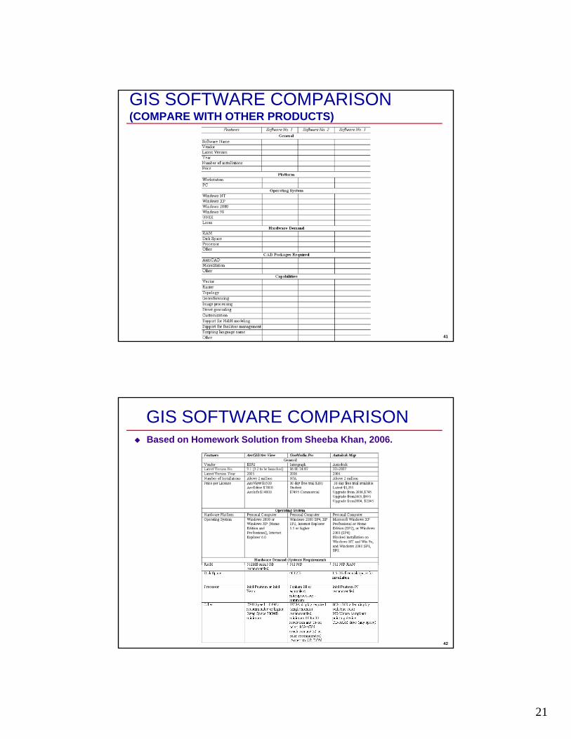
GIS SOFTWARE COMPARISON(COMPARE WITH OTHER PRODUCTS)
41
GIS SOFTWARE COMPARISONBased on Homework Solution from Sheeba Khan, 2006.
42
22
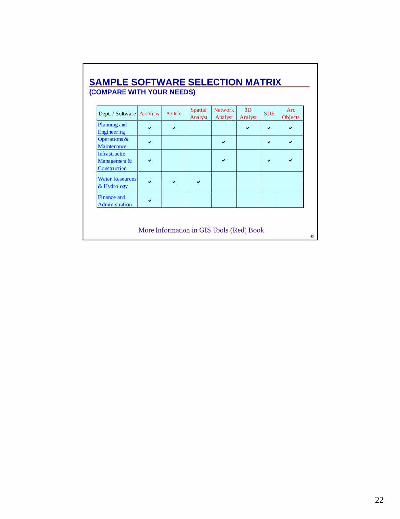
SAMPLE SOFTWARE SELECTION MATRIX(COMPARE WITH YOUR NEEDS)
Dept. / Software ArcView ArcInfoSpatial Analyst
Network Analyst
3D Analyst SDE Arc
ObjectsPlanning and Engineering a a a a a
Operations & Maintenance a a a a
Infrastructre Management & Construction
a a a a
Water Resources a a a
43
& Hydrology a a a
Finance and Administration a
More Information in GIS Tools (Red) Book


![Command Quick Guide R12 – 2007 Related Command · PDF fileAutoCAD Productivity AutoCAD Command Quick Guide Appendix [ ] ... 3D 3DARRAY '3DCLIP ... ALIGN ALIGNSPACE](https://static.fdocuments.us/doc/165x107/5aa132c47f8b9ac67a8b7ba7/command-quick-guide-r12-2007-related-command-productivity-autocad-command.jpg)


