Learning June 2004 Lydeana Martin New River Valley Planning District Commission.
42
Learning Learning June 2004 June 2004 Lydeana Martin Lydeana Martin New River Valley New River Valley Planning Planning District District Commission Commission
-
Upload
justin-bell -
Category
Documents
-
view
214 -
download
1
Transcript of Learning June 2004 Lydeana Martin New River Valley Planning District Commission.

LearningLearning
June 2004June 2004
Lydeana MartinLydeana Martin
New River Valley New River Valley Planning District Planning District
CommissionCommission

MitigationMitigation
““Sustained action taken to reduce or eliminate Sustained action taken to reduce or eliminate long-term risk to human life and propertylong-term risk to human life and property from from natural hazards and their effect.”natural hazards and their effect.”– National Flood Insurance Program (esp. ordinance National Flood Insurance Program (esp. ordinance
component)component)
– Buying, elevating and/or moving flood-prone structuresBuying, elevating and/or moving flood-prone structures
Part of Emergency ManagementPart of Emergency Management– Not emergency preparedness & responseNot emergency preparedness & response

Why We’re Doing ThisWhy We’re Doing This
Meet Meet Federal eligibilityFederal eligibility for FEMA assistance, for FEMA assistance, Disaster Mitigation Act 2000 (local plans by Disaster Mitigation Act 2000 (local plans by 11/1/04)11/1/04)
Scenarios for funding:Scenarios for funding:– Pre-disaster mitigationPre-disaster mitigation ($250,000 state) ($250,000 state)– Post-disaster mitigationPost-disaster mitigation (up to 7.5% of total response & (up to 7.5% of total response &
recovery assistance); following Presidentially-declared recovery assistance); following Presidentially-declared disasterdisaster
– Other federal collaborations in the future?Other federal collaborations in the future?– Each locality: list of priority mitigation projectsEach locality: list of priority mitigation projects
It makes senseIt makes sense: Save lives, property, protect : Save lives, property, protect resourcesresources

Regional Hazard Regional Hazard Mitigation PlanningMitigation Planning
Public participationPublic participation HazardsHazards Risk Assessment and VulnerabilityRisk Assessment and Vulnerability Existing MitigationExisting Mitigation Additional Mitigation optionsAdditional Mitigation options ““Local Plans,” implementation and project list(s)Local Plans,” implementation and project list(s) Plan MaintenancePlan Maintenance AdoptionAdoption
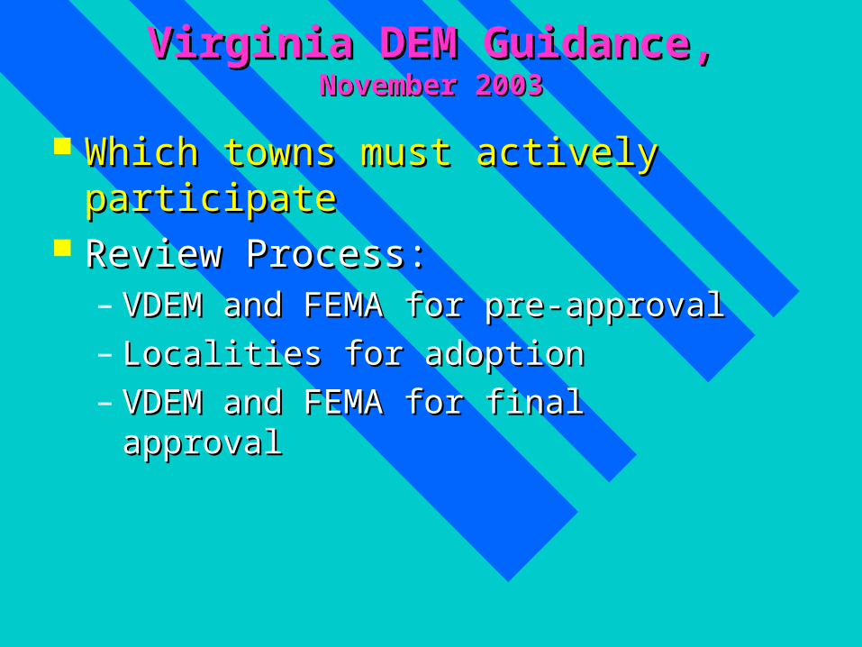
Virginia DEM Guidance, Virginia DEM Guidance, November 2003November 2003
Which towns must actively participateWhich towns must actively participate Review Process:Review Process:
– VDEM and FEMA for pre-approvalVDEM and FEMA for pre-approval– Localities for adoptionLocalities for adoption– VDEM and FEMA for final approvalVDEM and FEMA for final approval

How We’re Doing ThisHow We’re Doing This
Public Planning ProcessPublic Planning Process– Monthly meetings began June, 2002Monthly meetings began June, 2002– Some special meetings in Towns as requestedSome special meetings in Towns as requested– Special Local Government Planners meetings Special Local Government Planners meetings
and Admin’s and Managers and Admin’s and Managers – Participate in regional conferencesParticipate in regional conferences
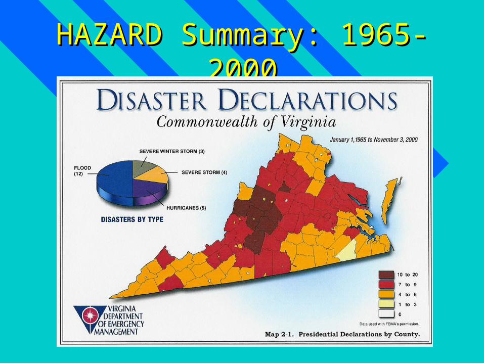
HAZARD Summary: 1965-2000HAZARD Summary: 1965-2000

SUMMARY of HAZARDS SUMMARY of HAZARDS NRV MITIGATION PRIORITIES
by HAZARDSize of circle = Mitigation opportunities
0
2
4
6
8
10
12
0 2 4 6Frequency
Sev
erit
y o
r Im
pac
t
Based on 125 years
Based on 125-year history

FLOODSFLOODS: : HistoryHistory
WORST (Recent) CASEWORST (Recent) CASE: :
DateDate: February 22, 2003: February 22, 2003
SeveritySeverity: rain on ice/snow : rain on ice/snow accum;Presidential-accum;Presidential-disaster declaration in disaster declaration in Montgomery Co.Montgomery Co.
Location:Location: NRV NRV
Damages:Damages: one person one person died, a few homes died, a few homes flooded, several small flooded, several small bridges lostbridges lost
Photo from The Roanoke Times
Photo by Scott Stewart
N Fk Roanoke R.
Allegheny Springs

Flood, 2003Flood, 2003
Town of PulaskiTown of Pulaski
Downtown Pulaski
Rt 99 PulaskiDora Hwy Pulaski

Flood, 2003Flood, 2003 Floyd and Giles Floyd and Giles
Co.Co.– State road damage State road damage
($200,000 in ($200,000 in Floyd County), Floyd County), private bridges, private bridges, small stream small stream floodingflooding
Beside 460 in Giles Co.
RU Dedmon clean-up
Rt. 8, Floyd Co.
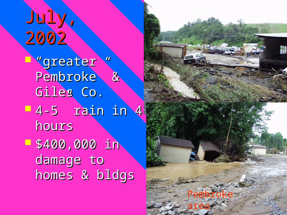
July, 2002July, 2002
““greater Pembroke” greater Pembroke” & Giles Co.& Giles Co.
4-5” rain in 4 hours4-5” rain in 4 hours $400,000 in damage $400,000 in damage
to homes & bldgsto homes & bldgs
Pembroke area
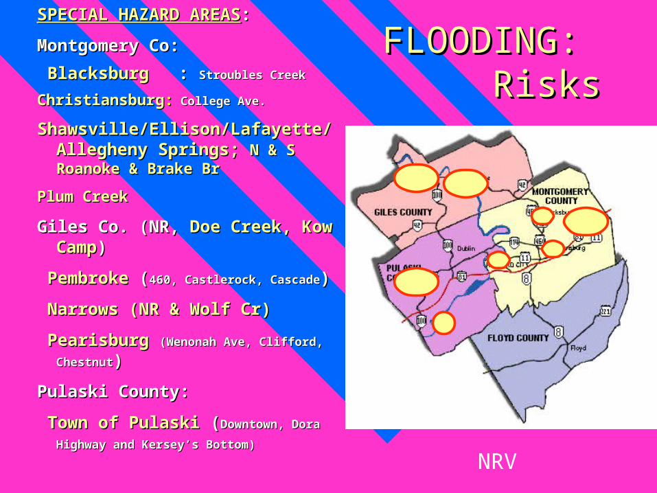
FLOODING: FLOODING: RisksRisks
SPECIAL HAZARD AREASSPECIAL HAZARD AREAS: :
Montgomery Co:Montgomery Co:
BlacksburgBlacksburg : : Stroubles CreekStroubles Creek
ChristiansburgChristiansburg:: College Ave. College Ave.
Shawsville/Ellison/Lafayette/Allegheny Shawsville/Ellison/Lafayette/Allegheny Springs; Springs; N & S Roanoke & Brake BrN & S Roanoke & Brake Br
Plum CreekPlum Creek
Giles Co. (NR, Giles Co. (NR, Doe Creek, Kow Doe Creek, Kow CampCamp))
PembrokePembroke ( (460, Castlerock, Cascade460, Castlerock, Cascade))
Narrows (NR & Wolf Cr)Narrows (NR & Wolf Cr)
PearisburgPearisburg (Wenonah Ave, Clifford, Chestnut(Wenonah Ave, Clifford, Chestnut) )
Pulaski County:Pulaski County:
Town of PulaskiTown of Pulaski ( (Downtown, Dora Highway Downtown, Dora Highway
and Kersey’s Bottom)and Kersey’s Bottom)
NRV

Closer Look at Closer Look at High Risk AreasHigh Risk Areas

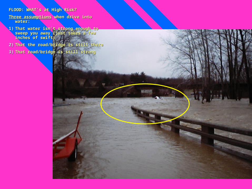
FLOOD: FLOOD: WHAT’s at WHAT’s at High Risk?High Risk?
North Fork of Roanoke River
FLOOD: WHAT’s at High Risk?FLOOD: WHAT’s at High Risk?
Three assumptionsThree assumptions when drive into water: when drive into water:
1)1) That water isn’t strong enough to sweep That water isn’t strong enough to sweep you away (just takes a few inches of you away (just takes a few inches of swift)swift)
2)2) That the road/bridge is still thereThat the road/bridge is still there
3)3) That road/bridge is still strongThat road/bridge is still strong

2002 2002
Community Name
# NFIP Policies In-force
Insurance In-force # Structures Total Value
Blacksburg, Town of 13 $2,386,900 5 $4,500,000 **Christiansburg, Town of 20 $2,485,200 35 $3,000,000Floyd County 12 $822,000Giles County 50 $3,564,100Montgomery County 151 $15,289,700 98 $11,600,000Narrows, Town of 17 $2,129,100 97 $5,500,000Pearisburg, Town of 3 $159,300 3 $1,500,000Pembroke, Town of 23 $1,879,000 46 $5,000,000Pulaski County 63 $5,737,900 15 $400,000Pulaski, Town of 58 $9,186,000 200 $37,900,000Radford, City of 17 $3,689,600 unknown unknownRich Creek, Town of 6 $390,900 1 $150,000TOTALS 433 $47,719,700 499 $69,400,000*Based on cursory tax assessment and flood map review of sub-areas.County data does not include incorporated Town data.**Based on past damage information.Not Participating: Towns of Dublin, Floyd and Glen Lyn.
Structures in Large, Populated High Risk areas*
no large high hazard areassee Town data
Summary of NRV Insurance and Risk Data

Existing FLOOD Existing FLOOD MitigationMitigation Preventative/legal/policyPreventative/legal/policy: Zoning/floodplain : Zoning/floodplain
managementmanagement Property Protection: Property Protection: Acquisition,Acquisition, Relocating, Relocating,
elevating, retrofitting, insuranceelevating, retrofitting, insurance Emergency ServicesEmergency Services: Monitoring, Warning, etc.: Monitoring, Warning, etc. StructuresStructures: channels, floodwalls, dry hydrant, : channels, floodwalls, dry hydrant,
drainage system maintenance, etc.drainage system maintenance, etc. Natural Resource ProtectionNatural Resource Protection: wetlands, setbacks, : wetlands, setbacks,
BMP’s, E&SBMP’s, E&S Public InformationPublic Information: newsletter, library resources, : newsletter, library resources,
maps, technical assistance, environmental maps, technical assistance, environmental educationeducation

Emergency ServicesEmergency Services: : IFLOWSIFLOWS
Automated Rain GaugesAutomated Rain Gauges Updated every 15 Updated every 15
minutes minutes www.afws.netwww.afws.net
FLOODING: Existing Mitigation
NE Floyd Co E Montgomery Co
Giles Co
W Pulaski Co

Preventative/legal/policyPreventative/legal/policy– Integrate hazard mitigation Integrate hazard mitigation
planning into planning into Comprehensive PlanComprehensive Plan– Better Better enforcement and/or enforcement and/or
tighteningtightening of Floodplain of Floodplain regulationsregulations
– Forest Conservation: Forest Conservation: » 1 AC Trees=5,000+cubic ft water 1 AC Trees=5,000+cubic ft water
retentionretention» 1 AC Trees=$10,000+ on 1-time storm 1 AC Trees=$10,000+ on 1-time storm
water restructurewater restructureSource: American Forests, June, 2002Source: American Forests, June, 2002
– Storm water management Storm water management ordinanceordinance
– Community Rating SystemCommunity Rating System
FLOODING: Additional Mitigation

– Enhanced Enhanced stormdrain stormdrain maintenancemaintenance (routine, before and (routine, before and after storms)—after storms)—Pulaski, PembrokePulaski, Pembroke
– ““Farm fencesFarm fences””
FLOODING: Existing Mitigation
Farm Fence in Floyd Co
Emergency Services:Emergency Services:– Work toward Work toward compatible communication compatible communication
systemssystems across NRV (Homeland Security) across NRV (Homeland Security)– Reverse-911Reverse-911 or other electronic notification or other electronic notification– Develop Develop swift-water rescueswift-water rescue capacity in NRV capacity in NRV
FLOODING: Additional Mitigation

DROUGHTDROUGHT • "drought" means a "drought" means a
moisture deficit bad moisture deficit bad enough to have enough to have socialsocial, , environmentalenvironmental or or economic effectseconomic effects (Drought Mitigation (Drought Mitigation Center)Center)
• Unlike other natural Unlike other natural disasters, the “event” disasters, the “event” can last for years—no can last for years—no rushing sirensrushing sirens
Mountain Lake, October, 2002

DROUGHT: DROUGHT: HistoryHistoryWORST (Recent) CASE:
Date:1998-2002
Severity: D3 “Extreme Drought”
Location: eastern US; all NRV
Damages: $10 mill Agri. Loss; extreme fire danger; widespread water shortages or restrictions
Floyd County
Montgomery County
Giles County
Pulaski County
# Farm Facilities (developed springs, wells) 560 370 100 200
Value of Farm Facilities Lost $300,000 $200,000 $100,000 $200,000$ Livestock, Loss of Weight gain $3,700,000 $2,500,000 $1,000,000 $2,000,000Total $ Loss $4,000,000 $2,700,000 $1,100,000 $2,200,000
Estimate of Agricultural Losses, Drought 2002

DROUGHT: DROUGHT: RiskRiskFREQUENCY:
Some level most every ten years; most recent probably 50-year event?
SPECIAL HAZARD AREAS:
Agricultural areas;
Floyd County (limited central water)
Eco-tourism sites dependent on water
Damages:
Wells, springs, lakes go dry
Wildfires
55
11413
880
478328 11
0
50
100
150
200
"New wells" Replacement
Pulaski
Radford City
Montgomery
Giles
Floyd
NRV Well Permits, July-Sept, 2002

DROUGHT: DROUGHT: MitigationMitigationEXISTING
Growth management tools: zoning, storm
B’burg Zoning to protect groundwater recharge
VA Emergency Declaration; new water planning requirements
USDA alternative water source program

DROUGHT: DROUGHT: MitigationMitigationOTHER MITIGATIONOTHER MITIGATION
Conservation programsConservation programs– EducationEducation– Low-use appliancesLow-use appliances
Protect Groundwater, esp. rechargeProtect Groundwater, esp. recharge – Agricultural techniquesAgricultural techniques– Forest ConservationForest Conservation– Stormwater management: low-impact Stormwater management: low-impact
developmentdevelopment Alternative water suppliesAlternative water supplies
– Improve efficiency storage and transportImprove efficiency storage and transport– Additional public sourcesAdditional public sources– Interconnecting, creating regional systemInterconnecting, creating regional system– Rain catchment systemsRain catchment systems– Alternative sources for agriculture needsAlternative sources for agriculture needs– Contingency plansContingency plans

WILDFIREWILDFIREWORST (Recent) CASEsWORST (Recent) CASEs: :
DateDate: From January to Mid-Oct, 2002, : From January to Mid-Oct, 2002,
SeveritySeverity: : 1,629 wildfires that burned 13,195 acres 1,629 wildfires that burned 13,195 acres
Location:Location: VirginiaVirginia
Damages:Damages:
Impact to wildlife, watersheds, threatens homesImpact to wildlife, watersheds, threatens homes
April 16-19, 2003 142 AC on Draper Mtn; 100 AC on Poor Mountain

WILDFIRE: WILDFIRE: RisksRisks
FREQUENCYFREQUENCY::Drought, oDrought, other weather factorsther weather factors, , (such as lightning, wind, temperature, (such as lightning, wind, temperature, relative humidity and atmospheric stability) relative humidity and atmospheric stability) SEE INDEXSEE INDEX
Human activityHuman activity It’s not a matter of if but when wildfires of It’s not a matter of if but when wildfires of
the [massive] magnitude . . Will occur in the [massive] magnitude . . Will occur in the Southern Appalachians where our the Southern Appalachians where our forests are less open and fuels are far forests are less open and fuels are far greater. . . Adding to building up is greater. . . Adding to building up is Southern pine beetle outbreak and Southern pine beetle outbreak and
hemlock woolly adelgidhemlock woolly adelgid” ” A Univ. of TN fire A Univ. of TN fire ecologist warned, July 8, 2002ecologist warned, July 8, 2002
Total fires Total AC Avg ACFloyd County 47 71 1.5Giles County 9 44 4.9Montgomery Co. 68 147.9 2.1Pulaski Co. 55 229 4.1Source: VA Dept. of Forestry
Forest Fire--5-year Average

WILDFIRE: WILDFIRE: RisksRisks SPECIAL HAZARD AREASSPECIAL HAZARD AREAS: : Intrusion of residential development into Intrusion of residential development into
woodlandwoodland Based on Slope and Fuels:Based on Slope and Fuels:
» Giles County: 76% woodlandGiles County: 76% woodland» Giles, Montgomery, Pulaski and RadfordGiles, Montgomery, Pulaski and Radford: :
steeply sloped (generally 20%+)steeply sloped (generally 20%+) Logging, sawmill, or tire pilesLogging, sawmill, or tire piles
Photo by US Forest Service Hot Shots

WILDFIRE: WILDFIRE: RisksRisks SPECIAL HAZARD AREAS (cont’d)SPECIAL HAZARD AREAS (cont’d): : Brush Mountain in Montgomery Co;Brush Mountain in Montgomery Co; Slate Mountain in Floyd Co.Slate Mountain in Floyd Co. Camp Powhatan in Pulaski Co.Camp Powhatan in Pulaski Co.
WILDFIRE: ESTIMATE of HIGH RISK
HomesTotal Value of Homes
Brush Mountain 25 $7,500,000Slate Mountain 35 $3,500,000
Brush Mountain
Brush MountainSlate Mountain

WILDFIRE: WILDFIRE: MitigationMitigationEXISTING EXISTING
VA Forestry Smokey the Bear, Fire Risk VA Forestry Smokey the Bear, Fire Risk Index, Burn laws, Dry Hydrant and Index, Burn laws, Dry Hydrant and cross-training fire-fightingcross-training fire-fighting
New River Highlands RC&D Woodland New River Highlands RC&D Woodland home/mitigation demo site(s)home/mitigation demo site(s)
Firewise/VA Forestry resources available Firewise/VA Forestry resources available for home-builders, home-buyers, for home-builders, home-buyers, government officialsgovernment officials
Federal Wildland Fire Policy, US Forest Federal Wildland Fire Policy, US Forest Service community initiativesService community initiatives

WILDFIRE: WILDFIRE: MitigationMitigationOTHER MITIGATION: Zoning, Subdivision Ord.’sOTHER MITIGATION: Zoning, Subdivision Ord.’s
Slope (where we build)Slope (where we build)– Level if possible, or 30 set backLevel if possible, or 30 set back
Fuel (building design, material, maintenance, and Fuel (building design, material, maintenance, and landscaping)landscaping)
Roof & exterior walls: Roof & exterior walls: fire resistive materialsfire resistive materials
Keep flammable vegetation, wood piles, and Keep flammable vegetation, wood piles, and debris awaydebris away from from the walls. the walls.
ScreenScreen your chimneys, exterior attic and underfloor vents with your chimneys, exterior attic and underfloor vents with noncombustible wire mesh screening, no larger than 1/2 inchnoncombustible wire mesh screening, no larger than 1/2 inch
Eliminate ladder fuelsEliminate ladder fuels and keep and keep Trees and shrubs 30 feet from Trees and shrubs 30 feet from large windowslarge windows
Create fire breaks/ defensible open spaceCreate fire breaks/ defensible open space

WILDFIRE: WILDFIRE: MitigationMitigationOTHER MITIGATIONOTHER MITIGATION
Involve Forester in Subdivision plat reviewInvolve Forester in Subdivision plat review Fire-fighting (access and resources)Fire-fighting (access and resources) Educate home-builders and home-buyersEducate home-builders and home-buyers Additional dry-hydrantsAdditional dry-hydrants Adequate water resourcesAdequate water resources

EARTHQUAKE: EARTHQUAKE: RisksRisks SPECIAL SPECIAL
HAZARD AREAHAZARD AREA: : 30 km around 30 km around
Pearisburg Pearisburg (Dr. (Dr. Chapman)—not surface faultsChapman)—not surface faults
POTENTIAL POTENTIAL IMPACT:IMPACT:
Old brick or block Old brick or block construction (most construction (most deaths and injuries deaths and injuries from structures)from structures)
Fire house doors and Fire house doors and hospital equipment hospital equipment rendered inoperablerendered inoperable
EARTHQUAKE: EARTHQUAKE: MitigationMitigationEXISTING MITIGATION:EXISTING MITIGATION:
Virginia Building CodeVirginia Building Code
International Building Code; more stringent in building International Building Code; more stringent in building strength/flexibility; 1 in 2,500-year eventstrength/flexibility; 1 in 2,500-year event
MITIGATION OPPORTUNITIES:MITIGATION OPPORTUNITIES:
Be aware of high danger areas: such as gas pipelines Be aware of high danger areas: such as gas pipelines near dense populationnear dense population
Be sure that new hospitals and firehouses are properly Be sure that new hospitals and firehouses are properly designed designed
““Seismic strengthening/flexibility” of critical facilitiesSeismic strengthening/flexibility” of critical facilities
Beware deep soils in risk areas, particularly with Beware deep soils in risk areas, particularly with bridgesbridges

NRV Plan Mission:NRV Plan Mission:
Minimize the loss of life and property Minimize the loss of life and property caused by natural hazards by focusing caused by natural hazards by focusing on on likely eventslikely events, , high-riskhigh-risk areas, and areas, and cost-effectivecost-effective mitigation opportunities. mitigation opportunities.

Lessons Learned: ChallengesLessons Learned: Challenges
NewnessNewness: lack of knowledge & guidance: lack of knowledge & guidance Timing and CoordinationTiming and Coordination: little benefit of : little benefit of
centralized resourcescentralized resources Lack of DataLack of Data: Infrastructure and : Infrastructure and Past DamagePast Damage Variety of Input NeededVariety of Input Needed (i.e. Pembroke) (i.e. Pembroke) Language BarriersLanguage Barriers (i.e. 100-year flood) (i.e. 100-year flood) Tools neededTools needed (HAZUS, and risk terminology (HAZUS, and risk terminology
for non-floods)for non-floods) Priorities and OpportunitiesPriorities and Opportunities (concrete (concrete
benefit?, post-disaster by other Fed’s)benefit?, post-disaster by other Fed’s)

SuccessesSuccesses Variety of Input: informative, hopeful, Variety of Input: informative, hopeful,
realreal– Local gov’t managers, planners, building Local gov’t managers, planners, building
officials, zoning officials, emergency officials, zoning officials, emergency personnelpersonnel
– Citizens groups, Amer. Red Cross, RAAP, Citizens groups, Amer. Red Cross, RAAP, Rainwater Harvesting, Inc.Rainwater Harvesting, Inc.
– State and Fed agencies, including Virginia State and Fed agencies, including Virginia Tech Tech

SuccessesSuccesses Data to Information: Data to Information:
– Past weather eventsPast weather events– Flood maps and tax parcelFlood maps and tax parcel– Well replacement points mapped in FCWell replacement points mapped in FC
New Processes:New Processes:– VA Dept. of Health GPS/GISVA Dept. of Health GPS/GIS

NRV MITIGATION NRV MITIGATION THEMES/GOALSTHEMES/GOALS Opportunities to mitigate :Opportunities to mitigate :
– Pursue Pursue mitigation opportunities with State and mitigation opportunities with State and FedsFeds: which include detailed studies, : which include detailed studies, acquisition, structural projects, demonstration acquisition, structural projects, demonstration projectsprojects
– RReview and update ordinanceseview and update ordinances– Develop/integrate informationDevelop/integrate information
» GIS layers: floodplains, slopes, tree cover, modelingGIS layers: floodplains, slopes, tree cover, modeling» Educate citizens regarding hazards and mitigation, Educate citizens regarding hazards and mitigation,
such as flood insurance, retrofitting, natural resource such as flood insurance, retrofitting, natural resource protection, easements protection, easements
» Regional Telecommunications capacity and early Regional Telecommunications capacity and early warning mechanismswarning mechanisms
– Consider Consider Regional Swift Water Rescue, Regional Swift Water Rescue, Damage-AssessmentDamage-Assessment , , Regional Water SupplyRegional Water Supply

NRV Hazard Mitigation PlanNRV Hazard Mitigation Plan
www.nrvpdc.org/HazardMitigationPlan/Hawww.nrvpdc.org/HazardMitigationPlan/HazardMitigationPlan.htmzardMitigationPlan.htm
Lydeana Martin Lydeana Martin [email protected]@nrvdc.org, 540 , 540 639-9313639-9313