le el iv E Map Legend Fire Operations Plan Desert Telopea West Big Desert - Telopea Central Big...
1
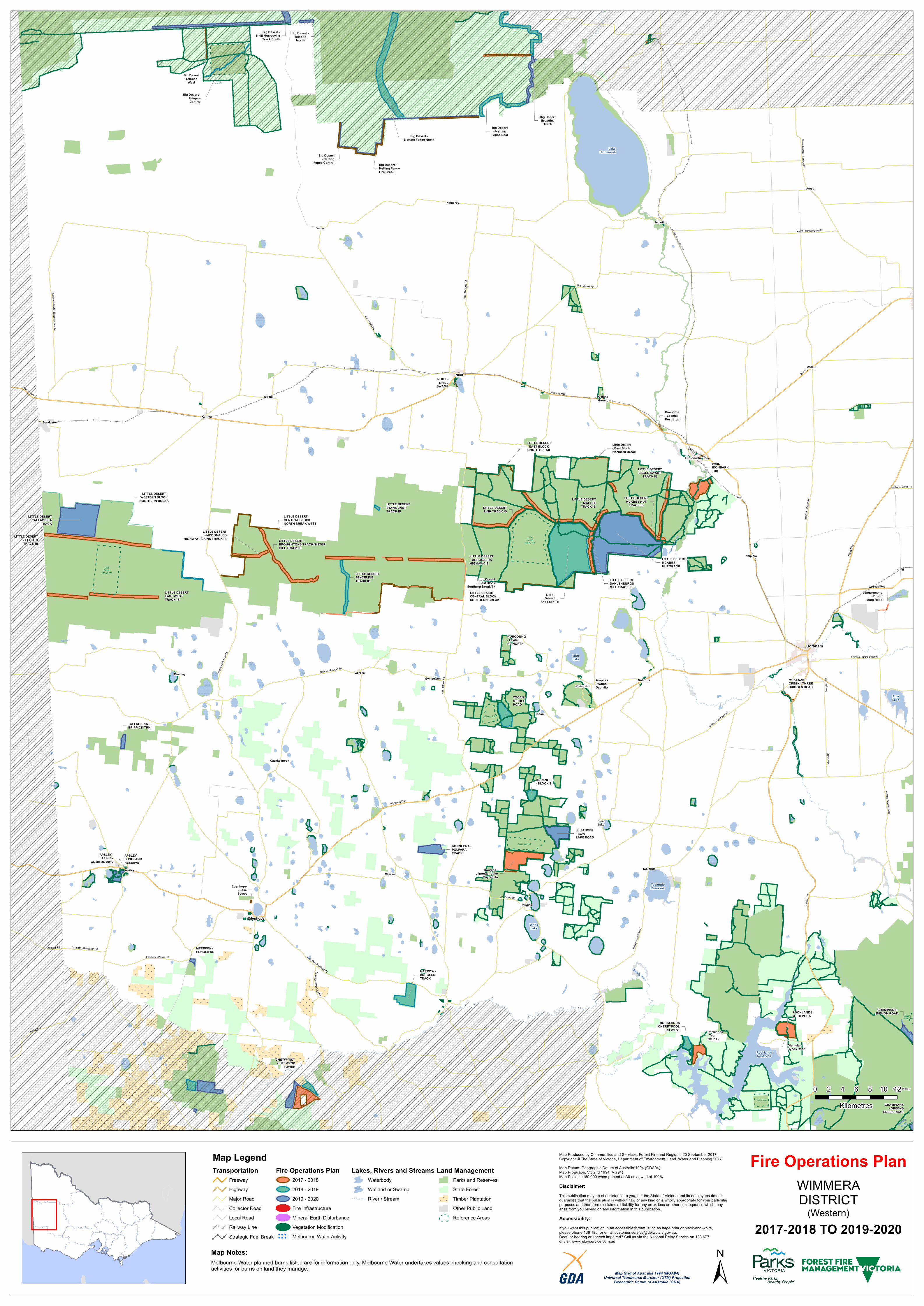
# # # # # # # # # # # # # # # # # # # # # # # # # # # # # # # # # # # # # # # # # # # # # # # # # # # # # # # # # # # # # # # # # # # # # # # # # # # # # # # # # # # # # # # # # # # # # # # # # # # # # # # # # # # # # # # # # # # # # # # # # # # # # # # # # # # # # # # # # # # # # # # # # # # # # # # # # # # # # # # # # # # # # # # # # # # # # # # # # # # # # # # # # # # # # # # # # # # # # # # # # # # # # # # # # # # # # # # # # # # # # # # # # # # # # # # # # # # # # # # # # # # # # # # # # # # # # # # # # # # # # # # # # # # # # # # # # # # # # # # # # # # # # # # # # # # # # # # # # # # # # # # # # # # # # # # # # # # # # # # # # # # # # # # # # # # # # # # # # # # # # # # # # # # # # # # # # # # # # # # # # # # # # # # # # # # # # # # # # # # # # # # # # # # # # # # # # # # # # # # # # # # # # # # # # # # # # # # # # # # # # # # # # # # # # # # # # # # # # # # # # # # # # # # # # # # # # # # # # # # # # # # # # # # # # # # # # # # # # # # # # # # # # # # # # # # # # # # # # # # # # # # # # # # # # # # # # # # # # # # # # # # # # # # # # # # # # # # # # # # # # # # # # # # # # # # # # # # # # # # # # # # # # # # # # # # # # # # # # # # # # # # # # # # # # # # # # # # # # # # # # # # # # # # # # # # # # # # # # # # # # # # # # # # # # # # # # # # # # # # # # # # # # # # # # # # # # # # # # # # # # # # # # # # # # # # # # # # # # # # # # # # # # # # # # # # # # # # # # # # # # # # # # # # # # # # # # # # # # # # # # # # # # # # # # # # # # # # # # # # # # # # # # # # # # # # # # # # # # # # # # # # # # # # # # # # # # # # # # # # # # # # # # # # # # # # # # # # # # # # # # # # # # # # # # # # # # # # # # # # # # # # # # # # # # # # # # # # # # # # # # # # # # # # # # # # # # # # # # # # # # # # # # # # # # # # # # # # # # # # # # # # # # # # # # # # # # # # # # # # # # # # # # # # # # # # # # # # # # # # # # # # # # # # # # # # # # # # # # # # # # # # # # # # # # # # # # # # # # # # # # # # # # # # # # # # # # # # # # # # # # # # # # # # # # # # # # # # # # # # # # # # # # # # # # # # # # # # # # # # # # # # # # # # # # # # # # # # # # # # # # # # # # # # # # # # # # # # # # # # # # # E E Casterton - Naracoorte Rd Grampians Rd Horsham - Minyip Rd Dimboola - Rainbow Rd Langkoop Rd Edenhope Rd Natimuk - Hamilton Rd Jeparit - Warracknabeal Rd Horsham - Drung South Rd Hors h a m - No r a d j u h a R d Laharum Rd Coleraine - Edenhope Rd Ed enhope - Penola R d Nhill - Netherby Rd S e r v i c e t o n N o r t h - T e l o p e a D o w n s R d C a s t e r t o n - E d e n ho p e R d Northern Grampians Rd W om bel ano R d Nhill - Yanac Rd Warracknabeal - Rainbow Rd Nhill - Jeparit Rd Horsham - Kalkee Rd Dimboola - Rainbow Rd K a n i v a - E de n h o p e R d Natimuk - Frances Rd N h i l l - H a r r o w R d D u ke s H w y Wimmera Hwy Wimmera Hwy Henty Hwy Borung Hwy Henty Hwy Western Hwy Glenelg River Wimmera River Glenelg River Pine Lake Rocklands Reservoir Toolondo Reservoir Mitre Lake White Lake Lake Hindmarsh Mt Arapiles Mt Thackeray Douglas - Jilpanger Lake Coyrahilla Longerenong - Drung Jung Road Arapiles - Walpa Dyurrita LITTLE DESERT LINK TRACK IB LITTLE DESERT DAHLENBURGS MILL TRACK IB Edenhope - Lake Street LITTLE DESERT STANS CAMP TRACK IB Glenisla - Hynes Road Big Desert Telopea West Big Desert - Telopea Central Big Desert - Netting Fence North Big Desert - Netting Fence Central Big Desert - Netting Fence East Big Desert Broadies Track LITTLE DESERT - MCABES HUT TRACK WAIL - IRONBARK TRK NURCOUNG - LEARS RD NORTH ROCKLANDS MT BEPCHA ROCKLANDS CHERRYPOOL RD WEST Little Desert Salt Lake Tk LITTLE DESERT EAGLE SWAMP TRACK IB LITTLE DESERT - ELLIOTS TRACK IB HARROW - BURGESS TRACK LITTLE DESERT - MALLEE TRACK IB LITTLE DESERT - MCDONALDS HIGHWAY/PLAINS TRACK IB LITTLE DESERT - BROUGHTONS TRACK/SISTER HILL TRACK IB LITTLE DESERT TALLAGERIA TRACK LITTLE DESERT FENCELINE TRACK IB LITTLE DESERT WESTERN BLOCK NORTHERN BREAK LITTLE DESERT CENTRAL BLOCK SOUTHERN BREAK Little Desert - East Block Northern Break Little Desert - East Block Southern Break Tk LITTLE DESERT - CENTRAL BLOCK NORTH BREAK WEST JILPANGER - BLOCK 2 TALLAGERIA - BRIPPICK TRK JILPANGER - BOW LAKE ROAD Rocklands - Tyar NO.7 Tk MEEREEK - PENOLA RD APSLEY - BUSHLAND RESERVE KONNEPRA - POLPARA TRACK TOOAN - MIDDLE ROAD CHETWYND - CHETWYND TOWER GRAMPIANS - GREENS CREEK ROAD GRAMPIANS - SYPHON ROAD MCKENZIE CREEK - THREE BRIDGES ROAD NHILL - NHILL SWAMP LITTLE DESERT - EAST BLOCK NORTH BREAK APSLEY - APSLEY COMMON 2017 Dimboola - Lochiel Rest Stop Big Desert - Telopea North Big Desert - Netting Fence Fire Break LITTLE DESERT EAST WEST TRACK IB LITTLE DESERT MCABES HUT TRACK IB Big Desert - Nhill Murrayville Track South LITTLE DESERT - MCDONALDS HIGHWAY IB Telopea Downs RA Tooan RA Little Desert (West) RA Little Desert (East) RA Moora Valley RA Jilpanger RA Beear RA Wail Toolondo Netherby Ozenkadnook Serviceton Douglas Clear Lake Tooan Wallup Yanac Minimay Angip Apsley Charam Gerang Gerung Pimpinio Miram Jeparit Jung Gymbowen Goroke Natimuk Kaniva Nhill Edenhope Dimboola Horsham 0 2 4 6 8 10 12 Kilometres Fire Operations Plan WIMMERA DISTRICT (Western) 2017-2018 TO 2019-2020 Map Legend Transportation Freeway Highway Major Road Collector Road Local Road Railway Line ! ! ! Strategic Fuel Break Fire Operations Plan 2017 - 2018 2018 - 2019 2019 - 2020 Fire Infrastructure Mineral Earth Disturbance Vegetation Modification Melbourne Water Activity Lakes, Rivers and Streams Waterbody Wetland or Swamp River / Stream Land Management Parks and Reserves State Forest # # # # Timber Plantation Other Public Land Reference Areas Map Notes: Melbourne Water planned burns listed are for information only. Melbourne Water undertakes values checking and consultation activities for burns on land they manage. Map Produced by Communities and Services, Forest Fire and Regions, 20 September 2017 Copyright © The State of Victoria, Department of Environment, Land, Water and Planning 2017. Map Datum: Geographic Datum of Australia 1994 (GDA94) Map Projection: VicGrid 1994 (VG94) Map Scale: 1:160,000 when printed at A0 or viewed at 100% Disclaimer: This publication may be of assistance to you, but the State of Victoria and its employees do not guarantee that the publication is without flaw of any kind or is wholly appropriate for your particular purposes and therefore disclaims all liability for any error, loss or other consequence which may arise from you relying on any information in this publication. Accessibility: If you want this publication in an accessible format, such as large print or black-and-white, please phone 136 186, or email [email protected]. Deaf, or hearing or speech impaired? Call us via the National Relay Service on 133 677 or visit www.relayservice.com.au Map Grid of Australia 1994 (MGA94) Universal Transverse Mercator (UTM) Projection Geocentric Datum of Australia (GDA) ±
Transcript of le el iv E Map Legend Fire Operations Plan Desert Telopea West Big Desert - Telopea Central Big...
# # #
# # # #
# # # #
# # # #
# # # #
# # # #
# # # #
# # # #
# # #
# # #
# # #
# # #
# # #
# # #
# # #
# #
# #
# #
# # #
# # #
# # #
# # # #
# # # #
# # # #
# # # #
# # # #
# # # #
# # # #
# # # # #
# # # # #
# # # # #
# # # # # #
# # # # # #
# # # # # #
# # #
# # #
# # #
# # #
# # #
# # #
# # #
# # #
# # #
# # # #
# # # #
# # # #
# # # #
# # # #
# # # #
# # # #
# # # #
# # # #
# # # #
# # # #
# # # #
#
#
# #
# #
# #
# #
# #
# # #
# # #
# # #
# # #
# # #
# # #
# # #
# # #
# # # #
# # # #
# # # #
# # # # #
# # # # #
# # # # #
#
#
# #
# #
# #
# # #
# # #
# # #
# # #
# # #
# # #
# # #
# # #
# # #
#
#
# #
# #
# # # #
# # # #
# # # #
# # # #
# # # #
# # # #
# # # #
# # # #
# # # #
# # # #
# # # #
# # # #
# # # #
# # # # # # #
# # # # # # #
# # # # # # #
# # # # # # #
# # # # # # # #
# # # # # # # #
# # # # # # # #
# # # # # # # #
# # # # # # # #
# #
# #
# #
# #
# # #
# # #
# # #
# # #
# # #
# # # #
# # # #
# # #
# # # #
# # # #
# # # #
# # # #
# #
# # #
# # #
# # # #
# # # #
# # # #
# # # #
# # # #
# # # #
# # # #
# # # #
# # # #
# # # #
# # # #
# # # #
#
#
#
# # # #
# # # #
# # # #
# # # #
# # # #
# # # #
# # # # #
# # # # #
# # # # #
# # # # #
# # # # #
# # # # #
# # # # #
# # #
# # #
# # #
# # #
# # # #
# # # #
# # # #
# # # #
# # # #
# # #
# # #
# # # #
# # # #
# # # #
# # # # #
# # # # #
# # # # #
# # # # #
# # # # #
# # # # # #
# # # # # #
# # # # # #
# # # # # #
# # # # # #
# # # #
# # # #
# # # #
# # # #
# # # #
# #
# # #
# # #
# # #
# # #
# # #
# # #
# # #
#
#
# #
# #
# # # # # #
# # # # # #
# # # # # #
# # # # # #
# # # # # #
# # # #
# # # #
# # # #
# # # #
# # #
# # #
# # #
# # #
# # #
# # #
# #
# #
# #
# # #
# # #
# # #
# # #
# # #
# # #
# # #
# # #
# # # # # # # #
# # # # # # # #
# # # # # # # #
# # # # # # # #
# # # # # # # #
# # # # # # # #
# # # # # # # # #
# # # # # # # # #
# # # # # # # # #
# # # # # # # # #
# # # # # # # # #
# # # # # # # # #
# # # #
# # # #
# # # #
# # # #
# # # #
# # #
# # #
# # #
# # #
# # #
# # #
# # #
# # #
# # #
# # #
# # #
# # # #
# # # #
# # # #
# # # #
# # #
# # #
# # #
# # #
# # #
# # #
# # #
# # #
# # #
# # # #
# # # #
# # # #
# #
# # #
# # #
# # #
# # #
# # #
# # #
# # #
# # #
# # #
# # #
# # #
# # #
# # # #
# # # #
# # # #
# # # #
# # #
# # #
# # #
# # #
# # #
# # #
# # #
# # #
# # #
# # #
# # # #
# # # #
# # # #
# # #
# # #
# # #
# # #
# # #
# # #
# # #
# # # #
# # # #
# # # #
# # # #
# #
# #
# #
# #
# #
# #
# #
# #
# #
# #
# # #
# # #
# # #
# # # #
# # # #
# # # #
# # # #
# # #
# # #
# # #
# # #
# # #
#
# #
# #
# # #
# # #
# # #
# # #
# # #
# # #
# # #
# # #
# # #
# # #
# # #
# # #
# # # # #
# # # # #
# # # # #
# # # # #
# # # # #
# # # # #
# # # # #
# # # # # # # #
# # # # # # # #
# # # # # # # #
# # # # # # # #
# # # # # # # # #
# # # # # # # # #
# # # # # # # # #
# # # # # # # # #
# # # # # # # # #
# # #
# # #
# # #
# # #
#
# #
# #
# #
# #
# #
# #
# #
# # # # #
# # # # #
# # # # #
# # # # #
# # # # #
# # # # #
# # # # #
# # # # #
# # #
# # #
# # # #
# # # #
# # # # #
# # # # #
# # # # #
# # # # #
# # # # #
# # # # #
# # # # #
# # # # #
# # # # #
# #
# #
# # #
# # #
# # #
# # #
# # #
# # #
# # #
# # # #
# # # #
# # # #
# # # #
# # # #
# #
# #
# #
# # #
# # #
# # #
# # #
# # # #
# # # #
# # # #
# # # #
E
E
E
E
E
E
E
E
E
E
E
E
E
E
E
E
E
E
E
E
E
E
E
E
E
E
E
E
E
E
E
E
E
E
E
E
E
E
E
E
E
E
E
E
E
E
E
E
E
E
E
E
E
E
E
E
E
E
!o
!o
!o
!o
!o
!o
!o
!o
!o
Casterton - Naracoorte Rd
Gramp
ians R
d
Horsham - Minyip Rd
Dimboola - Rainbow Rd
Langkoop Rd
Edenhope Rd
Natim
uk - H
amilto
n Rd
Jeparit - Warracknabeal Rd
Horsham - Drung South Rd
Horsham - Noradjuha Rd
Laharu
m Rd
Coleraine - Edenhope Rd
Edenhope - Penola Rd
Nhill -
Nethe
rby Rd
S e rvi ce ton N or th -T elo pe aD ow ns Rd
Casterton- Edenhope Rd
Northern Grampians Rd
Wombelano Rd
Nhill - Yanac Rd
Warracknabeal - Rainbow Rd
Nhill - Jeparit Rd
Horsh
am - K
alkee
Rd
Dimboola - Rainbow Rd
Kaniva
- Edenh
opeRd
Natimuk - Frances Rd
Nhill -
Har ro
w Rd
Dukes Hwy
Wimmera Hwy
Wimmera Hwy
Henty
Hwy
Borung Hwy
Henty
Hwy
Western Hwy
Glenelg
River
Wimm
era Ri
ver
Glenelg River
PineLake
RocklandsReservoir
ToolondoReservoir
MitreLake
WhiteLake
LakeHindmarsh
Mt Arapiles
Mt Thackeray
Douglas -Jilpanger Lake
Coyrahilla
Longerenong- Drung
Jung Road
Arapiles- WalpaDyurrita
LITTLE DESERTLINK TRACK IB
LITTLE DESERTDAHLENBURGSMILL TRACK IB
Edenhope- LakeStreet
LITTLE DESERTSTANS CAMPTRACK IB
Glenisla -Hynes Road
Big DesertTelopea
West
Big Desert -TelopeaCentral
Big Desert -Netting Fence North
Big Desert- Netting
Fence Central
Big Desert- Netting
Fence East
Big DesertBroadies
Track
LITTLE DESERT -MCABESHUT TRACK
WAIL -IRONBARKTRK
NURCOUNG- LEARSRD NORTH
ROCKLANDSMT BEPCHA
ROCKLANDSCHERRYPOOL
RD WEST
LittleDesert
Salt Lake Tk
LITTLE DESERTEAGLE SWAMP
TRACK IB
LITTLE DESERT- ELLIOTSTRACK IB
HARROW -BURGESSTRACK
LITTLE DESERT- MALLEETRACK IB
LITTLE DESERT- MCDONALDS
HIGHWAY/PLAINS TRACK IB LITTLE DESERT -BROUGHTONS TRACK/SISTERHILL TRACK IB
LITTLE DESERTTALLAGERIA
TRACK
LITTLE DESERTFENCELINETRACK IB
LITTLE DESERTWESTERN BLOCK
NORTHERN BREAK
LITTLE DESERTCENTRAL BLOCKSOUTHERN BREAK
Little Desert- East BlockNorthern Break
Little Desert- East Block
Southern Break Tk
LITTLE DESERT -CENTRAL BLOCKNORTH BREAK WEST
JILPANGER- BLOCK 2
TALLAGERIA -BRIPPICK TRK
JILPANGER- BOWLAKE ROAD
Rocklands- TyarNO.7 Tk
MEEREEK -PENOLA RD
APSLEY -BUSHLANDRESERVE
KONNEPRA -POLPARATRACK
TOOAN -MIDDLEROAD
CHETWYND -CHETWYND
TOWER
GRAMPIANS- GREENS
CREEK ROAD
GRAMPIANS -SYPHON ROAD
MCKENZIECREEK - THREEBRIDGES ROAD
NHILL -NHILL
SWAMP
LITTLE DESERT- EAST BLOCKNORTH BREAK
APSLEY -APSLEY
COMMON 2017
Dimboola- LochielRest Stop
Big Desert -Telopea
North
Big Desert -Netting FenceFire Break
LITTLE DESERTEAST WESTTRACK IB
LITTLE DESERTMCABES HUT
TRACK IB
Big Desert -Nhill Murrayville
Track South
LITTLE DESERT- MCDONALDSHIGHWAY IB
Te lo p e aD ow n s R A
Tooan R A
LittleD esert
(W es t) R A
LittleD esert
(East) R A
M ooraValley R A
Jilpange r R A
Beear R A
Wail
Toolondo
Netherby
Ozenkadnook
Serviceton
Douglas
ClearLake
Tooan
Wallup
Yanac
Minimay
Angip
ApsleyCharam
GerangGerung
Pimpinio
Miram
Jeparit
Jung
GymbowenGoroke
Natimuk
Kaniva
Nhill
Edenhope
Dimboola
Horsham
0 2 4 6 8 10 12Kilometres
Fire Operations PlanWIMMERADISTRICT
(Western)2017-2018 TO 2019-2020
Map LegendTransportation
FreewayHighwayMajor RoadCollector RoadLocal RoadRailway Line
!
!
! Strategic Fuel Break
Fire Operations Plan2017 - 20182018 - 20192019 - 2020Fire InfrastructureMineral Earth DisturbanceVegetation ModificationMelbourne Water Activity
Lakes, Rivers and StreamsWaterbodyWetland or SwampRiver / Stream
Land ManagementParks and ReservesState Forest
# #
# #
# # #
# # #
# # #
Timber PlantationOther Public LandReference Areas
Map Notes:Melbourne Water planned burns listed are for information only. Melbourne Water undertakes values checking and consultationactivities for burns on land they manage.
Map Produced by Communities and Services, Forest Fire and Regions, 20 September 2017Copyright © The State of Victoria, Department of Environment, Land, Water and Planning 2017.Map Datum: Geographic Datum of Australia 1994 (GDA94)Map Projection: VicGrid 1994 (VG94)Map Scale: 1:160,000 when printed at A0 or viewed at 100%
Disclaimer:This publication may be of assistance to you, but the State of Victoria and its employees do notguarantee that the publication is without flaw of any kind or is wholly appropriate for your particularpurposes and therefore disclaims all liability for any error, loss or other consequence which mayarise from you relying on any information in this publication.
Accessibility:If you want this publication in an accessible format, such as large print or black-and-white,please phone 136 186, or email [email protected]. Deaf, or hearing or speech impaired? Call us via the National Relay Service on 133 677or visit www.relayservice.com.au
Map Grid of Australia 1994 (MGA94)Universal Transverse Mercator (UTM) Projection
Geocentric Datum of Australia (GDA) ±