Cross-Border Conservation Through the Lens of African Elephants
Upload
trinhtuongCategory
view
218download
0
Laura Lens Conservation and Management
Manual
October, 2015
JIRCAS
MRD
ЕРА
MWSC
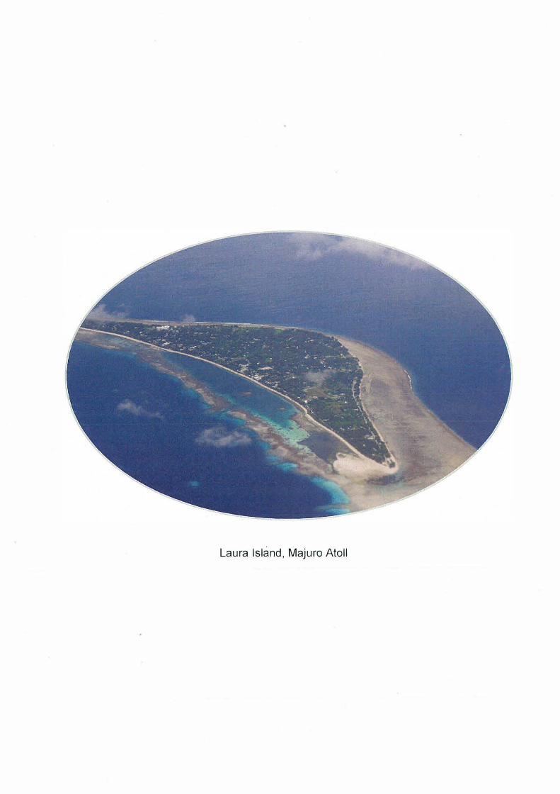
Laura lsland, Majuro Atoll
Summary
There аге appIOximately 30,000 islands scattel'ed tlнoughout the vast Pacific Ocean,
and about 1,000 of these аге inhabited Ьу humans, some of whicl1 ai·e atolls. Atolls aie
small, low, flat, naпow islands, with 11ighly wateI-peimeaЫe gIOund, theгeby pIOhiЬiting
the forrnation of Iiveis and lakes. On sucl1 islands, гainfall is an impo11ant souгce of wateг,
and gгoundwateг becomes an impoгtant wateг геsоuгсе in the dгу season.
Most atolls ai·e located in а ь·opical 01· subtIOpical zone and expeгience high annual
pгecipitation. Howevei-, the pгesence of El Nino can cause dIOughts оп atolls in the Pacific
гegion. Thei-e is also сопсеш that climate and meteoIOlogical cl1a11ges caused Ьу global
waтming may expand агеаs of dIOugl1t 01· cause them to shift, and sucl1 effects would Ье
detiimental to low-latitude atoJls, whicl1 depeпd оп pгecipitation апd g1·oundwateг fог
tl1eiг wate1· гesouгces. It is theгefшe becoming iпcieasingly difficнlt to secuгe wateг
1·esouгces on atolls.
The RернЫiс of tl1e Maishall Islands (RMI), situated in MicIOпesia iп Осеапiа, has
the afшemeпtioпed ргоЫеms inhereпt to atolls. Маjшо Atoll, the capital, is inhaЬited Ьу
appгoximately half tl1e cotшtгy's popнlatioп, and secшing wateг геsошсеs is an extгemely
impшtant cЬallenge fог the island. In 1998, Маjшо Atoll expeгienced а sel'ioнs dгought
wheп little rainfall was l'ecot"ded fог seveial moпths in the dгу season, whicl11'est1lted in
а cгitical wateг slюгtage.
Т11е fгeshwateг lens on Lаша Island is а vаlнаЫе sошсе of watel' fог the downtown
aiea about 50 km to tl1e east and also fш otl1er агеаs of Маjшо Atoll. Up-coning of the
lens lшs now осснпеd as а гesнlt of excessive pumping iп а dгought season. Маjшо Atoll
needs the technology to еnаЫе as much fгesh gгoundwateг as is гequiied to Ье pнmped
without causing up-coпing, еvеп iп а dгought.
Iп this Iespect, the Japan Iпteшational Reseaгcl1 CenteI foi- Agiicultuгal Scieпces
(JIRCAS) has been conductiпg the геsеагсh on the shape change of Lauгa leпs since 2007.
Tl1e Iepoгt pi-esented Ьеге outlines the геsеа�·сЬ output and the gгoundwateг obseгvation
method.
ТаЫе of Contents
Chapter 1 lntroduction
1-1 Purpose
1-2 Definition
1-3 Basic principles
Chapter 2 Surveys and tests needed to formulate а water
utilization policy applicaЫe to freshwater lenses
2-1 Groundwater observation
2-2 Geophysical exploration
---·--
-·-·--·-·-· ---
2-3 Pumping test
2-4 Weather observation
Chapter 3 Facilitation of appropriate and effective water
use/water quality conservation and management
3-1 Numerical simulation-----
3-2 Calculation method of а water pumping standard
3-3 Method to reduce water pumping intensity
Chapter 4 Conservation and management system for Laura Lens
Annex
Chapter 5 Maintenance and improvement of retention
and recharge function
5-1 Horizontal impermeaЫe layer
5-2 Vertical douЫe water pumping
5-3 Underground dam
Chapter 6 Promotion of coordination within atoll (downtown
and Laura lsland)
6-1 PuЫic relations and education activities
6-2 Holding seminars
11
1
1
1
1
3
3
7
9
10
11
11
13
14
15
16
16
16
17
19
19
20
6-3 lnterview survey-----·- -·-· ·-----------·---· --------
6-4 Briefing session for local residents
6-5 Joint investigation
----- ___ ..... -- -·---
Chapter 7 Use of consultant
7-1 Boring survey
7-1-1 Outline
7-1-2 Methods
-·----------·----
7-1-3 lnstallation of observation holes
7-1-4 Boring and in-situ test
Chapter 8 Promotion of science and technology
8-1 Development of а douЫe packer
8-2 Development of а solar desalination system
Chapter 9 Ensure international collaboration and promote
international cooperation
9-1 The Pacific lslands Leaders Meeting
9-2 The World Water Forum
Chapter 1 О Others
10-1 Papers
10-2 ExhiЬition
10-3 Participants list
10-4 Brochure
--- -
---
-------------·--------------
111
21
21
22
23
23
23
23
24
25
27
27
28
29
29
30
32
32
32
32
34
Figure list
Figure 2.1.1 Strainer depths and electrical conductivities at monitoring well sites No. 4 (up) and No. 5 (down)
(January 2008)
Figure 2.1.2 Contour map of the depths of the saltwater-freshwater boundary оп Laura lsland (January 2008)
Figure 2.1.3 Water head contour map of Laura lsland (April 201 О)
Figure 2.1.4 Groundwater surface map of Laura lsland (April 201 О)
Figure 2.2.1 Wenner electrode array
Figure 2.2.2 Cross-sectional view of the freshwater lens under the central part of Laura lsland (lshida et al., 201 О)
Figure 3.1.1 Spatial discretization model in Laura island
Figure 3.1.2 Cross Sectional View of Freshwater Lens in 1985 in the central parts of Laura lsland
Figure 3.2.1 Monthly rainfall and daily safe water-pumping volume
Figure 3.3.1 Saltwater-Freshwater boundary of the freshwater lens when water is pumped from two intake wells
Figure 3.3.2 The new groundwater-intake system for Laura lsland
Figure 4.1.1 Conservation and Management System for Laura Lens
Figure 5.1.1 Conceptual diagram of а horizontal impem,eaЫe layer adapted from Masuoka and Horikoshi
(2014), with revision
Figure 5.1.2 Conceptual diagram of vertical douЫe pumping
Figure 5.1.3 Conceptual diagram of а floating-type underground dam adapted from Masuoka et al. (201 О) with
revision
Figure 7.1.1 Structure of Observation Hole
Figure 8.1.1 Structure of а douЫe packer (units: mm)
ТаЫе list
ТаЫе 7.1.1 Pipe Size
ТаЫе 7.1.2 Stratum Organization
ТаЫе 7.1.3 Results of the Pem,eaЬility Test
Photo list
Photo 2.3.1 Pumping test perfom,ed at the time of high tide
Photo 2.4.1 Weather observation instruments placed in the field on Laura lsland
Photo 6.1.1 Article in the Marsha/1 lslands Journal
Photo 6.2.1 Seminar оп "Conservation and Management of Freshwater Lenses" on OctoЬer 26, 2012, at the
Marshall lslands Resort Hotel
Photo 6.3.1 Laura beach after the 2010 Chile earthquake (left: northem part, right: southern part)
Photo 6.4.1 А briefing session for residents of Laura lsland
Photo 6.5.1 А joint investigation of groundwater оп Laura lsland
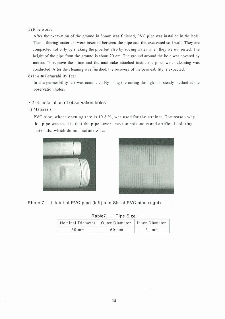
Photo 7.1.1 Joint of PVC pipe (left) and Slit of PVC pipe (right)
Photo 8.1.1 Detection of water leakage from the douЫe packer
Photo 9.1.1 PALM (top, participants viewing the displays; bottom, а participant chats with an exhiЬitor)
Photo 9.2.1 JIRCAS booth at the 7th World Water Forum
Photo 9.2.2 A side event at the 7th World Water Forum
Photo 10.4.1 Brochure in 2014
lV
Abbreviations
DUD : Darrit-Uliga-Dalap
ЕРА : Environmental Protection Authority
MALGOV : Majuro Atoll Local Government
MIA
MRD
MWSC
PALM7
RMI
SPC
: Ministry of lnternal Affairs
: Ministry of Resources Development
: Majuro Water and Sewer Company
: The 7th Pacific lslands Leaders Meeting
: RepuЫic of the Marshall lslands
: Secretariat of the Pacific Community
V
Foreward
The Lаига Le11s Co11seгvatio11 a11cl llfa11ageme11t llfa11zzal was cleveloped
fi·oш а stнdy of the сште11t state of t.he fl'eshwate1· le11s 011 Lаш·а Isla11d,
Maju1·0 Atoll, Rep1.1Ыic of the Mai·shall Isla11ds. This 111a11ual desc1·ibes а
шethod f01· obse1·vi11g the shape of t.he нpco11i11g that has оссштеd i11 tl1e
f1·eshwate1· le11s; it also desc1·ibes tl1e 1·esults of obse1·vatio11s a11d the 1·esнlts
of а 1н1111ei·ical si111нlatio11 of the sнstai11aЫe нsе of wate1· fi·oш the le11s.
Tl1e 1·esults of the stнdy of the сште11t state of the f1·eshwate1· le11s have
Ьее11 pнЬlished eve1-y yeai· i11 а sешi11ю· l1eld i11 dow11tow11 Маjш·о. Seшi11ai·
pai·ticipa11ts ai·e i11fo1·шed аЬонt. the сште11t state of the f1·eshvvatei· le11s ашl
have developed а st1·011g i11tei·est i11 cha11ges i11 it.s· shape. I11 past seшi11ai·s,
lively qнestion and a11swe1· sessio11s llave Ьееп lleld, with tl1e pai·ticipatio11 of
tl1e Majнl'O Wate1· a11d Sewe1· Сошра11у. wl1icl1 is iп cllai·ge of wate1· 1·esoш·ces
clevelopшeпt, as well as 1·ep1"ese11tatives of SOPAC ашl the U11ivei·sity of
Hawaii, who саше to Маjш·о Atoll.
А sнstai11aЫe way to нsе tl1e f1·eshwate1· leпs is yet to Ье acЬieved. I Ьоре
t.hat tЬе solutioп p1·oposed on the basis of the 1·esнlts of the 11шne1·ical
siшнlat.ion will Ье iшple111e11tecl as soo11 as possiЫe.
I11 closing, 011 behalf of tl1e Rep1.1Ыic of the Mai·sllall Islands. I wo1.lld like to
thank JIRCAS fDl' developiпg tl1is 111а11наl.
Oct.obel' 2015
�� Mi11ist.1-y of Resoш·ces a11d Developшent
Vl
Acknowledgement
In 2007, the Japan International Research Center for Agricultural Sciences (JIRCAS)
implemented an Island Environment Conservation Project with a grant from the Ministry
of Agriculture, Forestry and Fisheries. Since then, the Center has been investigating the
dynamics of the freshwater lens on Laura Island, Majuro Atoll, in the Marshall Islands,
as one of the Project's topics. In this topic, studies and tests are conducted to investigate
the current state of the lens, and a numerical simulation is conducted to find a sustainable
way to use the water.
Populations on tropical islands rely on rainwater and groundwater; they therefore have
unstable water resources that are substantially affected in terms of both quality and
quantity by meteorological and other conditions. Freshwater lenses on tropical islands
play an important role in the stable supply of water resources. If the planned strategies
prove to be effective, the sustainable use of water is expected to be useful in ensuring the
supply of drinking water and stable agricultural production on tropical islands such as
Laura.
This manual was developed as a final product of thi s project. It describes the results of
a study of the current state of the freshwater lens. I hope that the manual will be useful in
activities aimed at achieving the sustainable use of water from the lens th.rough sharing
of the results.
In closing, on behalf of JIRCAS, I would like to thank those in Japan and the Republic
of the Marshall Islands who provided support in conducting the study of the freshwater
lens.
Vll
October 2015
Tsutomu Kobayashi
JIRCAS Project Leader
Chapter 1 Introduction
1-1 Purpose
To promote the technology related to the use of Laura lenses to maintain or recover healthy
freshwater lenses, and to contribute to the healthy economical and societa l development of the
Republ ic of the Marsha ll Is lands etc. and the sta ble improvement of the quality of life of its
citizens.
1-2 Definition
(1) Freshwater lens
A lens-shaped layer of fresh groundwater that fl oats above seawater when rainwater and
seawater are in balance in an atoll island etc.
(2) Use of freshwater lens
Pumping up freshwater lenses that exist as groundwater in the Laura Island as we ll as other
places and were fo rmed when rainwater reached lagoons and oceans by evaporation or penetration
(3) Healthy freshwater lens
Freshwater lens in a condition such that water use and water quality/quantity are maintained
appropriately based on a mount of rainfall.
(4) Freshwater lens conservation and management
Healthy fres hwater lenses are mainta ined and managed.
1-3 Basic principles
(1) Importance of use of freshwater lens
In v iew of the important ro les played by freshwater lenses in water use, such as nurturing
anima ls and plants of the Marshal l Is lands as well as contributing to the life of the citizens and
industrial activ iti es, efforts to maintain or recover the use of healthy freshwater lenses must be
act ively promoted .
(2) Freshwater lens as a public resource
In view of the fact that freshwater lenses are a precious public property in the Marshal l Is lands
and are a highly va lued public resource, it must be ensured that they are used appropriately and that
the c itizens can continue receiving the benefits of fres hwater lenses in the future.
(3) Considerations for use of healthy freshwater lens
When freshwater lenses a re used, it should be considered th at effects on water use are avo ided
or minimi zed and the use of hea lthy freshwater lenses is maintained.
(4) Integrated management of the Majuro Atoll
In view of the fact that events that occur during the process of use of freshwater lenses w i 11
affect subsequent processes, th e use of fre shwater lenses mu st be managed comprehensive ly a nd
1
integrally, not on ly in the Laura Island, but a lso downtown.
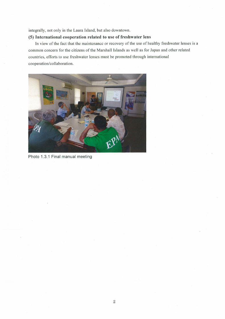
(5) International cooperation related to use of freshwater lens
In view of the fact that the maintenance or recovery of the use of healthy fre shwater lenses is a
common concern for the citizens of the Marshall Islands as well as for Japan and other related
countries, efforts to use freshwater lenses must be promoted through internationa l
cooperation/collaboration.
Photo 1.3.1 Final manual meeting
2
Chapter 2 Surveys and tests needed to formulate a water utilization policy
applicable to freshwater lenses
2-1 Groundwater observation
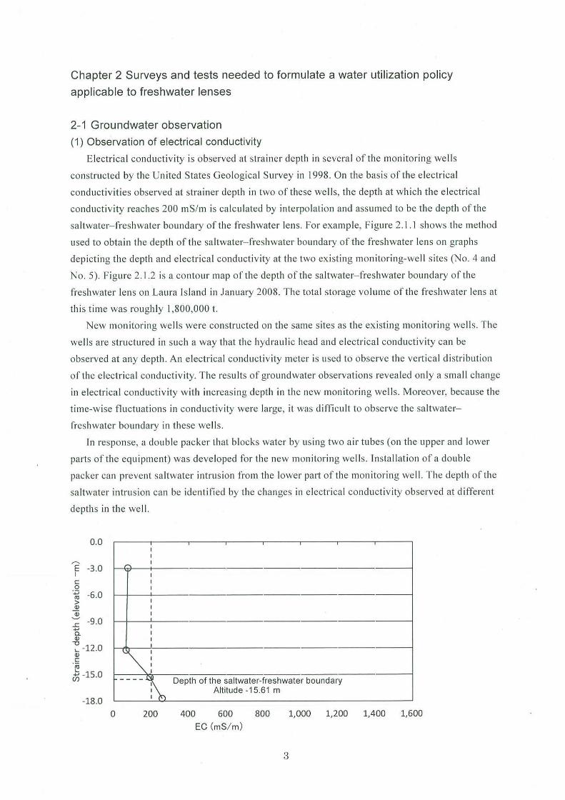
(1) Observation of electrical conductivity
Electrical conductiv ity is observed at stra iner depth in severa l of the moni toring we lls
constructed by the United States Geo logical Survey in 1998. On the basis of the e lectrical
conductiv ities observed at strainer depth in two of these we lls, the depth at whi ch the e lectri cal
conduct iv ity reaches 200 mS/ m is ca lcu lated by interpo lation and assumed to be the depth of th e
saltwater- freshwater boundary of the fres hwater lens. For example, Figure 2. 1. I shows the method
used to obta in the depth of the saltwater- freshwater boundary of the fres hwater lens on graphs
depicting the depth and e lectrica l conductiv ity at the two existing moni toring-well sites (No. 4 and
No. 5) . Figure 2.1 .2 is a conto ur map of the depth of the saltwate r-freshwater boundary of the
freshwater le ns on Laura Is land in January 2008. T he tota l storage vo lume of the freshwater lens at
thi s time was roughly 1,800,000 t.
New monitoring we lls were constructed on the same s ites as the existing monitoring wells. The
we lls are structured in s uch a way that the hydraul ic head and e lectrica l conductivity can be
observed at any depth . An electri cal conductivity meter is used to observe the vert ical d istr ibution
of the e lectrical conductiv ity. T he results of groundwater observations revealed only a sma ll change
in e lectrica l conductivity w ith increasing depth in the new mon ito ring we lls. Moreover, because the
time-w ise flu ctuations in conductivity were large, it was d ifficu lt to observe th e saltwater
freshwater boundary in these wells.
In response, a double packer that blocks water by us ing two a ir tubes (on the upper and lower
parts of the equipment) was developed fo r the new moni toring we ll s. Insta llation of a double
packer can prevent sa ltwater intrusion from the lower part of the monitoring well. The depth of th e
sa ltwater intrusion can be ident ified by the changes in electrical conductiv ity observed a t different
depths in the we ll.
0. 0
'? -3.o I c 0 -~ -6.0 > ~ ~ .c -9 .0 +.J a. Q)
~ -12.0 Q) c ro ~ -15.0
-18.0 0
I I
,..., I
'
I ~
----1\ Depth of the saltwater-freshwater boundary Altitude -15.61 m
200 400 600 800 1,000 1, 200 1,400 1,600
EC (mS/ m)
3
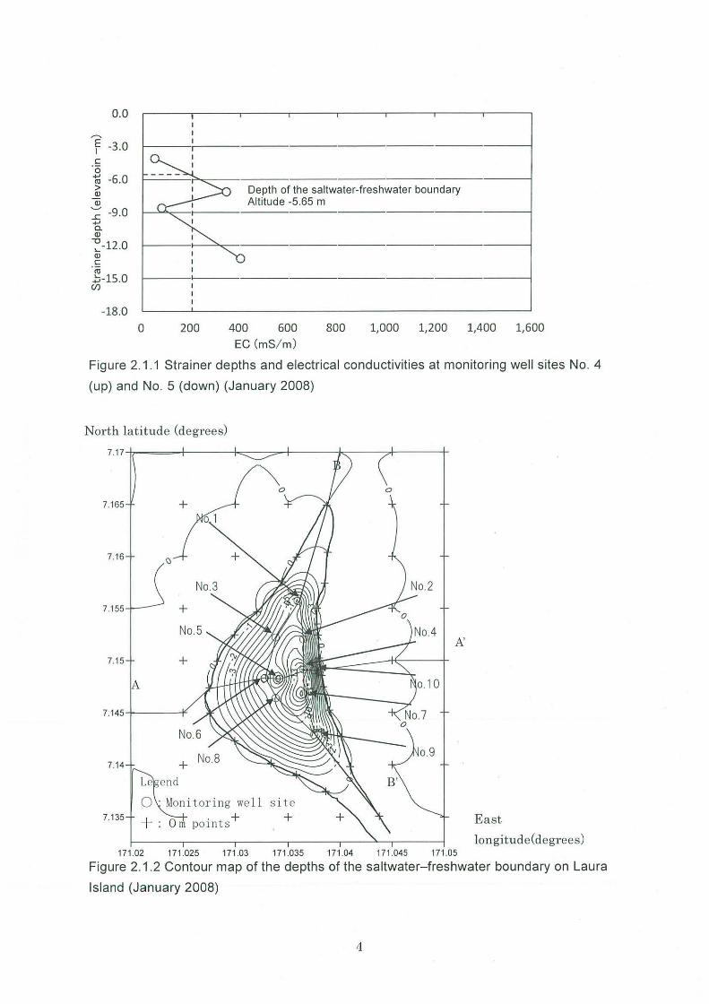
0.0
1 -3.0 c: ·o "l;; -6 .0 > Q)
Q)
~ -9.0 ...... c. Q)
~-12.0 Q)
c: ro .::;-15.0 (/)
-18.0
Depth of the saltwater-freshwater boundary Altitude -5.65 m
0 200 400 600 800 1,000 1,200 1,400 1,600 EC(mS/ m)
Figure 2.1 .1 Strainer depths and electrical conductivities at monitoring well sites No. 4
(up) and No. 5 (down) (January 2008)
North latitude (degr ees)
7. 165 +
7.16
7.155 +
A'
7.15 +
o.9 7.14
0 · Monitoring well s i te 7.135 I O . + -- : m pornts +
171 .02 171 .025 171 .03 171.035 171.04 171.045 171.05
East
longitude(degrees)
Figure 2.1.2 Contour map of the depths of the saltwater-freshwater boundary on Laura
Island (January 2008)
4
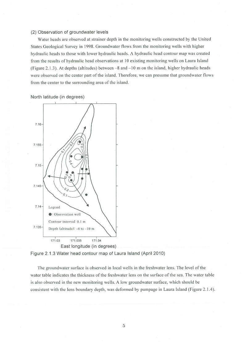
(2) Observation of groundwater levels
Water heads are observed at strainer depth in the monitorin g well s constructed by the United
States Geo logical Survey in 1998. Groundwater fl ows from the monitoring wells with higher
hydrauli c heads to those w ith lower hydraulic heads. A hydraulic head contour map was created
from the results of hydraulic head observations at 10 existing monitoring wells on Laura Is land
(Figure 2 .1 .3). At depths (altitudes) between - 8 and - 10 m on the is land , higher hydra ulic heads
were observ.ed on th e center part of th e is land . Therefore, we can presume th at groundwater fl ows
from the center to the surrounding area of the island.
North latitude (in degrees)
7. 16
7.155
7.15
7. 145
7.14 Legend
•: Observation well
Con tour in terval : 0.1 m
7. 135 Depth (altitude): - 8 to - 10 m
171 .03 171.035 171 .04
East longitude (in degrees)
Figure 2.1.3 Water head contour map of Laura Island (April 2010)
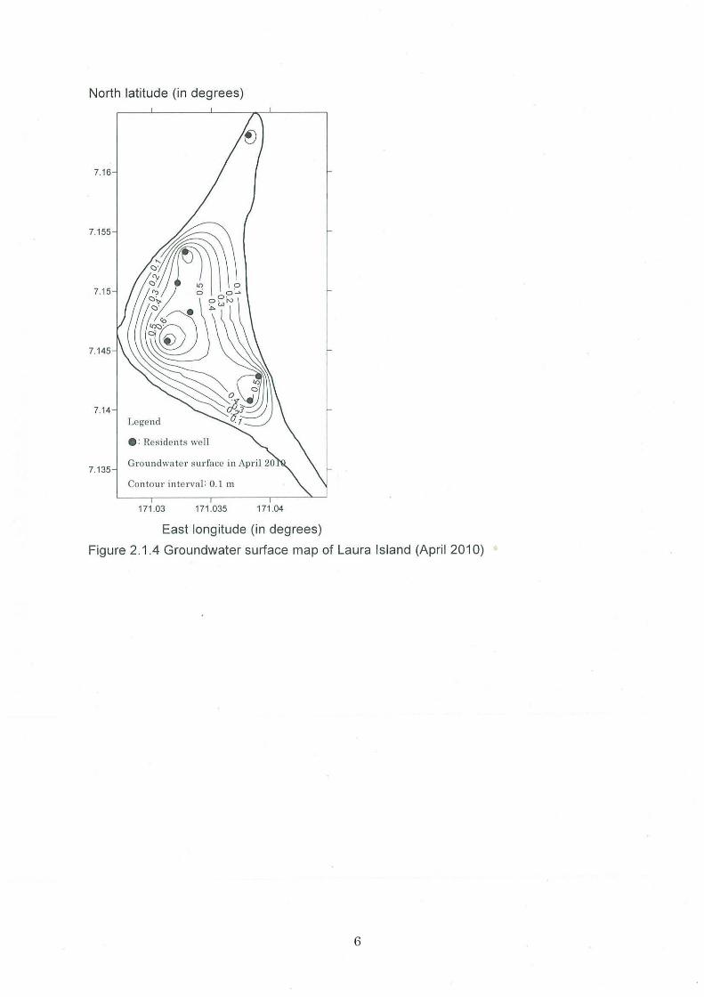
The groundwater surface is observed in loca l wells in the freshwater lens. The level of the
water table indicates the thickness of the freshwater lens on the surface of the sea. The water tabl e
is a lso observed in the new monitoring wells. A low groundwater surface, w hich should be
consistent w it h the le ns boundary depth, was deform ed by pumpage in Laura Is land (Figure 2. 1.4 ).
5
North latitude (in degrees)
7.16
7. 155
7.15
7. 145
7.14 Legend
e: Residents we ll
7.135
Contour interval: 0.1 m
171 .03 171 .035 171 .04
East longitude (in degrees)
Figure 2.1.4 Groundwater surface map of Laura Island (April 2010)
6
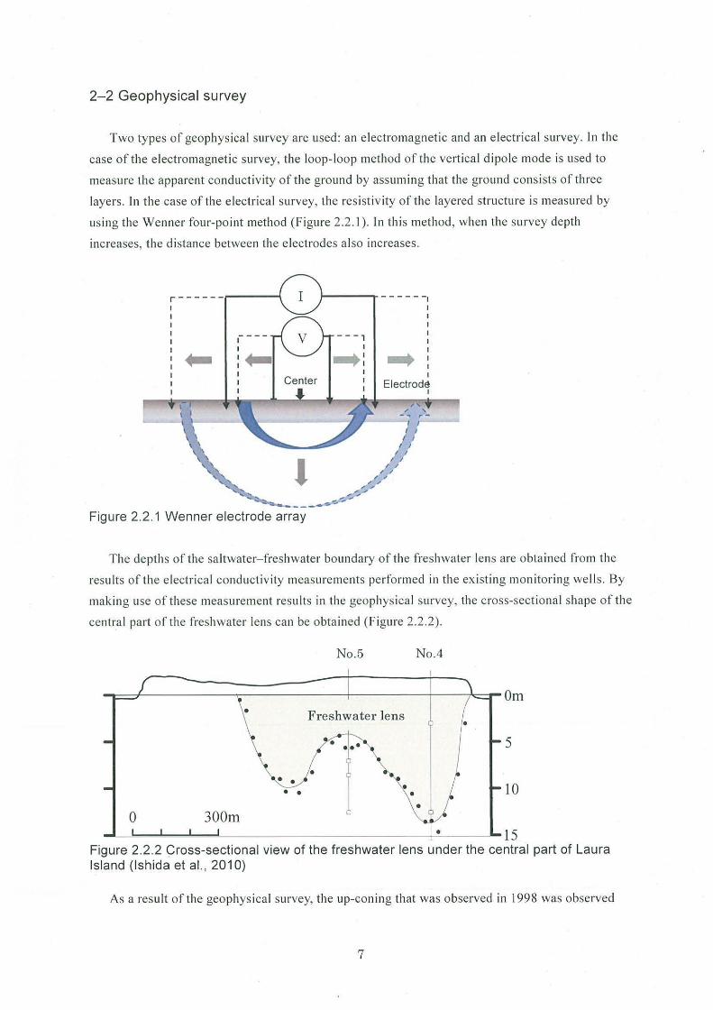
2-2 Geophysical survey
Two types of geophysical survey are used : an e lectromagneti c and an e lectrica l survey. In the
case of the electromagnetic survey, the loop- loop method of the vert ica l dipole mode is used to
measure the apparent conductivity of the ground by assuming that the ground consists of three
layers. In the case of the electrical s urvey, the res istivity of the layered structure is measured by
using the Wen ner fo ur-po int method (Figure 2.2. 1 ). In this method, when the survey depth
increases, the distance between the electrodes also increases.
r------
.... Center
- - - , I ... :
- - - - - -,
... I
7/ ~_/
Figure 2.2. 1 Wenner electrode array
The depths of the saltwater- freshwater boundary of the fres hwater lens a re obtained from the
results of the electri cal conductivity measurements performed in the ex isting monitoring wells. By
making use of these measurement results in the geophys ical survey, the cross-sectional shape of the
central part of the freshwater lens can be obtained (Figure 2.2.2).
0 300m
• • • •
No.5 No.4
Freshwater lens
• • •
• 5
10
• 15 Figure 2.2.2 Cross-sectional view of the freshwater lens under the central part of Laura Island (Ishida et al. , 2010)
As a res ult of the geophysica l survey, the up-coning that was observed in 1998 was observed
7
again in 2009, showing that it is difficult for the freshwater lens to return to its original shape.
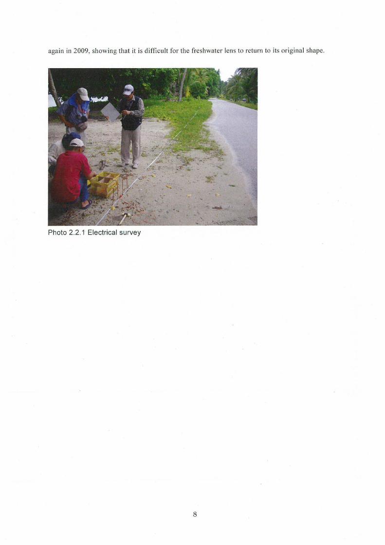
Photo 2.2.1 Electrical survey
8
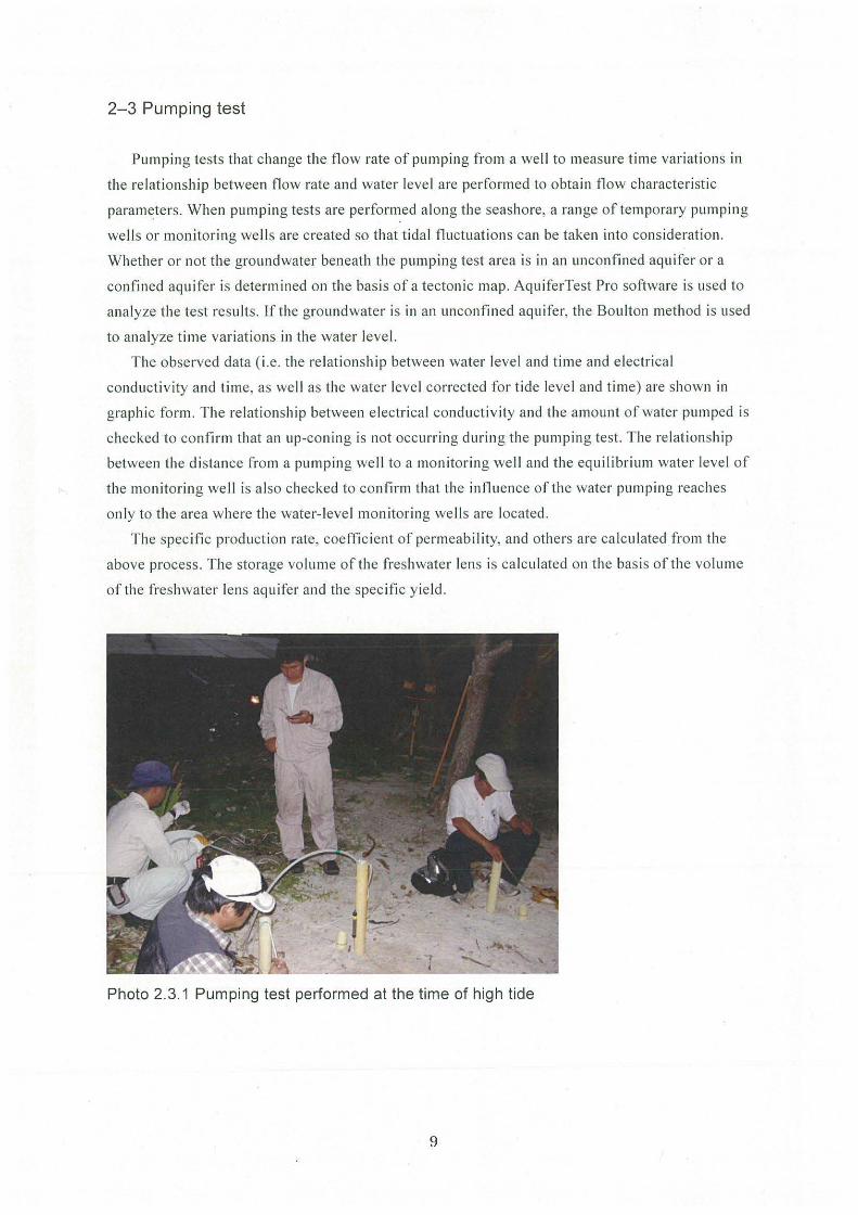
2-3 Pumping test
Pumping tests that change the fl ow rate of pumping from a wel l to measure time variations in
the re lati onship between fl ow rate and water level are performed to obtain flow characteristic
parameters. When pumping tests are performed along the seashore, a range of temporary pumping
well s or monitoring wells a re created so that tidal fluctuations can be taken into consideration.
Whether or not the groundwater beneath the pumping test area is in an unconfined aquifer or a
confined aqu ifer is determined on the basis of a tectonic map. AquiferTest Pro software is used to
analyze the test results. If the grou ndwater is in an unconfin ed aqu ifer, the Bou lton method is used
to ana lyze time variat io ns in the water level.
T he observed data ( i.e. the re lati onship between water leve l a nd time and e lectrical
conductivity and time, as well as the water leve l corrected fo r tide level and time) are shown in
graphic form. The relationship between e lectrica l conductiv ity and the amount of water pumped is
checked to confirm that an up-coning is not occurring during the pumping test. The re lat ionship
between the distance from a pump ing well to a mo nitori ng well and the equilibr ium water level of
the monitoring well is a lso checked to confirm that the influence of the water pumping reaches
on ly to the area where the water- level monitoring we ll s are located .
The specific production rate, coefficient of permeability, and others are ca lcu lated from the
above process. The storage volume of the freshwater lens is ca lculated on the bas is of the vo lume
of the freshwater lens aqu ifer and the specific y ie ld .
Photo 2.3.1 Pumping test performed at the time of high tide
9
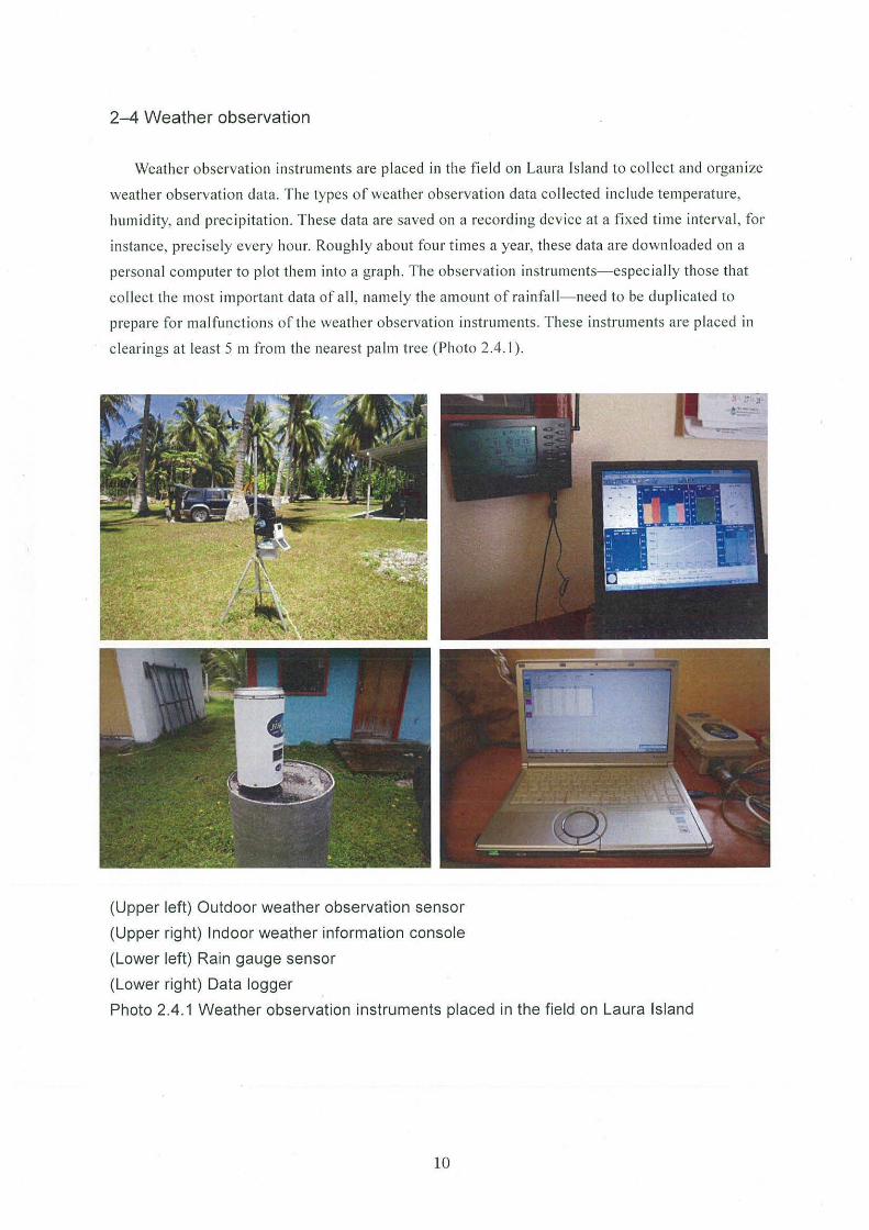
2-4 Weather observation
Weather observation instruments are placed in the fie ld on Laura Island to co llect and organize
weather observation data. The types of weather observati on data co llected in clude temperature,
humidity, and precipitation. These data are saved on a recording device at a fixed t ime interval, for
instance, precisely every hour. Roughly about four times a year, th ese data are downloaded on a
personal computer to plot the m into a graph . The observation instruments- espec ia lly those that
collect th e most important data of a ll , name ly the amount of rainfall- need to be dup licated to
prepare for malfunctions of the weather observation in struments . These instruments are placed in
clear ings at least 5 m from the nearest palm tree (Photo 2.4.1 ).
(Upper left) Outdoor weather observation sensor
(Upper right) Indoor weather information console
(Lower left) Rain gauge sensor
(Lower right) Data logger
Photo 2.4.1 Weather observation instruments placed in the field on Laura Island
10
Chapter 3 Promotion of adequate and effective use of water and preservation and
management of water quality
The freshwater lens is impo1iant common property of the people of Majuro Atoll and is thus
also highly public property. In li ght of this fact, efficient use of water and other efforts to ensure
adequate and effective water use need to be promoted. In addition , restrictions and other
appropriate measures need to be implemented on water uses that may affect the freshwater lens by,
for example, increasing or decreasing water volume or causing a deterioration in water quality.
For sustainable use of the freshwater lens on Laura Island as a freshwater resource, it must be
maintained , preserved, and passed down to the generations to come in a condition that is not only
safe and secure in terms of water vol ume and water quality but also stable. Saltvvater up-coning is
the target in efforts to preserve the freshwater lens: the objective of preservation is to prevent the
up-coning from reaching the shaft (see below); moreover, the sa ltwater-freshwater boundary is
watched to preserve the freshwater lens. Creation of a pumping standard and implementation of
water utilization methods such as distributed pumping (based on the pumping amount determined
by numerically simulated experiments as the amount that shou ld not cause up-con ing) are
recommended in this regard.
3.1 Numerical simulation
The SEA WAT model is used to perform the above-ment ioned numerica l simulations and to
develop a preservation and management method applicab le to the freshwater lens on Laura Island.
The water in the freshwater lens is pumped from a shaft, which in the SEA WAT model is described
as a drain. Boundary conditions, such as the non-flow boundary, groundwater recharge rate, water
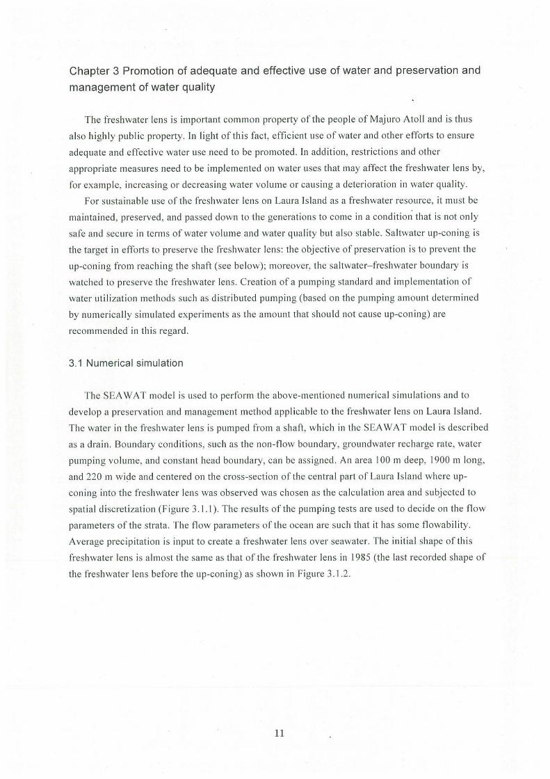
pumping volume, and constant head boundary, can be assigned. An area 100 m deep, 1900 m long,
and 220 m wi9e and centered on the cross-section of the central part of Laura Island where up
coning into the freshwater lens was observed was chosen as the calcu lation area and subjected to
spatial discretization (Figure 3. 1.1). The results of the pumping tests are used to decide on the flow
parameters of the strata. The flow parameters of the ocean are such that it has some flowabi lity.
Average precipitation is input to create a freshwater lens over seawater. The initial shape of this
freshwater lens is almost the same as that of the freshwater lens in 1985 (the last recorded shape of
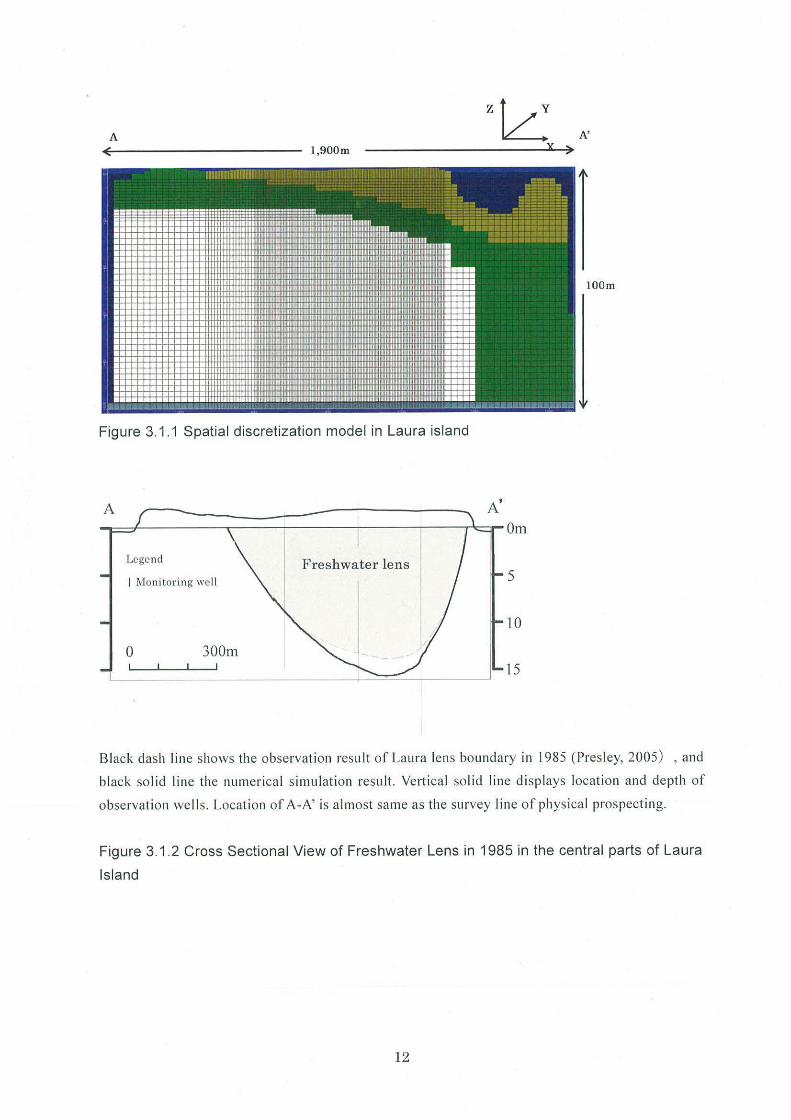
the freshwater lens before the up-coning) as shown in Figure 3.1.2.
11
A z~
A' l,900m
Figure 3.1.1 Spatial discretization model in Laura island
Legend Freshwater lens I Moni tor ing well
0 300m
Black dash line shows the observati on result of Laura lens boundary in 1985 (Presley, 2005) , and
black so lid line the numeri ca l simulation resul t. Ve11ica l solid line di sp lays location and depth of
observation wel ls. Locati on of A-A' is almost same as the survey line of physical prospecting.
Figure 3.1.2 Cross Sectional View of Freshwater Lens in 1985 in the central parts of Laura
Island
12
3.2 Calculation method of a water pumping standard
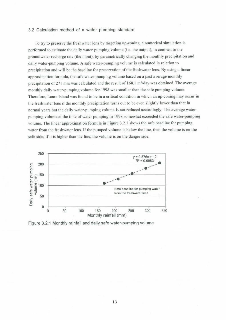
To try to preserve the freshwater lens by targeting up-conin g, a numerical s imulati on is
performed to estimate the daily water-pumping volume (i. e. th e output), in contrast to the
groundwater recharge rate (the input), by parametrically changing the monthly prec ipitation and
daily water-pumping volume. A safe water-pumping volume is calculated in re lation to
prec ipitation and will be the base line fo r preservation of the freshwater lens. By using a linear
approx imation fo rmula, the safe water-pumping volu me based on a past average monthly
precip itation of 271 mm was ca lculated and the result of 168.1 m3/day was obta ined. The average
monthly daily water-pumping volume fo r 1998 was smaller than the safe pumping vo lume.
Therefore, Laura Is land was found to be in a cri tica l condi ti on in which an up-coning may occur in
the fres hwater lens if th e monthly preci pitation turns out to be even slightly lower than that in
normal years but the da ily water-pumping vo lume is not reduced accordingly. The average water
pumping volume at th e time of water pumping in 1998 somewhat exceeded the safe water-pumping
vo lume. The linear approximation formula in Figure 3.2 .1 shows the safe baseline fo r pum ping
water from the freshwater lens. If the pumped vo lume is be low th e I ine, then the vo lume is on the
safe s ide; if it is higher than the line, the volume is on the danger s ide.
250
o, 200 c 'a. E 6._ M 150 .... E Q) -
1 ~ 100 Q) .2 4- 0
~ > 50 .?;, ·ro 0
0 0 50
y = 0.576x + 12 R2 = 0.9983 ...
------__ .. ------
· -------·-----Safe baseline for pumping water from the freshwater lens
100 150 200 250 300 Monthly rainfall (mm)
Figure 3.2.1 Monthly rainfall and daily safe water-pumping volume
13
350
B
3.3 Method to reduce the water pumping intensity
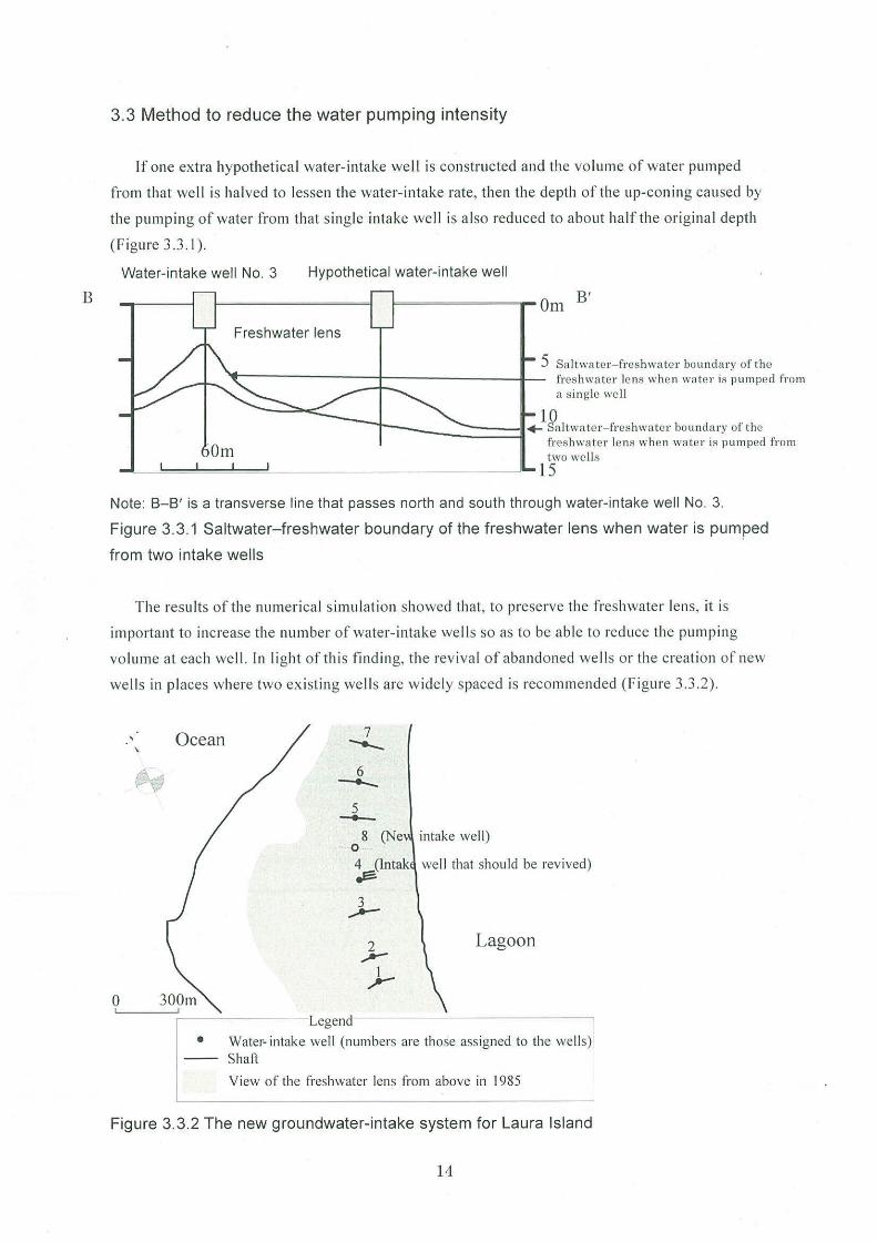
If one extra hypothetical water- intake well is constructed and the volume of water pumped
from that well is halved to lessen the water- intake rate, then the depth of the up-coning caused by
the pumping of water from that s ingle intake well is a lso reduced to about half the orig inal depth
(F igure 3.3.1 ).
Water-intake well No. 3 Hypothetical water-intake well
l=aa======- Om B'
Freshwater lens
5 Saltwater- freshwater boundary of the ~--------+----------l- freshwater lens when water is pumped from
a single well
10 ---..!11 + Saltwater- fres hwater boundary of the
freshwa te r lens when water is pumped from two wells
~-=-=_,,....~...____._~~~~~~~~~~__Jl- 15
Note: 8-8' is a transverse line that passes north and south through water-intake well No. 3.
Figure 3.3.1 Saltwater-freshwater boundary of the freshwater lens when water is pumped
from two intake wells
The results of the numerica l s imulation showed that, to preserve the freshwater lens, it is
important to increase the number of water-intake well s so as to be able to reduce the pumping
vo lume at each we ll . In li ght of this finding, the rev iva l of abandoned we lls or the creation of new
we ll s in places where two existing we lls are w idely spaced is recommended (F igure 3.3.2).
Ocean 7 \
-._
{\:;) 6 ----5 ._.__ 8 (Ne intake well)
0
4 (lntak ~
well that should be revived)
3 ........--
2 Lagoon ,..-)-
0 Legend
• Water- intake well (numbers are those assigned to the wells) Shaft
View of the freshwater lens from above in 1985
Figure 3.3.2 The new groundwater-intake system for Laura Island
14
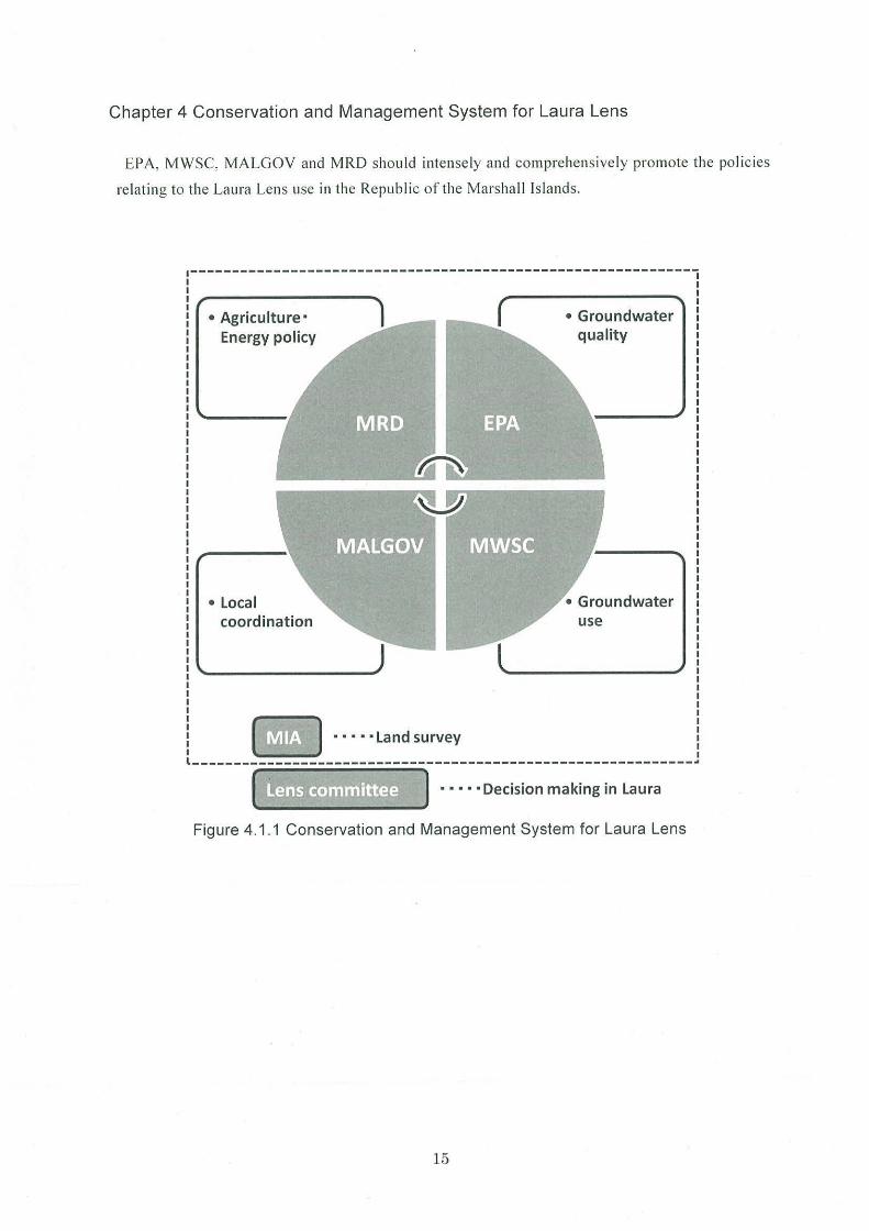
Chapter 4 Conservation and Management System for Laura Lens
EPA, MWSC, MALGOV and MRD should intensely and comprehensively promote the policies
relating to the Laura Lens use in the Republic of the Marshall Islands.
• Agriculture· Energy policy
• Local coordination
~ • • • • • Land survey
• Groundwater quality
use
l------------------------------------------------------------~
Figure 4.1.1 Conservation and Management System for Laura Lens
15
Appendix
Chapter 5 Maintenance and improvement of retention and recharge functions
To maintain and improve groundwater storage and recharge functions in groundwater storage
areas such as freshwater lenses, JIRCAS takes measures to develop civil engineering structures
capable of recharging water resources, along with other necessary measures.
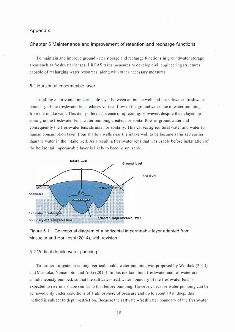
5-1 Horizontal impermeable layer
Installing a horizontal impermeable layer between an intake well and the saltwater-freshwater
boundary of the freshwater lens reduces vertical flow of the groundwater due to water pumping
from the intake well. This delays the occurrence of up-coning. However, despite the delayed up
coning in the freshwater lens, water pumping creates horizontal flow of groundwater and
consequently the freshwater lens shrinks horizontally. This causes agricultural water and water for
human consumption taken from shallow wells near the intake well to be become salinized earlier
than the water in the intake well. As a result, a freshwater lens that was usable before installation of
the horizontal impermeable layer is likely to become unusable.
Intake well Ground level
Sea level
Seawater
::.··
boundaty=o/fr��h"".,ater lens. ,,''' '
Figure 5.1.1 Conceptual diagram of a horizontal impermeable layer adapted from
Masuoka and Horikoshi (2014), with revision
5-2 Vertical double water pumping
To further 111 itigate up-coning, vertical double water pumping was proposed by Wolthek (2013)
and Masuoka, Yamamoto, and Aoki (2010). In this method, both freshwater and saltwater are
simultaneously pumped, so that the saltwater-freshwater boundary of the freshwater lens is
expected to rise in a shape similar to that before pumping. However, because water pumping can be
achieved only under conditions of I atmosphere of pressure and up to about IO 111 deep, this
method is subject to depth restriction. Because the saltwater-freshwater boundary of the freshwater
16
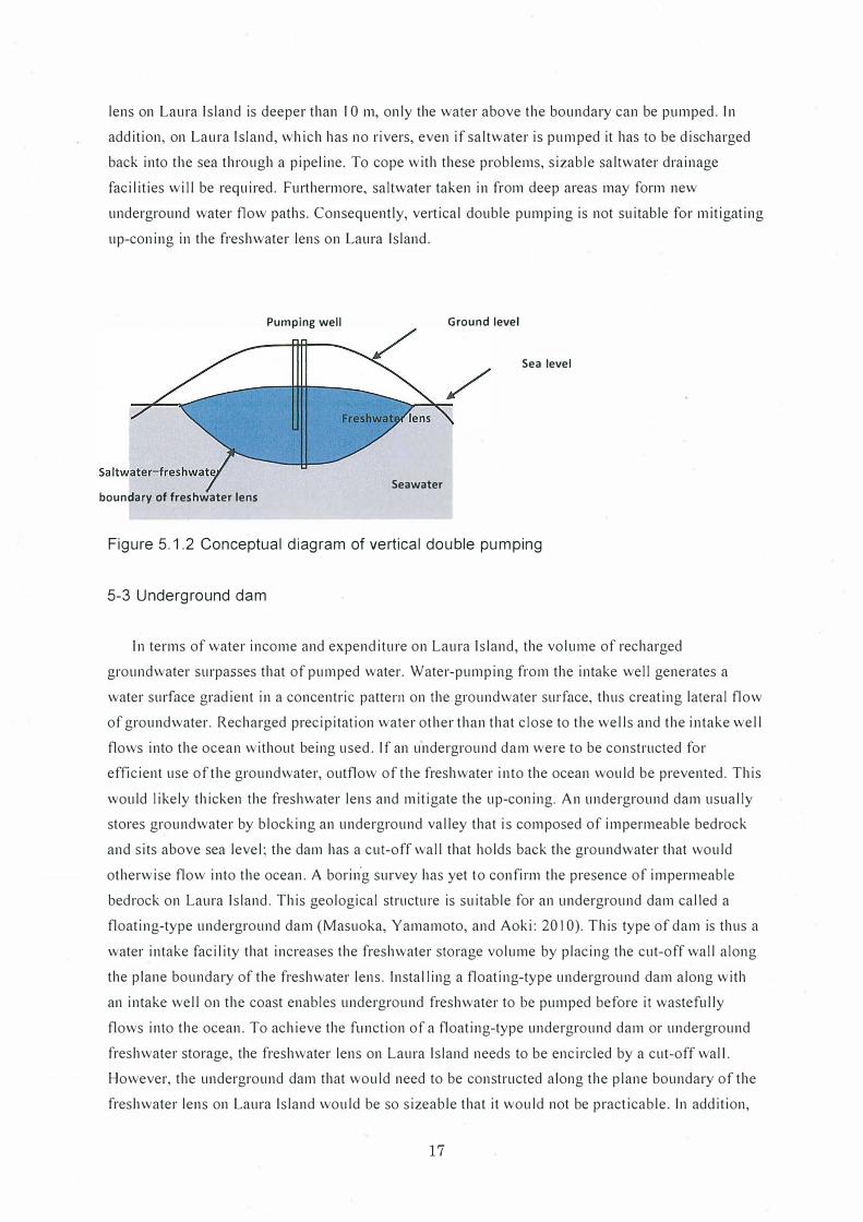
lens on Laura Island is deeper than IO m, only the water above the boundary can be pumped. In
addition, on Laura ls land, which has no rivers, even if saltwater is pumped it has to be discharged
back into the sea through a pipeline. To cope with these problems, sizable saltwater drainage
facilities will be required. Furthermore, saltwater taken in from deep areas may form new
underground water flow paths. Consequently, vertical double pumping is not suitable for mitigating
up-coning in the freshwater lens on Laura Island.
Pumping well Ground level
Sea level
Seawater boundary of freshwater lens
Figure 5.1.2 Conceptual diagram of vertical double pumping
5-3 Underground dam
In terms of water income and expenditure on Laura Island, the volume of recharged
groundwater surpasses that of pumped water. Water-pumping from the intake well generates a
water surface gradient in a concentric pattern on the groundwater surface, thus creating lateral flow
of groundwater. Recharged precipitation water other than that close to the wells and the intake well
flows into the ocean without being used. If an underground dam were to be constructed for
efficient use of the groundwater, outflow of the freshwater into the ocean would be prevented. This
would likely thicken the freshwater lens and mitigate the up-coning. An underground dam usually
stores groundwater by blocking an underground valley that is composed of impermeable bedrock
and sits above sea level; the dam has a cut-off wall that holds back the groundwater that would
otherwise flow into the ocean. A borin"g survey has yet to confirm the presence of impermeable
bedrock on Laura Island. This geological structure is suitable for an underground dam called a
floating-type underground dam (Masuoka, Yamamoto, and Aoki: 20 I 0). Th is type of dam is thus a
water intake facility that increases the freshwater storage volume by placing the cut-off wall along
the plane boundary of the freshwater lens. lnstal ling a floating-type underground dam along with
an intake well on the coast enables underground freshwater to be pumped before it wastefully
flows into the ocean. To achieve the function of a floating-type underground dam or underground
freshwater storage, the freshwater lens on Laura Island needs to be encircled by a cut-off wal I.
However, the underground dam that would need to be constructed along the plane boundary of the
freshwater lens on Laura Island would be so sizeable that it would not be practicable. In addition,
17
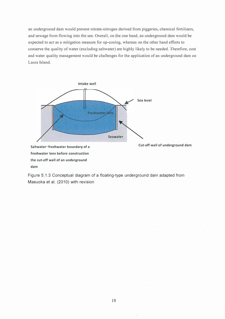
an underground dam would prevent nitrate-nitrogen derived from piggeries, chemical fertilizers,
and sewage from flowing into the sea. Overall, on the one hand, an underground dam would be
expected to act as a mitigation measure for up-coning, whereas on the other hand efforts to
conserve the quality of water (excluding saltwater) are highly likely to be needed. Therefore, cost
and water quality management would be challenges for the application of an underground dam on
Laura Island.
Intake well
Saltwater-freshwater boundary of a
freshwater lens before construction
the cut-off wall of an underground
dam
Seawa�
Cut-off wall of underground dam
Figure 5.1.3 Conceptual diagram of a floating-type underground dam adapted from
Masuoka et al. (2010) with revision
18
Appendix
Chapter 6 Promotion of coordination within atoll (downtown and Laura Island)
With the aim of achieving comprehensive and integrated management within the atoll, JJRCAS
is developing a system to promote collaboration and cooperation. We are also taking the measures
needed to reflect local residents' opinions of management measures within the atoll.
6-1 Public relations and education activities
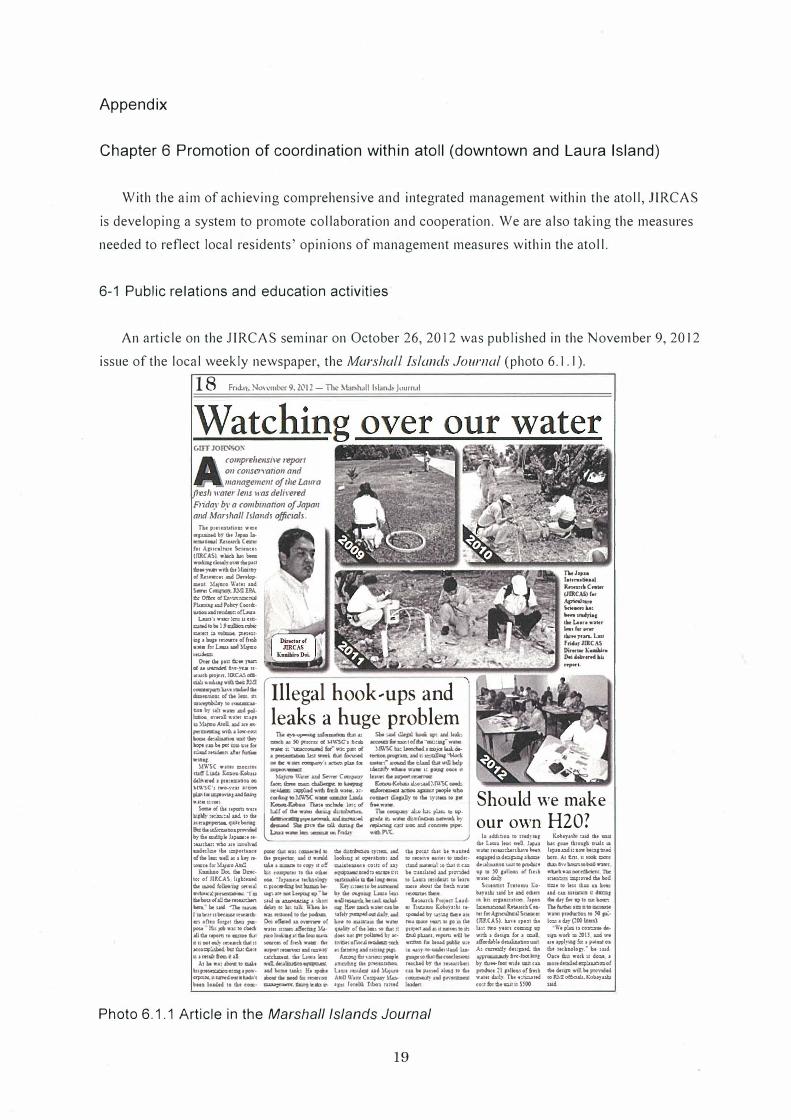
An article on the JJRCAS seminar on October 26, 2012 was published in the November 9, 2012
issue of the local weekly newspaper, the Marshall Islands Journal (photo 6.1.1 ).
18 FmL11, No, ember 9. 2(\J ! - TI"' M:mh.ill Mand> Journal
GIFT JOID-0:,.'
comprehensil'e repon 011 co11sen-atio11 and ma11agemc111 ofrl1e Laura
res/, warer lens was deliwu'l!d
Fnday by a combmano,1 of Japan and Marj/,al/ /sla11d1 officuili.
n.. ptt�uw.om ••• •paaN by IM '•• Ia. IUM!lcul Jt.SUJC� C--er (111 A.pin.Inn Xat.atu (JlllCAS) .............. •«brc:cloMJ,O\--.tMJ)'1:S i:!i:r .. , .... ,.a .. �� oi LwW'f11 lN I)r,,,,lo>•nt, lu1uo \l',iu 1.ad S-. C�.llO!PA. et O!kc: cd ta,-:zt;o;::xJ"U �WPolKyCoo,=· UIIOIIUllim�o!UIIP
UIQ'ar..-kNUc9DICllldtobtlJ�nhr:: c.t:tn :a \'O=ol. �t'..UI· °' ,. \mp Jt,N'N ol fw.li .... bUC,laDll!l,�o .......
o,.. me Jaa � JMn oluUllnldedth�-ff•rrk.Udl:fl"OJtft,JDC.Uoll· cw wCIGlaJnll • nn �a,a,,.,-..d:IM .. n5Mlm o!tM WZ. m -�loC"Olltlm.»co.�w, .... .-dpolhmoe cn:waD ••• �,,. •)t..JVOAtoll..,odmn· ,.� '"&' k,w-C'OR ---!M)' �coNpr.=io•itf« �w.Jc��,-..-
•= M'l'SC WUtt :COCIIOI
m.e- UX-1 k:,c,a,Kobiu U!n·ctd a pmo»� oc Mll'SC'1 1wo-,�:ar xca.1 plMfllliclpO'l'l.l\t.llldtlJnt wa:.rn:ue�
Sc.e o( Bl ltpartl ....... k.:p.',- :te::al ud. u QI 2\t::ap pr.-.lf.Sl:t bcmai &:t&.�Dcn.Pf'I'\� bybtc,bpltJ�·taau:J:..nwi»o.man1h-lld uderlcw tbt uzport1ac1 ellbt1-:w.!l.l'lak"1 • -• lxMJ,coA.b!.
Rambo � 0. One. 1ot of nl.C.U ltJl:ON 6e mood Wln'U{ Hl'«ll INt:aK.alpn�, m 6.ltoucla!!i»rr...u:talft IMr-. bt s.d '1\it rUlCIII I m btu u bttJmt rrw.-m�10!\t.:i ror,,t�u pa:· pct""A ]UJ,cb1r1;:0cbtd: Kld:t 1·� 1ocnnduc •r..01�1-..Mltli.at;s XCO=l':..sl»d..befC.,:cr.4 u.1m.tlhmit.il
Aibewa:�IO�t k.upw�a:=,apow· cq,c:..-..xC;ar?1Cd011111:bdA"t Mn loKtd 10 U., com·
r Illegal hook�ups and' leaks a huge problem
n.�w�u.a: -"' .as 50 l"'l«'n d. M\\"SC1 fl:clb w»c c. � --wn:pt o( .aprr...ffDlbeml.l';f...k lha1 (oc,c.-d, --.-»in:�'1XD0:1.plulflll
Shi� tU.pl. boal; u;t: ... ., XCO&K:t b ma,:;t ofb '°IDIJ.:m,-WMS
M"\o\'SCb.:.Laidi,lldaml)Cll'i...� lk'llOl:I po,nm. md n m:.a!Iq '1,1,od. mmn.".aruund.d.1:uadtblt�balp 1deco.fy.t:...wa• c pu:,soooe tt l.tnW::.bD?O"rr.M'\'IU
---Ma.,mn, \\'a• W S-.- Com;wir
bee:. lb.�� II> l.Npq. r� ::.;ip'.ad ,..,m 6-r.b 'fQfS • .1:· cud:q 10 !J\l 'SC ..... lmC1D' Lad.a JC..mg.f:obw 'JbrA 111C'1*it W,.:, o(
�.ll;o��(U'S(� cbccmct acacc. � peopl+ •t..o cocr.Kt i!!,plly to tbt :y:tma 10 rec &.,,..,..
U
bl.! q( di. .n• disq dee� � ............ -i.......i Otmad. g., .P'' .. wl. ducui, dw 1.an....-..��oafnd.iir
n. �.my MA!:.,; pLtm to IIPp-» .c .... �c,��by nipu,cs.lll U2 uoc. xd: coco• p,1pr.. •'1CbP\!'C.
per.tr chc w.11; cm,:ac,-d to 6it JIO�W. n,d d .--1d ukt.1�hC'='l')'stO.! lusc�tutDdi.toG• IIOI._ J1;t.1,U::.e tKbol� np��bclm:uc\e. q'I an no11 k"'°' 11p .. M J.Dlia�a:ilmt lllitby1;l1u"1:k\i'\a.M 1nS tHbt.d to die�-OCII o!l..d u o,..,... o! was.n m� d.m.1 it.. .rv,o)oohlf1:dait'*a::s.is to01Ucr.o!frlt51.-.. IM aaJQ1 rrAn'llQ' � nanr c.a."ChM-. at l.a•a S...1 ..U.dt-..dor...=� Wlw:m.Wlh luq:,ol:1 -- IM ....cl b rMa,·o• �f:l!:lttlc*sb
da.�sy::.u:z..aa:! loohll,J •! o;,,tt"abou W �r .. •-=• ,0�11 ol ur �m.dto«rn1. .. 1tu m.�mdi,,tl::m,-=.
�l�:.titobe ........... by tM O&fO'AI um. la, ...U,..-.-dl.litsk.W.. WC P..-m.dan..c:Aebe ..r,1y....,..i ..... 1yud bw to 11l.lw.la Al wa!w q;�o-!b.1-,»f.wtll: d,,.t DOI pt poUa1H by X• t:\'\Ot1.0floc..,,�udl rif.a'uua:a:a.:!DnUIIJll,ll
� 4-l"MtOU:ptOp\t .11:rci::a:Cil.PN'.&Wl,OII., lau1�ud� A� u·.aa C-=;i•y J.lu. .1111 Jcnebk Ttbo:i. mud
tu pCll.11.t CSat 111 .. u:ttd to iecen-. NNI IIO 1Pldt1· rt.d ...C.lll M 6'1 1.1 CM be::u1lat.dW i:t� to Uv.1 midt:t to lun mo:, aboul bf fw� .... * r.::out:111t!m..
t., ... m.\ P1�,-ct t...11d· •1 [1\11:.111111 Ko1Ny1W , .. �br�)':ZlJ�•ai• tw011Dd111e�..,10l!lt=P10Jld&da:irtunr.lD� b.11 pUlr1. tt'pClt: will br wrmu 12 titiw: ,.ti?x � taUl)'·�a:dlu· ,.. so di.at ... N!Ddwom. rucud. br m, i.�k.1e cu bi p,ned aloaJ JO 6, c�ud J-=:mll t..i.n
Photo 6.1.1 Article in the Marshall Islands Journal
19
n..,,, ... ht,n.lN•al ltnnrd.Cn.11r (IIRC.U) r.. A,,nl,.n xw-NJ ..... _ d..Le1n1111lltfr w.,r. ..... *"rt• ... i..,1 frMJl11IJ.CAS DirM•K•..,.. 04'i'-irntl�k
Should we make
our own H20? hi 14:lt:io:ato stu)'11.1
rJr.t Lnr1 )eos •d ].IIFUI wlll: ntwden hff b.1:1 •ap1tdodr..1P=f •lw=.t tkabwl:.. \u:tl to S--• •P 10 .SO ,,ne.1 o! fmlll wu.rd.ul)
Sc11:1tu1 Tsuoc:111. Ko· "1•� 1-»2 �. »d cdm, 111 kt� r.painhx:i bpn �11..-AaaUCN· t.:l«�Saoc:.:: (nJ..C.AS}. Un 1pt1:.1 6.1 lut nr-o run coC1:.1 •;i W1di. 1 d.np far I a:all 1fl'ocd.\,!.drAUr..o:11mt Ai na.-rutlrdtnp,d,th, ·�fl'(',,fQ,oc� br a: ... root wtdt m.::1 c:u �· JI pUou o!fn1k W,Utr Uily 'flM •:n=.a1N c-o:1 !�t 6t Cd n UOO
J.:.olty1.W uwl dt.t m.u � ICIH tazw.P, aW., ia l�aaa:d.nu.-N:.artn.d: biett.AJ.t.m.u�ciart lbal,1:�10boll� wtditti ·� IIOCdlrimt. 1br KU:2.:.m �,,..a !bi WJ tt:nt to l.n U:u ui. kc.: ud cu Cllwm. s:: d1CC.1 d:.it41J'!« w;:,tous� IM &r6iu HII BIDl:ll::IU'A wr.e: prodm:o:i.2 to 50 �· l=saU,.CCJ()b:m}
\\'•p!o.1�co2,:..2'll!ld.npwodm20IJ udJ:t aw� !o: 1 p,,lat os tli, tKk111elosr· bt ,w Oau lb, wo:\ u do:.1 1 mo:tdt�td�of lb. d.ulJI W1ll b. PlCl\,d.,& IOIU.tlot$cu.4.�-.uh: �
6-2 Holding seminars
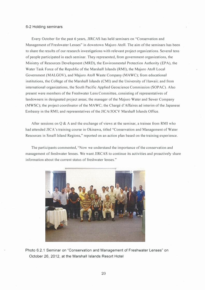
Every October for the past 6 years, JJRCAS has held seminars on "Conservation and
Management of Freshwater Lenses" in downtown Majuro Atoll. The aim of the seminars has been
to share the results of our research investigations with relevant project organizations. Several tens
of people participated in each seminar. They represented, from government organizations, the
Ministry of Resources Development (M RD), the Environmental Protection Authority (EPA), the
Water Task Force of the Republic of the Marshall Islands (RMI), the Majuro Atoll Local
Government (MALGOV), and Majuro Atoll Waste Company (MA WC); from educational
institutions, the College of the Marshall Islands (CMI) and the University of Hawaii; and from
international organizations, the South Pacific Applied Geoscience Commission (SOPAC). Also
present were members of the Freshwater Lens Committee, consisting of representatives of
landowners in designated project areas; the manager of the Majuro Water and Sewer Company
(MWSC); the project coordinator of the MA WC; the Charged' Affaires ad interim of the Japanese
Embassy in the RMI; and representatives of the JICA/JOCV Marshall Islands Office.
After sessions on Q & A and the exchange of views at the seminar, a trainee from RMI who
had attended J ICA 's training course in Okinawa, titled "Conservation and Management of Water
Resources in Small Island Regions," reported on an action plan based on the training experience.
The participants commented, "Now we understand the importance of the conservation and
management of freshwater lenses. We want JIRCAS to continue its activities and proactively share
information about the current status of freshwater lenses."
Photo 6.2.1 Seminar on "Conservation and Management of Freshwater Lenses" on
October 26, 2012, at the Marshall Islands Resort Hotel
20
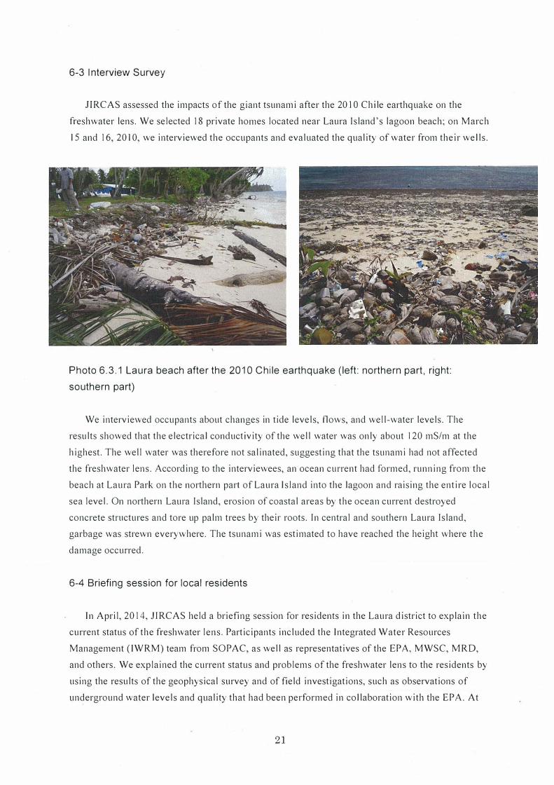
6-3 Interview Survey
J IRCAS assessed the impacts of the giant tsunami after the 20 IO Chi le earthquake on the
freshwater lens. We selected 18 private homes located near Laura Island's lagoon beach; on March
15 and 16, 2010, we interviewed the occupants and evaluated the quality of water from their wells.
Photo 6.3.1 Laura beach after the 201 O Chile earthquake (left: northern part, right:
southern part)
We interviewed occupants about changes in tide levels, flows, and well-water levels. The
results showed that the electrical conductivity of the well water was only about 120 mS/m at the
highest. The well water was therefore not salinated, suggesting that the tsunami had not affected
the freshwater lens. According to the interviewees, an ocean current had formed, running from the
beach at Laura Park on the northern part of Laura Island into the lagoon and raising the entire local
sea level. On northern Laura Island, erosion of coastal areas by the ocean current destroyed
concrete structures and tore up palm trees by their roots. In central and southern Laura Island,
garbage was strewn everywhere. The tsunami was estimated to have reached the height where the
damage occurred.
6-4 Briefing session for local residents
In April, 2014, JIRCAS held a briefing session for residents in the Laura district to explain the
current status of the freshwater lens. Participants included the Integrated Water Resources
Management (IWRM) team from SOP AC, as well as representatives of the EPA, MWSC, MRD,
and others. We explained the current status and problems of the freshwater lens to the residents by
using the results of the geophysical survey and of field investigations, such as observations of
underground water levels and quality that had been performed in collaboration with the EPA. At
21
the end of the session, we felt that we had won the understanding of the residents.
Photo 6.4.1 A briefing session for residents of Laura Island
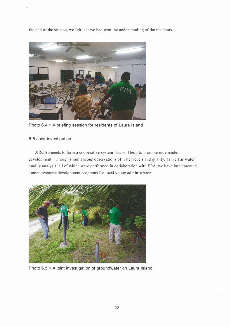
6-5 Joint investigation
JIRCAS needs to form a cooperative system that will help to promote independent
development. Through simultaneous observations of water levels and quality, as well as water
quality analysis, all of which were performed in collaboration with EPA, we have implemented
human resource development programs for local young administrators.
Photo 6.5.1 A joint investigation of groundwater on Laura Island
22
Appendix
Chapter 7 Use of consultant
Necessary measures should be implemented to facilitate activities relating to the maintenance
and recovery of water cycle, which are conducted by technology consultant etc.
7-1 Boring survey
7-1-1 Outline
1) Objective
to install two observation holes to obtain basic information on the movement of the freshwater
lens in Laura, Majuro, Marshall Islands
2) Place
Laura, Majuro Atoll, the Republic of the Marshall Islands
3) Period
June 23 to July 5, 2009
4) Contents
• Boring :<p86mm Site No. 6: Excavation Length= 15 m Site No. I 0: Excavation Length= 16 m
• Pipeline: VP50 with strainer Site No.6: Length= 16 m Site No. I 0: Length= 17 111
• In-situ Permeability Test: Casing method: once in each hole
7-1-2 Methods
l ) Preparation
Boring scaffold, boring machine, and excavation machine tool are transported from Japan by ship
according to the ship schedule. Local site conditions are inspected before the works start.
2) Access and Safety Management
Getting access to the site etc. were conducted after the land owners approve the entering to their
lands at the land owners' meeting. Safety cones and a traffic control personnel were arranged to
make sure the pedestrian safety during the works.
3) Installation and removal of scaffold
Boring scaffold system was temporarily installed by single pipes. The minimum space, which was
necessary for the installation of the boring machine, was occupied and used. After the inspection
of the excavation depth was conducted by JIRCAS, the boring machine etc. were removed and
the working space was recovered as it was.
4) Boring (excavation works)
Oil-feed Boring Machine was used for the excavation. Non-core boring whose diameter of the
excavation was 86 mm was conducted. Not only a casing pipe was inserted but also the thickner
was used for the protection of the wal I of the excavated hole as the collapse of it was extremely
recognized.
23
5) Pipe works
After the excavation of the ground in 86111111 was finished, PVC pipe was installed in the hole.
Then, filtering materials were inserted between the pipe and the excavated soil wall. They are
compacted not only by shaking the pipe but also by adding water when they were inserted. The
height of the pipe from the ground is about 20 cm. The ground around the hole was covered by
mortar. To remove the slime and the mud cake attached inside the pipe, water cleaning was
conducted. After the cleaning was finished, the recovery of the permeability is expected.
6) In-situ Permeability Test
In-situ permeability test was conducted By using the casing through non-steady method at the
observation holes.
7-1-3 Installation of observation holes
I) Materials
PVC pipe, whose opening rate is I 0.8 %, was used for the strainer. The reason why
this pipe was used is that the pipe never uses the poisonous and artificial coloring
materials, which do not include zinc.
Photo 7 .1.1 Joint of PVC pipe (left) and Slit of PVC pipe (right)
Table? .1.1 Pipe Size
Nominal Diameter Outer Diameter Inner Diameter
50 mm 60 111111 51 111111
24
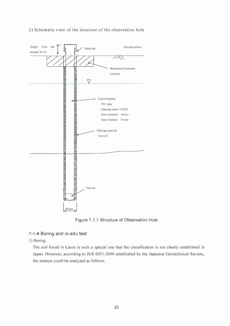
2) Schematic view of the structure of the observation hole
Height from the Head cap
ground: 20 cm
0
Tail cap
Ground surface
Waterproof treatment
(mortar)
Guard Pipeline
PVC pipe
Opening muon I 0.06%
Outer diameter 60mm
Inner diameter 51 mm
Filtering material
(gravel)
Figure 7.1.1 Structure of Observation Hole
7-1-4 Boring and in-situ test
I) Boring
The soil found in Laura is such a special one that the classification is not clearly established 111
Japan. However, according to JGS 0051-2000 established by the Japanese Geotechnical Society,
the stratum could be analyzed as follows.
25
2) Stratum Organization
Table 7.1.2 Stratum Organization
Site No. Thickness Stratum Main Characteristics
(m) Classification
From the ground surface to the depth of I. 7 meters, there are sands whose particles are uniformly-sized.
No.6 11.35 Sand stratum From I. 70 to the depth of I I .3 5 meters, water content ranges from small to medium, soils mainly consist of fine sands with small amount of angular gravels (diameter of about 2 to IO mm). Heavy water leakage and soil collapse
GL: can be observed. Distribution of the gravel stratum can be observed at the
l.83m depth than 11.35 meters. Sand and gravel with large water content whose diameter is about 50 to 60 111111
3.65 Gravel stratum (collapse ground) can be observed. Diameter of main gravel is about 2 to IO mm among which loose sand is 111 ixed with si It. Medi um-compacted as a whole but densely compacted below the depth of 15 meters. Buried soi I mixed with rubble can be observed from the ground surface to the depth of 1.1 Om. Fine sands with small to medium water content can be mainly observed
No.IO 9.7 Sand stratum from the depth of 1.10 111 to 6.60 m, in which wood roots are mixed. Loose and soft silty sands mixed with humic matter (mainly wood block) can be observed from the
GL: depth of 6.60 m to 9. 70 m. Bad and putrid smell can be recoimized
2.17m Th is stratum is distributed below the depth of 9. 7 m. Loose sand and gravel with large water content
6.3 Gravel stratum (collapsed ground) with coarse gravel whose diameter is about 50 to 60 mm. Diameter of main gravel is about 2 to IO mm. among which loose sand are mixed with silt.
3) In-situ Permeability Test
The result of the test shows that in terms of the permeability the soil property is classified into
medium category according to the permeability coefficient of 3.02E-05"-'8.57E-05 (m/s).
Table 7.1.3 Results of the Permeability Test
Number Depth (GL-m) Soil Property Permeability k (mis)
No.6 6.0 to 6.3 Sand with gravel 3.02E-05
No.JO 6.0 to 6.3 Sand with gravel 8.57E-05
26
Appendix
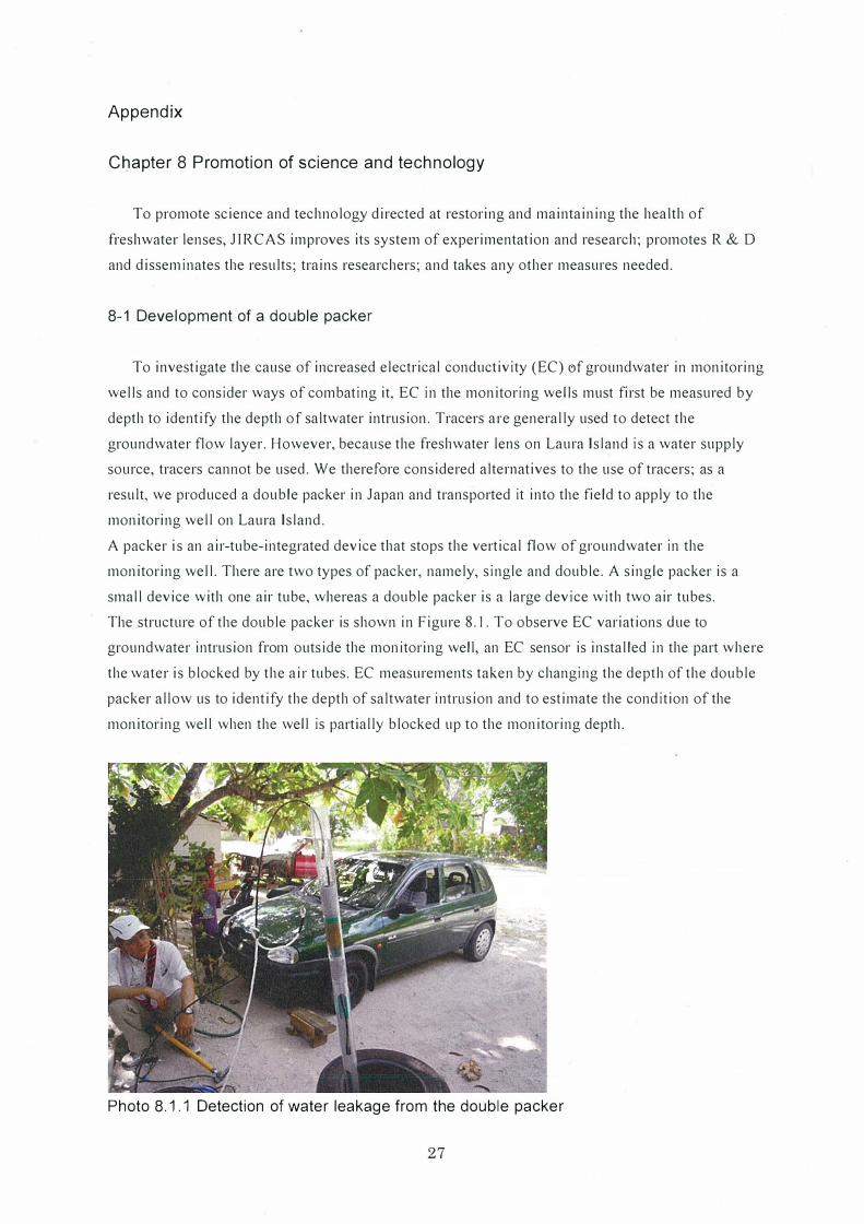
Chapter 8 Promotion of science and technology
To promote science and technology directed at restoring and maintaining the health of
freshwater lenses, JIRCAS improves its system of experimentation and research; promotes R & D
and disseminates the results; trains researchers; and takes any other measures needed.
8-1 Development of a double packer
To investigate the cause of increased electrical conductivity (EC) ef groundwater in monitoring
wells and to consider ways of combating it, EC in the monitoring wells must first be measured by
depth to identify the depth of saltwater intrusion. Tracers are generally used to detect the
groundwater flow layer. However, because the freshwater lens on Laura Island is a water supply
source, tracers cannot be used. We therefore considered alternatives to the use of tracers; as a
result, we produced a double packer in Japan and transported it into the field to apply to the
monitoring well on Laura Island.
A packer is an air-tube-integrated device that stops the vertical flow of groundwater in the
monitoring well. There are two types of packer, namely, single and double. A single packer is a
small device with one air tube, whereas a double packer is a large device with two air tubes.
The structure of the double packer is shown in Figure 8.1. To observe EC variations due to
groundwater intrusion from outside the monitoring well, an EC sensor is installed in the part where
the water is blocked by the air tubes. EC measurements taken by changing the depth of the double
packer al low us to identify the depth of saltwater intrusion and to estimate the condition of the
monitoring well when the well is partially blocked up to the monitoring depth.
Photo 8.1.1 Detection of water leakage from the double packer
27
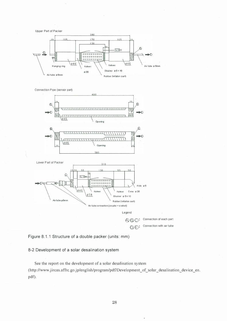
Upper Part of Packer
\CD
Hanging ring
Air lube ¢6mm
Connection Pipe (sensor part)
Lower P a1t of Packer
Air lube ¢ 6mm
Rubber (inflation part)
Hole ¢6
Cone ¢ 38
Strainer ¢ 5X 10
Rubber (inflation pa rt)
Air tube c onnection (coupler+ s ockel)
Legend
Figure 8.1.1 Structure of a double packer (units: mm)
8-2 Development of a solar desalination system
Connection of each part
Connection with air lube
See the report on the development of a solar desalination system
(http://www.jircas.affrc.go.jp/engl ish/program/pdf/Development_ of_ solar_ desalination_ device_ en.
pdf).
28
Appendix
Chapter 9 Ensure international collaboration and promote international cooperation
Restoration and maintenance of the health of freshwater lenses are important issues in atoll
islands. From this perspective, JIRCAS ensures international collaboration in restoring and
maintaining healthy freshwater lenses; promotes technological cooperation on adequate and
efficient use of water; and promotes other types of international cooperation.
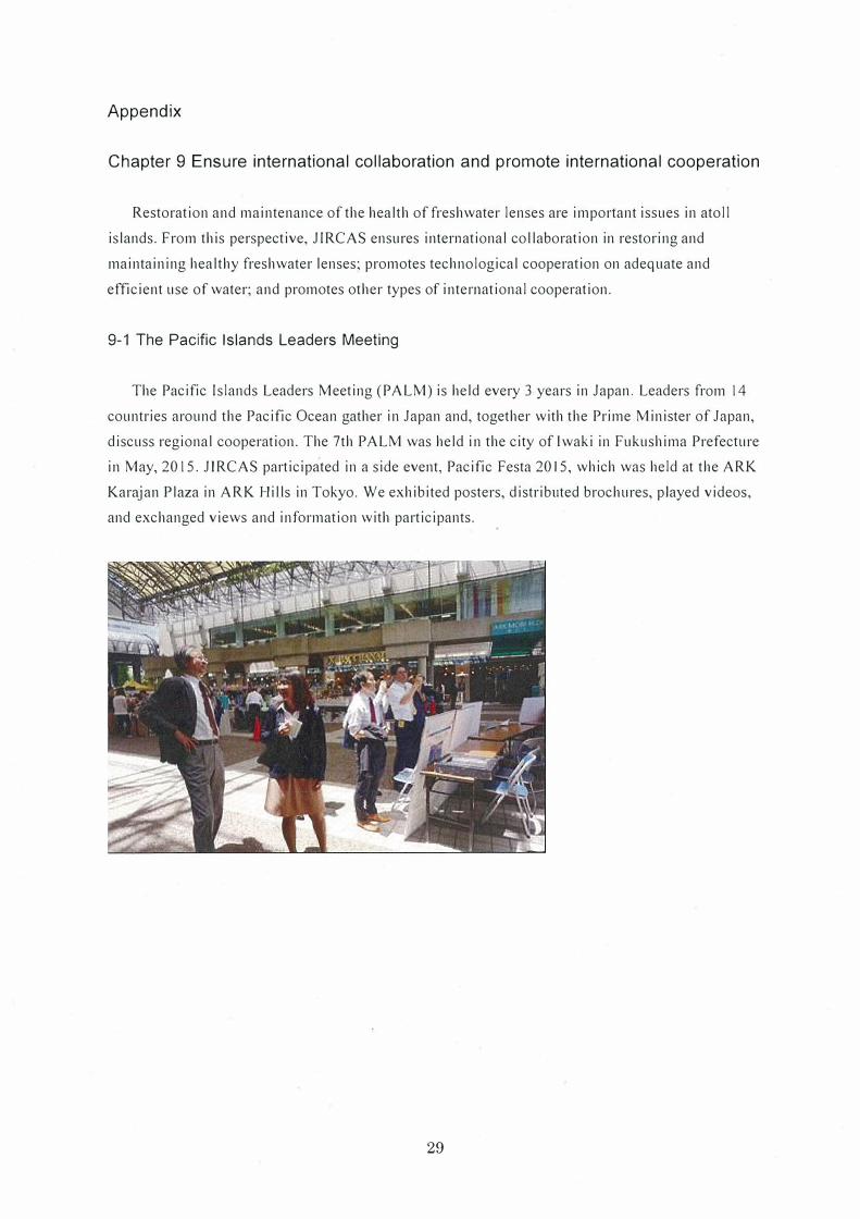
9-1 The Pacific Islands Leaders Meeting
The Pacific Islands Leaders Meeting (PALM) is held every 3 years in Japan. Leaders from 14
countries around the Pacific Ocean gather in Japan and, together with the Prime Minister of Japan,
discuss regional cooperation. The 7th PALM was held in the city of lwaki in Fukushima Prefecture
in May, 2015. JIRCAS participated in a side event, Pacific Festa 2015, which was held at the ARK
Karajan Plaza in ARK Hills in Tokyo. We exhibited posters, distributed brochures, played videos,
and exchanged views and information with participants.
29
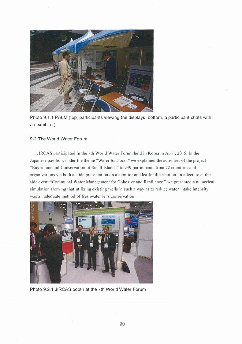
Photo 9.1.1 PALM (top, participants viewing the displays; bottom, a participant chats with
an exhibitor)
9-2 The World Water Forum
JIRCAS participated in the 7th World Water Forum held in Korea in April, 2015. In the
Japanese pavilion, under the theme "Water for Food," we explained the activities of the project
"Environmental Conservation of Small Islands" to 949 participants from 72 countries and
organizations via both a slide presentation on a monitor and leaflet distribution. In a lecture at the
side event "Communal Water Management for Cohesive and Resilience," we presented a numerical
simulation showing that utilizing existing wells in such a way as to reduce water intake intensity
was an adequate method of freshwater lens conservation.
Photo 9.2.1 JIRCAS booth at the 7th World Water Forum
30
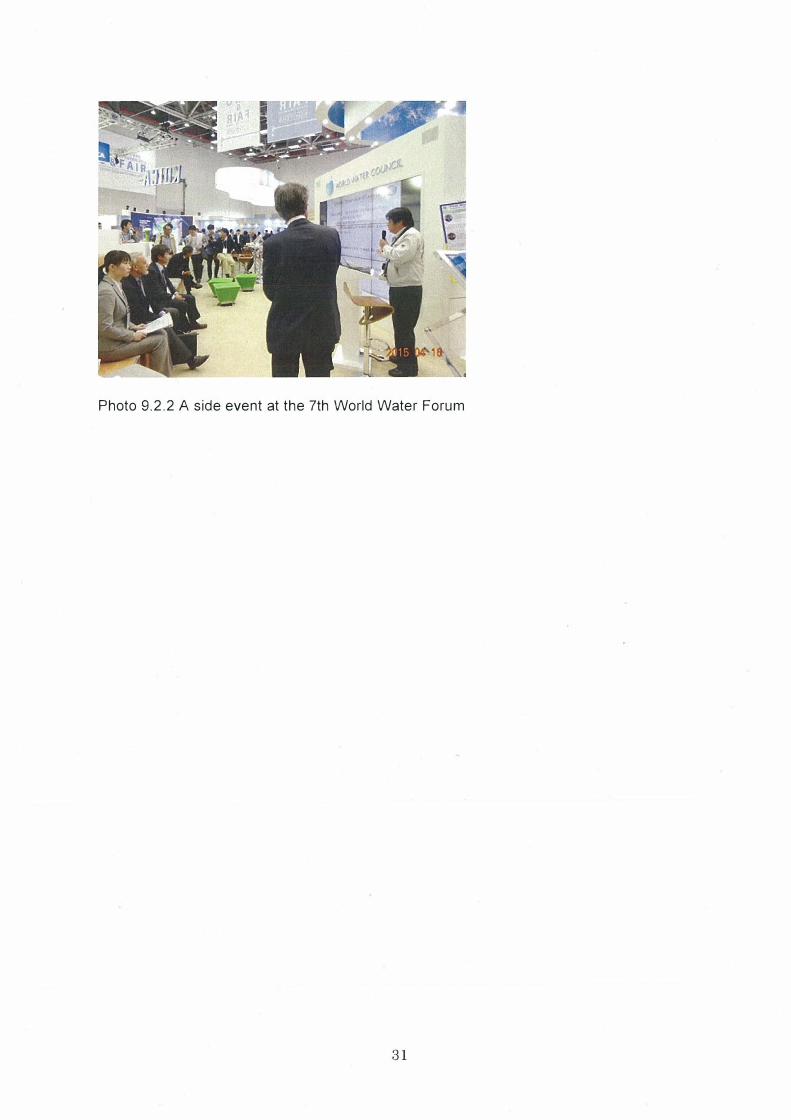
Photo 9.2.2 A side event at the 7th World Water Forum
31
Appendix
Chapter 10 Others
10-1 Papers
· Koda, K., Kobayashi, T., lshida,S., Yoshimoto, S. (2014.11) Numerical Simulation of freshwater
Lens in Laura Island, Geotechnical Engineering Magazine of the Japanese Geotechnical Society, Vo.62,
No.11/12, pp.30-33. (in Japanese)
• Koda, K., Kobayashi, T., Ishida, S., Yoshimoto, S., Kondou, Y., Kawamitsu, Y., and Ueno,
M.,(2013.10) Drought Impact on Freshwater Lens and the Countermeasures for Sustainable Irrigation,
I st Irrigation Forum, pp.63.
• Koda, K., Manpuku, Y., Kobayashi, T., Ishida, S., Yoshimoto, S., and Okubo, M.,(2013.7) A Study
of Sealing Effect in the Observation Well of the Freshwater Lens at Laura Island, Republic of the
Marshall Islands, JARQ, Yo.47, No.3, pp.257-272.
• Koda, K., Kobayashi, T., Ishida, S., Yoshimoto, S. (2013.7) Estimation of Hydraulic Parameters of
Freshwater Lens Aquifer in Laura Island, Water, Land and Environmental Engineering of the Japanese
Society of Irrigation, Drainage and Rural Engineering, Vol.81, No. 7, pp.541-545. (in Japanese)
• Ishida, S., Yoshimoto, S., Kobayashi, T., Koda, K., Nakazato, H. (2013.6) Application of
Geophysical Exploration for Investigation of Freshwater Lens in Small Island, Geotechnical
Engineering Magazine of the Japanese Geotechnical Society, Vo.61, No.6, pp.32-35. (in Japanese)
• Kobayashi, T., Koda, K.(2012.10) Development of Survey Method for Freshwater Lens in Marshall
Islands JIRCAS Working Repo1177
• Ishida, S.,, Yoshimoto, S., Kobayashi, T., Koda, K., Tsuchihara, T., Nakazato, H., Masumoto, T., and
Imaizumi, M. (2011.3) Measurement of freshwater-saltwater interface depths using geophysical
prospectings, Technical Report of the National Research Institute of Agricultural Engineering, No.21 I,
pp.9-20. (in Japanese)
10-2 Exhibition
Exhibition and presentation were conducted at the opportunities of Global Festa Japan (Tokyo),
Public Exhibition in Tsukuba, The 611, World Water Forum, The 6111 Pacific Islands Leaders Meeting, and
the I 51 World Irrigation Forum etc.
10-3 Participants list
This manual was completed in cooperation with the following participants.
[RMI]
Japanese Embassy
Hideyuki Mitsuoka, Kazuhiko Anzai, Akiyoshi Kashima, Hiroshi Watanabe, Masataka Mizutani
JICA Marshall Office
Hideki Tomobe, Jyunji Jshizuka, Hironobu Esaki, Tetsuji Nakasone
32
Ministry of Resources and Development
Thomas Kijiner, Rebecca Lorenij, Jabukja Aikne
Majuro Waste Company
Jorelik Tibon
Environmental Protection Authority
Lowell Alik, Debora Baker Manase, Abraham Hicking, Julius Lucky, Joann Komanta, Douglas, Paul
Paul, Rodorigo, Ayaka Kondou
Ministry of Internal Affairs
Representative
Majuro Atoll Local Government
Isaiah Ali
Majuro Water and Sewer Company
Joseph Batol, Alington Robert, Halston deBrum
College of Marshall Islands
Carl Hacker, Diane Miyazoe-deBrum, Runway Foster, Biuma Samson
Majuro Weather Service
Leee Jacklick
Marshall Islands Journal
Giff Johnson
[Others]
SPC (Fiji)
Peter Sinclair
USGS (Hawaii)
Stephen Gingerich and Marshall team
University of Hawaii
Glen Fukumoto
Schlumberger Co. Ltd. (Canada)
Miln Harvey
GIZ (Germany)
Walter Berier
[Japan]
Pacific Islands Center
Kazuyoshi Ogawa, Takehiro Kurosaki
Institute for Rural Engineering in Japan
Satoshi Ishida, Shuhei Yoshimoto, Katsushi Shirahata, Takeo Tsuchihara
Aoiteck Co.Ltd.
Masaaki Okubo
National Institute for Environmental Studies in Japan
Hiroya Yamano
JIRCAS
Masami Yasunaka, Kunihiro Doi, Nobuyoshi Fujiwara, Tsutomu Kobayashi, Kazuhisa Koda
( corresponding author)
33
Ministry of Resources and Development
Thomas Kijiner, Rebecca Lorenij, Jabukja Aikne
Majuro Waste Company
Jorelik Tibon
Environmental Protection Authority
Lowell Alik, Debora Baker Manase, Abraham Hicking, Julius Lucky, Joann Komanta, Douglas, Paul
Paul, Rodorigo, Ayaka Kondou
Ministry of Internal Affairs
Representative
Majuro Atoll Local Government
Isaiah Ali
Majuro Water and Sewer Company
Joseph Batol, Alington Robert, Halston deBrum, lseia Aiseia
College of Marshall Islands
Carl Hacker, Diane Miyazoe-deBrum, Runway Foster, Biuma Samson
Majuro Weather Service
Leee Jacklick
Marshall Islands Journal
Giff Johnson
[Others]
SPC (Fiji)
Peter Sinclair
USGS (Hawaii)
Stephen Gingerich and Marshall team
University of Hawaii
Glen Fukumoto
Schlumberger Co. Ltd. (Canada)
Miln Harvey
GIZ (Germany)
Walter Berier
[Japan]
Pacific Islands Center
Kazuyoshi Ogawa, Takehiro Kurosaki
Institute for Rural Engineering in Japan
Satoshi Ishida, Shuhei Yoshimoto, Katsushi Shirahata, Takeo Tsuchihara
Aoiteck Co.Ltd.
Masaaki Okubo
National Institute for Environmental Studies in Japan
Hiroya Yamano
JIRCAS
Masami Yasunaka, Kunihiro Doi, Nobuyoshi Fujiwara, Tsutomu Kobayashi, Kazuhisa Koda
( corresponding author)
33
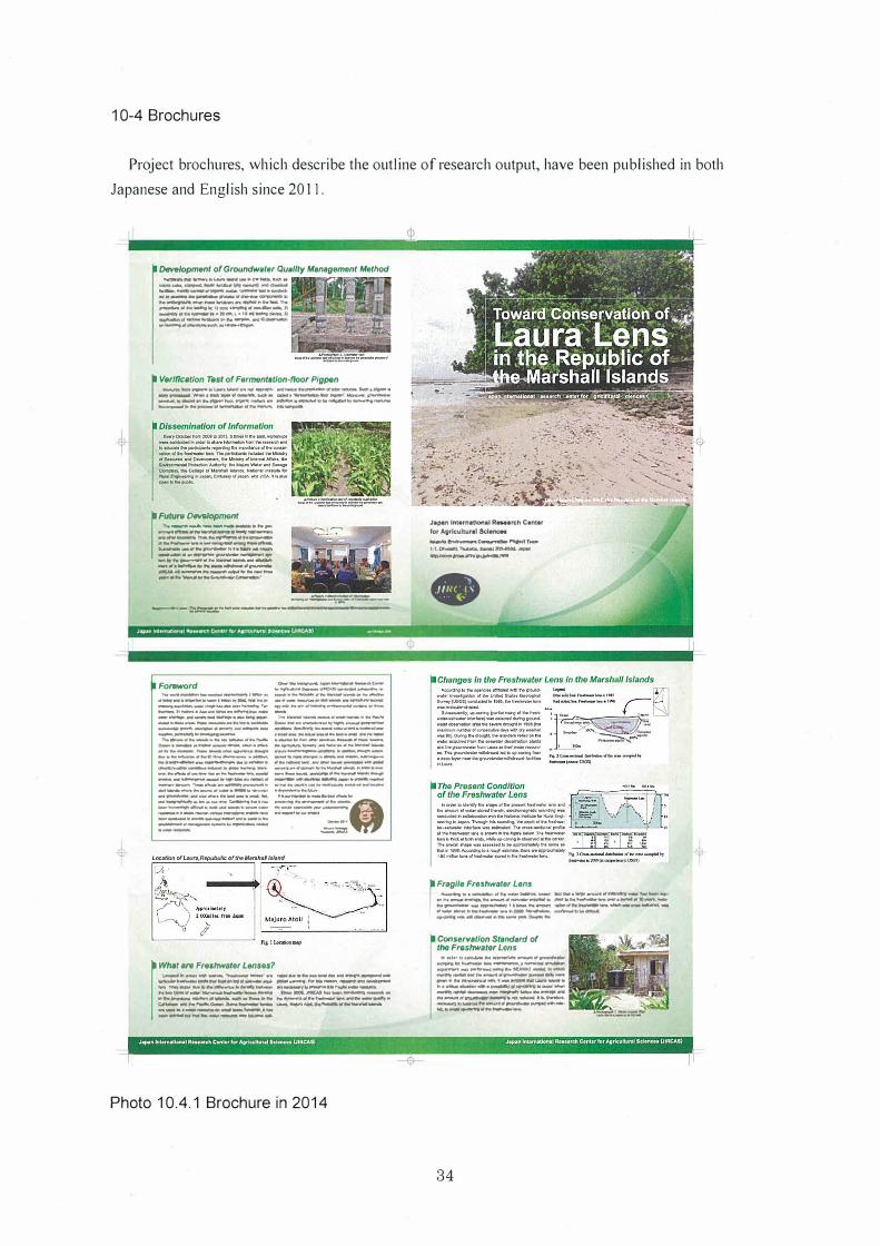
10-4 Brochures
Project brochures, which describe the outline of research output, have been published in both
Japanese and English since 2011.
Development of Groundwoter Q11111/ty M•nagement Method .-.--.. �--- .............
.... ...ii.;......, ...... ,....,,,..,..__.,. - ---...-... ............ ,,, .... -�--· .......................... ...-.. ---..-.. ... _......._ .... ...,_..,..., ......... .,,. ----.. -.-.,1-...... .,_.... ... f) ......_,.,.,...,._. •.• -� . ., ... �-.11
....... -...... ...._ ..... ......,_,.. ................. ., ............. _.,.......
r Verlflutlon Test of Fermont•Uon-noor Plgp,,n ...._ ..... ,,..... .. �...._ ...... ...,.... .... .._ .. ,....._. ___ ............. .... .._.. ..... _IIQ9'., _____ ..... ,.,_......,..........,...,...._._ ................ ..,.._._ ............ ..-............ i.,_.,._............. ___ .,�_ .. _ ... _.,...
rF:::=-�-......
_..,... ........................ ,.. ___ ........ """ ................. _....... _ ... ....._ ................. _,. ... .... .___., ... ,,__ .... IIWI> .. ....... ....... ,, .. _......,___,.......,. -..... ....,._,, ... ...,.,. ................... _,,._.....,.,..,. ___ __.MICAI .. .._.. .. _...,. ..... __ ......... ._ .... ..,_�.
-..:::=.:�·----..___.,_ �.=::::.,.. ___ .. ,.. ____ .. __ _.,. •. _. __
IFo-rrJ ,,.. _____ __..,., __ .,----·--·-·-.,---.. � -------------.""' ...._Ji ______ _...,._..,. --..---�·-..... -_ .. ______ ... ...., .. --_ _...._._.,. ............ _ -::--.. ::·::::.=:i:::--.... -0..,11- ...... ---. -· -
.. .,. .. ______ .....,. ....... _., .... _..__.-....,. ... _...... _______ .. ----....-....... -_ .. ______ ... ___ _ ..-.-�-... --... -· :::..-=. :-..:::, :...-:::.::-::.: -...--... --.. --.. -. ....... �------..-·-_ _........,, _____ .. ___ ... --.--...... ----..---" ... "_"' ..._,,,.__,..._ ... _.__ ·--
_..,. ___ .,.. __ c-..,.,.,.._.._�--.. _ ,, ... ....,_,,, .. ___ ... _ ____ .. ___ ..,_.._ ·---,,,.-....-........ --
l'- ___ ,,, ___ .... _
0-- .. --........ --..-- .....-..iw _______ _ ·--·----... -·- _ ... _·-·----·---.-_,, ____ .,.. __--.....-----..-...-...... ._ .. ___ __,,,.,. _______ ....,,, __.,._,,,_,,, ... __ .. __ _
==--=--=-==-== __ .. _,_ .. _...., __ _. __ .. ,,.._
.. :.:::--=.-:.:=:Q.. ____ ____ -�--.... ·...:.
_ ... -
..::::::=
r WMt are Fre•-.r Lenses? '-"-'"" .. _ ...................... .._.. .... _ ....... _ ..................... ............. ..._ ........... -.....-.................... -.-.... ......-.... .... --·---.....;,.------- ... _,. .. ,...... ......... __ _ ... _____ ..,,,._...._.._ .................................. ._. .... _.._ ........ ., ...... __ ._ ....... .,_ ................ .,,. ..... ...._. .. c:....- .......... .,._, ..... ..,,,,_...._ �� .......... �,, .......... ...... ---·--... -.... ....... ----... ----""--
Photo 10.4.1 Brochure in 2014
¢
Japw, lnt..-nfflOnal R...arch Cent.,
fOf Agricultural Sdenc:89
...... �C:---"'"iKCT-. 1-l,°""""""l'WillM. ...............
----
•
r Fragile Freshw.ier I.ens ........... ...._..,, ... _......., ..... �--�--......... __ _ ...... -_,.. .... _.,,_.......,_ ........ ....._ ... __ ,..... ......... -.......... ----.1• ...... - ......... ....._. ....... __ ..._,.,_ --- .... -- .. %111� ........... -... ..._.._ ............... _,_� .. Conservation StandorrJ of the Frrntrwator Lons ........ """"'"'._ .......... _.,.,_....., ,..... ________ .......
_--,._.,.._ ...... IIM'llll,I' ....... ...... _.., ..... _ ... _,,,.,..__.,.._ ... _......... ___.._ ._......,._r.--_ .." ..... ..._ .... ___,..,.,......_ ....._..,....,....__.........,.. ...... _..,_ ..._...,,�_,. .. ....._. ... .........._....., ............. _,,....,_,....... ... _....._....,..,,,,_.._. ....
34