Late Quaternary Pollen Diagrams from the Canadian Arctic Barren Grounds at Pelly Lake, Northern...
20
The Regents of the University of Colorado, a body corporate, contracting on behalf of the University of Colorado at Boulder for the benefit of INSTAAR Late Quaternary Pollen Diagrams from the Canadian Arctic Barren Grounds at Pelly Lake, Northern Keewatin, N.W.T. Author(s): Harvey Nichols Source: Arctic and Alpine Research, Vol. 2, No. 1 (Winter, 1970), pp. 43-61 Published by: INSTAAR, University of Colorado Stable URL: http://www.jstor.org/stable/1550140 . Accessed: 16/06/2014 05:02 Your use of the JSTOR archive indicates your acceptance of the Terms & Conditions of Use, available at . http://www.jstor.org/page/info/about/policies/terms.jsp . JSTOR is a not-for-profit service that helps scholars, researchers, and students discover, use, and build upon a wide range of content in a trusted digital archive. We use information technology and tools to increase productivity and facilitate new forms of scholarship. For more information about JSTOR, please contact [email protected]. . INSTAAR, University of Colorado and The Regents of the University of Colorado, a body corporate, contracting on behalf of the University of Colorado at Boulder for the benefit of INSTAAR are collaborating with JSTOR to digitize, preserve and extend access to Arctic and Alpine Research. http://www.jstor.org This content downloaded from 195.78.108.163 on Mon, 16 Jun 2014 05:02:47 AM All use subject to JSTOR Terms and Conditions
-
Upload
harvey-nichols -
Category
Documents
-
view
212 -
download
0
Transcript of Late Quaternary Pollen Diagrams from the Canadian Arctic Barren Grounds at Pelly Lake, Northern...

The Regents of the University of Colorado, a body corporate, contracting on behalfof the University of Colorado at Boulder for the benefit of INSTAAR
Late Quaternary Pollen Diagrams from the Canadian Arctic Barren Grounds at Pelly Lake,Northern Keewatin, N.W.T.Author(s): Harvey NicholsSource: Arctic and Alpine Research, Vol. 2, No. 1 (Winter, 1970), pp. 43-61Published by: INSTAAR, University of ColoradoStable URL: http://www.jstor.org/stable/1550140 .
Accessed: 16/06/2014 05:02
Your use of the JSTOR archive indicates your acceptance of the Terms & Conditions of Use, available at .http://www.jstor.org/page/info/about/policies/terms.jsp
.JSTOR is a not-for-profit service that helps scholars, researchers, and students discover, use, and build upon a wide range ofcontent in a trusted digital archive. We use information technology and tools to increase productivity and facilitate new formsof scholarship. For more information about JSTOR, please contact [email protected].
.
INSTAAR, University of Colorado and The Regents of the University of Colorado, a body corporate,contracting on behalf of the University of Colorado at Boulder for the benefit of INSTAAR are collaboratingwith JSTOR to digitize, preserve and extend access to Arctic and Alpine Research.
http://www.jstor.org
This content downloaded from 195.78.108.163 on Mon, 16 Jun 2014 05:02:47 AMAll use subject to JSTOR Terms and Conditions

Arctic and Alpine Research, Vol. 2, No. 1, 1970, pp. 43-61
LATE QUATERNARY POLLEN DIAGRAMS FROM THE CANADIAN ARCTIC BARREN GROUNDS AT PELLY LAKE,
NORTHERN KEEWATIN, N.W.T.
HARVEY NICHOLS
Institute of Arctic and Alpine Research and
Department of Biology University of Colorado
Boulder, Colorado 80302
ABSTRACT
Two peat monoliths were recovered from the high Arctic tundra, now too dry and cold to per- mit peat growth, near Pelly Lake (66?N, 101 ?W). The organic materials began to accumulate at 3,400 and 1,100 BP respectively, and both ceased shortly after 900 BP. Absolute pollen counts, based on numbers of pollen grains per gram (oven-dry weight), revealed parallel changes in representation of Pinus and Picea pollen which were windblown into the tundra from the Boreal conifer forest 400 to 500 km to the south and west. The absolute numbers of pine and spruce pollen declined after 3,360 ? 70 BP to joint minima at about 2,080 + 60 BP, then rose and culminated in joint maxima at 900 ? 75 BP, and then decreased. These variations in Pinus and Picea counts were probably due to the previously established quasi-latitudinal movements of the forest-tundra ecotone described from Ennadai Lake (500 km south), with which they were syn-
chronous and parallel. The local tundra taxa pro- vided little palynological evidence of climatic changes.
The suggested climatic history is that a period of cold summers followed 3,400 BP, with an epi- sode of maximum severity at ca. 2,100 BP, then a period of warmer summers occurred which cul- minated about 900 BP, and a subsequent cold dry phase, which extended to the present, stopped peat growth in this area. The Pinus and Picea maxima coincided with the shortlived growth of a local peat bank from 1,060 ? 55 to 940 + 60 BP which was synchronous with the Scandinavian ex- ploration and colonization of the North Atlantic. The detailed correlation of these pollen diagrams with that from Ennadai Lake further encourages the comparison of the late Quaternary climatic history of northern Canada with that of northwest Europe.
INTRODUCTION
Peat monoliths for pollen analysis and radio- carbon dating were collected from two sites in the neighborhood of Pelly Lake, northern Keewatin, Northwest Territories, Canada (66005'N,
101 04'W and 66008'N, 101?04'W) as part of a continuing investigation into the late Quater- nary history of vegetation and climate in Canada (Nichols, 1967a, b, c; 1969a and b; Figure 1).
H. NICHOLS / 43
III
I I
This content downloaded from 195.78.108.163 on Mon, 16 Jun 2014 05:02:47 AMAll use subject to JSTOR Terms and Conditions

The sites lie in the Barren Grounds which are characterized by an impoverished flora and fauna. The fossil organic materials collected in 1966 from this treeless high Arctic tundra are shallow and represent only fractions of the postglacial his- tory of the area, but they are interesting for their relevance to previous studies (Nichols, 1967b, c; 1969b) which recently made the first tentative
comparisons of the late Quaternary climatic his- tories of parts of central Canada and northern Europe. There are very few published fossil pollen diagrams from the Canadian high Arctic (Teras- mae, 1961), they have yielded little paleoclimatic evidence (Terasmae, 1967), and they have proved difficult to interpret (Hegg, 1963; Bartley, 1967).
TOPOGRAPHY
The area of investigation lies 8 km northeast of an arm of Pelly Lake, where a monotonous plain of pitted outwash sands and gravels is interrupted by 60-m cliffs of a flat-topped outwash delta, of about 50 km2 (Figure 2). The bedrock is impure gneissic-granitic rocks, including some schist, of precambrian age (Craig, 1964) but exposures of solid rock were not seen within the radius of a one-day walk from the sites.
The outwash delta was probably deposited in deep water (possibly marine) in a re-entrant notch in the decaying late-Wisconsin Laurentide Ice Sheet. Craig (1964) noted that the Back River near Pelly and Garry lakes was the site of a glacial lake or an arm of the sea. The delta presumably represents a pause in deglaciation which proceeded from northwest to southeast in this region (ibid.) The steepest sides of the delta face southwest and southeast. Scarps of sands and gravels have
FIGURE 1. Location map.
slumped to form small lakes in the flanks of the delta (Figure 2), but no substantial organic ac- cumulation has apparently occurred in these ponds, so that a date could not be assigned to this move- ment (cf. Franks and Johnson, 1964).
The top of the delta is fairly flat, save for numerous small shallow ponds perhaps caused by melting ice blocks. There are clearly marked beaches cut into the southwest side of the delta which were measured by the author with a hand- held level (Abney type) with an accuracy of prob- ably no more than ? 100 cm. The top of the delta is estimated by Weston Blake, Jr. (pers. comm., 1967) to be ca. 213 m a.s.l., and the surface of Pelly Lake is at 152 m (Prest et al., 1967). The upper beach is estimated by Blake to be at ca. 195 m a.s.l. (loc. cit.). My own level- lings indicate that the upper beach is ca. 27 m be- low the level of the top of the delta (actually below a cairn monument at the east end of the feature) i.e., at ca. 186 m a.s.l., and that the lower beach is 12.8 m below the upper beach, or ca. 174 m a.s.l. The lower beach lies 12 to 15 m above the general level of the fairly flat outwash plain to the north of Pelly Lake. The site of the Pelly Lake peat bank is ca. 0.5 km south of the scarp at about 158 to 161 m a.s.l., and 6 or 9 m above Pelly Lake level. The Drainage Lake peat lies on the flat summit of the delta.
FIGURE 2. Flat-topped outwash delta overlooking low-lying Carex meadows and Pelly Lake on the horizon. Note slumped materials, at foot of slope, and enclosed ponds.
44 / ARCTIC AND ALPINE RESEARCH
This content downloaded from 195.78.108.163 on Mon, 16 Jun 2014 05:02:47 AMAll use subject to JSTOR Terms and Conditions

VEGETATION
Quantitative studies of the plant cover were made by Dr. J. A. Larsen at the same time as I was collecting peat samples (summer 1966), but since this data has not been available in published form, the following brief notes from my own observations are submitted as background com- ments on the taxa which constitute the pollen dia- grams; they do not pretend to describe fully the vegetation of the area.
The two sites lie about 450 km north and 500 km east of continuous Boreal forest whose north- ern limit comprises mainly Picea mariana (black spruce) and Picea glauca (white spruce); sub- stantial stands of Pinus banksiana (jack pine) occur in the northern part of the forest but do not form the treeline. Relict outliers of spruce forest reach the Thelon River 200 km south of Pelly Lake (Larsen, 1965).
A major feature of the lower ground between the outwash delta and Pelly Lake was the extent of Carex spp. cover. These sedges occupied the widespread and very extensive wet meadows, the "low Carex meadows" of Larsen (1965), cover- ing depressions which in many cases were former- ly lakes. The ephemeral small circular ponds on the outwash delta were fringed by Carex spp. which occupied the wet floors of the hollows when the summer depression of the permafrost caused the water level to fall. The floor of Drainage Lake has been exposed by the catastrophic outflow of water over the narrow lip at the edge of the outwash delta and the dry lake bottom has been colonized by Eriophorum angustifolium and E. vaginatum. The shores of the numerous perma- nent lakes were bare of vegetation, probably due to the considerable seasonal vertical fluctuations of lake level (ca. 1 m) and the disturbance of the
universally sandy shorelines by ice action. No floating aquatic plants were seen.
Wet ground near the lake edges sometimes bore Salix arctophila, Eriophorum angustifolium and E. vaginatum, and rarely species of Sphagnum. The bases of the hills were often wet from seepage through the sand and gravel of the outwash and from melting of sheltered snowbanks; these damp localities were characteristically occupied by Betu- la glandulosa, the dwarf arctic birch, which grew no higher than ca. 50 cm. The controlling factors for its growth appeared to be availability of abun- dant moisture and perhaps winter protection under the snowbanks from snow-blasting and desiccation (cf. Larsen, 1965; Figure 3).
Drier level ground was occupied by grasses (Hierochloe sp.) and heaths (Ledum palustre, Vaccinium vitis-idaea, Cassiope tetragona) with Empetrum nigrum. Very large areas of the very dry outwash delta top had a dense wiry lichen mat of Alectoria spp. This mat has been partially destroyed, apparently by wind action tearing at the exposed edges of the Alectoria, particularly on steeply-sloping shoulders of the outwash. Poly- gonal frost cracks provided lower sheltered gut- ters below the bare gravel patches, and these pro- tected areas were occupied by remnant strips of vegetation, Ledum palustre, Vaccinium vitis-idaea, and Alectoria spp. (Figure 4). Where fine sand had been blown away there were large extents of bare lag gravel with very occasional tufts of Hierochloe sp. (Figure 5).
Areas of sand accumulation bore cushions of Silene acaulis and Stellaria sp., while Polytrichum communis appeared to be colonizing bare sand and desiccated dead peat surfaces.
FIGURE 3. Face of out- wash delta marked by fos- sil beach lines which are sites of semipermanent snowbanks and are pre- ferred habitats of Betula glandulosa (July 1966).
H. NICHOLS / 45
This content downloaded from 195.78.108.163 on Mon, 16 Jun 2014 05:02:47 AMAll use subject to JSTOR Terms and Conditions

FIGURE 4. The gravel top of the outwash delta is furrowed by fossil polyg- onal frost cracks; these protected channels are oc- cupied by Ledum palustre, Vaccinium vitis-idaea, and A lectoria spp.
FIGURE 5. Lag gravels on the surface of the outwash delta, with occasional tufts of Hierochloe sp.
CLIMATE
This part of north Keewatin lies at the cold pole of continental North America, the region of mini- mum winter temperatures (Tables 1 and 2).
We kept meteorological records at the camp north of Pelly Lake in June-July, 1966 (Ahms- brak, 1968). This period embraced the greater part of the growing season, and yet no rain was measured in this time. Total annual precipitation is estimated to be less than 20 cm (probably only ca. 10 cm) almost all of which is snow. The
solid precipitation is very dry and powdery due to the low temperatures, and I think that little of it accumulates on high exposed ground such as the bare gravel top of the outwash delta, but is gathered by the wind into the lake hollows and valleys, and is blown down from the delta onto the outwash plain. The barrenness of the lag gravels, bare sand, and thin Alectoria lichen mats therefore tends to maintain itself.
The level of permafrost which underlies this
46 / ARCTIC AND ALPINE RESEARCH
This content downloaded from 195.78.108.163 on Mon, 16 Jun 2014 05:02:47 AMAll use subject to JSTOR Terms and Conditions

TABLE 1
Climatological Table for Baker Lake, Keewatin, N.W.T.a
(64018'N, 96?05'W; Alt. 9 m MSL)
Daily Relative Precipitation mean humidity (all forms
Month (?C) (%) mm)
Jan. -34.4 70 2.54 Feb. -35.6 78 5.08 Mar. -26.1 83 7.62 Apr. -18.3 87 5.08 May - 7.2 87 2.54 June 1.1 84 7.62 July 8.9 82 71.78 Aug. 9.4 75 12.70 Sept. 3.3 84 12.70 Oct. - 6.7 87 10.16 Nov. -18.9 92 7.62 Dec. -26.7 82 5.08
Mean -12.8 87 96.52
aBaker Lake is 300 km southeast of Pelly Lake. Based on 4 years of observations prior to 1955 (Kendrew and Currie, 1955).
entire area falls rapidly in the quick-draining sands and gravels of the delta summit, and was beyond the reach of a 1 m probe by early July. Perma- frost remained nearer the surface in the finer, more humic soils of the outwash plain, which has led to waterlogging in the numerous shallow hol- lows.
TABLE 2
Climatological Data from Pelly Lake, 1966
Time Surface temp. Air temp. (C.D.T.) (?C) (?C)
June 24 0000 5.7 4.2 0600 4.2 2.9 0900 4.4 4.4 1200 5.2 6.2 1500 5.8 8.0 1800 5.9 6.6 2100 5.3 5.0
June 28 0000 7.3 9.1 0600 7.6 10.6 0900 10.4 16.0 1200 15.2 19.2 1500 18.2 21.4 1800 14.2 18.3 2100 11.3 12.3
July 2 0000 8.7 9.8 0900 10.8 18.1 1200 15.6 20.4 1500 17.2 22.9 1800 15.8 23.3 2100 13.2 19.7
Selections from data collected June 24-July 7, 1966. Surface temperatures were read on mercury in a glass thermometer inserted ca. 2 cm deep in a 3-5 cm thick lichen mat (Alectoria spp.). Air temperatures were obtained by a hand-held sling psychrometer. Source: Observations by Mr. W. F. Ahrnsbrak, Mr. H. Cole, Dr. J. A. Larsen and the author, and writ- ten communication from Mr. W. F. Ahrnsbrak, 1969 (cf. Ahrnsbrak, 1968).
NONPALYNOLOGICAL EVIDENCE OF ENVIRONMENTAL HISTORY
There is abundant paleoenvironmental evidence from the hinterland of the north shore of Pelly Lake of former conditions somewhat different from the present day. Many of the smaller lakes are surrounded by one or more fossil shorelines reflecting drainage impedance by late-Wisconsin ice, less mature drainage than at present, or per- haps higher lake levels due to an increased pre- cipitation-evaporation budget. An unnamed lake (Monolith Lake, unofficially named by Nichols) has beaches at ca. 4.6 m and 7.3 m above its July 1966 level. However, the modern water level varies as much as 1 m from the meltwater period of early summer (June) to the time when most of the snow had disappeared (August), so the
datum of the July lake level was not permanent. A beach notch ca. 1 m above the July 1966 lake level may be fossil, but alternatively may merely reflect recent high water levels due to runoff of meltwater at Monolith Lake.
The beach notches cut into the unconsolidated outwash material of the delta are the sites of long- lasting snowbanks, some of which, from observa- tions made in 1966, may last throughout the sum- mer (Figure 3).
At present, shoreline beach ridges are being built up, apparently primarily by ice action. In July 1966 floating ice blown by the wind was pushing the beach sand at Monolith Lake into small ridges parallel to the shoreline, and later, as
H. NICHOLS / 47
This content downloaded from 195.78.108.163 on Mon, 16 Jun 2014 05:02:47 AMAll use subject to JSTOR Terms and Conditions

the summer meltwater dispersed, and the lake level fell, these ridges were left preserved above the level of wave action. It is probable that such "push ridges" (Bird, 1967) are also formed dur- ing the winter and spring due to ice expansion. At Monolith Lake the slope of the shore at the south end of the lake is sufficiently gradual that one of these beach ridges (attaining only I m above cur- rent lake level, at a distance of 9 m from the shore) has impeded the surface drainage of the beach and formed a shallow pool occupied by Carex spp., Eriophorum spp., and Sphagnum spp. (Figure 6). A relict example of such a pool was seen behind the 4.5 m raised shoreline, presently about 200 m from the lake at the south shore. This same shallow beach slope exhibits a series of small ridges (ca. 100 cm high) parallel to the modern shoreline which were presumably formed by the above process of ice pushing at times of higher lake level. These fossil shorelines now con- tain frost cracks running parallel to the modem shoreline, and it seems that ice wedging has ac- centuated the form of the fossil beach ridges (Figure 6). Further fossil frost cracks were seen on top of the outwash delta, where they formed low channels, marked by protected strips of vege- tation, below the level of the surrounding lag gravel (Figure 5).
An examination of the air photographs of this region reveals that the numerous wet hollows char- acterizing the pitted outwash plain have traces of shorelines around them and appear formerly to have been lakes. The impression is that the present lake-studded landscape contains only the deeper representatives of former swarms of small lake basins which have now largely dried up.
There are in this area numerous traces of old vegetative surfaces. On the summit of the delta residual mounds project 1 to 1.5 m above the present sandy surface, illustrating the loss of at least 150 cm of sand by wind transport. Other relics of former plant covers are found as buried turf horizons below 1 m or more of blown sand toward the base of the delta (Figure 7). It seems clear that fine minerogenic material from the sum- mit was blown down there when the upper vegeta- tive mat was destroyed (Figure 8).
Further evidence for desiccation and wind ac- tion is found in the large areas of lag gravels which resemble those reported from other deserts (Fig- ure 5). The fine constituents have been blown away, to leave a concentration of pebbles on the surface, which is completely bare of vegetation save for a few lichens on the stones. On some parts of the summit of the delta there are patches of lag gravel interrupted by rectangular lines of lichens occupying depressions formed by fossil ice wedges (Figure 4).
Thus, it is clear that a considerable proportion of the summit area has experienced destruction of its plant cover and deflation of the underlying sand by wind, while the lower area of the outwash plain remains almost completely vegetated, and has accumulated some of the fine materials blown from the delta. The contrast is presumably due to the greater elevation of the delta and its exposure to wind, plus the fact that this deltaic accumula- tion of sand, gravel and pebbles is very well drained, so that climatic changes have had a very marked effect on the plant communities of this outstanding topographic feature. It may be noted that the Pelly Lake peat contained fine sand
FIGURE 6. Monolith Lake circumscribed by fossil beach lines and frost cracks.
48 / ARCTIC AND ALPINE RESEARCH
This content downloaded from 195.78.108.163 on Mon, 16 Jun 2014 05:02:47 AMAll use subject to JSTOR Terms and Conditions

throughout its depth, presumably blown from the summit of the delta which overlooks it.
In summary, these phenomena (deflation of sand, lag gravels, dune construction, and reduced pond and lake levels) point to a past episode of
ORIGIN OF THE 01
The peat beds at Pelly Lake and Drainage Lake and the organic material at MacAlpine Lake (Terasmae, 1967), ca. 100 km northwest of Pelly Lake, began to accumulate at 3,360 ? 70 BP (WIS-216), 1,060 ? 55 BP (WIS-263) (Bender et al., 1968a, b), and 2,330 ? 150 BP (GSC-
relatively dry climate which in this location would normally also imply colder conditions (a supposi- tion which is supported by the evidence for fossil frost cracks associated with the lag gravels).
FIGURE 7. Fossil vege- -\
.
tative surfaces buried by ? blown sand alongside
Monolith Lake.
Y? 'i- :i '
..i . . . .. ..
FIGURE 8. Lag gravels of outwash delta overlooking blown sand accumulation on lower ground (bottom
' left).
ZGANIC DEPOSITS
300) respectively. These three dates coincide with times of climatic change registered elsewhere in Canada (Terasmae, 1961; Nichols, 1967c) and these coincidences suggest that shifts in climate may have promoted such organic accumulation (Nichols, 1969a). There is no modem peat
H. NICHOLS / 49
This content downloaded from 195.78.108.163 on Mon, 16 Jun 2014 05:02:47 AMAll use subject to JSTOR Terms and Conditions

growth at Pelly Lake, due no doubt to the very low precipitation (probably ca. 10 cm per year) and the permeability of the deep sands and gravels which everywhere mantle the bedrock.
It is suggested very tentatively that peat growth may have originated in northern Keewatin during, and as a result of, either a climatic amelioration to warmer summers or a deterioration to colder, drier summers, depending perhaps on local site factors. A climatic warming might have increased summer precipitation available for plant growth by the more frequent occurrence of moist air masses and more convective rainfall within the Pelly Lake area. The magnitude of this effect cannot yet be estimated, and it may have been in- significant even during the warmest period of the postglacial in this area. The increased melting of permafrost or semipermanent snowbanks during an amelioration might have contributed signifi- cantly to the accumulation of organic matter. It has been observed that water is widespread throughout the arctic deserts but is generally not available for plant use because it is frozen. Either or both of these effects might explain the growth of peat at Drainage Lake at 1,060 + 55 BP at a time when a northward extension of the Boreal forest limit occurred in southern Keewatin at 1,160 ? 90 BP or 1,050 ? 180 BP (WIS-17) (Bryson et al., 1965). This is thought to have recorded a rise of mean summer temperatures of about 1.5?C in southern Keewatin (Nichols,
1967c). The maxima of exotic Pinus and Picea pollen in the Pelly Lake diagram at 900 + 75 BP (WIS-245) (Bender et al., 1968a) probably re- sulted from this northward movement of the for- est and the increased incidence of southerly and/ or westerly winds which reached Pelly Lake from the Boreal forest.
The alternative situation, a climatic deteriora- tion to a colder summer climate, is likely to have decreased the moisture brought by relatively warm Pacific or modified sub-tropical air masses, and therefore to have reduced summer precipitation. But reduced summer temperatures might lead to higher levels of permafrost in the soil, encouraging waterlogging at the surface and the existence of shallow ephemeral lakes during the short summer. In 1966 the outwash gravel and sands on the north side of Pelly Lake bore shallow ponds (ca. 1 m deep) during the early summer (June) when the permeable soil was frozen just below the sur- face, but later in July, when the permafrost level in the sand had sunk below the reach of the 1 m probe, the water level fell and the ponds finally dried out as the impermeable frozen layer retreat- ed deeper into the sand. Perhaps this phenomenon explains the origin of organic accumulations at Pelly and MacAlpine lakes at the colder periods around 3,400 and 2,400 BP; i.e., that paludifica- tion occurred as summer meltwater built up over unusually high permafrost levels in previously well-drained soils.
SAMPLING TECHNIQUES
The peat samples from both sites were taken from cleaned exposure faces in the form of mono- liths of continuous blocks about 20 cm cube. The blocks were wrapped in aluminum foil to preserve their structure and moisture, and were kept frozen in the laboratory until sampled. The monoliths were cut into horizontal slices 2 cm thick for stratigraphic and macro-fossil examination and for submission for radiocarbon assay.
Absolute pollen counts based on numbers of
pollen grains per gram (oven dry weight) have been employed in this investigation in addition to the conventional relative pollen percentages. The low pollen productivity of tundra taxa, the long distance transport of relatively large quantities of pollen from the prolific conifers of the Boreal forest, and the likelihood of local pollen over- representation by plants growing close to the sampling site have made this measure even more necessary than usual.
CONTEMPORARY SURFACE POLLEN COUNTS
A graduate student member of the party at Pelly Lake, Mr. H. Cole, collected surface pollen samples from living vegetation mats, moss polsters, etc. at a variety of sites, and he has kindly al- lowed me to quote his unpublished analyses of these materials. In collecting, emphasis was laid
on obtaining living plant material wherever possi- ble because of the danger of sampling the surface of fossil organic matter (such as peat) which in the Arctic may have a present-day surface which is centuries old.
These data (Table 3) illustrate the great local
50 / ARCTIC AND ALPINE RESEARCH
This content downloaded from 195.78.108.163 on Mon, 16 Jun 2014 05:02:47 AMAll use subject to JSTOR Terms and Conditions

variation of pollen percentages within a small area suits emphasize the importance of using absolute as a result of site factors and local overrepresenta- pollen counts for such areas, and the difficulty of tion, an effect noted by Bartley (1967). The re- interpreting local secular pollen variations.
TABLE 3
Percentages of total pollen and spores at neighboring sites at Pelly Lakea
Wet low Carex meadow Xeric Rockfield Carex meadow at base of Ericaceae Alectoria community
on outwash delta outwash delta community on outwash delta a b a b c a b a b
Alnus 3.7 9.3 6.4 2.5 10.9 6.5 8.3 17.3 12.7 Ambrosia 0.2 0..9 Artemisia 0.6 0.5 1.8 Betula 10.9 11.0 28.1 4.2 29.5 7.1 6.8 16.4 15.7 Caryophyllaceae 0.2 0.5 0.5 Compositae 0.4 1.0 Cyperaceae 56.0 29.3 15.2 15.1 24.0 7.8 6.8 9.5 12.7 Ericaceae (plus
Empetrum) 3.3 21.9 29.3 11.2 8.7 57.8 46.2 3.6 21.6 Gramineae 1.5 1.2 9.1 1.1 1.6 5.2 7.6 30.4 15.2 Lycopodium 0.2 0.4 0.5 Picea 1.9 2.0 0.6 1.1 0.6 3.8 1.4 1.0 Pinus 11.5 14.2 12.3 5.3 15.8 13.0 18.1 15.0 17.6 (Pinus/Picea undifferentiated) 1.6 0.6 0.7 0.5 0.6 1.5
Rosaceae 0.6 0.5 Salix 8.9 8.1 1.8 59.7 4.4 0.8 1.8 1.5 Sphagnum 1.5 0.8 0.6 1.5 1.3 1.8
Total counted 459 246 171 285 183 154 132 220 204
aAnalyzed by Mr. H. Cole, 1967
PELLY LAKE
STRATIGRAPHY The following is a simplified account of the
laboratory description of the monolith from the Pelly Lake peat bank:
Surface peat, dark brown and oxidized, almost bare of vegetation save for scattered Polytrichum sp.
0 - 4 cm Dark brown humified rootlet peat with cf. Ericaceae roots
4 - 10 cm Humified rootlet peat with Cy- peraceae remains, sand grains at 8 to 10 cm
10 - 22 cm Fibrous sedge peat; a few sand grains at 16 to 18 cm
22 - 36 cm Coarse grains, base
detritus mud, with sand becoming very sandy at
36 cm+ Sand
PALYNOLOGY There is a considerable amount of consistent
variation in the pollen percentages of the Pelly Lake peat (Figure 9), which is perhaps surprising in so shallow a profile, but the radiocarbon dates establish that the 35 cm of organic material span at least 2,400 radiocarbon years. The peat bed began to accumulate 3,360 ? 70 years BP (WIS- 216) (Bender et al., 1968a) as a coarse sandy detritus mud overlying sand at 35 cm below the modern peat surface. The mud appeared to be
H. NICHOLS / 51
This content downloaded from 195.78.108.163 on Mon, 16 Jun 2014 05:02:47 AMAll use subject to JSTOR Terms and Conditions

conformable with the sand, and throughout this deposit there was no distinguishable break in deposition, though one might have been expected from the shallowness of the organic accumulation, and the absence of a visible hiatus does not ex- clude this possibility. The period of slowest ac- cumulation from 3,400 to 2,100 BP (35 to 26 cm) was represented by lacustrine detritus mud, and since the sediment apparently remained sub- merged throughout this time it is likely that there was indeed very slow organic accumulation with- out omission of any noticeable section of the rec- ord.
After having made observations of the disturb- ance of lake sediments by ice flotation in this re- gion (Nichols, 1967d) and recommendations that such disturbed stratigraphy should not be relied upon (Nichols, 1967e), I was prepared to be very skeptical of the value of the lacustrine section of the stratigraphy, but could see no trace of disturb- ance by this mechanism. This does not mean that this possibility can be entirely ruled out, for mix- ing of homogeneous lake sediments might not be visible in the profile. The pollen representation varied in a way that was consistent with the pollen content of the upper terrestrial peat, and could be most meaningfully interpreted as being compatible with climatic and vegetational events elsewhere in Canada (Nichols, 1967c). I think that the ma- terial may have accumulated in very shallow water which melted rapidly and was not subject to the "bottom ice effect" of Nichols (1967d).
PICEA AND PINUS
The main interest of this pollen diagram (Fig- ure 9) is the behavior of Pinus and Picea. These genera have moderate pollen percentages at the base of the diagram at 35 cm (3,360 ? 70 BP, WIS-216; Bender et al., 1968a) from which they decline to a minimum at 27.5 cm at 2,080 + 60 BP (WIS-292) (ibid.). Pine and spruce increase to their joint maxima at 10 cm at 900 + 75 BP (WIS-245) (ibid.). The values of Pinus and Picea then fall toward the top of the diagram. The top of the peat is now a dry dead surface, almost devoid of living vegetation, and has clearly not been growing recently.
It must be stressed that the changes in the rela- tive pollen percentages in the Pelly Lake diagram are borne out by the changes in the absolute pollen counts, so that the maxima and minima of exotic pollen described above are demonstrably not the result of changes in local pollen production.
The pollen of Pinus and Picea throughout this diagram are thought to be entirely exotic. These genera do not grow in the area today, the nearest representatives being relict stands 200 km to the
south which reproduce vegetatively, with continu- ous open forest being 450 km south and 500 km west. There are no macrofossils of wood, seeds, or leaves, to show that pine or spruce ever grew at Pelly Lake during the period covered by the pollen diagram. Numerous soil stratigraphic pits were dug throughout the area by Mr. H. Cole and my- self, and the many streamside exposures were also examined for such gymnosperm relics, but none was observed.
In a canoe journey made through the tundra of southern Keewatin by Irving and Larsen (Bryson, Irving, and Larsen, 1965) fossil-burned forest horizons containing Picea and Larix wood were found to extend almost continuously as far north as Dubawnt Lake (up to 63?N) 300 km south of Pelly Lake. These materials, dated 3,430 ? 110 BP (WIS-12), 3,550 + 120 BP (WIS-18), 3,650 ? 100 BP (WIS-80), and 3,540 ? 110 (WIS-52) (Bender et al., 1965, 1966), became patchy and died out just north of Dubawnt Lake, but the lack of exploration in central Keewatin makes it uncertain where the northernmost post- glacial limit of fossil forest lies, though it was probably nearer to Dubawnt Lake than to Pelly Lake. The pollen taxa which comprise the rest of the Pelly Lake diagram also suggest that the area was tundra throughout the last 3,000 radiocarbon years.
The representation of Pinus and Picea in this diagram is approximately parallel, with pine hav- ing consistently higher values than spruce. These two pollen types probably came from the Boreal forest more than 400 km to the south (or 500 km west). The ability of Pinus pollen (and to a les- ser extent Picea) to travel long distances by wind is well known (Faegri and Iversen, 1964). Aario (1940) showed by analysis of surface samples in Finland that the percentages of pine and spruce pollen relative to other arboreal pollen fell imme- diately north of the pine-spruce forest (in the birch zone), but that farther out in the tundra their relative importance in the tree pollen diagram in- creased.
These facts lead one to suggest that the persis- tent trends of the Pinus and Picea pollen curves represent variations in the presence during sum- mer of air from the south and/or west which would bring northern Boreal forest pollen to Pelly Lake, probably as a reflection of quasi-latitudinal changes in the location of the forest-tundra margin and the associated Arctic Front. Using this hypo- thesis, it would appear that after 3,400 BP there was a retreat of the northern edge of the Boreal forest southward, and a decline in the frequency of southerly and/or westerly air which reached Pelly Lake during the growing season. This trend
52 / ARCTIC AND ALPINE RESEARCH
This content downloaded from 195.78.108.163 on Mon, 16 Jun 2014 05:02:47 AMAll use subject to JSTOR Terms and Conditions

900 75 B.R
2080 60 B.P
3360 70B.R I
Depth cm.
I I I I -
I I I -
!1111 _ I I I0-
- 15-
- I
- 20-
- I
25 -
35 -
PELLY LAKE, KEEWATIN, Relative Pollen Percentages (solid columns)
20% 20% 40% 20% I 400 5,000 10,000 4,000 5,
4P00 5,000 I
0 r
00 1
40 .I,
0i O0 5,000 I0,000 4,000 5,000
1967
20% 40%/ I . I . 9 .
'''5000 ' '
',000 5,000 I0,000
2 AP+NAP= 300, excluding Cyperaceae, Ericaceae, and Sphagnum
60q% 0 20 40 60 80 10 %
i I_ , i :i i
?Ojo
I I
3,000
Absolute Pollen Numbers per gm. (dashed lines)
< ALNUS BETULA
%
W Sedge Peat
' PICEA PINUS
' 6-
Coarse Sandy Detritus Mud :. Sa n
%, .y;$d4 0%q0 1 CYPERACEAE
\1 s,, A ,, + , 404% IPv-Vls- ^
ANAL.- H. N I CHOLS, 1967
FIGURE 9. Pollen diagram from site north of Pelly Lake, showing relative pollen percentages (solid columns) and absolute pollen numbers per gm oven-dry weight (dashed lines).
I I Fibrous Grass- 1 Sedge Peat
-v p x po ., IOP
IV, C` 9O` C Q ;OV~ C, 't I ~oP Iv;o !? , <
kI
I I I
I
I
This content downloaded from 195.78.108.163 on Mon, 16 Jun 2014 05:02:47 AMAll use subject to JSTOR Terms and Conditions

registered its maximum effect (reflected in the ca. 900 BP, lowest values of Pinus and Picea pollen) at ca. ing a southu 2,080 - 60 BP (WIS-292) (Bender et al., The sequ< 1969a) when presumably the Boreal forest-tundra is apparentl ecotone had retreated to its most southerly position scribed fro] for this period. The basal detritus lake mud ac- (61 10'N, cumulated very slowly (mean rate ca. 1 cm/180 on the basis years between 35 and 27.5 cm) so that the de- and macro- terioration marked by low Pinus and Picea values carbon dat, at 30 cm may have occurred (by extrapolation) 1967a, b, c; ca. 2,600 to 2,500 years BP. The southerly/west- was suggeste erly wind component increased (as the forest limit tion after 3, moved north) from 2,100 BP to a maximum at ward retrea
YEARS BEFORE PRESENT sooo 7000 60OO 5000 4000 3000
, after which it again declined, reflect- vard movement of the forest limit. ence of climatic events suggested above y synchronous with that already de- m Ennadai Lake and Lynn Lake 100055'W and 56050'N, 101003'W) s of soil and peat stratigraphy, pollen fossil analyses, and numerous radio- es (Bryson et al., 1965; Nichols, ;Figures 10 and 11). In that work it
ed that there was a climatic deteriora- 600 to 3,400 BP, marked by a south- t of the forest limit, with a particular-
PPWENT MY 2000 1000 0
I I I I I I I
--Dubawt Lake (63 N) P-L
400
600
-Dimma Lake
-N. end Ennadai Lak (61?N)
--S. end Ennadai Lake
-f rfC
f-t t C-f r
f........Evidence of Forest Growth
t ........ Evid e ' Tundra Vegetation
.......... Estimated Northern Limit Forest
-f
Late isconsin
End _,,Mrair-_
FIGURE 10. A tentative reconstruction of the location of the northern limit of continuous forest along the meridian 100?W. In central Canada. Stratigraphic evidence for forest (f) or tundra (t) is shown by short horizontal lines which represent the radiocarbon date and the standard deviation. The rest of the diagram is based on the pollen diagrams from the north end of Ennadai Lake and from Lynn Lake, and this palynological and stratigraphic evidence is less unequivocal. For instance, the vegetation changes following 5,000 BP are derived from radiocarbon-dated palynological evi- dence, but there is no clear stratigraphic evidence of a change from forest to tundra, so that the magnitude of the ecotonal movements can only be inferred. It is not known how far south of Ennadai the forest retreated between 2,500 and 1,500 BP and after 600 BP. (Figures 10 and 11 from: H. Nichols, The Post-glacial History of Vegetation and Climate at Ennadai Lake, Keewatin, and Lynn Lake, Manitoba (Canada). Eiszeitalter und Gegenwart, 18: 176-197, Ohringen, 1967.)
54 / ARCTIC AND ALPINE RESEARCH
30 r_ MODERN f-
- .si :: NORTJER?N
UMIT ) OF FOREST
500
400 I
Lu
ZOO
200 zoo.
0
-Lyrm lake
This content downloaded from 195.78.108.163 on Mon, 16 Jun 2014 05:02:47 AMAll use subject to JSTOR Terms and Conditions

ly severe episode after 2,600 to 2,400 BP. A warm period prior to and including ca. 1,000 to 900 BP (reflected in a northward advance of the forest) was followed by a cold episode which was severe after ca. 700 BP (and resulted in another forest retreat southward and the cessation of peat growth at Ennadai).
The movements of the forest limit north and south of Ennadai Lake were explained as re- sponses to prolonged changes in the mean summer position of the Arctic Front, which implies an in- creased summer flow of southerly and/or westerly air of tropical or Pacific origin into the Canadian Arctic during warm periods, and a diminution of this effect with increased dominance of arctic air and more north winds in the growing season dur- ing colder periods. This tentative explanation of the earlier data is consistent with the evidence from Pelly Lake, and it is put forward here as the most likely cause of the variation of the percent- ages of Pinus and Picea pollen at this site.
The Keewatin climatic sequence (Nichols, 1967c) has been applied to the palynological his-
tory of Sugluk, in arctic Quebec by Bartley and Matthews (1969); the similarity to Fredskild's (1967) data from west Greenland has been noted previously (Nichols, 1967c). Fredskild's (1969) results from Peary Land, northwest Greenland, indicate that the postglacial thermal maximum in that area fell within the period 4,000 to 3,300 BP, during which time exotic driftwood floated across a partially melted Arctic Ocean to be in- corporated in seaside Eskimo hearths. The centur- ies following 3,300 BP were colder and drier, and this deterioration reached the equivalent of its present-day severity ca. 2,100 BP. Fredskild noted that 8(18o) paleoclimatic data from an ice-cap core from north Greenland supported his conclu- sions (Dansgaard et al., 1969). The climatic vari- ations derived from the 8(18o) data are remark- ably synchronous with the Pelly Lake climatic changes, and closely parallel the spruce and pine curves in the Pelly diagram. The isotopic data points show a progressive temperature decrease from ca. 3,400 BP to minimum values at ca. 2,400 to 2,100 BP, after which there is a sharp
YEARS BEFORE PRESENT PRESENT DAY 0
w + 4-i
4$Il
4 C
E- --; A
-1Z~
FIGURE 11. Estimated changes in the mean July temperatures at Ennadai Lake, Keewatin, derived from Figure 10. The departures from the modern means were calculated from the distance of the forest limit from Ennadai. When, for example, the forest extended 200 km north of Ennadai Lake, it was assumed that the temperature at Ennadai resembled that now found 200 km to the south of that site. The probable error is thought to be ? 0.5?C. The climatic data were from post-1945 observations covering less than a decade. The magnitude of the cooling after 5,000 BP is not known, beyond the fact that temperatures were not as low as modern figures. The deterioration from 2,500 to 1,500 BP, and following 600 BP, witnessed summer temperatures below modern values, but the amount of cooling is unknown. (From Eiszeitalter und Gegenwart, 18: 176-197, 1967, Nichols, 1967c).
H. NICHOLS / 55
This content downloaded from 195.78.108.163 on Mon, 16 Jun 2014 05:02:47 AMAll use subject to JSTOR Terms and Conditions

recovery to higher temperatures. A warm period from ca. 1,400 to ca. 850 BP is delineated, fol- lowed by a prolonged cold episode lasting almost up to modern times. These results are therefore compatible with the suggested climatic sequence from Pelly Lake.
It is perhaps worth noting that the tentative summer temperature reconstruction from Ennadai Lake (Nichols, 1967c; see Figure 11) showed figures of 3.5?C above modern July values for the period ca. 4,500 to 3,500 BP. Budyko (1966) suggested from theoretical meteorological consid- erations that summer temperatures of ca. 4?C above present would melt the ice of the Arctic Ocean. The above-mentioned driftwood evidence for an at least partially open Arctic Ocean (Fred- skild, 1969) ranging from 4,500 to 3,300 BP, with most dates concentrated between 4,000 and 3,500 BP, provide some support for the Ennadai paleotemperature reconstruction if Budyko's esti- mates are correct.
It should be noted that the events which have been dated at Pelly Lake were probably the epi- sodes of maximum climatic change, and were direct expressions of alterations in the meteoro- logical factors responsible for the aerial transport of pollen into northern Keewatin. The maxima and minima of Pinus and Picea probably reflected the warmest and coldest points of the period regis- tered by the Pelly Lake diagram, not merely the local transgression of some threshold controlling plant growth (with its inherent variability) which is the usual event to be dated in pollen diagrams or peat stratigraphy.
Thus the climatic deterioration at Pelly Lake which had its maximum effect at 2,080 + 60 BP (WIS-292) (Bender et al., 1969) may be recog- nized as a rise of Sphagnum spore percentages at Ennadai Lake (southern Keewatin) after 2,670 ? 105 BP (Nichols, 1967a), by a maximum of Sphagnum values at Lynn Lake (northern Mani- toba) at 2,170 ? 80 BP (ibid.) and as an onset of peat growth over mineral soil at several sites in southern Canada at ca. 2,400 BP (Nichols, 1969a).
Terasmae (1967) noted the persistent high rela- tive percentages of Pinus and Picea pollen in sur- face samples from MacAlpine Lake (66?35'N, 103?15'W) 100 km northwest of Pelly Lake, and the work of Ritchie and Lichti-Federovich (1967) and Bartley (1967) illustrates the variety of exotic pollen distributed throughout the Ca- nadian Arctic. Terasmae's conclusion that at Mac- Alpine Lake the relative importance of long-dis- tance transported pollen of Pinus and Picea, and thus by implication the meteorological factors re- sponsible for pollen dispersal, have not changed
significantly during the last 2,000 years stands in contrast to the evidence presented here. A further discussion would have more value if the duration of peat growth at MacAlpine Lake were known.
Implicit in Terasmae's (1967) work is the as- sumption that the peat accumulated more or less continuously from the base at 2,400 BP to the present day. However, high arctic peat beds which have been dated close to the modern surface (as close as was compatible with the avoidance of con- tamination by modern plant roots) have shown that some of the modern dry peat surfaces are quite old: at Ennadai Lake, a sample 4 to 6 cm below the surface was dated 630 ? 70 BP (WIS- 133) (Nichols, 1967a); at Pelly Lake, 8 to 10 cm was 900 ? 75 BP (WIS-245) (Bender et al., 1968a), and at Drainage Lake the 13 to 14 cm level was 940 ? 60 BP (WIS-278) (Bender et al., 1968b). In the absence of a '4C date any- where above the base of the MacAlpine Lake peat it is by no means certain that organic accumula- tion continued up to the present. The bed may have grown quickly for a short time after 2,400 BP (cf. the total of 30 cm of peat at Drainage Lake produced apparently in less than 200 radio- carbon years) and since then may have grown very slowly or not at all. The lack of change in the Mac- Alpine diagram may therefore apply to a much shorter time than the 2,000 years mentioned by Terasmae (ibid.).
MacAlpine Lake is approximately 100 km northwest of Pelly Lake and is thus farther north of the limit of trees, but is closer to the forest limit to the west than is Pelly. The almost unchanging values of Picea and Pinus at MacAlpine may have partially reflected the greater distance from the Boreal forest, but it would be surprising if the in- crease of ca. 70 km in north-south distance (com- pared to Pelly) in a total distance from the forest of several hundred kilometers obscured the regi- stration of events which were recorded so clearly at Pelly Lake. However, so little is known of pol- len fallout over the North American Arctic that it is difficult to evaluate this factor at present.
BETULA
Birch dominated the tree and shrub pollen at the base of the diagram in both relative and abso- lute terms. The absolute numbers of Betula de- clined from 35 cm to 27.5 cm, while the percent- ages rose, probably because the other shrub and tree pollen declined. There does however seem to have been a real birch increase at 25 cm, after 2,080 ? 60 BP (WIS-292) (Bender et al., 1969). From then until shortly after 900 ? 75 BP (WIS-245) (Bender et al., 1968a), birch
56 / ARCTIC AND ALPINE RESEARCH
This content downloaded from 195.78.108.163 on Mon, 16 Jun 2014 05:02:47 AMAll use subject to JSTOR Terms and Conditions

had low percentages and absolute counts, followed by increased representation.
From the evidence of the long-distance trans- port of Pinus and Picea and by correlation with the history of central Canada (Nichols, 1967a) it seems that numbers of Betula pollen increased during climatic deteriorations and decreased dur- ing ameliorations. If these changes represented dif- ferences in the numbers of birches rather than changes in pollen productivity, it may be worth speculating as to their meaning. Betula glandulosa is found today as a low shrub (less than 50 cm high) around Pelly Lake, growing in scattered communities which are grouped at the base of the hills where the ground is wet from seepage. The present occurrence of Betula glandulosa in shel- tered hollows, often the site of remnant snowbanks after the rest of the snow cover has melted, sug- gests that apart from the factor of abundant mois- ture during summer there is some benefit for birch in protection from wind and snow abrasion during winter (Larsen, 1965; Figure 3).
The hinterland of the north shore of Pelly Lake is characterized by steep hills of outwash gravel and sands (rising ca. 60 m above the general level) whose sides are marked by numerous old lake shorelines which now form sheltered hollows prone to snow accumulation (Figures 2 and 3). Colder summers might allow the snowbanks at Pelly Lake, which now last until mid-August, to survive the whole summer, and perhaps increase their area from year to year. Radiocarbon dates of organic material formerly buried beneath semi- permanent snowbanks in the Canadian Arctic indi- cate that genesis or expansion of the snow cover occurred during periods of climatic deterioration (e.g. ca. 300 BP) (Nichols, 1969a). It is reason- able to envisage a similar change in the landscape at Pelly Lake during the climatic deteriorations to colder climates which followed 3,500 BP, 2,400 BP, and 700 BP.
This hypothetical extension of semi-permanent snowbanks may explain the high representation of Betula pollen at Pelly Lake between 3,400 and 2,000 BP, and following 900 BP, as Betula glan- dulosa spread around the base of the hills where the snow lay longest. The birches probably did not spread over the dry hill tops or over the low wet meadows, so that at their maximum extent they may still have covered only a small fraction of the Pelly Lake area as they do today.
ALNUS
The percentages of Alnus pollen do not appear to vary in any consistent manner, but its absolute numbers resemble a subdued version of the Pinus
curve, and I suggest that the explanation provided for the spruce and pine curves may also apply to the representation of Alnus. This implies that alder pollen was entirely windblown from the northern part of the Boreal forest, where today Alnus crispa reaches the northern limit of trees. Alnus is known to be a prolific pollen producer whose grains travel particularly long distances (Hegg, 1963; Fredskild, 1967; Ritchie and Lichti-Federovich, 1967).
CYPERACEAE
The sedge pollen in the diagram is a local fac- tor, and because sedges make up a substantial fraction of the Pelly Lake peat monolith the vari- ations in Cyperaceae values may mean little, and are probably greatly overrepresented. The lower part of the diagram, characterized by a colder climate, has higher sedge counts than the upper milder section. It is possible that colder condi- tions prompted bad drainage through a rise in permafrost levels, and that this encouraged the spread of sedges. Alternatively, the colder sum- mers may have had less precipitation which may have reduced local lake levels and allowed Cypera- ceae to colonize exposed shores or shallow lake bottoms. The bottom of the recently emptied Drainage Lake is now covered by Eriophorum spp.
ERICACEAE, SPHAGNUM AND GRAMINEAE
There appears to be no systematic change in the low values for these local taxa throughout the diagram. The low counts for Sphagnum are inter- esting in that they support the comments of Nichols (1967c) that few Sphagnum spores seem to be produced under conditions of severe tundra climate. In that work I suggested that very low Sphagnum counts were partially diagnostic of the spread of tundra vegetation during colder sum- mers at Ennadai Lake. Low Sphagnum counts are characteristic of modern surface samples from the high Arctic (Bartley, 1967; Fredskild, 1967; Ritchie and Lichti-Federovich, 1967; Terasmae, 1967).
HERBS
Herb pollen has very low and regular repre- sentation in the diagram, and this supports the suggestion made above that there was relatively little change in the plant cover around the site. The diagram illustrates the paucity of the pollen taxa found in northern Keewatin, and the typically low pollen productivity of tundra plants.
H. NICHOLS / 57
This content downloaded from 195.78.108.163 on Mon, 16 Jun 2014 05:02:47 AMAll use subject to JSTOR Terms and Conditions

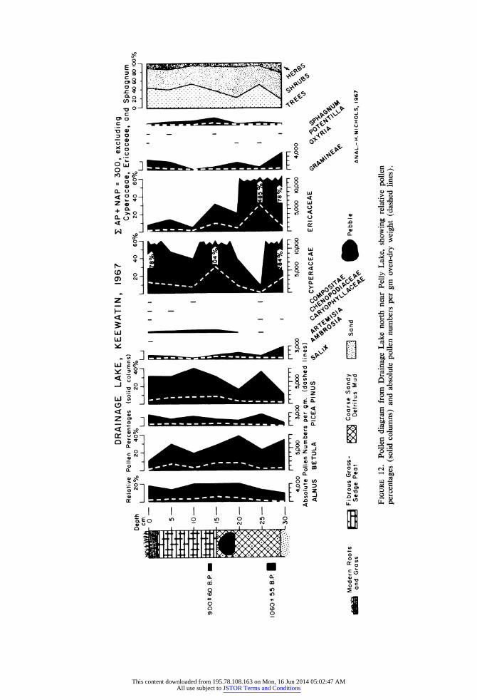
DRAINAGE LAKE
STRATIGRAPHY Surface grass-root mat with sedges rooted in un- humified grass-sedge peat; much sand. 0 - 4 cm Unhumified grass rootlet peat
with sedge fragments, with sand 4 - 15 cm Moderately humified coarse grass
rootlet peat, slightly sandy 15 - 25 cm Dark brown fine rootlet peat with
sand and silt. Pebble from 15 to 19 cm
25 - 28 cm Moderately humified coarse root- let peat with sand
28 - 29 cm Detritus mud with sand 29 cm + Coarse pale sand with iron stains
below. Cyperaceae stem at 29 cm
PALYNOLOGY
Organic accumulation began at 1,060 ? 55 BP (WIS-263) and ended shortly after 900 ? 60 BP (WIS-278) (Bender et al., 1968b). There were almost no changes in the absolute counts for Pinus and Picea pollen which is not surprising in view of the short period of accumulation (Figure 12). The percentages of pine and spruce were similar to those of the Pelly Lake diagram at about 900 ? 75 BP (WIS-245) (Bender et al., 1968a), and Pinus pollen was also in this case more frequent than Picea. The absolute values for these genera were, however, only about a third of the contem-
porary level at Pelly Lake, probably due to the faster rate of peat growth at Drainage Lake than at Pelly Lake.
In contrast to the unchanging representation of the tree and shrub pollen the figures for Cypera- ceae, Gramineae and Ericaceae exhibited large alterations. These taxa no doubt derived from very local sources around Pelly and Drainage lakes, and their remains formed the peat bed at Drainage Lake, so the variations in their counts may have
represented local overrepresentation of little sig- nificance. The following interpretation is, there- fore, very tentative.
The high values for Cyperaceae and Ericaceae at the base of the diagram may have reflected colonization by sedges (and some grasses) of formerly dry ground which became moist during the summer months. The accumulation of coarse detritus mud at this level in the profile points to locally wetter conditions. This was followed by an Ericaceae peak which may have recorded the spread of heaths such as Ledum palustre, Vaccini- um vitis-idaea, and Cassiope tetragona over the sand and gravel of the delta summit, which may
until then have been largely bare of vegetation as it is now (Figure 2). This may have resulted from the increased moisture postulated above, or possibly from a drier episode which may explain the reduced sedge values at this level (25 cm). Above 25 cm Ericaceae counts achieve only low levels, which contrast with higher Cyperaceae numbers in the absolute as well as relative values. Cyperaceae has a peak at 15 cm at the level at which there is a stratigraphic change from a basal sandy detritus mud to the upper grass-sedge peat. The peak of sedge pollen at 15 cm is probably the result of the invasion by sedges of the lakeside sampling site itself, but there is a suggestion from the Pelly Lake site that there was a local environ- mental change which occurred contemporaneous- ly. The Pelly Lake stratigraphy changed at 10 cm from a sedge peat to a fibrous grass-sedge peat, at 900 + 75 BP (WIS-245) (Bender et al., 1968a). Both this and the change from mud to peat at Drainage Lake at 940 ? 60 BP (WIS-278) (Bender et al., 1968b) may have reflected locally drier conditions. The desiccation of shallow ponds and marshy hollows, the conversion of shal- low lake margins to sedge meadows, and the in- vasion of marshes by less hydrophilous grasses may explain the palynological and stratigraphic changes seen at Drainage Lake and Pelly Lake at ca. 900 BP.
A large pebble (8 x 5 x 4 cm) was found em- bedded in the Drainage Lake peat monolith at 15 to 19 cm. It presumably moved down from the slightly higher ground around the lake as a re- sult of subaerial weathering, possibly under the influence of freeze-thaw processes. The weight of the pebble (413 gm) may have allowed it to sink below its original level of provenance into the older detritus mud. Its occurrence just below the stratigraphic change at 15 cm (ascribed above to drier conditions, and below more specifically to a drier, colder summer climate) may have been the result of the environmental changes at that level, but in the absence of other similar material at the same horizon the possibility cannot be stressed.
CLIMATIC IMPLICATIONS
It was suggested above that the accumulation of detrital mud at Drainage Lake at 1,060 ? 55 BP (WIS-263) (Bender et al., 1968b) occurred un- der relatively wet conditions, and that the grass- sedge peat above 15 cm grew under a drier cli- matic regime. The comparable evidence from Pelly Lake of increased absolute values of Picea
58 / ARCTIC AND ALPINE RESEARCH
This content downloaded from 195.78.108.163 on Mon, 16 Jun 2014 05:02:47 AMAll use subject to JSTOR Terms and Conditions
DRAINAGE LAKE, KEEWATIN, 1967 Relative Pollen Percentages
Depth 20% 20 40% cm. I I I , I J
tI v I l
900* 60 B.P. I I
1060t 55 B.P. I
Modern Roots and Grass
(solid columr 20 400/
1 1 1 1 1
i' 'l I,, I I , I 1 I ' ' ' I ' 4,000 5,oo 3,000 5,000
Absolute Pollen Numbers per gm. (dashed
ALNUS BETULA PICEA PINUS
Fibrous Grass- ? - _ . Sedge Peat Coarse Sandy
:XXd< Detritus Mud
ns) 40 60?,
1 I i I I A i I0
Xr-r*I I I
3,000 5,000 10,000 lines)
3 .Q,~, %Co oCYPERACEAE
Sand C<S an
S AP+ NAP = 300, excluding Cyperaceae, Ericaceae, and Sphagnum
/o 20 40 60% 0 20 40 60 80 100% I , I I I I J I . . . . I
F
I ,,W I I I I 5,000 10,000
ERICACEAE
Pebble
I
I
4,000
% 0
\p' \
ANAL.-H.NICHOLS, 1967
FIGURE 12. Pollen diagram from Drainage Lake north near Pelly Lake, showing relative pollen percentages (solid columns) and absolute pollen numbers per gm oven-dry weight (dashed lines).
I
I I
I
I
)<< >r
This content downloaded from 195.78.108.163 on Mon, 16 Jun 2014 05:02:47 AMAll use subject to JSTOR Terms and Conditions

and Pinus pollen before and at 900 + 75 BP (WIS-245) (Bender et al., 1968a) points to a northward advance of the forest limit and an in- crease in the southerly and/or westerly winds reaching the Pelly Lake area in summer from the Boreal forest. These winds would bring somewhat warmer moister air masses more frequently, though still not often, to northern Keewatin.
After 940 ? 60 BP (WIS-278) (Bender et al., 1968b), the drier conditions at Drainage Lake are indicative of colder drier summers which are com- patible with the evidence from Pelly Lake of de- creased flow of southerly/westerly air in summer after 900 ? 75 BP (WIS-245) and a southward retreat of the forest margin.
SUMMARY
The growth of the Pelly Lake deposit was initi- ated just at the end of a period of warm summers when the forest-tundra ecotone was relatively far north. The worsening of the summer climate after 3,360 -+ 70 BP (WIS-216) (Bender et al., 1968a) was reflected in a southward retreat of the ecotone, so that the maximum recorded southward extension of the tundra occurred at 2,080 ? 60 BP (WIS-292) (ibid.). This severely cold dry episode was followed by an amelioration which reached a maximum of summer warmth at 900 ? 75 BP (WIS-245) (ibid.) when the northern forest limit advanced northward. Very shortly after that date there was a sharp return to cold, dry summers at Pelly Lake and the forest retreat- ed south once more.
The implications of this climatic sequence for the contemporary plant ecology of this area are that the episodes of colder drier summers follow- ing 900 BP or prior to 2,100 BP may have been responsible for much of the degradation and de- struction of the plant cover of the top of the out- wash delta and for the accumulation of fine ma- terials at the base of that feature, in addition to the reduction of lake and pond levels and the forma- tion of the frost cracks and lag gravels. Fredskild (in preparation) has arrived at a similar conclu- sion for north Greenland; i.e., that the present sparse plant cover of the high arctic desert at Lake Klares0 in Peary Land developed more than 2,000 years BP as a result of "the climatic deterioration in the middle of the last millennium B.C."
The suggested climatic events described from
the Pelly Lake area are apparently parallel to and synchronous with the climatic history of Ennadai Lake and Lynn Lake (Nichols, 1967c, Figures 10 and 11). In addition, the sequence of colder summers after 3,400 BP which reached a maxi- mum of severity ca. 2,100 BP resembles the tim- ing and direction of the climatic deteriorations of the late sub-Boreal and early sub-Atlantic periods of northern Europe. The maximum of summer warmth at 900 BP coincided with the northern European early medieval climatic amelioration (Lamb, 1966). The subsequent cessation of peat growth at Pelly and Drainage lakes, probably due to a drier, colder climate, was synchronous with the European late medieval climatic deterioration (Lamb, 1966) which developed into the "Little Ice Age." It is known that the settlement of Greenland by Scandinavians in the 10th and 11th centuries A.D. occurred during an episode of warm summer climate, and that the decline and extinction of those colonies following the 14th century A.D. coincided with colder summers and the extension of sea-ice. Apart from written evi- dence for this climatic change there are the archea- ological observations that during the colder period graves were not dug as deeply as before, and that the earlier, deep graves and their contents later became permanently frozen; both these points in- dicate a rise of the soil permafrost level. This evi- dence therefore strengthens the tentative correla- tion of the climatic history of parts of central and northern Canada with that of northern Europe.
ACKNOWLEDGMENTS
Fieldwork was supported by ONR 1202(07), laboratory analyses by NSF grant GP 5572X to Dr. R. A. Bryson, Meteorology Department, Uni- versity of Wisconsin, Madison. I thank Dr. M. M. Bender for the radiocarbon assays, and Professor
Dr. L. Aario, Helsinki University, for discussion and comments on the manuscript. A summary of this research was read to the VIII INQUA Cong- ress, Paris, September 1969.
60 / ARCTIC AND ALPINE RESEARCH
This content downloaded from 195.78.108.163 on Mon, 16 Jun 2014 05:02:47 AMAll use subject to JSTOR Terms and Conditions

REFERENCES
Aario, L. 1940 : Waldgrenzen und subrezente Pollen-
spektren in Petsamo Lappland. Ann. Acad. Sci. Fenn., A, 54(8): 120 pp.
Ahrnsbrak, W. F. 1968 : Summertime radiation balance and en-
ergy budget of the Canadian tundra. University of Wisconsin, Meteorology Department, Tech. Report 37, Madi- son, Wisc., 50 pp.
Bartley, D. D. 1967 : Pollen analysis of surface samples of
vegetation from Arctic Quebec. Pollen et Spores, 9(1): 101-105.
Bartley, D. D. and Matthews, B. 1969 : A palaeobotanical investigation of post-
glacial deposits in the Sugluk area of northern Ungava, Quebec. Rev. Palae- obot. and Palynol. (in press).
Bender, M. M., Bryson, R. A., and Baerreis, D. A. 1968a: University of Wisconsin radiocarbon
dates IV. Radiocarbon, 10(1): 161- 168.
1968b: University of Wisconsin radiocarbon dates V. Radiocarbon, 10(2): 473- 478.
1969 : University of Wisconsin radiocarbon dates VI. Radiocarbon, 11(1).
Bird, J. B. 1967 : The physiography of Arctic Canada.
Johns Hopkins, Baltimore, Md., 336 pp.
Bryson, R. A., Irving, W. N., and Larsen, J. A. 1965 : Radiocarbon and soils evidence of for-
mer forest in the southern Canadian tundra. Science, 147: 46-48.
Craig, B. G. 1964 : Surficial geology of east-central district
of Mackenzie. Geol. Surv. Can., Bull. 99, 41 pp.
Dansgaard, W., Johnson, S. J., M0ller, J., and Langway, C. C.
1969 : One thousand centuries of climatic rec- ord from Camp Century on the Green- land ice sheet. Science, 166: 377-381.
Faegri, K. and Iversen, J. 1964 : Textbook of pollen analysis. Hafner,
New York, 237 pp. Franks, J. W. and Johnson, R. H.
1964 : Pollen analytic dating of a Derbyshire landslip: the Cown Edge landslides, Charlesworth. New Phytol., 63(2): 209-216.
Fredskild, B. 1967 : Palaeobotanical investigations at Ser-
mermiut, Jakobshavn, West Green- land. Medd. om Gr0nland, 178(4), 54 pp.
1969 : A postglacial standard pollen diagram from Peary Land, North Greenland. In preparation.
Hegg, O. 1963 : Palynological studies of a peat deposit
in front of the Thompson Glacier. Axel Heiberg Island Research Report, Mc- Gill University, Montreal, 217-219.
Kendrew, W. G. and Currie, B. W. 1955 : The climate of central Canada. Queen's
Printer, Ottawa, 194 pp. Lamb, H. H.
1966 : The changing climate. Methuen, Lon- don, 236 pp.
Larsen, J. A. 1965 : The vegetation of the Ennadai Lake
area, N.W.T.: studies in Subarctic and Arctic bioclimatology. Ecol. Monogr., 35: 37-59.
Nichols, H. 1967a: Pollen diagrams from sub-Arctic cen-
tral Canada. Science, 155: 1,665-1,668. 1967b: Central Canadian palynology and its
relevance to northwestern Europe in the Late Quaternary period. Rev. Palaeo- bot. and Palynol., 2: 231-243.
1967c: The postglacial history of vegetation and climate at Ennadai Lake, Kee- watin, and Lynn Lake, Manitoba. Eiszeitalter und Gegenwart, 18: 176- 197.
1967d: The disturbance of arctic lake sedi- ments by "bottom ice": a hazard for palynology. Arctic, 20(3): 213-214.
1967e: The suitability of certain categories of lake sediments for pollen analysis. Pol- len et Spores, 9(3): 615-620.
1969a: Chronology of peat growth in Canada. Palaeogeog., Palaeoclimat., Palaeoecol., 6: 61-65.
1969b: The Late Quaternary vegetational and climatic history of Porcupine Mountain and Clearwater Bog, Manitoba. Arctic and Alpine Res., 1(3): 155-167.
Prest, V. K., Grant, D. R., and Rampton, V. N. 1967 : The glacial map of Canada, Map
1523A. Geol. Surv. Can., Ottawa. Ritchie, J. C. and Lichti-Federovich, S.
1967 : Pollen dispersal phenomena in Arctic- Subarctic Canada. Rev. Palaeobot. and Palynol., 3: 255-266.
Terasmae, J. 1961 : Notes on late Quaternary climatic
changes in Canada. Ann. New York Acad. Sci., 95(1): 658-675.
1967 : Recent pollen deposition in the north- eastern district of Mackenzie (North- west Territories, Canada). Palaeogeog., Palaeoclimat., Palaeoecol., 3: 17-27.
Ms submitted June 1969
H. NICHOLS / 61
This content downloaded from 195.78.108.163 on Mon, 16 Jun 2014 05:02:47 AMAll use subject to JSTOR Terms and Conditions