
Landslide Hazard Map - alpter.net · Landslide susceptibility map is a model and an estimation of...
23
Landslide Hazard Map Dr. Blaž Komac Matija Zorn Anton Melik Geographical Institute ZRC SAZU Goriška brda 12. October 2006
-
Upload
vuongxuyen -
Category
Documents
-
view
217 -
download
0
Transcript of Landslide Hazard Map - alpter.net · Landslide susceptibility map is a model and an estimation of...

Landslide Hazard Map
Dr. Blaž KomacMatija Zorn
Anton Melik Geographical Institute ZRC SAZU
Goriška brda12. October 2006

Goriška brda – the rocks
Hilly region between the Idrija and Soča rivers.
Altitude: 300–800 m.
Flysch rocks (sandstone, marl, claystone, limestone, calcarenite), delimited by limestone in the North and alluvial sediments in the South:
upper Paleocene Kožbana flysch layers (turbiditesediments, includes limestone, breccia and conglomerate intrusions),
Lower Paleocene Medana flysch layers (sandstone, marls) are prone to landsliding.
Goriška brda12. October 2006

Fliessen – Flow – Flysch
Flysch is prone to landsliding because it:is built of different alternate rock layers may contain considerable amount of water and is relatively impermeable,it is layered and builds
hilly relief with steepslopes.
Goriška brda12. October 2006
(Calligaris 1999, 50)

Goriška brda12. October 2006
Landslides cause considerable damage in the Goriška brda region. Farmers repair the terraces for few weeks per year.
Most of the landslides are triggered on steep concave slopes due to increased water content being a consequence of high precipitation or human influence.
Farmers often repair small landslides themselves by canalizing water and thus leading it to lower areas in a safe way.
Landslides in Goriška brda

Landslides in Goriška brda“… Small landslides occur all over
the Goriška brda region and especially its central part where marls and steep slopes occur while shallow debris landslides mostly occur in the SW part of the region …" (Grimšičar 1962, 9).
Large, deep seated landslides are not so often and mostly occur in the lower parts of slopes. They are usually triggered by human impact or high waters of the streams.
Goriška brda12. October 2006

Input data: 800 landslides in 1998
Goriška brda12. October 2006
Heavy precipitation was recorded in Goriška brda in September and October 1998:
13. September – 100 mm
6. October – 175 mm (50 years reoccurence period)
28. September – 13. October = 433 mm.
m
m
High intense precipitation is one of the most important triggering factors. Critical (landsliding) precipitation intensity is about 100–150 mm/24 h or 130–180 mm/48 h in Slovenia.
More than 800 mostly shallow landslides were triggeredoccupying about 1,7 % of the area considered.

Susceptibility map elaboration method (based on the 1998 event data)
Goriška brda12. October 2006
Eight factors were taken into consideration:
lithology,
slope,
curvature,
dip of the strata,
stream power index,
wetness index,
maximum 24-hour precipitation,
land use.

Dempster-Shafer theory of evidence algorithm (Dempster 1969, Shafer 1990) was used to elaborate the map using the programs Idrisiand TAS.
First, the actual values are hierarhically compared to the factors, mentioned before. For each factor characteristic valuesare obtained which are then compared to the neighbouring values.
The final map shows landslide susceptibility (0–1), taking into account all the factors and the measured values. The final map is then produced – making classes on the basis of standard deviation.
Some factors and results shall be discused into detail:
Goriška brda12. October 2006Susceptibility map
elaboration method (based on the 1998 event data)
slemen.

In the Goriška brda region landslides usually appear on
NE or SW oriented concave slopes
having an inclination of about 20o
that are covered with vineyards.
On average, the landslides appear about 70 m belowthe ridges.
Goriška brda12. October 2006Susceptibility map
elaboration method (based on the 1998 event data)
slemen.

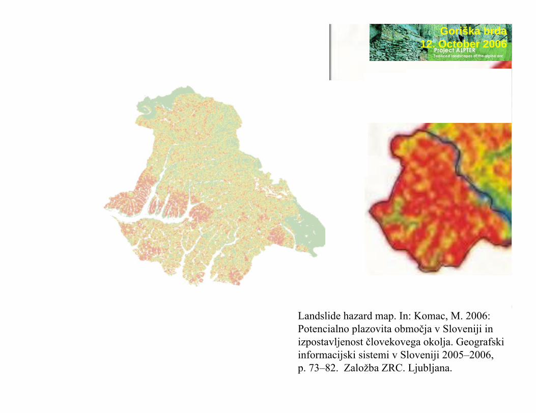
Goriška brda12. October 2006Landslide
susceptibility map (based on the 1998 event data)low
landslide susceptibility
high
Contents: Blaž Komac, Matija ZornCartography: Blaž Komac© landslide data: Občina Brda 2006© Anton Melik Geographical Institute ZRC SAZU 2006
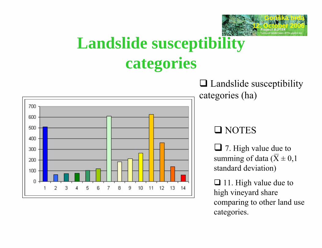
Landslide susceptibility categories
Goriška brda12. October 2006
Landslide susceptibility categories (ha)
NOTES
7. High value due to summing of data (X ± 0,1 standard deviation)
11. High value due to high vineyard share comparing to other land use categories.

Inclination of slopeGoriška brda
12. October 2006
Beside lithology, slope is the most important factor for landsliding.
Half of the landslides were triggered at 12–20º, a quarter at 6–12º, and a sixth at 20–32º. The correlation between frequency distribution of slope inclination and landslide areas is statistically imporatant.
COMPARISON: Haloze hills, 4. 8. 1989150–200 mm/24h, 5000/106 km2.0–5o : 0,0%6–10o : 3,7%11–15o : 24,6%16–20o : 32,0%21–25o : 20,3%26–32o : 13,5%above 32o : 5,9%

Landslides and dip of strata –measured and expected values (in degrees)
Dip of strata in theGoriška brda region
Dip of flysch strataGoriška brda
12. October 2006
The majority of landslides was triggered on theNE, SW and NW facing slopes.

Land use
Fields 2,94 2,63Vineyards 41,20 70,01Intensive Orchards 5,28 4,30Extensive Orchards 3,00 2,34Olives plantages 0,04 0,27Other plantages 0,00 0,00Extensive meadows 7,94 7,55overgrowing of forest 1,39 1,07Mixed use 1,99 0,80Forest 30,22 9,80Urbanised 5,87 1,23Not overgrown 0,01 0,00
Expected (%) measured(%)
Waters 0,14 0,00
Goriška brda12. October 2006
Total landslide susceptibility is rather high due to high share of vineyards. Landslide susceptibility is lower than expected in forests and urban areas.
COMPARISON (Haloze hills, 1989): 16% of the landslides were triggered in vineyards, 5% in the fields/orchards/forests. The average inclination of slope of landslides in forests was 23o, 14o in the fields and 18o
in the orchards.
“... Unexpected high number of landslides (5%) were triggered in the terraced vineyards – regarding to relatively small total area of terraces ...”(Natek 1990, 13).

planar curvatureGoriška brda
12. October 2006
40% of slopes are convex, 35% linear and 25% concave. The majority of landslide appeared below the upper convex parts of slopes that are far enough from the ridges.
The result are convex-concave slopes. Denudation and landslides prevail in the convex part while accumulation in the concave parts.
Landslides are very important morphogenetic factor controlling the evolution of upper parts of the valleys – typical flat-floored valleys appear. In the lower parts erosion is usually the predominant process.
COMPARISON (Haloze, 1989):44% of the landslides appeared in the middle parts of
the slopes. 1/3 of the landslides originated in the valley ends (Natek
1984, 147–148).

Most of the landslides were triggered in the middle parts of slopes just below their upper – convex parts.
Blue colorshows concave relief forms, red colorconvex relief forms and yellow colorlinear slopes.

Length of slopesThe landslides were triggered 70 metres below the ridges on average (40–100 m).
The quantity of (surficialand ground) water flowing down the slopes is big enough to changethe characteristics of thematerial in the distance offew 10 m from the ridges .
Goriška brda12. October 2006
length of slopes (m)
The majority of slopes are rather short:a quarter of them is shorter than 20 mhalf of them shorter than 50 ma quarter longer than 100 m).

TerracesInclined slopes are the most suitable relief type for viticulture but they are also areas prone to landsliding on the other hand.
Winegrowers have to adapt to the situation. That is why almost half of the terraces are built on the landslide-prone areas and only a quarter of them on less hazardous areas.
The terraces comprise more than 40% of the territory in Goriška brda.
Goriška brda12. October 2006

RoadsAbout 1/10 (~10 km) of the main roads are built
on the areas prone to landsliding and about ¾ are relatively safe from them.
Almost a quarter of roads are endangered by landslides and more than a half (54 km) of them are safe from landsliding.
Goriška brda12. October 2006
main roadsroadsagricultural roads
More than two thirds of agricultural roads are endangered by landslides. One quarter of them is highly endangered, and one quarter (110 km) is safe from landsliding.

Landslide susceptibility map is a model and an estimation of theeffects of geomorphic processes. Its reliability depends on thequality of the data used, the method and the geomorphologicalknowledge of the producer.
+ The model includes high number of landslides that were triggered at known conditions (precipitation amount). The most important controlling factors are included. The data are not weighed but compared by a hierarhic statistical method. The map is useful for further detailed field mapping.
– The map is a model and thus only partly describes nature and natural processes. It is based on one (time) series of data. The data are not 100% reliable as they were not collected by scientists.
Goriška brda12. October 2006Model /map reliability

“... Gentle slopes facing SW and having a thin layer of debris are safe from landslides. That is why there are not a lot of landslides in northern Goriška brda ...” (Grimšičar 1962, 8).
Landslides are often triggered by the activity of man. For example, more than half half of the landslides in Haloze (1989) were indirectly caused by human activity (Natek 1990).
About ¾ of the area put into consideration is more or less prone to landsliding. Slope, dip of strata and depth of mobile material(debris) seem to be the most important controlling factors.
Terrace and road building shall follow the guidelines and historic experience of inhabitants, farmers. Building process should be carefully pre-considered from the natural, agricultural and economic point of view.
Goriška brda12. October 2006Conclusion
Goriška brda12. October 2006
Landslide hazard map. In: Komac, M. 2006: Potencialno plazovita območja v Sloveniji in izpostavljenost človekovega okolja. Geografski informacijski sistemi v Sloveniji 2005–2006, p. 73–82. Založba ZRC. Ljubljana.