Landscape Character Study - City of Bunbury and Building/Landscape...to developments up to eight...
31
2.4 Central Business District CBD Core Marlston Hill Marlston Waterfront Central Coast Koombana Bay
Transcript of Landscape Character Study - City of Bunbury and Building/Landscape...to developments up to eight...

2.4 Central Business District
CBD Core
Marlston Hill
Marlston Waterfront
Central Coast
Koombana Bay

2:35
CBD Core
Central Business District
Aerial View
Boundaries
Local Area CharacterVictoria Street is the CBD’s ‘main street’ and is characterised by a significant proportion of buildings that are considered to positively contribute to an established and attractive streetscape particularly with regard to buildings that have cultural heritage value. Their is a comfortable human scale at street level created by the presence of first floor canopies that create a continuos covered walkway and gives the streetscape a sense of formality; the upper storeys are generally two-three storey at lot boundary. These buildings are considered to be in harmony, they address the street and one another and create a rhythmic streetscape.Together with the street trees and street furniture that enclose the main street space, the built form creates a sense of place. The high level of human activity in the main street and the presence of a ‘cappuccino strip’, also contributes to a sense of vitality and interaction in the CBD.The three waters surrounding the City together with significant built features characterise the City as a significant regional centre. This invokes an impressive sense that the City is an important and diverse geographic area and commercial centre, a City, which has been developed with major built infrastructure amongst vast and unique natural water settings with an attractive, bustling and interactive CBD.
Carey Street on the north side, Blair Street on the west, down to and including the south
to Cornwall and Money Streets and up Molloy Street on the west.
Activity Centres
Public Art WorksLeft to right: Floating Stone by Richard Williamson, Brother and Sister by Russell Sheridan, Forest Trees by Howard Taylor, The Gateway by Mary Knott, & Fold by Don Walters.
Character Mapping
Strategic Regional Centre Left to right: Prinsep Street, Victoria Street southern end, Victoria Street north of Prinsep Street, arcade between Prinsep and Stephen Streets.

CBD Core
2:36Central Business District
Character MappingCity Vision StrategyStrategic Regional Centre Vision Focus Area; and Central Business District Investigation AreaObjectives and Strategies relevant to the Strategic Regional CentreCBD1: Allocate sufficient resources for the planning and development of the Leschenault Inlet Regional Park so that the area is established as a major tourist and recreation attraction.CBD2: Require the protection and tourism/recreational enhancement of the White Mangroves as part of any planning and development of theNorth Shore.CBD3: Require planning policies and projects for development to incorporate consideration of key landmarks with a view to enhancing their role in orientation and defining character and amenity of the City.CBD5: The management arrangements for the Leschenault Inlet Regional Park need to ensure that the viability of the estuarine environment is the highest priority.CBD6: Plan for a change in priority between cars and pedestrians in favour of pedestrians and identify opportunities for street based activities.CBD7: Ensure that planning policies and development control provisions adequately provide for the conservation and protection of heritage values.CBD8: In accordance with the Bunbury Community Safety and Crime Prevention Plan the design of buildings, streetscapes and open spaces is to be influenced by encouraging the identification of risks/hazards through safety auditing of places and development proposals in order to inform public sector capital works/maintenance programmes and private sector
development initiatives.CBD9: Prepare a sport and recreation strategy for Greater Bunbury that addresses the needs of all age groups and identifies ways of supporting clubs and community groups.CBD10: Identify available sites for tourist development and establish the criteria for the site mix of freehold subdivision and tourism, height and management.CBD16: That the Strategic Regional Centre be assessed to establish the constraints and opportunities for commercial development.CBD17: That a staged CBD streetscape strategy be programmed by Council.CBD18: That Blair Street remains connected to Koombana Drive.CBD19: That reducing Blair Street from four lane divided to two lane divided between Haley Street and Koombana Drive (both lanes removed from the Inlet side) with enhanced east/west pedestrian connections and traffic calming be developed for further consideration. The Clifton/Blair Street roundabout needs to be redesigned to take account of the downgrading of Blair Street.CBD20: That Symmons Street be developed as a key pedestrian and visual connection between the cappuccino strip north to Clifton Street and the Inlet.CBD22: That the central bus station be retained.CBD23: That the operation of the central bus station be reviewed to improve pedestrian linkages and reinforce the terminus as a tourist destination and major arrival point. Alternative locations for bus storage need to be identified.CBD24: Retain the option of an intermodal transport facility at the Eelup Roundabout and undertake a detailed cost/benefit analysis to establish that there will be an improvement in economic, social
and environmental outcomes.CBD25: That decked parking sites be planned to service the northern, central and southern sectors of the CBD.CBD27: That further research be undertaken to establish the appropriate location of a decked parking site to service the northern sector of the CBD.CBD28: That the State Coastal Planning Policy Amendment 62 relating to height is supported where the maximum height for coastal areas (including the Bay and Inlet) should be five storeys or 21 metres and under certain conditions and subject to criteria including broad community support, consideration may be given to developments up to eight storeys or 32 metres. CBD29: That height in the commercial core of the CBD defined as both sides of Wittenoom, Stephen, Victoria and Carey Streets is determined on the basis of complementary development with the Bunbury Tower and the Old Silos redevelopment. Areas outside of the commercial core to be planned and designed within the two to five storey range and depending on topography, accessibility and community acceptance up to eight storeys.CBD34: That development of the foreshore areas must be low impact with an emphasis on civic, cultural and tourist orientated uses. Other development opportunities may be considered following the public release and community feedback on the Bunbury Waterfront Project prepared by Landcorp.CBD36: That the City in partnership with Landcorp undertake further planning and financial analysis to establish the mix of uses that meet objectives and strategies that seek to improve connectivity between the CBD and the Harbour, provide for a broad range of tourism and recreation experiences, protect and enhance heritage values and build on the existing facilities that currently service small craft to large ships.
Landmarks / FeaturesLeft to right: The Art Gallery , The Bird Cage, The Rose Hotel, The Bunbury Tower, the City Library an the Council Chambers
Visual Diaries CBD Core
2:37Central Business District
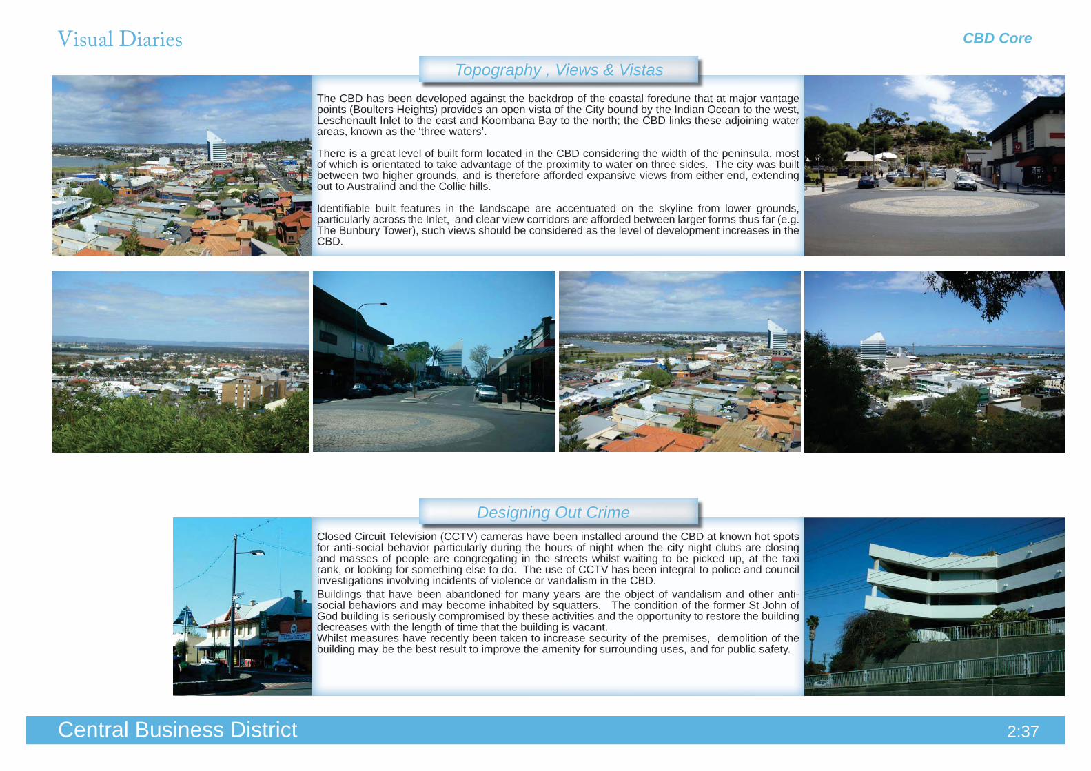
Topography , Views & VistasThe CBD has been developed against the backdrop of the coastal foredune that at major vantage points (Boulters Heights) provides an open vista of the City bound by the Indian Ocean to the west, Leschenault Inlet to the east and Koombana Bay to the north; the CBD links these adjoining water areas, known as the ‘three waters’.
There is a great level of built form located in the CBD considering the width of the peninsula, most of which is orientated to take advantage of the proximity to water on three sides. The city was built between two higher grounds, and is therefore afforded expansive views from either end, extending out to Australind and the Collie hills.
Identifiable built features in the landscape are accentuated on the skyline from lower grounds, particularly across the Inlet, and clear view corridors are afforded between larger forms thus far (e.g. The Bunbury Tower), such views should be considered as the level of development increases in the CBD.
Closed Circuit Television (CCTV) cameras have been installed around the CBD at known hot spots for anti-social behavior particularly during the hours of night when the city night clubs are closing and masses of people are congregating in the streets whilst waiting to be picked up, at the taxi rank, or looking for something else to do. The use of CCTV has been integral to police and council investigations involving incidents of violence or vandalism in the CBD.Buildings that have been abandoned for many years are the object of vandalism and other anti-social behaviors and may become inhabited by squatters. The condition of the former St John of God building is seriously compromised by these activities and the opportunity to restore the building decreases with the length of time that the building is vacant.Whilst measures have recently been taken to increase security of the premises, demolition of the building may be the best result to improve the amenity for surrounding uses, and for public safety.
Designing Out Crime

Visual Diaries CBD Core
2:38Central Business District
Street Trees & Verge Treatments
Signage
Road LayoutStirling Street (west of Spencer Street) is a 24.4 metre road (Neighbourhood Connector) with a speed limit of 50 km, a central median, parallel parking, an unmarked cycle lane, single lane traffic in each direction with a signaled intersection at one end and a roundabout at the other end.There is pedestrian access on both sides of the road with breaks in the median to cross to the opposite side of the street.
The ANZAC Memorial Park has been designed to accentuate the monument. The palm trees that are arranged in symmetry either side of the monument are particularly significant from an aerial perspective and they frame the statue complimenting and drawing attention to its scale and significance. All of the trees in the park are on the State Heritage Register as an integral part of the success of the monument.
The Callitris species planted on the corner of Stephen Street and Victoria Street drop quantities of pine needles onto the footpath and in the garden beds which then end up in the drains. This requires constant maintenance to ensure public safety and tidiness.Whilst mature trees are appreciated for their contribution to the streetscape, it is good practice to select street tree species for their low maintenance qualities, particularly in areas where they are in proximity to high pedestrian activity.
Businesses advertising on sandwich boards out the front of their shops clutter the street and can be hazardous to pedestrians having to walk around them.In winter when Victoria Street experiences high wind speeds, they often fall over and blow around which poses an even greater risk to people, furniture, buildings and parked cars.
The Grand Cinema Complex on Victoria Street has one simple statement across the front parapet of the shade structure that protrudes over the footpath. Further set back off the street where it is less dominant and more directed at pedestrians is the signage of individual tenancies. The result is tidier than multiple competing advertisements at street level.
The section of Stirling Street that runs between Spencer Street and Blair Street is approximately 160 metres between intersections, and consists of a roundabout, a signalled pedestrian crossing, two car park entrances and a one way street entrance and both ends are signal controlled.The level of activity that occurs in this strip is not well arranged and often banks up traffic. There are high levels of directional signage, traffic lights and general dissonance in connectivity.
Visual Diaries CBD Core
2:39Central Business District
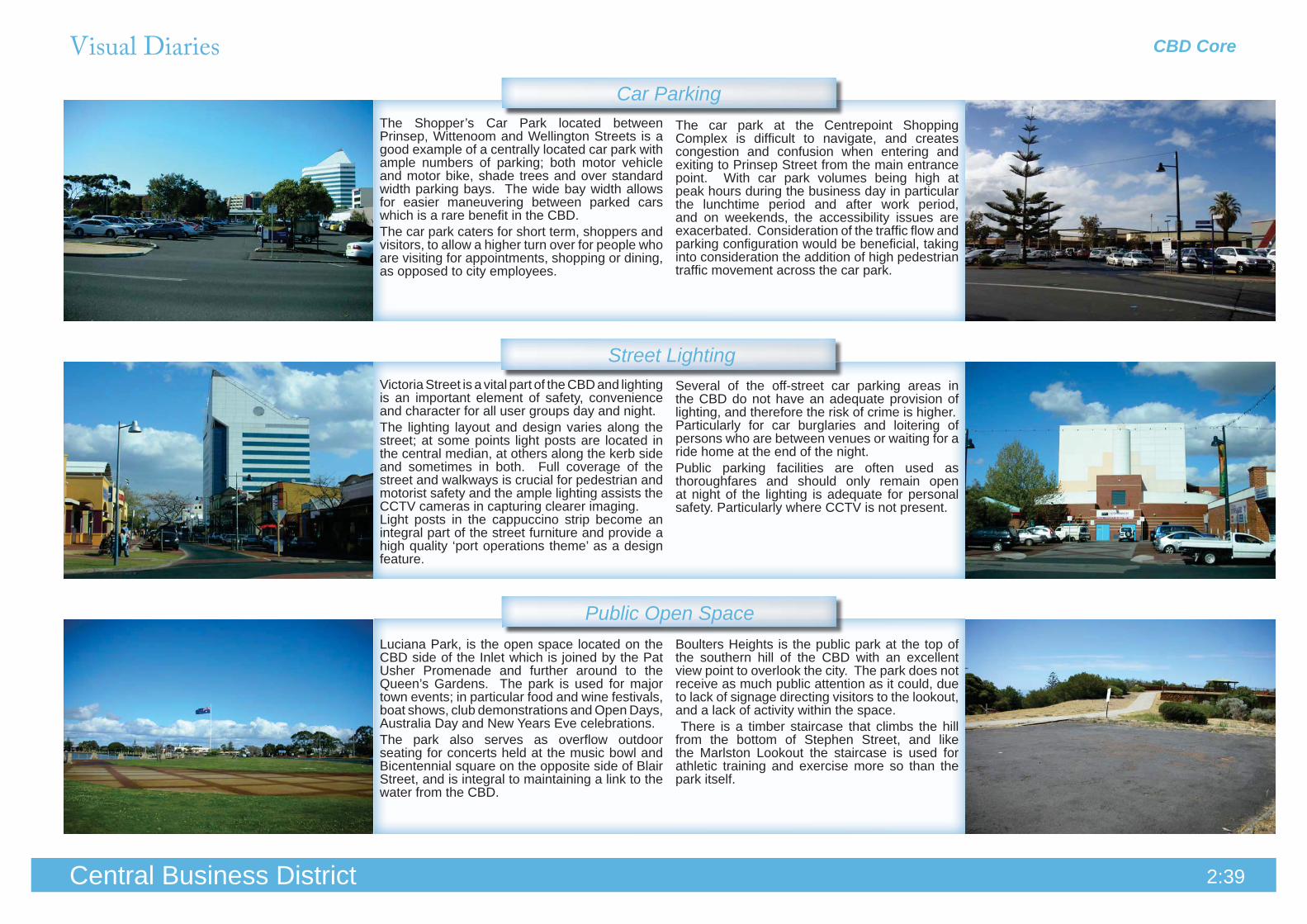
The Shopper’s Car Park located between Prinsep, Wittenoom and Wellington Streets is a good example of a centrally located car park with ample numbers of parking; both motor vehicle and motor bike, shade trees and over standard width parking bays. The wide bay width allows for easier maneuvering between parked cars which is a rare benefit in the CBD.The car park caters for short term, shoppers and visitors, to allow a higher turn over for people who are visiting for appointments, shopping or dining, as opposed to city employees.
Victoria Street is a vital part of the CBD and lighting is an important element of safety, convenience and character for all user groups day and night. The lighting layout and design varies along the street; at some points light posts are located in the central median, at others along the kerb side and sometimes in both. Full coverage of the street and walkways is crucial for pedestrian and motorist safety and the ample lighting assists the CCTV cameras in capturing clearer imaging.Light posts in the cappuccino strip become an integral part of the street furniture and provide a high quality ‘port operations theme’ as a design feature.
Luciana Park, is the open space located on the CBD side of the Inlet which is joined by the Pat Usher Promenade and further around to the Queen’s Gardens. The park is used for major town events; in particular food and wine festivals, boat shows, club demonstrations and Open Days, Australia Day and New Years Eve celebrations. The park also serves as overflow outdoor seating for concerts held at the music bowl and Bicentennial square on the opposite side of Blair Street, and is integral to maintaining a link to the water from the CBD.
Boulters Heights is the public park at the top of the southern hill of the CBD with an excellent view point to overlook the city. The park does not receive as much public attention as it could, due to lack of signage directing visitors to the lookout, and a lack of activity within the space. There is a timber staircase that climbs the hill from the bottom of Stephen Street, and like the Marlston Lookout the staircase is used for athletic training and exercise more so than the park itself.
Several of the off-street car parking areas in the CBD do not have an adequate provision of lighting, and therefore the risk of crime is higher.Particularly for car burglaries and loitering of persons who are between venues or waiting for a ride home at the end of the night. Public parking facilities are often used as thoroughfares and should only remain open at night of the lighting is adequate for personal safety. Particularly where CCTV is not present.
The car park at the Centrepoint Shopping Complex is difficult to navigate, and creates congestion and confusion when entering and exiting to Prinsep Street from the main entrance point. With car park volumes being high at peak hours during the business day in particular the lunchtime period and after work period, and on weekends, the accessibility issues are exacerbated. Consideration of the traffic flow and parking configuration would be beneficial, taking into consideration the addition of high pedestrian traffic movement across the car park.
Car Parking
Street Lighting
Public Open Space

Visual Diaries
2:40Central Business District
Pedestrian & Bicycle Pathways
The taxi rank on the corner of Symmons Street is the only one in the CBD and experiences its highest volume of patrons in the late night period.The current shelter that overhangs the queuing area does not provide adequate protection from the high speed winds and rain that Symmons Street experiences.
These modern park benches are a part of the coordinated street furniture that is in keeping with the ‘port operations’ theme along the main street. The combined steel and timber individually shaped seats are held together on a single frame but appear to define a sense of personal space for the occupants, and each seat has an ergonomically designed back rest.The design is reminiscent of the cylindrical silo shape, evident in the shadow that falls across the pavement.
The office redevelopment at the corner of Clifton and Victoria Streets had to accommodate an existing raised floor level that required upgrading to current Australian Standards for disabled access incorporating a new access ramp. This included resurfacing of the pedestrian access from the pram ramp to the lot boundary of the property and tactile surface indicators at the base of the front steps and access ramp, to coordinate and guide the approach to the building for the visually impaired.
Footpath surfaces should be consistent along major pedestrian thoroughfares, in the public realm. The design and finish is important to achieve a continuous streetscape and higher level of attractiveness. When a developer contribution is required to upgrade paving, care should be taken to incorporate consistent materials, colour schemes and paving patterns. All surfaces should comply with Australian Standards for: grade, material, non-slip and tactile surfaces, level changes, wheel chair access and pram ramps at road crossings and building entrances.
Alleyways are predictable routes that enable attackers to easily identify where the user is going to go. In most instances alleyways are constructed for access to private properties or rights of way that are just not closed off from the public and become common thoroughfares. Factors to consider for increasing safety include:
additional lighting• avoiding locating a.t.m’s, public phones, and public toilets in such locations,• choice of vegetation and maintenance regimes and • restricted access• use of fencing• locking off areas during times of low usage•
(Designing Out Crime Planning Guidelines 2006:41)
CBD Core
Street Furniture
Alleyways

2:41Central Business District
The rear of the Entertainment Centre does not address Victoria Street in a receptive manner. The solid wall of an equivalent to three storeys is windowless and contains only the service entrances which back onto a small car parking area.The building forms a part of the Victoria Street frontage, and it should interact with the main street in a manner greater than just directing patrons around the side of the building, past the backs of tenancies and through the car park.There is a high level of vandalism to cars and incidences in the vicinity of the thoroughfare in general.
The Centrelink car park on Prinsep Street is a good example of desired outcomes for access to and from an inner city lot. The open frontage has clear sight lines and low vegetation with a wide double crossover, that allows for ample space for vehicles to pass entering and exiting from either direction off the street.
The foreshore carpark off of Blair Street opposite the Entertainment Centre is essentially an over flow car park for the entertainment centre and theatre complex as well as being for inner city employees on a week day basis.The ingress/egress arrangement is a single access point close to the intersection of Koombana Drive which is left entry only. All traffic must enter off of the roundabout, making it difficult to enter for Blair and Clifton Street traffic when there is queuing traffic at the Koombana Drive entry.
The housing estate in the St John’s special use area known as Bury Hill, has shared car parking area that is central to the upper level of development. The houses are separated from the communal area by a concrete rendered wall that has a wave-like formation and marine motifs incorporated on the public side of the wall. The wall features up lighting and relief sculptures attached to the wall. The wall varies in masonry finishes and features old timber jetty pylons in the entry statement.This fencing has formed an integral part of the development and provides an interpretive design theme throughout the estate.
Where the land has been subdivided for residential development at the top of Parkdale Street, the need to retain the land on the eastern slope has resulted in a high limestone retaining wall which is broken up by a terrace half way down that is landscaped and then continue to the lowest point. The expanse of limestone wall dominates the open views from Wexford Lane and the surrounding residential area. This may only be in the interim period until the development reaches completion, which may be a number of years away.
The front façade of the Entertainment Centre addresses Blair Street in an open and well integrated manner for pedestrians and vehicles.The building is set back from the road with landscaping, a vehicle thoroughfare and delineated pedestrian entrance that continues over the road from the foreshore car park. The building façade has lots of window area, animated signage and a clearly defined entrance and the area is well lit.
Access & Crossovers
Boundaries & Retaining Walls
CBD Core
Street Activation
Visual Diaries

CBD CoreVisual Diaries
2:42Central Business District
Building Style
Building Setback
The residential tower on Prinsep Street has been designed to orientate as much window area and private open space as possible to the north for direct solar access.The balconies form a canopy which provides shade and undercover outdoor areas to the northern façade, and allowing ample natural lighting to habitable areas of the apartments and stair wells.
The Lord Forrest Hotel is adjacent to the Bunbury Tower on Symmons Street and both structures are amongst the tallest buildings in Bunbury.However the Lord Forrest has several less storeys than the tower, and evidently, there is glare bouncing off of the tower which is reflected into the rooms on the eastern side of the hotel.The building was constructed in the late 1980’s and reflects a building style of its time.
The Ommanney Building is a post 2000 development in the CBD with three storeys of commercial mixed uses. The building design is reminiscent of some of the existing heritage buildings in its method of utilising the corner allotment as a design feature by wrapping the building around the corner so that it addresses both street frontages.The ornate façade details compliment the simple form and give the appearance that the building is greater than its actual height.
The Reef Hotel was built in 1896 as ‘Gordon’s Hotel’. Since the early 1990’s it has been painted in loud shades of orange, pink, black, red, grey, purple and green. The historical building once characterised for its uniquely angled eastern wall, has diminished in historical value and has since been approved for demolition.
Building OrientationThe Bunbury Tower is a dominating feature in the CBD as it stands alone, taller than any other building in the city. The expanse of tinted glass that is on every face of the building has an impact on surrounding buildings and for people walking by. Due to the expansive of glass on the western side, the Lord Forrest is more afflicted because of its proximity, it would have been more beneficial if the tower were constructed out of materials with greater absorptive than reflective properties.
There is a strong consistency and sense of intimacy created along the ‘cappuccino strip’ of Victoria Street where all the buildings have a zero lot line setback.This allows interaction with the streetscape and open fronted cafes provide activity and energy to the street.

Visual Diaries CBD Core
2:43Central Business District
Building Materials & ConstructionThe CoB Library, built in 2008, is at the south end of Victoria Street. The external façade is predominantly a durable compressed cement fibre material, that is used in different colours and finishes to provide variations in the design.The building has good northerly orientation and is predominantly glass on both the northern and eastern facades. This aspect allows passive solar access to both the first and ground floor, to maximise energy efficiency.
The adjacent St John of God hospital site is an example of a material palette and style demonstrative of its era. The brown brick work and alternating white concrete panels (balconies/ verandahs) are a contrasting image to the adjacent library. The condition of the building has deteriorated with age and it has not been occupied since 1999. There is opportunity, (currently being considered) to refurbish the existing building or demolish the shell and redevelop the site.
The intersection on the corner of Victoria Street and Wellington Street consists of the Hands Building (76-78 Victoria Street), Lotteries West House (101 Victoria Street), Cronshaws (103 Victoria Street) and the Rose Hotel (27 Wellington Street). This intersection exemplifies the historical “main street” character of Bunbury. The building bulk and scale is consistent on all four corners, the colour schemes are neutral and each building addresses the intersection on both street frontages.
There is a lot of building stock along Victoria Street that has not been maintained for its heritage value and contribution to character, and these buildings are likely to be redeveloped in the future. Adaptation projects are already under way for existing buildings to be converted into mixed use developments such as retail / office floor space with residential floors above.
Building Character
Marlston Hill
Activity Centres
Public Art Works
2:44Central Business District
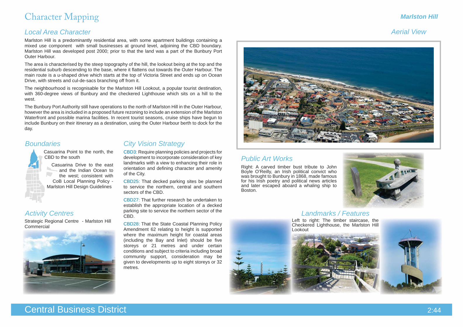
Aerial ViewLocal Area Character
Landmarks / Features
City Vision StrategyBoundariesCBD3: Require planning policies and projects for development to incorporate consideration of key landmarks with a view to enhancing their role in orientation and defining character and amenity of the City.CBD25: That decked parking sites be planned to service the northern, central and southern sectors of the CBD.CBD27: That further research be undertaken to establish the appropriate location of a decked parking site to service the northern sector of the CBD.CBD28: That the State Coastal Planning Policy Amendment 62 relating to height is supported where the maximum height for coastal areas (including the Bay and Inlet) should be five storeys or 21 metres and under certain conditions and subject to criteria including broad community support, consideration may be given to developments up to eight storeys or 32 metres.
Casuarina Point to the north, the CBD to the south
Casuarina Drive to the east and the Indian Ocean to the west; consistent with
CoB Local Planning Policy - Marlston Hill Design Guidelines
Marlston Hill is a predominantly residential area, with some apartment buildings containing a mixed use component with small businesses at ground level, adjoining the CBD boundary. Marlston Hill was developed post 2000; prior to that the land was a part of the Bunbury Port Outer Harbour. The area is characterised by the steep topography of the hill, the lookout being at the top and the residential suburb descending to the base, where it flattens out towards the Outer Harbour. The main route is a u-shaped drive which starts at the top of Victoria Street and ends up on Ocean Drive, with streets and cul-de-sacs branching off from it. The neighbourhood is recognisable for the Marlston Hill Lookout, a popular tourist destination, with 360-degree views of Bunbury and the checkered Lighthouse which sits on a hill to the west.The Bunbury Port Authority still have operations to the north of Marlston Hill in the Outer Harbour, however the area is included in a proposed future rezoning to include an extension of the Marlston Waterfront and possible marina facilities. In recent tourist seasons, cruise ships have begun to include Bunbury on their itinerary as a destination, using the Outer Harbour berth to dock for the day.
Left to right: The timber staircase, the Checkered Lighthouse, the Marlston Hill Lookout
Strategic Regional Centre - Marlston Hill Commercial
Right: A carved timber bust tribute to John Boyle O’Reilly, an Irish political convict who was brought to Bunbury in 1868, made famous for his Irish poetry and political news articles and later escaped aboard a whaling ship to Boston.
Character Mapping

Visual Diaries
2:45Central Business District
Road Layout
Topography, Views & Vistas
Street Trees & Verge Treatments
Marlston Hill
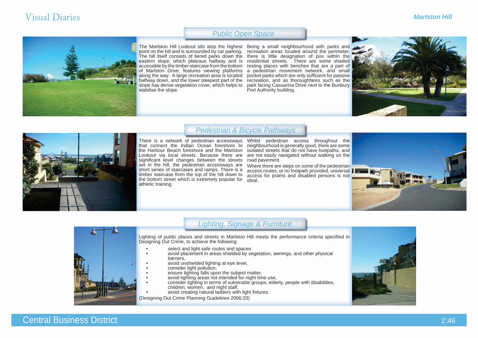
The road layout is a curvilinear pattern. The main access street has a central median and on street parking, however; there is no separate cycle lane and there is no bus route through the suburb.Most of the streets end in cul-de-sacs or provide local traffic thoroughfares for easier navigation to the outer streets where there is low numbers of general traffic.
The topography is steep and varies by twenty metres in contour from highest to lowest point. The landform has not been altered too greatly from its original state during the time that the land was used for Port activity. Some cut and fill had to occur in order to achieve the road layout, in particular Marlston Drive. As a result the suburb required significant retaining walls along the main route.The view from the top of the Marlston Lookout includes a 360° view of Bunbury, the Inner and Outer Harbours, the Indian Ocean and the Collie Hills - visible in the background.
The Hibiscus tiliaceus (Cotton Wood) has been used as an ornamental street tree in Marlston Hill, which is aesthetically pleasing for its structure, bright foliage and yellow and orange flowers. The trees are fast growing and sturdy, making them perfect for use in new suburbs.
This road forms a tight curve around the top of the hill, and is built up to the street with boundary retaining walls. The effect is an enclosed space with limited sight lines. It is unclear as to whether the paved areas to the high side of the street are for parking or pedestrian access, however it is not a continuous strip, as the path is broken up by tree plantings in rubble beds, which is possibly to aide in the slowing down and soakage of surface run off. Land owners generally take ownership of the wide verge adjacent to their own properties.
Landscaping that abuts a pedestrian footpath should not overhang the path, and should not be of a height that obscures visibility for the pedestrian, or create hiding places.Knee height landscaping is more appropriate, or alternatively; tree species that have an overhead canopy and no under storey, teamed with a ground cover or mulched garden bed. Species that drop plant matter create excessive maintenance requirements, and end up blocking drainage.
Marlston HillVisual Diaries
2:46Central Business District
Pedestrian & Bicycle Pathways
Lighting, Signage & Furniture
Public Open Space
Whilst pedestrian access throughout the neighbourhood is generally good, there are some isolated streets that do not have footpaths, and are not easily navigated without walking on the road pavement. Where there are steps on some of the pedestrian access routes, or no footpath provided, universal access for prams and disabled persons is not ideal.
There is a network of pedestrian accessways that connect the Indian Ocean foreshore to the Harbour Beach foreshore and the Marlston Lookout via local streets. Because there are significant level changes between the streets set in the hill, the pedestrian accessways are short series of staircases and ramps. There is a timber staircase from the top of the hill down to the bottom street which is extremely popular for athletic training.
Lighting of public places and streets in Marlston Hill meets the performance criteria specified in Designing Out Crime, to achieve the following:
select and light safe routes and spaces• avoid placement in areas shielded by vegetation, awnings, and other physical •
barriers,avoid unshielded lighting at eye level,• consider light pollution,• ensure lighting falls upon the subject matter,• avoid lighting areas not intended for night time use,• consider lighting in terms of vulnerable groups, elderly, people with disabilities, •
children, women, and night staff, avoid creating natural ladders with light fixtures.•
(Designing Out Crime Planning Guidelines 2006:33)
The Marlston Hill Lookout sits atop the highest point on the hill and is surrounded by car parking. The hill itself consists of tiered parks down the eastern slope, which plateaus halfway and is accessible by the timber staircase from the bottom of Marlston Drive, features viewing platforms along the way. A large recreation area is located halfway down, and the lower steepest part of the slope has dense vegetation cover, which helps to stabilise the slope.
Being a small neighbourhood with parks and recreation areas located around the perimeter, there is little designation of pos within the residential streets. There are some shaded resting places with benches that are a part of a pedestrian movement network, and small pocket parks which are only sufficient for passive recreation, and as thoroughfares such as the park facing Casuarina Drive next to the Bunbury Port Authority building.
Visual Diaries
2:47Central Business District
Gardens & Landscaping
Boundaries & Retaining Walls
Access & Crossovers
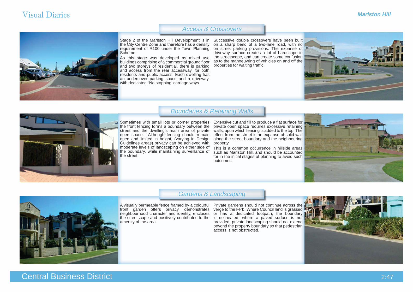
Stage 2 of the Marlston Hill Development is in the City Centre Zone and therefore has a density requirement of R100 under the Town Planning Scheme.As this stage was developed as mixed use buildings comprising of a commercial ground floor and two storeys of residential, there is parking and access from the rear accessway, for both residents and public access. Each dwelling has an undercover parking space and a driveway, with dedicated “No stopping’ carriage ways.
Successive double crossovers have been built on a sharp bend of a two-lane road, with no on street parking provisions. The expanse of driveway surface creates a lot of hardscape in the streetscape, and can create some confusion as to the manoeuvring of vehicles on and off the properties for waiting traffic.
Sometimes with small lots or corner properties the front fencing forms a boundary between the street and the dwelling’s main area of private open space. Although fencing should remain open and limited in height, (varying in Design Guidelines areas) privacy can be achieved with moderate levels of landscaping on either side of the boundary, while maintaining surveillance of the street.
Extensive cut and fill to produce a flat surface for private open space requires excessive retaining walls, upon which fencing is added to the top. The effect from the street is an expanse of solid wall along the street boundary and the neighbouring property. This is a common occurrence in hillside areas such as Marlston Hill, and should be accounted for in the initial stages of planning to avoid such outcomes.
A visually permeable fence framed by a colourful front garden offers privacy, demonstrates neighbourhood character and identity, encloses the streetscape and positively contributes to the amenity of the area.
Private gardens should not continue across the verge to the kerb. Where Council land is grassed or has a dedicated footpath, the boundary is delineated; where a paved surface is not provided, private landscaping should not extend beyond the property boundary so that pedestrian access is not obstructed.
Marlston Hill

Marlston HillVisual Diaries
2:48Central Business District
Building Style & Character
Building Setback & OrientationBuilding setback requirements for Marlston Hill range from 1.5 metres minimum to 6 metres front setback. Most of the streets have a consistent 4 metre setback, which creates a harmonious street pattern. Protrusions for garaging and balconies create variations that add some relief to the streetscape when executed in a complementary style that is not excessive.
Side and rear setbacks are determined by the R-Codes (unless otherwise specified by a Design Guideline) and should only be considered if they protect the amenities of adjoining properties, including, where appropriate:
Adequate direct sun to building and • appurtenant open spaces;Adequate daylight to major openings to • habitable rooms; andAccess to view of significance. •
(State Planning Policy 3.1, Residential Design Codes, Part 6:20)
Modern coastal designs usually incorporate curved roof lines for their aesthetic value or to mimic natural coastal elements. The high curved canopies shade the western and northern facades providing a pleasant area of private open space with an open vista to significant views.This particular home also takes advantage of the uneven site levels with a floating walkway from the garage to the entrance.
Monochromatic schemes do not positively contribute to the amenity of the street. The effect from one overall colour for all materials has on a single house, let alone several in a row, can be overtly bland without any variation in design features.Colour and variety provide definition between homes and a sense of ownership and personality that reflects on both the individuals and the neighbourhood.
Corrugated iron products suit contemporary and traditional designs, and provides the ability to realise more innovative and creative designs.
It also delivers a lot of practical benefits:
• Easy to maintain. • Long lasting, extremely durable. • Lightweight. • Available in a wide range of attractive colours. • Thermally efficient. • Corrosion resistant. • Resists chipping, flaking and blistering in normal weather conditions.
(http://www.colorbond.com/go/home/residential/walling)
Building Materials & Construction

Marlston WaterfrontCharacter Mapping
Activity Centres
Public Art Works
2:49Central Business District
Aerial ViewLocal Area Character
Landmarks / Features
City Vision StrategyBoundariesOuter Harbour / Harbour
Beach to the northKoombana Bay to
the east, Koombana Drive
to the south and Casuarina Drive to the west.
Central Business District Investigation Area.CBD4: Progress Stage 1 of the Bunbury Waterfront Project following a detailed analysis of the concept relative to other proposals for the CBD and their compliance with the triple bottom line policy framework of City Vision.CBD21: That Casuarina Drive be downgraded to a two lane boulevard to facilitate better connectivity between the CBD and Marlston Hill waterfront.CBD28: That the State Coastal Planning Policy Amendment 62 relating to height is supported where the maximum height for coastal areas (including the Bay and Inlet) should be five storeys or 21 metres and under certain conditions and subject to criteria including broad community support, consideration may be given to developments up to eight storeys or 32 metres.
Marlston Waterfront is a mixed use area comprising high-rise apartment buildings with small businesses at ground level, as well as restaurants, cafes and bars. This compact neighbourhood is set on the beach between the Outer Harbour and Koombana Bay, and includes the recently redeveloped Silos that are now an apartment complex with a multi-storey hotel component next door.The beach between the Waterfront and the plug is a popular recreational beach which attracts recreational boat users, swimmers, and spectators to the area. The dock is used by tour operators as a drop off and pick up destination for day cruises. The proposed Bunbury Waterfront Project will form an integral part of the future growth of this area as a waterfront location that is interconnected with the CBD.
Strategic Regional Centre - CBDBelow: Barbados bar/ restaurant complex.
Left to right: Silos redevelopment, Aristos Seafood Cafe, and the Mantra Hotel complex
Left to right: The Sextant by Tony Jones, Various artworks by various artists, Bust of Captain Nicholas Baudin by Peter Gelencser, Enigmatic Forms by Douglas Chambers

Visual Diaries
2:50Central Business District
Road Layout
Topography, Views & Vistas
Street Trees & Verge Treatments
Marlston Waterfront has a panoramic view from the Outer Harbour to the Inner Harbour including Koombana Bay beach, the sailing club, and frequent recreational boating activity.
Bonnefoi Boulevard is a two way street with parallel parking on one side and 90 degree angle parking on the other. Being in a mixed use area the road is access by both local traffic and patrons of restaurants/ small businesses in the precinct. Traffic is often steady, and speeds are reasonably low as parking is highly sought after.
Bonnefoi Boulevard has a one way accessway that returns to the southern entrance of the complex. The angle of the exit suggests that the traffic is left turn only, which would force vehicles to complete another lap of the street, when the exit is directly to the right.This causes some confusion and delay for vehicles crossing the intersection when a vehicle that is queued at the junction misjudges the angle of the right turn and requires both lanes to correct their path.
The Erythrina sykesii (Coral Tree) species makes an attractive feature in the landscape whether on the street, in parks or plazas. The bright red flowers bloom from winter to early spring and make an impressive display in numbers. The tree itself grows to approximately 15 metres in maturity and has a mottled brown, thorny bark around the trunk. Whilst there occurrence in Marlston Hill is minimal, the impact within the marketplace is striking when the flowers are in bloom.
The she-oaks that line the verge between Casuarina Drive and the back of Bonnefoi Boulevard drop their spiny needles on the ground, coating the parking bays and garden beds in a thick blanket. This foliage can cause blockages in drains and slow down soakage of rainfall into the soil if it is not regularly cleared.
Marlston Waterfront is a harbour side development with both wharf and beach frontages, and a direct link to the CBD. The topography has been levelled as the development is only a couple of metres above sea level. The Koombana Bay beach is accessible via steps and ramps in a constructed seawall that wraps around the harbour.
Marlston Waterfront

Visual Diaries Marlston Waterfront
2:51Central Business District
Lighting, Signage & Furniture
Public Open SpaceThe playground at the Jetty Baths foreshore is very popular for family events and social functions. The park has a playground with art installations, shelters and benches, public toilets and beach access.To the south of the Marlston Waterfront near the newly developed hotel and silos complex features public tennis courts and areas for passive recreation with bbqs, bench and shade structures on the foreshore. The area is connected to the south side of Koombana Drive via a shared access path that crosses beneath the road bridge.
The market plaza is a large square of open space that is entirely paved, and is laid out with street furniture and planted trees. The space is surrounded by retail frontages and restaurants and is a prime location for social activity. However, the plaza is under utilised and has no draw card for people to congregate. Regular market stalls and weekend activity would add vibrancy to the space that is currently void of any interest.
The path around the waters edge is shared access and goes all the way around the water to the bridge on Koombana Drive, where access to the Leschenault Inlet track joins up, which is heavily used by pedestrians and cyclists alike.There are benches at intervals on the inside of a limestone wall opposite the sea wall - Which in itself acts as a place to rest upon.The interpretive plaques that describe the harbour at the time of white settlement are set in the hand railing overlooking the water. The surface is pre-formed concrete resembling dark timber decking.
There are two pedestrian crossings over Casuarina Drive to the Marlston Waterfront; one for both the south and north entrances. In both instances the pram ramps deviate away from the shortest link for the pedestrian.In this instance there is excessive garden bed area between the road and the continuing path, and the beds have been trampled where short cuts have been regularly taken.
Shared sign trees between businesses create less clutter, and don’t dominate the streetscape with advertising. Whilst, the signs themselves are a positive and necessary feature, illumination of the sign should only be during the opening hours of the listed businesses, particularly when in proximity of residential development. This sign is brightly lit and visible from a distance causing an unnecessary disturbance when illuminated at night to nearby residences.
The waterfront plaza has stainless steel furniture, bike racks, art work and bollards; creative touches reflect the harbour location in the designs. The plaza and walkways are lit at night in addition to street lighting, and interpretive historical plaques form a trail along the wharfs edge explaining the history of the Bunbury settlement and establishment of the port.
Pedestrian & Bicycle Pathways

Visual Diaries Marlston Waterfront
Central Business District 2:52Central Business District
Gardens & Landscaping
Access & CrossoversThe multiple dwelling apartment buildings have secure internal parking bays for residents, that are accessible from a single driveway, per residential block. The internal parking layout allows for maximum public parking on the outer perimeter of the buildings as there are no other crossovers taking up the street.
Due to high density living arrangements, there are very few private accessways per individual dwelling in the neighbourhood. However, the internal road layout has been designed to slow traffic and control movement. At the one way t-junction from Stingray Pass to the rear access of Bonnefoi Boulevard there is an overtly large, steep angled speed hump to ensure that cars stop before turning in and out of the street. The speed hump is quite steep and can cause unnecessary scraping of the underside of some vehicles.
This building contains both residential and small business uses on the ground floor. Where private yards are present, they are bounded by visually permeable steel fencing, providing complete surveillance of the car park that is opposite and maintaining an open streetscape.
The boundary walls of this development form a solid façade in the streetscape, which provides no level of interaction or quality of experience from a pedestrian perspective.The ground floor of the building is raised above natural ground level and the wall is used as both a retaining boundary wall and to conceal entry ways, stairs, fire safety equipment and letter boxes etc.
With so many multiple dwellings within the complex, private open space is at minimum levels per dwelling. Shared open space exists within the internal courtyards of the apartment buildings, however private spaces in the form of balconies and yards are provided for each apartment.Small landscaped areas and outdoor settings are visible from many of the balconies and front yards, in most instances care has been taken to provide a usable, yet well kept frontage to the street.
The gardens that line the boundary between the car park and Casuarina Drive are wide expanses of garden bad with low ground cover. Because they are between the pedestrian access and the road, they are commonly used as a thoroughfare by people who are trying to cross to and from Casuarina Drive.Whilst the high number of planting beds around the public domain makes up for the lack of landscaping on private property, these were not designed conveniently.
Boundaries & Retaining Walls

Marlston WaterfrontVisual Diaries
2:53Central Business District
Building Materials & Construction
Building Style & Character
Building Setback & OrientationThe north and west facing facades of these multiple dwellings have shading devices over the major openings in the bedrooms and living spaces.The balconies are setback within the building envelope creating shade to the living space and shelter for the open space from the balcony above.
The redevelopment of the silos consisted of a refit of the existing structure to accommodate residential apartments and a new hotel building on the adjacent site. The construction of the new building is to the south east of the ten storey silos and is overshadowed by the large structure. The relationship between the two buildings is awkward and views to and from the silos are obstructed by the five to seven storey addition, ruining what was once an impressive iconic feature in the landscape.
The fire safety equipment and access points, meter boxes and bin storage facilities can be an unattractive feature in the façade of the building if they are not incorporated in the design.Albeit the requirements for Building Fire Safety standards and other services have placement criteria for accessibility and visibility, the design and orientation of a building should factor in the necessary service access points where they do not detract from the front entrance of the building.
The mixed use building at the northern end of Marlston Waterfront fronting the Jetty Baths is a two storey development designed to replicate wave formations and hints at a nautical theme with round feature windows and curving roof designs.The building shape and style is synonymous with coastal architecture however the understated colour scheme balances the character between a modern vernacular and an over the top coastal theme.
A minimalist approach has been applied to the design of the building with simple exposed ‘I’ beams forming balconies to the eastern façade with glass balustrading. The glass assists in maximising sunlight through the living space by not obstructing any sunlight to the dwelling and it opens up an otherwise confined space. The top floor apartments are complete with a loft space that allows additional light to filter through the roof space.
Marlston Waterfront is built in a coastal area and is subject to additional requirements to accommodate specific coastal locations, such as overtopping. The area may be subject to overtopping of the seawalls by waves during storm events. Steps have been taken to alleviate this risk such as creating a second deflecting wall behind the first wall to prevent overtopping, which also acts as a barrier to separate pedestrian movement from traffic. There is also a minimum setback distance requirement from the crest of the seawall of 10 metres to the building line.

Central Coast
Activity Centres
Character Mapping
2:54Central Business District
Aerial ViewLocal Area Character
Landmarks / Features
City Vision StrategyBoundaries
Formerly Precinct 2 Central Coast (Housing Strategy, 2003). The landform is elevated and provides good views to the rugged coastline. The area is extensively developed with a mix of single residential and high density units and tourist accommodation. Redevelopment has been occurring in recent years because of the high density R-Coding in place. The streets running along the east – west axis consist mainly of older dwellings and tourist sites that are on the MI.The coastal neighbourhood has a high level of broad open spaces and recreational facilities, including Rocky Point (Wyalup Point), the Bunbury Runners Club, Lighthouse Hill Park and Pioneer Park.Whilst many of these parks have prime coastal frontage, the opportunity to develop the land for tourism or residential purposes is unlikely due to the historical and aboriginal heritage issues that encompass the area.
Marlston Hill to the north, The coastal area to the east of
the Core CBD (predominantly from Molloy Street), to Bunbury Senior
High School at the southern end and the Indian Ocean foreshore to the west.
Strategic Regional Centre Vision Focus Area; Central Business District Investigation AreaCBD7: Ensure that planning policies and development control provisions adequately provide for the conservation and protection of heritage values.CBD8: In accordance with the Bunbury Community Safety and Crime Prevention Plan the design of buildings, streetscapes and open spaces is to be influenced by encouraging the identification of risks/hazards through safety auditing of places
and development proposals in order to inform public sector capital works/maintenance programmes and private sector development initiatives.CBD9: Prepare a sport and recreation strategy for Greater Bunbury that addresses the needs of all age groups and identifies ways of supporting
clubs and community groups.CBD10: Identify available sites for tourist development and establish the criteria for the site mix of freehold subdivision and tourism, height and management.CBD11: Prepare a tourism marketing strategy.
Left to right: Wyalup - Rocky Point, Pioneer ParkStrategic Regional Centre
- CBDActivity Corridor - Tourism
Left to right: Bunbury Surf Life Saving Club, Backpackers Inn
The Back Beach Foreshore is distinctly lacking in public artwork. The opportunity exists here for future artworks to be implemented in a complementary form to the existing high quality public spaces.
Right: Wyalup - Rocky Point, interpretive signage on the foreshore
Public Art Works

Visual Diaries Central Coast
Central Business District 2:55Central Business District
Road Layout
Topography, Views & Vistas
Street Trees & Verge Treatments
The residential component of the neighbourhood is on a predominantly flat shelf between the CBD and the coast. The landform rises to the north and south quite significantly which is mostly covered by parks. The Bunbury Runners Club occupies a large proportion of this coastal area.
A direct visual line of sight from the Indian Ocean to the Leschenault Inlet is not possible from most points due to the ridge line that runs north–south in ground level approximately 150-200 metres from the coast. Symmons Street is the only east-west street with a direct line of sight through the CBD as it falls across the lowest point. This linkage from water to water is considered a major pedestrian and traffic route for consideration of future strategic planning and as a visual corridor.
The northern end of Ocean Drive is a fifty kilometre zone with speed humps for traffic calming. A high volume of tourist traffic passes through here daily to view the coast, and vehicle speeds are generally slower than the speed limit during the day as a result of this.The area is also highly used by pedestrians and crowd events, sporting activities and members of the Bunbury Runners Club all of which may be required to cross Ocean Drive to the public car park.
Prinsep Street is an east-west access road that ascends from the CBD and peaks across the highest ridge line exposing spectacular views of the ocean; however, as the angle of the road is so steep, it is impossible to see oncoming traffic or pedestrians when approaching from either direction.The road forms a main route from the Bunbury Senior High School and at peak periods of the day is congested with student drivers, cyclists and pedestrians which creates a heightened risk situation.
The Melia azedarachs (Cape Lilac/ White Cedar) that are planted along the northern side of Wellington Street have been pruned back beyond regeneration.The gnarled and stumpy remains of the trees tarnish the streetscape serving no function or purpose.
The Syagrus romanzoffianas (Queen Palms) in Pioneer Park are considered to have cultural significance in Bunbury and are listed on the Municipal Inventory. Pioneer Park is the former site of the Church of England Cemetery (1842-1925) and has recently been redesigned; retaining the palm trees as striking features in the landscape.

Central CoastVisual Diaries
2:56Central Business District
Pedestrian & Bicycle Pathways
Lighting, Signage & Furniture
Public Open SpaceRon Mort Park is a small green space on the edge of the CBD. The park is an intimate space of park benches, a basketball ring and children’s play equipment bordered with landscaping and brightly coloured boundary walls.The park frames the interface between residential and commercial well and is relevant to both uses.
The south side of Wellington Street has a shared access path with an even concrete surface and width of 1.5 metres. There are no obstructions from adjoining properties, the sight lines are clear and the path leads to the CBD. It is a common route for pedestrians parking their cars and walking to the city centre, and there is lighting provided on the opposite side of the road and passive surveillance all around.
The north side of Wellington Street is old and in need of resurfacing. The path is narrow and dips and crests along the street, at times going well below street level, then it terminates at the intersection of Upper Esplanade and Wellington Street where you cross the road to continue along the south side.There is no linking footpath on the Upper Esplanade northern route.
The street furniture and amenities along the Rocky Point stretch of Ocean Drive are of a high quality, and create pleasant passive recreation meeting places. There is ample car parking and the feature lighting, shelters, electric barbecues, picnic tables and rubbish bins form part of the landscape; artistic elements have been incorporated into the design of seating, and signage. There are public toilets, beach access and significant views making the foreshore area a popular destination.
The Surf Life Saving Club displays sponsorship signage across the front of the building, facing the car park. Each sign is painted onto a piece of sheet metal and attached to a single frame that spans the length of the building just above eye level. This form of advertising is synonymous with sporting groups and clubs, however the effect on the building façade is untidy with so many colours and logos competing for attention.
This pocket of land known as Lighthouse Hill is not a piece of open space that offers any opportunity for passive or active use. Located on a steep hill, there are not many activities that it is appropriate for, consideration of landscaping and facilities could make this pos a user friendly park that encourages social and physical recreation.
Central CoastVisual Diaries
Central Business District 2:57Central Business District
Gardens & Landscaping
Boundaries & Retaining Walls
Access & Crossovers
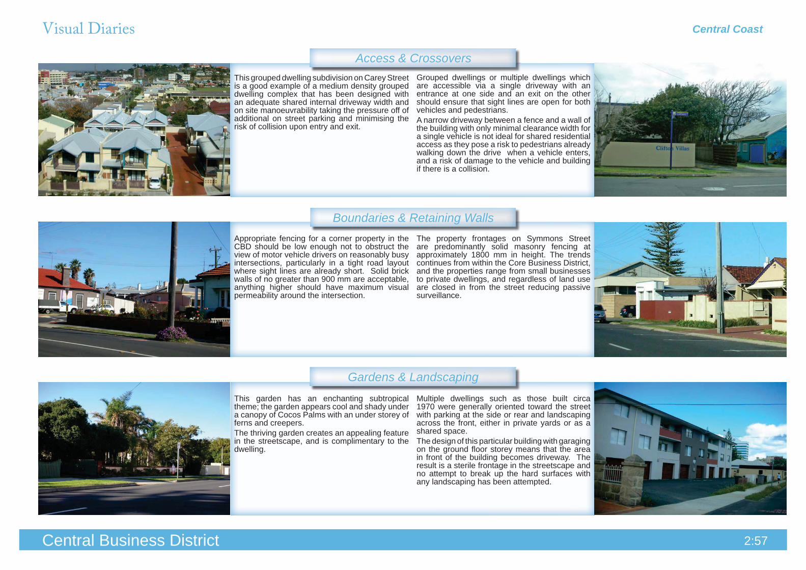
Multiple dwellings such as those built circa 1970 were generally oriented toward the street with parking at the side or rear and landscaping across the front, either in private yards or as a shared space. The design of this particular building with garaging on the ground floor storey means that the area in front of the building becomes driveway. The result is a sterile frontage in the streetscape and no attempt to break up the hard surfaces with any landscaping has been attempted.
The property frontages on Symmons Street are predominantly solid masonry fencing at approximately 1800 mm in height. The trends continues from within the Core Business District, and the properties range from small businesses to private dwellings, and regardless of land use are closed in from the street reducing passive surveillance.
Grouped dwellings or multiple dwellings which are accessible via a single driveway with an entrance at one side and an exit on the other should ensure that sight lines are open for both vehicles and pedestrians.A narrow driveway between a fence and a wall of the building with only minimal clearance width for a single vehicle is not ideal for shared residential access as they pose a risk to pedestrians already walking down the drive when a vehicle enters, and a risk of damage to the vehicle and building if there is a collision.
This grouped dwelling subdivision on Carey Street is a good example of a medium density grouped dwelling complex that has been designed with an adequate shared internal driveway width and on site manoeuvrability taking the pressure off of additional on street parking and minimising the risk of collision upon entry and exit.
This garden has an enchanting subtropical theme; the garden appears cool and shady under a canopy of Cocos Palms with an under storey of ferns and creepers. The thriving garden creates an appealing feature in the streetscape, and is complimentary to the dwelling.
Appropriate fencing for a corner property in the CBD should be low enough not to obstruct the view of motor vehicle drivers on reasonably busy intersections, particularly in a tight road layout where sight lines are already short. Solid brick walls of no greater than 900 mm are acceptable, anything higher should have maximum visual permeability around the intersection.

Central CoastVisual Diaries
2:58Central Business District
Building Materials & Construction
Building Style & Character
Building Setback & Orientation
Clifton Street has a high density area, and recent developments reflect inner city living with short setbacks on grouped dwellings that are consistent with the rest of the established street. The narrow row dwellings and simple gable forms reflect similar designs of the established older buildings in the surrounding area. The variations in facade treatments and fencing provide some visual relief from the identical pattern in the built form.
These grouped dwellings are a simple box-like formation with minimal openings in the upper storey, and no aspect toward the street. The simple form is accentuated by the flat roof design and the absence of fenestration detracts from the residential character.
Buildings that cannot be demolished because they hold heritage value are sometimes not maintained, if they are no longer in use, or lack the funding and priority for maintenance.Boarding up windows to prevent vandalism is not a preferred means of security, as it creates an unsightly impact on the building, and character of the street. However, it is acknowledged that high exposure in a public area works unfavourably against conventional measures for preventing vandalism and entry.
This dwelling has been maintained, and the original character is present; irrespective of some work to the original stone work roof sheeting.The maintenance and upkeep of materials contributes to the life span of the building, and creates a positive contribution to the streetscape.
This set of grouped dwellings built on the corner of Upper Esplanade and Symmons Street encompass inner city living in a coastal amenity. The orientation of the dwellings takes advantage of northern solar access and ocean views. Upper storeys are setback by balconies which provide shade to the habitable areas; however some of the areas have been enclosed to form to protect entertaining areas against the elements.
Front setbacks for new dwelling in existing streetscapes should be developed in line with the adjoining dwellings on the street or where differing setbacks occur, the average of the two adjoining properties is appropriate. The greater the setback distance between two adjoining properties, the greater the impact on the streetscape.Setback requirements that allow new dwellings to be setback to a standard minimum do not take into account existing conditions and cause these interruptions in the rhythm of the streetscape.

Koombana BayCharacter Mapping
Public Art Works
2:59Central Business District
Aerial ViewLocal Area Character
Landmarks / Features
City Vision Strategy
Boundaries
Koombana Bay marks the first entry point into the City and provides the first views of the CBD across the Inlet and views across the Bay. The land is predominantly Regional Open Space under the Greater Bunbury Region Scheme and Parks and Recreation under the Town Planning Scheme, with a small residential community and caravan park, and short stay accommodation. The Koombana Bay Sailing Club and Dolphin Discovery Centre sit on the waterfront of the public beach.The Inner Harbour is located to the south of the Bay, where the character dramatically changes from open coastal and estuarine environment to a heavy port industry, partially concealed by landscaping with immense wood chip piles and machinery puncturing the landscape.The old Outer Harbour freight railway line follows Koombana Drive around to the Plug where it terminates at present; the future use of the rail corridor still an uncertainty.
The Koombana Drive / Blair Street roundabout to the north,
Koombana Bay foreshore to the east,Inner Harbour to the
sou th and the Leschenault Inlet and Public Open Space curving to the west.
CBD31: Subject to detailed site analysis, endorse the location of a museum, Noongar cultural centre and new visitor centre between the mangrove colony and Koombana Drive as part of a tourism node that includes the Dolphin Discovery Centre. Subject to further investigation, consideration be given to locating the Bunbury Regional Art Gallery at this location.
CBD32: That permanent residential not be supported (with the exception of nonstrategic tourism sites where 25% residential may be permitted) because of proximity to the port, the high value of the land for alternative uses and insufficient numbers to create a liveable neighbourhood unit.
CBD33: That the Koombana Bay Sailing Club location be further investigated for a marina development in conjunction with planning for the OuterHarbour that can accommodate all water based community groups and the general public.
Top to Bottom: Dolphin Discovery Centre, White Mangroves
Koombana Drive Local Centre(Located in the Caravan Park)
Various timber carved nautical and exploration themed artworks in POS
Central Business District Investigation Area
Activity Centres
Visual Diaries Koombana Bay
2:60Central Business District
Road Layout
Street Trees & Landscaping
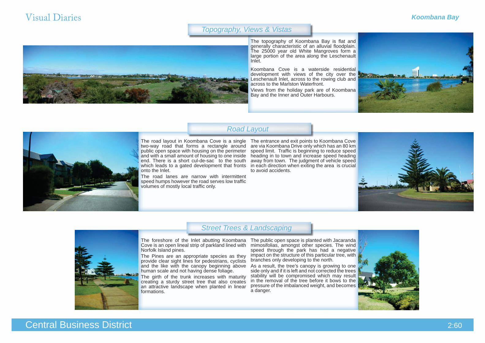
The topography of Koombana Bay is flat and generally characteristic of an alluvial floodplain. The 25000 year old White Mangroves form a large portion of the area along the Leschenault Inlet.
Koombana Cove is a waterside residential development with views of the city over the Leschenault Inlet, across to the rowing club and across to the Marlston Waterfront.Views from the holiday park are of Koombana Bay and the Inner and Outer Harbours.
The road layout in Koombana Cove is a single two-way road that forms a rectangle around public open space with housing on the perimeter and with a small amount of housing to one inside end. There is a short cul-de-sac to the south which leads to a gated development that fronts onto the Inlet.The road lanes are narrow with intermittent speed humps however the road serves low traffic volumes of mostly local traffic only.
The entrance and exit points to Koombana Cove are via Koombana Drive only which has an 80 km speed limit. Traffic is beginning to reduce speed heading in to town and increase speed heading away from town. The judgment of vehicle speed in each direction when exiting the area is crucial to avoid accidents.
The foreshore of the Inlet abutting Koombana Cove is an open lineal strip of parkland lined with Norfolk Island pines. The Pines are an appropriate species as they provide clear sight lines for pedestrians, cyclists and the like with the canopy beginning above human scale and not having dense foliage. The girth of the trunk increases with maturity creating a sturdy street tree that also creates an attractive landscape when planted in linear formations.
The public open space is planted with Jacaranda mimosifolias, amongst other species. The wind speed through the park has had a negative impact on the structure of this particular tree, with branches only developing to the north. As a result, the tree’s canopy is growing to one side only and if it is left and not corrected the trees stability will be compromised which may result in the removal of the tree before it bows to the pressure of the imbalanced weight, and becomes a danger.
Topography, Views & Vistas

Visual Diaries Koombana Bay
2:61Central Business District
Pedestrian & Bicycle Pathways
Lighting, Signage & Furniture
Public Open Space
The Dolphin Discovery Centre located on the edge of Koombana Beach foreshore is a not for profit organisation that conduct research and eco-tourism on bottle neck dolphins. The building is located away from the main road, and if not for the signage painted onto the side it would go largely unnoticed.The impact of such advertising is beneficial for such an organisation as it is directional signage that is prominent from the main road and forms a recognisable feature in that landscape.
Avoiding dependence on bollard lighting as the only light source and instead using lighting along footpaths that is mounted at a height that does not obstruct the pedestrian from seeing clearly ahead and around them and sufficiently covers the majority of path to avoid any dangerous lurking points in cast shadows.Lighting should designed as an early consideration and should be appropriate in the local context. (Designing Out Crime 2006:33)
Sykes Foreshore reserve is on the edge of the Leschenault Inlet between Koombana Park and the Bunbury Power Boat Club. With ample car parking and pedestrian connectivity, the park is popular with young families, and for social events and picnics.Good elements of design include; mature trees, shelters, play equipment, benches, car parking, pedestrian access and public amenities.
The parkland adjacent the existing caravan park off of Koombana Drive is an under utilised parcel of land that is zoned for both public open space and special uses at present. The oval sized area forms a shallow basin; and because the land is not flat it does not get used on a regular basis, with the exception of overflow car parking during community events.
Wide, open, and clearly delineated shared access paths that connect residential areas with public open spaces are an asset to the neighbourhood. The width of a shared path should be a minimum of 2 metres and a maximum of 3.5 metres depending on the location and expected traffic flow. (Liveable Neighbourhoods 2004:58)
Pedestrian accessways need to facilitate good sight lines so that the ability to see ahead and around the route is not compromised. This is known as ‘visual permeability’. Features that facilitate sight lines are low hedges, and fences, gardens and benches. Way finding is the use of symbols, cues and signage to help navigate through areas, to guide appropriate use of this space and make inappropriate use obvious to others. (Designing Out Crime, 2006:38)

Visual Diaries Koombana Bay
2:62Central Business District
Gardens & Landscaping
Boundaries & Retaining Walls
Access & Crossovers
The road layout in Koombana Cove is predominantly one way traffic around a central public park. As such, drivers have a higher level of safety when reversing out of private driveways. It is also quite common for cars to use the ample verges on either side of the road for parking vehicles as the carriage way is quite narrow.
Front and side fencing sometimes encloses the dwelling’s main area of private open space particularly on smaller corner lots. Combining privacy and passive surveillance of the street can be achieved with medium height landscaping on either side of the boundary, to create an informal screen.
The timber fencing that surrounds the holiday park which was once painted green is now severely stained by the ongoing use of bore water in the vicinity. Care should be taken to design irrigation systems to avoid direct spraying of fencing, however material selection should be considered where it is known that exposure to bore water will be imminent.
This garden applies a passive surveillance screening technique in conjunction with an open style of front fencing between private open space and the street. The vegetation is planted on both sides of the boundary and is a balance of small shrubs and trees that will mature into a well balanced screen.
Because there is a large component of high density dwellings in the development, there is not an extensive range of private gardens. However, the public street trees and garden beds incorporate a consistent level of planting to the front of each dwelling, which provides a uniform pattern in the streetscape and is maintained to a high level.
The grouped dwellings that are accessible off of Lyons Cove and Marabank Loop have a shared access arrangement that accommodates ample two way access for easy manoeuvrability for two cars to pass each other whilst allowing for turning into and out of private garages with ease.

Visual Diaries Koombana Bay
2:63Central Business District
Building Materials & Construction
Building Style & Character
Building Setback & OrientationThese dwellings display good north-easterly aspect for passive solar design. The upper storey windows of the dwellings are orientated to receive winter morning to midday sunlight and have individual shading devices to prevent over heating in Summer months.
With Australia’s mostly temperate climate it is recommended that all north and west facing windows/ openings that receive direct afternoon solar access should incorporate eaves/ awnings that provide adequate sunlight and shading to living areas. This varies across Australia and calculations for solar access are determined by region, if applied correctly the use of eaves and awning can increase the thermal comfort of the building passively.
This residential development comprising 4 grouped dwellings is an example of how the LPP: Koombana Cove Design Guidelines were intended to be applied. The dwellings include a 3 storey component (maximum building height) that maximise waterfront views to the Inlet.Housing design is encouraged to reflect the coastal area, and respond to climatic conditions and contemporary coastal identity.
The Bunbury Power Boat Club building on the foreshore of the Inlet (to the south of the residential estate) was built several decades before Koombana Cove was established.The proposed Bunbury Waterfront Project (concept) aims to improve the amenity of the foreshore and provide interconnected facilities for community use, in addition to the proposed built form component. Opportunities exist to incorporate a high amenity foreshore on both sides of the Inlet, including improvements to this site, in order to provide consistency and balance in the landscape.
Quality of building materials and workmanship conveys a strong sense of character and aesthetic appeal.The level of quality of design and materials varies across the residential building industry making the high quality housing design of this precinct a positive addition to the streetscape.Features such as passive solar design and orientation, are enhanced with quality workmanship to achieve sustainable building design.
Untreated bore water set too close to building walls creates unsightly marking on many surfaces.Whilst it only visually affects the structure, it can be prevented by implementing landscaping plans that are require plants to be far enough away from the wall so as not to be affected by the spray pattern of the irrigation system.

Strategic Planning Central Business District
2:642:64Central Business District
A Vision for the FutureThe CBD will experience commercial and residential growth predominantly to the north, including • the CBD Core and Marlston Waterfront precincts. High rise buildings may be incorporated along Victoria Street and some potential increases to • the height of buildings along Prinsep and Stephen Streets, and between Victoria Street and Blair Street to the north.Increased residential density to reflect inner city living household needs. • Improved pedestrianisation of linkages between the CBD Core and the Marlston Waterfront• Improved vehicle circulation and availability of car parking within the city centre and periphery.• The commencement of the Bunbury Waterfront Project.•
Valuable Landscape Character Elements to Promote & EnhanceThe ‘Three Waters’ are the city’s most valuable landscapes, and together should be promoted • as the city’s greatest asset to lifestyle and amenity.The Bunbury Tower is a valuable asset to the identity of Bunbury, being the ‘Milk Carton’ on the • skyline, it is a point of reference within the city, and has been used as an icon for logos, slogans, and advertising campaigns across the southwest. The White Mangroves are a significant natural landscape that has high ecological and historical • value in the landscape. Accessibility should be maintained for public access and educational programs should continue.
Important Views and Vistas to RetainThe Marlston Lookout has significant view for 360 degrees from the top platform.• The Bunbury Tower is an identifiable feature on the Bunbury skyline and viewsheds should be • retained to the Tower from key viewpoints across the CBD. The Silos redevelopment is a dominant feature in the landscape and viewsheds should be • retained from key viewpoints across the CBD, in particular the ‘Gateway’ bridge, and from the Marlston Lookout.Pedestrian views down Symmons Street that connect Back Beach with the Leschenault Inlet.•
Policy RecommendationsInforming the preparation of the Local Planning Strategy for Activity Centres & • Neighbourhoods.Implementation of the R-Codes Omnibus Amendment.• Commencement of the local area planning process and subsequent Local Planning Policy: • Central Business District Local Area Plan.Review of the existing local planning policies in effect that regulate development, consolidation • and updating of current regulations in preparation for integration with the LAP.Initiation of Scheme Amendments to comply with GBRS zoning for the purpose of the Bunbury • Waterfront Project Stage 1 commencement.Introduction of CPTED principles into local planning policy guidelines. •