Landscape Architecture Portfolio
-
Upload
emmanuel-moran -
Category
Documents
-
view
212 -
download
0
description
Transcript of Landscape Architecture Portfolio
EMMANUEL MORAN VELEZ
LANDSCAPE ARCHITECTURE PORTFOLIO

The understanding of various variables within a site is a step towards the developing of a functional system. Within a system every element has an aff ect towards other elements in a site. The value of each element is equally responsible to the functionality of the site being proposed. Upon deciding how a site can be functional and sustainable, a strict observation
and analysis of the site must be collected. With the analysis and context data collected of both the site and surrounding
systems the process of developing a strategic design initiates. The understanding of the variables that currently create the
existing system can lead to appropriate design decision for the site. Human involvement and usage is important to understand
the interaction between the habitat created and the spaces provided. Every system developed has the opportunity
to inhabited species other than human. Understanding the conditions needed for migratory species relies on the
appropriate plant selection and spaces provided. I believe in allowing the user to enjoy the aesthetics of a working
ecosystem while allowing interaction with the systems. I view the development of a site as an improvement to a large scale
system.
EMMANUEL MORAN VELEZ
210 Lake st. Apt.12DIthaca, NY 14850
2405 Crotona Ave. Apt.19Bronx, NY 10458
(607)319-9154
VISION
:E
:A
:P
1
12
10
8
6
4
2
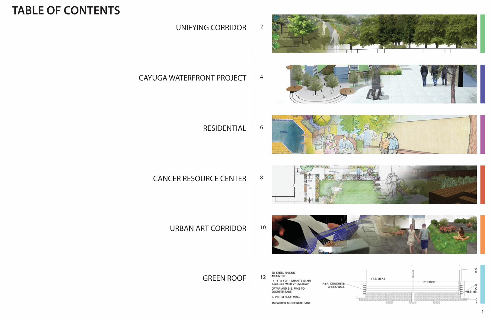
TABLE OF CONTENTS
RESIDENTIAL
CANCER RESOURCE CENTER
CAYUGA WATERFRONT PROJECT
UNIFYING CORRIDOR
URBAN ART CORRIDOR
GREEN ROOF
2
DRY UPLAND
Juglans nigra
Quercus rubra
Quercus macrocarpa
Cercidiphyllum japonicum
Fraxinus pennsylvanica
HABITAT
BLUE SAGE
GARDEN PHLOX
ROSE VERBENA
PRAIRE DROPSEED
BLUE FALSE INDIGO
PURPLE POPPY MALLOW
BUTTERFLY WEED
BUTTONBUSH
JUDDS FALLS
JUDDS FALLS
FOUNDERS’ CASCADILLACREEK
NORTH CAMPUS
FALLCREEK
NORTH CAMPUS
FOUNDERS’
FALL CREEK
CASCADILLA CREEK
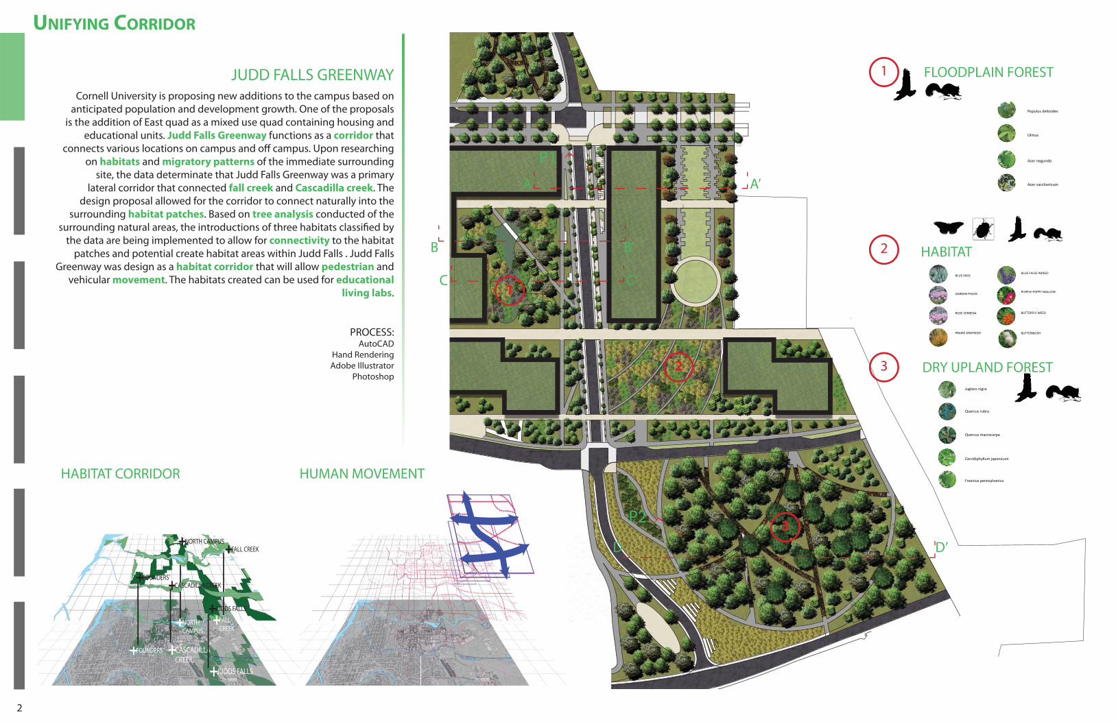
Cornell University is proposing new additions to the campus based on anticipated population and development growth. One of the proposals
is the addition of East quad as a mixed use quad containing housing and educational units. Judd Falls Greenway functions as a corridor that
connects various locations on campus and off campus. Upon researching on habitats and migratory patterns of the immediate surrounding
site, the data determinate that Judd Falls Greenway was a primary lateral corridor that connected fall creek and Cascadilla creek. The
design proposal allowed for the corridor to connect naturally into the surrounding habitat patches. Based on tree analysis conducted of the
surrounding natural areas, the introductions of three habitats classifi ed by the data are being implemented to allow for connectivity to the habitat
patches and potential create habitat areas within Judd Falls . Judd Falls Greenway was design as a habitat corridor that will allow pedestrian and
vehicular movement. The habitats created can be used for educational
living labs.
PROCESS:AutoCAD
Hand RenderingAdobe Illustrator
Photoshop
UNIFYING CORRIDOR
JUDD FALLS GREENWAY
C’
FLOOPLAIN FORESPopulus deltoides
Ulmus
Acer negundo
Acer saccharinum
C
3
3
2
2
1
1
A’A
P1
P2
B B’
D’D
HUMAN MOVEMENT
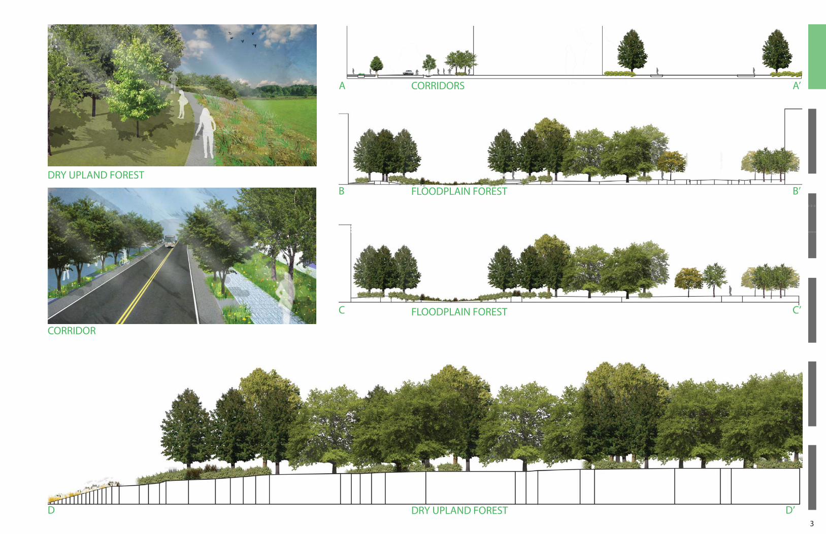
DRY UPLAND FOREST
HABITAT
FLOODPLAIN FOREST
HABITAT CORRIDOR
3
C
D
CORRIDORS
C’
D’
A’A
B B’
FLOODPLAIN FOREST
DRY UPLAND FOREST
CORRIDOR
FLOODPLAIN FOREST
DRY UPLAND FOREST
4
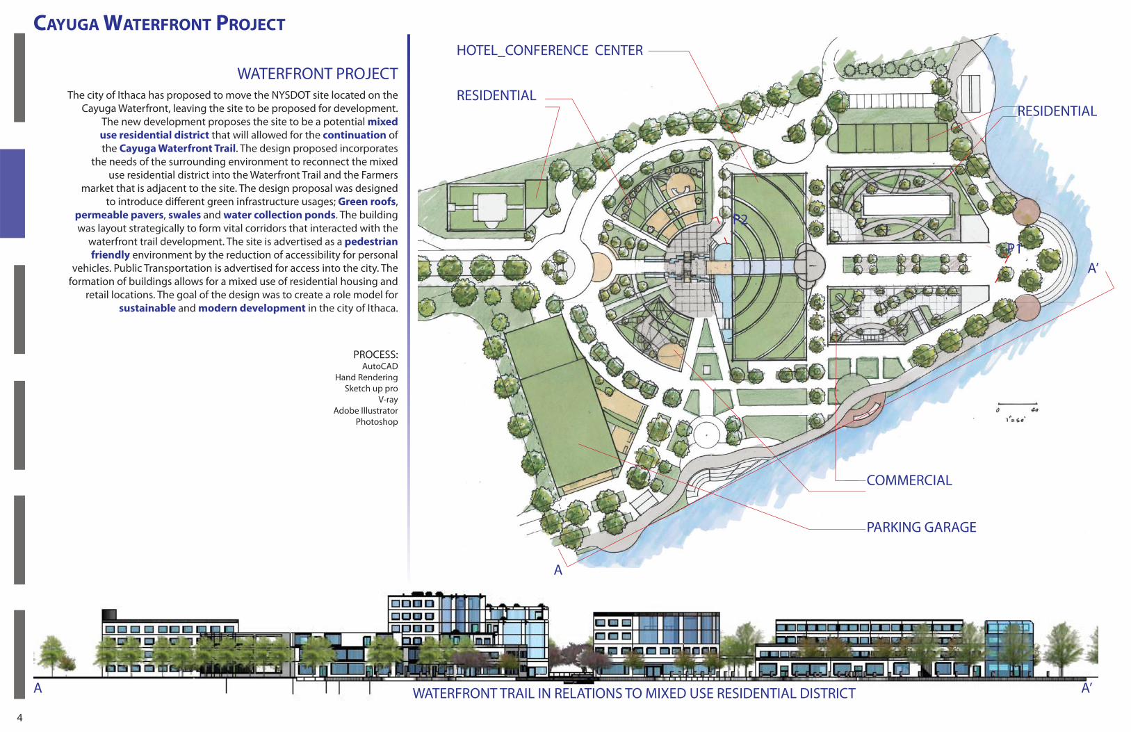
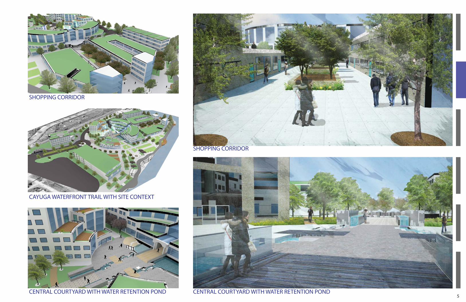
WATERFRONT PROJECT
CAYUGA WATERFRONT PROJECT
The city of Ithaca has proposed to move the NYSDOT site located on the Cayuga Waterfront, leaving the site to be proposed for development.
The new development proposes the site to be a potential mixed
use residential district that will allowed for the continuation of the Cayuga Waterfront Trail. The design proposed incorporates
the needs of the surrounding environment to reconnect the mixed use residential district into the Waterfront Trail and the Farmers
market that is adjacent to the site. The design proposal was designed to introduce diff erent green infrastructure usages; Green roofs,
permeable pavers, swales and water collection ponds. The building was layout strategically to form vital corridors that interacted with the
waterfront trail development. The site is advertised as a pedestrian
friendly environment by the reduction of accessibility for personal vehicles. Public Transportation is advertised for access into the city. The
formation of buildings allows for a mixed use of residential housing and retail locations. The goal of the design was to create a role model for
sustainable and modern development in the city of Ithaca.
A’P1
P2
A’
A
A
RESIDENTIALRESIDENTIAL
WATERFRONT TRAIL IN RELATIONS TO MIXED USE RESIDENTIAL DISTRICT
COMMERCIAL
PARKING GARAGE
HOTEL_CONFERENCE CENTER
PROCESS:AutoCAD
Hand Rendering Sketch up pro
V-rayAdobe Illustrator
Photoshop
5
SHOPPING CORRIDOR
CENTRAL COURTYARD WITH WATER RETENTION PONDCENTRAL COURTYARD WITH WATER RETENTION POND
CAYUGA WATERFRONT TRAIL WITH SITE CONTEXT
SHOPPING CORRIDOR
6
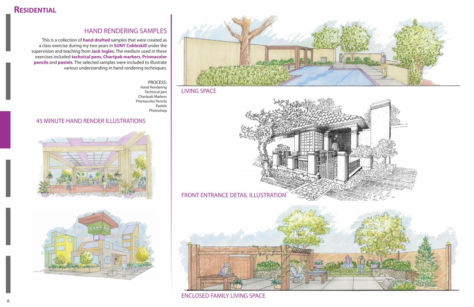
RESIDENTIAL
This is a collection of hand drafted samples that were created as a class exercise during my two years in SUNY Cobleskill under the
supervision and teaching from Jack Ingles. The medium used in these exercises included technical pens, Chartpak markers, Prismacolor
pencils and pastels. The selected samples were included to illustrate various understanding in hand rendering techniques.
HAND RENDERING SAMPLES
45 MINUTE HAND RENDER ILLUSTRATIONS
LIVING SPACE
ENCLOSED FAMILY LIVING SPACE
FRONT ENTRANCE DETAIL ILLUSTRATION
PROCESS:Hand Rendering
Technical penChartpak Markers
Prismacolor Pencils Pastels
Photoshop
7
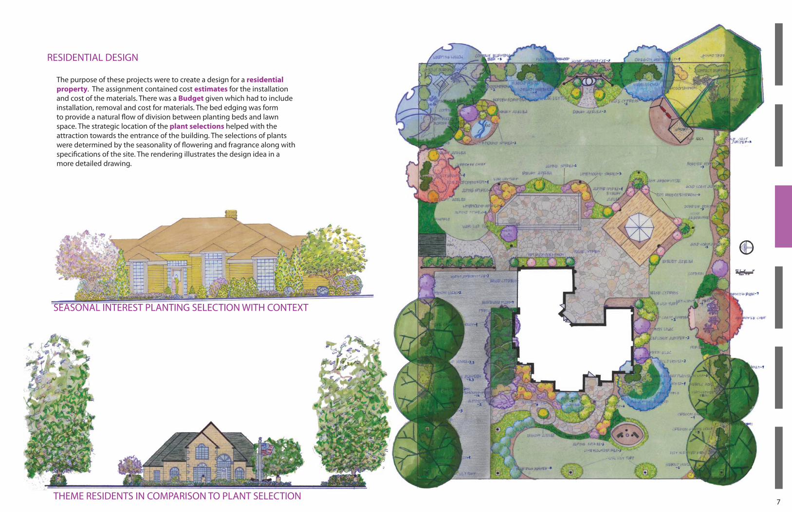
The purpose of these projects were to create a design for a residential
property. The assignment contained cost estimates for the installation and cost of the materials. There was a Budget given which had to include installation, removal and cost for materials. The bed edging was form to provide a natural fl ow of division between planting beds and lawn space. The strategic location of the plant selections helped with the attraction towards the entrance of the building. The selections of plants were determined by the seasonality of fl owering and fragrance along with specifi cations of the site. The rendering illustrates the design idea in a more detailed drawing.
SEASONAL INTEREST PLANTING SELECTION WITH CONTEXT
THEME RESIDENTS IN COMPARISON TO PLANT SELECTION
RESIDENTIAL DESIGN
8
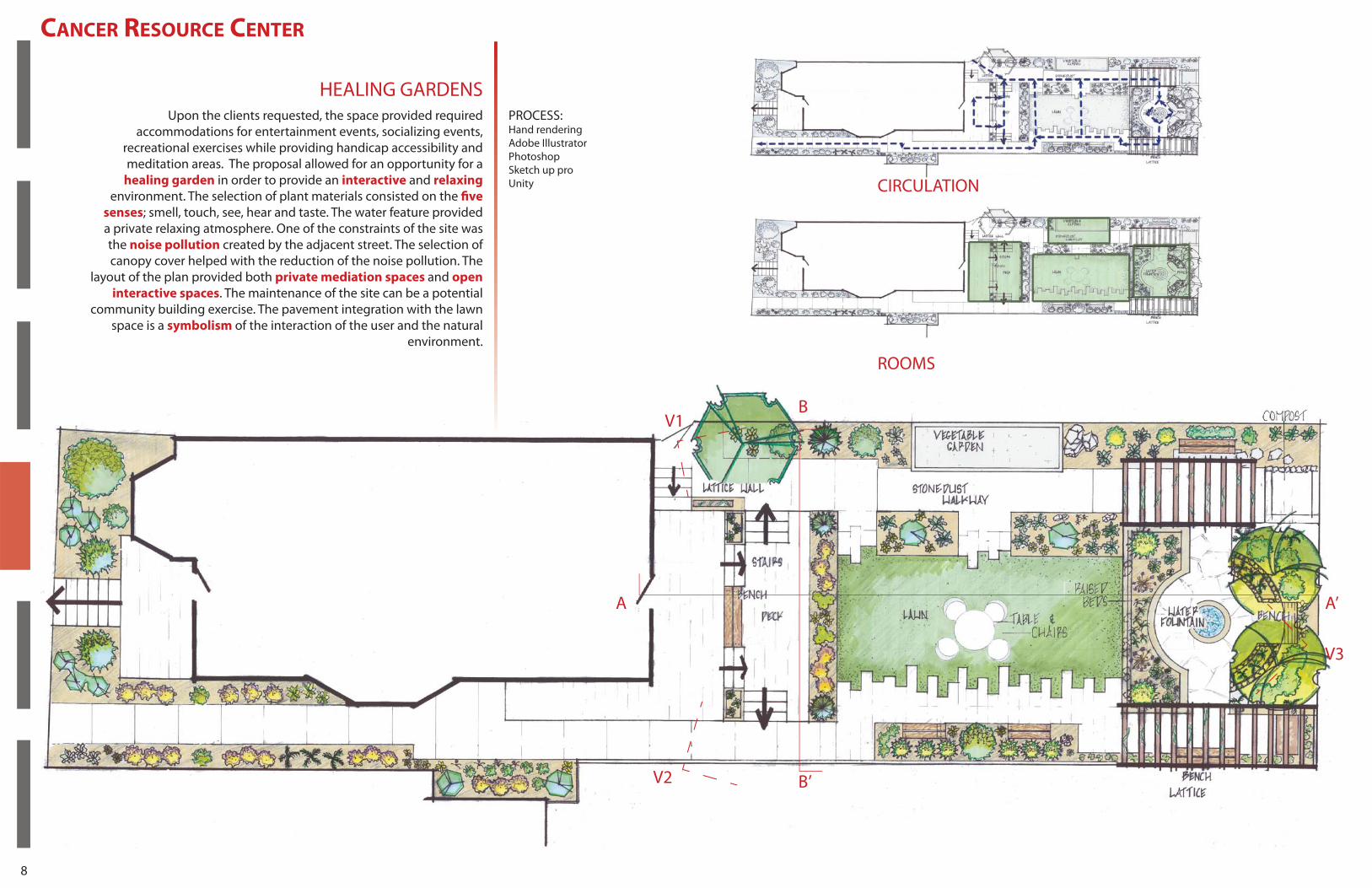
HEALING GARDENS
CANCER RESOURCE CENTER
Upon the clients requested, the space provided required accommodations for entertainment events, socializing events,
recreational exercises while providing handicap accessibility and meditation areas. The proposal allowed for an opportunity for a
healing garden in order to provide an interactive and relaxing environment. The selection of plant materials consisted on the fi ve
senses; smell, touch, see, hear and taste. The water feature provided a private relaxing atmosphere. One of the constraints of the site was the noise pollution created by the adjacent street. The selection of canopy cover helped with the reduction of the noise pollution. The
layout of the plan provided both private mediation spaces and open
interactive spaces. The maintenance of the site can be a potential community building exercise. The pavement integration with the lawn
space is a symbolism of the interaction of the user and the natural environment.
A
B
B’V2
V3
V1
A’
ROOMS
CIRCULATION
PROCESS:Hand renderingAdobe IllustratorPhotoshopSketch up proUnity
9
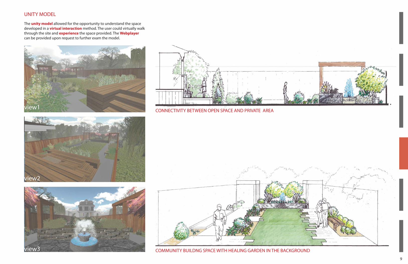
The unity model allowed for the opportunity to understand the space developed in a virtual interaction method. The user could virtually walk through the site and experience the space provided. The Webplayer can be provided upon request to further exam the model.
UNITY MODEL
CONNECTIVITY BETWEEN OPEN SPACE AND PRIVATE AREA
COMMUNITY BUILDNG SPACE WITH HEALING GARDEN IN THE BACKGROUND
view1
view2
view3
10
11
1
2
2
33
3
4
4
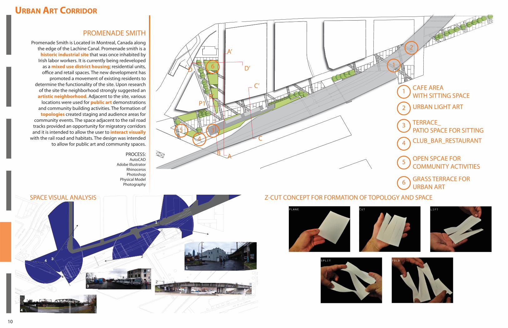
URBAN ART CORRIDOR
PROMENADE SMITH
SPACE VISUAL ANALYSIS Z-CUT CONCEPT FOR FORMATION OF TOPOLOGY AND SPACE
Promenade Smith is Located in Montreal, Canada along the edge of the Lachine Canal. Promenade smith is a
historic industrial site that was once inhabited by Irish labor workers. It is currently being redeveloped
as a mixed use district housing; residential units, offi ce and retail spaces. The new development has
promoted a movement of existing residents to determine the functionality of the site. Upon research
of the site the neighborhood strongly suggested an artistic neighborhood. Adjacent to the site, various
locations were used for public art demonstrations and community building activities. The formation of
topologies created staging and audience areas for community events. The space adjacent to the rail road tracks provided an opportunity for migratory corridors and it is intended to allow the user to interact visually
with the rail road and habitats. The design was intended to allow for public art and community spaces.
A’
AB
B’P1
C’
D’D
C
PROCESS:AutoCAD
Adobe IllustratorRhinocerosPhotoshop
Physical ModelPhotography
URBAN LIGHT ART
CAFE AREA WITH SITTING SPACE
1
2
33
44
5
5
6
6
TERRACE_PATIO SPACE FOR SITTING
CLUB_BAR_RESTAURANT
GRASS TERRACE FOR URBAN ART
OPEN SPCAE FOR COMMUNITY ACTIVITIES
1
2
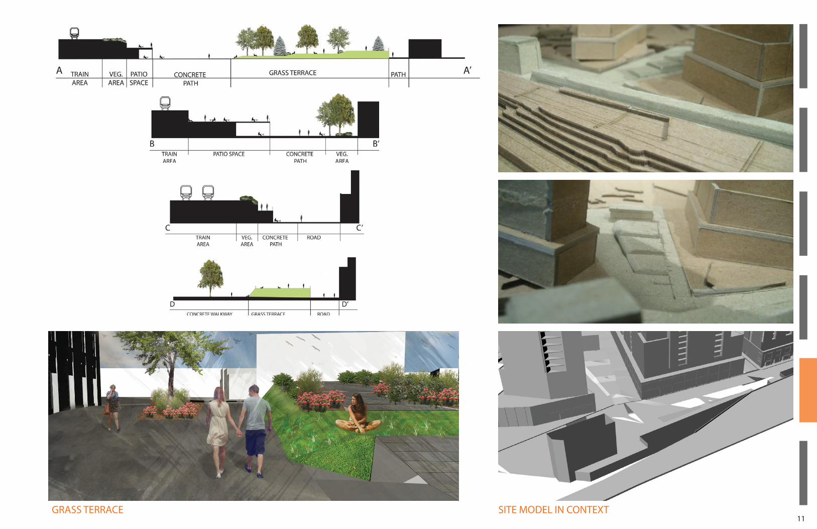
11SITE MODEL IN CONTEXTGRASS TERRACE
12
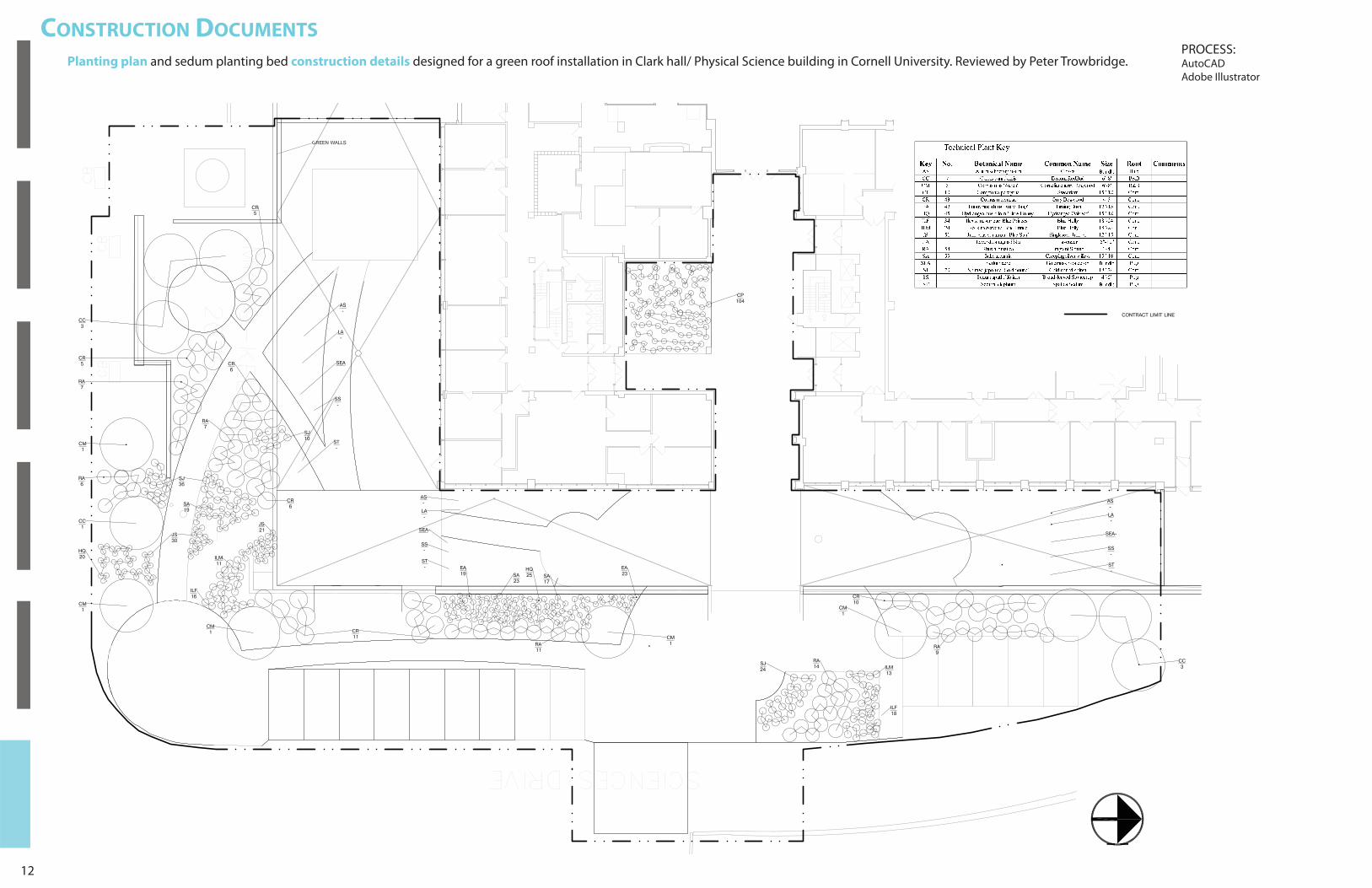
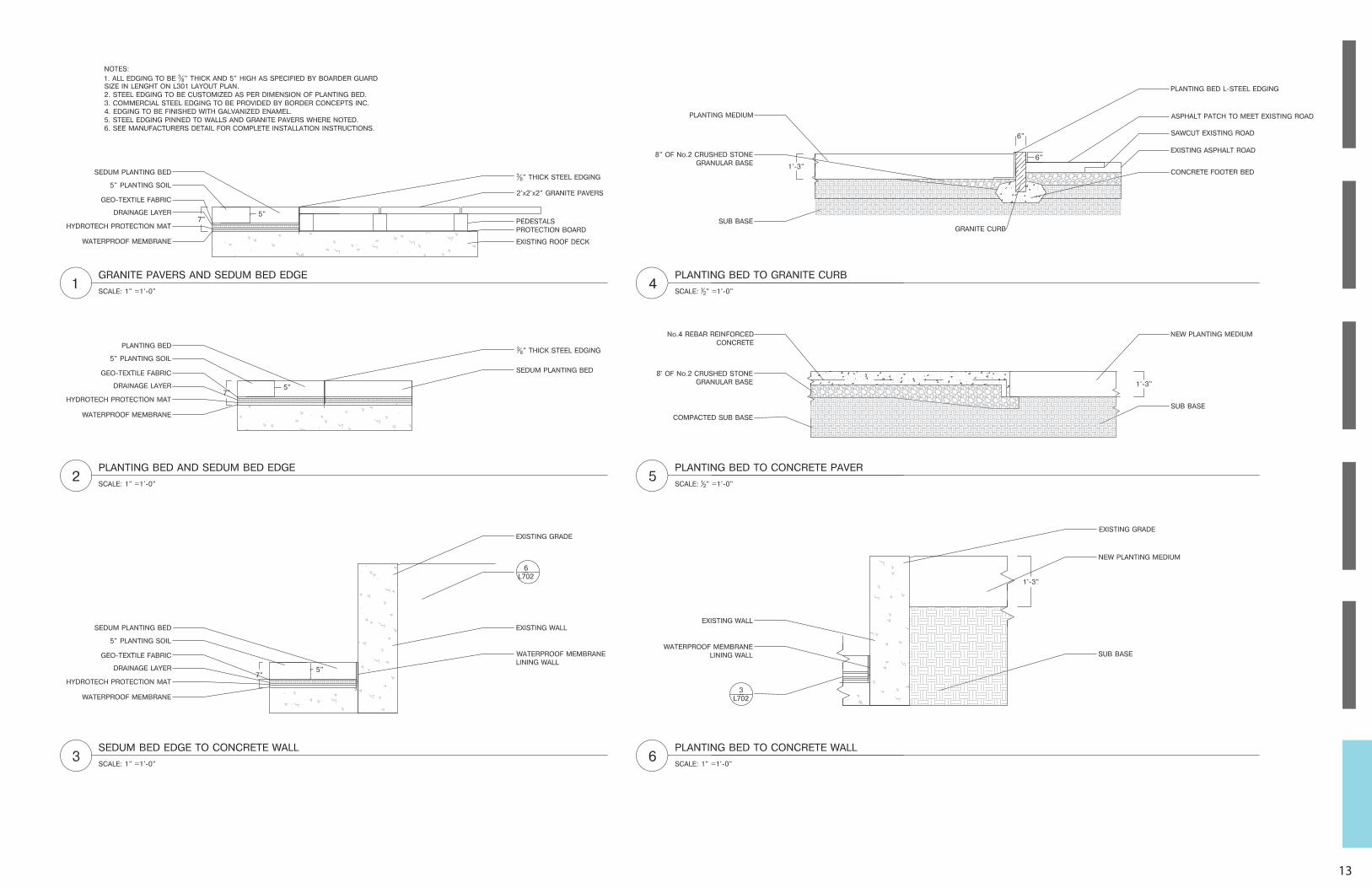
CONSTRUCTION DOCUMENTS
Planting plan and sedum planting bed construction details designed for a green roof installation in Clark hall/ Physical Science building in Cornell University. Reviewed by Peter Trowbridge.PROCESS:AutoCADAdobe Illustrator
13

EMMANUEL MORAN VELEZ
210 Lake st. Apt.12DIthaca, NY 14850
2405 Crotona Ave. Apt.19Bronx NY 10458
(607)319-9154
A:
E:
P: